using resistance and resilience concepts to reduce impacts...
TRANSCRIPT
Forest Service Rocky Mountain Research Station General Technical Report RMRS-GTR-326 September 2014
United States Department of Agriculture
Using Resistance and Resilience Concepts to Reduce Impacts of Invasive Annual Grasses and Altered Fire Regimes on the Sagebrush Ecosystem and Greater Sage-Grouse: A Strategic Multi-Scale Approach
Jeanne C. Chambers, David A. Pyke, Jeremy D. Maestas, Mike Pellant, Chad S. Boyd, Steven B. Campbell, Shawn Espinosa, Douglas W. Havlina, Kenneth E. Mayer, and Amarina Wuenschel
#824
Chambers, Jeanne C.; Pyke, David A.; Maestas, Jeremy D.; Pellant, Mike; Boyd, Chad S.; Campbell, Ste-ven B.; Espinosa, Shawn; Havlina, Douglas W.; Mayer, Kenneth E.; Wuenschel, Amarina. 2014. Using resistance and resilience concepts to reduce impacts of invasive annual grasses and altered fire regimes on the sagebrush ecosystem and greater sage-grouse: A strategic multi-scale approach. Gen. Tech. Rep. RMRS-GTR-326. Fort Collins, CO: U.S. Department of Agriculture, Forest Service, Rocky Mountain Research Station. 73 p.
Abstract This Report provides a strategic approach for conservation of sagebrush ecosystems and Greater Sage-Grouse (sage-grouse) that focuses specifically on habitat threats caused by invasive annual grasses and altered fire regimes. It uses information on factors that influence (1) sagebrush ecosystem resilience to distur-bance and resistance to invasive annual grasses and (2) distribution, relative abundance, and persistence of sage-grouse populations to develop management strategies at both landscape and site scales. A sage-grouse habitat matrix links relative resilience and resistance of sagebrush ecosystems with sage-grouse habitat re-quirements for landscape cover of sagebrush to help decision makers assess risks and determine appropriate management strategies at landscape scales. Focal areas for management are assessed by overlaying matrix components with sage-grouse Priority Areas for Conservation (PACs), breeding bird densities, and specific habitat threats. Decision tools are discussed for determining the suitability of focal areas for treatment and the most appropriate management treatments.
Keywords: sagebrush habitat, Greater Sage-Grouse, fire effects, invasive annual grasses, management prioritization, conservation, prevention, restoration
Cover photos: Greater Sage-grouse photo by Rick McEwan; sagebrush habitat photos by Jeanne Chambers.

You may order additional copies of this publication by sending your mailing information in label form through one of the following media. Please specify the publication title and number.
Publishing Services Web site http://www.fs.fed.us/rmrs
Email [email protected]
Mailing Address Publications Distribution Rocky Mountain Research Station 240 West Prospect Road Fort Collins, CO 80526
AuthorsJeanne C. Chambers, Research Ecologist, USDA Forest Service, Rocky Mountain Research Station, Reno, Nevada.
David A. Pyke, Research Ecologist, U.S. Geological Survey, Forest & Rangeland Ecosystem Science Center, Corvallis, Oregon.
Jeremy D. Maestas, Technical Lead, Sage-Grouse Initiative, USDA Natural Resources Conservation Service, Redmond, Oregon.
Mike Pellant, Rangeland Ecologist, USDI Bureau of Land Management, Boise, Idaho.
Chad S. Boyd, Rangeland Ecologist, USDA Agricultural Research Service, Burns, Oregon.
Steven B. Campbell, Soil Scientist, USDA Natural Resources Conservation Service, West National Technology Support Center, Portland, Oregon.
Shawn Espinosa, Wildlife Staff Specialist, Nevada Department of Wildlife, Reno, Nevada.
Douglas W. Havlina, Fire Ecologist, USDI Bureau of Land Management, National Interagency Fire Center, Boise, Idaho.
Kenneth E. Mayer, Wildlife Ecologist, Western Association of Fish and Wildlife Agen-cies, Sparks, Nevada.
Amarina Wuenschel, Geospatial Data Specialist, Great Basin Landscape Conserva-tion Cooperative, Reno, Nevada.
Acknowledgments We thank the Western Association of Fish and Wildlife Agencies, Fire and Invasives Working group, for critical input into the content of the Report; Steve Knick and Steve Hanser for advice on landscape cover of sagebrush; and three anonymous reviewers for valuable comments on the manuscript. We also thank the Great Basin Landscape Conservation Cooperative for providing the expertise (Amarina Wuenschel) and sup-port for the spatial analyses.

Introduction .............................................................................................................. 1
Threats of Invasive Annual Grasses and Altered Fire Regimes to Sagebrush Ecosystems and Sage-Grouse ....................................................... 3
Effects on Sagebrush Ecosystems ............................................................... 3Effects on Sage-Grouse Habitat Selection and Population Dynamics ......... 7
Resilience to Disturbance and Resistance to Invasive Annual Grasses in Sagebrush Ecosystems ................................................................... 9
Integrating Resilience and Resistance Concepts with Sage-Grouse Habitat Requirements to Manage Wildfire and Invasive Annual Grass Threats at Landscape Scales ....................................................11
Landscape Cover of Sagebrush as an Indicator of Sage-Grouse Habitat ................................................................................................ 12
Soil Temperature and Moisture Regimes as Indicators of Ecosystem Resilience and Resistance ............................................... 13
Management Strategies Based on Landscape Cover of Sagebrush and Ecosystem Resilience and Resistance: The Sage-Grouse Habitat Matrix ........................................................ 19
Informing Wildfire and Fuels Management Strategies to Conserve Sage-Grouse ...................................................................................................... 26
Putting It All Together ........................................................................................... 28Assessing Focal Areas for Sage-Grouse Habitat Management:
Key Data Layers ................................................................................. 28Assessing Focal Areas for Sage-Grouse Habitat Management:
Integrating Data Layers ...................................................................... 34Interpretations at the Management Zone (MZ) Scale:
Western Portion of the Range ............................................................ 46Interpretations at Regional and Local Land Management Scales:
Northeast Nevada Example ................................................................ 48Determining the Most Appropriate Management Treatments at
the Project Scale ................................................................................ 50
References ............................................................................................................. 57
Appendices ............................................................................................................ 63
Contents


1USDA Forest Service Gen. Tech. Rep. RMRS-GTR-326. 2014
Using Resistance and Resilience Concepts to Reduce Impacts of Invasive Annual Grasses and Altered Fire Regimes on the Sagebrush Ecosystem and Greater
Sage-Grouse: A Strategic Multi-Scale Approach
Jeanne C. Chambers, David A. Pyke, Jeremy D. Maestas, Mike Pellant, Chad S. Boyd, Steven B. Campbell, Shawn Espinosa, Douglas W. Havlina,
Kenneth E. Mayer, and Amarina Wuenschel
Introduction ______________________________________________________An unprecedented conservation effort is underway across 11 States in the western
United States to reduce threats to Greater Sage-Grouse (Centrocercus urophasianus; hereafter, sage-grouse) and the sagebrush ecosystems on which they depend (fig. 1). Re-cent efforts were accelerated by the March 2010 determination that sage-grouse warrant protection under the Federal Endangered Species Act, and by increased emphasis on broad collaboration among state and Federal partners to proactively identify and implement actions to reverse current trends (USFWS 2010, 2013). Conservation success hinges on being able to achieve “the long-term conservation of sage-grouse and healthy sagebrush shrub and native perennial grass and forb communities by maintaining viable, con-nected, and well-distributed populations and habitats across their range, through threat amelioration, conservation of key habitats, and restoration activities” (USFWS 2013). While strides are being made to curtail a host of threats across the range, habitat loss and fragmentation due to wildfire and invasive plants remain persistent challenges to
Figure 1. Greater Sage-Grouse (Centrocercus urophasianus) (photo by Charlotte Ganskopp).
2 USDA Forest Service Gen. Tech. Rep. RMRS-GTR-326. 2014
achieving desired outcomes – particularly in the western portion of the range (Miller et al. 2011; USFWS 2010; 2013). Management responses to date have not been able to match the scale of this problem. Natural resource managers are seeking coordinated approaches that focus appropriate management actions in the right places to maximize conservation effectiveness (Wisdom and Chambers 2009; Murphy et al. 2013).
Improving our ability to manage for resilience to disturbance and resistance to inva-sive species is fundamental to achieving long-term sage-grouse conservation objectives. Resilient ecosystems have the capacity to regain their fundamental structure, processes, and functioning when altered by stressors like drought and disturbances like inappropri-ate livestock grazing and altered fire regimes (Holling 1973; Allen et al. 2005). Species resilience refers to the ability of a species to recover from stressors and disturbances (USFWS 2013), and is closely linked to ecosystem resilience. Resistant ecosystems have the capacity to retain their fundamental structure, processes, and functioning when exposed to stresses, disturbances, or invasive species (Folke et al. 2004). Resistance to invasion by nonnative plants is increasingly important in sagebrush ecosystems; it is a function of the abiotic and biotic attributes and ecological processes of an ecosystem that limit the population growth of an invading species (D’Antonio and Thomsen 2004). A detailed explanation of the factors that influence resilience and resistance in sagebrush ecosystems is found in Chambers et al. 2014.
In general, species are likely to be more resilient if large populations exist in large blocks of high quality habitat across the full breadth of environmental variability to which the species is adapted (Redford et al. 2011). Because sage-grouse are a broadly distrib-uted and often wide-ranging species that may move long-distances between seasonal habitats (Connelly et al. 2011a,b), a strategic approach that integrates both landscape prioritization and site-scale decision tools is needed. This document develops such an approach for the conservation of sagebrush habitats across the range of sage-grouse with an emphasis on the western portion of the range. In recent years, information and tools have been developed that significantly increase our understanding of factors that influence the resilience of sagebrush ecosystems and the distribution of sage-grouse populations, and that allow us to strategically prioritize management activities where they are most likely to be effective and to benefit the species. Although the emphasis of this Report is on the western portion of the sage-grouse range, the approach has management applicability to other sagebrush ecosystems.
In this report, we briefly review causes and effects of invasive annual grasses and altered fire regimes, and then discuss factors that determine resilience to disturbances like wildfire and resistance to invasive annual grasses in sagebrush ecosystems. We illustrate how an understanding of resilience and resistance, sagebrush habitat require-ments for sage-grouse, and consequences that invasive annual grasses and wildfire have on sage-grouse populations can be used to develop management strategies at both landscape and site scales. A sage-grouse habitat matrix is provided that links relative resilience and resistance with habitat requirements for landscape cover of sagebrush to both identify priority areas for management and determine effective management strate-gies at landscape scales. An approach for assessing focal areas for sage-grouse habitat management is described that overlays Priority Areas for Conservation (PACs) and breeding bird densities with resilience and resistance and habitat suitability to spatially link sage-grouse populations with habitat conditions and risks. The use of this approach is illustrated for the western portion of the range and for a diverse area in the northeast corner of Nevada. It concludes with a discussion of the tools available for determining the suitability of focal areas for treatment and the most appropriate management treat-ments. Throughout the document, the emphasis is on using this approach to guide and assist fire operations, fuels management, post-fire rehabilitation, and habitat restoration activities to maintain or enhance sage-grouse habitat.
3USDA Forest Service Gen. Tech. Rep. RMRS-GTR-326. 2014
Threats of Invasive Annual Grasses and Altered Fire Regimes to Sagebrush Ecosystems and Sage-Grouse _______________________________________
Effects on Sagebrush Ecosystems
Sage-grouse habitat loss and fragmentation due to wildfire and invasive plants are widely recognized as two of the most significant challenges to conservation of the spe-cies, particularly in the western portion of the range (Miller et al. 2011; USFWS 2010, 2013). During pre-settlement times, sagebrush-dominated ecosystems had highly variable fire return intervals that ranged from decades to centuries (Frost 1998; Brown and Smith 2000; Miller et al. 2011). At coarse regional scales, fire return intervals in sagebrush ecological types were determined largely by climate and its effects on fuel abundance and continuity. Consequently, fire frequency was higher in sagebrush types with greater productivity at higher elevations and following periods of increased precipitation than in lower elevation and less productive ecosystems (West 1983b; Mensing et al. 2006). At local scales within sagebrush types, fire return intervals likely were determined by topographic and soil effects on productivity and fuels and exhibited high spatial and temporal variability (Miller and Heyerdahl 2008).
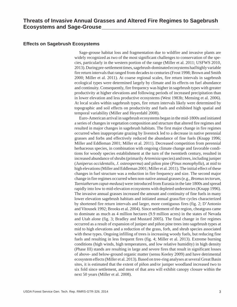
Euro-American arrival in sagebrush ecosystems began in the mid-1800s and initiated a series of changes in vegetation composition and structure that altered fire regimes and resulted in major changes in sagebrush habitats. The first major change in fire regimes occurred when inappropriate grazing by livestock led to a decrease in native perennial grasses and forbs and effectively reduced the abundance of fine fuels (Knapp 1996; Miller and Eddleman 2001; Miller et al. 2011). Decreased competition from perennial herbaceous species, in combination with ongoing climate change and favorable condi-tions for woody species establishment at the turn of the twentieth century, resulted in increased abundance of shrubs (primarily Artemisia species) and trees, including juniper (Juniperus occidentalis, J. osteosperma) and piñon pine (Pinus monophylla), at mid to high elevations (Miller and Eddleman 2001; Miller et al. 2011). The initial effect of these changes in fuel structure was a reduction in fire frequency and size. The second major change in fire regimes occurred when non-native annual grasses (e.g., Bromus tectorum, Taeniatherum caput-medusa) were introduced from Eurasia in the late 1800s and spread rapidly into low to mid-elevation ecosystems with depleted understories (Knapp 1996). The invasive annual grasses increased the amount and continuity of fine fuels in many lower elevation sagebrush habitats and initiated annual grass/fire cycles characterized by shortened fire return intervals and larger, more contiguous fires (fig. 2; D’Antonio and Vitousek 1992; Brooks et al. 2004). Since settlement of the region, cheatgrass came to dominate as much as 4 million hectares (9.9 million acres) in the states of Nevada and Utah alone (fig. 3; Bradley and Mustard 2005). The final change in fire regimes occurred as a result of expansion of juniper and piñon pine trees into sagebrush types at mid to high elevations and a reduction of the grass, forb, and shrub species associated with these types. Ongoing infilling of trees is increasing woody fuels, but reducing fine fuels and resulting in less frequent fires (fig. 4; Miller et al. 2013). Extreme burning conditions (high winds, high temperatures, and low relative humidity) in high density (Phase III) stands are resulting in large and severe fires that result in significant losses of above- and below-ground organic matter (sensu Keeley 2009) and have detrimental ecosystem effects (Miller et al. 2013). Based on tree-ring analyses at several Great Basin sites, it is estimated that the extent of piñon and/or juniper woodland increased two to six fold since settlement, and most of that area will exhibit canopy closure within the next 50 years (Miller et al. 2008).
4 USDA Forest Service Gen. Tech. Rep. RMRS-GTR-326. 2014
Figure 2. A wildfire that burned through a Wyoming big sagebrush ecosystem with an invasive annual grass understory in southern Idaho (top) (photo by Douglas J. Shinneman), and a close-up of a fire in a Wyoming big sagebrush ecosystem (bottom) (photo by Scott Schaff).

5USDA Forest Service Gen. Tech. Rep. RMRS-GTR-326. 2014
Figure 3. A wildfire that started in invasive annual grass adjacent to a railroad track and burned upslope into a mountain big sagebrush and Jeffrey pine ecosystem in northeast Nevada (top). A big sagebrush ecosystem that has been converted to invasive annual grass in north central Nevada (bottom) (photos by Nolan E. Preece).

6 USDA Forest Service Gen. Tech. Rep. RMRS-GTR-326. 2014
Figure 4. Expansion of Utah juniper trees into a mountain big sagebrush ecosystem in east central Utah (top) that is resulting in progressive infilling of the trees and exclusion of native understory spe-cies (bottom) (photos by Bruce A. Roundy).
7USDA Forest Service Gen. Tech. Rep. RMRS-GTR-326. 2014
Effects on Sage-Grouse Habitat Selection and Population Dynamics
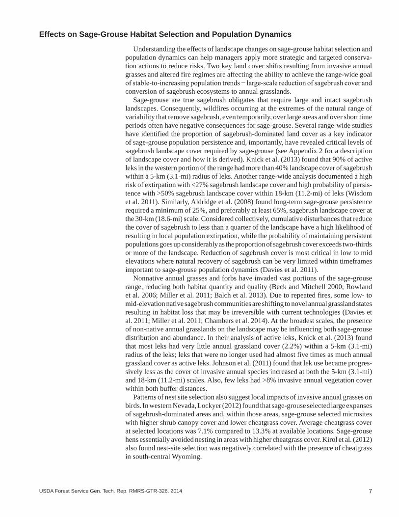
Understanding the effects of landscape changes on sage-grouse habitat selection and population dynamics can help managers apply more strategic and targeted conserva-tion actions to reduce risks. Two key land cover shifts resulting from invasive annual grasses and altered fire regimes are affecting the ability to achieve the range-wide goal of stable-to-increasing population trends − large-scale reduction of sagebrush cover and conversion of sagebrush ecosystems to annual grasslands.
Sage-grouse are true sagebrush obligates that require large and intact sagebrush landscapes. Consequently, wildfires occurring at the extremes of the natural range of variability that remove sagebrush, even temporarily, over large areas and over short time periods often have negative consequences for sage-grouse. Several range-wide studies have identified the proportion of sagebrush-dominated land cover as a key indicator of sage-grouse population persistence and, importantly, have revealed critical levels of sagebrush landscape cover required by sage-grouse (see Appendix 2 for a description of landscape cover and how it is derived). Knick et al. (2013) found that 90% of active leks in the western portion of the range had more than 40% landscape cover of sagebrush within a 5-km (3.1-mi) radius of leks. Another range-wide analysis documented a high risk of extirpation with <27% sagebrush landscape cover and high probability of persis-tence with >50% sagebrush landscape cover within 18-km (11.2-mi) of leks (Wisdom et al. 2011). Similarly, Aldridge et al. (2008) found long-term sage-grouse persistence required a minimum of 25%, and preferably at least 65%, sagebrush landscape cover at the 30-km (18.6-mi) scale. Considered collectively, cumulative disturbances that reduce the cover of sagebrush to less than a quarter of the landscape have a high likelihood of resulting in local population extirpation, while the probability of maintaining persistent populations goes up considerably as the proportion of sagebrush cover exceeds two-thirds or more of the landscape. Reduction of sagebrush cover is most critical in low to mid elevations where natural recovery of sagebrush can be very limited within timeframes important to sage-grouse population dynamics (Davies et al. 2011).
Nonnative annual grasses and forbs have invaded vast portions of the sage-grouse range, reducing both habitat quantity and quality (Beck and Mitchell 2000; Rowland et al. 2006; Miller et al. 2011; Balch et al. 2013). Due to repeated fires, some low- to mid-elevation native sagebrush communities are shifting to novel annual grassland states resulting in habitat loss that may be irreversible with current technologies (Davies et al. 2011; Miller et al. 2011; Chambers et al. 2014). At the broadest scales, the presence of non-native annual grasslands on the landscape may be influencing both sage-grouse distribution and abundance. In their analysis of active leks, Knick et al. (2013) found that most leks had very little annual grassland cover (2.2%) within a 5-km (3.1-mi) radius of the leks; leks that were no longer used had almost five times as much annual grassland cover as active leks. Johnson et al. (2011) found that lek use became progres-sively less as the cover of invasive annual species increased at both the 5-km (3.1-mi) and 18-km (11.2-mi) scales. Also, few leks had >8% invasive annual vegetation cover within both buffer distances.
Patterns of nest site selection also suggest local impacts of invasive annual grasses on birds. In western Nevada, Lockyer (2012) found that sage-grouse selected large expanses of sagebrush-dominated areas and, within those areas, sage-grouse selected microsites with higher shrub canopy cover and lower cheatgrass cover. Average cheatgrass cover at selected locations was 7.1% compared to 13.3% at available locations. Sage-grouse hens essentially avoided nesting in areas with higher cheatgrass cover. Kirol et al. (2012) also found nest-site selection was negatively correlated with the presence of cheatgrass in south-central Wyoming.
8 USDA Forest Service Gen. Tech. Rep. RMRS-GTR-326. 2014
Sage-grouse population demographic studies in northern Nevada show that recruit-ment and annual survival also are affected by presence of annual grasslands at larger scales. Blomberg et al. (2012) analyzed land cover within a 5-km (3.1-mi) radius of leks and found that leks impacted by annual grasslands experienced lower recruitment than non-impacted leks, even following years of high precipitation. Leks that were not affected by invasive annual grasslands exhibited recruitment rates nearly twice as high as the population average and nearly six times greater than affected leks during years of high precipitation.
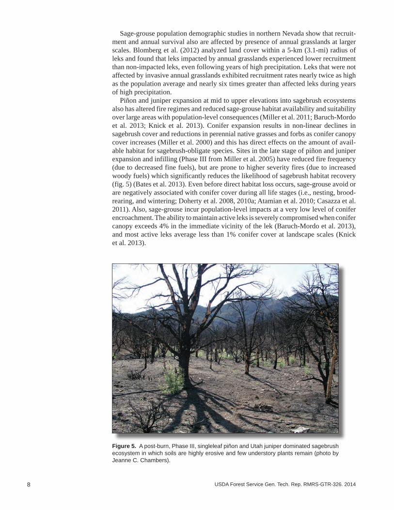
Piñon and juniper expansion at mid to upper elevations into sagebrush ecosystems also has altered fire regimes and reduced sage-grouse habitat availability and suitability over large areas with population-level consequences (Miller et al. 2011; Baruch-Mordo et al. 2013; Knick et al. 2013). Conifer expansion results in non-linear declines in sagebrush cover and reductions in perennial native grasses and forbs as conifer canopy cover increases (Miller et al. 2000) and this has direct effects on the amount of avail-able habitat for sagebrush-obligate species. Sites in the late stage of piñon and juniper expansion and infilling (Phase III from Miller et al. 2005) have reduced fire frequency (due to decreased fine fuels), but are prone to higher severity fires (due to increased woody fuels) which significantly reduces the likelihood of sagebrush habitat recovery (fig. 5) (Bates et al. 2013). Even before direct habitat loss occurs, sage-grouse avoid or are negatively associated with conifer cover during all life stages (i.e., nesting, brood-rearing, and wintering; Doherty et al. 2008, 2010a; Atamian et al. 2010; Casazza et al. 2011). Also, sage-grouse incur population-level impacts at a very low level of conifer encroachment. The ability to maintain active leks is severely compromised when conifer canopy exceeds 4% in the immediate vicinity of the lek (Baruch-Mordo et al. 2013), and most active leks average less than 1% conifer cover at landscape scales (Knick et al. 2013).
Figure 5. A post-burn, Phase III, singleleaf piñon and Utah juniper dominated sagebrush ecosystem in which soils are highly erosive and few understory plants remain (photo by Jeanne C. Chambers).
9USDA Forest Service Gen. Tech. Rep. RMRS-GTR-326. 2014
Resilience to Disturbance and Resistance to Invasive Annual Grasses in Sagebrush Ecosystems ____________________________________________
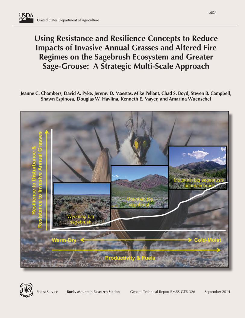
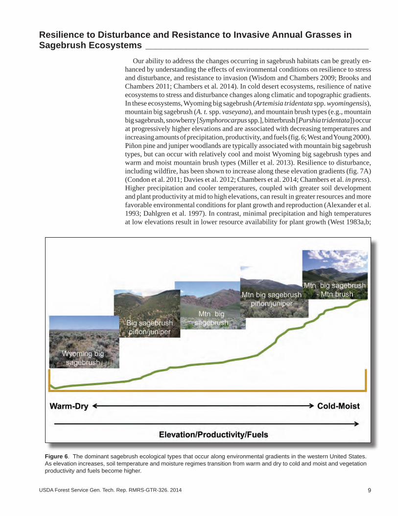
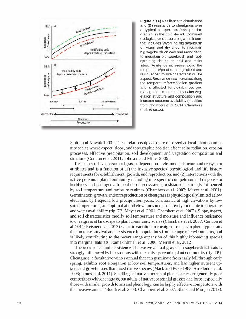
Our ability to address the changes occurring in sagebrush habitats can be greatly en-hanced by understanding the effects of environmental conditions on resilience to stress and disturbance, and resistance to invasion (Wisdom and Chambers 2009; Brooks and Chambers 2011; Chambers et al. 2014). In cold desert ecosystems, resilience of native ecosystems to stress and disturbance changes along climatic and topographic gradients. In these ecosystems, Wyoming big sagebrush (Artemisia tridentata spp. wyomingensis), mountain big sagebrush (A. t. spp. vaseyana), and mountain brush types (e.g., mountain big sagebrush, snowberry [Symphorocarpus spp.], bitterbrush [Purshia tridentata]) occur at progressively higher elevations and are associated with decreasing temperatures and increasing amounts of precipitation, productivity, and fuels (fig. 6; West and Young 2000). Piñon pine and juniper woodlands are typically associated with mountain big sagebrush types, but can occur with relatively cool and moist Wyoming big sagebrush types and warm and moist mountain brush types (Miller et al. 2013). Resilience to disturbance, including wildfire, has been shown to increase along these elevation gradients (fig. 7A) (Condon et al. 2011; Davies et al. 2012; Chambers et al. 2014; Chambers et al. in press). Higher precipitation and cooler temperatures, coupled with greater soil development and plant productivity at mid to high elevations, can result in greater resources and more favorable environmental conditions for plant growth and reproduction (Alexander et al. 1993; Dahlgren et al. 1997). In contrast, minimal precipitation and high temperatures at low elevations result in lower resource availability for plant growth (West 1983a,b;
Figure 6. The dominant sagebrush ecological types that occur along environmental gradients in the western United States. As elevation increases, soil temperature and moisture regimes transition from warm and dry to cold and moist and vegetation productivity and fuels become higher.
10 USDA Forest Service Gen. Tech. Rep. RMRS-GTR-326. 2014
Figure 7. (A) Resilience to disturbance and (B) resistance to cheatgrass over a typical temperature/precipitation gradient in the cold desert. Dominant ecological sites occur along a continuum that includes Wyoming big sagebrush on warm and dry sites, to mountain big sagebrush on cool and moist sites, to mountain big sagebrush and root-sprouting shrubs on cold and moist sites. Resilience increases along the temperature/precipitation gradient and is influenced by site characteristics like aspect. Resistance also increases along the temperature/precipitation gradient and is affected by disturbances and management treatments that alter veg-etation structure and composition and increase resource availability (modified from Chambers et al. 2014; Chambers et al. in press).
Smith and Nowak 1990). These relationships also are observed at local plant commu-nity scales where aspect, slope, and topographic position affect solar radiation, erosion processes, effective precipitation, soil development and vegetation composition and structure (Condon et al. 2011; Johnson and Miller 2006).
Resistance to invasive annual grasses depends on environmental factors and ecosystem attributes and is a function of (1) the invasive species’ physiological and life history requirements for establishment, growth, and reproduction, and (2) interactions with the native perennial plant community including interspecific competition and response to herbivory and pathogens. In cold desert ecosystems, resistance is strongly influenced by soil temperature and moisture regimes (Chambers et al. 2007; Meyer et al. 2001). Germination, growth, and/or reproduction of cheatgrass is physiologically limited at low elevations by frequent, low precipitation years, constrained at high elevations by low soil temperatures, and optimal at mid elevations under relatively moderate temperature and water availability (fig. 7B; Meyer et al. 2001; Chambers et al. 2007). Slope, aspect, and soil characteristics modify soil temperature and moisture and influence resistance to cheatgrass at landscape to plant community scales (Chambers et al. 2007; Condon et al. 2011; Reisner et al. 2013). Genetic variation in cheatgrass results in phenotypic traits that increase survival and persistence in populations from a range of environments, and is likely contributing to the recent range expansion of this highly inbreeding species into marginal habitats (Ramakrishnan et al. 2006; Merrill et al. 2012).
The occurrence and persistence of invasive annual grasses in sagebrush habitats is strongly influenced by interactions with the native perennial plant community (fig. 7B). Cheatgrass, a facultative winter annual that can germinate from early fall through early spring, exhibits root elongation at low soil temperatures, and has higher nutrient up-take and growth rates than most native species (Mack and Pyke 1983; Arredondo et al. 1998; James et al. 2011). Seedlings of native, perennial plant species are generally poor competitors with cheatgrass, but adults of native, perennial grasses and forbs, especially those with similar growth forms and phenology, can be highly effective competitors with the invasive annual (Booth et al. 2003; Chambers et al. 2007; Blank and Morgan 2012).
11USDA Forest Service Gen. Tech. Rep. RMRS-GTR-326. 2014
Also, biological soil crusts, which are an important component of plant communities in warmer and drier sagebrush ecosystems, can reduce germination or establishment of cheatgrass (Eckert et al. 1986; Kaltenecker et al. 1999). Disturbances or management treatments that reduce abundance of native perennial plants and biological soil crusts and increase the distances between perennial plants often are associated with higher resource availability and increased competitive ability of cheatgrass (Chambers et al. 2007; Reisner et al. 2013; Roundy et al. in press).
The type, characteristics, and natural range of variability of stress and disturbance strongly influence both resilience and resistance (Jackson 2006). Disturbances like overgrazing of perennial plants by livestock, wild horses, and burros and more fre-quent or more severe fires are typically outside of the natural range of conditions and can reduce the resilience of sagebrush ecosystems. Reduced resilience is triggered by changes in environmental factors like temperature regimes, abiotic attributes like water and nutrient availability, and biotic attributes such as vegetation structure, composition, and productivity (Chambers et al. 2014) and cover of biological soil crusts (Reisner et al. 2013). Resistance to an invasive species can change when changes in abiotic and biotic attributes result in increased resource availability or altered habitat suitability that influences an invasive species’ ability to establish and persist and/or compete with native species. Progressive losses of resilience and resistance can result in the crossing of abiotic and/or biotic thresholds and an inability of the system to recover to the refer-ence state (Beisner et al. 2003; Seastedt et al. 2008).
Interactions among disturbances and stressors may have cumulative effects (Chambers et al. 2014). Climate change already may be shifting fire regimes outside of the natural range of occurrence (i.e., longer wildfire seasons with more frequent and longer duration wildfires) (Westerling et al. 2006). Sagebrush ecosystems generally have low productiv-ity, and the largest number of acres burned often occurs a year or two after warm, wet conditions in winter and spring that result in higher fine fuel loads (Littell et al. 2009). Thus, annual grass fire cycles may be promoted by warm, wet winters and a subsequent increase in establishment and growth of invasive winter annuals. These cycles may be exacerbated by rising atmospheric CO2 concentrations, N deposition, and increases in human activities that result in soil surface disturbance and invasion corridors (Chambers et al. 2014). Modern deviations from historic conditions will likely continue to alter disturbance regimes and sagebrush ecosystem response to disturbances; thus, manage-ment strategies that rely on returning to historical or “pre-settlement” conditions may be insufficient, or even misguided, given novel ecosystem dynamics (Davies et al. 2009).
Integrating Resilience and Resistance Concepts With Sage-Grouse Habitat Requirements to Manage Wildfire and Invasive Annual Grass Threats at Landscape Scales _________________________________________________
The changes in sagebrush ecosystem dynamics due to invasive annual species and longer, hotter, and drier fire seasons due to a warming climate make it unlikely that these threats can be ameliorated completely (Abatzoglou and Kolden 2011; USFWS 2013). Consequently, a strategic approach is necessary to conserve sagebrush habitat and sage-grouse (Wisdom et al. 2005; Meinke et al. 2009; Wisdom and Chambers 2009; Pyke 2011). This strategic approach requires the ability to (1) identify those locations that provide current or potential habitat for sage-grouse and (2) prioritize management actions based on the capacity of the ecosystem to respond in the desired manner and to effectively allocate resources to achieve desired objectives. Current understanding of the relationship of landscape cover of sagebrush to sage-grouse habitat provides the capacity to identify those locations on the landscape that have a high probability of

12 USDA Forest Service Gen. Tech. Rep. RMRS-GTR-326. 2014
sage-grouse persistence (Aldridge et al. 2008; Wisdom et al. 2011; Knick et al. 2013). Similarly, knowledge of the relationships of environmental characteristics, specifically soil temperature and moisture regimes, to ecological types and their inherent resilience and resistance gives us the capacity to prioritize management actions based on probable effectiveness of those actions (Wisdom and Chambers 2009; Brooks and Chambers 2011; Miller et al. 2013; Chambers et al. 2014; Chambers et al. in press,).
In this section, we discuss the use of landscape cover of sagebrush as an indicator of sage-grouse habitat, and the use of soil temperature and moisture regimes as an indicator of resilience to disturbance, resistance to invasive annual grasses and, ultimately, the capacity to achieve desired objectives. We then show how these two concepts can be coupled in a sage-grouse habitat matrix and used to determine potential management strategies at the landscape scales on which sage-grouse depends.
Landscape Cover of Sagebrush as an Indicator of Sage-Grouse Habitat
Landscape cover of sagebrush is closely related to the probability of maintaining active sage-grouse leks, and is used as one of the primary indicators of sage-grouse habitat potential at landscape scales (Aldridge et al. 2008; Wisdom et al. 2011; Knick et al. 2013). Landscape cover of sagebrush less than about 25% has a low probability of sustaining active sage-grouse leks (Aldridge et al. 2008; Wisdom et al. 2011; Knick et al. 2013). Above 25% landscape cover of sagebrush, the probability of maintaining ac-tive sage-grouse leks increases with increasing sagebrush landscape cover. At landscape cover of sagebrush ranging from 50 to 85%, the probability of sustaining sage-grouse leks becomes relatively constant (Aldridge et al. 2008; Wisdom et al. 2011; Knick et al. 2013). For purposes of prioritizing landscapes for sage-grouse habitat management, we use 25% as the level below which there is a low probability of maintaining sage-grouse leks and 65% as the level above which there is little additional increase in the probability of sustaining active leks with further increases of landscape cover of sagebrush (fig. 8; Knick et al. 2013). Between about 25% and 65% landscape sagebrush cover, increases in landscape cover of sagebrush have a constant positive relationship with sage-grouse lek probability (fig. 8; Knick et al. 2013). Restoration and management activities that result in an increase in the amount of sagebrush dominated landscape within areas of pre-existing landscape cover between 25% and 65% likely will result in a higher prob-ability of sage-grouse persistence, while declines in landscape cover of sagebrush likely will result in reductions in sage-grouse (Knick et al. 2013). It is important to note that
Figure 8. The proportion of sage-grouse leks and habitat similarity index (HSI) as related to the percent landscape cover of sagebrush. The HSI indicates the relationship of environmental variables at map locations across the western portion of the range to minimum requirements for sage-grouse defined by land cover, an-thropogenic variables, soil, topography, and climate. HSI is the solid black line ± 1 SD (stippled lines). Proportion of leks are the grey bars. Dashed line indicates HSI values above which characterizes 90% of active leks (0.22). The categories at the top of the figure and the interpretation of lek persistence were added based on Aldridge et al. 2008; Wisdom et al. 2011; and Knick et al. 2013 (figure modified from Knick et al. 2013).

13USDA Forest Service Gen. Tech. Rep. RMRS-GTR-326. 2014
these data and interpretations relate only to persistence (i.e., whether or not a lek remains active) and it is likely that higher proportions of sagebrush cover or improved condition of sagebrush ecosystems may be required for population growth.
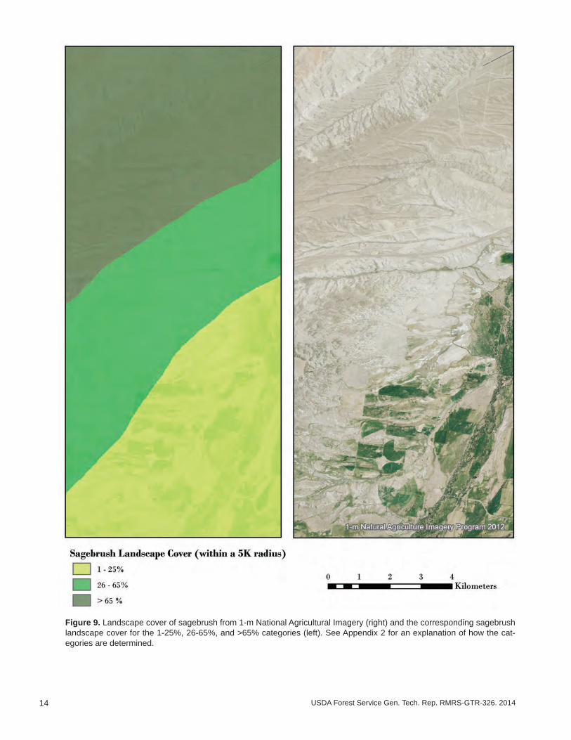
For the purposes of delineating sagebrush habitat relative to sage-grouse requirements for landscape cover of sagebrush, we calculated the percentage landscape sagebrush cover within each of the selected categories (1-25%, 26-65%, >65%) for the range of sage-grouse (fig. 9, 10). An explanation of how landscape cover of sagebrush is derived is in Appendix 2. Large areas of landscape sagebrush cover >65% are found primarily in Management Zones (MZ) II (Wyoming Basin), IV (Snake River Plains), and V (Northern Great Basin). In contrast, relatively small areas of landscape sagebrush cover >65% are located in MZ I (Great Plains), III (Southern Great Basin), VI (Columbia Basin), and VII (Colorado Plateau). Sagebrush is naturally less common in the Great Plains region compared to other parts of the range and previous work suggested that sage-grouse populations in MZ I may be more vulnerable to extirpation with further reductions in sagebrush cover (Wisdom et al. 2011). In the western portion of the range, where the threat of invasive annual grasses and wildfire is greatest, the area of sagebrush cover >65% differs among MZs. MZ III is a relatively arid and topographically diverse area in which the greatest extent of sagebrush cover >65% is in higher elevation, mountainous areas. MZs IV and V have relatively large extents of sagebrush cover >65% in relatively cooler and wetter areas, and MZs IV and VI have lower extents of sagebrush cover >65% in warmer and dryer areas and in areas with significant agricultural development. These differences in landscape cover of sagebrush indicate that different sets of management strategies may apply to the various MZs.
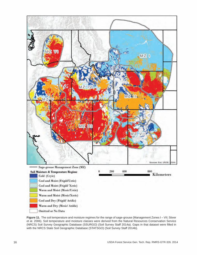
Soil Temperature and Moisture Regimes as Indicators of Ecosystem Resilience and Resistance
Potential resilience and resistance to invasive annual grasses reflect the biophysical conditions that an area is capable of supporting. In general, the highest potential resil-ience and resistance occur with cool to cold (frigid to cryic) soil temperature regimes and relatively moist (xeric to ustic) soil moisture regimes, while the lowest potential resilience and resistance occur with warm (mesic) soil temperatures and relatively dry (aridic) soil moisture regimes (Chambers et al. 2014, Chambers et al. in press). Defini-tions of soil temperature and moisture regimes are in Appendix 3. Productivity is elevated by high soil moisture and thus resilience is increased (Chambers et al. 2014); annual grass growth and reproduction is limited by cold soil temperatures and thus resistance is increased (Chambers et al. 2007). The timing of precipitation also is important be-cause cheatgrass and many other invasive annual grasses are particularly well-adapted to Mediterranean type climates with cool and wet winters and warm and dry summers (Bradford and Lauenroth 2006; Bradley 2009). In contrast, areas that receive regular summer precipitation (ustic soil moisture regimes) often are dominated by warm and/or cool season grasses (Sala et al. 1997) that likely create a more competitive environ-ment and result in greater resistance to annual grass invasion and spread (Bradford and Lauenroth 2006; Bradley 2009).
Much of the remaining sage-grouse habitat in MZs I (Great Plains), II (Wyoming Basin), VII (Colorado Plateau), and cool-to-cold or moist sites scattered across the range, are characterized by moderate to high resilience and resistance as indicated by soil temperature and moisture regimes (fig. 11). Sagebrush habitats across MZ I are unique from a range-wide perspective because soils are predominantly cool and ustic, or bordering on ustic as a result of summer precipitation; this soil moisture regime appears to result in higher resilience and resistance (Bradford and Lauenroth 2006).
14 USDA Forest Service Gen. Tech. Rep. RMRS-GTR-326. 2014
Figure 9. Landscape cover of sagebrush from 1-m National Agricultural Imagery (right) and the corresponding sagebrush landscape cover for the 1-25%, 26-65%, and >65% categories (left). See Appendix 2 for an explanation of how the cat-egories are determined.

15USDA Forest Service Gen. Tech. Rep. RMRS-GTR-326. 2014
Figure 10. The landscape cover of sagebrush within each of three selected categories (1-25%, 26-65%, >65%) for the range of sage-grouse (Management Zones I – VII; Stiver et al. 2006). The proportion of sagebrush (USGS 2013) within each of the categories in a 5-km (3.1-mi) radius surrounding each pixel was calculated relative to other land cover types for locations with sagebrush cover.
16 USDA Forest Service Gen. Tech. Rep. RMRS-GTR-326. 2014
Figure 11. The soil temperature and moisture regimes for the range of sage-grouse (Management Zones I – VII; Stiver et al. 2006). Soil temperature and moisture classes were derived from the Natural Resources Conservation Service (NRCS) Soil Survey Geographic Database (SSURGO) (Soil Survey Staff 2014a). Gaps in that dataset were filled in with the NRCS State Soil Geographic Database (STATSGO) (Soil Survey Staff 2014b).

17USDA Forest Service Gen. Tech. Rep. RMRS-GTR-326. 2014
However, significant portions of MZs III (Southern Great Basin), much of IV (Snake River Plains), V (Northern Great Basin), and VI (Columbia Basin) are characterized largely by either warm and dry, or warm to cool and moist ecological types with moder-ate to low resilience and resistance (fig. 11; table 1). Areas within these MZs that have warm and dry soils are typically characterized by Wyoming big sagebrush ecosystems with low to moderately low resilience and resistance and are currently of greatest con-cern for sage-grouse conservation (fig. 12A). Areas with warm to cool soil temperature regimes and moist precipitation regimes are typically characterized by either Wyoming or mountain big sagebrush, have moderate to moderately low resilience and resistance,
Table 1. Predominant sagebrush ecological types in Sage-Grouse Management Zones III, IV, V, and VI based on soil tempera-ture and soil moisture regimes, typical characteristics, and resilience to disturbance and resistance to invasive annual grasses (modified from Miller et al. 2014 a,b). Relative abundance of sagebrush species and composition of understory vegetation vary depending on Major Land Resource Area and ecological site type.
Ecological type Characteristics Resilience and resistanceCold and Moist(Cryic/Xeric)
Ppt: 14 inches +Typical shrubs: Mountain big sagebrush, snowfield sagebrush, snowberry, ser-viceberry, silver sagebrush, and/or low sagebrushes
Resilience – Moderately high. Precipitation and produc-tivity are generally high. Short growing seasons can de-crease resilience on coldest sites.Resistance– High. Low climate suitability to invasive an-nual grasses
Cool and Moist(Frigid/Xeric)
Ppt: 12-22 inchesTypical shrubs: Mountain big sagebrush, antelope bitterbrush, snowberry, and/or low sagebrushes
Piñon pine and juniper potentialin some areas
Resilience – Moderately high. Precipitation and productiv-ity are generally high. Decreases in site productivity, her-baceous perennial species, and ecological conditions can decrease resilience.Resistance – Moderate. Climate suitability to invasive an-nual grasses is moderate, but increases as soil tempera-tures increase.
Warm and Moist(Mesic/Xeric)
Ppt: 12-16 inchesTypical shrubs: Wyoming big sagebrush, mountain big sagebrush, Bonneville big sagebrush, and/or low sagebrushes
Piñon pine and juniper potential in some areas
Resilience – Moderate. Precipitation and productivity are moderately high. Decreases in site productivity, herba-ceous perennial species, and ecological conditions can decrease resilience.Resistance – Moderately low. Climate suitability to inva-sive annual grasses is moderately low, but increases as soil temperatures increase.
Cool and Dry(Frigid/Aridic)
Ppt: 6-12 inchesTypical shrubs: Wyoming big sagebrush, black sagebrush, and/or low sagebrushes
Resilience – Low. Effective precipitation limits site produc-tivity. Decreases in site productivity, herbaceous perennial species, and ecological conditions further decrease resil-ience.Resistance – Moderate. Climate suitability to invasive an-nual grasses is moderate, but increases as soil tempera-tures increase.
Warm and Dry (Mesic/Aridic, bordering on Xeric)
Ppt: 8-12 inchesTypical shrubs: Wyoming big sagebrush, black sagebrush and/or low sagebrushes
Resilience – Low. Effective precipitation limits site produc-tivity. Decreases in site productivity, herbaceous perennial species, and ecological conditions further decrease resil-ience. Cool season grasses susceptibility to grazing and fire, along with hot dry summer fire conditions, promote cheatgrass establishment and persistence.Resistance – Low. High climate suitability to cheatgrass and other invasive annual grasses. Resistance generally decreases as soil temperature increases, but establish-ment and growth are highly dependent on precipitation.

18 USDA Forest Service Gen. Tech. Rep. RMRS-GTR-326. 2014
and have the potential for piñon and juniper expansion (Miller et al. 2014a; Chambers et al. in press). Many of these areas also are of conservation concern because piñon and juniper expansion and tree infilling can result in progressive loss of understory species and altered fire regimes (Miller et al. 2013). In contrast, areas with cool to cold soil temperature regimes and moist precipitation regimes have moderately high resilience and high resistance and are likely to recover in a reasonable amount of time following wildfires and other disturbances (Miller et al. 2013) (fig. 12B)
Figure 12. A Wyoming big sagebrush ecosystem with warm and dry soils in southeast Oregon (top) (photo by Richard F. Miller), compared to a mountain big sagebrush ecosystem with cool and moist soils in central Nevada (bottom) (photo by Jeanne C. Chambers).

19USDA Forest Service Gen. Tech. Rep. RMRS-GTR-326. 2014
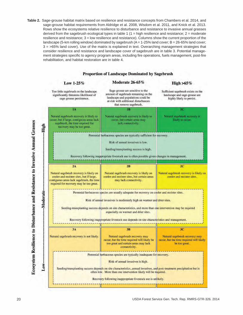
Management Strategies Based on Landscape Cover of Sagebrush and Ecosystem Resilience and Resistance: The Sage-Grouse Habitat Matrix
Knowledge of the potential resilience and resistance of sagebrush ecosystems can be used in conjunction with sage-grouse habitat requirements to determine priority areas for management and identify effective management strategies at landscape scales (Wisdom and Chambers 2009). The sage-grouse habitat matrix (table 2) illustrates the relative resilience to disturbance and resistance to invasive annual grasses of sagebrush eco-systems in relation to the proportion of sagebrush cover on the landscape. As resilience and resistance go from high to low, as indicated by the rows in the matrix, decreases in sagebrush regeneration and abundance of perennial grasses and forbs progressively limit the capacity of a sagebrush ecosystem to recover after fire or other disturbances. The risk of annual invasives increases and the ability to successfully restore burned or otherwise disturbed areas decreases. As sagebrush cover goes from low to high within these same ecosystems, as indicated by the columns in the matrix, the capacity to provide adequate habitat cover for sage-grouse increases. Areas with less than 25% landscape cover of sagebrush are unlikely to provide adequate habitat for sage-grouse; areas with 26-65% landscape cover of sagebrush can provide habitat for sage-grouse but are at risk if sagebrush loss occurs without recovery; and areas with >65% landscape cover of sagebrush provide the necessary habitat conditions for sage-grouse to persist. Potential landscape scale management strategies can be determined by considering (1) resilience to disturbance, (2) resistance to invasive annuals, and (3) sage-grouse land cover require-ments. Overarching management strategies to maintain or increase sage-grouse habitat at landscape scales based on these considerations are conservation, prevention, restoration, and monitoring and adaptive management (table 3; see Chambers et al. 2014). These strategies have been adapted for each of the primary agency programs including fire operations, fuels management, post-fire rehabilitation, and habitat restoration (table 4). Because sagebrush ecosystems occur over continuums of environmental conditions, such as soil temperature and moisture, and have differing land use histories and species composition, careful assessment of the area of concern always will be necessary to de-termine the relevance of a particular strategy (Pyke 2011; Chambers et al. 2014; Miller et al. 2014 a, b). The necessary information for conducting this type of assessment is found in the “Putting It All Together” section of this report.
Although the sage-grouse habitat matrix (table 2) can be viewed as partitioning land units into spatially discrete categories (i.e., landscapes or portions thereof can be categorized as belonging to one of nine categories), it is not meant to serve as a strict guide to spatial allocation of resources or to prescribe specific management strategies. Instead, the matrix should serve as a decision support tool for helping managers imple-ment strategies that consider both the resilience and resistance of the landscape and landscape sagebrush cover requirements of sage-grouse. For example, low elevation Wyoming big sagebrush plant communities with relatively low resilience and resistance may provide important winter habitat resources for a given sage-grouse population. In a predominantly Wyoming big sagebrush area comprised of relatively low sagebrush landscape cover, a high level of management input may be needed to realize conservation benefits for sage-grouse. This doesn’t mean that management activities should not be undertaken if critical or limiting sage-grouse habitat resources are present, but indicates that inputs will be intensive, potentially more expensive, and less likely to succeed relative to more resilient landscapes. It is up to the user of the matrix to determine how such tradeoffs influence management actions.
20 USDA Forest Service Gen. Tech. Rep. RMRS-GTR-326. 2014
Table 2. Sage-grouse habitat matrix based on resilience and resistance concepts from Chambers et al. 2014, and sage-grouse habitat requirements from Aldridge et al. 2008, Wisdom et al. 2011, and Knick et al. 2013. Rows show the ecosystems relative resilience to disturbance and resistance to invasive annual grasses derived from the sagebrush ecological types in table 1 (1 = high resilience and resistance; 2 = moderate resilience and resistance; 3 = low resilience and resistance). Columns show the current proportion of the landscape (5-km rolling window) dominated by sagebrush (A = 1-25% land cover; B = 26-65% land cover; 3 = >65% land cover). Use of the matrix is explained in text. Overarching management strategies that consider resilience and resistance and landscape cover of sagebrush are in table 3. Potential manage-ment strategies specific to agency program areas, including fire operations, fuels management, post-fire rehabilitation, and habitat restoration are in table 4.
21USDA Forest Service Gen. Tech. Rep. RMRS-GTR-326. 2014
Table 3. Potential management strategies based on resilience to disturbance, resistance to annual grass invasion, and sage-grouse habitat requirements based on Aldridge et al. 2008; Wisdom et al. 2011; and Knick et al. 2013 (adapted from Chambers et al. 2014).
Conserve – maintain or increase resilience to disturbance and resistance to invasive annuals in areas with high conservation value
Priorities • Ecosystems with low to moderate resilience to fire and resistance to invasive species that still have large patches of landscape sagebrush cover and adequate perennial grasses and forbs – ecological types with warm and dry and cool and dry soil temperature/moisture regimes.
• Ecosystems with a high probability of providing habitat for sage-grouse, especially those with >65% landscape cover of sagebrush and adequate perennial herbaceous species – all ecological types.
Objective • Minimize impacts of current and future human-caused disturbances and stressors.Activities • Immediately suppress fire in moderate to low resilience and resistance sagebrush and wooded
shrublands to prevent an invasive annual grass-fire cycle. Large sagebrush patches are high priority for protection from wildfires.
• Implement strategic fuel break networks to provide anchor points for suppression and reduce losses when wildfires escape initial attack.
• Manage livestock grazing to prevent loss of perennial native grasses and forbs and biological soil crusts and allow natural regeneration.
• Limit anthropogenic activities that cause surface disturbance, invasion, and fragmentation. (e.g., road and utility corridors, urban expansion, OHV use, and mineral/energy projects).
• Detect and control new weed infestations.
Prevent – maintain or increase resilience and resistance of areas with declining ecological conditions that are at risk of conversion to a degraded, disturbed, or invaded state
Priorities • Ecosystems with moderate to high resilience and resistance – ecological types with relatively cool and moist soil temperature and moisture regimes.
○ Prioritize landscape patches that exhibit declining conditions due to annual grass invasion and/or tree expansion (e.g., at risk phase in State and Transition Models).
• Ecosystems with a moderate to high probability of providing sage-grouse habitat, especially those with 26-65% landscape cover of sagebrush and adequate perennial native grasses and forbs – all ecological types.
Objectives • Reduce fuel loads and decrease the risk of high intensity and high severity fire. • Increase abundance of perennial native grasses and forbs and of biological soil crusts where they
naturally occur. • Decrease the longer-term risk of annual invasive grass dominance.Activities • Use mechanical treatments like cut and leave or mastication to remove trees, decrease woody fuels,
and release native grasses and forbs in warm and moist big sagebrush ecosystems with relatively low resistance to annual invasive grasses that are in the early to mid-phase of piñon and/or juniper expansion.
• Use prescribed fire or mechanical treatments to remove trees, decrease woody fuels, and release native grasses and forbs in cool and moist big sagebrush ecosystems with relatively high resistance to annual invasive grass that are in early to mid-phase of piñon and/or juniper expansion.
• Actively manage post-treatment areas to increase perennial herbaceous species and minimize secondary weed invasion.
• Consider the need for strategic fuel breaks to help constrain fire spread or otherwise augment suppression efforts.
Restore – increase resilience and resistance of disturbed, degraded, or invaded areas
Priorities • Areas burned by wildfire – all ecological types ○ Prioritize areas with low to moderate resilience and resistance, and that have a reasonable
expectation of recovery. ○ Prioritize areas where perennial grasses and forbs have been depleted. ○ Prioritize areas that experienced high severity fire.
(continued)
22 USDA Forest Service Gen. Tech. Rep. RMRS-GTR-326. 2014
• Sage-grouse habitat – all ecological types ○ Prioritize areas where restoration of sagebrush and/or perennial grasses is needed to create large
patches of landscape cover of sagebrush or connect existing patches of sagebrush habitat. ○ Prioritize areas with adequate landscape cover of sagebrush where restoration of perennial grasses
and forbs is needed. • Areas affected by anthropogenic activities that cause surface disturbance, invasion, and fragmentation.
(e.g., road and utility corridors, urban expansion, OHV use, and mineral/energy projects) – all ecological types.
Objectives • Increase soil stability and curtail dust. • Control/suppress invasive annual grasses and other invasive plants. • Increase landscape cover of sagebrush. • Increase perennial grasses and forbs and biological soil crusts where they naturally occur. • Reduce the risk of large fires that burn sage-grouse habitat.Activities • Use integrated strategies to control/suppress annual invasive grass and other annual invaders. • Establish and maintain fuel breaks or greenstrips in areas dominated by invasive annual grasses that
are adjacent to areas with >25% landscape sagebrush cover and adequate perennial native grasses and forbs.
• Seed perennial grasses and forbs that are adapted to local conditions to increase cover of these species in areas where they are depleted.
• Seed and/or transplant sagebrush to restore large patches of sagebrush cover and connect existing patches.
• Repeat restoration treatments if they fail initially to ensure restoration success especially in warm and dry soil temperature moisture regimes where weather is often problematic for establishment.
• Actively manage restored/rehabilitated areas to increase perennial herbaceous species and minimize secondary weed invasion.
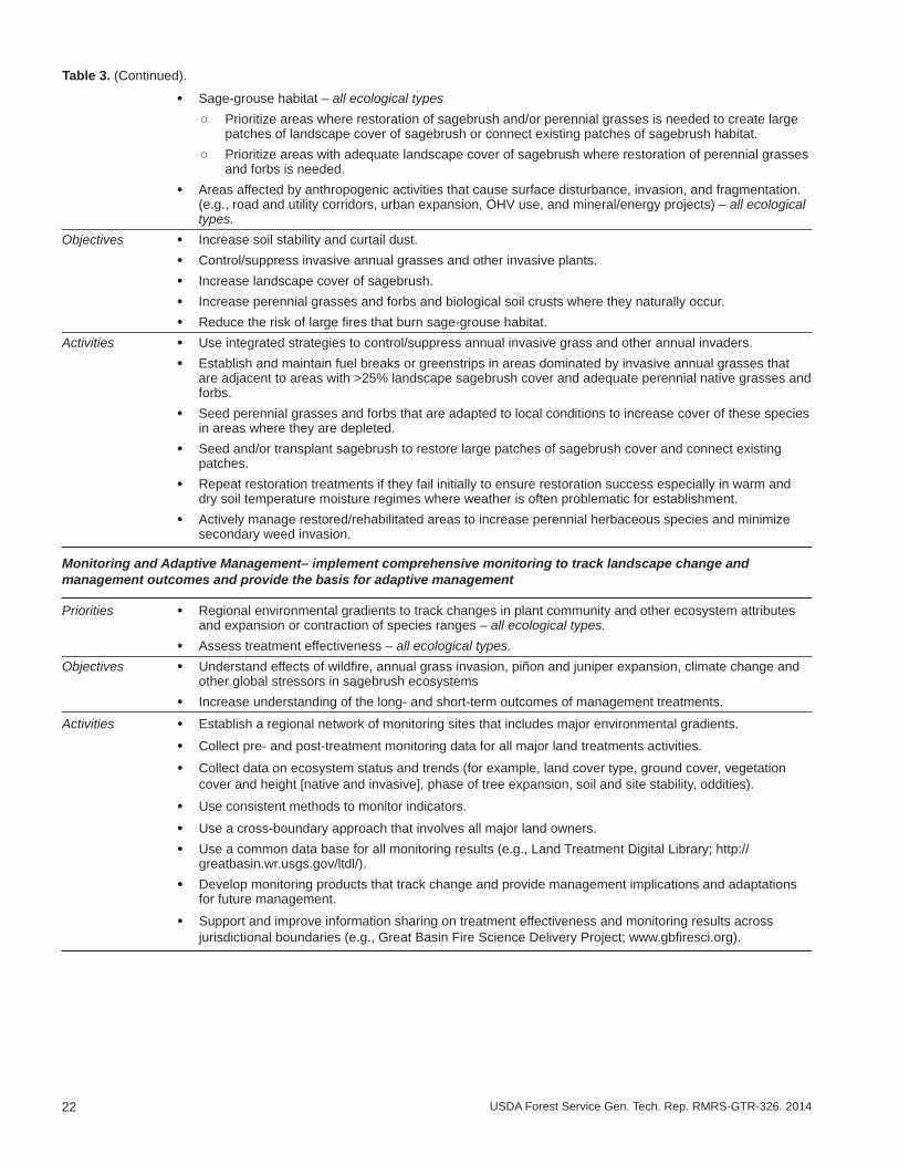
Monitoring and Adaptive Management– implement comprehensive monitoring to track landscape change and management outcomes and provide the basis for adaptive management
Priorities • Regional environmental gradients to track changes in plant community and other ecosystem attributes and expansion or contraction of species ranges – all ecological types.
• Assess treatment effectiveness – all ecological types. Objectives • Understand effects of wildfire, annual grass invasion, piñon and juniper expansion, climate change and
other global stressors in sagebrush ecosystems • Increase understanding of the long- and short-term outcomes of management treatments.
Activities • Establish a regional network of monitoring sites that includes major environmental gradients.
• Collect pre- and post-treatment monitoring data for all major land treatments activities.
• Collect data on ecosystem status and trends (for example, land cover type, ground cover, vegetation cover and height [native and invasive], phase of tree expansion, soil and site stability, oddities).
• Use consistent methods to monitor indicators.
• Use a cross-boundary approach that involves all major land owners. • Use a common data base for all monitoring results (e.g., Land Treatment Digital Library; http://
greatbasin.wr.usgs.gov/ltdl/). • Develop monitoring products that track change and provide management implications and adaptations
for future management.
• Support and improve information sharing on treatment effectiveness and monitoring results across jurisdictional boundaries (e.g., Great Basin Fire Science Delivery Project; www.gbfiresci.org).
Table 3. (Continued).
23USDA Forest Service Gen. Tech. Rep. RMRS-GTR-326. 2014
Table 4. Specific management strategies by agency program area for the cells within the sage-grouse habitat matrix (table 2). The rows indicate relative resilience and resistance (numbers) and the columns indicate landscape cover of sagebrush by category (letters). Resilience and resistance are based on soil temperature and moisture regimes (fig. 11) and their relationship to ecological types (table 1). Percentage of the landscape dominated by sagebrush is based on the capac-ity of large landscapes to support viable sage-grouse populations over the long term (fig. 8). Note that these guidelines are related to the sage-grouse habitat matrix, and do not preclude other factors from consideration when determining management priorities for program areas. The “Fire Operations” program area includes preparedness, prevention, and suppression activities.
High Resilience to Disturbance and Resistance to Invasive Annual Grasses (1A, 1B, 1C)
Natural sagebrush recovery is likely to occur. Perennial herbaceous species are sufficient for recovery. Risk of invasive annual grasses is typically low.
Fire Operations • Fire suppression is typically third order priority, but varies with large fire risk and landscape condition (cells 1A, 1B, 1C). Scenarios requiring higher priority may include:
○ Areas of sagebrush that bridge large, contiguous expanses of sagebrush and that are important for providing connectivity for sage-grouse (cells 1B, 1C).
○ Areas where sagebrush communities have been successfully reestablished through seedings or other rehabilitation investments (cells 1A, 1B, 1C)
○ Areas with later phase (Phase III) post-settlement piñon and juniper that have high resistance to control, are subject to large and/or severe fires, and place adjacent sage-grouse habitat at risk (cells 1A, 1B).
○ All areas when critical burning environment conditions exist. These conditions may be identified by a number of products including, but not limited to: Predictive Services 7-Day Significant Fire Potential Forecasts; National Weather Service Fire Weather Watches and Red Flag Warnings; fire behavior forecasts or other local knowledge.
Fuels • Fuels management to reduce large sagebrush stand losses is a second order priority, especially inManagement cells 1B and 1C. Management activities include: ○ Strategic placement of fuel breaks to reduce loss of large sagebrush stands by wildfire. Examples
include linear features or other strategically placed treatments that serve to constrain fire spread or otherwise augment suppression efforts.
○ Tree removal in early to mid-phase (Phases I, II), post-settlement piñon and juniper expansion areas to maintain shrub/herbaceous cover and reduce fuel loads.
○ Tree removal in later phase (Phase III), post-settlement piñon and juniper areas to reduce risks of large or high severity fires. Because these areas represent non-sage-grouse habitat, prescribed fire may be appropriate on cool and moist sites, but invasive plant control and restoration of sagebrush and perennial native grasses and forbs may be necessary.
Post-Fire • Post-fire rehabilitation is generally low priority (cells 1A, 1B, 1C). Areas of higher priority include:Rehabilitation ○ Areas where perennial herbaceous cover, density, and species composition is inadequate for
recovery.
○ Areas where seeding or transplanting sagebrush is needed to maintain habitat connectivity for sage-grouse.
○ Steep slopes and soils with erosion potential.
Habitat • Restoration is typically passive and designed to increase or maintain perennial herbaceous species,Restoration biological soil crusts and landscape cover of sagebrush (cells 1A, 1B, 1C). Areas to consider for activeand Recovery restoration include: ○ Areas where perennial herbaceous cover density, or composition is inadequate for recovery after
surface disturbance.
○ Areas where seeding or transplanting sagebrush is needed to maintain habitat connectivity for sage-grouse.
Moderate Resilience to Disturbance and Resistance to Invasive Annuals (2A, 2B, 2C)
Natural sagebrush recovery is likely to occur on cooler and moister sites, but the time required may be too great if large, contiguous areas lack sagebrush. Perennial herbaceous species are usually adequate for recovery on cooler and moister sites. Risk of invasive annual grasses is moderately high on warmer and drier sites.
Fire Operations • Fire suppression is typically second order priority (cells 2A, 2B, 2C). Scenarios requiring higher priority may include:
○ Areas of sagebrush that bridge large, contiguous expanses of sagebrush and that are important for providing connectivity for sage-grouse (cells 2B, 2C). (continued)

24 USDA Forest Service Gen. Tech. Rep. RMRS-GTR-326. 2014
○ Areas where sagebrush communities have been successfully reestablished through seedings or other rehabilitation investments (cells 2A, 2B, 2C)
○ Areas with later phase (Phase III), post-settlement piñon and juniper that have high resistance to control, are subject to large and/or severe fires, and place adjacent sage-grouse habitat at risk (cells 2A, 2B).
○ Areas where annual grasslands place adjacent sage-grouse habitat at risk (cell 2A).
○ All areas when critical burning environment conditions exist. These conditions may be identified by a number of products including, but not limited to: Predictive Services 7-Day Significant Fire Potential Forecasts; National Weather Service Fire Weather Watches and Red Flag Warnings; fire behavior forecasts or other local knowledge.
Fuels • Fuels management to reduce large sagebrush stand losses is a first order priority, especially in cells 2BManagement and 2C. Management activities include: ○ Strategic placement of fuel breaks to reduce loss of large sagebrush stands by wildfire. Examples
include linear features or other strategically placed treatments that serve to constrain fire spread or otherwise augment suppression efforts.
○ Tree removal in early to mid-phase (Phase I, II), post-settlement piñon and juniper expansion areas to maintain shrub/herbaceous cover and reduce fuel loads.
○ Tree removal in later phase (Phase III), post-settlement piñon and juniper areas to reduce risks of large or high severity fires. Because these areas represent non-sage-grouse habitat, prescribed fire may be appropriate on cool and moist sites, but restoration of sagebrush and perennial native grasses and forbs may be necessary.
Post-Fire • Post-fire rehabilitation is generally low priority (cells 2A, 2B, 2C) in cooler and moister areas. Areas ofRehabilitation higher priority include: ○ Areas where perennial herbaceous cover, density, and species composition is inadequate for
recovery.
○ Areas where seeding or transplanting sagebrush is needed to maintain habitat connectivity for sage-grouse.
○ Relatively warm and dry areas where annual invasives are expanding.
○ Steep slopes with erosion potential.
Habitat • Restoration is typically passive on cooler and moister areas and is designed to increase or maintainRestoration perennial herbaceous species, biological soil crusts, and landscape cover of sagebrush (cells 2A, 2B,and Recovery 2C). Areas to consider for active restoration include:
○ Areas where perennial herbaceous cover, density, and species composition is inadequate for recovery after surface disturbance.
○ Areas where seeding or transplanting sagebrush is needed to maintain habitat connectivity for sage-grouse.
○ Relatively warm and dry areas where annual invasives are expanding.
Low Resilience to Disturbance and Resistance to Invasive Annuals (3A, 3B, 3C)
Natural sagebrush recovery is not likely. Perennial herbaceous species are typically inadequate for recovery. Risk of invasive annual grasses is high.
Fire • Fire suppression priority depends on the landscape cover of sagebrush:Operations ○ Areas with <25% landscape cover of sagebrush are typically third order priority (cell 3A). These
areas may be a higher priority if they are adjacent to intact sage-grouse habitat or are essential for connectivity.
○ Areas with 26-65% landscape cover of sagebrush are typically second order priority (cell 3B). These areas are higher priority if they have intact understories and if they are adjacent to sage-grouse habitat.
○ Areas with >65% landscape cover of sagebrush are first order priority (cell 3C).
○ Areas where sagebrush communities have been successfully reestablished through seedings or other rehabilitation investments (cells 3A, 3B, 3C).
Table 4. (Continued).
(continued)
25USDA Forest Service Gen. Tech. Rep. RMRS-GTR-326. 2014
Fuels Management • Fuels management priority and management activities depend on the landscape cover of sagebrush:
○ Areas with <25% landscape cover of sagebrush are typically third order priority (cell 3A). Strategic placement of fuel breaks may be needed to reduce loss of adjacent sage-grouse habitat by wildfire. Examples include linear features or other strategically placed treatments that serve to constrain fire spread or otherwise augment suppression efforts.
○ Areas with 26-65% landscape cover of sagebrush are typically second order priority (cell 3B). These areas are higher priority if they have intact understories and if they are adjacent to sage-grouse habitat. Strategic placement of fuel breaks may be needed to reduce loss of large sagebrush stands by wildfire.
○ Areas with >65% landscape cover of sagebrush are first order priority (cell 3C). Strategic placement of fuel breaks may be needed to reduce loss of large sagebrush stands by wildfire.
○ Areas where sagebrush communities have been successfully reestablished through seedings or other rehabilitation investments (cells 3A, 3B, 3C). Strategic placement of fuel breaks may be needed to protect investments from repeated loss to wildfire.
Post-Fire • Post-fire rehabilitation priority and management activities depend on the landscape cover of sagebrush: Rehabilitation ○ Areas with <25% landscape cover of sagebrush are typically third order priority (cell 3A). Exceptions
include (1) sites that are relatively cool and moist and (2) areas adjacent to sage-grouse habitat where seeding can be used to increase connectivity and prevent annual invasive spread. In highly invaded areas, integrated strategies that include seeding of perennial herbaceous species and seeding and/or transplanting sagebrush will be required. Success will likely require more than one intervention due to low and variable precipitation.
○ Areas with 26-65% landscape cover of sagebrush are typically second order priority (cell 3B). Exceptions include (1) sites that are relatively cool and moist or that are not highly invaded, and (2) areas adjacent to sage-grouse habitat where seeding can be used to increase connectivity and prevent annual invasive spread. Seeding of perennial herbaceous species will be required where cover, density and species composition of these species is inadequate for recovery. Seeding and/or transplanting sagebrush as soon as possible is necessary for rehabilitating sage-grouse habitat. Success will likely require more than one intervention due to low and variable precipitation.
○ Areas with >65% landscape cover of sagebrush are first order priority, especially if they are part of a larger, contiguous area of sagebrush (cell 3C). Seeding of perennial herbaceous species will be required where cover, density and species composition of these species is inadequate for recovery. Seeding and/or transplanting sagebrush as soon as possible is necessary for rehabilitating sage-grouse habitat. Success will likely require more than one intervention due to low and variable precipitation.
Habitat • Restoration priority and management activities depends on the landscape cover of sagebrush: Restoration ○ Areas with <25% landscape cover of sagebrush are typically third order priority. Exceptions includeand Recovery (1) surface disturbances and (2) areas adjacent to sage-grouse habitat where seeding can be
used to prevent annual invasive spread (cell 3A). In highly invaded areas, integrated strategies that include seeding of perennial herbaceous species and seeding and/or transplanting sagebrush will be required. Success will likely require more than one intervention due to low and variable precipitation.
○ Areas with 26-65% landscape cover of sagebrush are typically second order priority (cell 3B). Exceptions include (1) surface disturbances, (2) sites that are relatively cool and moist or that are not highly invaded, and (3) areas adjacent to sage-grouse habitat where seeding can be used to increase connectivity and prevent annual invasive spread. Seeding of perennial herbaceous species may be required where cover, density and species composition of these species is inadequate. Seeding and/or transplanting sagebrush as soon as possible is necessary for restoring sage-grouse habitat. Success will likely require more than one intervention due to low and variable precipitation.
○ Areas with >65% landscape cover of sagebrush are first order priority, especially if they are part of a larger, contiguous area of sagebrush (cell 3C). Seeding of perennial herbaceous species may be required where cover, density, and species composition of these species is inadequate. Seeding and/or transplanting sagebrush as soon as possible is necessary for restoring sage-grouse habitat. Success will likely require more than one intervention due to low and variable precipitation.
Table 4. (Continued).
26 USDA Forest Service Gen. Tech. Rep. RMRS-GTR-326. 2014
Another important consideration is that ecological processes such as wildfire can occur either within or across categories in the sage-grouse habitat matrix and it is necessary to determine the appropriate spatial context when evaluating management opportuni-ties based on resilience and resistance and sage-grouse habitat. For example, if critical sage-grouse habitat occurs in close proximity to landscapes comprised mainly of annual grass-dominated plant communities, then fire risk to adjacent sage-grouse habitat can increase dramatically (Balch et al. 2013). In this scenario, management actions could include reducing the influence of invasive annual grasses with a strategic fuel break on the perimeter of intact sagebrush. Thus, management actions may have value to sustaining existing sage-grouse habitat, even if these measures are applied in locations that are currently not habitat; the spatial relationships of sagebrush and invasive annual grasses should be considered when prioritizing management actions and associated conservation measures.
Informing Wildfire and Fuels Management Strategies to Conserve Sage-Grouse __________________________________________________________
Collectively, responses to wildfires and implementation of fuels management proj-ects are important contributors to sage-grouse conservation. Resilience and resistance concepts provide a science-based background that can inform fire operations and fuels management strategies and allocation of scarce assets during periods of high fire ac-tivity. In fire operations, firefighter and public safety is the overriding objective in all decisions. In addition, land managers consider numerous other values at risk, including the Wildland-Urban Interface (WUI), habitats, and infrastructure when allocating assets and prioritizing efforts. Resilience and resistance concepts are especially relevant for evaluating tradeoffs related to current ecological conditions and rates of recovery and possible ecological consequences of different fire management activities. For example, prioritizing initial attack efforts based on ecological types and their resilience and resistance at fire locations is a possible future application of resilience and resistance concepts. Also, fire prevention efforts can be concentrated where human ignitions have commonly occurred near intact, high quality habitats that also have inherently low resilience and resistance.
Fuels management projects are often applied to (1) constrain or minimize fire spread; (2) alter species composition; (3) modify fire intensity, severity, or effects; or (4) cre-ate fuel breaks or anchor points that augment fire management efforts (fig. 13). These activities are selectively used based on the projected ecosystem response, anticipated fire patterns, and probability of success. For example, in areas that are difficult to restore due to low to moderate resilience, fuel treatments can be placed to minimize fire spread and conserve sagebrush habitat. In cooler and moister areas with moderate to high re-silience and resistance, mechanical or prescribed fire treatments may be appropriate to prevent conifer expansion and dominance. Given projected climate change and longer fire seasons across the western United States, fuels management represents a proactive approach for modifying large fire trends. Fire operations and fuels management programs contribute to a strategic, landscape approach when coupled with data that illustrate the likelihood of fire occurrence, potential fire behavior, and risk assessments (Finney et al. 2010; Oregon Department of Forestry 2013). In tandem with resilience and resistance concepts, these data can further inform fire operations and fuels management decisions.
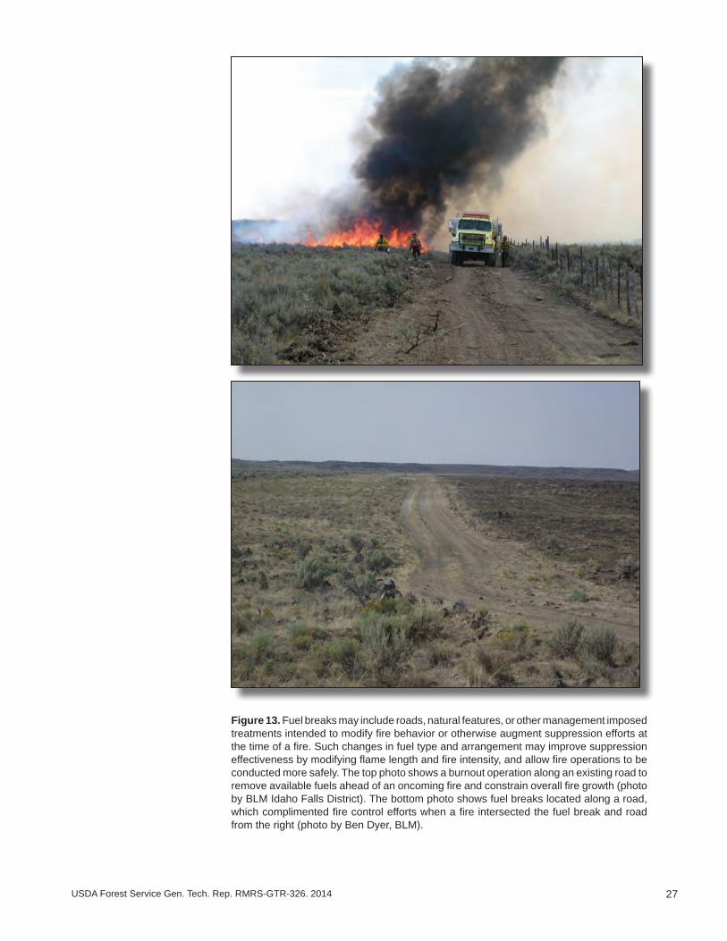
27USDA Forest Service Gen. Tech. Rep. RMRS-GTR-326. 2014
Figure 13. Fuel breaks may include roads, natural features, or other management imposed treatments intended to modify fire behavior or otherwise augment suppression efforts at the time of a fire. Such changes in fuel type and arrangement may improve suppression effectiveness by modifying flame length and fire intensity, and allow fire operations to be conducted more safely. The top photo shows a burnout operation along an existing road to remove available fuels ahead of an oncoming fire and constrain overall fire growth (photo by BLM Idaho Falls District). The bottom photo shows fuel breaks located along a road, which complimented fire control efforts when a fire intersected the fuel break and road from the right (photo by Ben Dyer, BLM).
28 USDA Forest Service Gen. Tech. Rep. RMRS-GTR-326. 2014
Putting it all Together ______________________________________________Effective management and restoration of sage-grouse habitat will benefit from a col-
laborative approach that prioritizes the best management practices in the most appropri-ate places. This section describes an approach for assessing focal areas for sage-grouse habitat management based on widely available data, including (1) Priority Areas for Conservation (PACs), (2) breeding bird densities, (3) habitat suitability as indicated by the landscape cover of sagebrush, (4) resilience and resistance and dominant ecological types as indicated by soil temperature and moisture regimes, and (5) habitat threats as indicated by cover of cheatgrass, cover of piñon and juniper, and by fire history. Breeding bird density data are overlain with landscape cover of sagebrush and with resilience and resistance to spatially link sage-grouse populations with habitat conditions and risks. We illustrate the use of this step-down approach for evaluating focal areas for sage-grouse habitat management across the western portion of the range, and we provide a detailed example for a diverse area in the northeast corner of Nevada that is comprised largely of PACs with mixed land ownership. The sage-grouse habitat matrix (table 2) is used as a tool in the decision process, and guidelines are provided to assist in determining appropriate management strategies for the primary agency program areas (fire operations, fuels management, post-fire rehabilitation, habitat restoration) for each cell of the matrix.
We conclude with discussions of the tools available to aid in determining the suit-ability of an area for treatment and the most appropriate management treatments such as ecological site descriptions and state and transition models and of monitoring and adaptive management. Datasets used to compile the maps in the following sections are in Appendix 4.
Assessing Focal Areas for Sage-Grouse Habitat Management: Key Data Layers
Priority areas for conservation: The recent identification of sage-grouse strong-holds, or Priority Areas for Conservation (PACs), greatly improves the ability to target management actions towards habitats expected to be critical for long-term viability of the species (fig. 14; USFWS 2013). Understanding and minimizing risks of large-scale loss of sagebrush and conversion to invasive annual grasses or piñon and juniper in and around PACs will be integral to maintaining sage-grouse distribution and stabilizing population trends. PACs were developed by individual states to identify those areas that are critical for ensuring adequate representation, redundance, and resilience to conserve sage-grouse populations. Methods differed among states; in general, PAC boundaries were identified based on (1) sage-grouse population data including breeding bird density, lek counts, telemetry, nesting areas, known distributions, and sightings/observations; and (2) habitat data including occupied habitat, suitable habitat, seasonal habitat, nesting and brood rearing areas, and connectivity areas or corridors. Sage-grouse habitats outside of PACs also are important in assessing focal areas for management where they provide connectivity between PACs (genetic and habitat linkages), seasonal habitats that may have been underestimated due to emphasis on lek sites to define priority areas, habitat restoration and population expansion opportunities, and flexibility for managing habitat changes that may result from climate change (USFWS 2013). If PAC boundaries are adjusted, they will need to be updated for future analyses.

29USDA Forest Service Gen. Tech. Rep. RMRS-GTR-326. 2014
Figure 14. Priority Areas for Conservation (PACs) within the range of sage-grouse (USFWS 2013). Colored polygons within Man-agement Zones delineate Priority Areas for Conservation (USFWS 2013).

30 USDA Forest Service Gen. Tech. Rep. RMRS-GTR-326. 2014
Breeding bird density: Range-wide breeding bird density areas provide one of the few accessible data sets for further prioritizing actions within and adjacent to PACs to maintain species distribution and abundance. Doherty et al. (2010b) developed a useful framework for incorporating population data in their range-wide breeding bird density analysis, which used maximum counts of males on leks (n = 4,885) to delineate breeding bird density areas that contain 25, 50, 75, and 100% of the known breeding population (fig. 15). Leks were mapped according to these abundance values and buffered by a 6.4 to 8.5 km (4.0 to 5.3 mi) radius to delineate nesting areas. Findings showed that while sage-grouse occupy extremely large landscapes, their breeding distribution is highly aggregated in comparably smaller identifiable population centers; 25% of the known population occurs within 3.9% (2.9 million ha; 7.2 million ac) of the species range, and 75% of birds are within 27.0% of the species range (20.4 million ha; 50.4 million ac) (Doherty et al. 2010b). The Doherty et al. (2010b) analysis emphasized breeding habitats primarily because little broad scale data exist for summer and winter habitat use areas. Even though the current breeding bird density data provide the most comprehensive data available, they do not include all existing sage-grouse populations. Incorporating finer scale seasonal habitat use data at local levels where it is available will ensure management actions encompass all seasonal habitat requirements.
For this assessment, we chose to use State-level breeding bird density results from Doherty et al. (2010b) instead of range-wide model results to ensure that important breeding areas in MZs III, IV, and V were not underweighted due to relatively higher bird densities in the eastern portion of the range. It is important to note that breeding density areas were identified using best available information in 2009, so these range-wide data do not reflect the most current lek count information or changes in conditions since the original analysis. Also, breeding density areas should not be viewed as rigid boundaries but rather as the means to prioritize landscapes regionally where step-down assessments and actions may be implemented quickly to conserve the most birds.
Landscape cover of sagebrush: Landscape cover of sagebrush is one of the key determinants of sage-grouse population persistence and, in combination with an under-standing of resilience to disturbance and resistance to invasive annuals, provides essential information both for determining priority areas for management and appropriate man-agement actions (fig. 10; tables 2 and 3). Landscape cover of sagebrush is a measure of large, contiguous patches of sagebrush on the landscape and is calculated from remote sensing databases such as LANDFIRE (see Appendix 4). We used the three cover cat-egories of sagebrush landscape cover discussed previously to predict the likelihood of sustaining sage-grouse populations (1-25%, 25-65%, >65%). The sagebrush landscape cover datasets were created using a moving window to summarize the proportion of area (5-km [3.1-mi] radius) dominated by sagebrush surrounding each 30-m pixel and then assigned those areas to the three categories (see Appendix 2). Because available sagebrush cover from sources such as LANDFIRE does not exclude recent fire pe-rimeters, it was necessary to either include these in the analysis of landscape cover of sagebrush or display them separately. Although areas that have burned since 2000 likely do not currently provide desired sage-grouse habitat, areas with the potential to support sagebrush ecological types can provide conservation benefits in the overall planning effort especially within long-term conservation areas like PACs. The landscape cover of sagebrush and recent fire perimeters are illustrated for the western portion of the range (fig.16) and northeast Nevada (fig. 17).

31USDA Forest Service Gen. Tech. Rep. RMRS-GTR-326. 2014
Figure 15. Range-wide sage-grouse breeding bird densities from Doherty et al. 2010. Points illustrate breeding bird density areas that contain 25, 50, 75, and 100% of the known breeding population and are based on maximum counts of males on leks (n = 4,885). Leks were mapped according to abundance values and buffered by 6.4 to 8.5 km (4.0 to 5.2 mi) to delineate nesting areas.
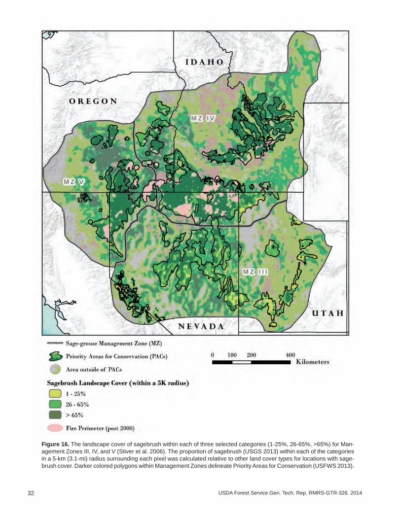
32 USDA Forest Service Gen. Tech. Rep. RMRS-GTR-326. 2014
Figure 16. The landscape cover of sagebrush within each of three selected categories (1-25%, 26-65%, >65%) for Man-agement Zones III, IV, and V (Stiver et al. 2006). The proportion of sagebrush (USGS 2013) within each of the categories in a 5-km (3.1-mi) radius surrounding each pixel was calculated relative to other land cover types for locations with sage-brush cover. Darker colored polygons within Management Zones delineate Priority Areas for Conservation (USFWS 2013).
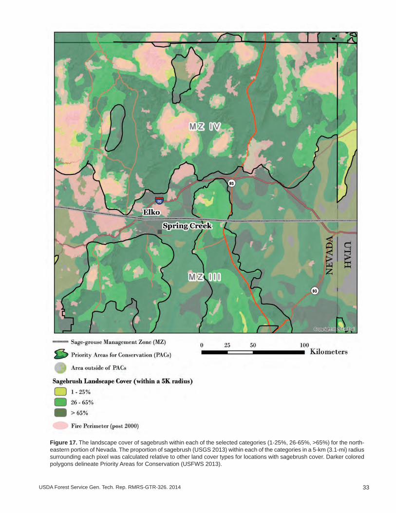
33USDA Forest Service Gen. Tech. Rep. RMRS-GTR-326. 2014
Figure 17. The landscape cover of sagebrush within each of the selected categories (1-25%, 26-65%, >65%) for the north-eastern portion of Nevada. The proportion of sagebrush (USGS 2013) within each of the categories in a 5-km (3.1-mi) radius surrounding each pixel was calculated relative to other land cover types for locations with sagebrush cover. Darker colored polygons delineate Priority Areas for Conservation (USFWS 2013).

34 USDA Forest Service Gen. Tech. Rep. RMRS-GTR-326. 2014
Resilience to disturbance and resistance to annuals: Soil temperature and mois-ture regimes are a strong indicator of ecological types and of resilience to disturbance and resistance to invasive annual plants (fig. 11; table 1). Resilience and resistance predictions coupled with landscape cover of sagebrush can provide critical informa-tion for determining focal areas for targeted management actions (tables 2, 3, and 4). The available data for the soil temperature and moisture regimes were recently com-piled to predict resilience and resistance (see Appendix 3). These data, displayed for the western portion of the range and northeast Nevada (figs. 18 and 19), illustrate the spatial variability within the focal areas. Soil temperature and moisture regimes are two of the primary determinants of ecological types and of more detailed ecological site descriptions, which are described in the section on “Determining the Most Appropriate Management Treatments at the Project Scale.”
Habitat threats: Examining additional land cover data or models of invasive an-nual grasses and piñon and/or juniper, can provide insights into the current extent of threats in a planning area (e.g., Manier et al. 2013). In addition, evaluating data on fire occurrence and size can provide information on fire history and the rate and pattern of change within the planning area. Data layers for cheatgrass cover have been derived from Landsat imagery (Peterson 2006, 2007) and from model predictions based on species occurrence, climate variables, and anthropogenic disturbance (e.g., the Bureau of Land Management [BLM] Rapid Ecoregional Assessments [REAs]). The REAs con-tain a large amount of geospatial data that may be useful in providing landscape scale information on invasive species, disturbances, and vegetation types across most of the range of sage-grouse (http://www.blm.gov/wo/st/en/prog/more/Landscape_Approach/reas.html). Similarly, geospatial data for piñon and/or juniper have been developed for various States (e.g., Nevada and Oregon) and are becoming increasingly available rangewide. In addition, more refined data products are often available at local scales. Land managers can evaluate the available land cover datasets and select those land cov-ers with the highest resolution and accuracy for the focal area. Land cover of cheatgrass and piñon and/or juniper and the fire history of the western portion of the range and northeast Nevada are in figures 20-25.
Assessing Focal Areas for Sage-Grouse Habitat Management: Integrating Data Layers
Combining resilience and resistance concepts with sage-grouse habitat and popula-tion data can help land managers further gauge relative risks across large landscapes and determine where to focus limited resources to conserve sage-grouse populations. Intersecting breeding bird density areas with soil temperature and moisture regimes provides a spatial tool to depict landscapes with high bird concentrations that may have a higher relative risk of being negatively affected by fire and annual grasses (figs. 26, 27). For prioritization purposes, areas supporting 75% of birds (6.4 to 8.5 km [4.0 to 5.2 mi] buffer around leks) can be categorized as high density while remaining breed-ing bird density areas (75-100% category; 8.5-km [5.2-mi] buffer around leks) can be categorized as low density. Similarly, warm and dry types can be categorized as having relatively low resilience to fire and resistance to invasive species and all other soil tem-perature and moisture regimes can be categorized as having relatively moderate to high resilience and resistance. Intersecting breeding bird density areas with landscape cover of sagebrush provides another spatial component revealing large and intact habitat blocks and areas in need of potential restoration to provide continued connectivity (fig. 28).

35USDA Forest Service Gen. Tech. Rep. RMRS-GTR-326. 2014
Figure 18. The soil temperature and moisture regimes within sage-grouse Management Zones III, IV, and V (Stiver et al. 2006). Soil temperature and moisture classes were derived from the Natural Resources Conservation Service (NRCS) Soil Survey Geographic Database (SSURGO) (Soil Survey Staff 2014a). Gaps in that dataset were filled in with the NRCS State Soil Geographic Database (STATSGO) (Soil Survey Staff 2014b). Darker colored polygons within Management Zones delineate Priority Areas for Conservation (USFWS 2013).
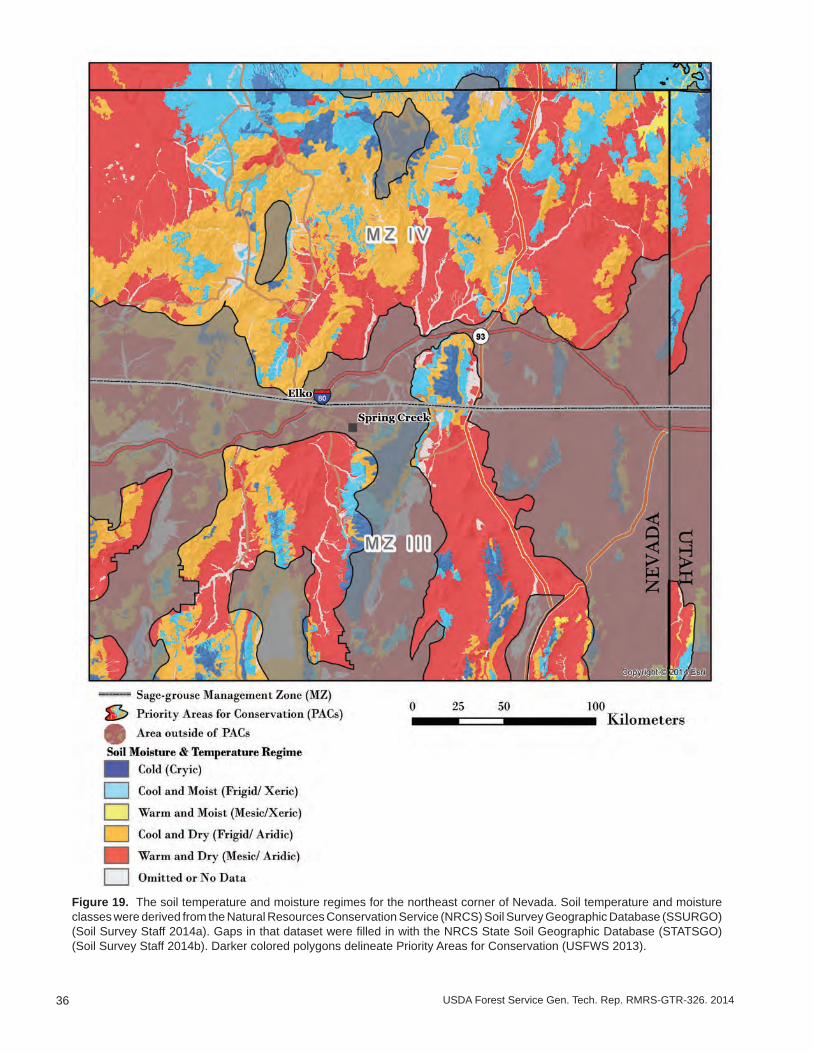
36 USDA Forest Service Gen. Tech. Rep. RMRS-GTR-326. 2014
Figure 19. The soil temperature and moisture regimes for the northeast corner of Nevada. Soil temperature and moisture classes were derived from the Natural Resources Conservation Service (NRCS) Soil Survey Geographic Database (SSURGO) (Soil Survey Staff 2014a). Gaps in that dataset were filled in with the NRCS State Soil Geographic Database (STATSGO) (Soil Survey Staff 2014b). Darker colored polygons delineate Priority Areas for Conservation (USFWS 2013).
37USDA Forest Service Gen. Tech. Rep. RMRS-GTR-326. 2014
Figure 20. Invasive annual grass index for Nevada (Peterson 2006) and the Owhyee uplands (Peterson 2007) displayed for sage-grouse Management Zones III, IV, and V (Stiver et al. 2006). Lighter colored polygons within Management Zones delineate Priority Areas for Conservation (USFWS 2013).
38 USDA Forest Service Gen. Tech. Rep. RMRS-GTR-326. 2014
Figure 21. Invasive annual grass index for Nevada (Peterson 2006) and the Owhyee uplands (Peterson 2007) displayed for the northeast corner of Nevada. Lighter colored polygons delineate Priority Areas for Conservation (USFWS 2013).

39USDA Forest Service Gen. Tech. Rep. RMRS-GTR-326. 2014
Figure 22. Piñon and/or juniper woodlands (USGS 2004; USGS 2013) within sage-grouse Management Zones III, IV, and V (Stiver et al. 2006). Lighter colored polygons within Management Zones delineate Priority Areas for Conservation (USFWS 2013).
40 USDA Forest Service Gen. Tech. Rep. RMRS-GTR-326. 2014
Figure 23. Piñon and/or juniper woodlands (USGS 2004; USGS 2013) within the northeast corner of Nevada. Lighter colored polygons delineate Priority Areas for Conservation (USFWS 2013).
41USDA Forest Service Gen. Tech. Rep. RMRS-GTR-326. 2014
Figure 24. Fire perimeters (Walters et al. 2011; Butler and Bailey 2013) within sage-grouse Management Zones III, IV, and V (Stiver et al. 2006). Ligher colored polygons within Management Zones delineate Priority Areas for Conservation (USFWS 2013).
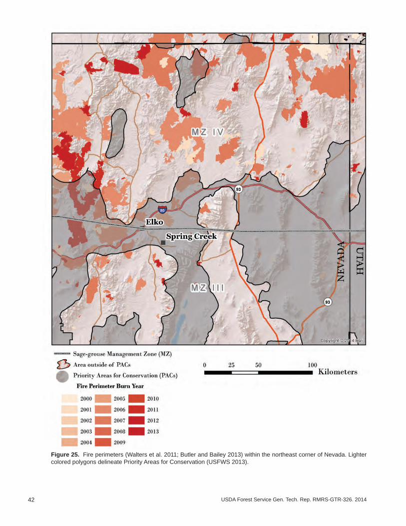
42 USDA Forest Service Gen. Tech. Rep. RMRS-GTR-326. 2014
Figure 25. Fire perimeters (Walters et al. 2011; Butler and Bailey 2013) within the northeast corner of Nevada. Lighter colored polygons delineate Priority Areas for Conservation (USFWS 2013).

43USDA Forest Service Gen. Tech. Rep. RMRS-GTR-326. 2014
Figure 26. Sage-grouse breeding bird densities (Doherty et al. 2010) for high breeding bird densities (areas that contain 75% of known breeding bird populations) and low breeding bird densities (areas that contain all remaining breeding bird populations) relative to resilience and resistance within sage-grouse Management Zones III, IV, and V (Stiver et al. 2006). Relative resilience and resistance groups are derived from soil moisture and temperature classes (Soil Survey Staff 2014a, b) as described in text, and indicate risk of invasive annual grasses and wildfire. Lighter colored polygons within Management Zones delineate Priority Areas for Conservation (USFWS 2013).
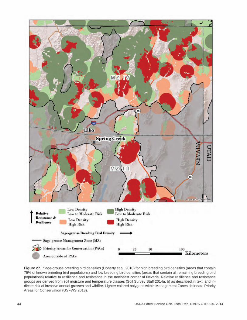
44 USDA Forest Service Gen. Tech. Rep. RMRS-GTR-326. 2014
Figure 27. Sage-grouse breeding bird densities (Doherty et al. 2010) for high breeding bird densities (areas that contain 75% of known breeding bird populations) and low breeding bird densities (areas that contain all remaining breeding bird populations) relative to resilience and resistance in the northeast corner of Nevada. Relative resilience and resistance groups are derived from soil moisture and temperature classes (Soil Survey Staff 2014a, b) as described in text, and in-dicate risk of invasive annual grasses and wildfire. Lighter colored polygons within Management Zones delineate Priority Areas for Conservation (USFWS 2013).

45USDA Forest Service Gen. Tech. Rep. RMRS-GTR-326. 2014
Figure 28. Sage-grouse breeding bird densities (Doherty et al. 2010) for high breeding bird densities (areas that contain 75% of known breeding bird populations) and low breeding bird densities (areas that contain all remaining breeding bird populations) relative to sagebrush cover. Lighter colored polygons within Management Zones delineate Priority Areas for Conservation (USFWS 2013).

46 USDA Forest Service Gen. Tech. Rep. RMRS-GTR-326. 2014
Resilience and resistance and sagebrush cover combined with bird population den-sity data provide land managers a way to evaluate trade-offs of particular management options at the landscape scale. For example, high density, low resilience and resistance landscapes with >65% sagebrush landscape cover may require immediate attention for conservation efforts because they currently support a high concentration of birds but have the lowest potential to recover to desired conditions post-fire and to resist inva-sive plants when disturbed. Similarly, high density but moderate-to-high resilience and resistance landscapes with 26-65% sagebrush cover may be priorities for preventative actions like conifer removal designed to increase the proportion of sagebrush cover and maintain ecosystem resilience and resistance. Mapping relative resilience and resistance and landscape cover of sagebrush for sage-grouse breeding areas should be viewed as a component of the assessment process that can help local managers allocate resources to accelerate planning and implementation.
Interpretations at the Management Zone (MZ) Scale: Western Portion of the Range
An examination of land cover and additional data layers for the western portion of the range reveals large differences among Management Zones (MZs) III, IV and V. MZs IV and V have larger areas with sagebrush cover >65% than MZ III (fig. 16). This may be partly explained by basin and range topography in MZ III, which is characterized by large differences in both environmental conditions and ecological types over relatively short distances. However, the cover of piñon and juniper in and adjacent to PACs in MZ III also is higher than in either MZ IV or V (fig. 22). The greater cover of piñon and juniper in MZ III appears to largely explain the smaller patches of sagebrush cover in the 26-65% and >65% categories.
Our capacity to quantify understory vegetation cover using remotely sensed data is currently limiting, but a visual examination of estimates for invasive annual grass (fig. 20; Peterson 2006, 2007) suggests a higher index (greater cover) in areas with relatively low resistance (warm soil temperatures) in all MZs (see fig. 18). This is consistent with current understanding of resistance to cheatgrass (Chambers et al. 2014; Chambers et al. in press). It is noteworthy that the invasive annual grass index is low for most of the central basin and range (central Nevada). Several factors may be contributing to the low index for this area including climate, the stage of piñon and juniper expansion and linked decrease in fire frequency, the relative lack of human development, and the relative lack of management treatments in recent decades (Wisdom et al. 2005; Miller et al. 2011). Not surprisingly, areas with a high annual grass index are outside or on the periphery of current PACs. However, it is likely that invasive annual grasses are present on many warmer sites and that they may increase following fire or other disturbances. In areas with low resistance to invasive annual grasses, they often ex-ist in the understory of sagebrush ecosystems and are not detected by remote sensing platforms such as Landsat.
The number of hectares burned has been highest in MZ IV, adjacent areas in MZ V, and in areas with relatively low resilience and resistance in the northern portion of MZ III that have a high invasive annual grass index (figs. 18, 20, 24). A total of over 1.1 million hectares (2.7 million acres) burned in 2000 and 2006, while over 1.7 million hectares (4.2 million acres) burned in 2007 and 2012 and almost three quarters of these acres were in MZ IV (table 5). In some cases, these fires appear to be linked to the annual invasive grass index, but in others it clearly is not. At this point, there appears to be little relationship between cover of piñon and juniper and wildfire. Mega-fires comprised of hundreds of thousands of acres have burned in recent years, especially in MZ IV. These fires have occurred primarily in areas with low to moderate resilience and resistance and during periods with extreme burning conditions.
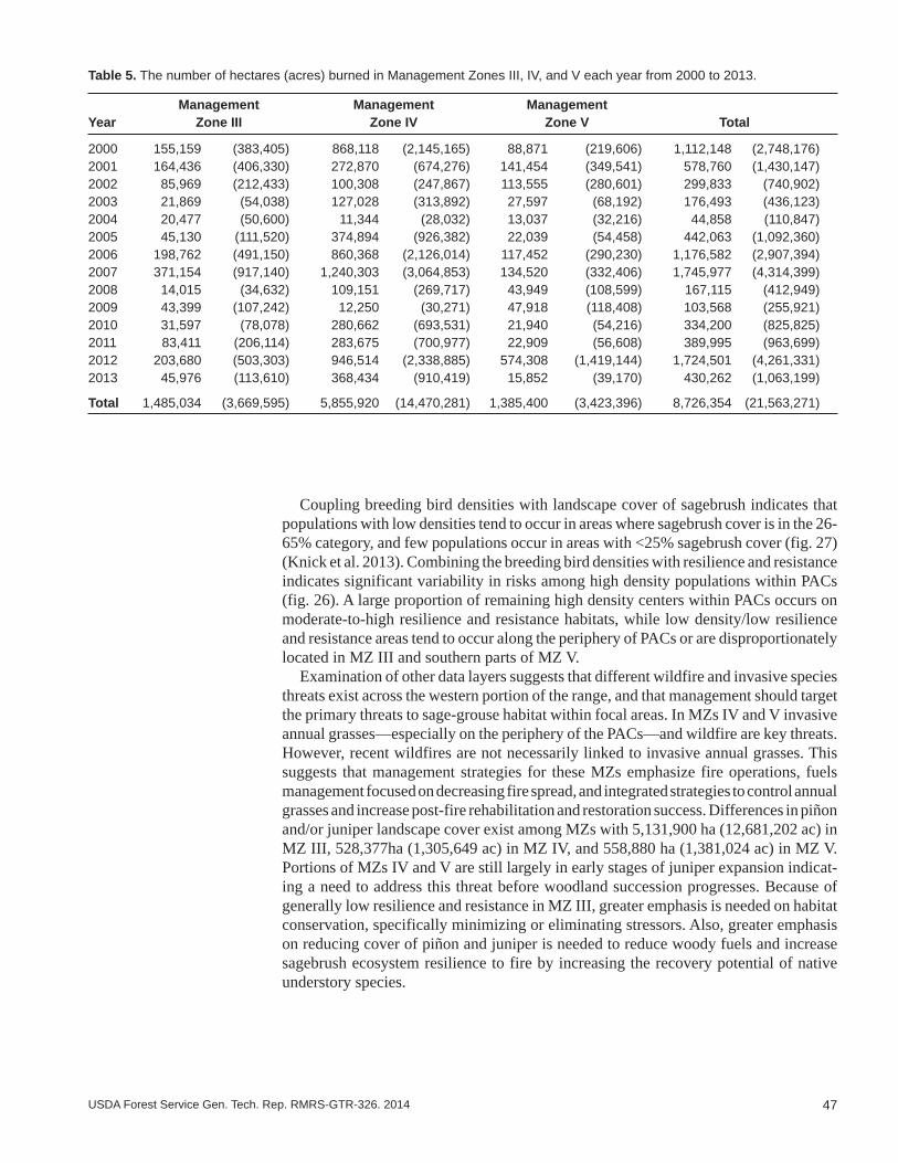
47USDA Forest Service Gen. Tech. Rep. RMRS-GTR-326. 2014
Coupling breeding bird densities with landscape cover of sagebrush indicates that populations with low densities tend to occur in areas where sagebrush cover is in the 26-65% category, and few populations occur in areas with <25% sagebrush cover (fig. 27) (Knick et al. 2013). Combining the breeding bird densities with resilience and resistance indicates significant variability in risks among high density populations within PACs (fig. 26). A large proportion of remaining high density centers within PACs occurs on moderate-to-high resilience and resistance habitats, while low density/low resilience and resistance areas tend to occur along the periphery of PACs or are disproportionately located in MZ III and southern parts of MZ V.
Examination of other data layers suggests that different wildfire and invasive species threats exist across the western portion of the range, and that management should target the primary threats to sage-grouse habitat within focal areas. In MZs IV and V invasive annual grasses—especially on the periphery of the PACs—and wildfire are key threats. However, recent wildfires are not necessarily linked to invasive annual grasses. This suggests that management strategies for these MZs emphasize fire operations, fuels management focused on decreasing fire spread, and integrated strategies to control annual grasses and increase post-fire rehabilitation and restoration success. Differences in piñon and/or juniper landscape cover exist among MZs with 5,131,900 ha (12,681,202 ac) in MZ III, 528,377ha (1,305,649 ac) in MZ IV, and 558,880 ha (1,381,024 ac) in MZ V. Portions of MZs IV and V are still largely in early stages of juniper expansion indicat-ing a need to address this threat before woodland succession progresses. Because of generally low resilience and resistance in MZ III, greater emphasis is needed on habitat conservation, specifically minimizing or eliminating stressors. Also, greater emphasis on reducing cover of piñon and juniper is needed to reduce woody fuels and increase sagebrush ecosystem resilience to fire by increasing the recovery potential of native understory species.
Table 5. The number of hectares (acres) burned in Management Zones III, IV, and V each year from 2000 to 2013.
Management Management ManagementYear Zone III Zone IV Zone V Total
2000 155,159 (383,405) 868,118 (2,145,165) 88,871 (219,606) 1,112,148 (2,748,176)2001 164,436 (406,330) 272,870 (674,276) 141,454 (349,541) 578,760 (1,430,147)2002 85,969 (212,433) 100,308 (247,867) 113,555 (280,601) 299,833 (740,902)2003 21,869 (54,038) 127,028 (313,892) 27,597 (68,192) 176,493 (436,123)2004 20,477 (50,600) 11,344 (28,032) 13,037 (32,216) 44,858 (110,847)2005 45,130 (111,520) 374,894 (926,382) 22,039 (54,458) 442,063 (1,092,360)2006 198,762 (491,150) 860,368 (2,126,014) 117,452 (290,230) 1,176,582 (2,907,394)2007 371,154 (917,140) 1,240,303 (3,064,853) 134,520 (332,406) 1,745,977 (4,314,399)2008 14,015 (34,632) 109,151 (269,717) 43,949 (108,599) 167,115 (412,949)2009 43,399 (107,242) 12,250 (30,271) 47,918 (118,408) 103,568 (255,921)2010 31,597 (78,078) 280,662 (693,531) 21,940 (54,216) 334,200 (825,825)2011 83,411 (206,114) 283,675 (700,977) 22,909 (56,608) 389,995 (963,699)2012 203,680 (503,303) 946,514 (2,338,885) 574,308 (1,419,144) 1,724,501 (4,261,331)2013 45,976 (113,610) 368,434 (910,419) 15,852 (39,170) 430,262 (1,063,199)
Total 1,485,034 (3,669,595) 5,855,920 (14,470,281) 1,385,400 (3,423,396) 8,726,354 (21,563,271)
48 USDA Forest Service Gen. Tech. Rep. RMRS-GTR-326. 2014
Interpretations at Regional and Local Land Management Scales: Northeast Nevada Example
The same land covers and data layers used to assess focal areas for sage-grouse habitat within MZs in the western portion of the species range can be used to evaluate focal areas for management in regional planning areas and land management planning units. The emphasis at the scale of the land planning area or management planning unit is on maintaining or increasing large contiguous areas of sagebrush habitat with covers in the 26-65% and especially >65% category. Resilience to disturbance and resistance to invasive annual grasses as indicated by soil temperature and moisture regimes is used to determine the most appropriate activities within the different cover categories. The sage-grouse habitat matrix in table 2 describes the capacity of areas with differing resilience and resistance to recover following disturbance and resist annual invasive grasses and provides the management implications for each of the different cover cat-egories. Table 4 provides potential management strategies for the different sagebrush cover and resilience and resistance categories (cells) in the sage-grouse habitat matrix by agency program areas (fire operations, fuels management, post-fire rehabilitation, habitat restoration). Note that the guidelines in table 4 are related to the sage-grouse habitat matrix, and do not preclude other factors from consideration when determining management priorities for program areas.
Here, we provide an example of how to apply the concepts and tools discussed in this report by examining an important region identified in the MZ scale assessment. The northeastern corner of Nevada was selected to illustrate the diversity of sage-grouse habitat within planning areas and the need for proactive collaboration both within agen-cies and across jurisdictional boundaries in devising appropriate management strategies (figs. 17, 19, 21, 23, 25). This part of Nevada has large areas of invasive annual grasses and areas with piñon and juniper expansion, and it has experienced multiple large fires in the last decade. It includes a BLM Field Office, Forest Service (FS) land, State land, multiple private owners, and borders two States (fig. 29), which results in both complex ownership and natural complexity.
In the northeast corner of Nevada, an area 5,403,877 ha (13,353,271 ac) in size, numerous large fires have burned in and around PACs (fig. 25). Since 2000, a total of 1,144,317 ha (2,827,669 ac) have burned with the largest fires occurring in 2000, 2006, and 2007. This suggests that the primary management emphasis be on retaining exist-ing areas of sagebrush in the 26-65% and especially >65% categories and promoting recovery of former sagebrush areas that have burned. Fire suppression in and around large, contiguous areas of sagebrush and also in and around successful habitat restora-tion or post-fire rehabilitation treatments is a first order priority. Fuels management also is a high priority and is focused on strategic placement of fuel breaks to reduce loss of large sagebrush stands by wildfire without jeopardizing existing habitat quality. Also, in the eastern portion of the area, piñon and juniper land cover comprises 471,645 ha (1,165,459 ac) (fig. 23). In this area, management priorities include (1) targeted tree removal in early to mid-phase (Phase I and II), post-settlement piñon and juniper expan-sion areas to maintain shrub/herbaceous cover and reduce fuel loads, and (2) targeted tree removal in later phase (Phase III) post-settlement piñon and juniper areas to reduce risk of high severity fire. In areas with moderate to high resilience and resistance, post-fire rehabilitation focuses on accelerating sagebrush establishment and recovery of peren-nial native herbaceous species. These areas often are capable of unassisted recovery and seeding is likely needed only in areas where perennial native herbaceous species have been depleted (Miller et al. 2013). Seeding introduced species can retard recovery of native perennial grasses and forbs that are important to sage-grouse and should be avoided in these areas (Knutson et al. 2014). Seeding or transplanting of sagebrush may be needed to accelerate establishment in focal areas.

49USDA Forest Service Gen. Tech. Rep. RMRS-GTR-326. 2014
Figure 29. Land ownership for the northeast corner of Nevada. Lighter colored polygons delineate Priority Areas for Con-servation (USFWS 2013).
50 USDA Forest Service Gen. Tech. Rep. RMRS-GTR-326. 2014
In areas with lower resilience and resistance and high breeding bird densities, large, contiguous areas of sagebrush with intact understories are a high priority for conserva-tion (figs. 17, 19, 27). In these areas, emphasis is on maintaining or increasing habitat conditions by minimizing stressors and disturbance. Post-fire rehabilitation and resto-ration activities focus on areas that increase connectivity among existing large areas of sagebrush. Because of low and variable precipitation, more than one intervention may be required to achieve restoration or rehabilitation goals. Appropriately managing livestock, wild horse and burro use (if applicable), and recreational use in focal areas is especially important to promote native perennial grass and forb growth and reproduc-tion and to maintain or enhance resilience and resistance.
Determining the Most Appropriate Management Treatments at the Project Scale
Once focal areas and management priorities have been determined, potential treat-ment areas can be assessed to determine treatment feasibility and appropriate treatment methods. Different treatment options exist (figs. 30, 31) that differ in both suitability for a focal area and likely effectiveness. Field guides for sagebrush ecosystems and piñon and juniper expansion areas that incorporate resilience and resistance concepts are being developed to help guide managers through the process of determining both the suitability of an area for treatment and the most appropriate treatment. These guides are aligned with the different program areas and emphasize (1) fuel treatments (Miller et al. 2014a), (2) post-fire rehabilitation (Miller et al. 2014b), and (3) restoration (Pyke et al., in preparation). Additional information on implementing these types of manage-ment treatments is synthesized in Monsen et al. (2004) and Pyke (2011); additional information on treatment response is synthesized in Miller et al. (2013). In this section, we summarize the major steps in the process for determining the suitability of an area for treatment and the most appropriate treatment. We then provide an overview of two of the primary tools in the assessment process – ecological site descriptions (ESDs) and state and transition models (STMs). We conclude with a discussion of the importance of monitoring and adaptive management.
Steps in the process: Logical steps in the process of determining the suitability of an area for treatment and the most appropriate treatment(s) include (1) assessing the potential treatment area and identifying ecological sites, (2) determining the current successional state of the site, (3) selecting the appropriate action(s), and (4) monitoring and evaluation to determine post-treatment management. A general approach that uses questions to identify the information required in each step was developed (table 6). These questions can be modified to include the specific information needed for each program area and for treating different ecological sites. This format is used in the field guides described above.

51USDA Forest Service Gen. Tech. Rep. RMRS-GTR-326. 2014
Figure 30. Common vegetation treatments for sagebrush dominated ecosystems with relatively low resilience and resistance include seeding after wildfire in areas that lack sufficient native perennial grasses and forbs for recovery (top) (photo by Chad Boyd), and mowing sagebrush to reinvigorate native perennial grasses and forbs in the understory (bottom) (photo by Scott Schaff). Success of mowing treatments depends on having adequate perennial grasses and forbs on the site to resist invasive annual grasses and to promote recovery.
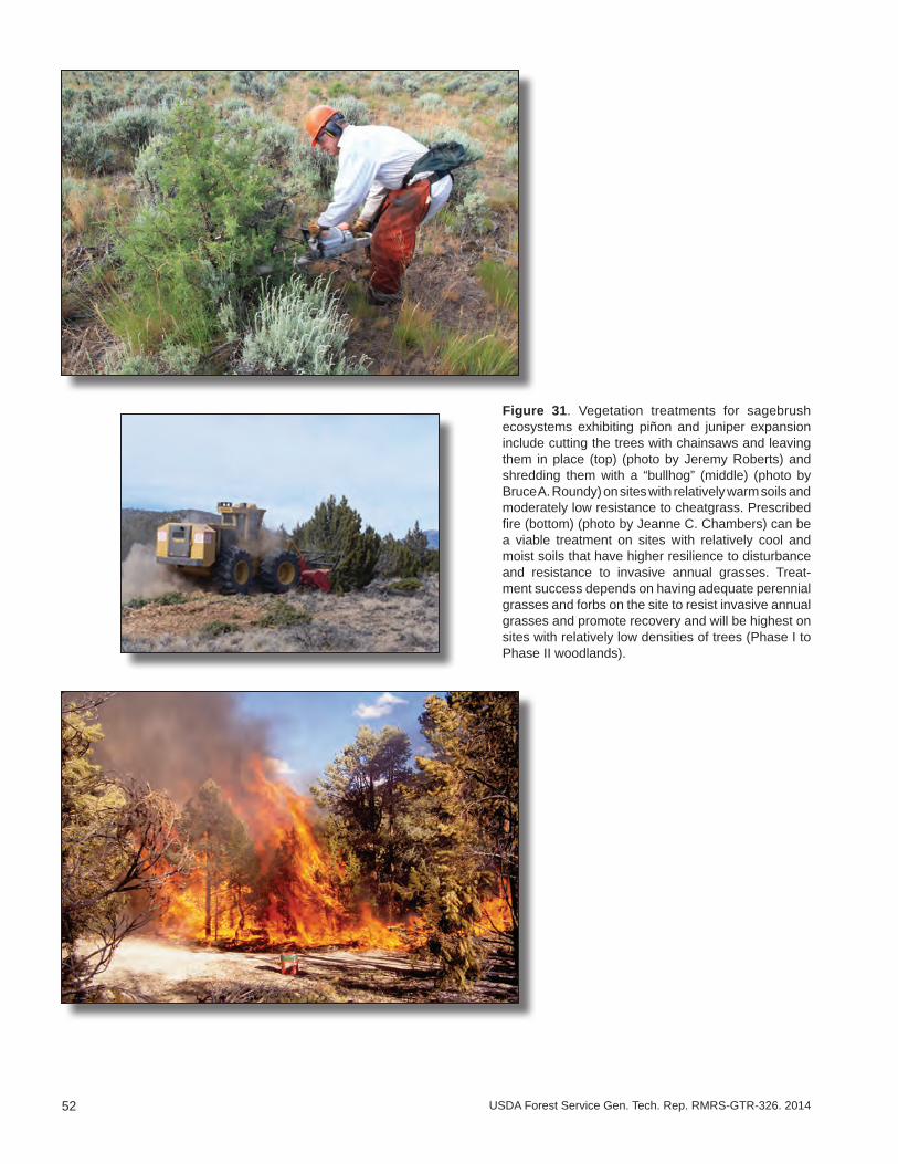
52 USDA Forest Service Gen. Tech. Rep. RMRS-GTR-326. 2014
Figure 31. Vegetation treatments for sagebrush ecosystems exhibiting piñon and juniper expansion include cutting the trees with chainsaws and leaving them in place (top) (photo by Jeremy Roberts) and shredding them with a “bullhog” (middle) (photo by Bruce A. Roundy) on sites with relatively warm soils and moderately low resistance to cheatgrass. Prescribed fire (bottom) (photo by Jeanne C. Chambers) can be a viable treatment on sites with relatively cool and moist soils that have higher resilience to disturbance and resistance to invasive annual grasses. Treat-ment success depends on having adequate perennial grasses and forbs on the site to resist invasive annual grasses and promote recovery and will be highest on sites with relatively low densities of trees (Phase I to Phase II woodlands).
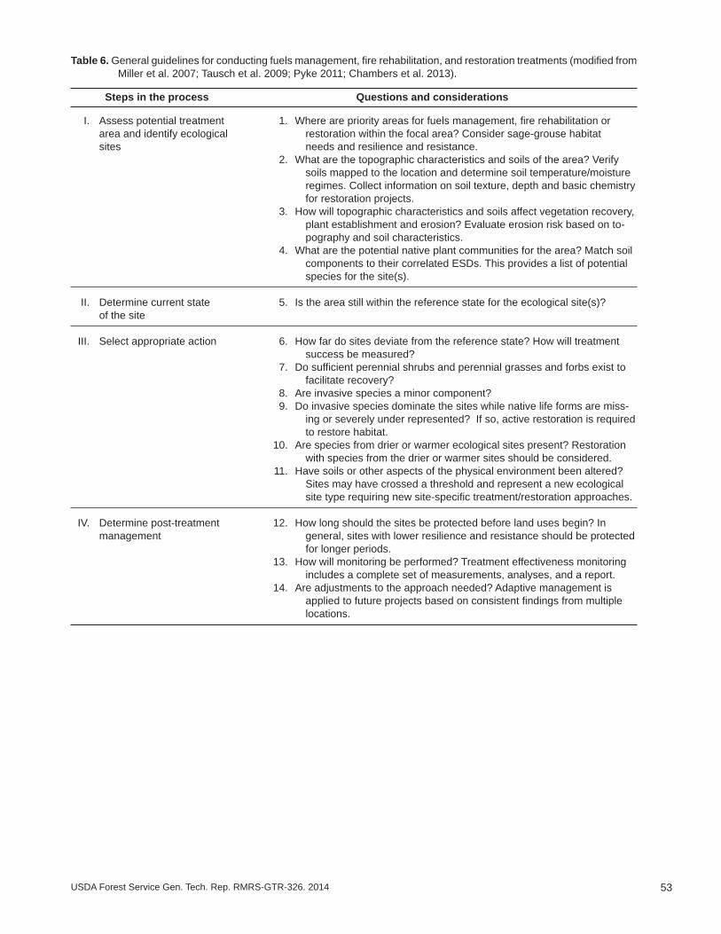
53USDA Forest Service Gen. Tech. Rep. RMRS-GTR-326. 2014
Table 6. General guidelines for conducting fuels management, fire rehabilitation, and restoration treatments (modified from Miller et al. 2007; Tausch et al. 2009; Pyke 2011; Chambers et al. 2013).
Steps in the process Questions and considerations
I. Assess potential treatment 1. Where are priority areas for fuels management, fire rehabilitation or area and identify ecological restoration within the focal area? Consider sage-grouse habitat sites needs and resilience and resistance. 2. What are the topographic characteristics and soils of the area? Verify
soils mapped to the location and determine soil temperature/moisture regimes. Collect information on soil texture, depth and basic chemistry for restoration projects.
3. How will topographic characteristics and soils affect vegetation recovery, plant establishment and erosion? Evaluate erosion risk based on to-pography and soil characteristics.
4. What are the potential native plant communities for the area? Match soil components to their correlated ESDs. This provides a list of potential species for the site(s).
II. Determine current state 5. Is the area still within the reference state for the ecological site(s)? of the site
III. Select appropriate action 6. How far do sites deviate from the reference state? How will treatment success be measured?
7. Do sufficient perennial shrubs and perennial grasses and forbs exist to facilitate recovery?
8. Are invasive species a minor component? 9. Do invasive species dominate the sites while native life forms are miss-
ing or severely under represented? If so, active restoration is required to restore habitat.
10. Are species from drier or warmer ecological sites present? Restoration with species from the drier or warmer sites should be considered.
11. Have soils or other aspects of the physical environment been altered? Sites may have crossed a threshold and represent a new ecological site type requiring new site-specific treatment/restoration approaches.
IV. Determine post-treatment 12. How long should the sites be protected before land uses begin? In management general, sites with lower resilience and resistance should be protected
for longer periods. 13. How will monitoring be performed? Treatment effectiveness monitoring
includes a complete set of measurements, analyses, and a report. 14. Are adjustments to the approach needed? Adaptive management is
applied to future projects based on consistent findings from multiple locations.

54 USDA Forest Service Gen. Tech. Rep. RMRS-GTR-326. 2014
Ecological site descriptions: ESDs and their associated STMs provide essential information for determining treatment feasibility and type of treatment. ESDs are part of a land classification system that describes the potential of a set of climate, topo-graphic, and soil characteristics and natural disturbances to support a dynamic set of plant communities (Bestelmeyer et al. 2009; Stringham et al. 2003). NRCS soil survey data (http://soils.usda.gov/survey/), including soil temperature/moisture regimes and other soil characteristics, are integral to ESD development. ESDs have been developed by the NRCS and their partners to assist land management agencies and private land owners with making resource decisions, and are widely available for the Sage-grouse MZs except where soil surveys have not been completed (for a detailed description of ESDs and access to available ESDs see: http://www.nrcs.usda.gov/wps/portal/nrcs/main/national/technical/ecoscience/desc/). ESDs assist managers to step-down generalized vegetation dynamics, including the concepts of resilience and resistance, to local scales. For example, variability in soil characteristics and the local environment (e.g., average annual precipitation as indicated by soil moisture regime) can strongly influence both plant community resilience to fire as well as the resistance of a plant community to invasive annual grasses after fire (table 1). Within a particular ESD, there is a similar level of resilience to disturbance and resistance to invasive annuals and this information can be used to determine the most appropriate management actions.
State and transition models: STMs are a central component of ecological site de-scriptions that are widely used by managers to illustrate changes in plant communities and associated soil properties, causes of change, and effects of management interventions (Stringham et al. 2003; Briske et al. 2005; USDA NRCS 2007) including in sagebrush ecosystems (Forbis et al. 2006; Barbour et al. 2007; Boyd and Svejcar 2009; Holmes and Miller 2010; Chambers et al. in press). These models use state (a relatively stable set of plant communities that are resilient to disturbance) and transition (the drivers of change among alternative states) to describe the range in composition and function of plant communities within ESDs (Stringham and others 2003; see Appendix 1 for defini-tions). The reference state is based on the natural range of conditions associated with natural disturbance regimes and often includes several plant communities (phases) that differ in dominant plant species relative to type and time since disturbance (Caudle et al. 2013). Alternative states describe new sets of communities that result from factors such as inappropriate livestock use, invasion by annual grasses, or changes in fire regimes. Changes or transitions among states often are characterized by thresholds that may persist over time without active intervention, potentially causing irreversible changes in community composition, structure, and function. Restoration pathways are used to identify the environmental conditions and management actions required for return to a previous state. Detailed STMs that follow current interagency guidelines (Caudle et al. 2013), are aligned with the ecological types (table 1), and are generally applicable to MZs III (Southern Great Basin), IV (Snake River Plains), V (Northern Great Basin), and VI (Columbia Basin) are provided in Appendix 5.
A generalized STM to illustrate the use of STMs is shown in figure 32 for the warm and dry Wyoming big sagebrush ecological type. This ecological type occurs at relatively low elevations in the western part of the range and has low to moderate resilience to disturbance and management treatments and low resistance to invasion (table 1). This type is abundant in the western portion of the range, but as the STM suggests, it is highly susceptible to conversion to invasive annual grass and repeated fire and is difficult to restore. Intact sagebrush areas remaining in the reference state within this ecological type are a high priority for conservation. Invaded states or locations with intact sagebrush that lack adequate native perennial understory are a high priority for restoration where they bridge large, contiguous areas of sagebrush. However, practical methods to accomplish this are largely experimental and/or costly and further development, including adaptive science and management, is needed.
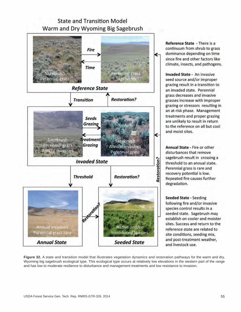
55USDA Forest Service Gen. Tech. Rep. RMRS-GTR-326. 2014
Figure 32. A state and transition model that illustrates vegetation dynamics and restoration pathways for the warm and dry, Wyoming big sagebrush ecological type. This ecological type occurs at relatively low elevations in the western part of the range and has low to moderate resilience to disturbance and management treatments and low resistance to invasion.
56 USDA Forest Service Gen. Tech. Rep. RMRS-GTR-326. 2014
Monitoring and adaptive management: Monitoring programs designed to track ecosystem changes in response to both stressors and management actions can be used to increase understanding of ecosystem resilience and resistance, realign management approaches and treatments, and implement adaptive management (Reever-Morghan et al. 2006; Herrick et al. 2012). Information is increasing on likely changes in sagebrush ecosystems with additional stress and climate warming, but a large degree of uncertainty still exits. Currently, the NRCS National Resource Inventory is being used on private lands and is being implemented on public lands managed by BLM to monitor trends in vegetation attributes and land health at the landscape scale under the AIM (Assess-ment Inventory and Monitoring) strategy. Strategic placement of monitoring sites and repeated measurements of ecosystem status and trends (e.g., land cover type, ground cover, vegetation cover and height of native and invasive species, phase of tree expan-sion, soil and site stability, oddities) can be used to decrease uncertainty and increase effectiveness of management decisions. Ideally, monitoring sites span environmental/productivity gradients and sagebrush ecological types that characterize sage-grouse habitat. Of particular importance are (1) ecotones between ecological types where changes in response to climate are expected to be largest (Loehle 2000; Stohlgren et al. 2000), (2) ecological types with climatic conditions and soils that are exhibiting invasion and repeated fires, and (3) ecological types with climatic conditions and soils that are exhibiting tree expansion and increased fire risk. Monitoring the response of sagebrush ecosystems to management treatments, including both pre- and post-treatment data, is a first order priority because it provides information on treatment effectiveness that can be used to adjust methodologies.
Monitoring activities are most beneficial when consistent approaches are used among and within agencies to collect, analyze, and report monitoring data. Currently, effective-ness monitoring databases that are used by multiple agencies do not exist. However, several databases have been developed for tracking fire-related and invasive-species management activities. The National Fire Plan Operations and Reporting System (NF-PORS) is an interdepartmental and interagency database that accounts for hazardous fuel reduction, burned area rehabilitation and community assistance activities. To our knowledge, NFPORS is not capable of storing and retrieving the type of effectiveness monitoring information that is needed for adaptive management. The FEAT FIREMON Integrated (FFI; https://www.frames.gov/partner-sites/ffi/ffi-home/) is a monitoring software tool designed to assist managers with collection, storage and analysis of eco-logical information. It was constructed through a complementary integration of the Fire Ecology Assessment Tool (FEAT) and FIREMON. This tool allows the user to select among multiple techniques for effectiveness monitoring. If effectiveness monitoring techniques were agreed on by the agencies, FFI does provide databases with standard structures that could be used in inter-agency effectiveness monitoring. Also, the National Invasive Species Information Management System (NISIMS) is designed to reduce redundant data entry regarding invasive species inventory, management and effective-ness monitoring with the goal of providing information that can be used to determine effective treatments for invasive species. However, NISIMS is currently available only within the BLM.
Common databases can be used by agency partners to record and share monitoring data. The Land Treatment Digital Library (LTDL [USGS 2010]) provides a method of archiving and collecting common information for land treatments and might be used as a framework for data storage and retrieval. Provided databases are rela-tional (maintain a common field for connecting them), creating single corporate databases is not necessary. However, barriers that hinder database access within and among agencies and governmental departments may need to be lowered while still maintaining adequate data security. The LTDL has demonstrated how

57USDA Forest Service Gen. Tech. Rep. RMRS-GTR-326. 2014
this can work by accessing a variety of databases to populate useful information relating to land treatments.
For effectiveness of treatments to be easily useable for adaptive management, the agencies involved will need to agree on monitoring methods and a common data storage and retrieval system. Once data can be retrieved, similar treatment projects can be evaluated to determine how well they achieve objectives for sage-grouse habitat, such as the criteria outlined in documents like the Habitat Assessment Framework (Stiver et al. 2006). Results of monitoring activities on treatment effectiveness are most useful when shared across jurisdictional bound-aries, and several mechanisms are currently in place to improve information sharing (e.g., the Great Basin Fire Science Delivery Project; www.gbfiresci.org).
References _______________________________________________________Abatzoglou, J. T.; Kolden, C. A. 2011. Climate change in western US deserts: potential for increased wildfire
and invasive annual grasses. Rangeland Ecology and Management 64:471-478.Aldridge, C. L.; Nielsen, S. E.; Beyer, H. L.; Boyce, M. S.; Connelly, J. W.; Knick, S. T.; Schroeder, M. A.
2008. Range-wide patterns of greater sage-grouse persistence. Diversity and Distributions 14:983–994.Alexander, E. B.; Mallory, J. I.; Colwell, W. L. 1993. Soil-elevation relationships on a volcanic plateau in
the southern Cascade Range, northern California, USA. Catena 20:113-128.Allen, C. R.; Gunderson, L.; Johnson, A. R. 2005. The use of discontinuities and functional groups to assess
relative resilience in complex systems. Ecosystems 8:958-966.Arredondo, J. T.; Jones, T.A.; Johnson, D. A. 1998. Seedling growth of Intermountain perennial and weedy
annual grasses. Journal of Range Management 51:584-589.Atamian, M.T.; Sedinger, J.S.; Heaton, J.S.; Blomberg, E.J. 2010. Landscape-level assessment of brood
rearing habitat for greater sage-grouse in Nevada. Journal of Wildlife Management 74: 1533–1543.Balch, J. K.; Bradley, B. A.; D’Antonio, C. M.; Gomez-Dans, J. 2013. Introduced annual grass increases
regional fire activity across the arid western USA (1980–2009). Global Change Biology 19:173-183.Barbour, R. J.; Hemstrom, M. A.; Hayes, J. L. 2007. The Interior Northwest Landscape Analysis System:
a step toward understanding integrated landscape analysis. Landscape and Urban Planning 80:333-344.Baruch-Mordo, S; Evans, J. S.; Severson, J. P.; Naugle; D.E.; Maestas, J. D.; Kiesecker, J. M.; Falkowski,
M. J.; Christian A. Hagen, C. A.; Reese, K. P. 2013. Saving sage-grouse from the trees: A proactive solu-tion to reducing a key threat to a candidate species. Biological Conservation 167:233-241.
Bates, J.D.; Sharp, R.N.; Davies, K.W. 2013. Sagebrush steppe recovery after fire varies by development phase of Juniperus occidentalis woodland. International Journal of Wildland Fire 23:117-130.
Beck, J. L.; Mitchell, D.L. 2000. Influences of livestock grazing on sage grouse habitat. Wildlife Society Bulletin 28:993-1002.
Beisner B. E.; Haydon, D. T.; Cuddington. K. 2003. Alternative stable states in ecology. Frontiers in Ecol-ogy 1:376-382
Bestelmeyer, B. T.; Tugel, A. J.; Peacock, G. L. J.; Robinett, D. G.; Shaver, P. L.; Brown, J. R.; Herrick, J. E.; Sanchez, H.; Havstad, K.M. 2009. State-and transition models for heterogeneous landscapes: a strategy for development and application. Rangeland Ecology and Management 62:1-15
Blank R. S.; Morgan, T. 2012. Suppression of Bromus tectorum L. by established perennial grasses: potential mechanisms – Part One. Applied Environmental Soil Science 2012: Article ID 632172. 9 p. doi:10.1155/2012/632172.
Blomberg, E. J.; Sedinger, J. S.; Atamian, M. T.; Nonne, D. V. 2012. Characteristics of climate and land-scape disturbance influence the dynamics of greater sage-grouse populations. Ecosphere 3(6):55. Online: http://dx.doi.org/10.1890/ES11-00304.1.
Booth, M. S.; Caldwell, M. M.; Stark, J. M. 2003. Overlapping resource use in three Great Basin species: implications for community invisibility and vegetation dynamics. Journal of Ecology 91:36-48.
Boyd, C. S.; Svejcar, T. J. 2009. Managing complex problems in rangeland ecosystems. Rangeland Ecol-ogy and Management 62:491-499.
Bradford, J. B.; Lauenroth, W. K. 2006. Controls over invasion of Bromus tectorum: the importance of climate, soil, disturbance and seed availability. Journal of Vegetation Science 17:693-704.
Bradley B.A. 2009. Regional analysis of the impacts of climate change on cheatgrass invasion shows po-tential risk and opportunity. Global Change Biology 15:196-208 doi: 10.1111/j.1365-2486.2008.01709.x.
Bradley, B. A.; Mustard, J. F. 2005. Identifying land cover variability distinct from land cover change: cheatgrass in the Great Basin. Remote Sensing of Environment 94:204-213.
58 USDA Forest Service Gen. Tech. Rep. RMRS-GTR-326. 2014
Briske, D. D.; Fuhlendorf, S. D.; Smeins, F. E. 2005. State-and-transition models, thresholds, rangeland health: a synthesis of ecological concepts and perspectives. Rangeland Ecology and Management 58:1-10.
Brooks M. L.; Chambers, J. C. 2011. Resistance to invasion and resilience to fire in desert shrublands of North America. Rangeland Ecology and Management 64:431–438.
Brooks, M. L.; D’Antonio, C. M.; Richardson, D. M.; Grace, J. B.; Keeley, J. E.; DiTomaso, J. M.; Hobbs, R. J.; Pellant, M.; Pyke, D. 2004. Effects of invasive alien plants on fire regimes. BioScience 54:677-688.
Brown, J. K.; Smith, J. K. 2000. Wildland fire in ecosystems: Effects of fire on flora. Gen.Tech. Rep. RMRS- GTR-42-vol. 2. Ogden, UT: U.S. Department of Agriculture, Forest Service, Rocky Mountain Research Station. 257 p.
Butler, B. B.; Bailey, A. 2013. Disturbance history (Historical Wildland Fires). Updated 8/9/2013. Wildland Fire Decision Support System. Online: https://wfdss.usgs.gov/wfdss/WFDSS_Data_Downloads.shtml. [Accessed 5 March 2014].
Casazza, M. L.; Coates, P. S.; Overton; C. T. 2011. Linking habitat selection and brood success in Greater Sage-Grouse. In: Sandercock, B.K.; Martin, K.; Segelbacher, G., eds. Ecology, conservation, and man-agement of grouse. Studies in Avian Biology 39., Berkeley, CA: University of California Press: 151-167.
Caudle, D.; DiBenedetto, J.; Karl, M.; Sanchez, H.; Talbot, C. 2013. Interagency ecological site handbook for rangelands. Online: http://jornada.nmsu.edu/sites/jornada.nmsu.edu/files/InteragencyEcolSiteHand-book.pdf [Accessed 17 June 2014].
Chambers, J. C.; Bradley, B.A.; Brown, C.A.; D’Antonio, C.; Germino, M. J.; Hardegree, S. P; Grace, J. B.; Miller, R. F.; Pyke, D. A. 2014. Resilience to stress and disturbance, and resistance to Bromus tectorum L. invasion in the cold desert shrublands of western North America. Ecosystems 17: 360-375
Chambers, J.C.; Miller, R. F.; Board, D. I.; Grace, J. B.; Pyke, D. A.; Roundy, B. A.; Schupp, E. W.; Tausch, R. J. [In press].Resilience and resistance of sagebrush ecosystems: implications for state and transition models and management treatments. Rangeland Ecology and Management.
Chambers, J. C.; Pendleton, B. K.; Sada, D. W.; Ostoja, S. M.; Brooks, M. L.. 2013. Maintaining and restoring sustainable ecosystems. In: Chambers, J. C.; Brooks, M. L.; Pendleton, B. K.; Raish, C. B., eds. The Southern Nevada Agency Partnership Science and Research Synthesis: Science to support land management in southern Nevada. Gen. Tech. Rep. RMRS-GTR-303. Fort Collins, CO: U.S. Department of Agriculture, Forest Service, Rocky Mountain Research Station:125-154.
Chambers, J. C.; Roundy, B. A.; Blank, R. R.; Meyer, S. E.; Whittaker, A. 2007. What makes Great Basin sagebrush ecosystems invasible by Bromus tectorum? Ecological Monographs 77:117-145.
Condon L.; Weisberg, P. L.; Chambers, J. C. 2011. Abiotic and biotic influences on Bromus tectorum inva-sion and Artemisia tridentata recovery after fire. International Journal of Wildland Fire 20:1-8.
Connelly, J. W.; Hagen, C. A.; Schroeder, M. A. 2011a. Characteristics and dynamics of greater sage-grouse populations. In: Knick, S.T.; Connelly J.W., eds. Greater Sage-Grouse: ecology and conservation of a landscape species and its habitats. Studies in Avian Biology 38. University of California Press, Berkeley, CA: 53-68.
Connelly, J. W.; Rinkes, E. T.; Braun, C. E. 2011b. Characteristics of greater sage-grouse habitats: a land-scape species at micro and macro scales. In: Knick, S.T.; Connelly, J.W., eds. Greater Sage-Grouse: ecology and conservation of a landscape species and its habitats. Studies in Avian Biology 38. University of California Press, Berkeley, CA: 69-84.
D’Antonio C. M.; Thomsen M. 2004. Ecological resistance in theory and practice. Weed Technology 18:1572-1577.
D’Antonio C. M.; Vitousek, P. M. 1992. Biological invasions by exotic grasses, the grass/fire cycle, and global change. Annual Review of Ecology and Systematics 23:63-87.
Dahlgren R. A; Boettinger, J. L.; Huntington, G. L.; Amundson, R. G. 1997. Soil development along an elevational transect in the western Sierra Nevada. Geoderma 78:207-236.
Davies, K. W.; Boyd, C. S.; Beck, J. L.; Bates, J. D.; Svejcar, T. J.; Gregg, M. A. 2011. Saving the sagebrush sea: An ecosystem conservation plan for big sagebrush plant communities. Biological Conservation 144: 2573–2584.
Davies, K. W.; Svejcar, T. J.; Bates, J. D. 2009. Interaction of historical and nonhistorical disturbances maintains native plant communities. Ecological Applications 19(6): 1536–1545.
Davies G. M.; Bakker, J. D.; Dettweiler-Robinson, E.; Dunwiddie, P. W.; Hall, S.A.; Downs, J.; Evans, J. 2012. Trajectories of change in sagebrush-steppe vegetation communities in relation to multiple wildfires. Ecological Applications 22:1562-1577.
Doherty, K. E.; Naugle, D. E.; Walker, B. L.; Graham, J. M. 2008. Greater sage-grouse winter habitat selection and energy development. Journal of Wildlife Management 72:187-195.
Doherty, K. E.; Naugle, D. E.; Walker, B. L. 2010a. Greater Sage-Grouse Nesting Habitat: The Importance of Managing at Multiple Scales. Journal of Wildlife Management 74:1544-1553.
59USDA Forest Service Gen. Tech. Rep. RMRS-GTR-326. 2014
Doherty, K. E.; Tack, J. D.; Evans, J. S.; Naugle, D. E 2010b. Mapping breeding densities of greater sage-grouse: A tool for range-wide conservation planning. BLM completion report: Agreement # L10PG00911. Online: http://www.blm.gov/pgdata/etc/medialib/blm/wo/Planning_and_Renewable_Re-sources/fish__wildlife_and/sage-grouse.Par.6386.File.dat/MOU%20on%20Greater%20Sage-Grouse.pdf [Accessed 17 June 2014].
Eckert, R. E.; Peterson, F. F.; Meurisse, M. S.; Stephens, J. L. 1986. Effects of soil-surface morphology on emergence and survival of seedlings in big sagebrush communities. Journal Range Management 39:414-420
Finney, M. A.; McHugh, C. W.; Grenfell, I. 2010. Continental-scale simulation of burn probabilities, flame lengths, and fire size distributions for the United States. In: Viegas, D. X., ed. Fourth international conference on forest fire research; Coimbra, Portugal; 13-18 November 2010. Associacao para o De-senvolvimento da Aerodinamica Industrial. 12 p.
Folke C.; Carpenter, S.; Walker, B.; Scheffer, M.; Elmqvist, T.; Gunderson, L.; Holling, C. S. 2004. Regime shifts, resilience, and biodiversity in ecosystem management. Annual Review of Ecology, Evolution, and Systematics 35:557-581.
Forbis, T. A.; Provencher, L.; Frid, L.; Medlyn, G. 2006. Great Basin land management planning using ecological modeling. Environmental Management 38:62-83.
Frost, C. C. 1998. Presettlement fire frequency regimes of the United States. A first approximation. In: Pruden, T. T.; Brennan, L. A., eds. Fire in ecosystem management: shifting the paradigm from suppression to prescription. Proceedings 20th Tall Timbers Fire Ecology Conference. Tallahassee, FL: Tall Timbers Research Station: 70-82.
Herrick, J. E.; Duniway, M. C.; Pyke, D. A.; Bestelmeyer, B. T.; Wills, S. A.; Brown, J. R.; Karl, J. W.; Havstad, K. M. 2012. A holistic strategy for adaptive land management. Journal of Soil and Water Conservation 67: 105A-113A.
Holling C. S. 1973. Resilience and stability in ecological systems. Annual Review of Ecology and Sys-tematics 4:1-23.
Holmes, A. A.; Miller, R. F. 2010. State-and-transition models for assessing grasshopper sparrow habitat use. Journal of Wildlife Management 74:1834–1840. doi: 10.2193/2009-417.
Jackson S. T. 2006. Vegetation, environment, and time: The origination and termination of ecosystems. Journal of Vegetation Science 17:549-557.
James, J. J.; Drenovsky, R. A.; Monaco, T. A.; Rinella, M. J. 2011. Managing soil nitrogen to restore annual grass-infested plant communities: Effective strategy or incomplete framework? Ecological Applications 21:490-502
Johnson D. D.; Miller, R. F. 2006. Structure and development of expanding western juniper woodlands as influenced by two topographic variables. Forest Ecology and Management 229:7-15.
Johnson, D. H.; Holloran, M. J.; Connelly, J. W.; Hanser, S. E.; Amundson, C. L.; Knick, S. T. 2011. In-fluence of environmental and anthropogenic features on greater sage-grouse populations. In: Knick S. T.; Connelly, J. W., eds. Greater sage-grouse – ecology and conservation of a landscape species and its habitats. Studies in Avian Biology 38. Berkeley, CA: University of California Press: 407-450.
Kaltenecker, .J. H.; Wicklow-Howard, M., Pellant, M. 1999. Biological soil crusts: natural barriers to Bromus tectorum L. establishment in the northern Great Basin, USA. In: Eldridge D.; Freudenberger D., eds. Proceedings of the VI International Rangeland Congress; Aitkenvale, Queensland, Australia: 109-111.
Keeley, J. 2009. Fire intensity, fire severity and burn severity: A brief review and suggested usage. Inter-national Journal of Wildland Fire 18:116–126.
Kirol, C. P.; Beck, J. L.; Dinkins, J. B.; Conover, M. R. 2012. Microhabitat selection for nesting and brood rearing by the greater sage-grouse in xeric big sagebrush. The Condor 114(1):75-89.
Knapp, P. A. 1996. Cheatgass (Bromus tectorum) dominance in the Great Basin Desert. Global Environ-mental Change 6:37-52.
Knick, S. T.; Hanser, S. E.; Preston, K. L. 2013. Modeling ecological minimum requirements for distribu-tion of greater sage-grouse leks: Implications for population connectivity across their western range, U.S.A. Ecology and Evolution 3(6):1539–1551.
Knutson, K. C.; Pyke, D. A.; Wirth, T. A.; Arkle, R. S.; Pilliod, D. S.; Brooks, M. L.; Chambers, J. C.; Grace, J. B. 2014. Long-term effects of reseeding after wildfire on vegetation composition in the Great Basin shrub steppe. Journal of Applied Ecology. doi: 10.1111/1365-2664.12309.
Littell, J. S.; McKenzie, D.; Peterson, D. L.; Westerling, A. L. 2009. Climate and wildfire area burned in the western U.S. ecoprovinces, 1916-2003. Ecological Applications 19:1003-1021.
Lockyer, Z. B. 2012. Greater sage-grouse (Centrocercus urophasianus) nest predators, nest survival, and nesting habitat at multiple spatial scales. M.S. thesis. Department of Biological Sciences, Idaho State University, Pocatello, ID.
Loehle, C. 2000. Forest ecotone response to climate change: Sensitivity to temperature response functional forms. Canadian Journal of Forest Research 30: 1362-1645.
Mack, R. N.; Pyke, D. A. 1983. Demography of Bromus tectorum: Variation in time and space. Journal of Ecology 71: 6993.

60 USDA Forest Service Gen. Tech. Rep. RMRS-GTR-326. 2014
Manier, D. J.; Wood, D. J. A.; Bowen, Z. H.; Donovan, R. M.; Holloran, M. J.; Juliusson, L. M.; Mayne, K. S.; Oyler-McCance, S. J.; Quamen, F. R.; Saher, D. J.; Titolo, A. J. 2013. Summary of science, activities, programs and policies that influence the rangewide conservation of greater sage-grouse (Centrocercus urophasianus). Open-File Report 2013-1098. Washington, DC: U.S. Department of the Interior, U.S. Geological Survey. 297 p.
Meinke, C. W.; Knick, S. T.; Pyke, D. A. 2009. A spatial model to prioritize sagebrush landscapes in the Intermountain West (U.S.A.) for restoration. Restoration Ecology 17:652-659.
Mensing, S.; Livingston, S.; Barker, P. 2006. Long-term fire history in Great Basin sagebrush reconstructed from macroscopic charcoal in spring sediments, Newark Valley, Nevada. Western North American Naturalist 66:64-77.
Merrill K. R.; Meyer, S. E.; Coleman, C. E. 2012, Population genetic analysis of Bromus tectorum (Poa-ceae) indicates recent range expansion may be facilitated by specialist geonotypes. American Journal of Botany 99:529-537.
Meyer S. E.; Garvin, S. C.; Beckstead, J. 2001. Factors mediating cheatgrass invasion of intact salt desert shrubland. In: McArthur, D. E.; Fairbanks, D. J., comps. Shrubland ecosystem genetics and biodiversity: proceedings. Proc. RMRS-P-21. Ogden UT: U.S. Department of Agriculture, Forest Service, Rocky Mountain Research Station: 224-232.
Miller, R. F; Bates, J. D.; Svejcar, T. J.; Pierson, F. B.; Eddleman, L. E. 2005. Biology, ecology, and management of western juniper. Tech. Bull. 152. Corvallis, OR: Oregon State University, Agricultural Experiment Station.
Miller, R.F.; Bates, J.D.; Svejcar, T.J.; Pierson, F.B.; Eddleman, L.E. 2007. Western juniper field guide: asking the right questions to select appropriate management actions. Geological Survey Circular 1321. Reston, VA: U.S. Department of the Interior, Geological Survey,
Miller R. F; Chambers, J. C.; Pellant, M. 2014a. A field guide to selecting the most appropriate treatments in sagebrush and pinyon-juniper ecosystems in the Great Basin: Evaluating resilience to disturbance and resistance to invasive annual grasses and predicting vegetation response. Gen. Tech. Rep. RMRS-GTR-322. Fort Collins, CO: U.S. Department of Agriculture, Forest Service, Rocky Mountain Research Station.
Miller R. F.; Chambers, J. C.; Pellant, M.[In preparation]. A field guide for rapid assessment of post-wildfire recovery potential in sagebrush and pinon-juniper ecosystems in the Great Basin: Evaluating resilience to disturbance and resistance to invasive annual grasses and predicting vegetation response. Gen. Tech. Rep. RMRS-GTR-###. . Fort Collins, CO: U.S. Department of Agriculture, Forest Service, Rocky Mountain Research Station.
Miller, R. F.; Chambers, J. C.; Pyke, D. A.; Pierson, F. B.; Williams, C. J. 2013. A review of fire effects on vegetation and soils in the Great Basin Region: Response and ecological site characteristics. Gen. Tech. Rep. RMRS-GTR-308. Fort Collins, CO: Department of Agriculture, Forest Service, Rocky Mountain Research Station. 136 p.
Miller, R. F.; Eddleman, L L. 2001. Spatial and temporal changes of sage grouse habitat in the sagebrush biome. Bulletin 151. Corvallis, OR: Oregon State University, Agricultural Experiment Station.
Miller, R. F.; Heyerdahl, E. K. 2008. Fine-scale variation of historical fire regimes in sagebrush-steppe and juniper woodlands: an example from California, USA. International Journal of Wildland Fire 17: 245-254.
Miller R. F.; Knick, S. T.; Pyke, D. A.; Meinke, C. W.; Hanser, S. E.; Wisdom, M. J.; Hild, A. L. 2011. Characteristics of sagebrush habitats and limitations to long-term conservation. In: Knick S. T.; Con-nelly, J. W. eds. Greater sage-grouse – ecology and conservation of a landscape species and its habitats. Studies in Avian Biology 38. Berkeley, CA: University of California Press: 145-185.
Miller, R.F.; Svejcar, T.J.; Rose, J.A. 2000. Impacts of western juniper on plant community composition and structure. Journal of Range Management 53:574-585.
Miller, R. F.; Tausch, R. J.; McArthur, E. D.; Johnson, D. D.; Sanderson, S. C. 2008. Age structure and expansion of piñon-juniper woodlands: A regional perspective in the Intermountain West. Res. Pap. RMRS-RP-69. Fort Collins, CO: U.S. Department of Agriculture, Forest Service, Rocky Mountain Research Station. 15 p.
Monsen, Stephen B.; Stevens, Richard; Shaw, Nancy L., comps. 2004. Restoring western ranges and wildlands. Gen. Tech. Rep. RMRS-GTR-136-vol-1, 2, and 3. Fort Collins, CO: U.S. Department of Agriculture, Forest Service, Rocky Mountain Research Station. 884 p. + appendices and index.
Murphy, T.; Naugle, D. E.; Eardley, R.; Maestas, J. D.; Griffiths, T.; Pellant, M.; Stiver, S. J. 2013. Trial by fire: Improving our ability to reduce wildfire impacts to sage-grouse and sagebrush ecosystems through accelerated partner collaboration. Rangelands 32:2–10.
Oregon Department of Forestry. 2013. West wide wildfire risk assessment final report. Salem, OR: Oregon Department of Forestry. 105 p. Online: http://www.odf.state.or.us/gis/data/Fire/West_Wide_Assessment/WWA_FinalReport.pdf [Accessed 17 June 2014].
Peterson, E. B. 2006. A map of invasive annual grasses in Nevada derived from multitemporal Landsat 5 TM imagery. Carson City, NV: State of Nevada, Department of Conservation and Natural Resources, Nevada Natural Heritage Program.
61USDA Forest Service Gen. Tech. Rep. RMRS-GTR-326. 2014
Peterson, E. B. 2007. A map of annual grasses in the Owyhee Uplands, Spring 2006, derived from multi-temporal Landsat 5 TM imagery. Carson City, NV: State of Nevada, Department of Conservation and Natural Resources, Nevada Natural Heritage Program.
Pyke, D. A. 2011. Restoring and rehabilitating sagebrush habitats. In: Knick, S. T.; Connelly, J. W., eds. Greater sage-grouse: Ecology and conservation of a landscape species and its habitats. Studies in Avian Biology 38. Berkeley, CA: University of California Press: 531-548.
Pyke, D. A., M. Pellant, S. T. Knick, J. L. Beck, P. S. Doescher, E. W. Schupp, J. C. Chambers, R. F. Miller, B. A. Roundy, M. Brunson, and J. D. McIver. [In preparation]. Field guide for restoration of sagebrush-steppe ecosystems with special emphasis on Greater Sage-Grouse habitat- considerations to increase the likelihood of success at local to regional levels. U.S. Geological Circular, Reston, VA.
Ramakrishnan A. P.; Meyer, S. E.; Fairbanks, D. J.; Coleman, C. E. 2006. Ecological significance of mic-rosatellite variation in western North American populations of Bromus tectorum. Plant Species Biology 21:61-73.
Redford, K. H.; Amoto, G.; Baillie, J.; Beldomenico, P.; Bennett, E. L.; Clum, N.; Cook, R.; Fonseca, G.; Hedges, S.; Launay, F.; Lieberman, S.; Mace, G. M.; Murayama, A.; Putnam, A.; Robinson, J. G.; Rosenbaum, H.; Sanderson, E. W.; Stuart, S. N.; Thomas, P.; Thorbjarnarson, J. 2011. What does it mean to successfully conserve a (vertebrate) species? Bioscience 61:39-48.
Reever-Morghan, K. J.; Sheley, R. L.; Svejcar, T. J. 2006. Successful adaptive management: The integration of research and management. Rangeland Ecology and Management 59:216-219.
Reisner, M. D.; Grace, J. B.; Pyke, D. A.; Doescher, P. S. 2013. Conditions favouring Bromus tectorum dominance of endangered sagebrush steppe ecosystems. Journal of Applied Ecology 50:1039-1049.
Roundy, B. A.; Young, K.; Cline, N.; Hulet, A.; Miller, R. F.; Tausch, R. J.; Chambers, J. C.; Rau, B. [In press]. Piñon-juniper reduction effects on soil temperature and water availability of the resource growth pool. Rangeland Ecology and Management.
Rowland, M. M.; Leu, M.; Finn, S. P.; Hanser, S.; Suring, L. H.; Boys, J. M.; Meinke, C. W.; Knick, S. T.; Wisdom, M. J. 2006. Assessment of threats to sagebrush habitats and associated species of concern in the Wyoming Basins. Version 1, March 2005. Unpublished report on file at: USGS Biological Resources Discipline, Snake River Field Station, Boise, ID.
Sala, O. E.; Lauenroth,W. K.; Gollucio, R. A. 1997. Plant functional types in temperate semi-arid regions. In: Smith, T. M.; Shugart, H. H.; Woodward, F. I., eds. Plant functional types. Cambridge, UK: Cam-bridge University Press: 217-233.
Seastedt T. R.; Hobbs, R. J.; Suding, K. N. 2008. Management of novel ecosystems: Are novel approaches required? Frontiers in Ecology and Environment 6:547-553.
Smith, S. D.; Nowak, R. S.; 1990. Ecophysiology of plants in the Intermountain lowlands. In: Osmond, C. B.; Pitelka, L. F.; Hidy, G. M., eds. Plant Biology of the Basin and Range. Springer-Verlag: 179-242.
Soil Survey Staff. 2014a. Soil Survey Geographic (SSURGO) Database. United States Department of Agriculture, Natural Resources Conservation Service. Online: http://sdmdataaccess.nrcs.usda.gov/. [Accessed 3 March 2014].
Soil Survey Staff. 2014b. U.S. General Soil Map (STATSGO2) Database. United States Department of Agriculture, Natural Resources Conservation Service. Online: http://sdmdataaccess.nrcs.usda.gov/. [Accessed 3 March 2014].
Stiver, S. J.; Apa, A. D.; Bohne, J. R.; Bunnell, S. D.; Deibert, P. A.; Gardner, S. C.; Hilliard, M. A.; McCarthy, C. W.; Schroeder, M. A. 2006. Greater Sage-grouse Comprehensive Conservation Strategy. Unpublished report on file at: Western Association of Fish and Wildlife Agencies, Cheyenne, WY.
Stohlgren, T. J.; Owen, A. J.; Lee, M. 2000. Monitoring shifts in plant diversity in response to climate change: a method for landscapes. Biodiversity and Conservation 9:165-186.
Stringham, T. K.; Krueger, W. C.; Shaver, P. L. 2003. State and transition modeling: An ecological process approach. Journal of Range Management 56:106–113.
Tausch, R. J.; Miller, R. R.; Roundy, B. A.; Chambers, J. C. 2009. Piñon and juniper field guide: asking the right questions to select appropriate management actions. Circular 1335. Reston, VA: U.S. Depart-ment of the Interior, U.S. Geological Survey. 94 p. Online: http://pubs.usgs.gov/circ/1335/. [Accessed 17 June 2014].
USDA Natural Resources Conservation Service [USDA-NRCS]. 2007. National soil survey handbook, Title 430-VI. Online: http://www.nrcs.usda.gov/wps/portal/nrcs/detail/soils/survey/?cid=nrcs142p2_054242 /. [Accessed 17 June 2014].
U.S. Fish and Wildlife Service [USFWS]. 2010. Endangered and threatened wildlife and plants; 12-month findings for petitions to list the greater sage-grouse (Centrocercus urophasianus) as threatened or endangered; proposed rule. Fed. Register 75, 13910–14014. Online: http://www.fws.gov/policy/li-brary/2010/2010-5132.pdf.
U.S. Fish and Wildlife Service [USFWS]. 2013. Greater sage-grouse (Centrocercus urophasianus) conser-vation objectives: Final Report. Denver, CO: U.S. Fish and Wildlife Service. 91 p.
62 USDA Forest Service Gen. Tech. Rep. RMRS-GTR-326. 2014
U.S. Geological Survey (USGS). 2010. Land Treatment Digital Database. Online: http://ltdl.wr.usgs.gov/. [Accessed 17 June 2014].
U.S. Geological Survey (USGS). 2013: LANDFIRE 1.2.0 Existing Vegetation Type layer. Updated 3/13/2013. Washington, DC: U.S. Department of the Interior, Geological Survey. Online: http://landfire.cr.usgs.gov/viewer/. [Accessed 17 June 2014].
U.S. Geological Survey (USGS) National Gap Analysis Program. 2004. Provisional digital land cover map for the southwestern United States. Version 1.0. Logan: Utah State University, College of Natural Resources, RS/GIS Laboratory. Online: http://earth.gis.usu.edu/swgap/landcover.html. [Accessed 9 June 2014].
Walters, S. P.; Schneider, N. J.; Guthrie, J. D. 2011. Geospatial Multi-Agency Coordination (GeoMAC) wildland fire perimeters, 2008. Data Series 612: Washington, DC: U.S. Department of the Interior, U.S. Geological Survey. 6 p.
West, N.E. 1983a. Intermountain salt-desert shrubland. In: West, N.E., ed. Temperate deserts and semi-deserts. Amsterdam, The Netherlands: Elsevier Publishing Company: 375-378.
West, N. E. 1983b. Great Basin-Colorado Plateau sagebrush semi-desert. In: West, N. E., ed. Temperate deserts and semi-deserts. Amsterdam, The Netherlands: Elsevier Publishing Company: 331-350
West, N. E.; Young, J. A. 2000. Intermountain valleys and lower mountain slopes. In: Barbour, M. B.; Billings, W. D., eds. North American terrestrial vegetation. Cambridge, UK: Cambridge University Press: 256-284
Westerling A. L.; Hidalgo, H. G.; Cayan, D. R.; Swetnam, T. W. 2006. Warming and early spring increase U.S. forest wildfire activity. Science 313: 940-943.
Wisdom, M. J.; Chambers, J. C. 2009. A landscape approach for ecologically-based management of Great Basin shrublands. Restoration Ecology 17:740-749.
Wisdom, M. J.; Meinke, C. W.; Knick, S. T.; Schroeder, M. A. 2011. Factors associated with extirpation of sage-grouse. In: Knick, S. T.; Connelly, J. W., eds. Greater sage-Grouse: Ecology and conservation of a landscape species and its habitats. Studies in Avian Biology 38. Berkeley, CA: University of California Press: 451-474.
Wisdom, M. J.; Rowland, M. M.; Suring, L. H. eds. 2005. Habitat threats in the sagebrush ecosystem: Methods of regional assessment and applications in the Great Basin. Lawrence, KS: Alliance Commu-nications Group, Allen Press. 301 p.
63USDA Forest Service Gen. Tech. Rep. RMRS-GTR-326. 2014
Appendix 1. Definitions of Terms Used in This Document ________________
At-Risk Community Phase — A community phase that can be designated within the reference state and also in alternative states. This community phase is the most vulnerable to transition to an alternative state (Caudle et al. 2013).
Community Phase — A unique assemblage of plants and associated soil properties that can occur within a state (Caudle et al. 2013).
Ecological Site (ES) — An Ecological Site (ES) is a conceptual division of the landscape that is defined as a distinctive kind of land based on recurring soil, landform, geo-logical, and climate characteristics that differs from other kinds of land in its ability to produce distinctive kinds and amounts of vegetation and in its ability to respond similarly to management actions and natural disturbances (Caudle et al. 2013).
Ecological Site Descriptions (ESD) — The documentation of the characteristics of an ecological site. The documentation includes the data used to define the distinctive properties and characteristics of the ecological site; the biotic and abiotic character-istics that differentiate the site (i.e., climate, topography, soil characteristics, plant communities); and the ecological dynamics of the site that describes how changes in disturbance processes and management can affect the site. An ESD also provides interpretations about the land uses and ecosystem services that a particular ecologi-cal site can support and management alternatives for achieving land management (Caudle et al. 2013).
Ecological Type — A category of land with a distinctive (i.e., mappable) combination of landscape elements. The elements making up an ecological type are climate, geol-ogy, geomorphology, soils, and potential natural vegetation. Ecological types differ from each other in their ability to produce vegetation and respond to management and natural disturbances (Caudle et al. 2013).
Historical Range of Variability — Range of variability in disturbances, stressors, and ecosystem attributes that allows for maintenance of ecosystem resilience and resistance and that can be used to provide management targets (modified from Jackson 2006).
Resilience — Ability of a species and/or its habitat to recover from stresses and dis-turbances. Resilient ecosystems regain their fundamental structure, processes, and functioning when altered by stresses like increased CO2 , nitrogen deposition, and drought and to disturbances like land development and fire (Allen et al. 2005; Hol-ling 1973).
Resistance — Capacity of an ecosystem to retain its fundamental structure, processes and functioning (or remain largely unchanged) despite stresses, disturbances, or invasive species (Folke et al. 2004).
Resistance to Invasion — Abiotic and biotic attributes and ecological processes of an ecosystem that limit the population growth of an invading species (D’Antonio and Thomsen 2004).
Restoration Pathways — Restoration pathways describe the environmental conditions and practices that are required for a state to recover that has undergone a transition (Caudle et al. 2013).
State — A state is a suite of community phases and their inherent soil properties that interact with the abiotic and biotic environment to produce persistent functional and structural attributes associated with a characteristic range of variability (adapted from Briske et al. 2008).
64 USDA Forest Service Gen. Tech. Rep. RMRS-GTR-326. 2014
State-and-Transition Model — A method to organize and communicate complex information about the relationships between vegetation, soil, animals, hydrology, disturbances (fire, lack of fire, grazing and browsing, drought, unusually wet peri-ods, insects and disease), and management actions on an ecological site (Caudle et al. 2013).
Thresholds — Conditions sufficient to modify ecosystem structure and function beyond the limits of ecological resilience, resulting in the formation of alternative states (Briske et al. 2008).
Transition — Transitions describe the biotic or abiotic variables or events, acting independently or in combination, that contributes directly to loss of state resilience and result in shifts between states. Transitions are often triggered by disturbances, including natural events (climatic events or fire) and/or management actions (graz-ing, burning, fire suppression). They can occur quickly as in the case of catastrophic events like fire or flood, or over a long period of time as in the case of a gradual shift in climate patterns or repeated stresses like frequent fires (Caudle et al. 2013).
65USDA Forest Service Gen. Tech. Rep. RMRS-GTR-326. 2014
Appendix 2. An Explanation of the Use of Landscape Measures to Describe Sagebrush Habitat _________________________________________________
Understanding landscape concepts of plant cover relative to typical management unit concepts of plant cover is important for prioritizing lands for management of sage-grouse. Ground cover measurements of sagebrush made at a management unit (for example, line-intercept measurements) should not be confused for landscape cover and may not relate well to landscape cover since the areas of examination differ vastly (square meters for management units and square kilometers for landscapes).
A landscape is defined rather arbitrarily as a large area in total spatial extent, somewhere in size between sites (acres or square miles) and regions (100,000s of square miles). The basic unit of a landscape is a patch, which is defined as a bounded area characterized by a similar set of conditions. A habitat patch, for example, may be the polygonal area on a map representing a single land cover type. Landscapes are composed of a mosaic of patches. The arrangement of these patches (the landscape configuration or pattern) has a large influence on the way a landscape functions and for landscape species, such as sage-grouse, sagebrush habitat patches are extremely important for predicting if this bird will be present within the area (Connelly et al. 2011).
Remotely sensed data of land cover is typically used to represent landscapes. These data may combine several sources of data and may include ancillary data, such as el-evation, to improve the interpretation of data. These data are organized into pixels that contain a size or grain of land area. For example, LandSat Thematic Mapper spectral data used in determining vegetation cover generally have pixels that represent ground areas of 900 m2 (30- x 30-m). Each pixel’s spectral signature can be interpreted to de-termine what type of vegetation dominates that pixel. Groups of adjacent pixels with the same dominant vegetation are clustered together into polygons that form patches.
Landscape cover of sagebrush is determined initially by using this vegetation cover map, but a ‘rolling window’ of a predetermined size (e.g., 5 km2 or 5,556 pixels that are 30- by 30-m in size) is moved across the region one pixel at a time. The central pixel of the ‘window’ is reassigned a value for the proportion of pixels where sagebrush is the dominant vegetation. The process is repeated until pixels within the region are com-pletely reassigned to represent the landscape cover of sagebrush within for the region drawn from a 5 km2 window.
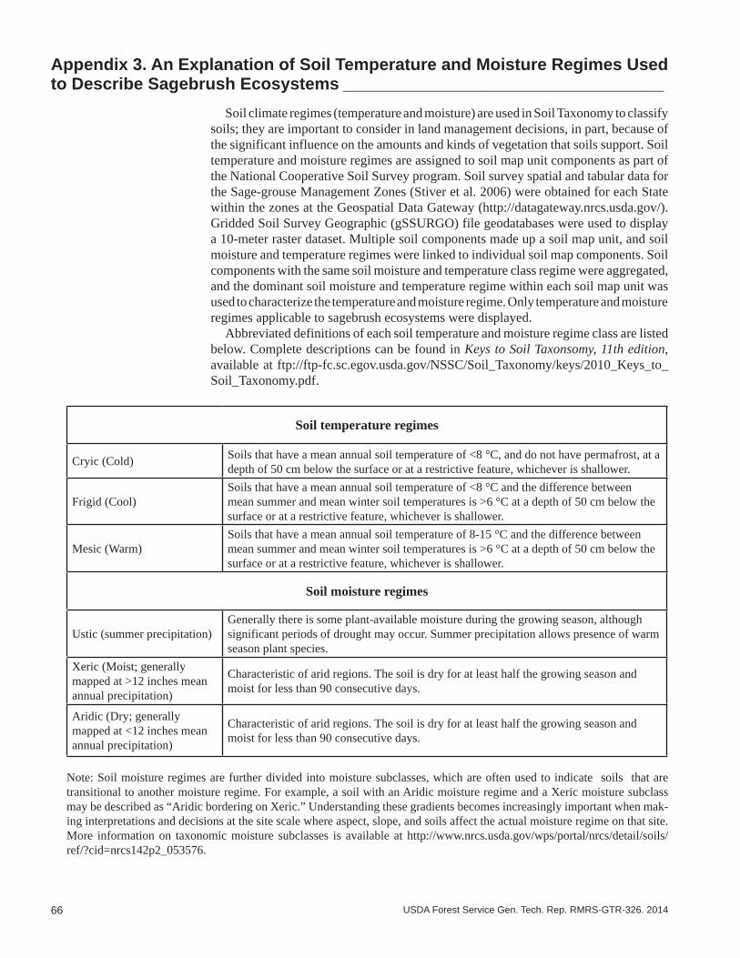
66 USDA Forest Service Gen. Tech. Rep. RMRS-GTR-326. 2014
Appendix 3. An Explanation of Soil Temperature and Moisture Regimes Used to Describe Sagebrush Ecosystems __________________________________
Soil climate regimes (temperature and moisture) are used in Soil Taxonomy to classify soils; they are important to consider in land management decisions, in part, because of the significant influence on the amounts and kinds of vegetation that soils support. Soil temperature and moisture regimes are assigned to soil map unit components as part of the National Cooperative Soil Survey program. Soil survey spatial and tabular data for the Sage-grouse Management Zones (Stiver et al. 2006) were obtained for each State within the zones at the Geospatial Data Gateway (http://datagateway.nrcs.usda.gov/). Gridded Soil Survey Geographic (gSSURGO) file geodatabases were used to display a 10-meter raster dataset. Multiple soil components made up a soil map unit, and soil moisture and temperature regimes were linked to individual soil map components. Soil components with the same soil moisture and temperature class regime were aggregated, and the dominant soil moisture and temperature regime within each soil map unit was used to characterize the temperature and moisture regime. Only temperature and moisture regimes applicable to sagebrush ecosystems were displayed.
Abbreviated definitions of each soil temperature and moisture regime class are listed below. Complete descriptions can be found in Keys to Soil Taxonsomy, 11th edition, available at ftp://ftp-fc.sc.egov.usda.gov/NSSC/Soil_Taxonomy/keys/2010_Keys_to_Soil_Taxonomy.pdf.
Soil temperature regimes
Cryic (Cold) Soils that have a mean annual soil temperature of <8 °C, and do not have permafrost, at a depth of 50 cm below the surface or at a restrictive feature, whichever is shallower.
Frigid (Cool)Soils that have a mean annual soil temperature of <8 °C and the difference between mean summer and mean winter soil temperatures is >6 °C at a depth of 50 cm below the surface or at a restrictive feature, whichever is shallower.
Mesic (Warm)Soils that have a mean annual soil temperature of 8-15 °C and the difference between mean summer and mean winter soil temperatures is >6 °C at a depth of 50 cm below the surface or at a restrictive feature, whichever is shallower.
Soil moisture regimes
Ustic (summer precipitation)Generally there is some plant-available moisture during the growing season, although significant periods of drought may occur. Summer precipitation allows presence of warm season plant species.
Xeric (Moist; generally mapped at >12 inches mean annual precipitation)
Characteristic of arid regions. The soil is dry for at least half the growing season and moist for less than 90 consecutive days.
Aridic (Dry; generally mapped at <12 inches mean annual precipitation)
Characteristic of arid regions. The soil is dry for at least half the growing season and moist for less than 90 consecutive days.
Note: Soil moisture regimes are further divided into moisture subclasses, which are often used to indicate soils that are transitional to another moisture regime. For example, a soil with an Aridic moisture regime and a Xeric moisture subclass may be described as “Aridic bordering on Xeric.” Understanding these gradients becomes increasingly important when mak-ing interpretations and decisions at the site scale where aspect, slope, and soils affect the actual moisture regime on that site. More information on taxonomic moisture subclasses is available at http://www.nrcs.usda.gov/wps/portal/nrcs/detail/soils/ref/?cid=nrcs142p2_053576.
67USDA Forest Service Gen. Tech. Rep. RMRS-GTR-326. 2014
Appendix 4. Data Sources for the Maps in This Report __________________
Dataset Citation Link
Geomac fire perimeters Walters, S.P.; Schneider, N.J.; Guthrie, J.D. 2011. Geospatial Multi-Agency Coordination (GeoMAC) wildland fire perimeters, 2008. Data Series 612. Washington, DC: U.S. Department of the Interior, U.S. Geological Survey.6 p.
http://pubs.er.usgs.gov/publication/ds612
WFDSS fire perimeters Butler, B. B.; Bailey, A. 2013. Disturbance history (Historical wildland fires). Updated 8/9/2013. Wildland Fire Decision Support System. Online: https://wfdss.usgs.gov/wfdss/WFDSS_Home.shtml [Accessed 5 March 2014].
https://wfdss.usgs.gov/wfdss/WFDSS_Home.shtml
or
https://wfdss.usgs.gov/wfdss/WFDSSData_Downloads.shtml
Piñon and juniper land cover
U.S. Geological Survery (USGS) National Gap Analysis Program. 2004. Provisional digital land cover map for the southwestern United States. Version 1.0. Logan, UT: Utah State University, College of Natural Resources, RS/GIS Laboratory.
http://earth.gis.usu.edu/swgap/landcover.html
Piñon and juniper land cover
U.S. Geological Survey (USGS). 2013: LANDFIRE 1.2.0 Existing Vegetation Type layer. Updated 3/13/2013. Washington, DC: U.S. Department of the Interior, Geological Survey. Online: http://landfire.cr.usgs.gov/viewer/. [Accessed 13 March 2014].
http://www.landfire.gov/NationalProductDescriptions21.php
Nevada invasive annual grass index
Peterson, E. B. 2006. A map of invasive annual grasses in Nevada derived from multitemporal Landsat 5 TM imagery. Carson City, NV: State of Nevada, Department of Conservation and Natural Resources, Nevada Natural Heritage Program.
http://heritage.nv.gov/node/167
Owhyee upland annual grass index
Peterson, E. B. 2007. A map of annual grasses in the Owyhee Uplands, Spring 2006, derived from multitemporal Landsat 5 TM imagery. Carson City, NV: State of Nevada, Department of Conservation and Natural Resources, Nevada Natural Heritage Program.
http://heritage.nv.gov/sites/default/files/library/anngrowy_text_print.pdf
Soil data (SSURGO) Soil Survey Staff. 2014a. Soil Survey Geographic (SSURGO) Database. United States Department of Agriculture, Natural Resources Conservation Service. Online: http://sdmdataaccess.nrcs.usda.gov/. [Accessed 3 March 2014a].
http://www.nrcs.usda.gov/wps/portal/nrcs/detail/soils/survey/?cid=nrcs142p2_053627
Soil data (STATSGO) Soil Survey Staff. 2014b. U.S. General Soil Map (STATSGO2) Database. United States Department of Agriculture, Natural Resources Conservation Service. Online: http://sdmdataaccess.nrcs.usda.gov/. [Accessed 3 March 2014b].
68 USDA Forest Service Gen. Tech. Rep. RMRS-GTR-326. 2014
Soil temperature and moisture regime data
Campbell, S. B. 2014. Soil temperature and moisture regime data for the range of greater sage-grouse. Data product. Portland, OR: USDA Natural Resources Conservation Service. Online: https://www.sciencebase.gov/catalog/folder/537f8be5e4b021317a872f1b?community=LC+MAP+-+Landscape+Conservation+Management+and+Analysis+Portal [Accessed 17 June 2014].
https://www.sciencebase.gov/catalog/folder/537f8be5e4b021317a872f1b?community=LC+MAP+-+Landscape+Conservation+Management+and+Analysis+Portal
Sage-grouse management zones
Stiver, S. J.; Apa, A. D.; Bohne, J. R.; Bunnell, S. D.; Deibert, P. A.; Gardner, S. C.; Hilliard, M. A.; McCarthy, C. W.; Schroeder, M. A. 2006. Greater Sage-grouse Comprehensive Conservation Strategy. Unpublished report on file at: Western Association of Fish and Wildlife Agencies, Cheyenne, WY.
Breeding bird densities Doherty, K. E.; Tack, J. D.; Evans, J. S.; Naugle, D. E. 2010. Mapping breeding densities of greater sage-grouse: A tool for range-wide conservation planning. BLM completion report: Agreement # L10PG00911.
http://scholar.google.com/scholar?q=doherty+2010+breeding+bird&hl=en&as_sdt=0&as_vis=1&oi=scholart&sa=X&ei=JqQbU7HUAqfD2QW8xYFY&ved=0CCUQgQMwAA
Sagebrush land cover U.S. Geological Survey (USGS). 2013: LANDFIRE 1.2.0 Existing Vegetation Type layer. Updated 3/13/2013. Washington, DC: U.S. Department of the Interior, Geological Survey. Online: http://landfire.cr.usgs.gov/viewer/. [Accessed 13 March 2014].
http://www.landfire.gov/NationalProductDescriptions21.php
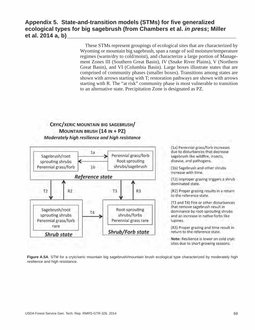
69USDA Forest Service Gen. Tech. Rep. RMRS-GTR-326. 2014
Appendix 5. State-and-transition models (STMs) for five generalized ecological types for big sagebrush (from Chambers et al. in press; Miller et al. 2014 a, b) ____________________________________________________
These STMs represent groupings of ecological sites that are characterized by Wyoming or mountain big sagebrush, span a range of soil moisture/temperature regimes (warm/dry to cold/moist), and characterize a large portion of Manage-ment Zones III (Southern Great Basin), IV (Snake River Plains), V (Northern Great Basin), and VI (Columbia Basin). Large boxes illustrate states that are comprised of community phases (smaller boxes). Transitions among states are shown with arrows starting with T; restoration pathways are shown with arrows starting with R. The “at risk” community phase is most vulnerable to transition to an alternative state. Precipitation Zone is designated as PZ.
Figure A.5A. STM for a cryic/xeric mountain big sagebrush/mountain brush ecological type characterized by moderately high resilience and high resistance.
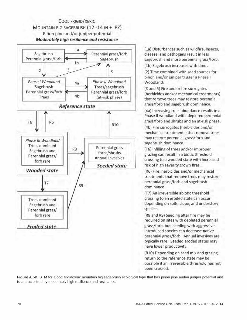
70 USDA Forest Service Gen. Tech. Rep. RMRS-GTR-326. 2014
Figure A.5B. STM for a cool frigid/xeric mountain big sagebrush ecological type that has piñon pine and/or juniper potential and is characterized by moderately high resilience and resistance.
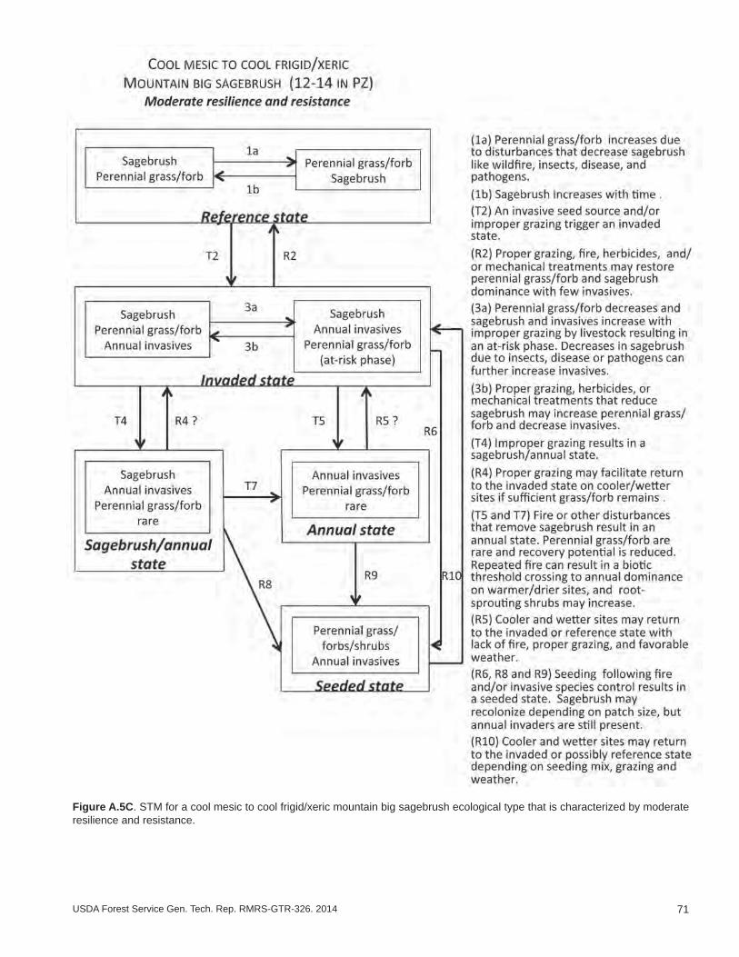
71USDA Forest Service Gen. Tech. Rep. RMRS-GTR-326. 2014
Figure A.5C. STM for a cool mesic to cool frigid/xeric mountain big sagebrush ecological type that is characterized by moderate resilience and resistance.

72 USDA Forest Service Gen. Tech. Rep. RMRS-GTR-326. 2014
Figure A.5D. STM for a cool mesic to warm frigid/xeric mountain big sagebrush ecological type type that has piñon pine and/or juniper potential and is characterized by moderate resilience and moderately low resistance.
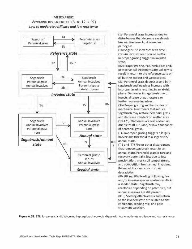
73USDA Forest Service Gen. Tech. Rep. RMRS-GTR-326. 2014
Figure A.5E. STM for a mesic/aridic Wyoming big sagebrush ecological type with low to moderate resilience and low resistance.


The U.S. Department of Agriculture (USDA) prohibits discrimination in all of its programs and activities on the basis of race, color, national origin, age, disability, and where applicable, sex (including gender identity and expression), marital status, familial status, parental status, religion, sexual orientation, political beliefs, genetic information, reprisal, or because all or part of an individual’s income is derived from any public assistance program. (Not all prohibited bases apply to all programs.) Persons with disabilities who require alternative means for communication of program information (Braille, large print, audiotape, etc.) should contact USDA’s TARGET Center at (202) 720-2600 (voice and TDD).
To file a complaint of discrimination, write to: USDA, Assistant Secretary for Civil Rights, Office of the Assistant Secretary for Civil Rights, 1400 Independence Avenue, S.W., Stop 9410, Washington, DC 20250-9410.
Or call toll-free at (866) 632-9992 (English) or (800) 877-8339 (TDD) or (866) 377-8642 (English Federal-relay) or (800) 845-6136 (Spanish Federal-relay). USDA is an equal opportunity provider and employer.
To learn more about RMRS publications or search our online titles:
www.fs.fed.us/rm/publications
www.treesearch.fs.fed.us
Federal Recycling Program Printed on Recycled Paper