usgs national hydrography dataset newsletter · usgs national hydrography dataset newsletter vol....
TRANSCRIPT
USGS National Hydrography Dataset Newsletter Vol. 16, No. 3, March 2017
New Hydrography Cached Map Service
National Hydrography Dataset Plus High Resolution (NHDPlus HR) Update
NHDPlus HR Production Priorities
NHDPlus HR and Ingredient Data Status for Partners
NHDPlus HR Production Status
NHDPlus HR Ingredient Dataset Update - Network Improvement
NHDPlus HR Beta QC Opportunities
NHDPlus HR Ingredient Dataset QC Opportunities
WBD 4- to 8-Digit Hydrologic Unit Name Changes
EleHydro Pilot Project from the Hydrography Side
U.S./Canada Hydrologic Unit Harmonization - St Mary and Belly River
IJC Transboundary Data Harmonization Task Force – Moving Forward
NHD Photo of the Month
NHD Quiz
Upcoming NHD and WBD Calls, Training and Meetings
New Hydrography Cached Map Service Contact: Rob Dollison ( [email protected] )
The USGS is proud to announce the availability of a new cached map service for hydrography, the “USGSHydroCached” service. The new service is designed to act as an “overlay”, displaying hydrography in the familiar USGS topo map symbology, and can be displayed on top of base maps, satellite imagery, or other map services. Because it is cached, the service should perform well at many different scales. The service can be loaded into ArcGIS desktop, ArcGIS Online, or many other interactive mapping applications. The service is available at: https://basemap.nationalmap.gov/arcgis/rest/services/USGSHydroCached/MapServer The previous Hydro Basemap (“USGSHydroNHD”) incorporated a shaded relief basemap, and could not be used as a map overlay (https://basemap.nationalmap.gov/arcgis/rest/services/USGSHydroNHD/MapServer). This old service is outdated and will be removed in the near future after a new, updated hill shade base map is also published. Please also note that the new cached map does not include the Watershed Boundaries Dataset (WBD). The WBD continues to be available in the dynamic National Hydrography Dataset (NHD) web service, and can be added as separate layers if desired: https://services.nationalmap.gov/arcgis/rest/services/nhd/MapServer.
1
A demonstration of the USGSHydroCached service will be given on NHD/WBD Advisory Call on March 14th at 1 pm ET. Please send an email to Becci Anderson ([email protected]) to be added to the NHD/WBD Advisory Call list and calendar invitation.
National Hydrography Dataset Plus High Resolution (NHDPlus HR) Update
NHDPlus HR Production Priorities
Contacts: Ellen Finelli ( [email protected] )
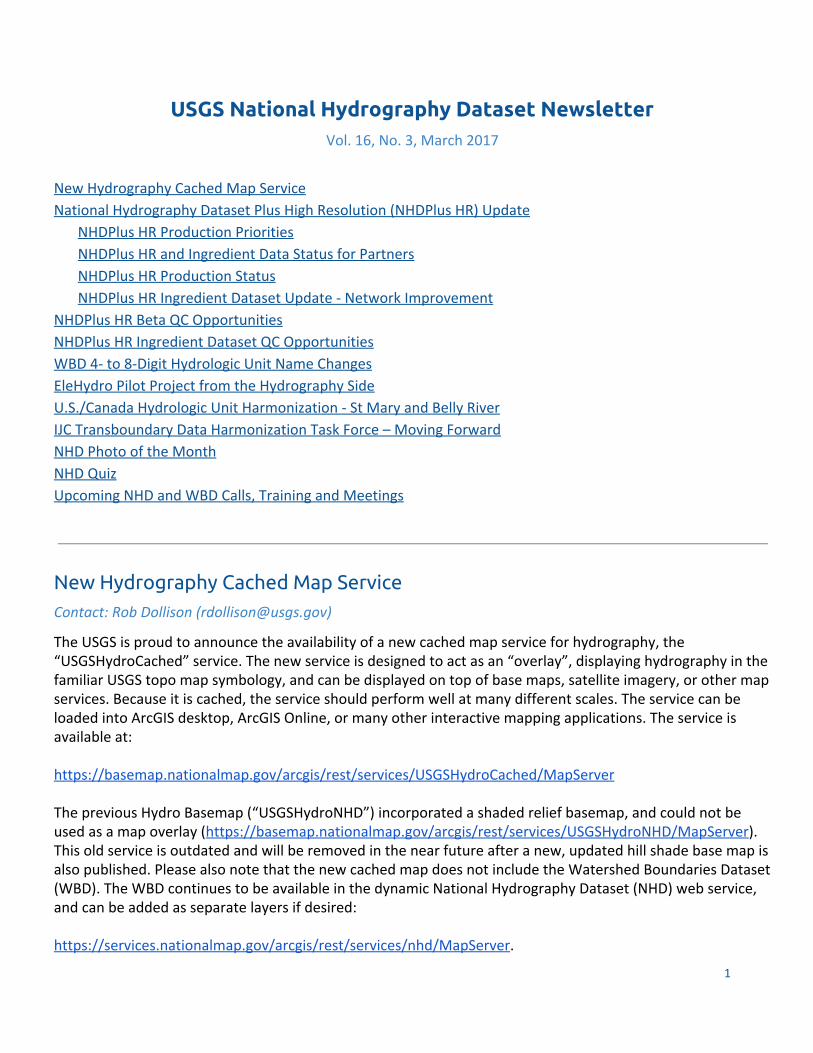
The table below contains the current priority order for creating and refreshing NHDPlus HR datasets over the next few years.
NHDPlus HR Prioritization Schedule
National Hydrography Dataset Newsletter, Vol. 16, No. 3, March 2017 2
NHDPlus HR and Ingredient Data Status for Partners
Contacts: Ellen Finelli ([email protected]), Tatyana Dimascio ( [email protected] )
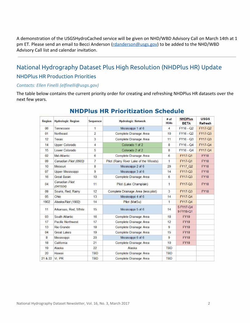
The NHDPlus HR is built from ingredient datasets, including the NHD High Resolution and WBD. For a few months prior to the start of the NHDPlus HR build process, no NHD or WBD data for the region being processed can be checked out for editing. For this reason, we will be communicating monthly regarding the upcoming regions that are closed for editing. The map below displays which areas are available for editing, are closed for editing, and are in NHDPlus HR production. Detailed descriptions of the legend are provided below the map.
Pre-NHDPlus “ACTIVE NHD & WBD Editing” ● The following regions are currently available for editing: 11, 03, 13, 04, 08, 18, 19 and 20. Please ensure
the NHDPlus HR ingredient datasets (NHD and WBD) are ready for the NHDPlus HR build process by performing a detailed QC and edit. Please see the Engage with NHD and WBD NHDPlus HR Ingredient Dataset QC section below for more information.
NHDPlus In Work “Please NO Editing”
● The following regions are currently actively in work for NHDPlus HR preparation - please do not check out this data and refrain from beginning large (long term) jobs: 10, 07, 09, 05. These data need to be available for USGS checkouts to perform quick edits and to support processing NHDPlus in multiple regions simultaneously . We appreciate your support on this matter!
National Hydrography Dataset Newsletter, Vol. 16, No. 3, March 2017 3
NHDPlus Beta QC ● Region 06 and 01 are in work. Region 12 is scheduled next. Beta data are also done for Regions 02, 14,
15, and 16. We encourage those interested in Beta QC of these regions to wait till the release of the Web Markup application later this spring. Please see the Opportunities with NHDPlus HR Beta QC / Pre-NHDPlus HR Refresh section below for more information.
NHDPlus HR Production Status Contact: Ellen Finelli ( [email protected] )
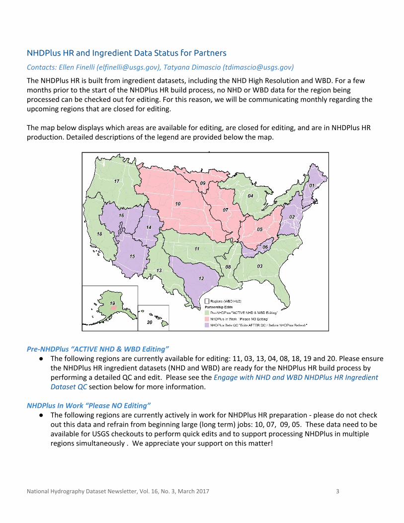
The NHDPlus HR Beta production continues to move forward:
● Hydrologic Regions (HU2s) in production: 10 and 07
● Hydrologic Regions (HU2s) processed: 06, 12, 14, 15, 01, 02, and 16; Region 09 Canadian/US pilot (0903)
● Hydrologic Regions (HU2s) in Beta QC: 06 and 01 in work, 12, 14, 15 and 02 are next
NHDPlus HR Ingredient Dataset Update - Network Improvement
Contact: Hannah Boggs ( [email protected] )
The NGTOC continues its focus on the Network Improvement Project with the goal of identifying and correcting network and data quality issues present in the high resolution NHD. One of the key drivers for this effort is the need to provide data ready to use for the production of NHDPlus HR. Coordination with appropriate NHD POC’s will begin prior to review. Please see status information for details.
National Hydrography Dataset Newsletter, Vol. 16, No. 3, March 2017 4
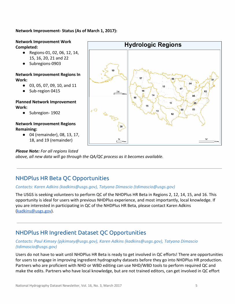
Network Improvement- Status (As of March 1, 2017): Network Improvement Work Completed:
● Regions-01, 02, 06, 12, 14, 15, 16, 20, 21 and 22
● Subregions-0903 Network Improvement Regions In Work:
● 03, 05, 07, 09, 10, and 11 ● Sub-region 0415
Planned Network Improvement Work:
● Subregion- 1902 Network Improvement Regions Remaining:
● 04 (remainder), 08, 13, 17, 18, and 19 (remainder)
Please Note: For all regions listed above, all new data will go through the QA/QC process as it becomes available.
NHDPlus HR Beta QC Opportunities Contacts: Karen Adkins ( [email protected] ), Tatyana Dimascio ([email protected])
The USGS is seeking volunteers to perform QC of the NHDPlus HR Beta in Regions 2, 12, 14, 15, and 16. This opportunity is ideal for users with previous NHDPlus experience, and most importantly, local knowledge. If you are interested in participating in QC of the NHDPlus HR Beta, please contact Karen Adkins ([email protected]).
NHDPlus HR Ingredient Dataset QC Opportunities Contacts: Paul Kimsey ([email protected]), Karen Adkins ( [email protected] ), Tatyana Dimascio ([email protected])
Users do not have to wait until NHDPlus HR Beta is ready to get involved in QC efforts! There are opportunities for users to engage in improving ingredient hydrography datasets before they go into NHDPlus HR production. Partners who are proficient with NHD or WBD editing can use NHD/WBD tools to perform required QC and make the edits. Partners who have local knowledge, but are not trained editors, can get involved in QC effort
National Hydrography Dataset Newsletter, Vol. 16, No. 3, March 2017 5
during the release of the Markup application later this spring. For more information on getting involved with improving ingredient NHD and WBD datasets, please contact Karen Adkins ([email protected]) or Paul Kimsey ([email protected]).
WBD 4- to 8-Digit Hydrologic Unit Name Changes Contacts: Elizabeth Stevens-Klein ( [email protected] ), Susan Buto ( [email protected] ), and Kimberly Jones ( [email protected] )
Names at the 2- to 8-digit hydrologic unit levels in WBD originate from USGS Water Supply Paper 2294 (https://pubs.usgs.gov/wsp/wsp2294/), which outlined the first approved boundaries, names, and numerical codes for these hydrologic units. For example, an 8-digit hydrologic unit might have the name “Apple” instead of “Apple Creek”. This is not in alignment with the Federal Standards and Procedures for the National Watershed Boundary Dataset (https://pubs.usgs.gov/tm/11/a3/) and is inconsistent with names in the Geographic Names Information System (GNIS) that hydrologic units are named after. Names at the 10- to 14-digit levels do have the hydrographic feature type included with the name (e.g. “Apple Creek”) and match the GNIS name of the feature the hydrologic unit is named after. The inconsistency in naming protocols has caused confusion. The WBD technical coordination team and WBD State Stewardship Work Group have discussed reviewing and adjusting all 4- to 8-digit names to reflect what is stored in GNIS and to make all WBD hydrologic units consistent, coherent, and aligned with the Federal Standards. A name review of the 4- to 8-digit units may reveal other inconsistencies with the current standard, which would also be addressed. Names for the 2-digit units will not be modified as they reflect regional names (e.g. “Missouri Region”). Attribution changes to the 4- to 8-digit units are significant and must be carefully thought out. If you have comments or questions regarding how name changes would cause issues with tools, processes, legal documentation, or other associated systems, please contact Elizabeth Stevens-Klein ([email protected]) on or before May 31, 2017. These potential changes will be discussed with the community before making a decision to proceed. Please note: if the decision is made to move forward, we will coordinate with State Stewards regarding all changes.
EleHydro Pilot Project from the Hydrography Side Contact: David Anderson ([email protected])
The USGS has undertaken a pilot project to help understand the level of effort necessary to generate lidar-derived hydrography at three, incrementally more detailed levels of quality across varied landscapes, and also to provide feedback on the current EleHydro data model. The project investigates requirements and methods for standardized breakline data collection that are optimal, cost-effective, and achieve a high level of vertical integration between the National Hydrography Dataset and 3D Elevation Program (3DEP) digital elevation data. Breaklines are developed using elevation models and are used to represent distinct
National Hydrography Dataset Newsletter, Vol. 16, No. 3, March 2017 6
interruptions of the surface slope such as eroded or man-made drainage features or bank edges around waterbodies. The project assesses methods for improving the horizontal accuracy of the 1:24,000-scale NHD, creating new hydrographic 1D features at the 1:5,000-scale, and for type coding hydrography features using lidar terrains. The study areas include five 10-digit hydrologic units in varying physiographic areas where lidar data is available . Deliveries produced for the pilot project will follow the specifications outlined in the U.S. Geological Survey National Geospatial Program Lidar Base Specification Version 1.2 (https://pubs.usgs.gov/tm/11b4/pdf/tm11-B4.pdf), and the NHD Feature Catalog (https://nhd.usgs.gov/userGuide/Robohelpfiles/NHD_User_Guide/Feature_Catalog/NHD_Feature_Catalog.htm). The EleHydro model specification is in the early development stages and is evolving based on reviews by a team of USGS Water Community of Use (COU) liaisons and Elevation and Hydrography team members. The EleHydro model has been designed with attention to breaklines and surface features that are necessary in both the terrain and hydrography models. Some concerns about using only one form of remotely sensed data to determine hydrography features have been addressed. Using just lidar (elevation) does not always lead to suitable hydrography determination and the model doesn’t contain subsurface features necessary for network connectivity such as pipeline and karst features. Periodicity is another consideration; however, in the current project the improvement on 1:24,000-scale data includes carrying over the periodicity from previous features. New features are being classified using orthoimagery and/or additional modeling processes, but in most cases are being identified as generic streams or canal/ditch features. The deliverables from this project include a dataset that can be input to the NHD GeoConflation process. This data will be reviewed extensively by USGS and, if acceptable, will be presented to the state stewards in the pilot project area for possible inclusion in the NHD production data. It has not yet been determined if the delivery data will be acceptable as a final product by all stakeholders. Review of the extracted hydro features concurrent with the NHD data model and upholding base quality assurance standards are high priorities in this pilot. The ability to develop a successful hydro network from lidar-derived terrain is a primary driver to EleHydro. Members of the EleHydro Pilot review group include: Karen Adkins, David Anderson , Christy-Ann Archuleta, Silvia Terziotti, Karl Heidemann, Robert Wheelwright, and Steve Aichele.
Canada-U.S. Hydrologic Unit Harmonization - St Mary and Belly River Contact: Kimberly Jones ( [email protected] ), Judy Kwan ([email protected])
Over the last 10 years, the International Joint Commission (IJC) Hydrographic Data Harmonization Task force has been tasked with creating harmonized hydrography and hydrologic units for the international border area, which includes cross-border 8-digit (Canadian 4-digit) hydrologic units. The task force is pleased to announce that development of harmonized 10- and 12-digit hydrologic units for the St Mary and Belly River units has been completed. This is the final phase of the project for these areas.
National Hydrography Dataset Newsletter, Vol. 16, No. 3, March 2017 7
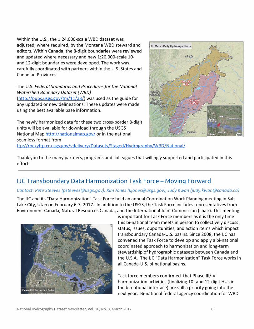
Within the U.S., the 1:24,000-scale WBD dataset was adjusted, where required, by the Montana WBD steward and editors. Within Canada, the 8-digit boundaries were reviewed and updated where necessary and new 1:20,000-scale 10- and 12-digit boundaries were developed. The work was carefully coordinated with partners within the U.S. States and Canadian Provinces. The U.S. Federal Standards and Procedures for the National Watershed Boundary Dataset (WBD) (http://pubs.usgs.gov/tm/11/a3/) was used as the guide for any updated or new delineations. These updates were made using the best available base information. The newly harmonized data for these two cross-border 8-digit units will be available for download through the USGS National Map http://nationalmap.gov/ or in the national seamless format from ftp://rockyftp.cr.usgs.gov/vdelivery/Datasets/Staged/Hydrography/WBD/National/. Thank you to the many partners, programs and colleagues that willingly supported and participated in this effort.
IJC Transboundary Data Harmonization Task Force – Moving Forward Contact: Pete Steeves ( [email protected] ), Kim Jones ([email protected]), Judy Kwan ([email protected])
The IJC and its “Data Harmonization” Task Force held an annual Coordination Work Planning meeting in Salt Lake City, Utah on February 6-7, 2017. In addition to the USGS, the Task Force includes representatives from Environment Canada, Natural Resources Canada, and the International Joint Commission (chair). This meeting
is important for Task Force members as it is the only time this bi-national team meets in person to collectively discuss status, issues, opportunities, and action items which impact transboundary Canada-U.S. basins. Since 2008, the IJC has convened the Task Force to develop and apply a bi-national coordinated approach to harmonization and long-term stewardship of hydrographic datasets between Canada and the U.S.A. The IJC “Data Harmonization” Task Force works in all Canada-U.S. bi-national basins. Task force members confirmed that Phase III/IV harmonization activities (finalizing 10- and 12-digit HUs in the bi-national interface) are still a priority going into the next year. Bi-national federal agency coordination for WBD
National Hydrography Dataset Newsletter, Vol. 16, No. 3, March 2017 8
reviews with bordering U.S. States and Canadian Provinces are being scheduled for the international Lake Champlain/Richelieu interface and the international Great Lakes. Input and guidance from the IJC both present and via teleconference, identified that more Task Force time will be required to improve the usability of the harmonized data including communication products for the bi-national water user. The IJC Task Force has embraced early developments of a new Confluence shared wiki space, spawning a USA-Canada Hydro Data Harmonization (HDH) shared space to meet the growing needs of this bi-national water community of practice. It is understood that this wiki is a work in progress and the Task Force will continue to shape it over the next year for various bi-national water communities. Finally, the Task Force agreed to prioritize the the international Lake Champlain/Richelieu basin for the IJC and as the Task Force and “data harmonization” moves forward. Please contact any Task Force member listed in the contacts above or Michael Laitta ([email protected]) for more information.
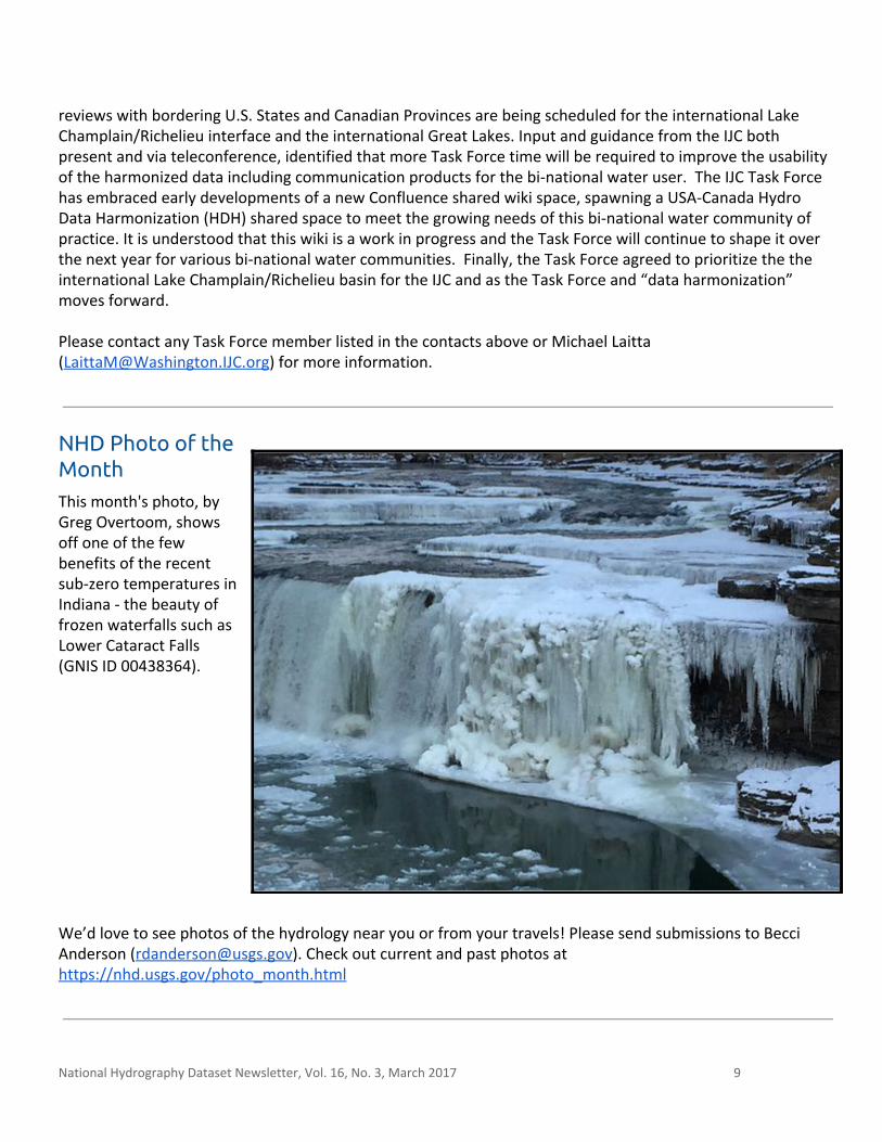
NHD Photo of the Month This month's photo, by Greg Overtoom, shows off one of the few benefits of the recent sub-zero temperatures in Indiana - the beauty of frozen waterfalls such as Lower Cataract Falls (GNIS ID 00438364).
We’d love to see photos of the hydrology near you or from your travels! Please send submissions to Becci Anderson ([email protected]). Check out current and past photos at https://nhd.usgs.gov/photo_month.html
National Hydrography Dataset Newsletter, Vol. 16, No. 3, March 2017 9
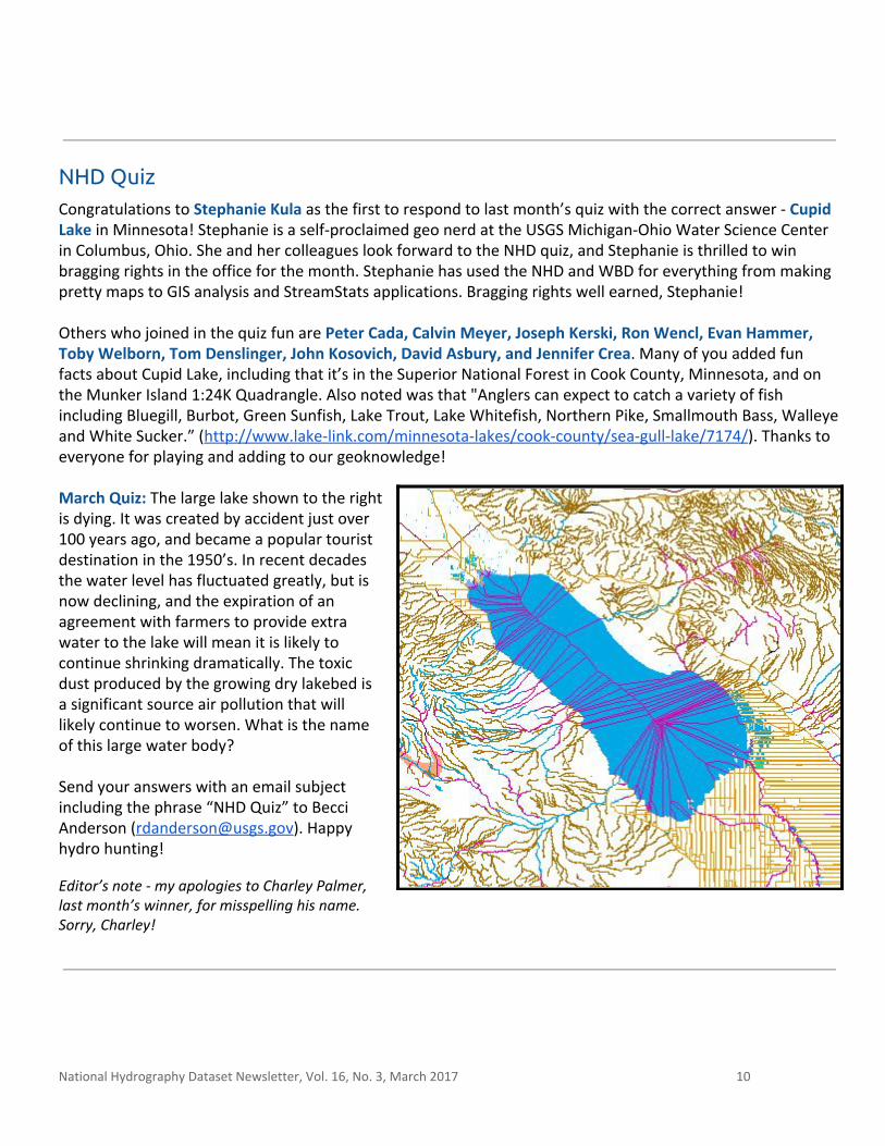
NHD Quiz Congratulations to Stephanie Kula as the first to respond to last month’s quiz with the correct answer - Cupid Lake in Minnesota! Stephanie is a self-proclaimed geo nerd at the USGS Michigan-Ohio Water Science Center in Columbus, Ohio. She and her colleagues look forward to the NHD quiz, and Stephanie is thrilled to win bragging rights in the office for the month. Stephanie has used the NHD and WBD for everything from making pretty maps to GIS analysis and StreamStats applications. Bragging rights well earned, Stephanie! Others who joined in the quiz fun are Peter Cada, Calvin Meyer, Joseph Kerski, Ron Wencl, Evan Hammer, Toby Welborn, Tom Denslinger, John Kosovich, David Asbury, and Jennifer Crea. Many of you added fun facts about Cupid Lake, including that it’s in the Superior National Forest in Cook County, Minnesota, and on the Munker Island 1:24K Quadrangle. Also noted was that "Anglers can expect to catch a variety of fish including Bluegill, Burbot, Green Sunfish, Lake Trout, Lake Whitefish, Northern Pike, Smallmouth Bass, Walleye and White Sucker.” (http://www.lake-link.com/minnesota-lakes/cook-county/sea-gull-lake/7174/). Thanks to everyone for playing and adding to our geoknowledge! March Quiz: The large lake shown to the right is dying. It was created by accident just over 100 years ago, and became a popular tourist destination in the 1950’s. In recent decades the water level has fluctuated greatly, but is now declining, and the expiration of an agreement with farmers to provide extra water to the lake will mean it is likely to continue shrinking dramatically. The toxic dust produced by the growing dry lakebed is a significant source air pollution that will likely continue to worsen. What is the name of this large water body? Send your answers with an email subject including the phrase “NHD Quiz” to Becci Anderson ([email protected]). Happy hydro hunting!
Editor’s note - my apologies to Charley Palmer, last month’s winner, for misspelling his name. Sorry, Charley!
National Hydrography Dataset Newsletter, Vol. 16, No. 3, March 2017 10
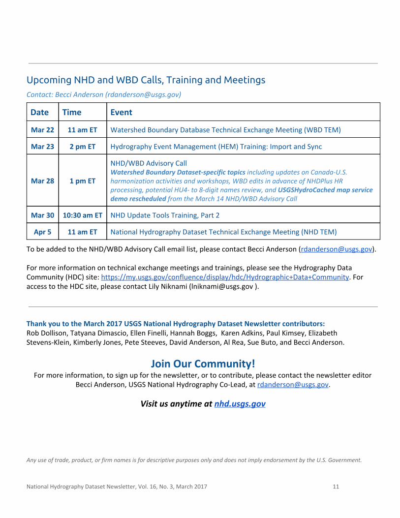
Upcoming NHD and WBD Calls, Training and Meetings Contact: Becci Anderson ( [email protected] )
Date Time Event
Mar 22 11 am ET Watershed Boundary Database Technical Exchange Meeting (WBD TEM)
Mar 23 2 pm ET Hydrography Event Management (HEM) Training: Import and Sync
Mar 28 1 pm ET
NHD/WBD Advisory Call Watershed Boundary Dataset-specific topics including updates on Canada-U.S. harmonization activities and workshops, WBD edits in advance of NHDPlus HR processing, potential HU4- to 8-digit names review, and USGSHydroCached map service demo rescheduled from the March 14 NHD/WBD Advisory Call
Mar 30 10:30 am ET NHD Update Tools Training, Part 2
Apr 5 11 am ET National Hydrography Dataset Technical Exchange Meeting (NHD TEM)
To be added to the NHD/WBD Advisory Call email list, please contact Becci Anderson ([email protected]). For more information on technical exchange meetings and trainings, please see the Hydrography Data Community (HDC) site: https://my.usgs.gov/confluence/display/hdc/Hydrographic+Data+Community. For access to the HDC site, please contact Lily Niknami ([email protected] ).
Thank you to the March 2017 USGS National Hydrography Dataset Newsletter contributors: Rob Dollison, Tatyana Dimascio, Ellen Finelli, Hannah Boggs, Karen Adkins, Paul Kimsey, Elizabeth Stevens-Klein, Kimberly Jones, Pete Steeves, David Anderson, Al Rea, Sue Buto, and Becci Anderson.
Join Our Community! For more information, to sign up for the newsletter, or to contribute, please contact the newsletter editor
Becci Anderson, USGS National Hydrography Co-Lead, at [email protected].
Visit us anytime at nhd.usgs.gov Any use of trade, product, or firm names is for descriptive purposes only and does not imply endorsement by the U.S. Government.
National Hydrography Dataset Newsletter, Vol. 16, No. 3, March 2017 11