indiana national hydrography dataset (nhd) improvement and application workshop nhd local-resolution...
TRANSCRIPT

Indiana National Hydrography Dataset (NHD) Improvement and Application Workshop
NHD Local-Resolution Development

Coordination of Indiana GIS through dissemination of data and data products, education and outreach, adoption of standards, and building partnerships
Agenda
• Background Pilot Study
• Approach• Project Tasks
Conversion Conflation
• Demo• Status / Next
Steps

Coordination of Indiana GIS through dissemination of data and data products, education and outreach, adoption of standards, and building partnerships
Background
• Working closely with IGIC Waters Workgroup to develop Local-Resolution NHD for the State of Indiana Product must meet USGS NHD capture
standards Loaded into USGS National Map and
IndianaMap upon QC and approval More detailed hydrography, more
accurate spatial locations All attributes that currently exist in the
1:24K NHD will be transferred (conflated)

Coordination of Indiana GIS through dissemination of data and data products, education and outreach, adoption of standards, and building partnerships
Background
Small watershed in Hamilton County (Morse Reservoir and agricultural land)
Broad representation of the water features to be included in the statewide project
Designed to provide a basis for stream location accuracy and upstream drainage area limit assessments No 1:24K NHD attributes conflated
Written report of findings
Pilot study conducted in Summer 2009
Coordination of Indiana GIS through dissemination of data and data products, education and outreach, adoption of standards, and building partnerships
Background
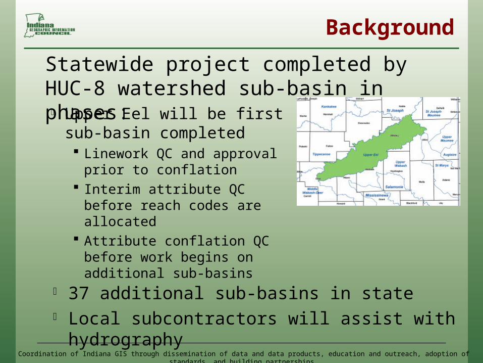
Upper Eel will be first sub-basin completed Linework QC and approval
prior to conflation Interim attribute QC before
reach codes are allocated Attribute conflation QC
before work begins on additional sub-basins
Statewide project completed by HUC-8 watershed sub-basin in phases:
37 additional sub-basins in state Local subcontractors will assist with
hydrography

Coordination of Indiana GIS through dissemination of data and data products, education and outreach, adoption of standards, and building partnerships
Approach
5 feature classes created NHDFlowline (Stream/River,
Canal/Ditch, Artificial Path) NHDWaterbody (Lake/Pond,
Swamp/Marsh, Reservior) NHDArea (Large
Stream/River, Large Canal/Ditch)
NHDPoint (Gaging Station, Well)
NHDLine (Dams)
• Creation of local-resolution hydrography

Coordination of Indiana GIS through dissemination of data and data products, education and outreach, adoption of standards, and building partnerships
Approach
• 6 acre upstream drainage limit• Features digitized from orthoimagery
and elevation data
• 1:24K NHD attribute conflation – NHD attribute population for new features

Coordination of Indiana GIS through dissemination of data and data products, education and outreach, adoption of standards, and building partnerships
Approach
• Base Data Imagery
2005 one foot and/or half foot pixel RGB orthophotography
Terrain (Contours, DEMs, Hillshades) 2005 five foot cell size DEM (ISTAR)
Supplemented by newer and/or more accurate local data where available

Coordination of Indiana GIS through dissemination of data and data products, education and outreach, adoption of standards, and building partnerships
Approach
• Reference Files Local Hydrography provided by the
State National Wetlands Inventory (NWI) INDNR Dams DOT Bridges 1:24K NHD Karst Dyelines

Coordination of Indiana GIS through dissemination of data and data products, education and outreach, adoption of standards, and building partnerships
Project Tasks - Conversion
1. Hydro-correct elevation data Generate 6 acre basins and streams
for reference (guidance for upstream limits and stream location)
Generate contours, DEMs, hillshades for reference

Coordination of Indiana GIS through dissemination of data and data products, education and outreach, adoption of standards, and building partnerships
Project Tasks - Conversion
2. Digitize NHD features Create 1:2,400 or 1:1,200 scale hydrography
layer (dependent upon imagery source) to the 6 acre upstream drainage limit
Imagery will be primary source for data conversion, terrain data used where features are not visible
1:24K NHD used as reference to ensure all features from the 1:24K NHD have been incorporated
Hydrography edge-matched to 1:24K NHD along state borders

Coordination of Indiana GIS through dissemination of data and data products, education and outreach, adoption of standards, and building partnerships
Project Tasks - Conversion• Business Rules
NHDFlowline If 1:24K flowline extends
further upstream than 6 acres, it will be maintained
If features from 1:24K flowline no longer visible, not included in local resolution dataset
If feature is less than 20 feet wide and less than 600 feet long it will be captured as a flowline

Coordination of Indiana GIS through dissemination of data and data products, education and outreach, adoption of standards, and building partnerships
Project Tasks - Conversion
• Business Rules NHDArea
If feature is more than 20 feet wide and more than 600 feet long it will be captured as an area
All 1:24K NHDAreas will be retained if the feature is visible in the imagery
Coordination of Indiana GIS through dissemination of data and data products, education and outreach, adoption of standards, and building partnerships
Project Tasks - Conversion
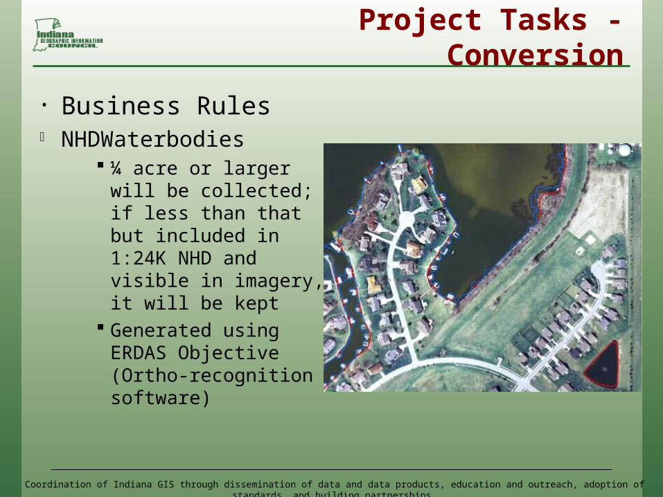
• Business Rules NHDWaterbodies
¼ acre or larger will be collected; if less than that but included in 1:24K NHD and visible in imagery, it will be kept
Generated using ERDAS Objective (Ortho-recognition software)

Coordination of Indiana GIS through dissemination of data and data products, education and outreach, adoption of standards, and building partnerships
Project Tasks - Conversion
• Business Rules NHDPoints – no new features added,
copy over and adjust existing 1:24K NHD features as necessary
NHDLines – new features added if found in reference files (dams), will also copy over and adjust existing 1:24K NHD features as necessary

Coordination of Indiana GIS through dissemination of data and data products, education and outreach, adoption of standards, and building partnerships
Project Tasks - Conversion
3. Prep data for conflation• The NHDinGeo version 2.0
database schema will be used• Combination of USGS scripts,
and ArcGIS 9.3 tools to check: Topology Flow direction FCode population Artificial paths Connectors

Coordination of Indiana GIS through dissemination of data and data products, education and outreach, adoption of standards, and building partnerships
Project Tasks - Conflation
USGS NHD GeoConflation Toolset
Reach codes, GNIS info conflated from 1:24K NHD, and generated for new features using the USGS NHD tools
Intermittent/Perennial designations conflated for1:24K attributes only
4. Conflation of1:24K NHD attributes and data population for new features

Coordination of Indiana GIS through dissemination of data and data products, education and outreach, adoption of standards, and building partnerships
Project Tasks - Conflation
Most performed through NHD GeoConflation queues at various stages After permanent reach codes
assigned, checks for gapped or branched reach codes
Checks for gapped or branched GNIS names
Subsequent processing steps cannot proceed until potential problems have been resolved
Quality Control of conflated attributes:
* Close coordination with and approval by USGS

Coordination of Indiana GIS through dissemination of data and data products, education and outreach, adoption of standards, and building partnerships
Project Tasks - Conflation
• Waters Workgroup will check out 1:24K NHD sub-basins as conflation occurs to avoid any other edits being made to the sub-basin
• Feature level, FGDC compliant metadata generated for each sub-basin

Coordination of Indiana GIS through dissemination of data and data products, education and outreach, adoption of standards, and building partnerships
Demo

Coordination of Indiana GIS through dissemination of data and data products, education and outreach, adoption of standards, and building partnerships
Status / Next Steps
• Status Completed conflation training with USGS Base data received for Upper Eel pilot area
• Next Steps Complete conversion and conflation tasks
for Upper Eel pilot area 3 iterations of QC performed by Indiana’s QC
team Prioritize work, outline schedule for
remaining sub-basins Train and engage subcontractors

Coordination of Indiana GIS through dissemination of data and data products, education and outreach, adoption of standards, and building partnerships
Questions and Answers