use case of disaster management system by using geopaparazzi and mapguide open source
TRANSCRIPT

1
Use case of Disaster Management System by using Geopaparazzi and
MapGuide Open Source
Hirofumi Hayashi, Venkatesh Raghavan, Kozawa Hiroshi
FOSS4G2015 Seoul SESSION 9-3: Disaster and Disease

2
Contents 1. Introduction 2. Conventional DMIS issues 3. Features of DMIS of OWGS 4. Expansion of DMIS for higher availability 5. Conclusions
DMIS: Disaster Management Information System OWGS: Osaka Water General Service

3
1. Introduction Ø Disaster events

4
1. Introduction Ø Disaster events
http://www.theatlantic.com/

5
1. Introduction Ø Disaster events
http://www.theatlantic.com/ http://www.theatlantic.com/

6
1. Introduction
DMIS: Disaster Management Information System
Ø Need to collect information, set priories, and take quick action for restoration
Ø Effectiveness of DMIS
Collection of various information for quick grasp of field situation to support better decision.

7
2. Conventional DMIS issues
DMIS: Disaster Management Information System
1. Operation is difficult. 2. High cost is involved. 3. System may not be available online due to
network outages or server trouble.

8
3. Features of DMIS of OWGS • User-friendly interface
Easily usable in emergency situations
Network secured at time of disaster
Development and maintenance costs are minimal
• System based on general-purpose PC, general-purpose software, and OSS
• Use of MCA for data transmission
OSS: Open Source Software MCA: Multi Channel Access

9
MapServer OUTPUT
Disaster Management Headquarters
Relief Site
Water Treatment Plant
check
Emergency Water Supply
input
Public Information
DATA
instructions
instructions
DMIS Concept Diagram DATA (files)
Server

10
• All server functions are implemented with OSS. • OSS enables customization, and can be obtained
free of charge.
Server prototype
OSS: Open Source Software

3.The feature of DMIS of OWGS
Users Hardware Software Network
Clients Office Staff
• General-purpose PC • Stationary type MCA
• Microsoft Office Suite • File transfer software for MCA
Intranet or MCA
Field Staff • Portable MCA MCA
Servers Disaster Management Headquaters
• General-purpose PC • Stationary type MCA
• Apache (Web Server) • MapServer (Web Mapping Engine) • PostgreSQL (Database) • PostGIS (Spatial DB Extension) • File transfer software for MCA • GPS and Menu Management for MCA
Intranet or MCA
System Components (Old)

12
4. Expansion of DMIS for Higher Availability Client: Smart-phone Server: Cloud computing

13
Inspection
Emergency water supply
CLOUD
Image of New DMIS
Disaster Management Headquarters and Offices
Emergency restoration

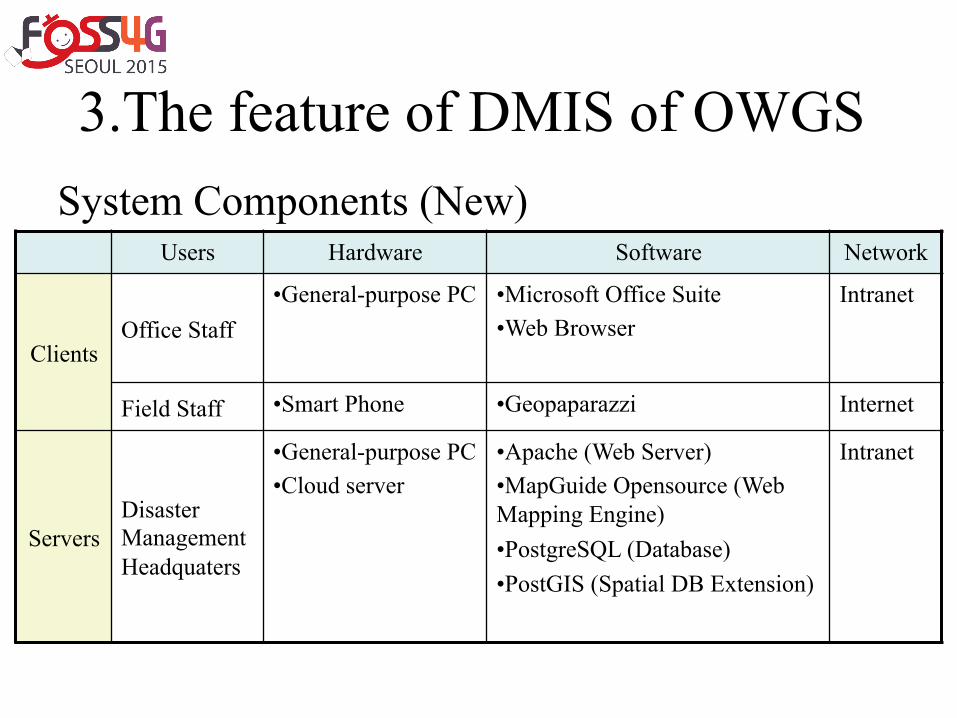
3.The feature of DMIS of OWGS
Users Hardware Software Network
Clients Office Staff
• General-purpose PC • Microsoft Office Suite • Web Browser
Intranet
Field Staff • Smart Phone • Geopaparazzi Internet
Servers Disaster Management Headquaters
• General-purpose PC • Cloud server
• Apache (Web Server) • MapGuide Opensource (Web Mapping Engine) • PostgreSQL (Database) • PostGIS (Spatial DB Extension)
Intranet
System Components (New)

Client (Smart-Phone)
Server
Internet 地理院地図 Google Bing Yahoo ・・・
Android
Geopaparazzi (Customize)
Linux
Apache(web)
Postgresql(DB)
MapGuide Opensource (GIS)
Postgis POST
KML
WMS

16
New Inspection Edit Inspection data
Map
Transmit Inspection data
GPS log
Update Inspection item
Initial Screen (Smart Phone)

17
Pipeline trouble
Easy Reporting

18
Input Screen

19
Map

20
Easy Operation (1) Number
Modified user interface of Geopaparazzi (2) Color (3)BigFont

21
Map (only) on PC Browser

22
Pipeline Layer added

23
Report Layer added

24
Workflow of Water Treatment

25
Valve Search

26
Water leak survey report

27

28
5. Conclusions • DMIS of OWGS
– High availability and high usability at lower cost – Available not only during disaster situations but
also for everyday water service operations – Can be customized easily and flexibly
• Facility/pipeline information management • Water meter reading

29
Thank you for your kind attention.
ACKNOWLEDGEMENTS • Professor Venkatesh Raghavan (OCU) • Associate Professor Daisuke Yoshida (OCU) • Associate Professor Go Yonezawa (OCU) • Kozawa Hiroshi (OWGS) • Takuya Yamamoto, Takuya Motomochi ,
Takuya Morioka (OCU students), • Naoki Ueda(Locazing Inc), Daniel Kastl(Georepublic),
Gerald Fenoy(GeoLabs SARL)

Reference

3.The feature of DMIS of OWGS
Users Hardware Software Network
Clients Office Staff
• General-purpose PC • Stationary type MCA
• Microsoft Office Suite • File transfer software for MCA
Intranet or MCA
Field Staff • Portable MCA MCA
Servers Disaster Management Headquaters
• General-purpose PC • Stationary type MCA
• Apache (Web Server) • MapServer (Web Mapping Engine) • PostgreSQL (Database) • PostGIS (Spatial DB Extension) • File transfer software for MCA • GPS and Menu Management for MCA
Intranet or MCA
System Components (Old)
3.The feature of DMIS of OWGS
Users Hardware Software Network
Clients Office Staff
• General-purpose PC • Microsoft Office Suite • Web Browser
Intranet
Field Staff • Smart Phone • Geopaparazzi Internet
Servers Disaster Management Headquaters
• General-purpose PC • Cloud server
• Apache (Web Server) • MapGuide Opensource (Web Mapping Engine) • PostgreSQL (Database) • PostGIS (Spatial DB Extension)
Intranet
System Components (New)

MapGuide Open Source
33
MapGuide Open Source 3.0 released

MapGuide Open Source
34
• Easy to use DWG(Readonly as DWF) • Interactive Map Viewing • Quality Cartographic Output • Built-in Resource Database for Manageability • Uniform Data Access
https://mapguide.osgeo.org/features.html