1 © 2008 gis perfect ltd. - autodesk mapguide enterprise autodesk mapguide enterprise 2008 gis...
TRANSCRIPT

1
© 2008 GIS Perfect Ltd. - Autodesk MapGuide Enterprise
Autodesk MapGuide Enterprise 2008
GIS Perfect Ltd.

2© 2006 Autodesk
The World’s Leading 2D and 3D Software Company
We are a Fortune 1000 company
100% of the Fortune 100 use our products
7 million registered users around the world
An unsurpassed partner network
More than 2,500 third-party developers

3
© 2008 GIS Perfect Ltd. - Autodesk MapGuide Enterprise
Communication & Utilities
Engineering & Construction Government
Transportation
Infrastructure IndustryCustomers Manage Large, Complex Infrastructure Systems
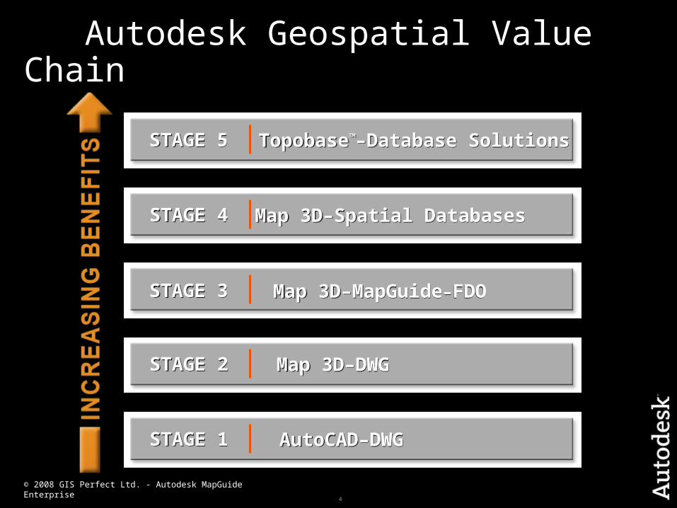
4
© 2008 GIS Perfect Ltd. - Autodesk MapGuide Enterprise
Autodesk Geospatial Value Chain
STAGE 5STAGE 5 Topobase™–Database SolutionsTopobase™–Database Solutions
STAGE 4STAGE 4 Map 3D–Spatial DatabasesMap 3D–Spatial Databases
STAGE 3STAGE 3 Map 3D–MapGuide–FDOMap 3D–MapGuide–FDO
STAGE 2STAGE 2 Map 3D–DWGMap 3D–DWG
STAGE 1STAGE 1 AutoCAD–DWGAutoCAD–DWG
5
© 2008 GIS Perfect Ltd. - Autodesk MapGuide Enterprise
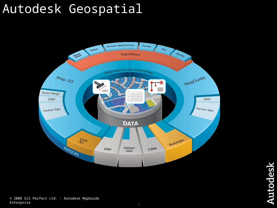
Autodesk Geospatial

6
Autodesk Geospatial
EngineeringCAD
PlanningGIS
7
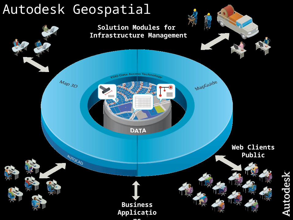
Autodesk Geospatial
Web ClientsPublic
BusinessApplications
Solution Modules for Infrastructure Management

8
Autodesk MapGuide EnterpriseYour fastest way to the web
A powerful mapping platform
for delivering CAD and GIS information
quickly, easily, and cost-effectively
via the web.
9
Why deliver information on the web?
Improve business performance, reduce costs, increase customer satisfaction, meet regulatory requirements
Manage GIS & CAD as part of an IT portfolio
Get information to where it is needed Reach the maximum number of users Get the right data to the right people at the right time Enable participation across the organization Get data off the desktop and out of departmental data silos Integrate with other business systems
10
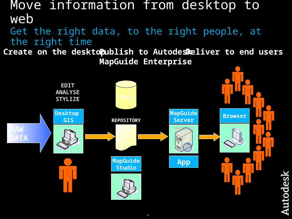
Move information from desktop to webGet the right data, to the right people, at the right time
RAWDATA
`
Desktop GIS
Browser
DATA
`
MapGuideStudio
REPOSITORY
Publish to Autodesk MapGuide Enterprise
Create on the desktop Deliver to end users
MapGuideServer
App
EDITANALYSESTYLIZE
11
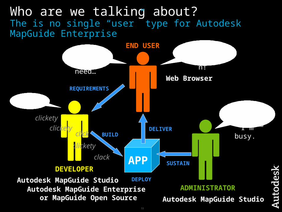
Who are we talking about?The is no single “user” type for Autodesk MapGuide Enterprise
APP
Autodesk MapGuide Studio
Web Browser
Autodesk MapGuide StudioAutodesk MapGuide Enterprise
or MapGuide Open Source
END USER
DEVELOPER
ADMINISTRATOR
“I have a
need…”
“I love my application!
”
“Sure!”
clicketyclickety
clickety
click
clack
“Go away,
I’m busy.”
REQUIREMENTS
BUILDDELIVER
DEPLOY
SUSTAIN

12
What do they value?Each user has different requirements
Autodesk MapGuide Studio
Web Browser
Autodesk MapGuide Studio
Autodesk MapGuide Enterprise or MapGuide Open Source
END USER
DEVELOPER
ADMINISTRATOR
“I like Google Earth!”
“Build simple
apps fast.
“Go away,
I’m busy.”
“Easy to use”
“Help me do stuff”
“I hate slow!”
“Meet end user
needs.”
“Easy to develop with.”
“Access to powerful
functions.”
“I need help
NOW!!”
“Easy to deploy.” Stability
ScalabilityUpdatesWeb Admin
“I need the latest data.”

13
What is Autodesk MapGuide Enterprise?A quick refresher on web-based GIS
ServicesRendering KML Mapping
Tile Feature Drawing
Resource FDO Site
DatabaseServer
MapGuideServer
Data Files
Data Sources
WMS / WFS Web Server + MapGuide
Web Server Extensions
`
Autodesk MapGuide
Studio
`
MapGuideDWF Viewer
MapGuideAJAX Viewer
MapGuideWeb Studio
GoogleEarth
Internet
PHP.NETJava
SERVER TIER WEB TIER CLIENT TIER
The core components
of the system.
The web application
Thin client (no install)
Thick client (install on PC)
Third party clients
14
Autodesk MapGuide Enterprise Overview
Maximizes the value of geospatial information with cost-effective web delivery to a broad audience
Powerful development tools offer the freedom to create custom spatial applications with powerful APIs and flexible development platforms
Open source version offers access to rapid innovation driven by a large development community, and lower barrier to entry
Easy to deploy and sustain a robust, scalable web-based GIS application
15
Maximize the value of geospatial dataStreamline workflows for users from desktop to web
Business Issue: Improve business performance by delivering CAD and GIS data to
those who need it
Solution: Share graphical and attribute information via the web to facilitate
better, faster decision making
Autodesk MapGuide Enterprise Web-based platform with fast performance intuitive UI for easy querying and analysis Supports Internet Explorer®, Firefox®, and Safari™ Choice of DWF for offline viewing Publish data from AutoCAD Map 3D
16
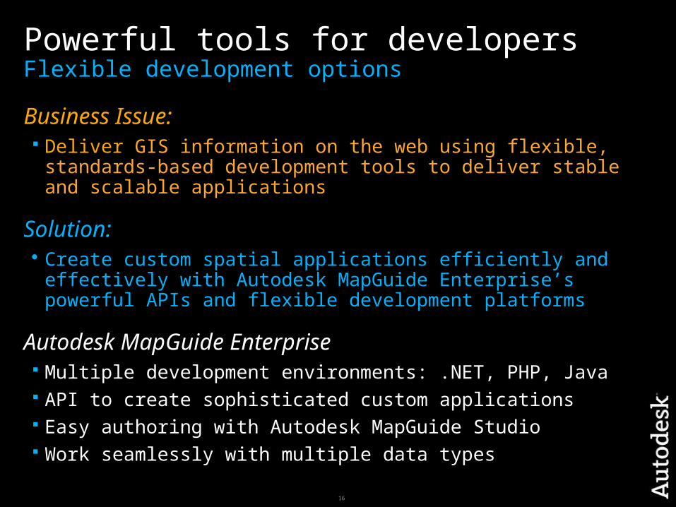
Powerful tools for developersFlexible development options
Business Issue: Deliver GIS information on the web using flexible, standards-based
development tools to deliver stable and scalable applications
Solution: Create custom spatial applications efficiently and effectively with
Autodesk MapGuide Enterprise’s powerful APIs and flexible development platforms
Autodesk MapGuide Enterprise Multiple development environments: .NET, PHP, Java API to create sophisticated custom applications Easy authoring with Autodesk MapGuide Studio Work seamlessly with multiple data types

17
Parcel data fromOracle ® databases
Kennedy
Ford
Truman
Roosevelt
Wilson
Washington
AdamsJones Smith
Yale Cornell
Fraiser
ZoeVarney
Armey Baker Diego Harvard
Merrit
Miller
Regan
Clinton
Eisenhower
Dartmouth
Bradshaw
Lang
Jackson Jefferson
Carter
Franklin
VanBuren
Warren
Lincoln
Jetson
Campbell`
Runner
Pear GrapeOrange
Plum
Beet
Carrot
Tomato
Peach
Banana
Apple
Berry
FDO Geospatial Data Access
Utility data froman SDF file
Property Data from a MS SQL
Server™
Zoning dataESRI® ArcSDE®
Aerial photos
Natively access data from multiple
spatial sources
Avoid conversiondata lossdata copiesstale data

18
Easy website administrationFast, scalable, affordable
Business Issue: Deploy and sustain web mapping applications with minimal effort and
specialist knowledge in GIS
Solution: An easy to install web mapping system that’s fast, scalable, secure,
and affordable
Autodesk MapGuide Enterprise Bundled Apache web server, PHP, and Java® components Integrated installers for either Microsoft® Windows® or Linux®
platforms Preconfigured application makes it easy to get up and going

19
Access to open source innovationInteroperability, standards, open systems
Business Issue: Customers are demanding more innovative and cost-effective web
mapping solutions
Solution: Deploy applications on either MapGuide Open Source or Autodesk
MapGuide Enterprise assured version
Autodesk MapGuide Enterprise Innovations drawn from MapGuide Open Source community Additional FDO providers from open source Support for open standards such as WMS/WFS

20
How does open source fit?Autodesk MapGuide Enterprise vs. MapGuide Open Source
CODEBASE
ParticipationContributionExploration
“Of developers,for developers.”
Open Source
Enterprise
TestedProduct SupportPriority on Issues
“Integral part of the Autodesk geospatial
platform.”
DEVELOP
DEPLOY“End users manage own risk.”“Supported by Autodesk.”
Low barrier to entry.Maximum flexibility for
developers.
Consistency.Affordability.
Minimal business risk.

21
How does open source fit?Autodesk MapGuide Enterprise vs. MapGuide Open Source
CODEBASE
Open Source
Enterprise
Autodesk MapGuide Enterprise
Affordable.
Supported.
Minimize business risk.
MapGuide Open Source
Low barrier to entry.
Maximum flexibility for developers.
End users own the risk.
22
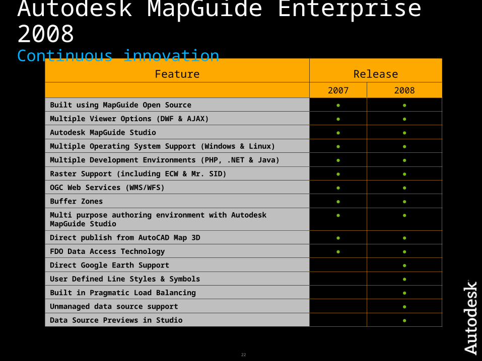
Feature Release
2007 2008
Built using MapGuide Open Source ● ●
Multiple Viewer Options (DWF & AJAX) ● ●
Autodesk MapGuide Studio ● ●
Multiple Operating System Support (Windows & Linux) ● ●
Multiple Development Environments (PHP, .NET & Java) ● ●
Raster Support (including ECW & Mr. SID) ● ●
OGC Web Services (WMS/WFS) ● ●
Buffer Zones ● ●
Multi purpose authoring environment with Autodesk MapGuide Studio ● ●
Direct publish from AutoCAD Map 3D ● ●
FDO Data Access Technology ● ●
Direct Google Earth Support ●
User Defined Line Styles & Symbols ●
Built in Pragmatic Load Balancing ●
Unmanaged data source support ●
Data Source Previews in Studio ●
Autodesk MapGuide Enterprise 2008Continuous innovation

23
The Value of Autodesk MapGuide EnterpriseInformation anytime, anywhere
Quick information sharing via the web
Powerful and flexible development options
Easy to install, configure, and sustain
Leverages open systems