urban planning process in curitiba - niiat.ru planning process in curitiba... · (jorge wilheim)....
TRANSCRIPT

Luisiana Paganelli Silva
Daniele Coutinho Moraes
Sheyla Maria Lagos Santos
External Affairs Advisory
Urban Planning Process in Curitiba

CURITIBA
SÃO PAULO
SANTA CATARINA
(NUC = central urban nucleus)
CURITIBA
Population:
1.746.896 hab. (Census 2010)
Growth in population:
2000-2010: 0,96% (per year)
RMC (29 municipalities)
Population:
3.223.836 hab. (Census 2010)
Growth in population:
With Curitiba
2000-2010: 1,36% (per year)
Without Curitiba
2000-2010: 1,87% (per year)
NUC

1943
AGACHE PLAN
First Master Plan – Radial Structure
Radial and Perimetral Development
population: 127.000 inhab.
DOWNTOWN
Urban Planning Process in Curitiba

Agache Plan in Curitiba´s map
Plan developed by the company Coimbra
Bueno & Cia. Ltda., from Rio de Janeiro,
executed by the french arquitect Alfred
Agache.
The criteria adopted for the development
of the city´s master plan were based on
the creation of areas with special functions,
called functional centers. Ex: housing,
services, industries, and a road network
restructuring.

1965 – 66
Master Plan (Serete Plan) → public contest organized by the
Municipality to continue the urban planning process in the city
(Jorge Wilheim).
Linear Structure – Axis – Linear Growth
population: 500.000 inhab. N
O E
S
DOWNTOWN
Urban Planning Process in Curitiba

Research, evaluate, plan and monitor the organization of the urban environment,
in its local and regional dimensions, through elaborating, coordinating and technically
improving programs, plans, projects and spatial systems for municipal information, as well as
executing the permanent operational and budgetary adjustment of the Master Plan and
Municipal Laws resulting from it, adjusting its tools for physical and territorial management to
the aspirations of the society regarding social, cultural and productive aspects, according to
constitutional principles of Urban Management and its legal guidelines, announced in the
City’s Act.
IPPUC Created in December 1st, 1965
Mission of IPPUC

STRUCTURAL
CORRIDOR
ZR 4 ZR 4
ZR 3
ZR 2
ZR 3
ZR 1 ZR 1 ZR 2
Urban Planning Process in Curitiba
LAND USE
TRANSIT ROAD NETWORK
ENVIRONMENT

“Trinary” System
Rapid avenues, one-way
Exclusive lanes for buses

Structural Axis

2004
Master Plan Revision → City’s Act - Consolidação e metropolização
pop.: 1,7 million
→ Maintained the guidelines established by the 1966 Master Plan
→ Consolidated important urban policies for the city
→ Implemented new urban tools
→ Promoted public participation in the elaboration of
complementary plans – democratic management
DOWNTOWN
N
O L DOWNTOWN
S
LINEAR GROWTH
Structural Corridors
Urban Planning Process in Curitiba

Urban Planning Tools Building Incentives – Heritage Building

Building Incentives – SOLO CRIADO – 1991 - Affordable Housing
Urban Planning Tools

Building Incentives – Green Areas
Urban Planning Tools

Planos Setoriais
Methodology
→ Diagnosis, evaluation and discussion with the community
→ Proposals for public hearings – available online
Sectorial planning
I – Municipal Plan for Urban Mobility and Transportation;
II – Municipal Plan for Affordable Housing;
III – Municipal Plan for Economic Development;
IV – Municipal Plan for Social Development;
V – Municipal Plan for Public and Social Defense;
VI – Municipal Plan for Environmental Control and Sustainable Development.

New corridor of
development
18km total length
23 affected neighborhoods (287.000
inhabitants)
→ 21.000 m² of green areas
→ 5.200 planted trees (22 native species)
→ 18 km of bikeways (6km phase 1)
Mobility and Transport Network GREEN LINE

Green Line

GREEN LINE
Mal. Floriano
SOUTH AXIS
NORTH AXIS
BARIGUI PARK
WEST AXIS
CIC
Centro
São Paulo
Future preview – 20 years

Integrated Transport Network- RIT
Mobility and Transport Network
Accessible network: 500m
Single fare
82 km of dedicated lanes
13 municipalities
2.270 buses
355 lines
20.850 trips/day
2.380.000 passengers/day
30 terminals
347 tube stations
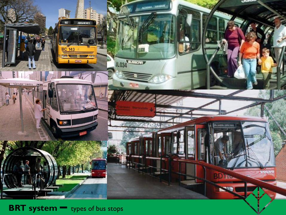
BRT system – types of bus stops

120 Km - Interparks
Bikeways

Citizenship Streets - Integration between services and transport Regional Administration Division – “Citizenship Streets”
Integration between Transportation and Services

Recommended by the 1966 Master Plan
3 days intervention
Objection from area merchants
6 blocks (nowadays 15)
Pavement, lighting, planters and furniture
Street closure:
Rua XV de Novembro turned into a pedestrian street in 1972

Stadium
Commercial Hospitality
and Press
Affiliated
Business
Terrace and
Food Court
FIFA WorldCup 2014