urban planning problems in nigeria: a case of onitsha
TRANSCRIPT

SINGAPOREAN JOuRNAl Of buSINESS EcONOmIcS, ANd mANAGEmENt StudIES VOl.1, NO.12, 2013
41
41
URBAN PLANNING PROBLEMS IN NIGERIA: A CASE OF ONITSHA METOPOLIS OF ANAMBRA STATE
Izueke Edwin Madu .C.
Eme Okechukwu Innocent 1,2Department of Public Administration and Local Government Studies
University of Nigeria, Nsukka
Abstract Over the last thirty years many urban areas in Nigeria have experienced dramatic growth as a result of rapid urbanization and population growth. While cities in Nigeria as well as other parts of the world, command a dominant role as both centres of production and consumption, rapid urban growth of Nigerian cities has seriously outstripped the capacity of most cities to provide adequate basic services to their citizens. This study investigates the factors that led to the rapid urbanization of Nigerian cities, especially Onitsha metropolis; the constraints to effective provision of urban amenities; and the causes of poor urban planning. The findings showed that the presence of substantial social infrastructure in Onitsha urban area has been the major factor that engendered its urbanization. It also revealed that there is rapid urbanization in relation to effective plans to provide adequate urban infrastructures/amenities to service this trend. Furthermore, there is a strong correlation between lack of good population projection, inaccurate census data and poor urban planning in Onitsha. Hence, these engenderers the bad effects of urbanization. The study calls for a revision of the existing planning practice to take into account the growth in the urban area, and the consequent increase in the demand for urban infrastructural services. It gave suggestions on ways to improve urban planning in Nigerian cities to include; proper articulation and implementation of planning policies and programmes to address future influx of people in Onitsha urban area; urban renewal and slum clearance programmes; imposition of a moratorium on residential developments in urban areas and most importantly, governments’ commitment to tackle the multifarious problems of urbanization and urban planning our urban areas. Keywords: Urban Planning, Urbanization, Infrastructure Decay, Migration & Population Growth.
Introduction Urban centres throughout the world exhibit an incredible diversity of characteristics, economic
structure, levels of infrastructure, historical origins, patterns of growth and degree of formal planning. Yet, many of the problems they face are strikingly familiar. But in developing countries, particularly in Africa, urban residents suffer to a great extent from severe environmental and health challenges associated will insufficient access to clean drinking water, inadequate sewage facilities and solid waste disposal (United Nations 2003).

SINGAPOREAN JOuRNAl Of buSINESS EcONOmIcS, ANd mANAGEmENt StudIES VOl.1, NO.12, 2013
42
42
The situation is even worse in countries of sub-Saharan Africa, especially in Nigeria (Onibokun 1989:3). One of the most visible and disturbing characteristics of the urban areas in Nigeria is the decline of their infrastructural base. Onibokun (1989:7) elucidates this point further by saying that “as urban populations grow, and as available resources decline, public infrastructure is being degraded to the point where cities are seriously losing their capacity to operate as productive entities”. In support of this claim, Stern (1991:7) pointed out that
“Solid wastes are uncollected and piles of decaying wastes are
allowed to rot in the streets; schools are over-crowded; urban roads have deteriorated into quagmires in rainy seasons; …. Public telephone…. is an impossible dream; public transport systems are becoming severely over loaded; and more and more people are obliged to live in unserviced plots… Not only is little new infrastructures constructed, but existing infrastructures are poorly maintained”
Poor urban planning in the face of Rapid urbanization is therefore regarded as one of the major
problems confronting many urban areas in Nigeria with special reference to Onitsha Urban area. The filth and infrastructural degradation that have over taken Onitsha is as a result of poor urban planning. The failure of land sub-division and servicing programmes to keep pace with rapid urban growth has led to wide spread illegal and informal developments, hence the growth of squatter settlements or slum areas, for instance, the housing clusters at Okpoko, Fegge, Woliwo, Odoapku. Etc. According to Elekwa (1991), many development projects carried out in these areas were without regard to the environment and this poses potential health problems and other hazards such as flooding, congestion, confusion etc. This has hindered the extension of not only of water, electricity and solid waste collection services, but also adequate sanitation arrangements and road networks to such areas.
Related to the deficiencies in infrastructure provision and waste management, environmental problems in Onitsha also arise from the inability of public sector authorities like the Onitsha Town Planning Authority and the Onitsha Local Government councils to enforce regulations governing land development, industrial emissions etc. Onibokun (1999:7) adduced reasons for their inability to include; “poor critical assumption in population projections which have often been extremely weak, and the inability of plans to be adjusted and/or refined in the light of changing conditions, such as the invasion and setting up of unused public spaces among other land uses”. In line with these daunting problems facing urban planning in the face of rapid urban growth and urbanization, Conceptualizing Urban Planning Land use for residential, commercial, industrial and other purposes has become of great concern as it is usually the focus of urban research. This has been confirmed through the works of many urban researchers like Burgess and McKenzie (1925) on American cities, particularly Chicago; Mabogunje (1968) on Lagos: Ayeni (1968) on Jos; Frishman (1977) on Kano; Olaore (1981) on Kaduna; Okpala (1981) on Enugu and Onitsha. Most of those studies show that urban areas are of enormous political, social, economic and cultural importance in numerous places in which they are located.

SINGAPOREAN JOuRNAl Of buSINESS EcONOmIcS, ANd mANAGEmENt StudIES VOl.1, NO.12, 2013
43
43
Urban planning as the name implies can be very broad or very narrow, comprehensive in focus, system oriented or problem oriented. However, the essential feature that distinguishes urban planning from other types of planning is its concern for geographical space in the urban environment. According to Hall (1974:7), urban planning refers to planning with a spatial or geographical component in which the general objective is to provide for the spatial structure of activities or of land use which in some way is better than the pattern existing without planning.
However, this view of urban planning is not without critics. Indeed, Hall (1974) envisaged human geography as the basic discipline of urban and regional planning, while other conceive of geographical space (or land use) as too limited a concept to provide a proper comprehension of spatial planning. As Chadwick (1971: 79) has argued that:
the physical construction heritage of the planning profession has resulted in an overwhelming concentration upon ‘containers’, rather than upon the processes which involve and use such physically adopted spaces, and a reorientation, planners well have to use increasingly, the tools of mathematics, of information services, and of social sciences in general.
Urban planning, by whatever discipline it may be given, is an emerging paradigm, and provide a broader view of relationships between the use of space and the consequences of using it is a particular fashion. It is an important administrative action aimed at sustaining and improving the aesthetic nature of a town (Amujiri 2001: 404).
On this background, urban planning as used here refers to making choices among alternative as it regards the ordering and use of land and sitting of buildings and communication routes so as to secure the maximum practicable degree of economy, convenience and beauty. Theoretical Framework of Analysis
To explain how and how much the urbanization of cities inter-depend on urban planning requires integration of insights from the natural, engineering, social and health sciences as well as an active dialog between the scientists and policy makers (Ruth 2006:17). The system theory is therefore used to make the necessary connection. The system approach was first developed in the biological and engineering sciences before it was adopted by social scientists in explaining social and organizational phenomena. The major concepts involved in the system model can be summarized thus;
(a) A system can be perceived as a whole, with its parts in inter- dependent relationship. (b) A system has its boundaries and can be viewed in terms of its relationship with other
systems. (c) System have subsystems, and are a part of a supra system. (d) A system can be regarded as either open or closed. In this case, cities or urban areas are seen
as open systems, interacting with other systems. The system theory is both relevant and appropriate to the study of sustainable urban planning
and infrastructure, because it provides a flexible framework; one responsive to the issues of scale, and changing social and environmental conditions precipitated by the urbanization of urban areas overtime.
The system theory sees urban areas as emergent phenomena embedded within a spatial and historical context of interacting processes. It sees urban areas (cities) as complex evolving social

SINGAPOREAN JOuRNAl Of buSINESS EcONOmIcS, ANd mANAGEmENt StudIES VOl.1, NO.12, 2013
44
44
systems that react and interact in unexpectedly complex ways to seemingly simple changes. Based on this, the urban area is seen as an on-going, ever-changing, primarily social system, comprising human activities and their inter-relationships with the flows of people, materials, and energy.
The theory highlights the interdependence of the ultimate physical limits placed on urban services and infrastructure and the rate of urban growth. This approach naturally lends itself to defining hierarchical systems, which are characterized by urban elements interacting horizontally with each other and vertically with larger organizing structures. In other words, urban areas can be characterised as open systems that inter-depend on the rural areas, or be more influenced by a larger network of other urban areas (Kay et al 1999:721, 1994:32; Ausubel 1988: 3).
The urban systems are self-organizing and can be thought of in terms of resilience (adaptability) and transformability (ability to fundamentally change state). As recipients of inflows, in terms of increased population and infrastructural developments, the urban area as a complex adaptive system naturally goes through phases of organization – explosion/growth, conservation, release and reorganization (Kay et al 1999:723) Application of the Theory Applying this theory to the study at hand, it helps to explain the forces that drive urban infrastructural development. In this approach, urban planning and infrastructure are linked to the spatial and usage patterns that impact human ecological processes. These processes influence more micro level phenomenon, such as human behaviour and activity which serves as feed back into landscape and social patterns in the urban area. Completing the loop, acknowledgement of change spurs policy development which acts as factors affecting further alterations of urban infrastructure. For example, the demand of water and other infrastructural services beyond the cities capacity, spurs sprawl development which affects the quality of water and other infrastructures. This results in policy changes affecting future distribution of infrastructural services and development patterns. Therefore planning decisions to extend urban services to meet the fast growing spread of development in the urban areas will precipitate demands on infrastructural facilities necessary to deliver and sustain it. The pictogram below captures the framework used in this paper. Figure 1: A System Approach to Urban Planning and Development.
Patterns: Land use Urban heat islands
Drivers: Population/ economic growth Infrastructure investment. Processes:
Economic markets Nutrients cycle
Effects/changes: -Human behavior -Policy decisions

SINGAPOREAN JOuRNAl Of buSINESS EcONOmIcS, ANd mANAGEmENt StudIES VOl.1, NO.12, 2013
45
45
Source: Alberti et al (2006) Brief Ethnographic Setting of Onitsha Metropolis
The history of Onitsha is still a subject of controversy. Onitsha was said to be a 17th century village created by a group of migrants who moved away from a part of the disintegrating Benin empire, and in the course of this migration which took years, the Onitsha people settled at the eastern bank of the River Niger (Bosah 1973: 4).
The name Onitsha means dispersal it reflects the manner the emigrants dealt with obstacles placed on their routes by adjoining towns and villages. Meanwhile, as the March pushed towards the river Niger, some of the emigrants who grew wearing decided to discontinue the journey and seek permanent places of settlement since it was undertaken on foot. The migration from Benin was said to have taken place between 1504 and 1550 (Bosah 1973:2). However, there are two versions of the incident that led to the exodus of Onitsha people.
According to Bosah (1973:6), the first version was told of how Esigie, the mother of the Oba of Benin, on a certain day wandered into the farmland of Onitsha people in search of fire wood. The farmers took objection to what they considered a trespass and therefore beat her mercilessly. When the woman returned home, she reported the incident to the Oba, who became infuriated and ordered his warriors to punish and drive the farmers away, so the exit of Onitsha people from Benin was precipitated.
The second version was based on the death of a great chief whose position was hereditary. During his funeral, a quarrel ensured between two factions of the family as to which of them would bury the chief and by custom, inherit is title. However, the matter reached a point where arbitrators, on the advice of the Oba, placed two coffins side by side; each purported to contain the corpse of the late chief. One of the coffins was carved and highly decorated, while the other was plain and unattractive. The stronger faction hastily carried away the decorated coffin for burial, only to be dismayed at the graveside, to find that it contained a log of wood. But before their discovery, their rivals had carried away the second coffin and to their amazement and joy found the remains of the deceased chief in it. They hurriedly buried him and inherited the chieftaincy title.
However, the disappointed side refused to accept the verdict and therefore left their fatherland for good after a fight, in search of a new settlement. The exodus involved ten villages. Their leader was a powerful man called Chima. There were many legends of the people’s movement, but the basic cause of migration held by the indigenes was the clash between Chima and the Oba Esigie of Benin. After the departure from Benin, the emigrants travelled eastwards to the bank of the river Niger. Their first place of call was Ozara Agogoro were they rested for some days. Latter they went to Agbor in Ika land. From Agbor, the group moved to Obior before setting at the permanent which is today known as Onitsha. Contrary to this view is the ethnographic studies made by Onwujiogu (1981). He argued against the Benin origin of Onitsha people, but pointed to the fact that Onitsha is a true Igbo settlement with much earlier origin than 1030 A.D., and is one of the vast groups of Igbo settlements both east and west of the Niger that came under Nri theocratic hegemony in the hey days of Nri’s civilization. According to him, in the seventieth century, several Igbo settlements west and along the Niger including Onitsha were brought under Benin influence.

SINGAPOREAN JOuRNAl Of buSINESS EcONOmIcS, ANd mANAGEmENt StudIES VOl.1, NO.12, 2013
46
46
Geographical Location of Ontisha Onitsha is a city on the eastern side of the lower Niger basin about I km south of the confluence with the Anambra river in Anambra state. It is approximately between latitude 6°, 10 N and longitude 6°, 47E and measures about 150 miles north of river Niger (Henderson and Henderson 1962:15). The city and its environs belong to the equatorial rain forest belt of West Africa and receives more than 80 inch of rainfall annually, mostly during six months of the ruing season (Milne 1939: 773) According to Elekwa (1991:21) pointed out that the boundaries of Onitsha are drawn closely around the town itself, so that, if the town expands to north and east it will inevitably encroach into the territories of Anambra and Idemili local government areas (see fig 2)
Figure 2
Source: Adapted from the Onitsha Master Plan Geology/Topography of Onitsha The land scape of Onitsha is a low land (see fig 3). The eastern part of the town is a bit hilling while the rest is claimed by the river Niger which lies on the western part of the town. The inland town is on high grounds and more recently developed areas of Odoakpu and Otu are on lower grounds. Fegge and the unauthorized areas of Okpoko are situated within the flood plains (Elekwa 1991: 28).

SINGAPOREAN JOuRNAl Of buSINESS EcONOmIcS, ANd mANAGEmENt StudIES VOl.1, NO.12, 2013
47
47
However, the increasing urban activities and population explosion has resulted in widespread clearing of vegetation covering farmlands and wood lands throughout the area. Due to Onitsha's peculiar topography, erosion has become the greatest menace to the livelihood of this city's residents. Figure 3
Source: Adapted from the Onitsha Master Plan Population and Density of Onitsha Population data is necessary for planning. The future population growth constitutes essential background information for planners. If a plan for social and economic development is to have any chance of realistic implementation, it requires a parallel assessment of the dynamics of population growth. With a total population of 561000 (2006 census), it indicates that Onitsha has a very high overall gross density in excess of 187.2 persons per lecture. Commercial Activities in Onitsha Markets
i. Main market (Otu Nkwo) ii. Ose okwodu market iii. Ochanja Relief market iv. Niger bridge head market i. Main Market The Onitsha main market according to Nzekwu (1956: 65) has been acclaimed as the largest
open market in West Africa. The streets contiguous with the market sell the same range of commodities as well as high value technical consumer goods e.g. Radio sets, electrical appliances

SINGAPOREAN JOuRNAl Of buSINESS EcONOmIcS, ANd mANAGEmENt StudIES VOl.1, NO.12, 2013
48
48
etc. Further away from the market, the more bulky or specialized goods e.g. industrial goods and construction materials become more prevalent. These goods require a great deal of display space and here the pressure on land space is so high
The market is divided into zones, selling identical wares. The wholesale shopping district occupies an area bounded on the sides by Affar Street, Okwei road and Bida road. Hodder et al (1969: 240) contend that the over flow of the Main Market into streets began in the 1930’s, when a few shops opened in Bright street, but did not become significant unlit after the Nigerian civil war. Now, practically the ground floor of buildings in streets around the market district has been given over as shops and storage spaces. ii. Ose Okwodu Market It was formally a fire wood market converted to a Relief market to accommodate the traders at the main markets while construction of the main market was taking place. According to Mr Okeke the town planning officer, the wood dealers had to be moved from Ose Okwodu to the Nde nde wood market which still functions as a wood market till today. Ose Okwodu is situated at Niger Street, Fegge. The Relief market is regarded as a permanent market mainly for food stuff like yam, Garri beans etc. it is mainly a food market. However the Ose was too small and could not accommodate all the traders while the main market was under construction, so the Ochanja relief market was built. iii. Ochanja ‘Relief’ Market As a result of the inability of the Ose Okwodu market to accommodate the traders that were displaced during the reconstruction of the main market, the Anambra state government in 1984 acquired a piece of land at Okpoko and built the Ochanja relief market. The market was originally designed as a shopping complex but with the recent trading activities in that area, it has spilled into streets, covering Iweka road, Magaret Street and Modebe Avenue v. Niger Bridge Head Market This was built by the defunct Onitsha market authority in 1976, after the civil war. The market was for the sale of building materials like rods, woods etc. it was sited there so as to stop hawkers and traders form selling wood and building materials all over the town. Apart from rods, woods, there are also dealers in plumbing materials and patent (drug) medicine dealers. There are other smaller markets in the inland town controlled by land-owning families, where traders pay their rents and dues to these owners. Markets in Onitsha have spilled all over the streets such that you have residential building serving dual purpose of residential/commercial (shopping) centres. Existing Land uses in Onitsha The existing land uses in Onitsha has to a very large extent determined the location of recent commercial as well as industrial activities in the urban area (see fig 4). According to Nzekwu (1956: 6), the city of Onitsha which is home to the largest open markets and commercial centres in west Africa has attracted the establishment of large and small scale industries such as the premier breweries, lever brothers (now Unilever), Textile mills, Limca bottling company, Vita foam and many other private business enterprise. Also evident are the shops which litter the landscape with no controlled development and regulation. Industrial activities are traffic generating, and where there are no street or off street parking facilities, the result are traffic congestions and overcrowding of streets which are made

SINGAPOREAN JOuRNAl Of buSINESS EcONOmIcS, ANd mANAGEmENt StudIES VOl.1, NO.12, 2013
49
49
worse by the innumerable pedestrians, cyclist, taxi cabs, buses and mostly big trucks for transporting bulking materials to and from the industries and markets.
Figure 4
Source: Adapted from the Onitsha Master Plan Site Layout and Development in Onitsha Site planning is described as the art of arranging the external physical environment to support human behaviour (Lynch 1975). According to Ratcliffe (1981: 264) site plans locate structures and activities in three dimensional spaces and when appropriate in time. The preparation or consideration of a site plan will often relate to a detailed design for specific use, and the form of its layout will be governed by relevant provisions for development; the general accessibility and location of the area, the requirement of the topographical characteristic of the site (Elekwa 1991: 3) A critical look at the Onitsha planning framework reveals that there is a comprehensive plan in which the land uses are fairly well defined (see fig 6). The commercial heart is located in Otu around the main market, in the triangle between the Niger River, old market, road and new market road (see fig 7). This busy commercial area is surrounded by the high density residential area of American quarters, Oduakpu and Fegge. Most large scale and new industrial development is concentrated around the Niger bridge-head market, and more accessible new roads between Niger Bridge, Iweka round about and Owerri
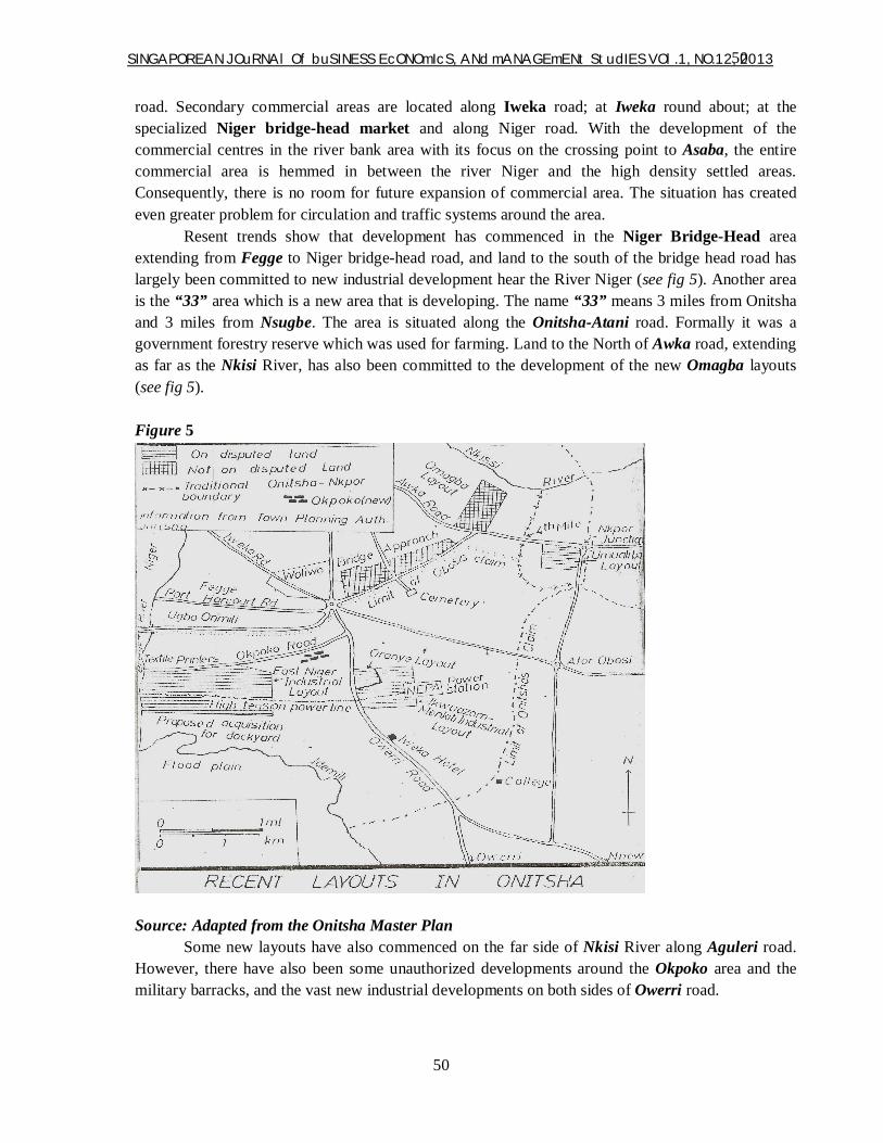
SINGAPOREAN JOuRNAl Of buSINESS EcONOmIcS, ANd mANAGEmENt StudIES VOl.1, NO.12, 2013
50
50
road. Secondary commercial areas are located along Iweka road; at Iweka round about; at the specialized Niger bridge-head market and along Niger road. With the development of the commercial centres in the river bank area with its focus on the crossing point to Asaba, the entire commercial area is hemmed in between the river Niger and the high density settled areas. Consequently, there is no room for future expansion of commercial area. The situation has created even greater problem for circulation and traffic systems around the area. Resent trends show that development has commenced in the Niger Bridge-Head area extending from Fegge to Niger bridge-head road, and land to the south of the bridge head road has largely been committed to new industrial development hear the River Niger (see fig 5). Another area is the “33” area which is a new area that is developing. The name “33” means 3 miles from Onitsha and 3 miles from Nsugbe. The area is situated along the Onitsha-Atani road. Formally it was a government forestry reserve which was used for farming. Land to the North of Awka road, extending as far as the Nkisi River, has also been committed to the development of the new Omagba layouts (see fig 5).
Figure 5
Source: Adapted from the Onitsha Master Plan
Some new layouts have also commenced on the far side of Nkisi River along Aguleri road. However, there have also been some unauthorized developments around the Okpoko area and the military barracks, and the vast new industrial developments on both sides of Owerri road.

SINGAPOREAN JOuRNAl Of buSINESS EcONOmIcS, ANd mANAGEmENt StudIES VOl.1, NO.12, 2013
51
51
Trends in Urban Growth and Urban Planning in Onitsha. The development of Onitsha owes much to her advantage of site and location (see fig 2). According to Ofomata (1975: 87), “Onitsha town is sited where a high ground is underlain by the sand stones of the Bende-Ameki formation, and comes very close to the River Niger providing a stretch of well drained healthy site in the flood plains of the River Niger.” Such favourable site at the meeting point of two contrasting regions (east and west of the Niger), and the Niger itself, providing a link with the Savannah zone to the north and the forest and Delta region to the south, enabled Onitsha to develop as an important commercial centre. Dike (1956: 19) also noted that the importance of its commercial activities drew a lot of migrants from the surrounding rural areas to become full time traders in the town. This increased the population and fostered its importance as a regional market for the upland Igbos; people from Igala, Aro, Asaba, Awka, Hausa towns and neighbouring village around Onitsha who came to trade.
The political position is another factor which contributed immensely to its early growth. In 1905 Onitsha was adapted as the political headquarters of the central division which was later reconstructed into Onitsha province. By 1911, Bedwell, the resident British administrator for Onitsha gave it, its first look as an urban settlement. In 1917, following the Township Ordinance, Onitsha was recognized as a second class township administered by a native authority (Hodder and Ukwu 1969:235). According to Milne, on the Intelligence report of the town of Onitsha, Onitsha became a town council around 1938 with the abolition of native administration. The broadening of the council was to enable the young and educated sections of the community, without creed, to take part in the administration of the area. This marked a period of more and more growth and development in the town of Onitsha. The British administrator coupled with the missionary activities helped enhance and foster early growth and development of Onitsha by providing schools and hospitals. The British government also provided pipe borne water, electricity and road networks. Figure 6
Source: Adapted from the Onitsha Master Plan

SINGAPOREAN JOuRNAl Of buSINESS EcONOmIcS, ANd mANAGEmENt StudIES VOl.1, NO.12, 2013
52
52
All these constituted “pull factors’ that acted as magnet attracting both rural and urban migrants who moved into the town in their hundreds. The 1931 census returned for Onitsha a population of 18, 084 with slightly more females (9257) than males (8, 827). By 1953, the population had risen to 76,921 with greater predominance of males (48,356) over females (28, 565), pointing to the rapid growth by immigration of male trader, male civil servants etc. (Hodder and Ukwu 1969:236)
Figure 7:
The Map of Onitsha
Source: Adapted from the Onitsha Master Plan With the increases in population, new settlement areas were mapped out; the Odoakpu extension by late 1950’s merged with the inland town as one contiguous settlement. Apart from the water side section, there was the Odoakpu layout, the inland town and the later extension of Fegge layout in 1955 all became high residential areas. The inland town having developed organically has little of the planned layout that characterized other residential areas. The government reserved areas (Ozala) developed into a low density residential zone, but with so many government offices adjoining or attached to the residential house, it seemed more of an area of mixed offices and residential uses.

SINGAPOREAN JOuRNAl Of buSINESS EcONOmIcS, ANd mANAGEmENt StudIES VOl.1, NO.12, 2013
53
53
As Onitsha started to engulf neighbouring villages of Nkpor, Nsugbe and Obosi, the Anambra state government then commissioned the Onitsha master plain in 1978 to check the physical development of the town (see fig 5). Originally the plan was designed to last for twenty years and has provisions for infrastructure based on the projected population of the town. The master plan of 1978 has hardly been subjected to modifications based on the trends of growth in terms of population and industrialization especially small scale industries. For instance certain areas are not zoned for residential or for industrial projects, but if the master plan is being modified it will meet and accommodate the needs of both industrial and residential purposes. Problems of Urban Planning in Nigeria: The Onitsha Experience
Despite the effort of successive administrations in Nigeria in ensuring qualitative developmental control through urban planning, the problems of urban planning is still a fact of life in many urban areas in Nigeria today (Amujiri 2001: 406). In specific terms, the problems of urban planning in Nigeria and Onitsha in particular can be examined as follows: Patterns of Settlement
According to UN Habitat report (1976:22); in Nigeria, little attention is been paid to sectoral and financial planning with the total neglect of physical planning. This has led to disorderly spatial and environmental development. The result in the words of Okeagu (1996: 39) is an outmoded urban structure providing little satisfaction from the point of view of efficiency and aesthetics. This pattern of unplanned or uncontrolled urban growth and settlement pattern has created a special brand of problem in almost every urban area in Nigeria, especially Onitsha. Lack of Involvement of Operational Agencies
In Nigeria, while developing urban plans, master plans, commercial and residential layouts and the likes, operational agencies have not been fully involved. Successive administrations in Nigeria have been hiring consultants to develop plans. Green (1981:30) stated that this has been done in Lagos, Kano, Kaduna, Jos, Onitsha, Enugu, Maiduguri, Port-Harcourt and many other cities in Nigeria. Green (1981:31) further noted that co-ordination is not a static abstract activity, but rather a process of dynamic adaptation to changing circumstances. The use of consultants and non-involvement of operational agencies poses serious problems to urban planning in Nigeria. Inadequate Qualified Manpower
Another major problem of urban planning is the inadequate qualified manpower to face the large planning and management responsibility; confronting it. Urban planning activities need a well qualified architect, surveyor, building inspector, drawing technicians, land valuation officers, site officers and a host of field officers. All these are lacking in most urban areas.
Political Interference Urban planning in Nigeria usually encounters service problems as a result of political
interference. This has resulted in politically motivated urban plans, layouts, buildings plans and construction of houses on unplanned locations. This has equally led to the distortion of master plans of some cities, illegal conversion of government reserved areas to commercial or industrial areas which constitute security risks and adversely affect urban planning.
Problems of Housing and Living Conditions Undoubtedly, poor housing conditions prevail in the majority of urban areas in Nigeria
especially in Onitsha. Despite all efforts, acute shortage of suitable and decent accommodation especially among the low income groups in urban areas like Onitsha. This has posed a serious to

SINGAPOREAN JOuRNAl Of buSINESS EcONOmIcS, ANd mANAGEmENt StudIES VOl.1, NO.12, 2013
54
54
urban planning. Surveys of housing conditions have indicated qualitative and quantitative deficiencies in residential accommodation in major towns and cities in Nigeria. Issues of Management and Institutional Framework
Most of the problems of urbanization in Nigeria according to Sada (1981:51) arise because of a certain dogged reluctance on the part of government to confront the fact that for Africa at least, ours is a highly urbanized country. There is no where the government has formally defined what an urban centre is and what are the powers, responsibilities and privileges of such community (Amujiri 2001:412). This question of legal status of an urban centre is critical as it affects the importance attached to their management.
According to Bali (1997), urban planning must be based on facts that can be collected and made known, and this collection and assembling of information represent the first stage in the development of a comprehensive or master plan. To Meyerson (1961), the comprehensive plan includes principal sources of the planning data from the community or area, and should provide such information as general population, school population, existing land uses patterns, tax rates, bounded indebtedness, capacity of utilities, subdivision regulations, housing and parks. The comprehensive plan is not a set of mandatory hard and fast rules and regulations. It should be flexible, and should be changed in the light of new conditions and new developments.
However, the comprehensive plan should cover such areas as land use, transportation, housing, conservation and safety.
Land use: The land use aspect of the comprehensive plan shows the purposed general distribution, location and use of land for housing, business, industry, open spaces, education, public buildings and grounds, solid and liquid waste disposal facilities and other categories of public and private uses (Griselle 1973).
Transportation: The transportation aspects show the location and extent of roads, high ways other systems and facilities for moving people and goods.
Housing: The housing aspect of the plan show the programmes and methods of improving housing and the provision of adequate housing sites to meet the needs of all economic segments of the community or area.
Conservation: The conservation aspect of the plan deals with the extent and means of achieving the conservation, preservation, development and use of natural resources. Open spaces/recreation, provision of open spaces for resources conservation and protection, outdoor recreation, public health and safety and agriculture.
Safety: The safety aspect of the plan deals with the programmes for protection from noise, flood, fire as well as other natural or artificial hazards to public health and safety (Meyerson 1961: 69).
The adoption of a master plan by a city or metropolis does not automatically control land uses. This is because the plan itself has no legal effect: it is commonly implemented by a variety of land sue controls. According to Blair (1971), the legal means of such controls are the town and country planning land, building codes, zoning and sub-division regulations.
Building Codes: These are a legislative set of principles for administrative guidance in regulating original construction and improvements. The code provides for minimum standards of building construction and conditions, and for human occupancy, and concerns such factors as lightening, ventilation, heating, sanitation plumbing, electrical work, types of building materials and

SINGAPOREAN JOuRNAl Of buSINESS EcONOmIcS, ANd mANAGEmENt StudIES VOl.1, NO.12, 2013
55
55
fire prevention and protection (Webster 1958). Building codes also cover a variety of commercial business such as bakeries, barber shop, drug stores, hospitals and hotels (Blair 1971).
Zoning: According to Goodman (1968), zoning is a form of governmental regulations providing for the orderly social and economic development of an area. This tool is most frequently employed to regulate the use of land and buildings by restricting certain areas for industrial, business, residential, agricultural and other purposes.
Sub-division regulations: The sub-division regulation is a statement of policy and standards which govern the sub-dividing or cutting up of large parcels of land into smaller parcels. It sets forth the community’s policies regarding the needs for public facilities, pavement widths, and development standards, for control and facilities (Lynch 1975). The increasing rate of urbanization has produced the need for urban and regional planners in Nigeria to develop policies which can control and manage urbanization (Tylor 2000). Because of the growth of the city, the practice of planning and managing cities in Nigeria has become progressively more demanding in terms of resources, organization and skill (Onibukun 1989: 49). Although the number and size of agencies responsible for generating polices and exerting powers in Nigerian cities have grown over the years, there has not been a corresponding improvement in the quality and quantity of urban services rendered Fourchard 2002:4). Recommendations There should be a critical review of plausible strategies for prevention of urban planning and development problems. This can be attained by proper urban administration and management of urban land and functional land uses by the Town Planning Authorities. It would also include the provision of an efficient institutional framework that would manage the energy input and waste output and public education of urban residents on the advantages of safe and healthy environment. A population-environment National Policy should be put in place to check the wave of rural-urban migration, while planning for future developments in urban centres should be guided by terrain analysis which must accommodate probable maximum growth and expansion of urban centres. Government must show, in no unmistakable terms, the willingness and commitment to fight urban environmental problems as a prime remedial measure. An analysis of the problem indicates the failure of governmental institutions to adapt to social and economic changes, and deficiencies in governmental actions accounts for sustained deterioration of urban environment. According to Satterwaite (1998: 150-177), the areas where government failures are most pronounced include among others waste management, pollution control, promotion of health and safety standards, provision for housing development etc. The Government is therefore called upon to initiate through her numerous agencies pro-active measures to remedy the situations. Existing National Polices on the environment should be implemented to the letter in order to effectively manage solid waste and industrial pollution. Enforcement of Urban Land Use policies, Housing Policies and Planning Policies are advocated in all urban centres in Nigeria in order to establish harmony and discourage dysfunctional land use patterns. Part of this implementation will include urban renewal action and slum clearance (Okoye, 1979- 84). One of the effects of uncontrollable growth is an overburdening of utilities, facilities and other public services. In response to such problems, the city can place a moratorium on further development until planning is completed; regulations are adopted and public facilities are expanded.

SINGAPOREAN JOuRNAl Of buSINESS EcONOmIcS, ANd mANAGEmENt StudIES VOl.1, NO.12, 2013
56
56
For example, a city ordinance could simply declare that no more building permits for residential construction would be issued until certain standards for the provision of public services are met. In such cases, permits are granted only if the land owner can show the availability of adequate public service such as electricity, water, drainage, roads etc. Finally, the various organs of government, non-governmental organizations and public and private stakeholders must work harmoniously through a coordinating agency for effective management of environmental problems in our urban centres. Put differently the Habitat agenda acknowledges the important roles which the private sector, non-governmental organizations and communities play in the shaping of the city. It recommends governments to work in partnership with these actors to improve urban conditions. It states that within the public sector, that the local government is the most suitable level to establish partnership with these urban actors and therefore needs to be strengthened. Conclusion
The rapid growth of urban centres in underdeveloped or developing countries has brought to the fore, various problems which are manifest not only in the physical forms of the city, but also in the ways they function. Most of our cities have grown in an unmonitored and uncontrolled manner, which has led to the manifestation of various problems such as over-population, over-crowding, traffic congestion, environmental pollution, unemployment as well as the general deterioration of urban amenities, which have in turn precipitated various socio-economic, socio-cultural and sanitary problems in Nigerian cities. The awareness and need for a plan to manage the phenomenal growth and uneven development of Nigerian cities have become imperative.
In Onitsha Metropolis, the converging forces of urbanization population, technology and environment have come into serious conflict. This situation is a reflection of the poor urban planning efforts in the country. As reflected, very little attention to urban planning has result in an outmoded urban structure providing little satisfaction from the point of view of efficiency or aesthetics. Furthermore, the existing system of local government has failed to provide efficient urban administration. Common services like drainage and refuse disposal have continued to suffer serious neglect often given rise to the ugly sight and considerable health and environmental hazards in Onitsha metropolis.
Planning for specific projects are not coordinated and integrated to meet the demands of the fast-growing population now and in the future. And as well, they fail to indicate land use patterns, population distribution, location of industries, shopping facilities etc. High ways, sewers, water mains, schools parks, electricity etc are things that take a great deal of planning and most be related directly to the population density. By knowing the population holding capacity of given area, for instance, engineers can know for what capacity to build their water lines.
Nevertheless, shifting the emphasis of concern to the urbanization of Nigeria cities and particularly Onitsha urban area and the provision of adequate urban amenities through effective and efficient urban planning, we can begin to have better control over the adverse consequences of the rapid urbanization and develop planning strategies to institutionalize good urban governance.

SINGAPOREAN JOuRNAl Of buSINESS EcONOmIcS, ANd mANAGEmENt StudIES VOl.1, NO.12, 2013
57
57
Bibliography
Adeniyi E.O. (1982), ‘Administrative Framework for Physical Planning in Nigeria’in Sada and Oguntoyibo. Urbanization Processes and Problems in Nigeria. New York: McGraw Hills Publishers.
Amujiri, B.A. (2001), ‘Urban Planning in Nigeria; Problems and Remedies’. In Ezeani and Elekwa (eds). Issues in Urbanization and Urban Administration in Nigeria. Nsukka: Jamoe Enterprises.
Ayeni, B (1968), Concepts and Techniques in Urban Analysis. London; Groom Helm.
Blair, T.C. (1974), The International Urban Crisis. New York; Hill and Wang. Bosah, S.I. (1993), Groundwork of the History and Culture of Onitsha. Place and Publishers not
stated. Braimah, A.A. (1999), ‘Urban Planning and Development’ in Taylor R.W. (ed) Urban Development
in Nigeria. Alder hot: Avebury. Burgess, W. and Mckenzie, R. (1925), The city. Chicago: University of Chicago Press. Chadwick, G. (1971), A Systems view of Planning: Towards A Theory of the Urban and Regional
Planning Process. Oxford; Pergamon Press. Elekwa, N.N. (1999), The Management of People and their Environment. Nsukka; Falladu
Publishing Co. Elekwa, N.N. (2001), ‘The concept of Developing and Industrial Societies and Emerging Trends in
City Management’. In Ezeani and Elekwa (eds); Issues in urbanization and Urban administration in Nigeria. Enugu; Jamoe Enterprises.
Elekwa, N.N. (2004), An Introduction to the Study of Population Dynamics and Data Simulation for
Planning and Urban Development. Abakilike: Willy Rose. Ezeani, E.O and Elekwa, N.N. (2001), Issues in Urbanization and Urban Administration in Nigeria.
Enugu; Jamoe Enterprise. Griselle, S. (1973), General Plan Guidelines. California: Council of Inter-governmental relations. Hall, P. (1974), Urban and Refusal Planning. Penguine books place and Publishers not stated. Henderson, H.K and R.N Ukwu, (1962), An Outline of the History and culture of Onitsha. Ibadan;
Ibadan University Press.

SINGAPOREAN JOuRNAl Of buSINESS EcONOmIcS, ANd mANAGEmENt StudIES VOl.1, NO.12, 2013
58
58
Henderson, R.N. (1973), The King in Every Man: Evolutionary Trends in Onitsha Ibo society and Culture. New Haven and London: Yale University Press.
Hodder, B.W and Ukwu, L.U. (1969) Markets in West Africa: Studies of Markets and Trades among
the Yourba and Ibo. Ibadan; Ibadan University Press. Lynch, K. (1975) Site Planning (2nd ed). Cambridge Massachuset; the MIT Press. Mabogunje, A.L. (1968), Urbanization in Nigeria. London: University of London Press. Mabogunje, A.L (1978), Shelter Provision in Developing countries. Surrey; the Gresham Press. Onibukun, A.G. (1989), ‘Urban Growth and Urban Management’ In Nigeria, in Stern, R.E. and
White, R.R. Managing Rapid Urban Growth. London: Westview press. Stern, R.E. (1989), ‘The Administration of Urban Service’ in Stern, R.E. and White R.R. African
cities in crisis: Managing the Rapid Urban Growth. London: Westview press
Uzuegbunam, A.O (2005), Population and Development in Nigeria: Inter Relations. Enugu; magnet Business Enterprises.
JOURNALS and publications Azikiwe N. (1930), ‘Fragments of Onitsha History’. The Journal of Negro History. Vol. 15, No. 2.
Retrieved on 2007-12-24. Okoye, T.O. (1979) ‘Urban Planning In Nigeria And The Problem Of Slum’. Third world planning
review. Vol.1 No.1 Olaore, G.O. (1981) ‘Values Of Land And Rentage Of Shelter In Nigerian Cities’.A case study of
Kaduna. Ibadan: NISER monograph series. Satterthwaite, D. (1998), Health And Environmental Problems In Cities Of Developing Countries:
Population Distribution And Migration. New York: United Nations World Bank, (1995), Restoring Urban Nigeria: A Strategy for restoring urban infrastructure
& Services in Nigeria. Washington: World Bank. United Nations (UN) 1991, “World Urbanization Prospects 1990: estimates and projections
of urban and Rural populations and of urban agglomerations’. New York; UN (1991).

SINGAPOREAN JOuRNAl Of buSINESS EcONOmIcS, ANd mANAGEmENt StudIES VOl.1, NO.12, 2013
59
59
Government publication Milne, W.R.T (1939), ‘Intelligence Report On The Town Of Onitsha’ (National Achieves Enugu)
file noon Dist. 773. Vol.1 Minloc 16/1/2029
Onitsha master plan, 1978 Unpublished articles Elekwa, N.N. (1991) ‘Urban Development; Physical Planning And Environmental Consideration’: A Research Administered by the Social Science Association of Nigeria. Achike, P. (1989) Urbanization and Urban Growth: A case study of Onitsha Urban area. A research project presented to the Department of Sociology and Anthropology, University of Nigeria, Nsukka