urban physical development and master planning in zimbabwe
TRANSCRIPT
72
Urban physical development and master planning in Zimbabwe: An assessment of conformance in the
City of Mutare
Aaron Mabaso, Munyaradzi Davis Shekede, Innocent Chirisa, Lazarus Zanamwe, Isaiah Gwitira and Elmond Bandauko*
AbstractUrban master plans play a critical role in the environmental management of urban
landscapes in that they guide the physical developments that take place on and in them. In spite of this important role, there is limited knowledge on the degree to which their mapped objectives are achieved in actual terms. This gap in knowledge is mainly due to the lack of empirical methods for assessing plan implementation. In this stu dy, we assess the degree of conformance of physical developments in the city of Mutare to master plan land use proposals. To do this, we carried out a GIS-based overlay analysis of the master plan and the land-use outcomes. We used an error matrix and Kappa Coeffi cient to assess whether land use proposals conform to existing developments in the city. The results of this study are that there is high overall conformance, although some proposed land uses do not conform to the master plan. We conclude that the adoption of GIS-based methods of compliance monitoring of land-use activities within urban environments provides an objective, rapid and effi cient way of managing activities within such environments. We therefore recommend the adoption of such me thods in urban areas for early detection of non-conformance and sustainable management of urban areas.
*Aaron Mabaso holds an Honours’ Degree in Rural and Urban Planning and a Master’s Degree in Environmental Policy and Planning all from the University of Zimbabwe.
Bandauko Elmond is a Teaching Assistant in the Department of Rural and Urban Planning, University of Zimbabwe. He holds a BSc Honours Degree in Rural and Urban Planning from the same University. His research interests include housing studies, land contestation, urban systems analysis, urban policy and governance, African urban transformation. He has published 8 articles in referred academic journals.
Innocent Chirisa is a Senior Lecturer in the Department of Rural and Urban Planning at the University of Zimbabwe. A scholar of more than 70 refereed journal articles, achieved in a space of eight years, Chirisa holds DPhil degree in Urban and Regional Planning, an MSc and a BSc Honours in Planning. His areas of research interest are urban planning, urban policy and environmental and natural resources’ stewardship.
Isaiah Gwitira is is a lecturer in the Department of Geography and Environmental Science at the University of Zimbabwe. His research interests are Spatial Epidemiology, GIScience and Remote Sensing. He hold an MPhil degree and is pursuing studies in GeoTechnology.
Lazarus Zanamwe is a Senior Lecturer, Department of Geography and Environmental Science, University of Zimbabwe. He is a specialist in population and demographic studies. A holder of a PHD in Population Studies, Leeds University, UK, MA in Population Studies, Leeds University, UK, Graduate Certifi cate in Education, University of Zimbabwe, Zimbabwe, and a BA Honours Geography, University of Zimbabwe. Zanamwe is a seasoned scholar, researcher and academic.
Munyaradzi Davis Shekede, is a University of Zimbabwe lecturer in the Department of Geography and Environmental Science. He teaches Applications of Earth Observation and Geospatial Science to management of natural resources, Masters in Environmental Policy and Planning. Shekede is pursuing a DPhil in understanding effects of Global environmental changes on savanna ecosystem structure and function.(E-mail address: [email protected])
© 2015 University of Namibia, Journal for Studies in Humanities and Social SciencesVolume 4, Number 1 & 2, 2015 - ISSN 2026-7215
73
Urban physical development and master planning in Zimbabwe: An assessment of conformance in the City of Mutare
Introduction and backgroundAlthough several studies have been carried out on conformance of land use activities
to physical plans (Baer, 1997; Oliveira & Pinho, 2009; Chigara, et al., 2013), few studies have assessed the conformance of phy sical developments to land use proposals (Alter-man & Hill, 1978; Talen, 1996b; Brody & Highfi eld, 2005), despite the central role such assessment plays in regulating and managing physical urban development. In the absence of quantitative empirical assessment of plan implementation that links plan intentions to land-use outcomes, there is limited knowledge on the extent to which Master/Local Plans are guiding physical development in urban areas. In fact, most urban planning evaluation has focused more on planning practice, quality and nature of plans, with less attention paid to what master plans achieve in practice (Laurian, et al., 2004). This seems to be the case with urban planning in Zimbabwe, where most studies have focused on either evaluating piecemeal planning practice (Chigara, et al., 2013) or examining urban development control challenges that exist in Zimbabwean planning practice (Chipungu, 2011). This study therefore seeks to assess the conformance of physical developments to the urban master plan land-use proposals, using the City of Mutare as a case study. It attempts to provide an understanding of the degree to which the physical plan is implemented and its objectives are met.
The assessment of master plan implementation makes it possible to determine the extent to which land use activities conform to master plans. The fi ndings of this assessment may also be converted into knowledge (Alexander & Faludi, 1988). Such knowledge on the extent to which development plans are guiding physical developments in urban settings may make it easier to eff ect the necessary improvements on plan implementation and help to validate the importance of urban master plan production.
The study is also important in determining the relationship that exists between urban planning theory and practice, and the eff ectiveness of the existing planning system in controlling urban development. In theory, physical developments should conform to the master plan’s land use proposals and any non-conformance will represent a gap between planning theory and practice or an ineff ective planning system. In this study, we assess the degree of conformance of land-use activities of City of Mutare to the master plan within a Geographic Information System as a fi rst step towards understanding the sustainability of urban developments in Zimbabwe. In theory, the plan should infl uence development by guiding the physical outcomes on the urban landscape. Thus, this assessment determines whether and to what extent the predictions by urban planning obtain in practice.
Theoretical underpinnings and literature reviewThe broad objective of urban development and planning regulations is to ensure the
orderly development of urban areas. An urban development plan therefore sets the agenda for the development of the local authority’s area over its lifespan (Chigara, et al., 2013). Urban development plans seek to provide a suitable living environment for all by ensuring safety, amenity, accessibility, energy conservation and environmental protection. They also provide for orderly and progressive de velopment of land in urban areas, preserve amenities on that land and promote environmental control and socio-economic development (Ondiege & Okpala, 1999). Most cities in developing countries are confronted with a number of problems, including, but not limited to, the upsurge in slums, increased congestion and environmental pollution. These problems are usually indicators of non-implementation or inadequate implementation of physical plans, or a mismatch between actual master plans and land-use outcomes (Diaw, et al.,2002; Chigara, et al., 2013; Afrane & Adjei-Poku, 2013). This mismatch may be the result of normal variation in the planning and development process, or be indicative of problems in the planning process (Loh, 2011).

74
Urban physical development and master planning in Zimbabwe: An assessment of conformance in the City of Mutare
An empirical assessment of land-use outcomes against master plans is therefore critical, as it may provide data required for the development of sound management strategies, so as to ensure full implementation of urban master plans. The understanding and evaluation of urban master plan implementation also determines the plans’ eff ectiveness and success, allowing for the improvement of plans and the planning process (Oliveira & Pinho, 2009; Oliveira & Pinho, 2010).
There are two approaches to assessing the implementation of urban development plans, namely conformance and performance based evaluation (Loh, 2011). The selection of the approach to be used depends on one’s understanding of spatial planning. A conformance based evaluation focuses on assessing the linkages between plans and actual urban developments. In this case, implementation is considered a success if developments conform to plan proposals (Faludi, 2000; Laurian et al., 2004). The performance-based approach focuses on plan ning processes and considers the plan as an aid to future decisions-making processes rather than a blue print. A plan is considered to be implemented if development patterns adhere to its policies and meet its objectives, and plan implementation is considered to be a suc cess if the plan is consulted in decision-making processes (Faludi, 2000). The performance based approach focuses on whether and how the plan is consulted in subsequent planning process which corresponds to a detailed analysis of the decisions and actions of a number of actors who are supposed to receive the plan messages (Oliveira & Pinho, 2009; Oliveira & Pinho, 2010). As indicated earlier, a plan is considered implemented if it is used or consulted in decision-making processes, though not necessarily adhering strictly to the actual outcome. Departures from a plan may be also considered implemented if they are rational or inevitable (Alexander & Faludi, 1989; Faludi, 2000; Mastop, 1997; Mastop & Faludi, 1997).
The plan assessment approach is based on the assumptions about planning, its function, or purpose (Faludi, 2000). In this case, plans can be classifi ed as either project plans or strategic plans. Project plans involve a technical exercise which produces a document containing a set of prescriptions for action, a blueprint of the intended outcome and the measures needed for its realization (Faludi, 2000; Laurian et al., 2004). Strategic plans involve a learning exercise, which produces an indicative and fl exible plan document capable of guiding the planning process and evolving alongside with it (Faludi, 2000). Diff erent plan eva luation approaches make use of project and strategic plans. The conformance-based approach is suited to project plans, where implementation assessment must follow the logic of conformance of outcomes to plan intentions. The performance-based approach is suited to strategic plans, where there is need to establish whether or not the plan performs its function of guiding the decision-making process (Faludi, 2000).
Urban planning challenges in developing countries Developing countries are urbanising at an unprecedented pace (Roth, 2012 ). More
than 90 per cent of urban population growth in the next 30 years will occur in Asia, Africa and Latin America. Although urbanisation is increasing, there are several challenges for policymakers, particularly, as urban population growth and steadily rising incomes result in higher resource consumption. Cities in many developing countries have not been able to cope with the rapidly surging demand for housing, physical infrastructure (including roads and telecommunication tech nologies), and social services such as health and education to address the needs of growing populations (Cohen, 2004). In 2010, for the fi rst time ever, more than half the global population was living in urban areas. In keeping with this trend, it is estimated that by 2050, urban areas will be home to more than two thirds of humanity. This fast pace of urbanisation, mainly in developing countries, is creating cross-secto ral challenges for urban governance that need to be addressed, using integrated,
75
Urban physical development and master planning in Zimbabwe: An assessment of conformance in the City of Mutare
multi-stakeholder mechanisms. The key challenges are urban sprawl, lack of infrastructure, depletion of resources, environmental deterioration and the risk of natural disasters. The following paragraphs are going to provide detail on some of the major urban planning challenges facing developing countries and explain how GIS and remote sensing can provide solutions to some of them.
In most developing countries such as Zimbabwe, master and local plans are the two main planning instruments used to guide urban development. In this study, we sought to assess how urban development conforms to what is laid down in these master pans, using the City of Mutare as a case study. It is important for planners to evaluate what happens to plans after they are adopted, identifying factors likely to lead to higher levels of implementation and eff ectiveness (Alexander & Faludi, 1989; Talen, 1996b; Baer, 1997; Laurian et al., 2004; Brody & Highfi eld, 2005). In most cases, a development plan precedes development and it is therefore illegal to carry out any development without a valid development permit from the presiding local planning authority (Chigara et al., 2013). With particular reference to Zimbabwe, which borrows heavily from British physical and spatial planning, development is defi ned as carrying out any building or mining operations in, on, under or over any land, the subdivision or consolidation of land, or making any change in the use of land. This is explicitly spelt out in Section 22 of the Regional, Town and Country Planning (RTCP) Act (Chap ter 29, 12). Evaluating the implementation of master plans in urban areas is a major focus in planning. Planners seek ways of determining whether and how well plans have been implemented (Loh, 2011) because plans and land-use outcomes do not match perfectly, giving rise to areas of non-conformance.
In most developing countries, there is limited knowledge on the linkage that exists between development plan objectives and physical development outcomes. This may be attributed to the lack of empirical assessment methods of plan implementation in urban planning (Talen, 1996a; Talen, 1997; Laurian et al., 2004a; Brody et al., 2006). Furthermore, the social, economic and ecological development of a city is diffi cult to measure quantitatively (Tian & Shen, 2011). Urban development plans are critical for guiding sustainable future physical urban development. They are expressed in terms of mapped physical development objectives (Talen, 1996a; Talen, 1996b). In keeping with planning theory and policy, physical urban development should be in line with developments envisaged on the master plan proposals. Master and local plans are regulatory urban growth management policy instruments used by Local Planning Authorities in urban environment management (Brody & Highfi eld, 2005) to ensure the rational use of land resources vis a vis competing economic, environmental and social needs of society (Chigara et al., 2013).
The lack of urban spatial plans or failure to adhere to the provisions of such plans leads to unplanned, uncontrolled urbanisation, also known as urban sprawl, which creates single-use, low-density settlements. Urban sprawl, a common phenomenon in developing countries, leads to increased land consumption and loss of prime agricultural land. Haphazard urbanisation dictates future urban land and resource consumption patterns, and limits the decisions of urban planners (United Nations Human Settlements Programme (UN-HABITAT, 2012a). As a result, urban areas end up with ineffi cient infrastructure and resource usage patterns that are costly and time-consuming to change. Rapid urbanisation causes areas in the immediate vicinity of cities, known as peri-urban areas, to undergo rapid transformation in terms of land allocation, social structure and economic activity. In the absence of planning and regulatory frameworks, peri-urban spaces face severe environmental, economic and property-related challenges, and gradually lose their role in supporting cities with food, energy, water, building materials and ecosystem services. Urban sprawl also causes property speculation raising land prices to unaff ordable levels for peri-urban farmers (United Nations Population Fund, 2008; McMichael, 2000; Glaeser, 2011; Economic and Social Commission for Asia and the Pacifi c et al., 2011).

76
Urban physical development and master planning in Zimbabwe: An assessment of conformance in the City of Mutare
Urban infrastructure in a number of developing countries, and particularly least developed countries (LDCs), is inadequate and insuffi cient to meet the needs of rapidly growing populations and economies. Owing to the lack of aff ordable housing including basic services such as water, sanitation and electricity, especially amongst lower-income groups, informal shelter is being built without infrastructure, with little sanitation and without compliance to planning or building regulations. LDCs have particularly high urban growth rates and require special attention in terms of provision for shelter, sanitation and other infrastructure needs. Most LDCs are located in sub-Saharan Africa and South-East Asia, where natural disasters pose constant risks. 40 per cent of Africa’s one billion people are currently located in urban areas, and half of them live in informal settlements where water supply and sanitation are severely inadequate (Linares, 2003). In sub-Saharan Africa, where more than 30 LDCs are located, slums absorb around three quarters of urban population growth. The urban population of sub-Saharan Africa will double and reach 600 million by 2030 (Department of Economic and Social Aff airs, 2012; Satterthwaite, 2007; Food and Agriculture Organisation of the United Nations (FAO), 2012).
In rapidly growing urban environments, low-density sprawl causes per capita distribution and maintenance costs for energy and water to increase rapidly (Linares, 2003). Large, centralised energy production facilities require costly, long distribution systems that are largely unavailable, harder to monitor and vulnerable to misuse and natural disasters. Moreover, centralised energy production follows a supply-driven approach, prioritising the sale of energy over saving energy, creating no incentives for energy effi ciency practices that can reduce consumption.
Growing incomes in developing countries lead to an increase in resource consumption. As a result, the pressure on energy, food and water resources is steadily rising. Buildings represent a resource effi ciency challenge, as they account for 40 per cent of global energy use, 38 per cent of global greenhouse gas emissions, 12 per cent of global potable water use and 40 per cent of solid waste streams in developed countries (United Nations Environment Programme (UNEP), 2012). The absence of resource-effi ciency measures for buildings results in unnecessarily high costs on consumers, lasting resource burdens, environmental damage and social inequality that will burden future generations. More than half of urban residents in Africa live in slums, are undernourished and employment opportunities are scarce. Commercial horticulture, a source of nutrition and employment that is widely practised in peri-urban areas, especially in Africa, risks becoming unsustai-nable, owing to lack of support, recognition and regulation. Agricultural lands are converted to urban uses, fragmented and sometimes polluted, as sprawling development takes place. As a result, an important opportunity for health nutrition of urban populations and a source of employment, for female workers especially, remains underutilised (FAO, 2012). Water scarcity can turn into a serious health issue for both rapidly growing cities and peri-urban areas and it is negatively aff ecting access to sanitation. The number of inhabitants in cities of sub-Saharan African countries without access to adequate sanitation more than doubled between 1990 and 2010, reaching 180 million people (FAO, 2012, p. 14). Moreover, peri-urban areas on city fringes compete with urban residential and industry demand for water. Urbanisation therefore endangers water resources that are critical for agriculture and food production. Increased urban demand for water raises its price and urban water usage can lead to excessive groundwater extraction, causing longer periods of drought (Thapa et al., 2010). Water leakages and abuse are also serious problems in many countries.
Urban sprawl damages the environment and aff ects the livelihood of peri-urban communities by occupying land that could otherwise be utilised for agriculture, tourism and recreational activities. While rural and peri-urban populations benefi t from new economic dynamism in manufacturing and services that urbanisation brings, they do not always
77
Urban physical development and master planning in Zimbabwe: An assessment of conformance in the City of Mutare
enjoy an improved quality of life, owing to the adverse environmental consequences of urbanisation in the form of air pollution and lack of green space (Cohen, 2004).
Uncontrolled solid waste is another serious environmental issue for cities in developing countries, as it poses a serious health risk for urban populations and damages the environment. Global solid waste generation is expected to increase from 1.3 billion tonnes per year to 2.2 billion tonnes by 2025. Rates of solid waste growth are fastest in China, other East Asian countries, parts of Eastern Europe and the Middle East (Hoornweg & Perinaz, 2012). Solid waste management can be costly, reaching up to half of the total municipal budget of medium-sized cities in lower-income countries. In terms of environmental damage, the incineration of solid waste may cause air pollution. Landfi lls produce methane, which contribute considerably to greenhouse gas emissions. Much of the waste discarded in landfi lls does not decompose easily, leaches pollutants, and travels long distances through soil and water. Landfi lls can also become breeding grounds for rats, mosquitoes and other disease vectors. They may lower the attractiveness of cities, creating visual blight and nauseating odours.
Cities in developing countries that are experiencing unplanned urbanisation currently face the risk of huge economic and human losses from natural hazards. Climate change-related calamities that will aff ect urban areas include sea-level rise, storm surges, extreme rain, heat waves/heat–island eff ect, water scarcity and air pollution. Such ha zards will threaten health, the environment and urban infrastructure and resources further in the coming decades (World Bank, 2012, p. 14). Urban areas in developing countries that have large populations and are situated on the coast, such as Mumbai, Guangzhou, Shanghai, Ho Chi Minh City, Kolkata and Alexandria, are particularly exposed to climate-related hazards. In the past 20 years, fl oods have become the most frequent natural disaster. The average annual number of fl oods has increased at a higher rate than any other natural hazard (Green Media, 2012, p. 139). Other natural disasters such as earthquakes have also been on the rise, and cities in developing countries with low-quality buildings are unable to cope with the damage caused by such events. Informal settlements located on city fringes and other lower-quality buildings remain a critical challenge for developing countries due to their low construction standards and poor drainage systems. In some countries, informal settlements are commonly built on low-lying areas prone to fl ooding, and in locations that are vulnerable to landslides, subsidence and other natural disasters. This situation leaves these already-vulnerable social groups most exposed to disaster risk. Many developing countries, particularly LDCs, lack the fi nancial and human resources and institutional capacity required to develop and administer disaster-risk-management strategies. Few have procedures to mainstream disaster risk management and climate change adaptation into urban planning or monitoring city performance in terms of reducing risk (World Bank, 2012, p. 16). It is clear that a number of com mon institutional issues require urgent attention. These include the limited understanding of risk and the need for methodologies to assess risk and devise solutions tailored to urban growth areas and informal settlements.
Rationale of application of gis and earth observation The highlighted urban challenges in developing countries can be addressed using
Geographical Information Systems (GIS) and remote sen sing technologies. Science, technology and innovation can provide a va riety of solutions in the urban context, ranging from high technology-based solutions to retrofi tting and other innovative approaches to urban planning and governance that employ more basic technologies. Each urban setting faces diff erent challenges and has diff erent techno logy needs. In some cases, inexpensive and readily available technologies may be the best solution to urban problems. For example, intermodal transport services can be designed without necessarily requiring an
78
Urban physical development and master planning in Zimbabwe: An assessment of conformance in the City of Mutare
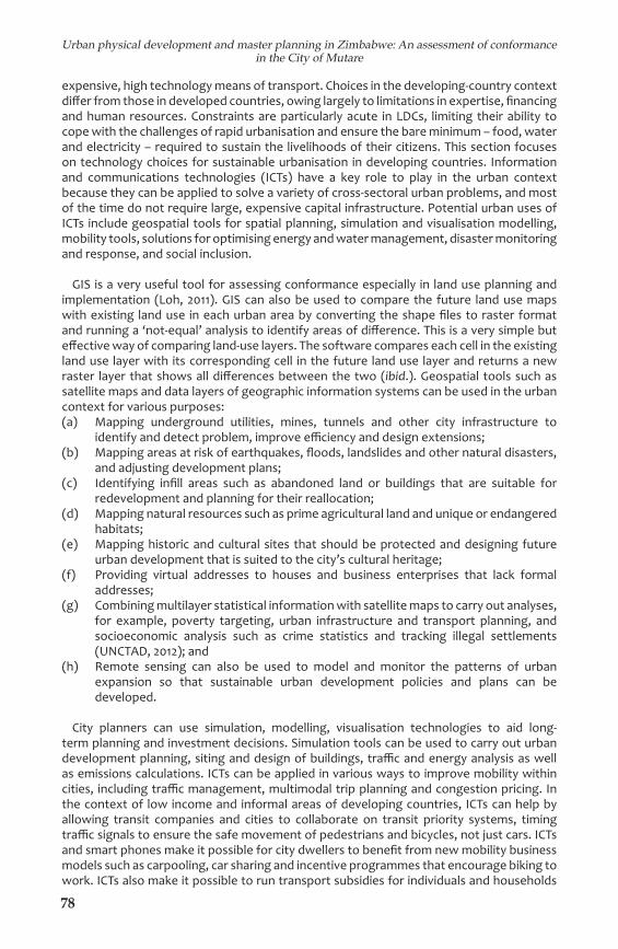
expensive, high technology means of transport. Choices in the developing-country context diff er from those in developed countries, owing largely to limitations in expertise, fi nancing and human resources. Constraints are particularly acute in LDCs, limiting their ability to cope with the challenges of rapid urbanisation and ensure the bare minimum – food, water and electricity – required to sustain the livelihoods of their citizens. This section focuses on technology choices for sustai nable urbanisation in developing countries. Information and communications technologies (ICTs) have a key role to play in the urban context because they can be applied to solve a variety of cross-sectoral urban problems, and most of the time do not require large, expensive capital infrastructure. Potential urban uses of ICTs include geospatial tools for spatial planning, simulation and visualisation modelling, mobility tools, solutions for optimising energy and water management, disaster monitoring and response, and social inclusion.
GIS is a very useful tool for assessing conformance especially in land use planning and implementation (Loh, 2011). GIS can also be used to compare the future land use maps with existing land use in each urban area by converting the shape fi les to raster format and running a ‘not-equal’ analysis to identify areas of diff erence. This is a very simple but eff ective way of comparing land-use layers. The software compares each cell in the existing land use layer with its corresponding cell in the future land use layer and returns a new raster layer that shows all diff e rences between the two (ibid.). Geospatial tools such as satellite maps and data layers of geographic information systems can be used in the urban context for various purposes:(a) Mapping underground utilities, mines, tunnels and other city infrastructure to
identify and detect problem, improve effi ciency and design extensions;(b) Mapping areas at risk of earthquakes, fl oods, landslides and other natural disasters,
and adjusting development plans;(c) Identifying infi ll areas such as abandoned land or buildings that are suitable for
redevelopment and planning for their reallocation;(d) Mapping natural resources such as prime agricultural land and uni que or endangered
habitats;(e) Mapping historic and cultural sites that should be protected and designing future
urban development that is suited to the city’s cultural heritage;(f) Providing virtual addresses to houses and business enterprises that lack formal
addresses;(g) Combining multilayer statistical information with satellite maps to carry out analyses,
for example, poverty targeting, urban infrastructure and transport planning, and socioeconomic analysis such as crime statistics and tracking illegal settlements (UNCTAD, 2012); and
(h) Remote sensing can also be used to model and monitor the patterns of urban expansion so that sustainable urban development policies and plans can be developed.
City planners can use simulation, modelling, visualisation technologies to aid long-term planning and investment decisions. Simulation tools can be used to carry out urban development planning, siting and design of buildings, traffi c and energy analysis as well as emissions calculations. ICTs can be applied in various ways to improve mobility within cities, including traffi c management, multimodal trip planning and congestion pricing. In the context of low income and informal areas of developing countries, ICTs can help by allowing transit companies and cities to collaborate on transit priority systems, timing traffi c signals to ensure the safe movement of pedestrians and bicycles, not just cars. ICTs and smart phones make it possible for city dwellers to benefi t from new mobility business models such as carpooling, car sharing and incentive programmes that encourage biking to work. ICTs also make it possible to run transport subsidies for individuals and households
79
Urban physical development and master planning in Zimbabwe: An assessment of conformance in the City of Mutare
with low incomes that might not be able to aff ord the standard rate for transport services. In summary, the urban challenges in developing countries and possible GIS and remote sensing solutions can be represented in Table 1.
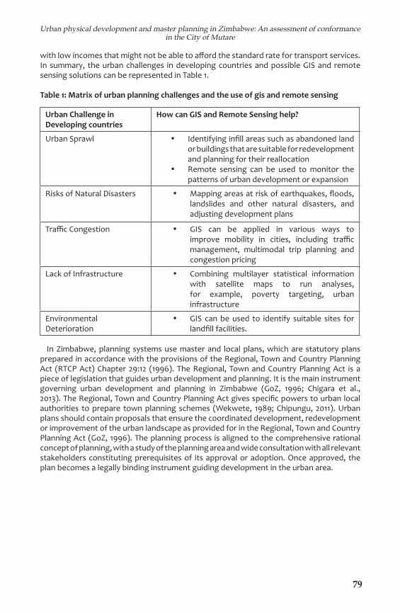
Table 1: Matrix of urban planning challenges and the use of gis and remote sensing
Urban Challenge in Developing countries
How can GIS and Remote Sensing help?
Urban Sprawl • Identifying infi ll areas such as abandoned land or buildings that are suitable for redevelopment and planning for their reallocation
• Remote sensing can be used to monitor the patterns of urban development or expansion
Risks of Natural Disasters • Mapping areas at risk of earthquakes, fl oods, landslides and other natural disasters, and adjusting development plans
Traffi c Congestion • GIS can be applied in various ways to improve mobility in cities, including traffi c management, multimodal trip planning and congestion pricing
Lack of Infrastructure • Combining multilayer statistical information with satellite maps to run analyses, for example, poverty targeting, urban infrastructure
Environmental Deterioration
• GIS can be used to identify suitable sites for landfi ll facilities.
In Zimbabwe, planning systems use master and local plans, which are statutory plans prepared in accordance with the provisions of the Regional, Town and Country Planning Act (RTCP Act) Chapter 29:12 (1996). The Regional, Town and Country Planning Act is a piece of legislation that guides urban development and planning. It is the main instrument governing urban development and planning in Zimbabwe (GoZ, 1996; Chigara et al., 2013). The Regional, Town and Country Plan ning Act gives specifi c powers to urban local authorities to prepare town planning schemes (Wekwete, 1989; Chipungu, 2011). Urban plans should contain proposals that ensure the coordinated development, redevelopment or improvement of the urban landscape as provided for in the Regional, Town and Country Planning Act (GoZ, 1996). The planning process is aligned to the comprehensive rational concept of planning, with a study of the planning area and wide consultation with all relevant stakeholders constituting prerequisites of its approval or adoption. Once approved, the plan becomes a legally binding instru ment guiding development in the urban area.

80
Urban physical development and master planning in Zimbabwe: An assessment of conformance in the City of Mutare
2. Materials and methods
2.1 Study areaThe city of Mutare is located in Manicaland Province, at latitude 18°58’0” and longitude
32°40’0” and is about 265km east of Harare, the capital city of Zimbabwe (Figure 1). The existing city of Mutare boundary encompasses an area of 16,290.75 hectares. The population of the city has increased signifi cantly from just 69,621 in 1982 to 131,367 in 1992 and 187,621 in 2012 (Zimbabwe National Statistics Agency, 2012). This signifi es growth rates of 89% in the fi rst decade and 43% in the last decade. The city of Mutare Council is the city’s Local Planning Authority and it uses a master plan that was approved in 1993 to control physical developments in the city.
Figure 1: The location of the City of Mutare within Mutare district of Zimbabwe
Conformance based approachIn this study, we adopted the conformance based approach to assess the extent to
which master plans and actual land use outcomes match in the city of Mutare, following several steps. First we extracted the spatial land use data for the city of Mutare in a GIS. We obtained the master plan map of the City of Mutare from the Department of Planning and converted the hardcopy master plan into digital form using a scanner at a resolution of 600dpi. We then imported the scanned map into a GIS environment and subsequently georeferenced it based on the UTM Projection, WGS84 Datum and Spheroid. Thereafter, we digitized the proposed land uses on the master plan in a Geographic Information System to extract all the proposed land uses as provided for in the master plan. This data formed the basis for the assessment of land use activities being implemented on the ground. Figure 2 illustrates the proposed land use activities in the City of Mutare based on the 1993 master plan.
81
Urban physical development and master planning in Zimbabwe: An assessment of conformance in the City of Mutare
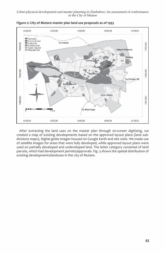
Figure 2: City of Mutare master plan land use proposals as of 1993
After extracting the land uses on the master plan through on-screen digitizing, we created a map of existing developments based on the approved layout plans (land sub-divisions maps), Digital globe images housed on Google Earth and site visits. We made use of satellite images for areas that were fully developed, while approved layout plans were used on partially developed and undeveloped land. The latter category consisted of land parcels, which had development permits/approvals. Fig. 3 shows the spatial distribution of existing developments/landuses in the city of Mutare.

82
Urban physical development and master planning in Zimbabwe: An assessment of conformance in the City of Mutare
Figure 3: Current land uses/developments in the City of Mutare (2014)
2.5 Determination of conformance of physical developments to master plan proposalsWe performed an overlay analysis based on the proposed land use map (Figure 3) and
the existing land use map (Figure 5) to determine the degree of conformance of existing land uses to the land uses provided for in the master plan. We then extracted an error or confusion matrix (a cross-tabulation formed by the overall agreement-disagree ment between existing developments and land use proposals (Silván-Cárdenas & Wang, 2008). From the confusion matrix, we calculated errors of omission and commission, overall conformance and Cohen’s Kappa Coeffi cient as measures of conformance.
Omission error occurs in instances where the proposed land use class on the master plan is not the same as the existing land-use on the ground. The error was calculated by dividing the total of the row’s off -diagonal cell values by the row marginal/total. Commission error exists where the existing land use class on a given area was not the same as the proposed land use class, and it was calculated by dividing the total of the column’s off -diagonal cell values by the column marginal/total.
Overall conformance refers to the proportion of agreement and was calculated by dividing the sum of diagonal cell values by the overall sum. Cohen’s Kappa Coeffi cient refers to the proportion of agreement. This was calculated using the formula in Equation 1(Cohen 1960).
where P represents overall conformance; and Pe represents the proportion of units expected to agree by chance and was calculated using the Equation 2.
where mi represents the sum of row iini represents the sum of column i; and N represents the overall sum.
Equation 1: Cohen’s Kappa Coeffi cient (K) = P - Pe
1 - Pe
Equation 2: Pe = ∑n
Ni=1 mini/N
83
Urban physical development and master planning in Zimbabwe: An assessment of conformance in the City of Mutare
2.6 Mapping the Spatial distribution of Areas of Non-conformanceBased on the overlay operations, we determined both areas of conformance and non-
conformance. To do this, we fi rst determined areas with developments that are outside the designated built-up areas on the master plan by overlaying the proposed built-up area map with the existing developed area map. Next, we performed an overlay analysis to determine non-conformance of existing land uses to land use proposals using conditional statements that combined the entire off -diagonal cells in the confusion matrix.
3. Results
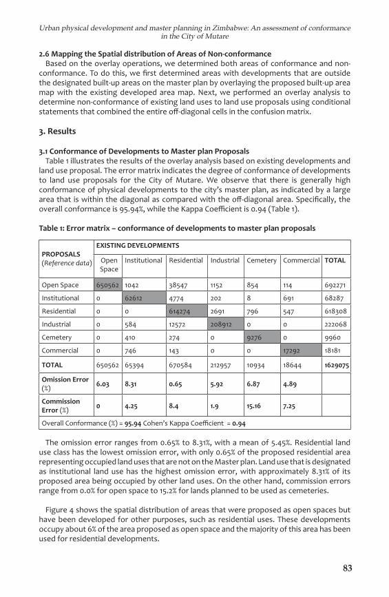
3.1 Conformance of Developments to Master plan ProposalsTable 1 illustrates the results of the overlay analysis based on existing developments and
land use proposal. The error matrix indicates the degree of conformance of developments to land use proposals for the City of Mutare. We observe that there is generally high conformance of physical developments to the city’s master plan, as indicated by a large area that is within the diagonal as compared with the off -diagonal area. Specifi cally, the overall conformance is 95.94%, while the Kappa Coeffi cient is 0.94 (Table 1).
Table 1: Error matrix – conformance of developments to master plan proposals
PROPO SALS (Reference data)
EXISTING DEVELOPMENTS
Open Space
Institutional Residential Industrial Cemetery Commercial TOTAL
Open Space 650562 1042 38547 1152 854 114 692271
Institutio nal 0 62612 4774 202 8 691 68287
Residential 0 0 614274 2691 796 547 618308
Industrial 0 584 12572 208912 0 0 222068
Cemetery 0 410 274 0 9276 0 9960
Commercial 0 746 143 0 0 17292 18181
TOTAL 650562 65394 670584 212957 10934 18644 1629075
Omission Error (%) 6.03 8.31 0.65 5.92 6.87 4.89
Commission Error (%) 0 4.25 8.4 1.9 15.16 7.25
Overall Conformance (%) = 95.94 Cohen’s Kappa Coeffi cient = 0.94
The omission error ranges from 0.65% to 8.31%, with a mean of 5.45%. Residential land use class has the lowest omission error, with only 0.65% of the proposed residential area representing occupied land uses that are not on the Master plan. Land use that is designated as institutional land use has the highest omission error, with approximately 8.31% of its proposed area being occupied by other land uses. On the other hand, commission errors range from 0.0% for open space to 15.2% for lands planned to be used as cemeteries.
Figure 4 shows the spatial distribution of areas that were proposed as open spaces but have been developed for other purposes, such as residential uses. These developments occupy about 6% of the area proposed as open space and the majority of this area has been used for residential developments.

84
Urban physical development and master planning in Zimbabwe: An assessment of conformance in the City of Mutare
Figure 4: Areas with developments outside designated built-up areas
An assessment of the overall non-conformance of physical developments to master plan proposals i.e., the total off -diagonal cells in the error matrix (Table 1) shows that close to 4% of the whole urban landscape does not match the land uses proposed in the master plan. Furthermore, we observe that most of the non-conformance occurred when land reserved for open space was occupied by other land uses, as shown in Figure 5.
Figure 5: Spatial distribution of areas where there was non-confor mance of developments to land-use proposals
85
Urban physical development and master planning in Zimbabwe: An assessment of conformance in the City of Mutare
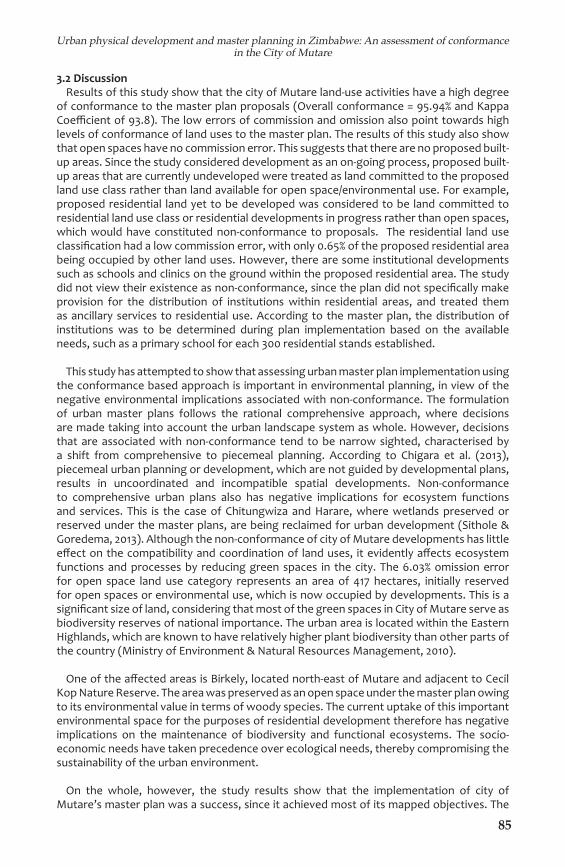
3.2 DiscussionResults of this study show that the city of Mutare land-use activities have a high degree
of conformance to the master plan proposals (Overall conformance = 95.94% and Kappa Coeffi cient of 93.8). The low errors of commission and omission also point towards high levels of conformance of land uses to the master plan. The results of this study also show that open spaces have no commission error. This suggests that there are no proposed built-up areas. Since the study considered development as an on-going process, proposed built-up areas that are currently undeveloped were treated as land committed to the proposed land use class rather than land available for open space/environmental use. For example, proposed residential land yet to be developed was considered to be land committed to residential land use class or residential developments in progress rather than open spaces, which would have constituted non-conformance to proposals. The residential land use classifi cation had a low commission error, with only 0.65% of the proposed residential area being occupied by other land uses. However, there are some institutional developments such as schools and clinics on the ground within the proposed residential area. The study did not view their existence as non-conformance, since the plan did not specifi cally make provision for the distribution of institutions within residential areas, and treated them as ancillary services to residential use. According to the master plan, the distribution of institutions was to be determined during plan implementation based on the available needs, such as a primary school for each 300 residential stands established.
This study has attempted to show that assessing urban master plan implementation using the conformance based approach is important in environmental planning, in view of the negative environmental implications associated with non-conformance. The formulation of urban master plans follows the rational comprehensive approach, where decisions are made taking into account the urban landscape system as whole. However, decisions that are associated with non-conformance tend to be narrow sighted, characterised by a shift from comprehensive to piecemeal planning. According to Chigara et al. (2013), piecemeal urban planning or development, which are not guided by developmental plans, results in uncoordinated and incompatible spatial developments. Non-conformance to comprehensive urban plans also has negative implications for ecosystem functions and services. This is the case of Chitungwiza and Harare, where wetlands preserved or reserved under the master plans, are being reclaimed for urban development (Sithole & Goredema, 2013). Although the non-conformance of city of Mutare developments has little eff ect on the compatibility and coordination of land uses, it evidently aff ects ecosystem functions and processes by reducing green spaces in the city. The 6.03% omission error for open space land use category represents an area of 417 hectares, initially reserved for open spaces or environmental use, which is now occupied by developments. This is a signifi cant size of land, considering that most of the green spaces in City of Mutare serve as biodiversity reserves of national importance. The urban area is located within the Eastern Highlands, which are known to have relatively higher plant biodiversity than other parts of the country (Ministry of Environment & Natural Resources Management, 2010).
One of the aff ected areas is Birkely, located north-east of Mutare and adjacent to Cecil Kop Nature Reserve. The area was preserved as an open space under the master plan owing to its environmental value in terms of woody species. The current uptake of this important environmental space for the purposes of residential development therefore has negative implications on the maintenance of biodiversity and functional ecosystems. The socio-economic needs have taken precedence over ecological needs, thereby compromising the sustainability of the urban environment.
On the whole, however, the study results show that the implementation of city of Mutare’s master plan was a success, since it achieved most of its mapped objectives. The
86
Urban physical development and master planning in Zimbabwe: An assessment of conformance in the City of Mutare
fi ndings show that the master plan is eff ective in guiding the physical urban development of the city of Mutare. Although this study focused on the city of Mutare, it can also be useful to other urban local planning authorities, as the method and materials used in the study can form the basis for assessing compliance to statutory developmental plans. Studies or assessments of this nature are important in monitoring and evaluating implementation of urban plans. In addition, the exercise can also be done at local or neighbourhood level of the city to determine the linkage between approved layout plans/land subdivisions and the actual developments on the individual stand/subdivision.
4. ConclusionThis study used a conformance based approach to evaluate the extent to which urban
master plans are being implemented, using the City of Mutare as a case study. This was based on the premise that conformance between plans and outcomes is the intent of most planning processes. The main objective of this study was to assess the conformance of physical developments of city of Mutare to the Urban Master plan Land Use Proposals. The results show that implementation of the city of Mutare’s master plan is a success, in spite of non-conformance in some areas of the city. The master plan managed to guide the physical development in the city, suggesting the eff ectiveness of the planning system of Mutare City Council. The planning system is in line with planning policy and legislation, which requires compliance to master plan proposals.
There is need, however, to continuously monitor the land use outcomes to ensure that developments conform to master plan proposals. Environmental needs are often overlooked by Local Planning Authorities in pursuance of a community’s socio-economic needs, since ecosystem services are often enjoyed without being given an economic value (Chiesura, 2003). Consequently, reserved open spaces end up being occupied by other uses that generate revenue for Local Planning Authorities. In order to achieve sustainable urban environments, there is need to involve other organisations responsible for environmental protection, such as the Environmental Management Agency (EMA), in the management of land reserved as open spaces or for environmental use. Any change(s) to land reservation should be eff ected subject to EMA approval and after considering its eff ects on the urban landscape as a whole.
The assessment of conformance to master plans is necessary for all urban areas, considering the negative environmental implications associated with non-conformance. This will also determine the extent to which Urban Local Authorities are following planning policy and legislation. The formulation of the new master plan currently in progress should consider the implementation successes and failures of the current master plan highlighted in this study. The plan should focus on attaining a sustainable urban environment and creating a balance between ecological and socio-economic needs. This can be achieved by planning at an ecosystemic scale rather than limiting planning focus within the new administrative city boundary.
ReferencesAlexander, E. R., & Faludi, A. (1988). Planning and plan imple men tation: notes on evaluation
criteria. Environment and Planning B: Plan ning and Design, 16, 127-140.Alterman, R., & Hill, M. (1978). Implementation of Urban Land Use Plans. Journal of the
American Institute of Planners, 44(3), 274-285.Brody, S. D., & Highfi eld, W. E. (2005). Does planning work? Testing the implementation
of local environmental planning in Florida. Journal of the American Planning Association, 71, 159-175.
Brody, S. D., Highfi eld, W. E., et al. (2006). Planning at the urban fringe: An examination of the factors infl uencing nonconforming development patterns in southern Florida. Environment and Planning B: Planning & Design, 33, 75-96.
87
Urban physical development and master planning in Zimbabwe: An assessment of conformance in the City of Mutare
Chiesura, A. (2003). The role of urban parks for sustainable city. Land scape Urban Planning. Landscape Urban Planning, 68, 128-138.
Chigara, B., Magwaro-Ndiweni, L., et al. (2013). An analysis of the eff ects of piecemeal planning on development of small urban centres in Zimbabwe: Case study of plumtree. International Journal of Mana ge ment and Social Sciences Research, 2(4), 2319-4421.
Cohen, B. (2004). Urban Growth in Developing Countries. A Review of Current Trends and a Caution Regarding Existing Forecasts. World Development , 32(1), 23-51.
Cohen, B. (2006). Urbanisation in developing countries: Current trends, fu ture projections and key challenges for sustainability. Technology in Society, 28, 63-80.
Chipungu, L. (2011). Insights into urban development control chal lenges: A case study of Operation Murambatsvina/ Restore Order in Zim babwe. The Built & Human Environment Review, 4(2), 17-32.
Chipungu, L. (2011). Insights into urban development control chal len ges: A case study of Operation Murambatsvina/ Restore Order in Zim bab we. The Built & Human Environment Review, 4(Special Issue 2).
Cohen, J. (1960). A coeffi cient of agreement for nominal scales. Educa tional and Psychological Measurement, 20(1), 37-46.
Department of Economic and Social Aff airs – Population Division (2012). World Urbanisation Prospects, the 2011 revision highlights. ESA/P/WP/224. New York: United Nations Publication.
Diaw, K., Nnkya, T., et al. (2002). Planning education in sub-Saharan Af ri ca: Responding to the demands of a changing context. Planning Prac tice & Research, 17(3), 337-348.
Economic and Social Commission for Asia and the Pacifi c, Economic Com mission for Latin America and the Caribbean, UN-HABITAT and Ur ban Design Lab (2011). Are we building competitive and liveable cities? Guidelines for developing eco-effi cient and socially inclusive infrastruc ture. ST/ESCAP/–ISBN 978-974-680-291-8. Thailand: United Nations.
Faludi, A. (2000). The performance of spatial planning. Planning Prac tice & Research, 15(4), 299-318.
Food and Agriculture Organisation of the United Nations (2012). Gro wing greener cities in Africa. First status report on urban and peri-ur ban horticulture in Africa. Rome. Available at http://www.fao.org/docrep/016/i3002e/i3002e.pdf
Food and Agriculture Organisation of the United Nations (2012). Gro wing Greener Cities in Africa. First Status Report on Urban and Peri-urban Horticulture in Africa. Rome. Available at http://www.fao.org/docrep/016/i3002e/i3002e.pdf
Glaeser, E. L. (2011). Triumph of the city: How our greatest invention ma kes us richer, smarter, greener, healthier, and happier. New York: The Penguin Press.
GoZ (1996). Regional, Town and Country Planning Act, Chapter 29,12. D. o. P. Planning. Harare: Government Printers.
Green Media (2012). Sustainable cities – building cities for the future. London: Green Media Ltd.
Hoornweg, D. & Perinaz, B.-T. (2012). What a waste: A global review of solid waste management. Urban Development Series Knowledge Pa pers, No. 15. Washington, D.C.: World Bank.
Laurian, L., Day, M., et al. (2004a). What drives plan implementation? Plans, planning agencies and developers. Journal of Environmental Plan ning and Management, 47(4), 555-577.
Laurian, L., Day, M., et al. (2004). Evaluating plan implementation – A con formance-based methodology. American Planning Association, 70, 471-480.

88
Urban physical development and master planning in Zimbabwe: An assessment of conformance in the City of Mutare
Linares, C. A. (2003). Institutions and the urban environment in deve loping countries: Challenges, trends and transitions. Harare: F and ES Pu blications.
Loh, C. G. (2011). Assessing and interpreting nonconformance in land-use planning implementation. Planning Practice & Research, 26(3), 271-287.
McMichael, A. J. (2000). The urban evironment and health in a world of increasing globalization: Issues for developing countries. Bulletin of the World Health Organization, 78(9), 1118-1126.
Ministry of Environment & Natural Resources Management (2010). Zimbabwe’s fourth national report to the convention on biological diversity. Harare: Government of Zimbabwe.
Oliveira, V., & Pinho, P. (2009). Evaluating plans, processes and results. Planning Theory & Practice, 10(1), 35-63.
Oliveira, V., & Pinho, P. (2010). Evaluation in urban planning: Advances and prospects. Journal of Planning Literature, 24(4), 343-361.
Ondiege, P., & Okpala, D. (1999). Reassessment of urban planning and development regulations in African cities. Nairobi: UN-HABITAT.
Roth, I. J. (2012). Just cities. The world’s problems need urban solu tions. Bonn: Friedrich Ebert Stiftung.
Satterthwaite, D. (2007). The transition to a predominantly urban world and its underpinnings. International Institute for Environment and Development (IIED) – Human Settlements Discussion Series. Lon don: IIED. Available at http://pubs.iied.org/pdfs/10550IIED.pdf
Silván-Cárdenas, J. L., & Wang, L. (2008). Sub-pixel confusion – uncer tainty matrix for assessing soft classifi cations. Remote Sensing of Envi ron ment, 112, 1081-1095.
Sithole, A., &and B. Goredema (2013). Building in wetlands to meet the housing demand and urban growth in Harare. International Jour nal of Humanities and Social Science, 3(8), Special-Issue.
Talen, E. (1996a). Do plans get implemented? A review of evaluation in planning. Journal of Planning Literature, 10, 248-259.
Talen, E. (1996b). After the plans: methods to evaluate the implemen tation success of plans. Journal of Planning Education and Research, 16, 79-91.
Talen, E. (1997). Success, failure, and conformance: An alternative ap proach to planning evaluation. Environment and Planning B: Plan ning and Design, 24, 573-587.
Thapa, S., Marshall, F., & Stagl, S. (2010). Understanding peri-urban sus tainability: The role of the resilience approach. STEPS Working Pa per 38. Brighton: STEPS Centre.
Tian, L., & Shen, T. (2011). Evaluation of plan implementation in the tran sitional China: A case of Guangzhou city master plan. Cities, 28, 11-27.
UNCTAD (2012). Geospatial science and technology for development with a focus on urban development, land administration and disaster risk management. UNCTAD/DTL/STICT/2012/3. New York and Geneva: United Nations.
United Nations Environmental Programme (2012). Building design and construction: forging resource effi ciency and sustainable development. New York: United Nations.
UNCTAD (2012). Geospatial science and technology for development with a focus on urban development, land administration and disaster risk management. UNCTAD/DTL/STICT/2012/3. New York and Geneva: United Nations.
United Nations Population Fund (2008). State of world population 2007 – unleashing the potential of urban growth. ISBN 978-0-89714-807-8. New York: United Nations.
Wekwete, K. H. (1989). Physical planning in Zimbabwe: A Review of the legislative, administrative and operational framework. Third World Plan ning Review, 11(1), 49-69.
World Bank (2012). Urban risk assessments. understanding disaster and climate risk in cities. Census 2012 National Report. Washington, D.C.: Zimbabwe National Statis tics Agency.