urban design brief - cambridge, ontario...urban design brief october 2018 intermarket industrial...
TRANSCRIPT

URBAN DESIGN BRIEF DRAFT PLAN OF SUBDIVISION Intermarket Phase II Lands City of Cambridge Date: October 2018 Prepared for: Intermarket CAM Limited Prepared by: MacNaughton Hermsen Britton Clarkson Planning Limited (MHBC) 540 Bingemans Centre Drive, Suite 200 Kitchener, Ontario T: 519.576.3650 F: 519.576.0121 Our File 0667A


i Urban Design Brief October 2018 215 Allendale Road – Intermarket Phase II Industrial Lands
CONTENTS 1.0 INTRODUCTION ........................................................................................................................................................................................... 3
2.0 CONTEXT ANALYSIS ................................................................................................................................................................................. 4
2.1 Site .......................................................................................................................................................................................................................... 4
2.2 Surrounding Land Uses ............................................................................................................................................................................. 5
3.0 GOALS AND OBJECTIVES ....................................................................................................................................................................... 7
4.0 SUBDIVISON DESIGN ................................................................................................................................................................................ 9
5.0 POLICY REVIEW ......................................................................................................................................................................................... 10
5.1 CITY OF CAMBRIDGE OFFICIAL PLAN: ............................................................................................................................................ 10
Healthy and Livable Communities .................................................................................................................................................... 10
Transit Oriented Development ............................................................................................................................................................ 10
Site Development and Buildings ........................................................................................................................................................ 11
Sustainable Design ...................................................................................................................................................................................... 12
Accessibility/Universal Design .............................................................................................................................................................. 12
Safety .................................................................................................................................................................................................................... 12
Parking ................................................................................................................................................................................................................. 12
Signage ............................................................................................................................................................................................................... 13
Public Art ........................................................................................................................................................................................................... 13
5.2 CITY OF CAMBRIDGE INDUSTRIAL GUIDELINES ....................................................................................................................... 15
6.0 CONCLUSION ............................................................................................................................................................................................ 19
Appendix A Draft Plan of Subdivision

Urban Design Brief October 2018 Intermarket Industrial Subdivision – Phase II 3
1.0 INTRODUCTION MacNaughton Hermsen Britton Clarkson Planning Limited (hereinafter “MHBC”) has prepared this Urban Design Brief in support of the application for Draft Plan of Subdivision for the Intermarket Phase II Industrial Business Park, owned by Intermarket CAM Limited. The property is municipally addressed as 215 Allendale Road in the City of Cambridge and is hereinafter referred to as the “subject lands”.
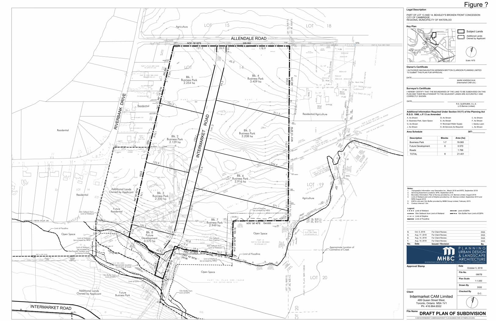
The application for Draft Plan of Subdivision has been submitted to create 7 industrial blocks on 21.3 hectares of land along the planned Intermarket Road. The application for Draft Plan of Subdivision will facilitate the second phase of the proposed Creekside Corporate Campus in the northwestern corner of the City of Cambridge.
The proposed Draft Plan of Subdivision application will implement the recently approved Official Plan and Zoning Amendments for the subject property.
Site plan approval will be required in the future to address more detailed building and site design matters. This brief/guideline will assist in providing direction for the future site plan.
This design brief has been prepared in accordance with the City of Cambridge Terms of Reference for Design Briefs.
Urban Design Brief October 2018 Intermarket Industrial Subdivision – Phase II 4
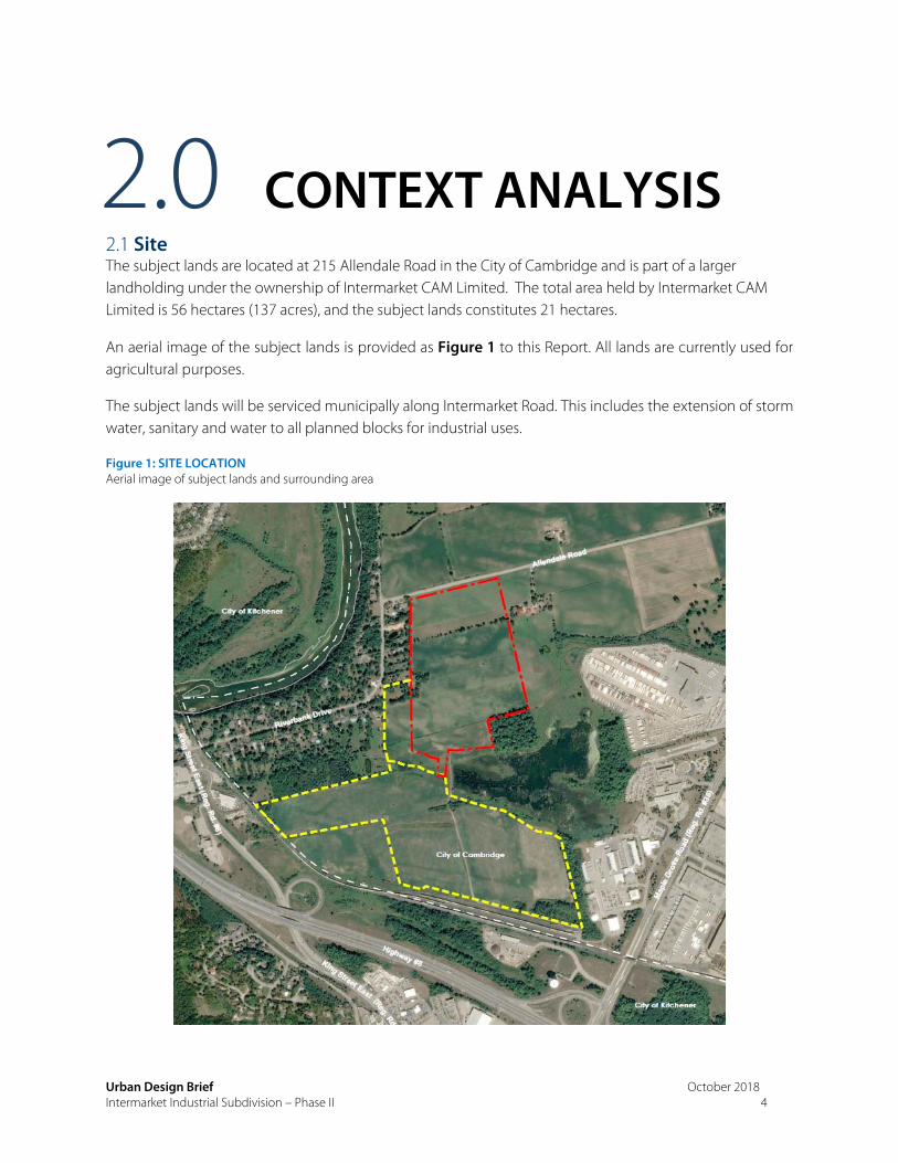
2.0 CONTEXT ANALYSIS 2.1 Site The subject lands are located at 215 Allendale Road in the City of Cambridge and is part of a larger landholding under the ownership of Intermarket CAM Limited. The total area held by Intermarket CAM Limited is 56 hectares (137 acres), and the subject lands constitutes 21 hectares.
An aerial image of the subject lands is provided as Figure 1 to this Report. All lands are currently used for agricultural purposes.
The subject lands will be serviced municipally along Intermarket Road. This includes the extension of storm water, sanitary and water to all planned blocks for industrial uses.
Figure 1: SITE LOCATION Aerial image of subject lands and surrounding area

Urban Design Brief October 2018 Intermarket Industrial Subdivision – Phase II 5
2.2 Surrounding Land Uses The subject lands are approximately 21 hectares in size and legally described as Part of Lot 14, Beasley’s Broken Front Concession, City of Cambridge, Regional Municipality of Waterloo, and are located in the northwest part of the City of Cambridge. The lands are currently used for agricultural purposes, but are located in the Urban Area.
Please refer to the context plan shown in Figure 2 showing the subject property and surrounding land uses. Uses that are adjacent to the subject lands include:
North: Immediately to the north of the subject property is Allendale Road. To the north of Allendale Road are lands currently used for agricultural purposes, but have been designated for employment uses.
East: To the east is an existing farm.
South: There are natural features which abut the subject property on the south east corner. This environmental feature is a wetland area which is identified as a core environmental feature.
Also to the south of the property is Freeport Creek. South of the creek is the Phase I of the Intermarket Development which has been approved for industrial development.
West: Immediately to the west of the site are rural residential properties with frontage onto Riverbank Drive. One of the abutting parcels includes a portion of 245 Riverbank Drive which is located outside of the designated urban area and designated as Rural Residential in the Cambridge Official Plan.
The subject lands are in close proximity to major transportation corridors. Maple Grove Road is to the east and is a four lane major arterial road that provides connections to Highway 8, Highway 401, Highway 24 (to Guelph) and Highway 7 via Fountain Street. King Street is to the south and west and will have a connection via the planned Intermarket Road which provides connections south to Highway 8 and the 401.
Maple Grove is a transit route and Grand River Transit provides service to the Cambridge Business Park area. The Ion Phase 2 Light rail transit project proposes a station connection at Sportsworld which will provide a rapid transit connection through the Region of Waterloo.
In summary, the proposed industrial subdivision is located within a planned industrial park and close to major transportation corridors.

Urban Design Brief October 2018 Intermarket Industrial Subdivision – Phase II 6
Figure 2: CONTEXT PLAN Subject Property Location and Surrounding Land Uses

Urban Design Brief October 2018 Intermarket Industrial Subdivision – Phase II 7
3.0 GOALS AND OBJECTIVES
Design Goals/Objectives:
The goal for the development of the land is to provide for
1. Create an industrial subdivision design that is sympathetic to adjacent sensitive uses.
2. Create a strong and visually appealing street edge along Allendale Road and Intermarket Road.
3. Provide gateway/priority blocks for key blocks that define the subdivision.
4. Provide for a development that is accessible by all forms of transportation.
5. Provide for a block pattern where building massing that is oriented towards the street edges to enhance the pedestrian experience.
6. Create a defined right of way through subdivision to divert traffic away from established rural residential area.
7. Provide a strong business park edge.

Urban Design Brief October 2018 Intermarket Industrial Subdivision – Phase II 8
Industrial building in Olathe, Kansas (opus-group.com)
Urban Design Brief October 2018 Intermarket Industrial Subdivision – Phase II 9
4.0 SUBDIVISON DESIGN
The proposed draft plan of subdivision for the Phase II lands provides for a number of blocks intended for employment/industrial uses. All blocks will have direct access to the future Intermarket Road (currently undergoing the detailed design process under the direction of the City of Cambridge).
The proposed draft plan of subdivision includes the following:
26.0m road right of way planned for Intermarket Road
Seven (7) blocks dedicated to business park use, which range from 2.1 hectares to 3.4 hectares in size.
One additional block (shown as Block 8 on the draft plan of subdivision) planned as a future development block.
Please refer to Appendix A to review the submitted Draft Plan of Subdivision.
Urban Design Brief October 2018 Intermarket Industrial Subdivision – Phase II 10
5.0 POLICY REVIEW 5.1 CITY OF CAMBRIDGE OFFICIAL PLAN:
The City of Cambridge Official Plan has established a set of Urban Design policies that apply to all developments in the City. Below is a summary of how the draft plan of subdivision and future block/site design meets the intent of the urban design policy from the Official Plan.
Healthy and Livable Communities Policy 5.2 states that design of the built environment will promote sustainable, healthy and active living and that the integration of pedestrian and cycling facilities into new developments is supported.
An Environmental Assessment has been completed to plan for a right of way that will collect traffic created by the employment lands and direct it away from the existing rural residential subdivision on Riverbank Drive. This road (Intermarket Road) will bisect the subject property and provide for a connection to King Street and Allendale Road (which plans for a bike route upon future road upgrades) and extends further to Middleblock Road (through the rest of the employment lands). The creation of this new street will provide direct connection to major streets which offer public transit and alternative transportation infrastructure.
Each block within the subdivision will be developed with consideration for sustainable design, health and active living. Sustainability will be encouraged through building and site design, by promoting the incorporation of native plant species, onsite infiltration and energy efficient building design.
Accessible pedestrian connections to each block will be considered through the site plan approval process that will provide direct connection to the public realm.
Transit Oriented Development Policy 5.3 provides direction for development located within a Major Transit Area or within walking distance to one or more - higher frequency transit stops.
Although the site is not located directly within a major transit area, it is located in close proximity to the second stage of the ION planned Light Rail Transit Route with a stop located near the highway 8 interchange on Maple Grove Road. It is anticipated that additional transit will be available to connect from the station to the industrial subdivision as it will become a major employment centre in the City of Cambridge.
Safe pedestrian environments will be planned within each employment block, as well as sidewalks on both sides of Intermarket Road to provide connection to future public transit connections to support the planned network.

Urban Design Brief October 2018 Intermarket Industrial Subdivision – Phase II 11
Views and Vistas: Policy 5.4 of the Official Plan provides direction for preserving views and vistas relating to cultural heritage landscapes and buildings. There are no significant views and vistas or buildings with cultural heritage value that will directly be impacted by the proposed development. Riverbank Drive is recognized in the City’s Heritage Master Plan as a scenic route. No changes to Riverbank Road are proposed by the plan of subdivision on the subject lands. The construction of Intermarket Road will divert daily traffic to and from the employment centre from the established rural residential neighbourhood along Riverbank Drive.
Public Realm: Policy 5.5 states that the City will ensure that sustainable design and opportunities to enhance the public realm are addressed at the design stage.
A 1.766 hectare block of land will be conveyed to the City of Cambridge for the development of Intermarket Road. The location of the road was identified through an approved Environmental Impact Assessment and the detailed design is currently being completed under the direction of the City of Cambridge. Detailed design of the blocks fronting Intermarket Road will occur through the site plan approval process and the landscape design and appropriate interface with the public realm will be determined at that time.
Gateways: Policy 5.6 of the Official Plan applies to the design of gateways into the City and into specific areas of the City.
Two blocks on the proposed draft plan of subdivision have been identified as gateways from Allendale Road into the Phase II industrial lands (Blocks 1 and 4). Details of the gateway features will be determined through the site plan process, the gateway blocks shall provide enhanced architectural treatment and landscaping on the street fronting facades and shall be oriented to the street frontage (on Allendale Road and Intermarket Road).
Site Development and Buildings Policy 5.7 of the Official Plan provides guidance for site development and building design.
It is anticipated that through the site plan approval process the proposed buildings and site planning will address Policy 5.7 relating to site development and buildings.
The proposed plan of subdivision provides for blocks with a size, orientation and frontage on public streets that would allow for development that would meet the site development and urban design policies in section 5.7.
Urban Design Brief October 2018 Intermarket Industrial Subdivision – Phase II 12
Sustainable Design Policy 5.8 of the Official Plan encourages energy efficiency and sustainability in neighbourhood, site, building and roof design.
At this stage of the development process, detailed building and site design have not been completed but will be considered through the site plan approval and building permit process.
The design of the proposed subdivision minimizes the need for new road connections as all proposed blocks front onto the Intermarket Road right of way.
The engineering design will meet the City of Cambridge standards for stormwater management.
Accessibility/Universal Design Policy 5.9 of the Official Plan requires that all new development be consistent with the standards and regulations of the Accessibility for Ontarians with Disabilities Act, 2005 (AODA) and the Ontario Building Code (OBC).
The detail of the AODA features will be confirmed through the site plan process to ensure minimum standards for parking, sidewalks and lighting are met.
Safety Section 5.10 of the Official Plan requires site development should incorporate crime prevention design standards such as principles of Crime Prevention Through Environmental Design (CPTED) to ensure that new developments address safe living and working environments.
Although not detailed at the stage in the planning process, the site designs will consider CPTED principles through providing natural surveillance of outdoor spaces, avoid creating secluded areas, provide clearly marked access and egress areas and provide proper lighting.
Parking Section 5.11 of the Official Plan provides policy relating to the parking design for site development.
It is anticipated that parking areas will be accessed from Intermarket Road. Parking areas will be located in the front and side of buildings (screened by a landscape buffer and truck bays should be located to the side and rear of buildings and screened from view of the street. The proposed blocks have sufficient size to allow for parking to be screened from public streets and allow for treatment to break up large parking areas and reduce the heat island effect.
Issues of lighting, pedestrian movement and bicycle parking will be addressed through the site plan approval process.
Urban Design Brief October 2018 Intermarket Industrial Subdivision – Phase II 13
Signage Policy 5.12 encourages signage to be incorporated into the architectural design of the building. Signage has not been incorporated into the plan of subdivision and will be addressed during the site plan process for each block. It is expected that signage will be located on the front elevation of buildings as well as on free standing signs near the entrance to the site. All signage will follow the City of Cambridge Sign By-law.
The provisions of policy 5.12 will be met through the detailed site plan process.
Public Art Public Art is encouraged through throughout the City and into future development plans. The details of the site design have yet to be determined. The opportunity for public art will be considered as part of the detailed site design and may be incorporated into the site features. These details will be determined during the site plan process stage of the development.
The proposed draft plan of subdivision complies with the city’s urban design policies for new development. Detailed site design will occur through the site plan approval process. The design of the subdivision and the size and orientation of the proposed blocks and the fact that each block has frontage on Intermarket Road allows for the achievement of the more detailed site plan policies.
Urban Design Brief October 2018 Intermarket Industrial Subdivision – Phase II 14
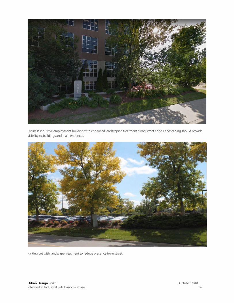
Business industrial employment building with enhanced landscaping treatment along street edge. Landscaping should provide visibility to buildings and main entrances.
Parking Lot with landscape treatment to reduce presence from street.
Urban Design Brief October 2018 Intermarket Industrial Subdivision – Phase II 15
5.2 CITY OF CAMBRIDGE INDUSTRIAL GUIDELINES
The City of Cambridge Industrial Design Guidelines were prepared for the L.G. Lovell Industrial Park, Pinebush Subdivision and Cambridge Business Park’s Maple Grove Subdivision and Boxwood Business Campus. However the City has identified that the same design principles should apply to new business industrial parks within the City. A summary of how the proposed draft plan of subdivision complies with the City’s Industrial Guidelines is provided below.
Business Park Edge
The Industrial Guidelines express the need to provide a high quality business park for the surrounding land uses along the “Business Park edge”. The edge of the Phase II Intermarket lands is along Allendale Road and along the rear of the properties facing Riverbank Drive. The blocks facing Allendale Road have sufficient size and orientation to provide for enhanced landscaping on all street frontages as well as enhanced façade design. These will be detailed through the site plan approval process.
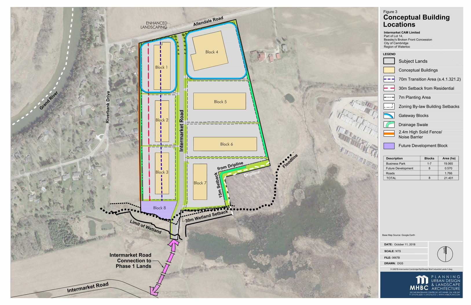
The interface with the residential properties at the western edge of the plan is addressed through the site specific zoning regulations that require increased setbacks and buffers (please refer to Figure 3). The orientation of the blocks allows for there to be transition measures.
As shown on Figure 3, the blocks are sized and oriented such that they can be designed as gateways and allow for landscaping along both frontages. The entrances to these blocks can be located off Intermarket Road away from the intersection of Allendale Road and Intermarket Road. These buildings/sites will act as a precedent for the character of the rest of the industrial subdivision.
Industrial Park Gateway
Gateway blocks are identified as Blocks 1 and 4 on the Draft Plan of Subdivision. These blocks will act as a primary entrance to the Phase II Intermarket Industrial subdivision. Gateway blocks shall provide enhanced architectural treatment on the street fronting facades and shall be oriented to the street frontage.
As shown on Figure 3 of the report the building mass will be pulled towards the street edges (front yard and exterior side yard) and will plan for enhanced landscaping along both frontages. Parking is planned within the front yard and buffered along the street edge, while loading bays will be located at the back and screened from the view of the street. The entrances to these blocks will be located off of Intermarket Road away from the intersection of Allendale Road and Intermarket Road. These buildings/sites will act as a precedent for the character of the rest of the industrial subdivision.
A
lle
n
d
a
le
R
o
a
d
Riverb
an
k D
rive
Block 4
Block 5
Block 6
Block 7In
te
rm
ark
et R
oa
d
Intermarket Road
Connection to
Phase 1 Lands
fr
o
m
D
r
ip
lin
e
G
r
a
n
d
R
i
v
e
r
In
te
rm
a
rk
e
t R
o
a
d
Block 8
Block 1
Block 2
Block 3
L
i
m
i
t
o
f
W
e
t
l
a
n
d
3
0
m
W
e
tla
n
d
S
e
tb
a
c
k
F
l
o
o
d
l
i
n
e
1
5
m
S
e
tb
a
c
k
D
r
ip
lin
e
ENHANCEDLANDSCAPING
DATE: October 11, 2018
north
FILE: 0667B
K:\0667B-Intermarket-Cambridge\Rpt\Design Brief Industrial Lands 3.dwg
DRAWN: DGS
SCALE: NTS
Base Map Source: Google Earth
LEGEND
Subject Lands
Intermarket CAM Limited
Part of Lot 14,
Beasley's Broken Front Concession
City of Cambridge
Region of Waterloo
Figure 3
Conceptual Building
Locations
Area (ha)BlocksDescription
Roads
TOTAL
Business Park 1-7
8
19.065
1.766
21.401
Future Development 0.5708
Conceptual Buildings
Gateway Blocks
30m Setback from Residential
7m Planting Area
70m Transition Area (s.4.1.321.2)
Drainage Swale
Zoning By-law Building Setbacks
2.4m High Solid Fence/
Noise Barrier
Future Development Block
Urban Design Brief October 2018 Intermarket Industrial Subdivision – Phase II 17
Industrial Park Streetscape
The City of Cambridge’s vision for the Industrial Park Streetscape includes building sites on open landscaped lawns.
The guidelines also encourage informal streetscape planting to allow for views of the main building façade, but encourages enhanced landscaping to screen the parking areas and loading areas from the street, but allow for sight lines to view the main façade of the building.
The streetscape/landscape will be developed during the site plan design stages of the individual blocks. The landscape design will be encouraged to be consistent along the frontage of all blocks to create a seamless design for the streetscape. The proposed blocks are sized and oriented such that these guidelines can be achieved though the design process.
Industrial Building Architecture
The Industrial Guidelines provide direction relating to the building materials and architecture planned for the industrial subdivision. The guidelines state that buildings should be design with clear lines and constructed of preferred materials such as glass, manufactured or natural stone and precast concrete. Other materials may be used but will be reviewed during the design stages.
Due to the potential large scale and massing of the buildings within an industrial subdivision, the guidelines provide direction to developments to consider a design that includes both office and industrial plans as a unified architectural treatment. If not possible, the guidelines encourage the office portion of the building to be designed as the focal point with a neutral background of plant architecture.
The above architectural elements will be reflected during the site plan approval process.
6.2 INDUSTRIAL DESIGN – SITING CONCEPT
To achieve the overall vision of the Industrial Guidelines, the City of Cambridge has developed detailed siting guidelines for the industrial block/site designs within the industrial subdivision.
This section of the guidelines provides recommendations for building setbacks, landscape buffer strips, service areas and outdoor storage, vehicular access, fencing, drainage, parking, lighting, natural features, priority blocks, design style, massing, screening of rooftop equipment and materials and colours.
All of the above guidelines will be considered in detail through the site plan process.
To further regulate the proposed development, the City of Cambridge has passed site specific Zoning By-laws that regulate the subdivision and site development of the subject lands. These by-laws specifically are:
S.4.1.341.1 S.4.1.341.2

Urban Design Brief October 2018 Intermarket Industrial Subdivision – Phase II 18
Both site specific Zoning By-laws provide minimum building setbacks from lot lines beyond the typical M3 zone, but also provides additional regulations to help mitigate conflicts between adjacent uses.
The site specific policy regulate the lands to the west of Intermarket Road (as shown on Figure 3) Within the lands to the west of Intermarket Road is a 70m transition area. This area has been established to separate the proposed industrial uses from the sensitive residential uses which abut the site to the west. Within this transition area the following site regulations have been established:
A solid fence or noise barrier wall be established not less than 2.4 metres (7.87 feet) in height along the property line with a 7 metre (22.9 foot) wide planting strip (including approved stormwater management) on the employment lands shall be provided in the ‘transition area’ when abutting a sensitive (ie. Residential) land use;
Industrial uses are only permitted within an enclosed building; No outdoor storage of any kind, including but not limited to: equipment; goods; materials;
dumping; marshalling or storage of scrap metal, garbage or refuse shall be permitted; No speakers or other sound amplification equipment shall be permitted except within wholly
enclosed buildings; Visual screening for rooftop mechanical equipment is required; No direct vehicular access or road connection shall be permitted onto Riverbank drive from the
employment lands; and An increased minimum side yard or rear yard abutting a residential land use to 30m (98.4 feet).
The draft plan of subdivision has been designed in consideration of these site specific regulations and the size and orientation of the blocks allows for the detailed site development to comply.
In conclusion, the proposed plan of subdivision complies with the City of Cambridge Industrial Guidelines.
Pinebush Industrial Subdivision (Cambridge) - Landscaping for corner lots along both street frontages.
Urban Design Brief October 2018 Intermarket Industrial Subdivision – Phase II 19
6.0 CONCLUSION The proposed Plan of Subdivision for the Intermarket lands provides for a subdivision design that is conducive to encouraging strong urban design principles during the detailed site plan development stages.
From an urban design perspective, the subdivision design provides a base that allows for:
Gateway/priority blocks at Allendale Road and Intermarket Road;
A strong business park edge;
Industrial blocks that are appropriately sized based on surrounding land uses to allow for detailed site design that will meet the City’s urban design policies;
Defined setbacks and transition area for built form from the adjacent residential uses; and,
A defined right of way (Intermarket Road) to collect traffic away from the established rural residential area
In our opinion the proposed Draft Plan of Subdivision is appropriately designed for the future use of industrial/employment opportunities and is respectful to the surrounding community.
Appendix A: Draft Plan of Subdivision
LOT
20
Fd. SIB
3
0
8
.
0
3
0
9
.
0
3
1
0
.
0
3
0
9
.0
3
0
8
.
0
3
0
7
.
0
3
0
6
.
0
3
0
5
.
0
3
0
4
.
0
3
0
3
.
0
3
0
2
.
0
3
0
1
.
0
3
1
1
.0
3
1
0
.0
3
0
9
.0
3
0
8
.0
3
0
7
.
0
3
0
6
.
0
3
0
5
.
0
3
0
4
.
0
3
0
3
.
0
302.0
3
0
1
.0
3
0
0
.
0
3
0
0
.
0
3
0
2
.
0
3
0
3
.
0
300.0
INTE
RM
AR
KE
T RO
AD
Limit of Floodline
Limit of Floodline
Open Space
Open Space
16m
Wid
eSe
rvic
ing
Ease
men
t
12m Wide Servicing Easement
6m W
ide
Acce
ss Ea
sem
ent
30.0
Phas
e 1A
Phas
e 1B
Blk. 11
LOT 14
LOT 15 LOT 18
N76° 16' 55"E 326.082
N76° 56' 40"E 154.655
LOT 19
N12° 23' 50"W
100.16
Approximate Location ofCentreline of Creek
ALLENDALE ROAD
R
IV
E
R
B
A
N
K
D
R
IV
E
Additional LandsOwned by Applicant
LOT 13
N13° 13' 35"W
491.376
N
0
°
1
3
' 1
5
"W
2
9
2
.8
9
6
BEASLEY'S
B
ROKEN
FRONT
CONCESSION
Residential
FutureBusiness Park
LOT 14
LOT 14
IN
T
E
R
M
A
R
K
E
T
R
O
A
D
Blk. 1Business Park
2.254 ha
Blk. 4Business Park
3.409 ha
Blk. 5Business Park
3.208 ha
Blk. 7Business Park
2.949 ha
Blk. 2Business Park
2.129 ha
Blk. 3Business Park
2.200 ha
Blk. 6Business Park
2.916 ha
N
0
°
5
5
' 5
0
"W
2
5
2
.6
Limit of Wetland(as surveyed by
MacDonald Tamblyn LordSurveying Limited)
10m Buffer fromLimit of ESPA
10m Buffer fromLimit of ESPA
Approximate LocationCentreline of Creek
Additional LandsOwned by Applicant
Open Space
Residential/Agriculture
Agriculture
Residential
FutureResidential
Residential
LOT 20
Agriculture
Limit of Wetland(as surveyed by NRSI)
Limit of Dripline(as surveyed by NRSI)
Limit of Floodline
Limit of Wetland(as surveyed by NRSI)
N
8
3
°
4
2
'
5
0
"
W
2
9
.
0
6
N
6
°
2
7
'
3
0
"
E
9
3
.
4
7
N82° 0
3' 5
0"E
59.6
6
N
8
0
° 1
9
' 0
0
"E
7
6
.1
8
30m Setback fromLimit of Wetland
30m Setback fromLimit of Wetland
4
.
1
8
Limit of ESPA
15m Setbackfrom Dripline
Blk. 8Future
Development0.570 ha
178.9
203.3
211.5
94.3
16.4
45.3
141.
3
244.4
143.9
112.
6271.1
116.66.127.6
130.
8
40.82.4
76.259.6
22.9
26.0121.2
165.6
125.2
170.
7
123.9
170.6
168.
6
10.8
19.7
25.7
40.8
179.7
35.5
120.3
±
5
3
.8
±
1
0
.
4
±
2
4
.
3
30.0
PART OF LOT 13 AND 14, BEASLEY'S BROKEN FRONT CONCESSION
CITY OF CAMBRIDGE,
REGIONAL MUNICIPALITY OF WATERLOO
Intermarket CAM Limited
489 Queen Street West,
Toronto, Ontario M5A 1V1
Ph: 416.864.6552
DRAFT PLAN OF SUBDIVISION
K:\0667B-INTERMARKET-CAMBRIDGE\DP\DRAFT PLAN BUSINESS PARK OCTOBER5 2018.DWG
File Name
Client
Approval Stamp
Date
October 5, 2018
File No.
0667B
Checked By
D.C.
1:1,500
Drawn By
DGS
Plan Scale
Legal Description
Owner's Certificate
DATE:
I AUTHORIZE MACNAUGHTON HERMSEN BRITTON CLARKSON PLANNING LIMITED
TO SUBMIT THIS PLAN FOR APPROVAL.
Surveyor's Certificate
DATE:
I HEREBY CERTIFY THAT THE BOUNDARIES OF THE LAND TO BE SUBDIVIDED ON THIS
PLAN AND THEIR RELATIONSHIP TO THE ADJACENT LANDS ARE ACCURATELY AND
CORRECTLY SHOWN.
Area (ha)BlocksDescription
Area Schedule
Additional Information Required Under Section 51(17) of the Planning Act
R.S.O. 1990, c.P.13 as Amended
A. As Shown B. As Shown C. As Shown
D. Business Park, Open Space E. As Shown F. As Shown
G. As Shown H. Municipal Water Supply I. Sandy Loam
J. As Shown K. All Services As Required L. As Shown
Roads
TOTAL
n
o
r
th
By
DateIssued / Revision
No.
Notes:
1. Topographic Information: exp Geomatics Inc., March 2018 and MTE, September 2018
2. Servicing Easement Locations: MTE, September 2014.
3. Boundary Information: Plan of Survey provided by J.D. Barnes Limited, August 2018
4. Limit of Wetland and Limit of Dripline provided by J.D. Barnes Limited, September 2014 and
NRSI August 2018
5. ESPA Limit and 10m Buffer provided by MMM Group Limited, February 2015.
6. Contour Interval 1.0m.
30T-__________
Business Park
200-540 BINGEMANS CENTRE DR. KITCHENER, ON, N2B 3X9 | P: 519.576.3650 F: 519.576.0121 | WWW.MHBCPLAN.COM
PLANNINGURBAN DESIGN& LANDSCAPEARCHITECTUREMHBC
MARK KINDRACHUK
(Intermarket CAM Ltd.)
R.S. QUERUBIN, O.L.S.
(J.D.Barnes Limited)
Key Plan
Subject Lands
n
o
r
th
ALLENDALE ROAD
MAPL
E GRO
VE ROAD
RIVERBANKDRIVE
FOUN
TAIN
STREET N.
KING
STREET E.
HIGHWAY 8
HIGHWAY 401
GRAND
KING STREET E.
RIVE
R
City of Cambridge
City of Kitchener
Scale: NTS
Additional Lands
Owned by Applicant
CPR
DGS
Aug. 10, 2018 For Client Review;1.
Legend:
Limit of Wetland
30m Setback from Limit of Wetland
Limit of Dripline
Limit of Floodline
Limit of ESPA
10m Buffer from Limit of ESPA
1-7
8
19.065
1.766
21.401
Future Development 0.5708
DGS
Aug. 14, 2018 For Client Review;2.
DGS
Aug. 17, 2018 For Client Review;3.
DGS
Oct. 5, 2018 For Client Review;4.
Figure ?