urban design and landscape concept report - … · mr182 - bridge street, windsor replacement of...
TRANSCRIPT

MR182 - BRIDGE STREET, WINDSOR REPLACEMENT OF WINDSOR BRIDGEURBAN DESIGN AND LANDSCAPE CONCEPT REPORT (INCLUDING LANDSCAPE CHARACTER AND VISUAL IMPACT ASSESSMENT)
OCTOBER 2012

WINDSOR BRIDGE REPLACEMENT | URBAN DESIGN AND LANDSCAPE CONCEPT REPORT
iiiPRELIMINARIES
Prepared by
PO Box 880 Darlinghurst, NSW 1300 P (02) 9361 4549 • F (02) 9361 4569
MR182 - BRIDGE STREET, WINDSOR
REPLACEMENT OF WINDSOR BRIDGE
URBAN DESIGN AND LANDSCAPE CONCEPT REPORT (INCLUDING LANDSCAPE CHARACTER AND VISUAL IMPACT ASSESSMENT)
OCTOBER 2012
HILL THALIS Architecture + Urban Projects Pty Ltd Level 5, 68 - 72 Wentworth Avenue Surry Hills 2010

WINDSOR BRIDGE REPLACEMENT | URBAN DESIGN AND LANDSCAPE CONCEPT REPORT
v
CONTENTS
Contents vList of tables viList of figures viList of plates viiiExecutive summary ix
1 INTRODUCTION 11.1 Overview 31.2 Background 31.3 Description of the project 31.4 Scope of this report 41.5 Director Generals requirements 41.6 Concept design study method 41.7 Study team 51.8 Report structure 51.9 RMS guideline documents 51.10 Strategic policy context 6
2 THE EXISTING CONTEXT OF WINDSOR 72.1 Location 92.2 Hawkesbury-Nepean River crossings 102.3 Settlement patterns of the region 122.4 Transport & local connections 132.5 Hydrology & drainage 142.6 Landform & topography 152.7 Climate 152.8 Biodiversity 162.9 Heritage values of Windsor 172.10 Bridge crossings in Windsor over time 182.11 Land use zoning 212.12 The public domain 222.13 Pedestrian and cycle network 232.14 Visual character 24
3 SIGNIFICANCE OF PLACE 253.1 Overview 273.2 The study area 273.3 Built form and heritage 283.4 Evolution over time 303.5 The experience of the place 323.6 Social history - flood events 373.7 Key activity areas 383.8 Arrival points to Windsor 403.9 Key destinations and river access 423.10 Patterns of traffic movement 443.11 Existing tree species 46
4 THE PROJECT 494.1 Project overview 514.2 Options considered 524.3 Proposed works 52
5 URBAN DESIGN, BRIDGE AND LANDSCAPE STRATEGY 555.1 Introduction 575.2 Urban design objectives and principles 585.3 Bridge design objectives and principles for siting and character 59
6 URBAN DESIGN, BRIDGE AND LANDSCAPE CONCEPT 656.1 Overview 676.2 Key features of the concept 686.3 Bridge design 726.4 The urban design and landscape concept 766.5 Other structures, elements & treatments 946.6 Planting 95
7 ASSESSMENT OF IMPACT 977.1 Overview 997.2 Landscape character impact 1007.3 Visual impact 1097.4 Overshadowing 1217.5 Mitigation strategy 123
8 CONCLUSION 1278.1 Overview 1298.2 Next steps 1298.3 Conclusion 132
9 APPENDICES 133A References and bibliography 135B Strategic policy context and desired future character 137C Summary of options considered 141 Bridge design 141 Thompson Square working paper 143D Items for further review 151

vi WINDSOR BRIDGE REPLACEMENT | URBAN DESIGN AND LANDSCAPE CONCEPT REPORT
Figure 2.1: Regional context of Windsor on the Hawkesbury River. 9Figure 2.2: The local context of Windsor. 9Figure 2.3: Hawkesbury-Nepean River crossings (Source: NSW Transport Maritime Hawkesbury River/Broken
Bay Boating maps). 10Figure 2.4: Settlement Patterns. (Source: Hawkesbury City Council Hawkesbury Residential Land
Strategy 2011). 12Figure 2.5: Transport and local connections. 13Figure 2.6: Hydrology, drainage and flood zones (Refer to hydrology for more detailed mapping and discussion
on flood events). 14Figure 2.7: Landform and topography of the area. 15Figure 2.8: Biodiversity values (Source: Hawkesbury City Council) and vegetation communities surveyed as
part of this project. 16Figure 2.9: Heritage values of the Windsor area. 17Figure 2.10: The historic evolution of Windsor’s eastern and western bridge crossings. 18Figure 2.11: Howe’s bridge. 19Figure 2.12: Fitzroy bridge and the Toll House. 19Figure 2.13: The Toll Bar bridge and the Toll House. 19Figure 2.14: The existing crossing and its relationship to the Toll House. 19Figure 2.15: The punt crossing. 20Figure 2.16: The first Windsor bridge - 1874. 20Figure 2.17: The raising of Windsor bridge 1896-1897 (works shown in red). 20Figure 2.18: Maintenance and additions 1920’s onwards (works shown in red). 20Figure 2.19: Land Use Zoning of Windsor (Source: Information from Hawkesbury Local Environmental Plan 2009,
Hawkesbury City Council). 21Figure 2.20: The public domain of Windsor. 22Figure 2.21: Key pedestrian and cycle circulation and access (adopted from Hawkesbury City Council, 2011). 23Figure 2.22: The key viewpoints of Windsor and Windsor bridge. 24Figure 3.1: The study area in the context of Windsor town centre. 27Figure 3.2: The study area comprises three distinct zones. 27Figure 3.3: Heritage values and built form of the study area. 29Figure 3.4: Meehan Plan of Windsor - Early 1800’s. 30Figure 3.5: Plan of Windsor - About 1827. 30Figure 3.6: Abbott Plan of Windsor - 1831. 30Figure 3.7: Armstrong Plan of Windsor - 1842. 30Figure 3.8: Plan of Windsor - 1894. 30Figure 3.9: Aerial photograph of Windsor - 2012. 30Figure 3.10: Approximate configuration of tracks based upon 1842 plan. 31Figure 3.11: Approximate configuration of tracks based upon 1894 plan. 31Figure 3.12: Alignment of streets today (2012). 31Figure 3.13: The existing Windsor bridge is a horizontal plane that articulates the low point in the
topography. 33Figure 3.14: Experiential structure of Thompson Square 34Figure 3.15: The divided spatial structure of The Terrace - severed by the current bridge approach. 35
LIST OF FIGURESLIST OF TABLES
Table 1.1: Director General’s requirements. 4Table 3.1: Existing tree species within Thompson Square. 46Table 6.1: Summary of urban design recommendations for roadside elements and street furniture. 94Table 6.2: Indicative plant species list 95Table 6.3: Indicative tree species. 96Table 7.1: Impact assessment grading matrix. 99Table 7.2: Summary of mitigation measures for the project. 123Table 7.3: Detailed design mitigation strategy. 124Table 8.1: Opportunities for further investigation (Refer to accompanying diagram Figure 8.1). 130Table 9.1: Items for review in detail design. 151
viiPRELIMINARIES
Figure 3.16: Thompson Square - western side 1853 - 1874. 36Figure 3.17: Thompson Square - western side 1881 - 1897. 36Figure 3.18: Thompson Square - western side 1967 - 2012. 36Figure 3.19: Thompson Square 1879 (From Historic Buildings of Windsor and Richmond State Planning
Authority 1967). 36Figure 3.20: Recorded flood levels at Windsor since 1799. 37Figure 3.21: Key activity zones of the study area. 39Figure 3.22: The key town entry points are George Street / Bridge Street to the south of the river and
Wilberforce Road and Freemans Reach Road to the north of the river. 41Figure 3.23: Existing pedestrian and cycle connections. 43Figure 3.24: Analysis of existing traffic speeds and volumes within the study area. 45Figure 3.25: Location of existing trees within Thompson Square. 47Figure 4.1: Scope of engineering works in the context of existing conditions. 51Figure 4.2: Typical cross section of the replacement bridge
(two lane bridge). 53Figure 4.4: Typical cross section through southern approach road at Thompson Square. 53Figure 4.3: Typical cross section of the replacement bridge
(future three lane configuration). 53Figure 5.1: Straight alignment respects the street geometry and maximises the footprint of a consolidated
Thompson Square. 59Figure 5.2: Excerpts from the RMS Bridge Aesthetics Design Guidelines. 60Figure 5.3: Developing options investigating the appropriate profiles for the Windsor bridge. 60Figure 5.4: Diagrams comparing the weight, scale, proximity and form of different pier types. 62Figure 5.5: Comparison of different abutment types. 63Figure 5.6: Early exploration of possible materials for abutments and/or cladding elements. 64Figure 6.1: Heritage values relating to the project. 68Figure 6.2: Structure and form. 68Figure 6.3: Parkland space. 69Figure 6.4: Access and circulation. 69Figure 6.5: Views and vistas. 70Figure 6.6: Existing trees and trees to be removed. 71Figure 6.7: Existing trees and proposed tree planting shown indicatively. 71Figure 6.8: Elevation of the proposed bridge looking north east. 72Figure 6.9: Cross section through the deck, looking towards the northern abutment.
Note that elevation behind shows the widening of the bridge at its northern end. 73Figure 6.10: Detail of piers in elevation as viewed from the west. 74Figure 6.11: Detail of paired piers in cross section as viewed towards the northern abutment. Note that bridge
elevation shows curved profile to the north. 74Figure 6.12: Elevation of southern abutment - facing Thompson Square open space. 75Figure 6.13: Elevation of northern abutment - facing Wilberforce Road. 75Figure 6.14: Overview of illustrated concept design, showing indicative landscape design. 76Figure 6.15: Project long section (Based on the centre line of the new road alignment). 78Figure 6.16: Existing conditions of Thompson Square and cross section location. 80
Figure 6.17: Illustrated concept design, showing indicative landscape design and cross section location. 81Figure 7.1: Landscape Character Zones - LCZ’s. 100Figure 7.2: The Visual Envelope Map (VEM) and location of key view points at a regional scale. 110Figure 7.3: The Visual Envelope Map (VEM) and location of key view points at a local scale. 110Figure 7.4: Shadow cast by the replacement bridge on 21st June. 122Figure 7.5: Shadow cast by the replacement bridge on 21st December. 122Figure 8.1: Opportunities for further investigation -Thompson Square, river foreshore and adjoining areas. 131Figure 9.1: Ribbed plank bridge drawn in the context of the existing bridge and Thompson Square. 141Figure 9.2: Precast plank bridge drawn in the context of the existing bridge and Thompson Square. 141Figure 9.3: Balanced cantilever bridge drawn in the context of the existing bridge and Thompson Square. 141Figure 9.4: Arched bridge drawn in the context of the existing bridge and Thompson Square. 141Figure 9.5: Analysis drawing showing 50km/h and 60km/h design speed roads in relation to heritage buildings
in Thompson Square. 142Figure 9.6: Analysis drawing showing 50km/h and 60km/h design speed roads in relation to the buildings in
Bridge Street. 142

viii WINDSOR BRIDGE REPLACEMENT | URBAN DESIGN AND LANDSCAPE CONCEPT REPORT
LIST OF PLATES
Plate 2.1: Hawkesbury River Railway bridge. 11Plate 2.4: Windsor bridge, Bridge Street, Windsor. 11Plate 2.6: Victoria bridge, Great Western Highway, Penrith. 11Plate 2.2: Peats Ferry bridge, Old Pacific Highway and F3 Freeway bridge (behind). 11Plate 2.3: F3 Freeway bridge and Peats Ferry bridge, Old Pacific Highway (behind), Brooklyn. 11Plate 2.5: Richmond bridge, Kurrajong Road, Richmond. 11Plate 2.7: M4 bridge, Penrith. 11Plate 2.8: View of Windsor bridge on the Hawkesbury River (Source: www.discovergreatersydney.com.au) 24Plate 3.1: The Doctor’s House. 28Plate 3.2: Howes House. 28Plate 3.3: Heritage buildings on George Street, from left, former Moses Bakery & Hawkesbury Stores,
former Hawkesbury Motor Garage, and AC Stern Building. 28Plate 3.4: Thompson Square looking south towards George Street and the intersection of Bridge Street and
George Street. 29Plate 3.5: Windsor bridge. 29Plate 3.6: Bridgeview. 29Plate 3.7: Photograph of Windsor c1888 showing Bridge Street extending to water on curved
alignment, and The Terrace not yet formalised. 31Plate 3.8: Photograph of Windsor c1929 showing the diagonal path across Thompson Square. 31Plate 3.9: Narrow travel lanes and pedestrian path on the existing bridge. 32Plate 3.10: Dramatic open views westwards along the river from the bridge. 32Plate 3.11: The Doctor’s House sits in an elevation position above the existing bridge. 32Plate 3.12: Dramatic open views eastwards along the river from the bridge. 32Plate 3.13: Distinct descent leading to the existing Windsor bridge and an ascent when exiting. 33Plate 3.14: The ascent leading to South Creek bridge and descent when exiting, raises the levels above the
adjacent properties, concealing the roof of the heritage Toll House on the right. 33Plate 3.15: The lower space of the square functions like a separated island space. 34Plate 3.16: The upper space of the square is more connective with day-to-day life in the town. 34Plate 3.17: To walk along the foreshore, currently pedestrians must pass below the existing bridge. 35Plate 3.18: Currently the eastern parts of the foreshore are used for parking and servicing. 35Plate 3.19: Thompson Square showing additions by 1867 (Source: Historic Buildings of Windsor and Richmond
State Planning Authority 1967). 36Plate 3.20: Thompson Square 2011. 36Plate 3.21: The 2012 flood events attracted locals to Windsor bridge to watch the water rise.
(Source: The Australian Newspaper March 2012). 37Plate 3.22: The small marker that records the 1867 flood. 37Plate 3.23: Thompson Square looking north from the corner of George Street. 38Plate 3.24: View west to George Street from the intersection with Bridge Street. Thompson Square is
on the right. 38Plate 3.25: View west along George Street Mall from the Baker Street intersection. 39Plate 3.26: The lower parkland area of Thompson Square. 39Plate 3.27: The intersection of Bridge Street and George Street is the key arrival point in Windsor. 40Plate 3.28: View north along Bridge Street from the bridge over South Creek. 40Plate 3.29: The intersection of Freemans Reach Road and Wilberforce Road. 41Plate 3.30: View north from the intersection of Macquarie Park entry road and the northern approach road
to Windsor. 41Plate 3.31: View north along Old Bridge Street to the intersection with George Street that marks the entry to
the Windsor retail area 42
Plate 3.32: George Street leading towards the retail centre of Windsor. 42Plate 3.33: The southwestern edge of Thompson Square looking southeast. 43Plate 3.34: Entrance to Macquarie Park. 43Plate 3.37: View south east to north west along Old Bridge Street and Thompson Square. 44Plate 3.36: View west to the intersection of Bridge Street and Macquarie Street. 44Plate 3.35: View south west along George Street. 44Plate 3.38: View west along Wilberforce Road to the northern approach to the bridge. 45Plate 3.39: Signage at the intersection of Wilberforce Road and Freemans Reach Road. 45Plate 3.40: Mature tree planting in the upper parkland area of Thompson Square. 47Plate 3.41: Hedge planting separating the northern approach road and Macquarie Park. 47Plate 5.1: The existing bridge has a strong, low horizontal presence, with no vertical elements
above the deck. This keeps views from Thompson Square very open. 59Plate 5.2: The existing bridge has a very calm, succinct form in the landscape - and sits recessively in
district views and outlooks. 59Plate 5.3: Bridge soffit that catches glancing afternoon light and frames particular landscape panoramas. 61Plate 5.4: Bridge soffit that is structurally expressive and highly
modelled. 61Plate 5.5: Existing walls in Thompson Square - reinforced concrete wall to cutting. 63Plate 5.6: Existing walls in Thompson Square - sandstone and brick walls of the Doctor’s House. 63Plate 5.7: Consider the use of integral lighting providing a subtle wash of light to pedestrian routes. 64Plate 5.8: Consider the effect and impact of lighting and reflection at an urban scale. 64Plate 7.1: Retail businesses on George Street overlooking Thompson Square. 102Plate 7.2: Thompson Square on the edge of George Street. 102Plate 7.3: The Doctor’s House with the retaining wall which separates Bridge Street from
Thompson Square road. 102Plate 7.4: The Bridge Street cutting in Thompson Square looking towards the river. 103Plate 7.5: The lower parkland area in Thompson Square looking towards the river. 103Plate 7.6: Windsor bridge looking south east towards Windsor. 104Plate 7.7: Windsor bridge and the river viewed from The Terrace. 104Plate 7.8: Windsor bridge looking towards the foreshore in front of Thompson Square. 104Plate 7.9: Pedestrian access stairs under Windsor bridge on the southern foreshore. 104Plate 7.10: The Terrace looking south west from Windsor Wharf. 105Plate 7.11: The upper reach of the river looking from Windsor bridge towards the beach in
Macquarie Park. 105Plate 7.12: Wilberforce Road and Freemans Reach Road intersection looking south west towards
Macquarie Park. 106Plate 7.13: Wilberforce Road looking towards Windsor bridge with Thompson Square in the background. 106Plate 7.14: Wilberforce road looking north east. 106Plate 7.15: The Hawkesbury river floodplain looking north over turf farms, from Wilberforce Road. 106Plate 7.16: Entry road in Macquarie Park looking south east towards the river. 107Plate 7.17: ‘Bridgeview’ and turf farm buildings adjacent to the intersection looking north west 107Plate 8.1: Example of grassed amphitheatre and stairs, Bradley’s Head, Mosman NSW. 131Plate 8.2: Example of viewing deck on the Hawkesbury River (near Kable Street, Windsor). 131Plate 8.4: New interpretation elements could be utilised to support and enhance existing interpretative
features within and adjoining Thompson Square. 131Plate 8.3: The Terrace adjoining Thompson Square road could become a shared pedestrian and slow vehicle
speed zone. 131

ixPRELIMINARIES
EXECUTIVE SUMMARY
BACKGROUND
This report presents the urban design and landscape concept and landscape character and visual impact assessment for the Windsor bridge replacement project and is incorporated as a working paper in the Environmental Impact Statement (EIS) for this project (Windsor Bridge Replacement, Environmental Impact Statement, SKM).
Windsor is located on the Hawkesbury River in the north western part of the Sydney metropolitan area. Windsor is an attractive and historic town located on a ridgeline adjacent to the southern foreshore of the Hawkesbury River. The river which is a significant feature in this landscape, is about 150 metres wide and forms a long reach roughly 2.5 kilometres in length adjacent to the town.
Windsor is the third principal settlement of the early colony, officially founded soon after Sydney and Parramatta in 1795. As the earliest settlement in the area and one of the ‘Macquarie towns’ which were laid out by Governor Macquarie in 1810, Windsor has a high level of heritage significance.
Windsor has been the site of river access and crossings for the district since the establishment of the town, when it was then known as Green Hills. The Windsor bridge was constructed in 1874 to replace the punt which had provided access from the town to the northern foreshore. Windsor bridge is the oldest existing structure still in use for crossing the Hawkesbury River and is considered to be a rare item listed on the Section 170 NSW State Agency register, relating to its initial construction, its subsequent modifications and survival.
The current approach road from Windsor to the bridge cuts through Thompson Square, an historic place dedicated as public space by Governor Macquarie in 1810. Thompson Square has recognised heritage significance at a state level as one of the oldest surviving public squares in Australia. Although formalised in 1810 by Governor Macquarie, it was being used as a public space as early as 1794, just 6 years after the founding of the colony of Sydney.
As the bridge is now approaching the end of its economic life, Roads and Maritime Services (RMS) is seeking approval to construct a replacement bridge around 35 metres downstream of the existing bridge. The replacement bridge and its approach roads are likely to impact on the heritage, urban and landscape values of the area. This report describes the proposed bridge replacement concept and the measures that have been incorporated into the concept in order to ameliorate some of these impacts. The report also presents an assessment of potential landscape character and visual impacts that are likely to occur should the project proceed.
REPORT CONTEXT
This report has been prepared in response to the environmental assessment requirements issued by the Director General of the Department of Planning. The Environmental Assessment Requirements (DGRs) for the visual amenity, urban design and landscape aspects of this project, as set out under key issues of application number SS1-4951, are noted as follows;
A description of the visual significance of the bridge surrounds, Thompson Square, river foreshore and landscape setting, and an assessment of the visual impact of the project on the landscape and urban design character of the area, including built form (materials and finishes), urban design (height, bulk and scale), views to and from Thompson Square, the town centre and river foreshore areas, and design details such as lighting, balustrades and street furniture.;
The overshadowing impact of the bridge on the public domain, including open space, parks and reserves, river foreshore areas, and Thompson Square, and adjoining residential/commercial uses; and
The landscape and urban design objectives for the reinstatement and rehabilitation of Thompson Square, taking into account Council’s desired future landscape and urban design character of this locality. The EIS details must include:
Details of landscaping treatment and integration with the public domain and historic values of Thompson Square and surrounds, in particular the integration of the existing road corridor with Thompson Square and the new bridge alignment and approach roads, and
Details of integration of the bridge and Thompson Square with existing and future pedestrian and cycle networks, including design and safety measures for pedestrian and cycle access on the bridge.
THE PROJECT
The project would comprise the following works (as described in Windsor Bridge Replacement, Environmental Impact Statement, Chapter 5 - Description of the Project, SKM):
• Construction of a replacement bridge over the Hawkesbury River at Windsor, around 35 metres downstream of the existing Windsor bridge.
• Reconstruction and upgrading of existing intersections and bridge approach roads to accommodate the replacement bridge, including:
¬ Removal of the existing roundabout and installation of traffic signals at the intersection of George and Bridge Streets.
¬ Construction of a new dual lane roundabout at the intersection of Freemans Reach Road, Wilberforce Road, northern bridge approach road and the access road to Macquarie Park. All roads serviced by the new roundabout would require minor realignments.
¬ Realignment of the southern and northern bridge approach roads. The new southern bridge approach road would generally follow the alignment of Old Bridge Street along the eastern side of Thompson Square. The northern bridge approach road would be a new road connecting the bridge to the new dual lane roundabout.
• Construction of a shared pedestrian/cycle pathway for access to and across the replacement bridge.
• Removal of the existing bridge approach roads and then backfilling, rehabilitating and landscaping these areas.
• Demolition of the existing Windsor Bridge including piers and abutments.
• Landscaping works within Thompson Square parkland and adjacent to the northern intersection of Bridge Street, Wilberforce Road, Freemans Reach Road and the access road to Macquarie Park.
• Redevelopment of part of The Terrace to provide continuous access along the southern bank of the river and under the replacement bridge to Windsor Wharf.
• Construction of scour protection works on the southern and northern banks and around three bridge piers.
• Construction of a permanent water quality basin to capture and treat stormwater runoff from the bridge and northern intersection prior to stormwater being discharged to the Hawkesbury River.

x WINDSOR BRIDGE REPLACEMENT | URBAN DESIGN AND LANDSCAPE CONCEPT REPORT
• Architectural treatments for noise mitigation, as required, where feasible and reasonable and in agreement with affected property owners.
• Ancillary works including:
¬ Adjustment, relocation and/or protection of utilities and services, as required.
¬ Construction and operation of temporary construction, stockpiling and compound sites.
In addition to the above-listed work elements, early works for further identification, salvage, recording and protection of Aboriginal and non-Aboriginal heritage, would be carried out as part of impact mitigation for the project. These early works would include:
• Salvage excavation at identified Aboriginal heritage sites on the southern bank of the river in accordance with the procedures identified in the Aboriginal heritage chapter of the Environmental Impact Statement for the project.
• Recording and protection of historic heritage in accordance with the procedures identified in the historic heritage chapter of the Environmental Impact Statement for the project.
URBAN DESIGN, BRIDGE AND LANDSCAPE OBJECTIVES
A series of project objectives and principles have been devised to guide the development of the concept design outcome for the project. These objectives were formulated with consideration of Hawkesbury City Council’s vision and objectives for Thompson Square as part of their foreshores Plan of Management. The objectives and principles have been divided into general urban design and landscape elements and bridge architecture elements. The objectives for these two categories are outlined below;
Urban design and landscape
Objective 1: Develop an integrated concept design that fits sensitively with the existing qualities and characteristics of Windsor and its Hawkesbury River setting.
Objective 2: Enhance the existing amenity, visual character and cultural landscapes of Thompson Square and Windsor.
Objective 3: Maintain the integrity of cultural and historic buildings, structures, elements and spaces of Windsor.
Objective 4: Improve connectivity for vehicles, pedestrians and cyclists.
Bridge Architecture
Objective 1: Design a bridge and approaches that are well sited and considered in relationship to the Hawkesbury River’s landscape setting, the township of Windsor, the banks, parks and approach roads.
Objective 2: Design the new bridge in alignment, gradient and its constituent elements so that is has a dignified and confident presence.
Objective 3: The deck of the bridge should be expressed as an uncluttered horizontal plane spanning the Hawkesbury River.
Objective 4: The deck soffit should be designed, treated and finished as an important facade, due to its high visibility from the public domain.
Objective 5: The piers should express, through their structure, the forces that are transferred from deck to the foundations.
Objective 6: The abutments should seamlessly resolve the transition from elevated deck to the ground plane, and be fully considered as a three dimensional design.
Objective 7: All materials should be selected for their robustness and durability, considering their tendencies to develop a patina as they age gracefully.
Objective 8: Lighting should be an integral part of the design, rather than an unrelated attachment.
URBAN DESIGN, BRIDGE AND LANDSCAPE CONCEPT
The urban design, bridge and landscape concept has been developed based on the objectives and principles outlined above, in order to achieve an integrated concept design for the project. There are a number of key aspects of the project which are reflected in the urban design, bridge and landscape concept as follows:
• The proposed bridge would be configured to accommodate two lanes of traffic in opposite directions with the capacity to increase to a three lane configuration in the future.
• A shared path for pedestrians and cyclists would be constructed on the upstream side of the bridge providing safer and more accessible connections between the Windsor township and Macquarie Park.
• Traffic signals at the George Street and Bridge Street intersection would facilitate safer vehicular, pedestrian and cyclist movements through the intersection.
• The existing bridge approach road through Thompson Square (Bridge Street) would be removed creating a unified area of parkland within the square.
• The Terrace along the river foreshore would be reconnected providing a continuous link from Windsor Wharf to the upstream parkland areas.
• The unified open space in Thompson Square would provide enhanced physical and visual linkages between George Street and the river foreshore.
• The Thompson Square parkland area and the river foreshore, adjacent to The Terrace, would be designed to facilitate improved access and cater for a wider range of recreational activities.
• The existing northern approach road, between the existing bridge abutment and the Wilberforce Road and Freemans Reach Road intersection, would be removed and landscaped to blend with the adjoining parkland in Macquarie Park and also create a distinctive entry point to Windsor.
• Revegetation of the southern and northern foreshores would be undertaken, following the construction of a retaining wall and the placement of rock for scour protection of the river bank.
• The urban design, bridge and landscape concept is depicted in the plans, elevations and cross sections within the body of this report.
LANDSCAPE CHARACTER AND VISUAL IMPACT ASSESSMENT
Road infrastructure projects cause a range of impacts on both natural and cultural environments while providing a wide range of tangible transport and development benefits to the local and wider community. The Windsor bridge replacement project is no exception. Whilst the replacement of the existing, 138 year old bridge has arisen due to capacity, durability and maintenance considerations, the siting of a new bridge within the historic Windsor township, and particularly within the Thompson Square Conservation Area, is a complex and therefore challenging task.

xiPRELIMINARIES
Landscape character assessment
The landscape character assessment of the proposed works described represents a qualitative assessment based on three landscape character zones (1)Thompson Square, (2) Hawkesbury River and River Banks and (3) Wilberforce Road and Freemans Reach Road Intersection. The impacts on landscape character have been assessed as being high for Thompson Square and the Hawkesbury River and River Banks, and high to moderate for the Wilberforce Road and Freemans Reach Road Intersection landscape character zone.
Overall, the proposed works would have an adverse impact on landscape character. While the works replace an existing bridge and upgrade existing road infrastructure, they would cause adverse impact on all landscape character zones due to the scale of the works and to its historic setting, its value to the community and its sensitivity to change. The existing bridge is a Section 170 listed heritage item and sits comfortably within the scale of the landscape. The replacement bridge is of a greater scale than the existing bridge, and the bridge deck sits between 3.0 to 5.0 metres higher than the existing bridge. These changes, and the introduction of a new bridge abutment would have an impact on the scale and layout of Thompson Square. The infilling of the cutting on Bridge Street, however, would provide the opportunity to reconnect the square with the river, creating a larger and more regular shaped parkland area. The scale of the two lane roundabout on the northern foreshore is also substantially larger than the current intersection configuration.
Whilst the scale of the proposed works would represent substantial adverse changes within highly valued and sensitive settings, some improvements would result from the concept design. For example, the removal of the current Bridge Street alignment from the middle of Thompson Square would substantially improve the form and character of the parkland space, creating a more unified and usable space, and improve pedestrian connectivity between the town centre and the river foreshore as reflected in Council’s Plan of Management.
Visual impact assessment
A total of 18 viewpoints form the basis of the visual impact assessment. The viewpoints are focused across the range of anticipated magnitudes and sensitivities, providing a more even ratings outcome.
Out of the 18 selected viewpoints, visual impact ratings were determined as follows:
• Five viewpoints would have High visual impact.
• Five viewpoints would have High to Moderate visual impact.
• Four viewpoints would have Moderate visual impact.
• Two viewpoints would have Moderate to Low visual impact.
• Two viewpoints would have Low visual impact.
Ratings of high impact occur in the open space areas in close proximity to the Hawkesbury River and around Thompson Square where the sensitivity to change is the highest. High to moderate impacts were recorded around the upper areas of Thompson Square, due to the high sensitivity to change combined with the moderate magnitude of the proposed works. Moderate impacts were recorded in some foreshore open space areas, and agricultural areas where views to the proposed works are distant or partially screened by vegetation. Low to moderate and low impacts occur in areas of low magnitude, for example, views from George Street and the commercial area of Bridge Street.
Landscape and urban design mitigation strategies have been developed from the outcomes of the landscape character and visual impact assessments, in order to assist in the mitigation of any potential impacts and for further consideration and design development during the next detail design phase of the project.
OVERSHADOWING
The greatest overshadowing impacts would be experienced on the southern foreshore due to the height, width and length of the approach road, abutment and proposed bridge deck over The Terrace and the foreshore. The overshadowing of these areas is likely to affect users’ experience, depending on the time of day and the season, however these affects are tempered by the use of these spaces for short term circulation, rather than for longer term passive recreational uses. The increased pedestrian and cycle activity generated in part, by the improved access created when Bridge Street is removed from Thompson Square, will be subject to some overshadowing, but this is not considered to be a significant problem.
Some overshadowing impacts would occur on the northern foreshore although these would be limited to a relatively confined area along the foreshore and only affect passing pedestrians and cyclists for a relatively short period of time.
Overshadowing would occur on the river however it would be unlikely to impact any activities occurring on the water.
CONCLUSION
Whilst this concept design and EIS focuses on the primary area for the proposed works relating to the replacement of the Windsor bridge, there are a range of opportunities to enhance the integration of the project into this sensitive place in Windsor. Due to the high sensitivity of the study area, it will be necessary to involve a wide range of stakeholders including State government agencies, Hawkesbury City Council and the community, to ensure that the final design for the project and associated works achieves the best possible outcome and the highest level of stakeholder support.
The new bridge and its approach roads would increase the dominance of this infrastructure in the area and have a substantial impact on the local environment of both Thompson Square and the river foreshores. It’s increased height and width, compared to the existing bridge and approach roads, increases the bulk and scale of the road infrastructure in this highly sensitive setting.
While the square was designated as a public place for more utilitarian functions, it has gradually assumed an important role as a setting for civic and recreational functions over time, and has the potential to increase this role in Windsor, particularly as access to and along the river foreshore improves for cultural and recreational activities.
Hawkesbury City Council and the community have indicated their desire to see Thompson Square and adjoining public domain along George Street and the river foreshore develop to assume this cultural and recreational role with a series of plans and reports which have recommended improvements. As these improvements are made in adjoining areas, the imperative for the enhancement of Thompson Square to facilitate civic and recreational activities increases.
The Windsor bridge replacement project would improve the visual and physical access between the square and the river foreshore by infilling the Bridge Street
Continued on next page

xii WINDSOR BRIDGE REPLACEMENT | URBAN DESIGN AND LANDSCAPE CONCEPT REPORT
cutting and reshaping the landform to create a more regular grassed slope connecting George Street to The Terrace. In addition, connections to Macquarie Park, an important recreational destination on the northern foreshore, will be easier and safer for pedestrians and cyclists making this area more accessible and better integrated into the township of Windsor.
The replacement bridge would improve the arterial road and local access functions for the local community and a wider regional community by providing improved safety, traffic efficiency and flood immunity for motorists, cyclists and pedestrians. In addition to these benefits, it is recommended that this project be used as a catalyst for further improvement to enhance the public domain character and functionality within and beyond Thompson Square.
The opportunities identified in this report, together with the results of the proposed consultation process regarding the design of Thompson Square would form a valuable basis for both State and Local government agencies to embark on a comprehensive and collaborative design process which embraces the improved integration of the Windsor bridge replacement project into the wider area, incorporating Thompson Square and the adjoining streetscape, the river foreshore and Macquarie Park. The challenge for this project is to achieve a coordinated outcome which delivers the best possible enhancements for Windsor and particularly Thompson Square, one of the most historically important public spaces in Australia.
1
1 INTRODUCTION
1.1 Overview 3
1.2 Background 3
1.3 Description of the project 3
1.4 Scope of this report 4
1.5 Director Generals requirements 4
1.6 Concept design study method 4
1.7 Study team 5
1.8 Report structure 5
1.9 RMS guideline documents 5
1.10 Strategic policy context 6

WINDSOR BRIDGE REPLACEMENT | URBAN DESIGN AND LANDSCAPE CONCEPT REPORT
3INTRODUCTION
1.1 OVERVIEW
The Roads and Maritime Services (RMS) is proposing to construct a new bridge across the Hawkesbury River at Windsor to replace the existing bridge that has reached the end of its economic life. To support the design and approval of the Windsor bridge replacement, RMS is preparing an Environmental Impact Statement (EIS) under Part 5.1 of the Environmental Planning and Assessment Act 1979.
This Urban Design and Landscape Concept Report has been prepared by Spackman Mossop Michaels (SMM) and Hill Thalis (HT) and is a Technical Paper that supports the Environmental Impact Statement (EIS) being prepared by Sinclair Knight Merz (SKM). SMM and HT have worked on this project in conjunction with the RMS Centre for Urban Design, other RMS specialist advisors, and road and bridge designers from SKM.
1.2 BACKGROUND
Windsor bridge is the oldest existing structure still in use on the Hawkesbury River section of the Hawkesbury Nepean River. The bridge was opened in 1874, consisting of a timber deck and cast iron piers. Parts of the bridge are now 137 years old. The bridge is 143 metres long and 6.1 metres wide. It carries an average of 19,000 vehicles per day.
In 2009, RMS prepared a community update describing nine potential options to rehabilitate or replace the existing bridge, and this was followed up with the preparation of an Options Report which summarised the relative impacts of these options. Option one was identified as the preferred option based on value for money, and because it satisfied most of the project objectives.
RMS is now undertaking detailed surveys and assessments as part of the EIS and development of the concept design for the replacement bridge.
1.3 DESCRIPTION OF THE PROJECT
The project would comprise the following works (as described in Windsor Bridge Replacement, Environmental Impact Statement, Chapter 5 - Description of the Project, SKM):
• Construction of a replacement bridge over the Hawkesbury River at Windsor, around 35 metres downstream of the existing Windsor bridge.
• Reconstruction and upgrading of existing intersections and bridge approach roads to accommodate the replacement bridge, including:
¬ Removal of the existing roundabout and installation of traffic signals at the intersection of George and Bridge Streets.
¬ Construction of a new dual lane roundabout at the intersection of Freemans Reach Road, Wilberforce Road, northern bridge approach road and the access road to Macquarie Park. All roads serviced by the new roundabout would require minor realignments.
¬ Realignment of the southern and northern bridge approach roads. The new southern bridge approach road would generally follow the alignment of Old Bridge Street along the eastern side of Thompson Square. The northern bridge approach road would be a new road connecting the bridge to the new dual lane roundabout.
• Construction of a shared pedestrian/cycle pathway for access to and across the replacement bridge.
• Removal of the existing bridge approach roads and then backfilling, rehabilitating and landscaping these areas.
• Demolition of the existing Windsor Bridge including piers and abutments.
• Landscaping works within Thompson Square parkland and adjacent to the northern intersection of Bridge Street, Wilberforce Road, Freemans Reach Road and the access road to Macquarie Park.
• Redevelopment of part of The Terrace to provide continuous access along the southern bank of the river and under the replacement bridge to Windsor Wharf.
• Construction of scour protection works on the southern and northern banks and around three bridge piers.
• Construction of a permanent water quality basin to capture and treat stormwater runoff from the bridge and northern intersection prior to stormwater being discharged to the Hawkesbury River.
• Architectural treatments for noise mitigation, as required, where feasible and reasonable and in agreement with affected property owners.
• Ancillary works including:
¬ Adjustment, relocation and/or protection of utilities and services, as required.
¬ Construction and operation of temporary construction, stockpiling and compound sites.
In addition to the above-listed work elements, early works for further identification, salvage, recording and protection of Aboriginal and non-Aboriginal heritage, would be carried out as part of impact mitigation for the project. These early works would include:
• Salvage excavation at identified Aboriginal heritage sites on the southern bank of the river in accordance with the procedures identified in the Aboriginal heritage chapter of the Environmental Impact Statement for the project.
• Recording and protection of historic heritage in accordance with the procedures identified in the historic heritage chapter of the Environmental Impact Statement for the project.
4 WINDSOR BRIDGE REPLACEMENT | URBAN DESIGN AND LANDSCAPE CONCEPT REPORT
1.4 SCOPE OF THIS REPORT
The preparation of this study follows RMS guidelines (refer to Section 1.9) and included an integrated team design and assessment process which has included consultation with agencies and the local community. The undertaking of the impact assessment and the finalisation of the concept design has been an iterative process which has enabled the concepts to be refined as they were developed, thereby reducing and mitigating the potential impacts wherever possible.
The study is summarised as follows:
• Undertaking site visit’s and field investigations, reviewing relevant literature, analysing aerial photographs, topographic maps to understand the study area.
• Reviewing the initial engineering concept design and supporting material to gain an appreciation of the project.
• Defining urban and landscape character through a contextual analysis.
• Identifying and describing landscape character zones and evaluating the project’s impact on them.
• Identifying the visual catchment of the project.
• Selecting viewpoints within the visual catchment representing a range of different land uses.
• Evaluating the project’s visual impact by comparing the sensitivity of viewpoints and the magnitude of the impact of the upgrade upon them.
• Identifying urban design and landscape strategies in order to mitigate adverse impacts.
• Development of the concept design.
• Summary recommendations and conclusions for further consideration in the future detailed design phase of the project.
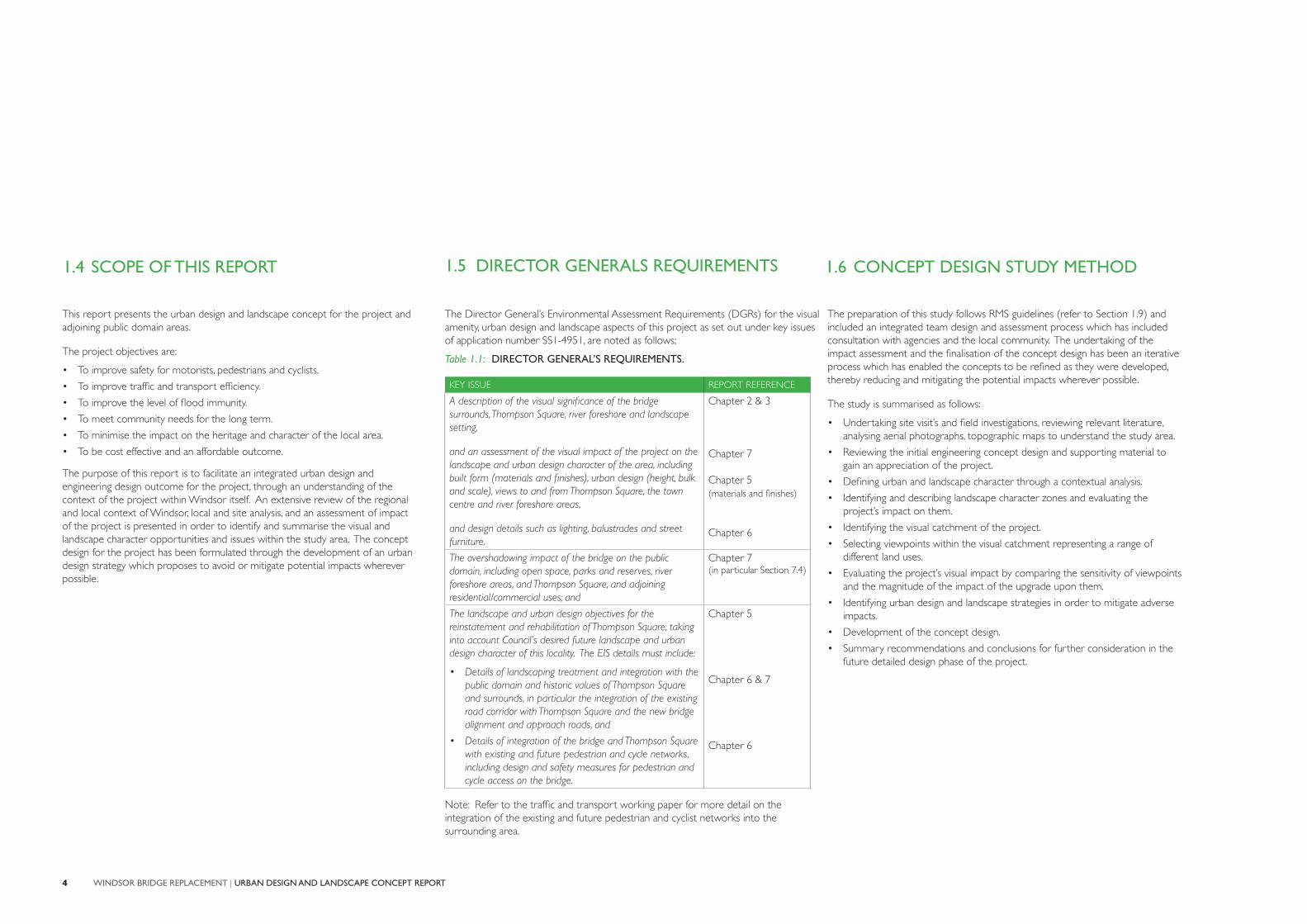
1.5 DIRECTOR GENERALS REQUIREMENTS
The Director General’s Environmental Assessment Requirements (DGRs) for the visual amenity, urban design and landscape aspects of this project as set out under key issues of application number SS1-4951, are noted as follows;
Table 1.1: DIRECTOR GENERAL’S REQUIREMENTS.
KEY ISSUE REPORT REFERENCE
A description of the visual significance of the bridge surrounds, Thompson Square, river foreshore and landscape setting,
and an assessment of the visual impact of the project on the landscape and urban design character of the area, including built form (materials and finishes), urban design (height, bulk and scale), views to and from Thompson Square, the town centre and river foreshore areas,
and design details such as lighting, balustrades and street furniture.
Chapter 2 & 3
Chapter 7
Chapter 5(materials and finishes)
Chapter 6
The overshadowing impact of the bridge on the public domain, including open space, parks and reserves, river foreshore areas, and Thompson Square, and adjoining residential/commercial uses; and
Chapter 7(in particular Section 7.4)
The landscape and urban design objectives for the reinstatement and rehabilitation of Thompson Square, taking into account Council’s desired future landscape and urban design character of this locality. The EIS details must include:
• Details of landscaping treatment and integration with the public domain and historic values of Thompson Square and surrounds, in particular the integration of the existing road corridor with Thompson Square and the new bridge alignment and approach roads, and
• Details of integration of the bridge and Thompson Square with existing and future pedestrian and cycle networks, including design and safety measures for pedestrian and cycle access on the bridge.
Chapter 5
Chapter 6 & 7
Chapter 6
Note: Refer to the traffic and transport working paper for more detail on the integration of the existing and future pedestrian and cyclist networks into the surrounding area.
1.6 CONCEPT DESIGN STUDY METHOD
This report presents the urban design and landscape concept for the project and adjoining public domain areas.
The project objectives are:
• To improve safety for motorists, pedestrians and cyclists.
• To improve traffic and transport efficiency.
• To improve the level of flood immunity.
• To meet community needs for the long term.
• To minimise the impact on the heritage and character of the local area.
• To be cost effective and an affordable outcome.
The purpose of this report is to facilitate an integrated urban design and engineering design outcome for the project, through an understanding of the context of the project within Windsor itself. An extensive review of the regional and local context of Windsor, local and site analysis, and an assessment of impact of the project is presented in order to identify and summarise the visual and landscape character opportunities and issues within the study area. The concept design for the project has been formulated through the development of an urban design strategy which proposes to avoid or mitigate potential impacts wherever possible.

5INTRODUCTION
This report is structured as follows:
• Chapter 1: Introduction - introduces the project and outlines the scope and study team.
• Chapter 2: The Existing Context of Windsor - a description and illustration of the environmental and cultural factors of the local area.
• Chapter 3: Significance of Place - a description and analysis of the study area including opportunities and constraints.
• Chapter 4: The Project - a summary of the key engineering works.
• Chapter 5: Urban Design, Bridge and Landscape Strategy - urban design objectives and principles, along with bridge design and the design of urban and landscape elements.
• Chapter 6: Urban Design, Bridge and Landscape Concept - illustration of the concept design in graphic format including plans, cross sections and details.
• Chapter 7: Assessment of Impact - landscape character and visual impact assessment including a summary of mitigation measures undertaken and further mitigation measures which are to be undertaken in the future.
• Chapter 8: Conclusions and Recommendations - a summary including agreed team decisions in the design process and next steps.
1.7 STUDY TEAM 1.8 REPORT STRUCTURE
The study team for this project comprised an integrated team of consultants in association with the RMS including:
• Client: Roads and Maritime Services (RMS) including the disciplines of engineering, environmental assessment, heritage and urban design.
• Engineering, biodiversity and noise assessment: Sinclair Knight Merz (SKM) including road design, bridge design and environmental assessment.
• Urban design and landscape and visual assessment: Spackman Mossop Michaels (SMM).
• Bridge architecture: Hill Thalis (HT).
• Heritage: Biosis Research Pty Ltd.
• Aboriginal Heritage: Kelleher Nightingale Consulting Pty Ltd.
• Maritime Archaeology: Cosmos Archaeology.
1.9 RMS GUIDELINE DOCUMENTS
RMS have produced a comprehensive list of design guideline documents aimed at achieving good urban design outcomes. This report has been undertaken with reference to the following published documents:
• Beyond the Pavement (RMS, 2009).
• Landscape Guideline (RMS, 2008).
• Bridge Aesthetics (RMS, 2004).
• Environmental Impact Assessment Guidance Note, Guidelines for Landscape Character and Visual Impact Assessment (RMS, 2008).
Environmental Impact Assessment Guidance Note Guidelines for landscape character and visual impact assessment EIA-N04
WINDSOR BRIDGE REPLACEMENT | URBAN DESIGN AND LANDSCAPE CONCEPT REPORT
1.10 STRATEGIC POLICY CONTEXT
The desired future character of the study area is drawn from an analysis of the existing character of the foreshore areas of Windsor that comprise the study area, and consideration of the strategic planning documents relevant to the project. These include:
• Draft North West Sub-regional Strategy 2007.
• Hawkesbury Community Strategic Plan 2010-2030.
• Hawkesbury Residential Lands Strategy.
• Hawkesbury Local Environmental Plan 1989.
• Hawkesbury City Council Generic Plans of Management for Community Lands.
• Plan of Management for the Windsor Foreshore Parks - Incorporating the Great River Walk.
Appendix B provides a more detailed consideration of each document and the relevance of objectives and key actions to the project.
The Plan of Management for the Windsor Foreshore Parks is of particular relevance and identifies the following vision statement:
“Creating and managing a foreshore open space corridor in Windsor that provides a valuable resource for recreation, cultural engagement and identity to the community both local and metropolitan, and that pursues sustainable best practice environmental management that contributes to the health of the broader river catchment system.”
These desired improvements to the foreshore corridor, cultural engagement and river health, as well as improvements to vehicular, cyclist and pedestrian access within and through Windsor identified in other strategic planning documents, designed in a way that is sympathetic to existing valued heritage and cultural qualities and characteristics, form the desired character of the study area.