upper rio grande basin: finding flexibility in federal
TRANSCRIPT
University of New Mexico University of New Mexico
UNM Digital Repository UNM Digital Repository
Law of the Rio Chama The Utton Transboundary Resources Center
2001
Upper Rio Grande Basin: Finding Flexibility in Federal Reservoir Upper Rio Grande Basin: Finding Flexibility in Federal Reservoir
System Operations Within the Web of Water Laws, Policies, and System Operations Within the Web of Water Laws, Policies, and
Institutions Institutions
Gail Stockton
William DeRagon
Lisa Robert
Follow this and additional works at: https://digitalrepository.unm.edu/uc_rio_chama
Recommended Citation Recommended Citation Stockton, Gail; William DeRagon; and Lisa Robert. "Upper Rio Grande Basin: Finding Flexibility in Federal Reservoir System Operations Within the Web of Water Laws, Policies, and Institutions." (2001). https://digitalrepository.unm.edu/uc_rio_chama/34
This Article is brought to you for free and open access by the The Utton Transboundary Resources Center at UNM Digital Repository. It has been accepted for inclusion in Law of the Rio Chama by an authorized administrator of UNM Digital Repository. For more information, please contact [email protected], [email protected], [email protected].
Upper Rio Grande Basin: Finding Flexibility in Federal Reservoir System Operations
Within the Web of Water Laws, Policies, and Institutions
Gail Stockton *, William DeRagon **, Lisa Robert ***�
*U.S. Army Corps of Engineers, Albuquerque District, 4101 Jefferson Plaza, NE, Albuquerque, NM 87109; PH (505) 342-3348; Fax (505) 343-3195; email:[email protected] **U.S. Army Corps of Engineers, Albuquerque District, 4101 Jefferson Plaza, NE, Albuquerque, NM; PH (505) 342-3358; Fax (505) 342-3668; email:[email protected] ***Upper Rio Grande Basin Water Operations Review and EIS Steering Committee, 35 Miguel Road, Los Lunas, NM 87031; PH (505) 865-1455, Fax (505) 865-1455; email:[email protected] Abstract. An intricate structure of water laws, policies and institutions in the upper Rio Grande basin provides the framework for operation of nearly a dozen federal reservoirs and related projects by the U.S. Army Corps of Engineers and the Bureau of Reclamation. These two agencies are responsible, respectively, for controlling and safely passing flood flows, and for storing and releasing water for agricultural, municipal / industrial use and other uses. The institutions encountered or affected by the Rio Grande as it flows from its headwaters in Colorado to Fort Quitman, Texas, include two countries, three states, 20 Pueblos and Tribes, two rapidly growing major metropolitan areas, 21 counties, as many local governments and a myriad of acequias and irrigation districts. Associated directly with storing and releasing river water in the upper Rio Grande basin are an international treaty with Mexico, an interstate compact among Colorado, New Mexico and Texas, more than a dozen federal water project authorizations, water laws, and state and tribal water quality standards. Adding to this tangle are about three dozen or so other federal authorities to restore and protect the natural environment, preserve and protect historic and cultural resources, and to protect the rights of Native Americans. Through ongoing collaborative and cooperative efforts, including the Upper Rio Grande Water Operations Model, the Upper Rio Grande Basin Water Operations Review, and others, some flexibilities in operation are being identified, providing a critical step in developing water management solutions. Introduction The area addressed in this discussion is the upper Rio Grande basin (Figure 1.) from the river’s headwaters in southwestern Colorado to Fort Quitman, Texas. The Continental Divide forms the basin’s western boundary, while the Sangre de Cristo Mountains and a nearly continuous series of smaller north-south ranges form the eastern boundary. A portion of the basin lies in Mexico. A highly variable stream flow regime driven by a semi-arid climate contributes to the complexity of water management in the basin. Available surface water includes natural flow of the Rio Grande
Copyright ASCE 2004 World Water Congress 2001 Bridging the Gap
Dow
nloa
ded
from
asc
elib
rary
.org
by
Col
in M
cKen
zie
on 1
1/09
/17.
Cop
yrig
ht A
SCE
. For
per
sona
l use
onl
y; a
ll ri
ghts
res
erve
d.
and its tributaries, and a trans-basin diversion called the San Juan-Chama Project, which imports water from tributaries of the Colorado River basin. Smaller sources of Rio Grande discharge include groundwater salvage in the San Luis Valley, Colorado, a few trans-basin ditches in Colorado, and municipal wastewater. Spring snowmelt runoff produces the majority of the basin’s surface water and usually begins in March and continues through June and, perhaps, July. During summer months, precipitation from thunderstorms can be a significant contributor to stream flow; many of the Rio Grande’s tributaries flow only in response to these events. Above Fort Quitman the Rio Grande is about 1100 kilometers (700 miles) long and drains an area of approximately 78,000 square kilometers (30,000 square miles). Rio Grande tributaries with drainage areas greater than 1300 square kilometers (500 square miles) are the Conejos River, Rio Chama, Galisteo Creek, Jemez River, Rio Puerco, and Rio Salado.
The basin has a population of over 2.5 million, and is characterized by high unemployment and a per capita income below the national average, but with rapid growth in the urban areas. Municipal and industrial water demands are growing steadily, as a result of increased urbanization. Rio Grande, the Resource. To many people, the Rio Grande is more than merely water or trees or wildlife, and is more than the sum of individual resources or monetary values. It has been described as “a ribbon of life”, and “a way of life,” and is eloquently put in perspective by Native Americans like a gentleman from the Pueblo of San Felipe who said, “ It sustains our soul and cleanses our spirit.” He was taught to visit the river to “promote its journey downstream,” and recalls his father taking him there in hopes he would become like the Rio Grande, “placid, yet full of energy.”
The Rio Grande has been a focus of human occupation for thousands of years. Over 5,000 historic properties and archaeological sites have been identified on less than 20 percent of the area adjacent to the river. The river and its surrounding landscape are central to the cultural identity of the basin’s diverse communities and changes to the flow regime have the potential to dramatically affect historic resources and traditional practices that are important to not only all who live along the Rio Grande, but to the rest of the nation as well.
The river’s aquatic habitat has deteriorated due to water resource and physical changes of the river and its floodplain. These changes include increased water diversions, flood control, sediment control, discharge management, urban development, invasion of nonnative plants, and reduced healthy riparian-riverine interaction. Reservoir aquatic habitat is subjected to frequent changes in pool elevation, limiting the ability of aquatic species to effectively use available habitat. Recent aquatic habitat studies have focused primarily on the endangered Rio Grande silvery minnow and indicate that unless significant changes are made, the species could disappear from the Rio Grande system in the near future.
The riparian zone of a river is the area next to the channel where vegetation may be influenced by water tables or flooding. Historically, riparian vegetation along the middle Rio Grande consisted of scattered, mixed stands of cottonwood trees, willow shrubs, and salt grass meadows. Where groundwater was close to the surface, ponds, marshes and shrub wetlands also occurred. The extent and character of bosque (river forest) and wetland communities have dramatically changed over the past hundred years due to urban, agricultural, and water resource development, and the spread of exotic species such as Russian olive and salt cedar (Figure 2.). In addition to its regionally unique and valuable wildlife habitat, the riparian community
Copyright ASCE 2004 World Water Congress 2001 Bridging the Gap
Dow
nloa
ded
from
asc
elib
rary
.org
by
Col
in M
cKen
zie
on 1
1/09
/17.
Cop
yrig
ht A
SCE
. For
per
sona
l use
onl
y; a
ll ri
ghts
res
erve
d.
functions to stabilize banks, attenuate flood flows, and remove and trap water-borne sediment and nutrients.
Operation of federal flood control and water delivery facilities has altered the hydrology and geomorphology (land forms) of the upper Rio Grande basin by reducing peak flows and the amount of sediment delivered downstream. Peak floods and sediment maintain a river channel, sustain riparian communities, and provide aquatic habitat for fish and other wildlife. Changes in river channel morphology, sediment delivery, bed material composition, and interaction between the river and the floodplain have occurred, in part, due to the operation of federal facilities. Federal flood control facilities have decreased peak discharge, sediment load, bank erosion, and flood damage in various reaches. Sustaining a more complex and dynamic channel morphology, while providing adequate flood protection and water delivery, is key to the successful future operation of federal flood and water delivery facilities.
Surface water quality in the Rio Grande and its tributaries is variable both in location and time. It is affected by complex interactions between natural factors such as climate and hydrogeologic setting, and by human influences such as land use and water operations. Due to the dynamic interaction between water quality and river flow, changes in current water operations could affect surface water quality. Agricultural production is highly dependent on irrigation and varies significantly throughout the region. Crops range from potatoes, barley, and wheat in Colorado, to alfalfa and pasture in the middle Rio Grande, and cotton, pecans, and chile in the lower part of the basin. What may not be clear from inventory of crops, however, is the fact that farming, particularly in New Mexico, is often subsistence based, and remains an intrinsic part of the traditional cultures of the Rio Grande.
The Rio Grande is home to many public recreation facilities including state parks, Wild and Scenic River areas, tribal recreation areas, national monuments and national wildlife refuges, and federal reservoir recreation areas. These facilities provide the majority of the water-based recreation for the basin, including boating, fishing, swimming, skiing, windsurfing, and white water rafting, while the river and its adjacent lands provide opportunities for fishing, kayaking, bird watching, bicycling, hiking, horseback riding, picnicking, playgrounds, hunting, camping and sightseeing. Institutional Background
The basin’s water management infrastructure and its institutional framework are closely related. They have developed together over time and can, perhaps, best be described and understood in terms of their historical development. The Rio Grande and most of its major tributaries are controlled by dam and reservoir systems, diversion structures, and artificial channels of various kinds. Nine main reservoirs and many small ones regulate floods and store water for irrigation, municipal and industrial uses, recreation, and fish and wildlife habitat. Diversion structures and conveyance facilities deliver water to users throughout the basin.
Waters of the Rio Grande and the various supplemental sources are allocated among users by a complex system of international treaty, interstate compact, state and federal laws, interbasin delivery contracts, water rights, and established flow regulation criteria. Other laws and policies mandate environmental and cultural resource protection. The National Environmental Policy Act
Copyright ASCE 2004 World Water Congress 2001 Bridging the Gap
Dow
nloa
ded
from
asc
elib
rary
.org
by
Col
in M
cKen
zie
on 1
1/09
/17.
Cop
yrig
ht A
SCE
. For
per
sona
l use
onl
y; a
ll ri
ghts
res
erve
d.
also sets planning and decision-making requirements for all actions performed, funded, or permitted by federal agencies. This system of laws and rules governs operation of the basin’s reservoirs and other infrastructure systems. Accounting systems are in place to keep track of water supplies, reservoir storage, deliveries, depletions, etc.
Irrigation in the basin by Native Americans predated European settlement. Neither they, nor the early Spanish colonists substantially altered the river’s flow. Instead, acequias (community ditches) were adequate to serve local needs. International Treaty. By the 1880’s, however, increased diversions in the San Luis Valley of Colorado resulted in shortages downstream, particularly in the Mesilla Valley in New Mexico and in the El Paso/Cuidad Juarez area at the Texas border with Mexico. In 1896, responding to pleas from downstream irrigators, the United States government ordered an embargo on additional irrigation development pending negotiation of a treaty with the Republic of Mexico. A convention was signed in 1906 under which Mexico is annually allocated “60,000 acre-feet” of water from the Rio Grande. Elephant Butte Dam, an early Bureau of Reclamation project, was completed in 1916 to provide a dependable water supply to meet this obligation and for irrigation in the Mesilla Valley and El Paso areas. In 1939, Caballo Dam was completed downstream from Elephant Butte to supplement storage, provide flood control, and permit year round power generation at Elephant Butte Dam during years of normal water supply. Consolidated Irrigation District. By the early years of this century the effects of poor drainage, flooding, and sedimentation in the middle valley between Cochiti Pueblo and Elephant Butte had resulted in waterlogged lands, decreased irrigated acreage and declining agricultural production. Albuquerque businessmen organized the Middle Rio Grande Conservancy District (MRGCD) in the mid-1920s to address these problems and stabilize the local economy. In addition to drainage, flood control, and improved irrigation works, the MRGCD built El Vado Dam (completed in 1935) on the Rio Chama to store water for irrigation in the middle valley. Rio Grande Compact. In 1938, after years of negotiation, the states of Colorado, New Mexico, and Texas signed the Rio Grande Compact, one of the legal cornerstones governing operation of the river and its reservoirs above Caballo Dam. Administered by a commission of delegates from the three states and one nonvoting federal representative, the compact apportions the Rio Grande’s waters among the three states according to a specified annual delivery schedule that depends on the flow at designated index stations. Colorado is prohibited from accruing a debit, or under-delivery to the downstream states, of more than “100,000 acre-feet”, while New Mexico’s accrued debit to Texas is limited to “200,000 acre-feet.” Any deviation from the terms of the Compact requires unanimous approval from the three state commissioners.
In the 1930s and 1940s it became apparent that the MRGCD and other local and state agencies needed federal assistance to deal with problems of poor drainage, flooding, and deterioration of the irrigation system in the middle valley. In addition, New Mexico began to fall behind in making deliveries to Elephant Butte Reservoir as required by the compact. In response to requests for federal assistance and under authority of the Flood Control Act of 1941, the Corps of Engineers and Bureau of Reclamation cooperatively developed a comprehensive plan to construct the Middle Rio Grande Project. The Comprehensive Plan, completed in 1947, was authorized by Congress in the Flood Control Acts of 1948 and 1950. Under these authorizations,
Copyright ASCE 2004 World Water Congress 2001 Bridging the Gap
Dow
nloa
ded
from
asc
elib
rary
.org
by
Col
in M
cKen
zie
on 1
1/09
/17.
Cop
yrig
ht A
SCE
. For
per
sona
l use
onl
y; a
ll ri
ghts
res
erve
d.
the Corps constructed Jemez Canyon and Abiquiu Dams, and Reclamation built the Low Flow Conveyance Channel, various river stabilization works, and rehabilitated the MRGCD’s irrigation and drainage system under these authorizations. Reclamation completed Platoro Dam in 1951 as a part of the San Luis Valley Project to provide storage of irrigation water for the Conejos Water Conservancy District in Colorado.
In 1960, Congress authorized Cochiti and Galisteo Dams to provide flood and sediment control in the middle valley. A recreation pool at Cochiti Dam was later authorized in 1964 to be supplied with water from the San Juan-Chama Project, and the Corps built both dams in 1975.
The San Juan-Chama Project was authorized in 1963 to supplement the water supply for the city of Albuquerque, the MRGCD and other middle valley users and to enable New Mexico to fully use its allocation of Upper Colorado River Basin water. The project, completed in 1971 is operated and maintained by the Bureau of Reclamation. It consists of three diversion dams, three tunnels through the Continental Divide, Heron Dam and Reservoir, modifications to El Vado Dam to accommodate San Juan-Chama water.
The Closed Basin Project, constructed in the 1970s and 1980s, is a water salvage project in the San Luis Valley of Colorado, consisting of water salvage wells, a network of pipelines, a conveyance channel to the Rio Grande, and monitoring wells. Specific Water Operations Authorities. The U.S. Bureau of Reclamation, Albuquerque Area Office (Reclamation) and the U.S. Army Corps of Engineers, Albuquerque District (Corps), are the two major federal entities that affect water and river management in the basin. River management actions take place under the specific authority of the following laws and more generally under a host of others.
Corps. The Corps operates reservoir facilities for flood and sediment control in the Upper Rio Grande Basin under existing authority of: � P.L. 86-645 (1960) authorized construction of Cochiti and Galisteo Dams and provides
very specific operating criteria that limits the reservoirs to minimal regulation of flood waters. The stipulation for carry-over storage authorizes storage of native Rio Grande water in these reservoirs. The rate at which each reservoir is evacuated during spring snowmelt runoff is restricted to the downstream channel capacity, as determined by the Corps. P.L. 88-293 (1964) authorizes a permanent pool in Cochiti Lake for recreation and fish and wildlife; the pool was established and maintained with San Juan-Chama Project water.
� P.L. 97-140 (1981) authorizes “up to 200,000 acre-feet” of contract storage of San Juan Chama project water in Abiquiu Reservoir with certain conditions.
� P.L. 100-522 (1988) authorizes storage of Rio Grande system water “up to 200,000 acre-feet” in Abiquiu Reservoir in the San Juan-Chama storage space, if the San Juan-Chama entities no longer require such storage; the storage of Rio Grande system water is subject to the provisions of the Rio Grande Compact.
� Flood Control Act of 1944 (58 Stat. 890, 33 U.S.C. 709), Section 7, Flood Control Regulation for Platoro Reservoir, Conejos River, Colorado is the responsibility of the Corps.
Copyright ASCE 2004 World Water Congress 2001 Bridging the Gap
Dow
nloa
ded
from
asc
elib
rary
.org
by
Col
in M
cKen
zie
on 1
1/09
/17.
Cop
yrig
ht A
SCE
. For
per
sona
l use
onl
y; a
ll ri
ghts
res
erve
d.
Reclamation. The Bureau of Reclamation operates reservoir and channel facilities in the Upper Rio Grande basin under the authorities of: � The Flood Control Acts of 1948 (P.L. 80-858) and 1950 authorized construction, operation,
and maintenance of channel rectification works of the Middle Rio Grande Project, which includes the Low Flow Conveyance Channel.
� P.L. 87-483 (1962) authorizes the San Juan-Chama Project, which makes possible diversion of water from the upper tributaries of the San Juan River through the Continental Divide and into the Rio Grande drainage, not to exceed a maximum of “270,000 acre-feet” in any one year, and limited to a “total of 1,350,000 acre-feet” in any consecutive ten-year period. The authorization allows municipal, irrigation, domestic, and industrial uses, and provides recreation and fish and wildlife benefits. Reclamation administers the contracts for San Juan-Chama Project water. Heron Reservoir is a facility of the San Juan-Chama Project and stores only water diverted from the San Juan Basin.
� P.L. 92-514 (1972) authorizes the Closed Basin project in Colorado to salvage groundwater that would otherwise be lost to evapotranspiration. The project helps the state of Colorado meet its required compact deliveries to New Mexico and to help all three Compact states meet their delivery requirements to the Republic of Mexico.
� P.L. 93-493 (1974) authorizes a recreation pool at Elephant Butte of “50,000 acre-feet.” The state of New Mexico has contracted with the city of Albuquerque for San Juan-Chama project water to maintain the recreation pool since 1985.
Other Parts of the Institutional Web. In addition to Reclamation and the Corps, the
decisions and actions of a wide range of other interests affect the flow of the Rio Grande. Other federal agencies whose responsibilities affect water management include the Bureau of Indian affairs (BIA), the Bureau of Land Management, the National Park Service, the U.S. Environmental Protection Agency (EPA), and the U.S. Fish and Wildlife Service.
Native American governments also have key interests in the Rio Grande and make management decisions that influence federal water management. Irrigation service to farmland on six pueblos is provided by the Middle Rio Grande Conservancy District (MRGCD), as mandated by federal law and represented in contracts between the MRGCD and the BIA. Reclamation and the Corps stand in trustee relationship to Indian tribes and Pueblos, including those along the Rio Grande. Several Pueblos have established EPA-approved river water quality standards. Additionally, Pueblos have their own programs to manage the bosque (riparian woodland) within their boundaries. Two flood control reservoirs, Cochiti and Jemez Canyon, are located on Pueblo lands, and are managed in strict compliance with agreements with the respective Pueblos. New Mexico, Texas, and Colorado all have agencies that deal with various aspects of water management such as issuing water right permits, managing interstate stream deliveries, species and habitat conservation, and water quality regulation. Additional jurisdictions include twenty-one counties, three regional flood control authorities, five major irrigation districts, hundreds of acequias, several large cities, and countless towns and villages.
Since the 1960’s, increasing public concern for environmental values has resulted in more stringent laws requiring environmental protection, endangered species preservation, and public participation in decision-making processes. Federal actions must also consider many other laws and regulations that apply to wilderness areas, cultural preservation, antiquities,
Copyright ASCE 2004 World Water Congress 2001 Bridging the Gap
Dow
nloa
ded
from
asc
elib
rary
.org
by
Col
in M
cKen
zie
on 1
1/09
/17.
Cop
yrig
ht A
SCE
. For
per
sona
l use
onl
y; a
ll ri
ghts
res
erve
d.
recreation, clean water, fish and wildlife, flood plain management, wild and scenic rivers, tribal laws and regulations, protection of wetlands and many others. The effect of these laws on river and reservoir operations has significantly increased the complexity of day-to-day operations. Web as Framework for Cooperation. Since river management is such a complex undertaking involving hydrological, legal, and biological considerations, it can only benefit from cooperative efforts. The following are but a few of these efforts. A Tool for Enhanced System Management. The Upper Rio Grande Water Operations Model (URGWOM) is currently being developed and tested. This major cooperative effort between a multitude of water management agencies and other interests is focused on developing a decision-making tool that can be used to address contemporary needs, including ecosystem health, and provide for enhanced system management. The model represents the physical, accounting, and operational complexities of river and reservoir management and should improve the availability, timeliness, completeness and accuracy of data for water storage, deliveries, depletions, flood control operations, and other management decisions. It is being developed for both daily water operations and comprehensive planning.
URGWOM is a daily time-step water operations model utilizing a numerical computer modeling software called RiverWare™. Current development simulates water storage and delivery operations from the New Mexico-Colorado state line to Elephant Butte Reservoir in New Mexico and flood control operations from Elephant Butte Dam to the American Dam in El Paso, Texas.
URGWOM is composed of four distinct models. The accounting model represents the complete physical stream system and is designed to solve for reservoir inflows, given outflows, water elevations, weather and other reservoir data. It deals strictly with the past, calculating all flows and storages through midnight of the previous day. The water operations model is the forecasting version of the accounting model. It uses updated historic data from the accounting model; along with other short term forecast data to predict flows and storages for the future. It uses rules, as needed, to determine outflows. The forecasting model takes monthly spring runoff forecasts and uses historic inflow hydrographs (volume of water over time) to create daily forecast hydrographs for each of the inflow points in the water operations model. The planning model is designed to carry out long-term forecasts using less detailed data and rules. Further history, background, and status can be found at the URGWOM website: http://www.spa.usace.army.mil/urgwom Review of Federal Reservoir Operations. As evidenced by the web of infrastucture outlined above, a change in operations at one location can have upstream and downstream affects. With the availability of URGWOM, it will be possible to evaluate reservoir operation in the upper Rio Grande basin as a whole. The Corps, the Bureau of Reclamation, and the New Mexico Interstate Stream Commission have partnered to develop an integrated plan for water operations at federal reservoirs in the upper Rio Grande basin using URGWOM as the tool. In addition to theses joint lead agencies are potentially another dozen cooperating agencies who are
Copyright ASCE 2004 World Water Congress 2001 Bridging the Gap
Dow
nloa
ded
from
asc
elib
rary
.org
by
Col
in M
cKen
zie
on 1
1/09
/17.
Cop
yrig
ht A
SCE
. For
per
sona
l use
onl
y; a
ll ri
ghts
res
erve
d.
examining what they can do under existing authorities to improve how water is stored and delivered.
This study, called the Upper Rio Grande Basin Water Operations Review, officially began with the publication of a Notice of Intent to Prepare an Environmental Impact Statement in the Federal Register on March 7, 2000. The Review will examine selected water operations activities in the Rio Grande basin above Fort Quitman, Texas, that are within the joint lead agencies’ existing authorities. The major responsibilities of the Corps and Reclamation have been described earlier. The New Mexico Interstate Stream Commission monitors compact deliveries and San Juan-Chama project water storage and releases.
There Review will coordinate with other cooperative and collaborative efforts already in progress in the basin. A few that have targeted specific Rio Grande resources for evaluation and improvement are the Endangered Species Act Work Group, the Rio Grande Silvery Minnow Recovery Team, the Bosque Hydrology Group, the Paseo del Norte Watershed Council, and the ET (evapotranspiration) Work Group.
The Review will determine how the lead agencies will use their existing water operations authorities to: • Help meet water needs of all users, including the need for conservation of endangered
species. • Meet downstream delivery requirements mandated by the Rio Grande Compact and the
international treaty with Mexico. • Provide flood protection and sediment control. • Assure safe dam operations. • Support compliance with local, state, tribal, and federal water quality regulations. • Identify flexibility for operation of federal reservoirs and facilities within existing
authorities. • Assist managing agencies to operate these facilities more efficiently as an integrated system. • Improve decision-making processes on water operations through better interagency
communications and more public input. • Support future compliance by the joint lead agencies with the National Environmental Policy
Act, the Endangered Species Act, and all other applicable laws and regulations. Further information and status may be found at the project web site: http://www.spa.usace.army.mil/urgwops/ References: New Mexico Interstate Stream Commission, U.S. Bureau of Reclamation, U.S. Army Corps of
Engineers, Memorandum of Agreement Upper Rio Grande Basin Water Operations, Santa Fe, New Mexico, January, 2000.
New Mexico Water Resources Research Institute, Proceedings of the 39th Annual New Mexico Water Conference, The Water Future of Albuquerque and the Rio Grande Basin,
November 3-4, 1994, “History of Water Development in the Middle Valley” presentation by Gary Daves, Albuquerque Convention Center, May 1995, Las Cruces, NM.
U.S. Army Corps of Engineers, US Bureau of Reclamation, U.S. Bureau of Indian Affairs, U.S. Geological Survey, U.S. Section of the International Boundary and Water Commission,
Copyright ASCE 2004 World Water Congress 2001 Bridging the Gap
Dow
nloa
ded
from
asc
elib
rary
.org
by
Col
in M
cKen
zie
on 1
1/09
/17.
Cop
yrig
ht A
SCE
. For
per
sona
l use
onl
y; a
ll ri
ghts
res
erve
d.
Memorandum of Understanding for Development of an Upper Rio Grande Water Operations Model for Enhanced System Management, Albuquerque, NM, 1996. U.S. Army Corps of Engineers, U.S. Bureau of Indian Affairs, U.S. Bureau of Reclamation, U.S.
Fish and Wildlife Service, U.S. Geological Survey, US Section of the International Boundary and Water Commission, Upper Rio Grande Water Operations Model Plan For Development, Albuquerque, NM, February, 1997.
U.S. Army Corps of Engineers, U.S. Bureau of Reclamation, Programmatic Biological Assessment
of Federal Discretionary Actions Related to Water Management on the Middle Rio Grande,
New Mexico, Albuquerque, New Mexico, October, 1999.
Copyright ASCE 2004 World Water Congress 2001 Bridging the Gap
Dow
nloa
ded
from
asc
elib
rary
.org
by
Col
in M
cKen
zie
on 1
1/09
/17.
Cop
yrig
ht A
SCE
. For
per
sona
l use
onl
y; a
ll ri
ghts
res
erve
d.
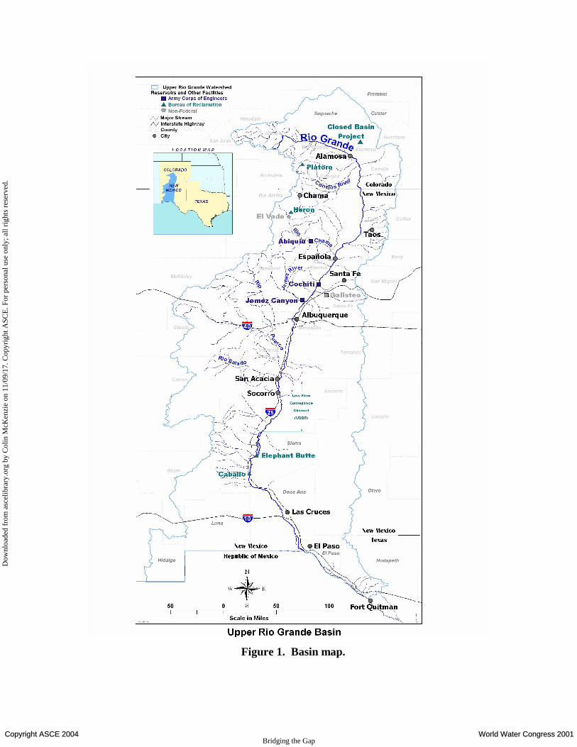
Figure 1. Basin map.
Copyright ASCE 2004 World Water Congress 2001 Bridging the Gap
Dow
nloa
ded
from
asc
elib
rary
.org
by
Col
in M
cKen
zie
on 1
1/09
/17.
Cop
yrig
ht A
SCE
. For
per
sona
l use
onl
y; a
ll ri
ghts
res
erve
d.
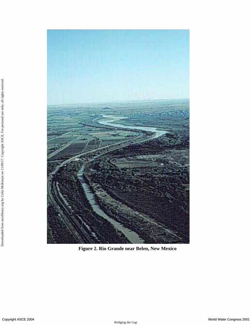
Figure 2. Rio Grande near Belen, New Mexico
Copyright ASCE 2004 World Water Congress 2001 Bridging the Gap
Dow
nloa
ded
from
asc
elib
rary
.org
by
Col
in M
cKen
zie
on 1
1/09
/17.
Cop
yrig
ht A
SCE
. For
per
sona
l use
onl
y; a
ll ri
ghts
res
erve
d.