ulloa channel to san christoval · pdf filebookletchart ulloa channel to . san christoval...
TRANSCRIPT

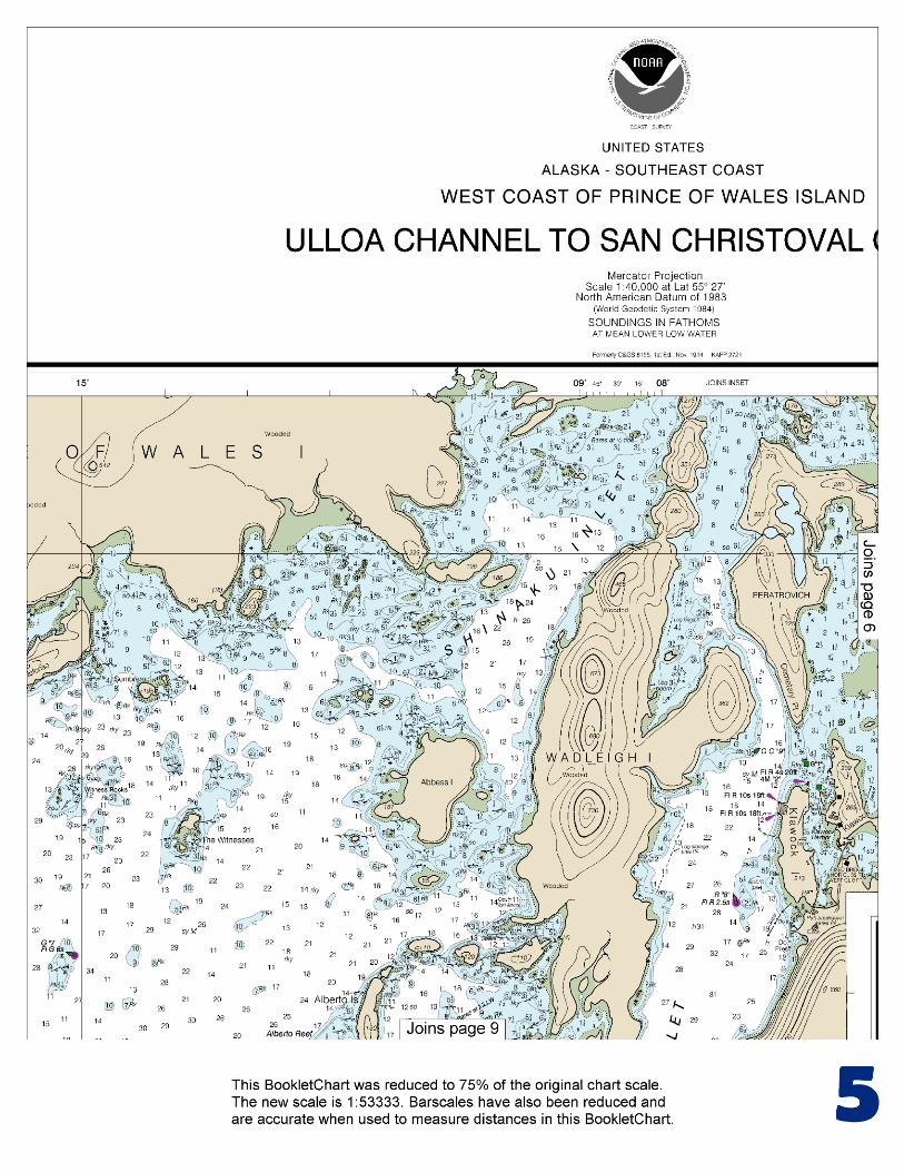
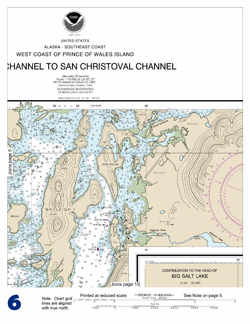
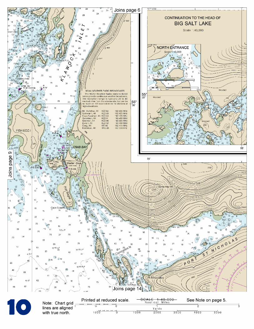
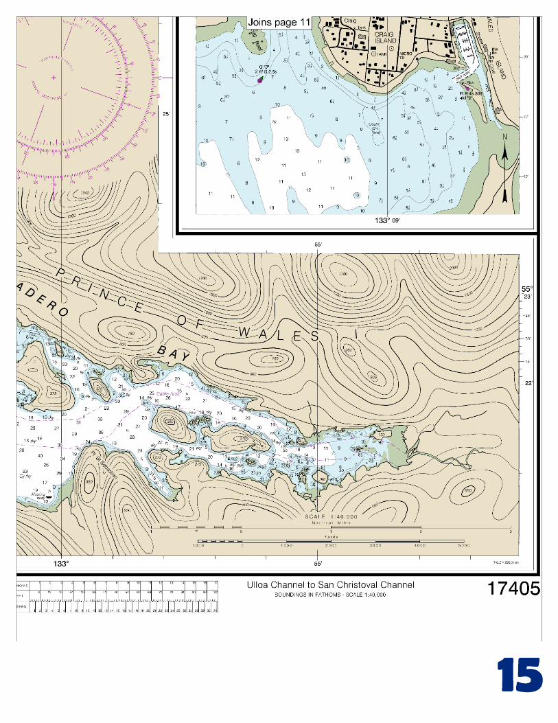
BookletChart™ Ulloa Channel to San Christoval Channel NOAA Chart 17405
A reduced-scale NOAA nautical chart for small boaters When possible, use the full-size NOAA chart for navigation.
Included Area

2
Published by the National Oceanic and Atmospheric Administration
National Ocean Service Office of Coast Survey
www.NauticalCharts.NOAA.gov 888-990-NOAA
What are Nautical Charts?
Nautical charts are a fundamental tool of marine navigation. They show water depths, obstructions, buoys, other aids to navigation, and much more. The information is shown in a way that promotes safe and efficient navigation. Chart carriage is mandatory on the commercial ships that carry America’s commerce. They are also used on every Navy and Coast Guard ship, fishing and passenger vessels, and are widely carried by recreational boaters.
What is a BookletChart?
This BookletChart is made to help recreational boaters locate themselves on the water. It has been reduced in scale for convenience, but otherwise contains all the information of the full-scale nautical chart. The bar scales have also been reduced, and are accurate when used to measure distances in this BookletChart. See the Note at the bottom of page 5 for the reduction in scale applied to this chart.
Whenever possible, use the official, full scale NOAA nautical chart for navigation. Nautical chart sales agents are listed on the Internet at http://www.NauticalCharts.NOAA.gov.
This BookletChart does NOT fulfill chart carriage requirements for regulated commercial vessels under Titles 33 and 44 of the Code of Federal Regulations.
Notice to Mariners Correction Status
This BookletChart has been updated for chart corrections published in the U.S. Coast Guard Local Notice to Mariners, the National Geospatial Intelligence Agency Weekly Notice to Mariners, and, where applicable, the Canadian Coast Guard Notice to Mariners. Additional chart corrections have been made by NOAA in advance of their publication in a Notice to Mariners. The last Notices to Mariners applied to this chart are listed in the Note at the bottom of page 7. Coast Pilot excerpts are not being corrected.
For latest Coast Pilot excerpt visit the Office of Coast Survey website at http://www.nauticalcharts.noaa.gov/nsd/searchbychart.php?chart=17405.
(Selected Excerpts from Coast Pilot) San Juan Bautista Island, in the N part of Bucareli Bay, has two prominent summits. The island separates Bucareli Bay from Ursua Channel to the NW and San Alberto Bay to the N. Agueda Point is at the NE end, and Diamond Point is at the SW end of the island. Deep-draft vessels passing W of San Juan Bautista Island should exercise caution in the area. Point Miliflores, bold and wooded, is the
SE point of San Juan Bautista Island. San Juanito Island, about 500 yards ENE of the point, is wooded and from N and S directions shows as a
prominent landmark clear of San Juan Bautista Island. Deep water extends close to the point and island. Port Estrella is S of San Juan Bautista Island and E of Cape Flores (55°21.2'N., 133°17.4'W.). Foul ground, marked at its outer end by a lighted buoy, extends N for about 0.3 mile from Cape Flores and about 0.2 mile S from Point Providence, the N point of the entrance. Anchor near the head of the bay in 7 to 9 fathoms. Caution is necessary on entering, as shoal water makes out from each side of the bay. Port Caldera, about 4.5 miles NE of Cape Flores and immediately E of Point Lomas, is open to the N. It affords limited anchorage with a 4 fathom shoal in the center of the bay. Foul ground extends about 300 yards off Point Iphigenia, the NE headland at the entrance. Trocadero Bay, E of the entrance to Port Caldera, extends about 9 miles E from the head of Bucareli Bay, with a greatest width of about 3 miles. The bay is locally known as Big Harbor. In the entrance is a group of islands, of which the largest is Madre de Dios Island. The islands have a few outlying rocks and the passages between them are mostly of good depth. The area to the S of Canoe Point between Canas Island and the larger island to the SE is foul with many rocks and broken ground. Passage to the head of Trocadero Bay should be made to the N of the group of islands E of Point St. Sebastian avoiding the small islet and dangerous rock 0.15 mile NW of the first large island. Near the head of Trocadero Bay, the chart is the guide. Dangers.–Craig Island Reef, marked by a lighted buoy, is a submerged rock with 1 fathom over it, about 0.6 mile NNE of the fish facility at Craig. A shoal, about 400 yards in extent with 1¼ fathoms over it, is about 400 yards W of Craig Island Reef. Fish Egg Reef extends from the SE point of Fish Egg Island for about 275 yards into the channel W of Craig Island. A lighted buoy is off the outer end. A shoal extends about 300 yards from the NW point of Craig Island, in a NNW direction, obstructing the channel W of the island. Another shoal extends in a N direction about 300 yards from the NE point of Craig Island. Both shoals are marked off their outer ends by a buoy. Currents.–It is reported that the flood current sets toward the wharf and the ebb current sets off the wharf. Harbor regulations.–The harbormaster controls the use of the community dock, grids, and floats. The harbormaster monitors VHF-FM channel 16 and can be contacted by telephone (907-826-3275) or FAX (907-826-3278). Dangers.–A reef extends S from Peratrovich Island into the entrance channel to Klawock Harbor. The S extremity of the reef is about 250 yards N of Klawock Harbor Entrance Light 2 and is marked by a daybeacon. A daybeacon about 175 yards SE of the light marks the W side of a rocky shoal on the E side of the harbor entrance channel. This daybeacon should be given a berth of not less than 35 yards. Pilotage, Klawock.–Pilotage, except for certain exempted vessels, is compulsory for all vessels navigating the inside waters of the State of Alaska. (See Pilotage, Alaska, indexed as such, chapter 3 for details.) Vessels en route Klawock meet the pilot boat about 1 mile NW of Cabras Islands, Bucareli Bay (55°22.0'N., 133°24.8'W.). The pilot boat, a tugboat, can be contacted by calling “KLAWOCK PILOT BOAT” on VHF-FM channels 16, 13, or 12. Quarantine, customs, immigration, and agricultural quarantine.–(See chapter 3, Vessel Arrival Inspections, and Appendix A for addresses.) Quarantine is enforced in accordance with regulations of the U.S. Public Health Service. (See Public Health Service, chapter 1.)
U.S. Coast Guard Rescue Coordination Center 24 hour Regional Contact for Emergencies
RCC Juneau Commander 17th CG District (907) 463-2000 Juneau, Alaska

G
NOAA’s navigation managers serve as ambassadors to the maritime community. They help identify navigational challenges facing professional and recreational mariners, and provide NOAA resources and information for safe navigation. For additional information, please visit nauticalcharts.noaa.gov/service/navmanagers
To make suggestions or ask questions online, go to nauticalcharts.noaa.gov/inquiry. To report a chart discrepancy, please use ocsdata.ncd.noaa.gov/idrs/discrepancy.aspx.
Lateral System As Seen Entering From Seaward on navigable waters except Western Rivers
PORT SIDE
ODD NUMBERED AIDS
GREEN LIGHT ONLY
FLASHING (2)
PREFERRED CHANNEL
NO NUMBERS – MAY BE LETTERED
PREFERRED CHANNEL TO
STARBOARD
TOPMOST BAND GREEN
PREFERRED CHANNEL
NO NUMBERS – MAY BE LETTERED
PREFERRED CHANNEL
TO PORT
TOPMOST BAND RED
STARBOARD SIDE
EVEN NUMBERED AIDS
RED LIGHT ONLY
FLASHING (2)
FLASHING FLASHING
OCCULTING GREEN LIGHT ONLY RED LIGHT ONLY OCCULTING QUICK FLASHING QUICK FLASHING
ISO COMPOSITE GROUP FLASHING (2+1) COMPOSITE GROUP FLASHING (2+1) ISO
"1"
Fl G 6s
G "9"
Fl G 4s
GR "A"
Fl (2+1) G 6s
RG "B"
Fl (2+1) R 6s
"2"
Fl R 6s
8
R "8"
Fl R 4s
LIGHT
G
C "1"
LIGHTED BUOY
G
"5"
GR
"U"
GR
C "S"
RG
N "C"
RG
"G"
LIGHT
6
R
N "6"
LIGHTED BUOY
R
"2
"
CAN DAYBEACON
CAN NUN NUN
DAYBEACON
For more information on aids to navigation, including those on Western Rivers, please consult the latest USCG Light List for your area.
These volumes are available online at http://www.navcen.uscg.gov
Navigation Managers Area of Responsibility
Northeast
Lt. Meghan McGovern
Northwest and
Pacific Islands
Crescent Moegling
Great Lakes Region
Tom Loeper
Chesapeake and
Delaware Bay
Steve Soherr
California
Jeff Ferguson
[email protected] Mid-Atlantic
Lt. Ryan Wartick
Alaska
Lt. Timothy M. Smith
Western Gulf Coast
Alan Bunn
Central Gulf Coast
Tim Osborn
[email protected] South Florida
Puerto Rico
U.S. Virgin Islands
Michael Henderson
Southeast
Kyle Ward
2
2 C U 5
1


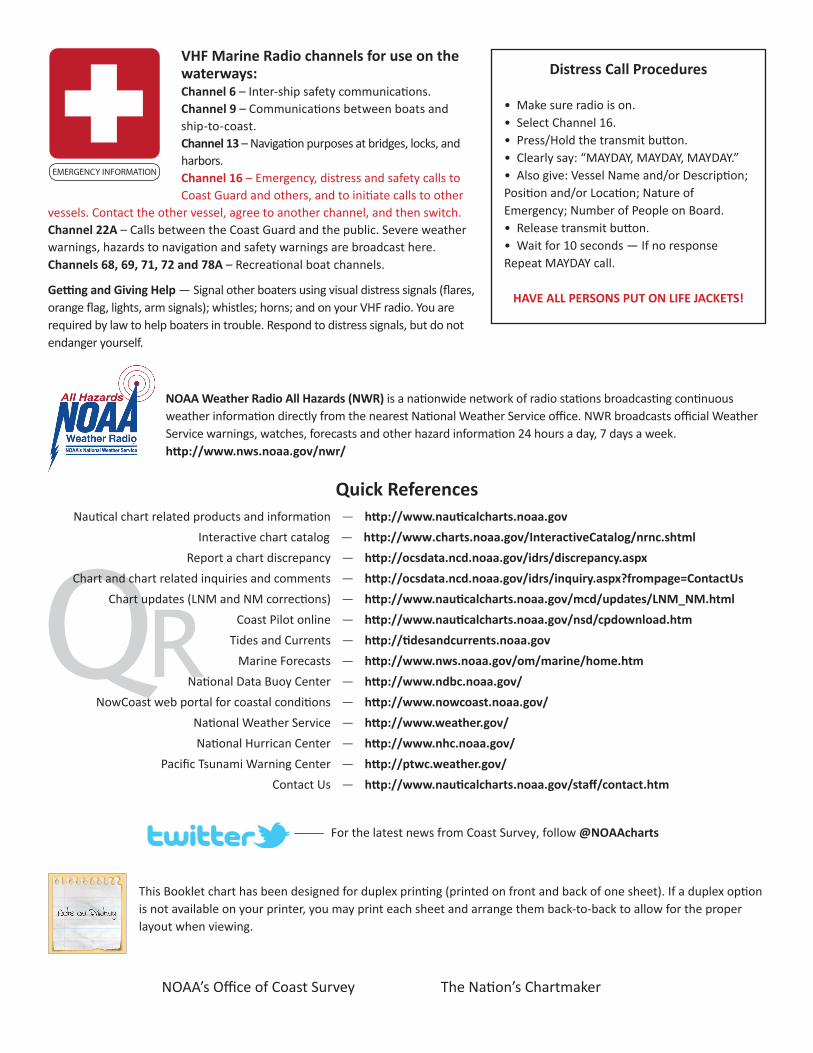
VHF Marine Radio channels for use on the waterways:Channel 6 – Inter-ship safety communications.Channel 9 – Communications between boats and ship-to-coast.Channel 13 – Navigation purposes at bridges, locks, and harbors.Channel 16 – Emergency, distress and safety calls to Coast Guard and others, and to initiate calls to other
vessels. Contact the other vessel, agree to another channel, and then switch.Channel 22A – Calls between the Coast Guard and the public. Severe weather warnings, hazards to navigation and safety warnings are broadcast here.Channels 68, 69, 71, 72 and 78A – Recreational boat channels.
Getting and Giving Help — Signal other boaters using visual distress signals (flares, orange flag, lights, arm signals); whistles; horns; and on your VHF radio. You are required by law to help boaters in trouble. Respond to distress signals, but do not endanger yourself.
EMERGENCY INFORMATION
Distress Call Procedures
• Make sure radio is on.• Select Channel 16.• Press/Hold the transmit button.• Clearly say: “MAYDAY, MAYDAY, MAYDAY.”• Also give: Vessel Name and/or Description;Position and/or Location; Nature of Emergency; Number of People on Board.• Release transmit button.• Wait for 10 seconds — If no responseRepeat MAYDAY call.
HAVE ALL PERSONS PUT ON LIFE JACKETS!
This Booklet chart has been designed for duplex printing (printed on front and back of one sheet). If a duplex option is not available on your printer, you may print each sheet and arrange them back-to-back to allow for the proper layout when viewing.
QR
Quick ReferencesNautical chart related products and information - http://www.nauticalcharts.noaa.gov
Interactive chart catalog - http://www.charts.noaa.gov/InteractiveCatalog/nrnc.shtmlReport a chart discrepancy - http://ocsdata.ncd.noaa.gov/idrs/discrepancy.aspx
Chart and chart related inquiries and comments - http://ocsdata.ncd.noaa.gov/idrs/inquiry.aspx?frompage=ContactUs
Chart updates (LNM and NM corrections) - http://www.nauticalcharts.noaa.gov/mcd/updates/LNM_NM.html
Coast Pilot online - http://www.nauticalcharts.noaa.gov/nsd/cpdownload.htm
Tides and Currents - http://tidesandcurrents.noaa.gov
Marine Forecasts - http://www.nws.noaa.gov/om/marine/home.htm
National Data Buoy Center - http://www.ndbc.noaa.gov/
NowCoast web portal for coastal conditions - http://www.nowcoast.noaa.gov/
National Weather Service - http://www.weather.gov/
National Hurrican Center - http://www.nhc.noaa.gov/
Pacific Tsunami Warning Center - http://ptwc.weather.gov/
Contact Us - http://www.nauticalcharts.noaa.gov/staff/contact.htm
NOAA’s Office of Coast Survey The Nation’s Chartmaker
For the latest news from Coast Survey, follow @NOAAcharts
NOAA Weather Radio All Hazards (NWR) is a nationwide network of radio stations broadcasting continuous weather information directly from the nearest National Weather Service office. NWR broadcasts official Weather Service warnings, watches, forecasts and other hazard information 24 hours a day, 7 days a week. http://www.nws.noaa.gov/nwr/