uas applications in emission sampling
TRANSCRIPT

Brian Gullett, Ph.D.OFFICE OF RESEARCH AND DEVELOPMENT
NATIONAL RISK MANAGEMENT RESEARCH LABORATORYU.S. Environmental Protection Agency
Research Triangle Park [email protected]
Unmanned Aircraft Systems (UAS) Workshop, USGS, May, 2015
NATIONAL CENTER FOR ATMOSPHERIC RESEARCH
UAS Applications in Emission Sampling

Emission Sampling
• open area sampling is becoming more important as– Industrial point sources are now more well-
characterized– Open area sources are recognized for their
importance to air shed pollution– Regional and global climate impacts are of
concern
11/3/2015 U.S. Environmental Protection Agency 2

Examples of Open Area Sources
• Prescribed forest and agricultural burns• Wildfires• Landfills• Lagoons• Industrial complexes• Agricultural operations• Oil and gas fields
11/3/2015 U.S. Environmental Protection Agency 3

Methods of Open Area Emission Sampling
• Total weight ~ 21 kg (46 lb), Flight time 4 h• Onboard computer with data transmission• User-set CO2 triggering of samplers• GPS, CO2, CO• Semi-Volatile Organic Compounds (SVOCs)• Volatile Organic Compounds (VOCs)• Black carbon (BC)• Brown carbon • PM by filter (PM2.5, PM10)• Continuous PM2.5, PM10
• 3D-anemometer
11/3/2015 U.S. Environmental Protection Agency 4
The “Flyer”
Examples of Open Area Emission Sampling
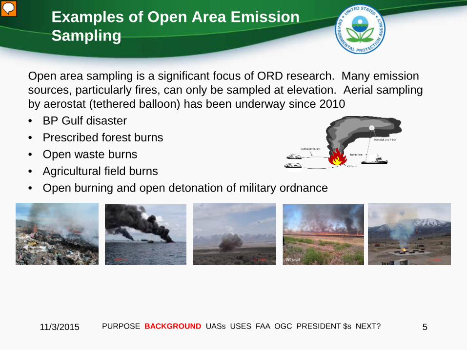
Open area sampling is a significant focus of ORD research. Many emission sources, particularly fires, can only be sampled at elevation. Aerial sampling by aerostat (tethered balloon) has been underway since 2010• BP Gulf disaster• Prescribed forest burns• Open waste burns• Agricultural field burns• Open burning and open detonation of military ordnance
11/3/2015 PURPOSE BACKGROUND UASs USES FAA OGC PRESIDENT $s NEXT? 5

11/3/2015 U.S. Environmental Protection Agency 6
Sampling Campaigns
Limits on Current Method
11/3/2015 PURPOSE BACKGROUND UASs USES FAA OGC PRESIDENT $s NEXT? 7
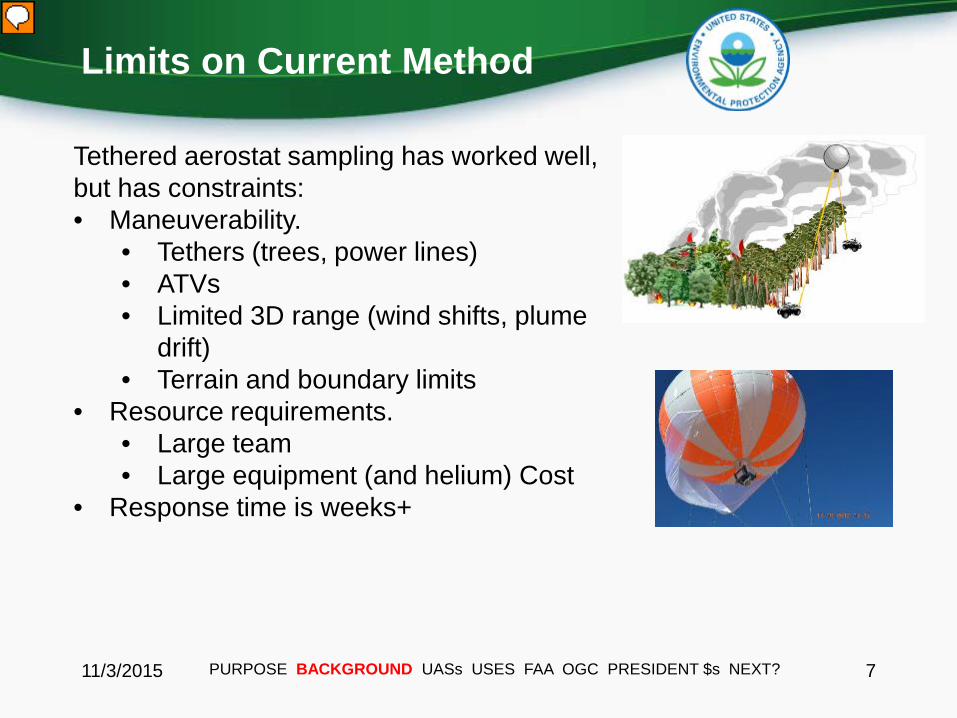
Tethered aerostat sampling has worked well, but has constraints:• Maneuverability.
• Tethers (trees, power lines)• ATVs• Limited 3D range (wind shifts, plume
drift)• Terrain and boundary limits
• Resource requirements.• Large team• Large equipment (and helium) Cost
• Response time is weeks+

UASs
11/3/2015 PURPOSE BACKGROUND UASs USES FAA OGC PRESIDENT $s NEXT? 8
• Advances in GPS, carbon fiber, computer, and battery technologies have led to UAS development, particularly for multicopters.
• They are varied in size and capability; some as small as a dollar bill.• They are operator controlled or fly programmed paths• They have auto-return, boundary, and auto-land features• Personnel are safely at a distance• Recent designs can carry payloads of 5 kg for 15-20 minutes.• They are portable (fold up) and fast to deploy• They do not have a disturbance footprint• Require only two people• Costs range from $50 - $20K

Potential Emission Sampling with UASs
Emissions (NRMRL, B. Gullett, C. Geron, J. Walker, E. Thoma, D. J. Williams)
• Forest fire emissions• Landfills• Crop soil emissions • Animal waste land applications • Agricultural burns• Lagoon, water body emissions • Industrial open area sources• Flares
11/3/2015 PURPOSE BACKGROUND UASs USES FAA OGC PRESIDENT $s NEXT? 9
Miniaturized sensor package for air sampling developed under EM-3 – the “Kolibri”
Components

Kolibri vs. Flyer
11/3/2015 U.S. Environmental Protection Agency 10
3.56 kg, 15 x 15 x 30 cm
>21kg, 55 x 50 x 45 cm

Emission Sampling Platforms
11/3/2015 11
The Kolibri is 3.56 kg and measures • CO2, • CO, • PM2.5, • Volatile organics• Black Carbon, • Brown Carbon.
The “Kolibri”
PM Pump (under)
PM Filter
Volatiles Pump
CO & CO2 Pump
CO2 NDIR SensorCO Sensor
Particle Filter
VOC Sorbent
Micro SD
Black and Brown Carbon (under)
Battery(under)
Board for Control, Power, Communications and Data Logging
Power and Flow Controller for PM
PURPOSE BACKGROUND UASs USES FAA OGC PRESIDENT $s NEXT?
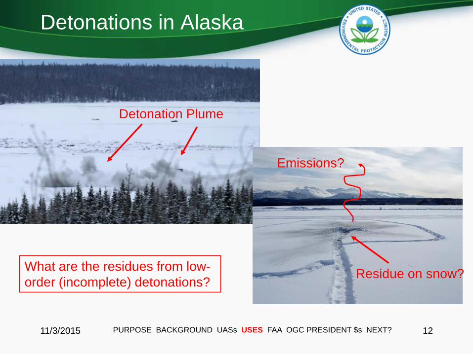
Detonations in Alaska
11/3/2015 12
Detonation Plume
Residue on snow?What are the residues from low-order (incomplete) detonations?
Emissions?
PURPOSE BACKGROUND UASs USES FAA OGC PRESIDENT $s NEXT?

Development of lightweight sensor packages for aerial measurements
First flight in Anchorage, AK, Feb. 11, 2015 Data from C4
detonations in Alaska
In the plume
On the ground, in parking lot
Gas sensor data from the plume:
PURPOSE BACKGROUND UASs USES FAA OGC PRESIDENT $s NEXT?
Univ. of Alaska – Fairbanks’ Hexacopter
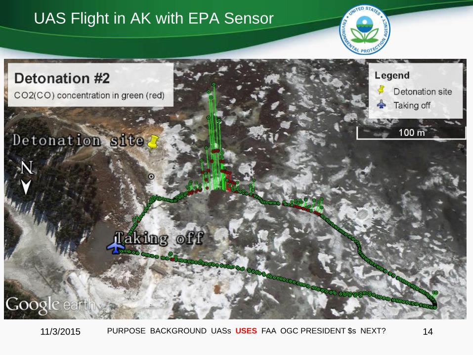
UAS Flight in AK with EPA Sensor
11/3/2015 14PURPOSE BACKGROUND UASs USES FAA OGC PRESIDENT $s NEXT?

Uses for UASs other than emissions
Water• Cyanobacteria detection, algal bloom density (NERL, J.
Iiames)• Nutrient transport (NERL, D. Williams)• Water samplingLand Ecology• Erosion• Moisture• Vegetation type, amount, morphology (i.e. leaf area index• Land mapping, imagery atlas (D. Pilant, B. Schaeffer)Emergency Response
11/3/2015 PURPOSE BACKGROUND UASs USES FAA OGC PRESIDNET $s NEXT? 15
Carrick Detweiler, U. Nebraska-Lincoln. Used by permission.
Mark Blanks, Kansas State Univ. Used by permission.

Forest Structure
11/3/2015 16
UAS systems would conduct systematic 3D sampling of forest stand structure and height to yield biomass estimates. These are input into atmospheric modeling for prediction of ?
Canopy and bare earth surfaces
PURPOSE BACKGROUND UASs USES FAA OGC PRESIDENT $s NEXT?
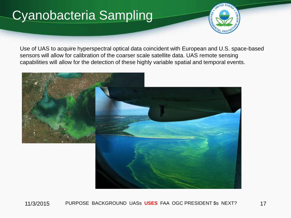
Cyanobacteria Sampling
11/3/2015 17
Use of UAS to acquire hyperspectral optical data coincident with European and U.S. space-based sensors will allow for calibration of the coarser scale satellite data. UAS remote sensing capabilities will allow for the detection of these highly variable spatial and temporal events.
PURPOSE BACKGROUND UASs USES FAA OGC PRESIDENT $s NEXT?
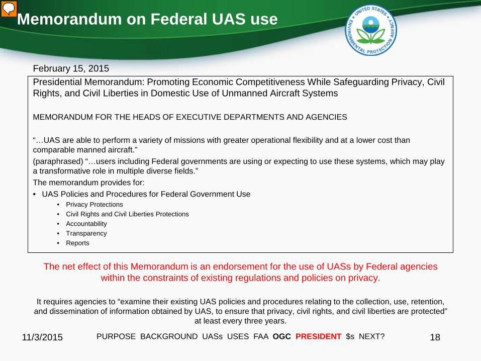
Memorandum on Federal UAS use
February 15, 2015Presidential Memorandum: Promoting Economic Competitiveness While Safeguarding Privacy, Civil Rights, and Civil Liberties in Domestic Use of Unmanned Aircraft Systems
MEMORANDUM FOR THE HEADS OF EXECUTIVE DEPARTMENTS AND AGENCIES
“…UAS are able to perform a variety of missions with greater operational flexibility and at a lower cost than comparable manned aircraft.”(paraphrased) “…users including Federal governments are using or expecting to use these systems, which may play a transformative role in multiple diverse fields.” The memorandum provides for:• UAS Policies and Procedures for Federal Government Use
• Privacy Protections• Civil Rights and Civil Liberties Protections• Accountability• Transparency• Reports
The net effect of this Memorandum is an endorsement for the use of UASs by Federal agencies within the constraints of existing regulations and policies on privacy.
It requires agencies to “examine their existing UAS policies and procedures relating to the collection, use, retention, and dissemination of information obtained by UAS, to ensure that privacy, civil rights, and civil liberties are protected”
at least every three years.
11/3/2015 PURPOSE BACKGROUND UASs USES FAA OGC PRESIDENT $s NEXT? 18

Benefits of Environmental Use
• Responsiveness: Reduces response time to 1 day• Decreases personnel from 6 to 2 (aerostat sampling)• Significantly reduces cost of field sampling• Drastic increase in our ability to characterize sources• Allows us to characterize heretofore unsampled sources• A natural platform for our sensor program• Makes use of algorithms in place to characterize sources• Complementary to fenceline, stack, and mobile source methods• Allows ORD to be more responsive to Program and Region needs• Significant safety advantage due to personnel set back distance
11/3/2015 PURPOSE BACKGROUND UASs USES FAA OGC PRESIDENT $s NEXT? 19

Case Study: Comparing Methods of Wildland Fire Emission Sampling
11/3/2015 U.S. Environmental Protection Agency 20
• Wildland fires are not possible to predict where and when they occur. Even prescribed fires are subject to the daily whims of weather.
Response Time
Ground-based samplers Airplane-based samplers Aerostat-lofted samplers UAS samplers
Generally medium-fast response time for EPA personnel.
Requires advance access to a plane and time to outfit aircraft, perhaps 6-8 weeks.
Requires 5-6 people which slows response to 2-3 weeks.
Fast response time: 1-2 days – only two EPA personnel required.

Case Study: Comparing Methods of Wildland Fire Emission Sampling
11/3/2015 U.S. Environmental Protection Agency 21
• Does the sampling present a biased sample which is not representative? How many sources can be sampled by each method?
Impact of Data
Ground-based samplers Airplane-based samplers Aerostat-lofted samplers UAS samplers
Ground based samples can provide a bias toward smoldering, rather than flaming, emissions. Safety concerns over personnel proximity can limit the types of sources that can be sampled. Likely 2-3 sources can be sampled per year.
Lofted plume samples from airplanes provide a bias toward flaming combustion emissions rather than near-ground exposure emissions. Generally only larger fires can be sampled. Residence time in plume can be short, limiting sample value. Likely only 1 source per year can be sampled.
Provides a good sample mix of both smoldering and flaming emissions. Required proximity to fire limits sampling to moderate fires. Likely 2-3 sources per year can be sampled.
Freedom of movement provides an excellent sample mix of both smoldering and flaming emissions. Remote piloting allows for a broader range of fire types to be sampled. Likely 5-10 sources per year can be sampled.

Case Study: Comparing Methods of Wildland Fire Emission Sampling
11/3/2015 U.S. Environmental Protection Agency 22
• Safety concerns can limit access and personnel proximity to fires, potentially compromising sample quality (strength and representativeness).
Personnel Safety
Ground-based samplers Airplane-based samplers Aerostat-lofted samplers UAS samplers
Personnel safety dictates PPE requirements and proximity to fires, limiting the types of fires that can be sampled and the representativeness of the measurements.
Safety is generally not an issue with airplane sampling, although plume thickness and turbulence will place limits on what plumes can be sampled.
Personnel safety dictates PPE requirements and proximity to fires, limiting the types of fires that can be sampled and the representativeness of the measurements.
The ability to pilot at a distance from the UAS provides greater assurance of personnel safety. The autonomy of the equipment also presents less risk to the equipment.
Case Study: Comparing Methods of Wildland Fire Emission Sampling
11/3/2015 U.S. Environmental Protection Agency 23
• Does EPA own and operate the equipment or is a contractual mechanism required for the sampling?
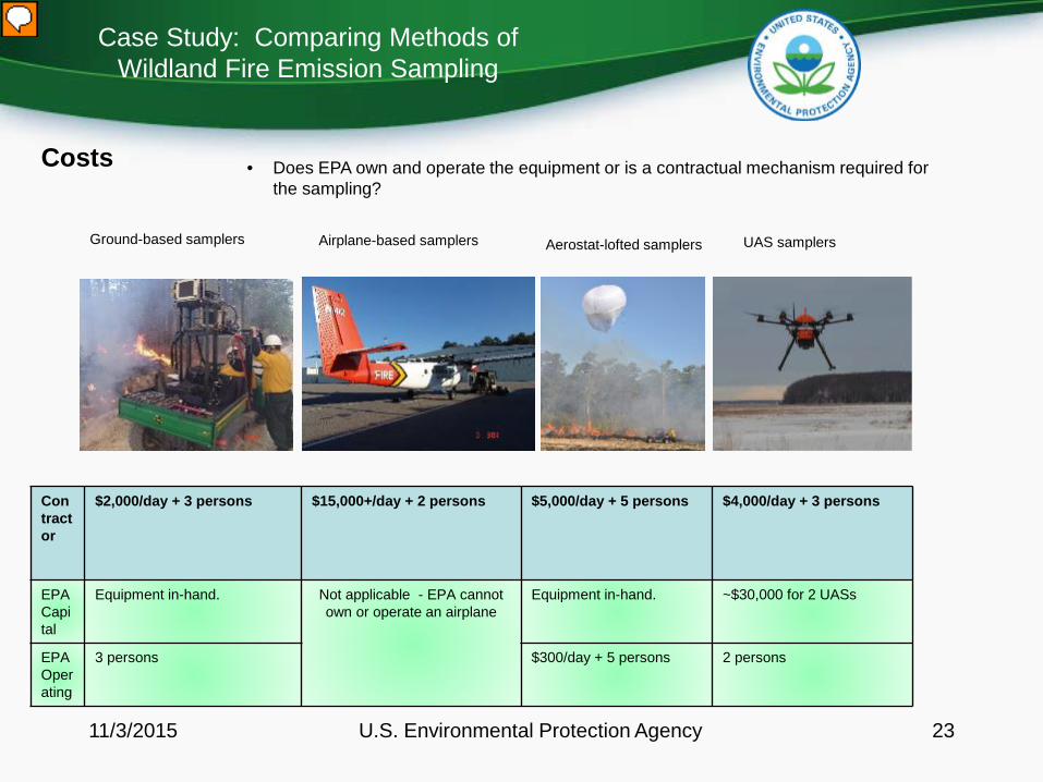
Costs
Ground-based samplers Airplane-based samplers Aerostat-lofted samplers UAS samplers
Contractor
$2,000/day + 3 persons $15,000+/day + 2 persons $5,000/day + 5 persons $4,000/day + 3 persons
EPA Capital
Equipment in-hand. Not applicable - EPA cannot own or operate an airplane
Equipment in-hand. ~$30,000 for 2 UASs
EPA Operating
3 persons $300/day + 5 persons 2 persons
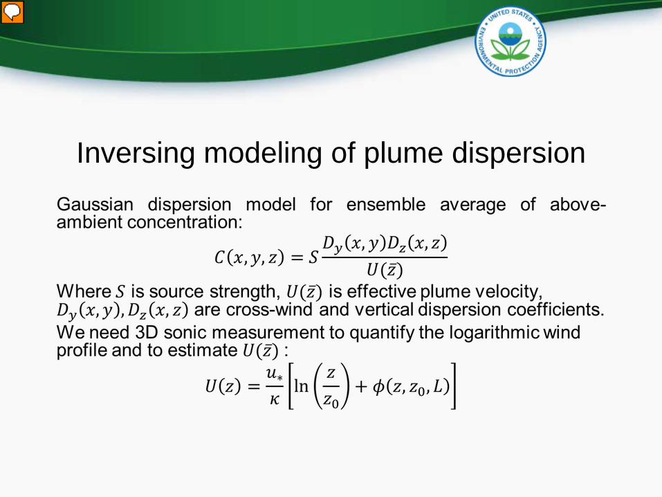
Inversing modeling of plume dispersion

Source Quantification by UAS
Multiple passes of the UAS through the plume determines concentratrion profile and dispersion coefficients; allows calculation of source strength, S.

Brian Gullett, Ph.D.OFFICE OF RESEARCH AND DEVELOPMENT
NATIONAL RISK MANAGEMENT RESEARCH LABORATORYU.S. Environmental Protection Agency
Research Triangle Park [email protected]
919-541-1534
Unmanned Aircraft Systems (UAS) Workshop, USGS, May, 2015
NATIONAL CENTER FOR ATMOSPHERIC RESEARCH
UAS Applications in Emission Sampling