u0 utility dngir - welcome to greater noida | greater noida. s… · · 2015-10-06under...
TRANSCRIPT
Project:
Client:
Consultant:
Drawing title:
Scale:
CONSULTANCY SERVICES FOR MASTER PLAN,PRELIMINARY DESIGN
REPORT ALONG WITH TENDER DOCUMENTS FOR DEVELOPMENT OF
TRUNK INFRASTRUCTURE FOR INTEGRATED INDUSTRIAL TOWNSHIP
UNDER DADRI-NOIDA-GHAZIABAD INVESTMENT REGION OF DMIC
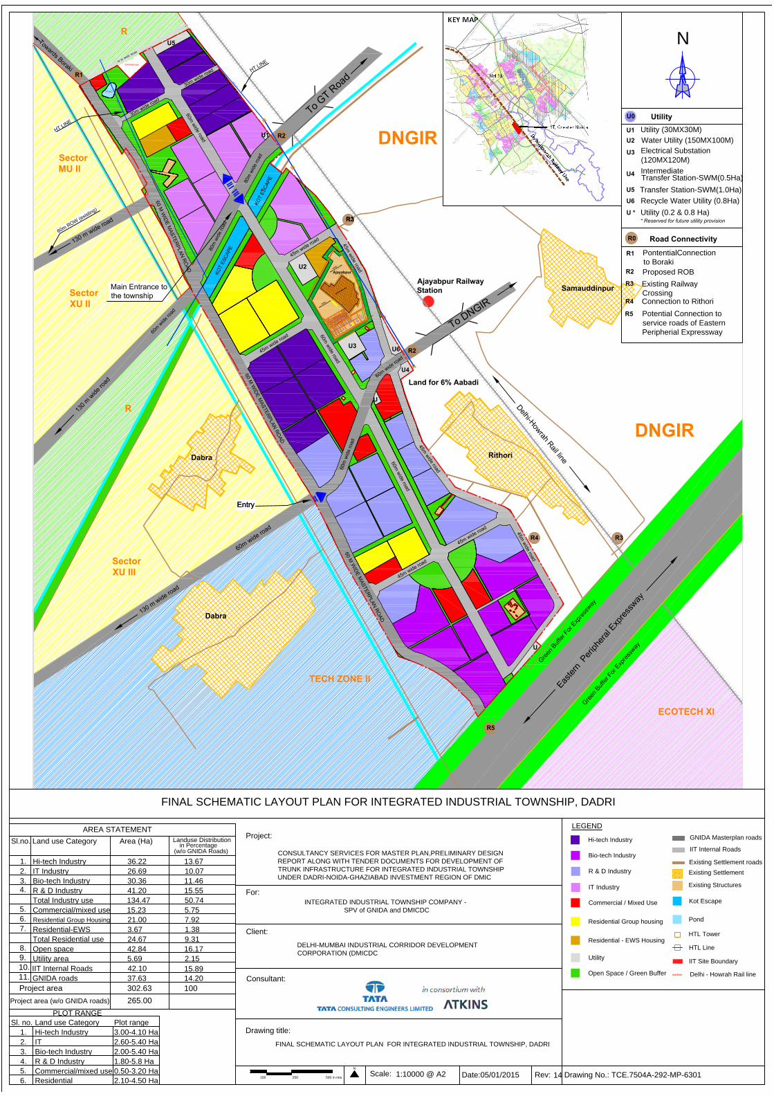
FINAL SCHEMATIC LAYOUT PLAN FOR INTEGRATED INDUSTRIAL TOWNSHIP, DADRI
1:10000 @ A2Rev:
N
For:
INTEGRATED INDUSTRIAL TOWNSHIP COMPANY -
SPV of GNIDA and DMICDC
100 250 500 in mts
LEGEND
Date:05/01/2015 14
FINAL SCHEMATIC LAYOUT PLAN FOR INTEGRATED INDUSTRIAL TOWNSHIP, DADRI
2.10-4.50 Ha
AREA STATEMENT
1.
2.
3.
Sl.no. Land use Category
Hi-tech Industry
Bio-tech Industry
R & D Industry
Commercial/mixed use
Residential Group Housing
Residential-EWS
Open space
Utility area
Area (Ha)
Landuse Distribution
in Percentage
PLOT RANGE
Sl. no. Land use Category Plot range
1.
2.
3.
4.
5.
Hi-tech Industry
Bio-tech Industry
R & D Industry
Commercial/mixed use
Residential
3.00-4.10 Ha
2.00-5.40 Ha
1.80-5.8 Ha
0.50-3.20 Ha
36.22
26.69
30.36
15.23
21.00
3.67
42.84
5.69
13.67
10.07
11.46
5.75
7.92
1.38
16.17
2.15
Total Industry use
Total Residential use
IIT Internal Roads
Project area 302.63 100
GNIDA roads
265.00Project area (w/o GNIDA roads)
134.47 50.74
24.67 9.31
15.89
14.20
42.10
37.63
Existing Structures
HTL Tower
Delhi - Howrah Rail line
Pond
IIT Internal Roads
GNIDA Masterplan roads
Existing Settlement roads
HTL Line
Kot Escape
Existing Settlement
N
Drawing No.: TCE.7504A-292-MP-6301
4.
5.
6.
8.
9.
10.
7.
11.
IT Industry
41.20 15.55
IT 2.60-5.40 Ha
6.
Open Space / Green Buffer
Hi-tech Industry
Bio-tech Industry
R & D Industry
Commercial / Mixed Use
Residential Group housing
Residential - EWS Housing
Utility
IT Industry
(w/o GNIDA Roads)
ECOTECH XI
TECH ZONE II
Sector
XU III
R
Sector
XU II
Sector
MU II
R
DNGIR
DNGIR
IIT Site Boundary
DELHI-MUMBAI INDUSTRIAL CORRIDOR DEVELOPMENT
CORPORATION (DMICDC
Utility
Road Connectivity
U0
U1
U2
U3
U4
U5
Water Utility (150MX100M)
Intermediate
Transfer Station-SWM(0.5Ha)
Electrical Substation
(120MX120M)
Transfer Station-SWM(1.0Ha)
R1
R2
R3
R4
R5
PontentialConnection
to Boraki
Proposed ROB
Existing Railway
Crossing
Connection to Rithori
Potential Connection to
service roads of Eastern
Peripherial Expressway
Utility (30MX30M)
R0
* Reserved for future utility provision
Utility (0.2 & 0.8 Ha)U *
U6 Recycle Water Utility (0.8Ha)