u. s. fish & wildlife service transportation needs and ...€¦ · transportation system and...
TRANSCRIPT
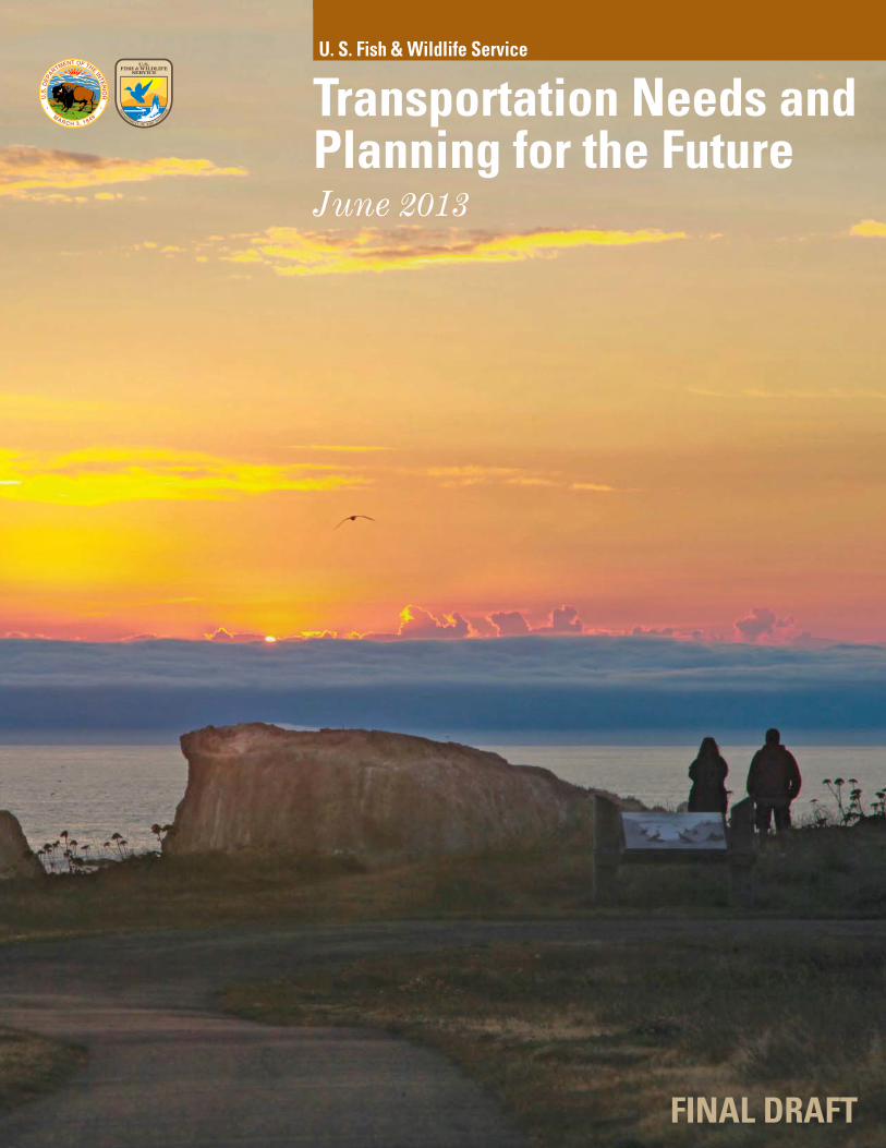
Transportation Needs and Planning for the FutureJune 2013
U. S. Fish & Wildlife Service
FINAL DRAFT

Moving Ahead for Progress in the 21st Century (MAP-21) is a two-year surface transportation legislation that authorizes transportation improvement funding to the FWS through September 2014.
This document highlights the Service's transportation needs across all program areas in preparation for continued dialogue about the importance of the FWS Transportation Program, which provides quality visitor experiences and recreational opportunities in America's Great Outdoors. The Service will continue to refine these needs and focus on priority improvements.
Introduction
To ensure that the FWS Transportation Program supports the Service’s mission and goals, the Program is structured around six goal categories, which together, embody the mission of the Service as expressed through its transportation system and are consistent with U.S. Department of Transportation goals. The following goals serve to guide transportation decisions and policies over the long term in ways that not only benefit the transportation system, but also help the agency achieve its overall mission:
Environmental and resource protection
Safety
Transportation asset management
Access, mobility, and connectivity
Visitor experience
Coordinated opportunities and partnerships
The U.S. Fish and Wildlife Service (FWS or Service) is responsible for conserving, protecting, and enhancing fish, wildlife and plants and their habitats for the continuing benefit of the American people through diverse programs and activities. The FWS fulfills this mission through direct lands management, protection of threatened and endangered species, ecological services and conservation planning, among other programs.
The FWS manages a network of land and facilities in each of the 50 States, including Puerto Rico, Virgin Islands, and Guam.
FWS is entering its 15th year in formal partnership with the Federal Highway Administration (FHWA) to improve transportation on FWS lands. This constitutes half of the 30-year existence of FHWA’s Federal Lands Highway Program. Through the management of the FWS Transportation Program, FWS has led in a number of areas, including project delivery, data collection, and planning. As a successful, time-tested Federal Lands Highway Program partner, the FWS is poised to take additional strides forward.
The FWS Transportation Program supports improved public access to and within FWS lands. The FWS Transportation Program encompasses a number of surface travel modes other than personal automobiles, including bicycles, foot trails, transit vehicles, and docks/boat launches. This entire transportation system is critical to meeting goals and implementation measures related to the Administration’s America’s Great Outdoors initiatives – a program that highlights improved access as a key to quality visitor experiences and improved, local economic benefits.
150million acres
561national wildlife refuges
70national fi sh hatcheries
38wetland management districts
5,400miles of public use roads
300public use bridges
2,100miles of trails
16alternativetransportation systems
1

The needs of the FWS Transportation Program’s transportation system far exceed the current
availability of funding
2

Funding Scenarios and Program Outcomes
The FWS Transportation Program has maintained assets in a good state of repair over the past decade while also striving to improve the condition of assets that have fallen into disrepair. Often, the assets that need to be improved significantly or replaced are those that are both complex and expensive. The FWS Transportation Program has demonstrated it needs to sustain a higher level of improvement and to achieve its programmatic goals.
Investment in the FWS Transportation Program will continue to yield benefits to our visitors seeking recreational opportunities on Service lands. The FWS Transportation Program is actively developing programs to ensure that transportation conditions and access continue to improve through improved decision making processes.
In order to continue the FWS Transportation Program’s successful record of improving system-wide conditions, a more robust FHWA Federal Lands Transportation Program (FLTP) that addresses documented needs is vital. MAP-21 brought a $1 million increase (to $30 million annually) in dedicated funding to FWS above the $29 million annually under the
previous Refuge Roads Program. This increase does not offset or cover the nearly $7 million annually (on average) awarded previously to FWS from now eliminated programs, including the Paul S. Sarbanes Transit in Parks (TRIP) and the Public Land Highway Discretionary Programs, to name a few.
Building on the successful stewardship of the $30 million provided annually under FLTP, the FWS Transportation Program is proposing two scenarios to address needs. These scenarios currently pivot off of nationwide estimates determined from various analyses described in greater detail in subsequent sections.
The first proposed scenario is the “Fully-Implemented Program” where the FWS Transportation Program would be funded at $95 million per year. The second proposed scenario is an “Enhanced Program” to be funded at $60 million annually, though this level remains short of the true needs of the FWS Transportation Program across program areas. The table below provides a breakdown of the program needs for both scenarios, as well as summary descriptions of the return on investment.
FWS Transportation Funding Scenarios (current funding is $30 million a year)
Program Area
Enhanced Program($60 million/year)
Fully-Implemented Program($95 million/year)
Less frequent reconstruction and rehabilitation
Pavement management approaches/treatments only on high-priority assets
Pilot implementation of transit at key locations
Advance some projects delayed as a result of programs eliminated in MAP-21
Successfully deliver 1 large project per year
Aggressive reconstruction and rehabilitation schedule;
Pavement management approaches to fi x defi cient roads in fi rst 5 years;
Address additional transit and trail needs
Advance all projects delayed as a result of programs eliminated in MAP-21; and
Successfully deliver 2 to 3 large projects per year.
Roads $37 $57
Bridges $4 $6
Transit $2.5 $3
Trails $1.5 $2
Environmental Improvements $4 $6
Transportation Planning $3 $3
Large Project Needs $5 $15
FHWA Administrative Costs $3 $3
Total $60 million/year $95 million/year
3

Roads and Parking Lots
Although the FWS’s transportation system provides mobility choices at some field stations, roads provide the most widely used forms of travel to and within FWS lands. There are over 5,400 miles of public use roads and over 5,000 parking lots within the FWS system. As such, roads play a significant role in how the FWS Transportation Program manages its transportation assets to meet its goals for safety; asset condition; access; and visitor experience.
Data and Decision MakingThrough wise management of its transportation assets, the FWS Transportation Program improves and extends the life of public use roads. The FWS effectively collects and uses data regarding the condition of its roadway inventory and parking areas. A robust bridge inspection program also provides important data. These data and information are essential for the FWS’s decision making process, which informs how, when, and where the FWS Transportation Program should improve its transportation system. This data-informed process is also helpful in fulfilling the Service’s commitment to measure and monitor performance of its Transportation Program (including roads and parking lots) over time.
The FWS Transportation Program uses data to help overcome limited resources and focus maintenance and other improvements on roads that are the most important to furthering the FWS’s mission. Having reliable data about road
priority and condition are therefore essential for directing resources to the most suitable roads. FWS is a leader in data collection on gravel roads and in using the collected data to set priorities and maintenance practices.
NeedsInformed decision making exemplifies the FWS Transportation Program's goal of being a good investment of transportation dollars. Indeed, the condition of FWS roads has improved steadily with increased funding provided through previous surface transportation authorizations. The Program’s responsible use of transportation funds is further demonstrated in how, despite showing how documented needs exceed available funds, overall condition ratings and visitor satisfaction have remained steady or improved slightly.
The road needs of the FWS Transportation Program are further illustrated in a recent FWS National Pavement Management Analysis prepared by FHWA in May 2013. The outcome of this work shows resulting road conditions into the future with varying levels of funding (see adjoining figure). Starting with an initial investment in 2013, the analysis found that with increased funding of $37 million/year or $57 million/year to meet just road improvement needs, the overall road condition of the system improved markedly. With a planning goal of a Pavement Condition Rating of 80 (translating to majority of roads in good or better condition), the Fully-implemented Scenario need of $57 million each year for roads alone would help FWS achieve this rating by the year 2017 and beyond.
73%
27%
Gravel Roads
89%
11%
Paved Roads
34%
66%
Dirt/Native Roads
Public Use
Administrative Use
76%
24%
Parking Lots
Source: Service Asset Maintenance Management System (SAMMS)
FUNDING SCENARIOS:
Fully Implemented – $57 million
Enhanced – $37 million
4

Moving AheadThe future of improved roads and parking lots within FWS lands relies on continued improvements to data collection, decision making processes and meeting documented needs. The improvements to data and decision making processes are underway and thoroughly documented in FWS Transportation Programs’ extensive national and regional long range transportation planning efforts. Through FHWA’s Pavement Management Analysis, the two funding scenarios and existing funding that were modeled for their impact on road conditions show that with increased funding the Service begins to meet road condition needs and goals into the future.
FWS Nationwide Roads Analysis - Performance Summary
201340
50
60
70
80
90
100
2014 2015 2016 2017
Pave
men
t Con
ditio
n Ra
ting
(PCR
) PCR 80 = majority of FWS roads in good condition
$57M/yr (FullyImplemented Program)
Funding for Roads Only
$37M/yr EnhancedProgram)
$27M Annually(Existing MAP-21Funding - all to roads)
Do Nothing($0M)
Source: FHWA May 2013
5
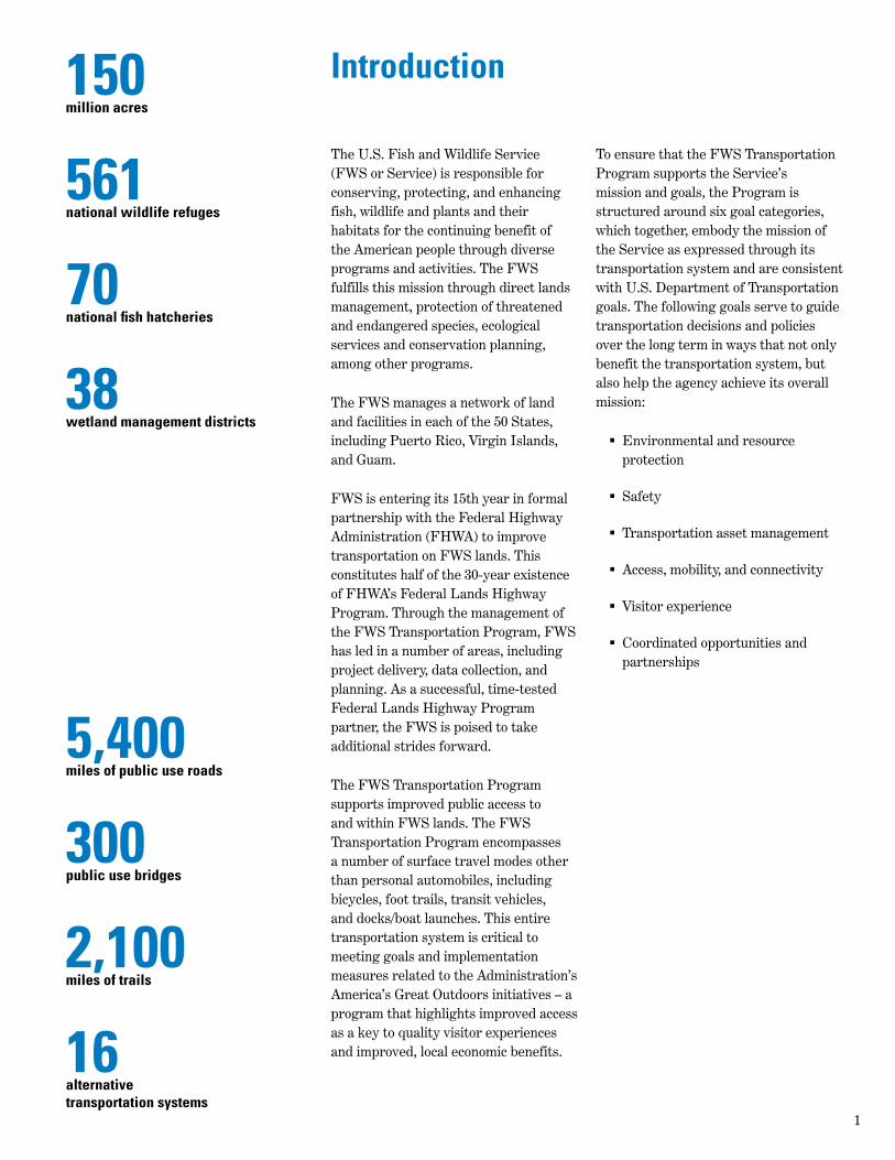
The 300-plus public bridges managed by the FWS are an integral part of the public road and trail system that provides
access to refuge facilities, auto tour routes, and wildlife observation facilities
6

Bridges
The 300-plus public bridges managed by the FWS are an integral part of the public road system that provides access to refuge facilities and to auto tour routes.
The safety of the public and of FWS employees has been and always will be the highest priority. In the spirit of maintaining a safe transportation network, the FWS has found it necessary to close unsafe bridges from time to time. These bridge closures limit public recreational opportunities (such as hunting and fishing) and lengthen response times for emergency vehicles. The goal is to replace these bridges as soon as possible to limit the impact that bridge closures have on Refuge visitors and emergency responders.
While the replacement of failed and poor bridges is an essential part of the FWS Transportation Program, it is only one component of a robust bridge program. Recognizing that the “worst first” model of asset management is not an effective way to efficiently use limited resources, the FWS has shifted to the more efficient “preservation” model to ensure that bridges that are in fair or satisfactory condition are
70%
30%
Road Bridges
47%53%
Road Culvert
Public Use
Administrative Use
76%
24%
Trail Bridges
Source: Service Asset Maintenance Management System (SAMMS)
effectively maintained to keep them from deteriorating to poorer condition.
The FWS has made a concerted effort to improve bridge safety for nearly two decades. The FWS’s dedication to this effort can be gauged by reviewing the overall condition rating of our bridge assets over time. In 2002, 45% of public access bridges were rated as being in good or better condition. Today, that number stands at over 60%. Over 30% of public bridges are in fair to satisfactory condition and need to be maintained to reduce deterioration to poor or failed condition.
The FWS initiated a bridge safety program in 1994 to ensure that all FWS bridges are routinely inspected and to comply with the National Bridge Inspection Standards (NBIS). The FWS manages this program, and continually strives to improve the quality of the information gathered and reported to the National Bridge Inventory (NBI). Recently, in acknowledging receipt of the most recent submission of FWS NBI data, the Federal Lands Highway Bridge Office noted that “…the [FWS bridge] data has historically been very good and continues to improve.” Also, Federal Lands Highway conducted an NBIS compliance review of the FWS bridge safety program in 2012 and noted that “…the performance of the FWS bridge program is very good with many areas of commendable practices…”
FUNDING SCENARIOS:
Fully Implemented – $6 million
Enhanced – $4 million
7
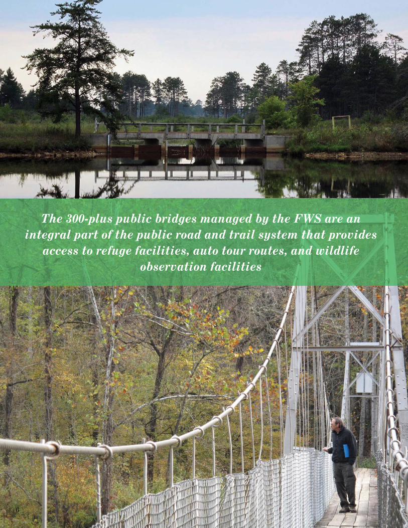
Transit and trails ensure that lands open to public visitation have adequate access, mobility, and connectivity
for all potential users
8

Transit and Trails
While roads on Service lands currently serve as the primary means of transport to and within the majority of FWS lands, trails and transit systems provide a vital linkage at select refuges as shown in annual Service public use reports. Multimodal transportation options (e.g., trails, trams, and bicycles) are essential at refuges and hatcheries that may have geographical constraints, such as those that require water-based access, and provide for a variety of visitor experiences. In order to meet its greenhouse gas emissions goals and to provide access to a wider range of visitors across income, race, and ability spectrums, the Service has determined that multimodal forms of transportation are essential.
Trails are one of the primary ways that the Service has for allowing adults and children to participate in wildlife observations and environmental education activities. With over 2,100 miles of land trails and boardwalks, and an estimated 1,000 miles of water trails, refuges and hatcheries provide important recreational opportunities for visitors. Many of these trails are nationally recognized for their historic or scenic significance. FWS trails inventory has determined that over 90% of the Service’s trails are in good condition.
Despite these advancements, much more can be done to improve accessibility to surrounding communities.
The Service manages transit systems that generally consist of one- to two-car trams (or equivalent) used to transport visitors on tour routes. Most of the Service managed transit systems operate seasonally. Public transit systems and trails from local communities also connect to refuges in a number of areas. The Service also has ferry boats available for public use, such as at the Kenai NWR (AK). The ferry boats usually work seasonally or on a reservation basis.
The Paul S. Sarbanes Transit in Parks (TRIP) Program, now eliminated in MAP-21, provided dedicated funding for the planning and implementation of alternative transportation systems. The TRIP Program aided the Service in updating its old transit vehicles, addressing increased vehicle congestion, improving trail connectivity, and helping local communities with alternative transportation planning studies.
The TRIP Program funded 43 Service projects from 2006-2012, totaling nearly $20 million in funding strictly dedicated to alternative transportation.
The repeal of the TRIP Program in MAP-21 leaves a void in the planning for continued advancements for the
Service’s transit systems and trails. An additional 25 projects for which TRIP applications were submitted remain unfunded. These 25 projects totaled over $16 million in proposed alternative transportation enhancements. The fully-implemented funding scenario provides for a total of $5 million annually to support the completion of these unfunded TRIP projects, as well as newly identified transit and trails needs. It is unclear if the new eligibility to fund transit and trails in MAP-21 Programs will meet the Service’s and nearby communities needs for multi-modal access.
Examples of Success
National Elk Refuge in Wyoming The North 89 Pathway runs along the western side of the National Elk Refuge north of the town of Jackson, WY. TRIP grants, acquired through a partnership between the refuge and Teton County, contributed over half of the project’s $4.8 million cost. Completed in September 2011, the pathway traverses six miles on the refuge and connects visitors to the Grand Teton National Park and its trail system. Visitors can access the National Wildlife Art Museum from the trail, as well as enjoy public artwork along the way.
Santa Ana National Wildlife Refuge in Texas In 2006, Santa Ana NWR in the Rio Grande Valley received a TRIP grant to upgrade its tram fleet. These trams feature better fuel economy, improved safety features, and accessibility for visitors in wheelchairs. Since 1982, trams operating along Wildlife Drive allow visitors to learn more about the refuge’s history and natural characteristics. Combined with a private vehicle ban along the road, the tram helps limit intrusion and disturbance for wildlife species.
Sarbanes Grant Locations
FUNDING SCENARIOS:
Fully Implemented – $5 million
Enhanced – $4 million
9

Design guidelines help ensure that transportation projects on FWS managed lands conform to the planning and design
criteria established to support the agency’s mission
10

Environmental Improvements
By providing access to refuges and hatcheries, the FWS Transportation Program directly supports the agency’s mission to protect fish, wildlife, plants and their habitats. The FWS Transportation Program ensures that mission critical access to fish, wildlife, plants and their habitats is available, safe, and appropriately meets the demands of both public and administrative use. The FWS Transportation Program also works to minimize impacts to resources, and to diligently reduce existing stressors caused by transportation.
Roads have a significant impact on wildlife populations and habitat, and there are a variety of opportunities to mitigate these impacts within and surrounding the transportation system. Examples of potential impacts include the following:
Roads can directly impact wildlife through mortality. Wildlife-vehicle collisions are also a safety concern for motorists.
Roadways can have dramatic impacts on hydrology at local, regional, and watershed scales. Impervious surfaces have a cumulatively negative effect across a watershed, altering its hydrology and often creating detrimental consequences for fish, wildlife and plants. Design sensitive roadway projects present opportunities to protect and restore native vegetation and past hydrologic features.
Roadways create barriers to wildlife movement and lead to habitat fragmentation. Ensuring that organisms are able to safely move across (either over or under) roadways to meet basic life requisites is imperative to meeting the FWS’s mission.
Runoff from roadways can carry unwanted pollutants into adjacent streams and water bodies. It can also adversely affect the temperature of the receiving water bodies.
The FWS has been increasingly working to find creative ways to lessen transportation related effects. For example, Kenai National Wildlife Refuge (NWR) has been working with Alaska Department of Transportation to alleviate wildlife-vehicle interaction issues. Staff are working towards funding and implementing a wildlife crossing underpass and other mitigation features on the Sterling Highway. This future project will improve safety for drivers and also allow for safer crossing of moose, bear, and caribou. Due to the high number of wildlife-vehicle collisions, multiple agencies are working together to identify the crossing hotspots.
The FWS has also partnered with the United States Geological Survey (USGS) to study the effects of dust suppressants. Application of these suppressants will soon be conducted on refuges in a safe, controlled test. The results of USGS research will identify safe products that can be used to limit the risk of applied suppressants to fish, wildlife, and their habitats.
Best practices will be shared widely with local, state and Federal agencies responsible for the permitting or application of dust suppressants on gravel roads.
The FWS Transportation Program is also working to support environmental considerations and road ecology in transportation through the development of specific Roadway Design Guidelines, which were developed in partnership with FHWA. These guidelines are a tool for facilitating dialog and decision making among project teams. This guide highlights state of the art ecological, planning, design and engineering considerations for roadway projects. The Roadway Design Guidelines help ensure that projects on FWS managed lands conform to the planning and design criteria established to more directly support the FWS mission.
FUNDING SCENARIOS:
Fully Implemented – $6 million
Enhanced – $4 million
11

The FWS Transportation Program provides clear direction on developing meaningful transportation plans, performance management, coordinating actions, and collecting the data
and analysis necessary to make good decisions
12

Transportation Planning
Transportation planning and setting priorities in constrained fiscal times is important. The FWS Transportation Program is committed to helping decision makers systematically incorporate the most relevant data, information and understanding into their decisions. The following FWS Transportation Program responsibilities are areas of success, which continue to be reinforced through a number of program-wide planning activities.
Program Cohesion. Through transportation planning, the FWS Transportation Program solidifies its connection of agency mission, to long range transportation goals, to day-to-day and long term decision making. This is accomplished by parsing transportation needs into FWS Transportation Program goal categories, and clearly defining expectations for how transportation needs and actions are determined and addressed at every level of FWS planning. Priorities are being determined by the six transportation
goal areas of: asset management and deferred maintenance, safety, access, environment, visitor experience, and partnerships.
Performance Management. FWS transportation plans establish consistent metrics—or performance measures—for tracking the FWS’s success in fulfilling its mission and other program-wide targets through its transportation system. Performance management allows regional and national level decision makers to track progress in meeting performance benchmarks, and make corrective action when needed. Performance management also helps quantify the FWS Transportation Program’s successes and illustrate its wise investment of limited transportation funds.
Project Selection. Through national and regional plans, the FWS Transportation Program and its FHWA Federal Lands Highway partners strengthen project selection and prioritization processes. The FWS Transportation Program has an established national project prioritization framework that ensures that projects which best
align with program-wide and regional transportation goals are considered for implementation. The prioritization framework balances regional flexibility with nationwide consistency, thereby contributing to the stability and predictability of the FWS Transportation Program.
Guidance. The FWS Transportation Program provides clear direction to leadership at all levels on developing meaningful transportation plans, performance measurement, coordinating actions, and collecting the information and analysis necessary to make good decisions.
Data Collection and Information Dissemination. Using the six FWS Transportation Program goals as a framework, data gathering processes are being updated to improve the depth and flow of data, information, and knowledge available to decision makers.
Federal requirements. National and regional plans continue to illustrate how the FWS Transportation Program meets its Federal requirements to conduct long-range transportation planning, and meet MAP-21 requirements and meet management goals.
FUNDING SCENARIOS:
Fully Implemented – $3 million
Enhanced – $3 million
13

The FWS Transportation Program approach to funding large projects with limited funds is to set aside regionally allocated
funds each year until there are sufficient resources
14

Large Projects
Individual project needs occasionally exceed funding resources available within a FWS region. The prevailing strategy for overcoming these funding shortfalls for large projects is to set aside regionally allocated funds continuously for several years until there are sufficient resources available to implement the project. Storing funds over several years limits the movement of needed improvements within the transportation system that reasonably fit within the FWS’s constrained budget.
This disruption in timing for certain needs can affect visitor experiences and operation of FWS lands. Often, projects needing a large amount of funding resources are not completed because of the numerous disadvantages associated with holding funds for multiple years. Furthermore, large projects often involve more cooperation with partners. Opportunities are missed when FWS is unable to contribute funds to project partners in a reasonable timeframe.
FWS identified a needs category to potentially help fulfill these larger-value projects into the future. The FWS Transportation Program has several large projects currently waiting full funding that are well above base funding levels received across the U.S. The following are just a few examples of these large, mission-critical projects.
Reconstruct Sunset Drive | Parker River NWR, MA | $3 MillionParker River NWR primarily serves the northeast region of Boston, MA. Sunset Drive is the primary route through the Parker River NWR, accommodating
over 250,000 vehicles per year. One half of the route is gravel, and it was rehabilitated in 2013. But, the paved half of the route remains in disrepair. This project has high importance for the refuge and visitors who frequent the area.
Rehabilitation of Public Use Roads | Crab Orchard NWR, IL | $3.2 MillionWith over 700,000 visitors annually, Crab Orchard NWR has a network of public use roads that provide access to refuge managed campgrounds, boat launches, and other public use areas. Additionally, routes such as Tacoma Lake Road and Devil’s Kitchen Road provide access to private inholdings and function as commuter routes through the refuge supporting surrounding communities. Rehabilitation of 7.7 miles of paved public use roads and two public use parking lots will improve safety for both drivers and bicyclists, extend the lifespan of these critical routes and reduce yearly maintenance needs.
Rehabilitation of Entry Road | Don Edwards San Francisco Bay NWR, CA | $3.9 MillionDon Edwards National Wildlife Refuge (NWR) is an urban refuge which receives nearly 900,000 visitors per year. The entry road crosses a bridge without shoulders, fails to meet seismic standards, and is only separated from the busy State Route 84 by a chain link fence. The project will rehabilitate and widen one-half mile of the entry road; replace Beard Creek Bridge to meet current seismic standards and accommodate bicycles and a sidewalk; overlay deteriorated asphalt; and construct concrete safety barriers between the entry road and the nearby freeway.
Reconstruct Public Use Bridge | Ridgefi eld NWR, WA | $4 to $7 MillionReconstruction of a popular public use bridge would provide long-term public access to the River ‘S’ Unit and help satisfy high visitor demand for access to the Ridgefield NWR Complex. This project will provide a desired transportation solution that benefits refuge resources and the nearby City of Ridgefield.
Reconstruct Wildlife Loop | Chincoteague NWR, VA | $5 MillionChincoteague NWR welcomes over one million visitors each year. The Wildlife Loop is one of the primary refuge attractions as it provides visitors unique opportunities for recreation, interpretation, and wildlife viewing. Damaged in recent storm events, this 3.5-mile loop is reaching a level of heightened disrepair and is in need of rehabilitation, including the repair of several key drainage structures.
Reconstruct Wildlife Loop Road | Patuxent Research Refuge, MD | $15 MillionIn 2012, a 2.5-mile, high priority section of the Wildlife Loop Road was rehabilitated. However roughly 7.5 miles of the road remains in disrepair. Funds would be used to rehabilitate the remaining sections of the Wildlife Loop Road and re-open the entire route to the public, allowing the refuge to offer new and unique environmental education and recreation opportunities in the Baltimore and Washington D.C. metro areas.
FUNDING SCENARIOS:
Fully Implemented – $15 million
Enhanced – $5 million
15

Route 78 Relocation Project | Missisquoi NWR, VT | $8 MillionVermont Route 78 bisects Missisquoi NWR, through prime wetland habitat. FWS, in partnership with the Vermont Agency of Transportation, is working to identify roadway design solutions that would meet both vehicular safety and biological integrity needs, reduce human safety issues on the existing roadway, and avoid damage to important wetland areas.
Construct Wildlife Crossing Structures | Laguna Atascosa, Santa Ana, and Lower Rio Grande Valley NWRs, TX | $12 MillionHome to the endangered ocelot, Laguna Atascosa NWR is seeking funds to install wildlife crossings to reduce the risk of ocelot road mortalities; restore, connect, and increase the availability of ocelot habitat; and minimize habitat loss in the vicinity of the Refuge. Partnership among FWS, Texas Department of Transportation, and Cameron County to install road crossings, fencing, and warning signs would minimize animal mortality and reduce the risk of animal-vehicle collisions.
Construct Wildlife Crossing Structures | Horicon NWR, WI | $60 MillionThe 32,000 acre, Great Horicon Marsh within the refuge is home to many species of birds, frogs, snakes, turtles, and mammals, as well as part of a migratory stop for millions of waterfowl each year. Wisconsin Highway 49 passes through a central portion of the marsh, exposing marshland habitat to heavy traffic and high vehicular speeds. Partnership with Wisconsin Department of Transportation to construct raised causeways, fencing, and warning signs would reduce roadway impacts on marshland and minimize risk of vehicle-animal collision related accidents.
16

Conclusion
The FWS is proud to be entering its 15th year as a partner agency with FHWA, and has witnessed tremendous improvements to its transportation system as a result of this beneficial partnership. A robust, safe, accessible, multimodal transportation system is a fundamental component of achieving the FWS’s mission of conserving, protecting, and enhancing fish, wildlife and plants and their habitats for the continuing benefit of the American people.
FWS has put forth a series of priorities related to MAP-21 reauthorization that will ensure that the FWS can continue to build on its successes to date. These priorities include right-sized increases to funding for the FWS’s Transportation Program based on demonstrated need, greater flexibility for the use of funds, and increased collaboration and guidance. Reauthorization provides a tremendous opportunity to further enhance the FWS Transportation Program to improve visitor access while achieving the intended goals of MAP-21's Federal Lands Transportation Program and other related programs.
17
U.S. Department of the InteriorU.S. Fish & Wildlife Service
http://www.fws gov
Final Draft, June 2013