forest transportation planning under multiple goals using
TRANSCRIPT

15
Forest Transportation Planning Under Multiple Goals Using Ant Colony Optimization
Woodam Chung and Marco Contreras The University of Montana
USA
1. Introduction
For more than a century, forestry practitioners and decision makers have given significant attention to forest transportation planning because transportation is one of the most expensive activities in timber harvesting (Greulich, 2003). The traditional goal of forest transportation planning has been to develop road networks that minimize costs of log hauling and road construction. However, modern forest transportation planning problems (FTPP) are not driven only by the financial aspects of timber management, but also by the multiple uses of roads as well as their social and environmental impacts such as recreation, soil erosion, and stream water quality. These additional considerations and requirements introduce multiple objectives into transportation planning problems, increasing their size and complexity. Two different problem-solving approaches have been applied to solve FTPP; exact algorithms such as mixed-integer programming (MIP) and approximation algorithms generally called heuristics (Falcao & Borges, 2001; Weintraub et al., 1995). MIP has been used to optimally solve these complex FTPP, but its application has been limited by the difficulty of solving large, real world problems within a reasonable amount of computation time (Gottlieb & Paulmann, 1998; Sun et al., 1998). On the other hand, heuristic algorithms, although might not always provide optimal solutions, have been the focus of a large number of researchers because of their high efficiency and problem solving capability especially for large and complex optimization problems (Olsson & Lohmander, 2005; Bettinger and Chung, 2004; Sessions et al., 2003; Zeki 2001; Falcao & Borges, 2001; Martell et al., 1998; Weintraub et al., 1995; Jones et al., 1991). FTPP considering fixed and variable costs form complex optimization problems that to date have only been solved efficiently using heuristic approaches (Kowalski, 2005; Adlakha & Kowalski, 2003). NETWORK II (Sessions, 1985) and NETWORK 2000 (Chung & Sessions, 2003), which use a heuristic network algorithm combined with the shortest path algorithm (Dijkstra, 1959), have been widely used for over twenty years to solve such FTPP. NETWORK 2000 can solve multi-period, multi-product, multi-origin and -destination transportation planning problems. However, it used a single objective function for either profit maximization or cost minimization without taking into account other attributes of road segments modeled as side constraints. A recently developed approach used the ant colony optimization (ACO) to solve FTPP considering fixed and variable costs as well as side constraints (Contreras et al., 2008). This approach provided near-optimal solutions for
www.intechopen.com

Ant Colony Optimization - Methods and Applications
222
small to medium scale FTPP including road construction and hauling costs as well as total sediment yields from the road network as a side constraint. In this paper, we investigated two different problem formulation and solution approaches to handle multiple goals in large scale, real world FTPP. One is the single objective function approach where multiple goals are incorporated into one objective function (Rackley & Chung 2008). The other approach is to formulate transportation problems using side constraints (Contreras et al., 2008). We applied the two approaches to the Mica Creek watershed in northern Idaho in the United States where reducing environmental impacts of forest roads is considered as an additional goal and incorporated into a cost minimization FTPP. In this study, sediment delivery estimated by the USDA Forest Service WEPP: Road is used to represent the environmental impact of forest roads. A heuristic network algorithm implemented in NETWORK 2000 (Chung & Sessions, 2003), and an Ant Colony Optimization algorithm (Contreras et al., 2008; Dorigo et al., 1999) were used to solve the two differently formulated FTPP. The results indicate that solving transportation problems with multiple goals enables us to analyze trade-offs between goals and generate alternative road networks that can reduce both transportation costs and negative environmental impacts.
2. Methods
2.1 Problem formulations
The specific FTPP we address in this paper is to find the set of least-cost routes from multiple timber sale locations to selected destination mills on multiple planning periods, while considering environmental impacts of forest roads represented by sediment yields. As with most transportation problems, these FTPP can be modeled as network problems. The transportation network is represented by a graph, where vertices represent mill locations, timber sale locations, and intersections of road segments, and edges represent the road segments connecting these vertices. Three attributes are associated with every edge in the network: fixed cost, variable cost, and amount of sediment delivery. A fixed cost is a one-time cost which occurs if the road segment is used regardless of traffic volume, whereas a variable cost is typically proportional to traffic or timber volume transported over the road segment. The sediment associated with each edge, expressed in tons per year per edge, represents the amount of sediment eroding from the road segment due to the traffic of heavy log trucks. Similar to fixed cost, we assumed sediment is produced when roads are open regardless of traffic volume.
2.1.1 Single objective function approach
The problem of finding the transportation routes that minimize both the total costs and sediment delivery can be formulated into one objective function as follows:
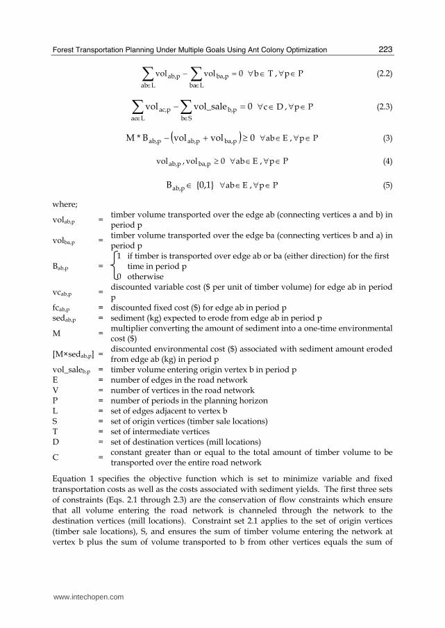
Minimize [ ]( ) ( )[ ]∑∑∈ ∈×++×
Pp Eab
pab,pab,pba,pab,pab, Bfcvolvolvc (1)
Subject to
0volvolvol_sale
Lba
pba,
Lab
pab,pb, =−+ ∑∑ ∈∈ Sb∈∀ , Pp∈∀ (2.1)
www.intechopen.com
Forest Transportation Planning Under Multiple Goals Using Ant Colony Optimization
223
0volvol
Lba
pba,
Lab
pab, =−∑∑ ∈∈ Tb∈∀ , Pp∈∀ (2.2)
0vol_salevolSb
pb,
Lac
pac, =−∑∑ ∈∈ Dc∈∀ , Pp∈∀ (2.3)
( ) 0volvolB*M pba,pab,pab, ≥+− E ab∈∀ , Pp∈∀ (3)
0vol,vol pba,pab, ≥ E ab∈∀ , Pp∈∀ (4)
{0,1} B pab, ∈ E ab∈∀ , Pp∈∀ (5)
where;
volab,p = timber volume transported over the edge ab (connecting vertices a and b) in period p
volba,p = timber volume transported over the edge ba (connecting vertices b and a) in period p
Bab,p = 1 if timber is transported over edge ab or ba (either direction) for the first time in period p 0 otherwise
vcab,p = discounted variable cost ($ per unit of timber volume) for edge ab in period p
fcab,p = discounted fixed cost ($) for edge ab in period p sedab,p = sediment (kg) expected to erode from edge ab in period p
M = multiplier converting the amount of sediment into a one-time environmental cost ($)
[M×sedab,p] = discounted environmental cost ($) associated with sediment amount eroded from edge ab (kg) in period p
vol_saleb,p = timber volume entering origin vertex b in period p E = number of edges in the road network V = number of vertices in the road network P = number of periods in the planning horizon L = set of edges adjacent to vertex b S = set of origin vertices (timber sale locations) T = set of intermediate vertices D = set of destination vertices (mill locations)
C = constant greater than or equal to the total amount of timber volume to be transported over the entire road network
Equation 1 specifies the objective function which is set to minimize variable and fixed transportation costs as well as the costs associated with sediment yields. The first three sets of constraints (Eqs. 2.1 through 2.3) are the conservation of flow constraints which ensure that all volume entering the road network is channeled through the network to the destination vertices (mill locations). Constraint set 2.1 applies to the set of origin vertices (timber sale locations), S, and ensures the sum of timber volume entering the network at vertex b plus the sum of volume transported to b from other vertices equals the sum of
www.intechopen.com

Ant Colony Optimization - Methods and Applications
224
volume leaving vertex b. Constraint set 2.2 applies to the set of intermediate vertices (that are neither origin nor destination vertices), T, and ensures the sum of volume entering vertex b equals the sum of volume leaving that vertex. Constraint 2.3 applies to the destination vertices (mill locations), D, and specifies the sum of volume arriving at destination vertices equals the sum of the timber volume loaded onto the origin vertices, thus ensuring all volume that enters the road network is routed to the destination vertices. The fourth set of constraints (Eqs. 3) represents the road-trigger constraints which makes sure that if there is volume transported over edge ab, the edge must be constructed and open for traffic and thus the sediment amount is counted. Lastly, the fifth and sixth sets of constraints (Eqs. 4 and 5) represent the non-negativity and binary value constraints of our problem formulation, respectively.
2.1.2 Side constraint approach
The transportation problem mentioned above can be also formulated into the following objective function and side constraint.
Minimize ( ) ( )ab,p ab,p ba,p ab,p ab,pp P ab E
vc vol vol fc B∈ ∈
⎡ ⎤⎡ ⎤× + + ×⎣ ⎦⎣ ⎦∑ ∑ (6)
Subject to
( )∑∑∈ ∈≤×
Pp Eab
pab,pab, sedallowable_ Ised p P∀ ∈ (7)
0IBpi
pab,iab, ≥−∑∈ ab E∀ ∈ , p P∀ ∈ (8)
{0,1} I pab, ∈ E ab∈∀ , Pp∈∀ (9)
Equation 6 represents the objective function set to minimize total variable and fixed transportation costs. In addition to the sets of constraints described above (Eqs. 2 through 5), equation 7 represents an additional constraint added to limit the maximum allowable sediment amount (allowable_sed) to be delivered from the entire road network in tons. The ninth set of constraints (Eqs. 8) represents the fixed cost-trigger constraints that ensure that if there is sediment being counted from edge ab (thus volume is being transported over edge ab) in one or more periods, the associated fixed cost is counted only the first time the edge is used. The last set of constraints represents the additional binary value constraints for this formulation.
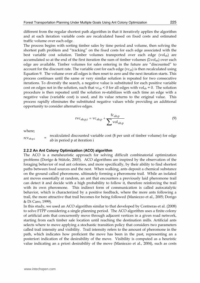
2.2 Solution techniques 2.2.1 A heuristic network algorithm
NETWORK 2000 (Chung & Sessions, 2003) is used to solve the FTPP with the single objective function approach. NETWORK 2000 uses a heuristic network algorithm for optimizing transportation problems, which takes into account both fixed costs (road construction) and variable costs (timber hauling). Although the problem solving technique is based on a shortest path algorithm similar to that proposed by Dijkstra (1959), it is
www.intechopen.com
Forest Transportation Planning Under Multiple Goals Using Ant Colony Optimization
225
different from the regular shortest path algorithm in that it iteratively applies the algorithm and at each iteration variable costs are recalculated based on fixed costs and estimated traffic volume over each edge. The process begins with sorting timber sales by time period and volume, then solving the shortest path problem and “tracking” on the fixed costs for each edge associated with the best variable cost solution. Timber volumes transported over each edge (volab) are accumulated so at the end of the first iteration the sum of timber volumes (Σvolab) over each edge are available. Timber volumes for sales entering in the future are “discounted” to account for the discount rate. The variable cost for each edge (vcab) is then recalculated using Equation 9. The volume over all edges is then reset to zero and the next iteration starts. This process continues until the same or very similar solution is repeated for two consecutive iterations. To diversify the search, a negative value is substituted for each positive variable cost on edges not in the solution, such that vcab < 0 for all edges with volab = 0. The solution procedure is then repeated until the solution re-stabilizes with each time an edge with a negative value (variable cost) is used, and its value returns to the original value. This process rapidly eliminates the substituted negative values while providing an additional opportunity to consider alternative edges.
∑+=pab,
pab,pab,ip,ab,
vol
fcvcrvc (9)
where;
rcvab,p,i = recalculated discounted variable cost ($ per unit of timber volume) for edge ab in period p at iteration i
2.2.2 An Ant Colony Optimization (ACO) algorithm
The ACO is a metaheuristic approach for solving difficult combinatorial optimization problems (Dorigo & Stützle, 2003). ACO algorithms are inspired by the observation of the foraging behavior of real ant colonies, and more specifically, by their ability to find shortest paths between food sources and the nest. When walking, ants deposit a chemical substance on the ground called pheromone, ultimately forming a pheromone trail. While an isolated ant moves essentially at random, an ant that encounters a previously laid pheromone trail can detect it and decide with a high probability to follow it, therefore reinforcing the trail with its own pheromone. This indirect form of communication is called autocatalytic behavior, which is characterized by a positive feedback, where the more ants following a trail, the more attractive that trail becomes for being followed (Maniezzo et al., 2005; Dorigo & Di Caro, 1999). In this study, we used an ACO algorithm similar to that developed by Contreras et al. (2008) to solve FTPP considering a single planning period. The ACO algorithm uses a finite colony of artificial ants that concurrently move through adjacent vertices in a given road network, starting from each timber sale location until reaching the destination mills. Artificial ants selects where to move applying a stochastic transition policy that considers two parameters called trail intensity and visibility. Trail intensity refers to the amount of pheromone in the path, which indicates how proficient the move has been in the past, representing an a posteriori indication of the desirability of the move. Visibility is computed as a heuristic value indicating an a priori desirability of the move (Maniezzo et al., 2004), such as costs
www.intechopen.com

Ant Colony Optimization - Methods and Applications
226
and sediment amount associated with each edge. Therefore, moving through adjacent vertices, ants incrementally build a feasible solution to the optimization problem. Once an ant has found a solution, the algorithm evaluates the solution and deposits pheromone on the edges/vertices it used, proportionally to the goodness of the solution (Contreras et al., 2008). In our ACO algorithm, once an ant is located on a given vertex, it decides what vertex to go next based on a transition probability for each adjacent edge calculated as follows:
∑∈=Nd
┚ad
┙ad
┚ab
┙ab
ab)(η*)(τ
)(η*)(τ(c)ρ (10)
where, ρab(c) indicates the transition probability with which an ant chooses the edge ab in iteration c; N is the set of edges sharing the same from-vertex a; ┙ and ┚ are the parameters that control the relative importance of the pheromone trail intensity (τab) and the visibility (ηab) values on edge ab. The visibility value is calculated according to the following equation (Eq. 11).
( ) 1ab
1ab
1ababab sed*fc*vol*vcη −−−= (11)
Consequently, by combining equations 10 and 11, the resulting transition probability formula for a given edge is determined as follows:
( ) ( )[ ]( ) ( )[ ]∑∈ −−−
−−−=
Nd
┚1ad
1ad
1adad
┙ad
┚1ab
1ab
1abab
┙ab
ab
sed*fc*vol*vc*τ
sed*fc*vol*vc*τ(c)ρ (12)
Based on the transition probability values of all edges in N, accumulated transition
probabilities for each of these edges are computed. Then, a random number between zero
and one is selected using a random number generator. If this random number is smaller
than the accumulated transition probability of edge ab and larger than the accumulated
transition probability of previous edge on the N list, then edge ab is selected.
Starting with the first planning period, ants are located at a randomly selected timber sale. The ants incrementally build a route, from the timber sale until reaching the mill destination, moving through adjacent edges based on their transition probability (Eq. 12). When each ant has found a route for a given timber sale/mill destination, the route yielding the lowest fixed and variable costs is selected as the least-cost path. Thereafter, ants move to the next randomly selected timber sale to find the least-cost path. When all timber sales have been routed to their destination mills for the first period, ants move to randomly selected timber sales for the second period. When all second period timber sales have been routed, ants move to third period timber sales and so on. Once all timber sales for all planning periods have been routed, an iteration is completed and all the edges forming all least-cost paths (one for every timber sale-destination pair for each period) are identified, the objective function value is computed and the solution feasibility is evaluated. If the current solution is not better than the best found so far or is infeasible, the current solution is ignored, the pheromone trail intensities remain the same, and another iteration starts.
www.intechopen.com

Forest Transportation Planning Under Multiple Goals Using Ant Colony Optimization
227
However, if the current solution is better than the best solution found so far, the current solution becomes the new best solution and the pheromone trail intensity of the edges forming all least-cost paths is updated. At the same time, pheromone intensity on all edges decreases (evaporates) in order to avoid unlimited accumulation of pheromone. Also pheromone evaporation avoids a too-rapid convergence of the algorithm towards a sub-optimal solution, allowing the exploration of the solution space. Pheromone trail intensity is updated using the following equation (Eq. 13):
( ) ( ) ababab Δτcτ*λ1cτ +=+ (13)
where two components are considered; the current pheromone trail intensity on edge ab at iteration c, indicated by τab(c), multiplied by 0 < λ < 1 which is a coefficient such that (1 – λ) represents the pheromone evaporation rate between iteration c and c + 1; and ∆τab which represents the newly added pheromone amount to edge ab, calculated as follows:
∑==s
1k
kabab ΔτΔτ (14)
where, s is total number of timber sales, and kabΔτ is the quantity of pheromone laid on edge
ab by the ants in iteration c; which is given by:
/
0kk
ab
Q Lτ ⎧⎪Δ = ⎨⎪⎩if the ants used edge ab in the kth least-cost path otherwise
(15)
where, Q is a constant and Lk is the total transportation cost over the selected least-cost path. The value of Q has to be chosen so the amount of pheromone added to edge ab by a given ant slightly increases the probability of that edge during the following iterations.
3. Application
3.1 Study area
The study area is located within the Mica Creek watershed, which is part of the St. Joe River
basin in Idaho, USA (Fig. 1). Potlatch Forest Holdings, Inc. (Potlatch), a private timber
company, owns and manages most of the watershed. The entire watershed is about 13,000
ha in size with 760 km of roads. The study area is situated in the upper part of the Mica
Creek watershed and is 7,070 ha in size, which is about 54% of the entire watershed.
There are 261 harvest units ranging from 1.4 ha to 182.3 ha in size, and approximately 407
log landings predetermined for timber harvesting (Fig. 2). Landing locations were
designated for each stand considering different logging methods (i.e., ground-based vs.
cable logging) based on average ground slopes within stands. The total road length inside
the study area is 342 km (Fig. 3). Of these roads, 271 km is existing roads, while 71 km is
proposed roads analyzed in this study for the future access to timber sale locations. Existing
roads were classified into primary, secondary, and primitive roads by Potlatch based on
road standards such as width, maximum grades, and design vehicle.
The harvest schedule provided by Potlatch consisted of expected harvestable timber volume per product in each harvest unit, year of harvest, and destination mill. The harvest schedule
www.intechopen.com

Ant Colony Optimization - Methods and Applications
228
from Potlatch for the Mica Creek watershed included 5-year plans for the next 30 years and 10-year plans afterward up to 70 years, resulting in a total of 10 planning periods. The total timber production from the 261 harvest units over the 70-year planning horizon is approximately 2 million cubic meters. In our analysis, we only considered two products, logs and pulp. St. Maries and Lewiston in Idaho, located about 45 and 100 km away from the study area were selected as the product destinations for logs and pulp respectively (See Fig. 1).
Fig. 1. Study area located in the upper part of the Mica Creek watershed in Idaho, USA.
www.intechopen.com

Forest Transportation Planning Under Multiple Goals Using Ant Colony Optimization
229
Fig. 2. Harvest units and log landing locations in the study area.
Fig. 3. Forest road classes and locations in the study area.
www.intechopen.com

Ant Colony Optimization - Methods and Applications
230
3.2 Estimating sediment yields using WEPP:ROAD
Developed by the USDA Forest Service, the WEPP:Road erosion model (Elliot et al., 1999) predicts runoff and surface erosion from a road segment, and the sediment yield to an adjacent stream channel. We used WEPP:Road to predict the mean annual sediment yield from the road surface per year (referred to as "road sediment"). WEPP:Road requires the following input data to predict road erosion: road segment length, width and gradient, surface soil texture, road design, road surface material including percent rock content, fill slope and length, buffer slope and length, and traffic level. To obtain road segment length and gradient from the GIS layers, we manually digitized the existing roads in the study area using a 1x1 meter LiDAR (Light Detection and Ranging)-derived intensity layer and a DEM (digital elevation model), while ensuring road features in a GIS map correctly represent actual road surface. The DEM was then used to estimate road gradients and identify high and low elevation points which are used along with road junctions to split roads into multiple road segments and locate sediment delivery points. A total of 5,906 delivery points were identified, of which 4,643 points were on existing roads, and 1,263 points were on proposed roads. After being split into multiple road segments by delivery points and road junctions, both existing and proposed roads in the study area were analyzed using WEPP to estimate the amount of sediment coming from each road segment. Road inventory data from Potlatch was used to obtain road width, surface (i.e., native, gravel, paved), design (i.e., in-sloped, out-sloped), and fill gradient (%). Fill length was estimated by computing the horizontal distance from road edge to the intersection point between the fill gradient line and the average cross-section slope obtained from the DEM. For buffer length, we used the Flow Direction function in the Spatial Analysis Tools in ArcMap to obtain the flow direction for each delivery point and then calculate the horizontal distance along the flow path from the delivery point to the nearest stream. A buffer slope was estimated using the elevation difference between the delivery point and the nearest stream. A soil map of the study area was used to identify three soil types in the study area: loam, silt load, and sandy loam. Rock fragment percentage was estimated as a function of road surface and ranged from 10 to 65%. A high traffic level was assumed for the primary roads, while a low traffic level was assumed for all the other road classes (i.e., secondary, primitive, and proposed).
3.3 Optimizing road networks using NETWORK 2000
All of the predicted amounts of road sediment produced from WEPP:Road were incorporated into environmental costs, which were further combined with actual transportation costs using the single objective function approach and analyzed in NETWORK 2000. NETWORK 2000 inputs require two data sets: link and sale data. Link data are arranged by road segments (edges). These segments are identified by a beginning and ending vertex, which in our study represents a high, delivery, or intersection point. Each edge in the road network has a variable cost (hauling cost), which is defined by a road class factor (ranging from $0.075 km-1·m-3 to $0.373 km-1·m-3) multiplied by the length of road segment. The variable cost units are set as dollar per unit volume in m3 or thousand board feet (MBF) in this study. For proposed roads, a fixed cost is calculated and assigned using a construction cost of an assumed $15,500 km-1 multiplied by the road segment length, whereas zero construction cost is assigned to existing road segments. In addition, in order to include the environmental impact of each road segment in the model, the environmental
www.intechopen.com

Forest Transportation Planning Under Multiple Goals Using Ant Colony Optimization
231
cost was added to the fixed cost for each road segment as sediment yield (kg) from the road segment predicted by WEPP:Road multiplied by a cost factor. Two different cost factors ($2.2 and $55 per kilogram of sediment) were used in this study to analyze the effects of different weights on the optimal road network. The total road network consists of over 6,000 vertices and almost 10,000 road segments connecting all 407 log landing to the two selected mill destinations. Sale data were developed using the harvest schedules provided by Potlatch. Based on the 407 log landing located on the 261 harvest units and the 10 planning period, a total of 1,043 sales were generated. Sale data consists of timber sale id, destination mill, volume, and year of harvest for each timber sale. NETWORK 2000 was then run for the same harvest schedule for four different alternatives with the following objectives: minimizing transportation costs only without considering environmental costs, minimizing total costs including environmental costs as additional fixed costs (estimated $2.2 or $55 per kilogram of road sediment), and minimizing total road sediments without considering transportation costs.
3.4 Optimizing road networks using the ACO algorithm
The network problem described above was re-formulated using the side constraint approach. The ACO algorithm was then employed to solve four different alternative road networks with different sediment constraint levels. The following objectives were used to generate four alternative transportation problems: minimizing transportation costs only without any side constraints for road sediments, minimizing transportation costs with two increasing levels of sediment constraints, and minimizing total road sediments without considering transportation costs. For this application, we used similar ACO parameter values as those used in Contreras et al. (2008). Due to the difference in problem size, we changed beta (importance of costs and sediment relative to pheromone amount) and lambda (pheromone persistence rate), and used a larger number of iterations (Imax). Alpha (relative importance of pheromone), Q (constant that controls the additional amount of pheromone) and q (initial amount of pheromone) remained the same (Table 1; For more descriptions of each parameter, see Contreras et al. 2008).
Parameter Description Parameter value
┙ Relative importance of the pheromone amount to other attribute values on a given link
1.5
┚ Relative importance of attribute values to the pheromone amount on a given link
0.35
λ Pheromone persistence rate 0.95
Q Constant controlling the additional amount of pheromone added on selected links between consecutive iterations
0.001
q Initial amount of pheromone assigned to each link 0.001
M Number of ants 100
Imax Number of iterations 150
Table 1. ACO parameters used in this study.
www.intechopen.com

Ant Colony Optimization - Methods and Applications
232
4. Results
The results of WEPP:Road show that the mean annual road sediment from the road segments within the study area is 336 tons per year. With an average road width of 3.6 m, the mean annual road erosion rate is calculated to be 2.73 tons per ha of road surface. Predicted road sediment is attributed to each road segment and plotted in Figure 4.
Fig. 4. Annual sediment leaving roads in tons per hectare of road surface estimated by WEPP:Road.
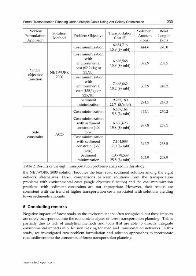
Table 2 summarizes the results of NETWORK 2000 and the ACO algorithm for the eight FTPP analyzed in this study. The four transportation problems formulated using the single objective function approach and solved using NETWORK 2000 show that the total amount of sediment decreases and the total transportation costs increase as the sediment goal is more heavily weighed. Compared with the cost minimization problem, the sediment minimization problem has a 40% cost increase, but the total sediment decreases by 34%. Similar results are found in the solution of the four transportation problems formulated using the side constraint approach and solved by the ACO algorithm. Transportation costs range from $15.8 to $25.5 per MBF in the cost and sediment minimization solutions, respectively, while the amount of sediment ranges between 306 and 445 tons. Total transportation costs increase and total sediment amounts decrease as the restriction level of sediment constraint increases (Table 2). The most cost-efficient transportation solution was found by NETWORK 2000, where the total transportation cost is $6,654,716. The ACO solution for the same problem (cost minimization) has a slightly higher total transportation cost of about 0.07%. In addition, the solutions from NETWORK 2000 and the ACO algorithm have the similar amount of total road sediments. For the sediment minimization problem, NETWORK 2000 also found a slightly better solution than the ACO algorithm. By producing only 294.5 tons of sediment,
www.intechopen.com
Forest Transportation Planning Under Multiple Goals Using Ant Colony Optimization
233
Problem Formulation
Approach
Solution Method
Problem Objective Transportation
Cost ($)
Sediment Amount
(tons)
Road Length
(km)
Cost minimization6,654,716
15.8 ($/mbf) 444.6 270.0
Cost minimization with
environmental cost ($2.2/kg or
$1/lb)
6,668,568 15.8 ($/mbf)
392.9 258.5
Cost minimization with
environmental cost ($55/kg or
$25/lb)
7,668,862 18.2 ($/mbf)
333.9 248.2
Single objective function
NETWORK 2000
Sediment minimization
9,285,180 22.7 ($/mbf)
294.5 247.3
Cost minimization6,659,164
15.8 ($/mbf) 445.1 270.2
Cost minimization with sediment constraint (400
tons)
6,666,625 15.8 ($/mbf)
397.8 259.1
Cost minimization with sediment constraint (350
tons)
7,164,888 17.0 ($/mbf)
347.7 258.5
Side constraint
ACO
Sediment minimization
10,778,539 25.5 ($/mbf)
305.9 248.9
Table 2. Results of the eight transportation problems analyzed in this study.
the NETWORK 2000 solution becomes the least road sediment solution among the eight
network alternatives. Direct comparisons between solutions from the transportation
problems with environmental costs (single objective function) and the cost minimization
problems with sediment constraints are not appropriate. However, their results are
consistent with the trend of higher transportation costs associated with solutions yielding
lower sediments amounts.
5. Concluding remarks
Negative impacts of forest roads on the environment are often recognized, but these impacts
are rarely incorporated into the economic analyses of forest transportation planning. This is
partially due to lack of analytical methods and tools that are able to directly integrate
environmental impacts into decision making for road and transportation networks. In this
study, we investigated two problem formulation and solution approaches to incorporate
road sediment into the economics of forest transportation planning.
www.intechopen.com

Ant Colony Optimization - Methods and Applications
234
The single objective function approach is relatively simple, and the existing transportation planning tools that were developed to minimize transportation costs, such as NETWORK 2000, can be used without modifications. However, it is a challenge to put a price on environmental impacts and select an appropriate environmental cost factor for predicted sediment yields. The second approach with side constraints can avoid this problem, but it may require more complex problem formulation and solution techniques, as well as a large solution time, to provide good quality solutions. Both NETWORK2000 and the ACO algorithm are based on heuristic solution techniques. Unlike MIP, such heuristic techniques do not guarantee the solution optimality, but they can be applied to large, real world transportation planning problems and provide feasible solutions in a reasonable amount of solution time. In addition, the problem formulation approaches and solution tools used in this study can be easily expanded to incorporate other environmental impacts into forest transportation planning. These tools can provide forest managers with environment-friendly road network alternatives that help them make informed decisions for their road management and planning. Further development of the ACO algorithm is suggested to enhance its performance and applicability as a generalized approach for solving large scale, real world FTPP with side constraints. First, the road attributes used to evaluate the transition probability associated with each edge could be standardized to a mean of zero and a variance of one. This would avoid the differences in magnitude of the attribute values affecting the evaluation of transition probability. Consequently a more homogenous weight can be given to each road attribute when predicting the goodness of a road segment in the solution. Lastly, as the solution quality is heavily dependent on the fine tuning of the algorithm parameter values, the incorporation of a sub-routine that dynamically determines the best parameter values during running time based on the problem size and range of road attribute values may be essential for facilitating the use of the ACO algorithm.
6. References
Adlakha, V. & Kowalski, K. (2003). A simple heuristic for solving small fixed-charge transportation problems. OMEGA: International Journal of Management Science, 31,3,205-211.
Bettinger, P. & Chung W. (2004). The key literature of, and trends in, forest-level management planning in North America, 1950-2001. International Forestry Review 6,1,40-50.
Contreras, M.; Chung, W. & Jones, G. (2008). Applying ant colony optimization metaheuristics to solve forest transportation planning problems with side constraints. Canadian Journal of Forest Research, 38,11,2896-2910.
Chung, W. & Sessions, J. (2003). NETWORK 2000: A Program for Optimizing Large Fixed and Variable Cost Transportation Problems. Proceedings of the 2003 Symposium on Systems Analysis in Forest Resources, Arthaud, G.J., & Barrett, T.M. (Eds), pp 109-120, Kluwer Academic Publishers.
Dijkstra, E. (1959). A note on two problems in connection with graphs. Numerische Mathematik, 1,269-271.
Dorigo, M.; Di Caro, G. & Gambardella, M. (1999). Ant algorithms for discrete optimization. Artificial Life, 5,2,137-172.
www.intechopen.com

Forest Transportation Planning Under Multiple Goals Using Ant Colony Optimization
235
Dorigo, M. & Di Caro, G. (1999). The ant colony optimization meta-heuristic. Proceeding on New Ideas in Optimization, Corne, D.; Dorigo, M. & Glover, F. (Eds), pp 11-31, McGraw-Hill, London, UK.
Dorigo, M. & Stützle, T. (2003). The ant colony optimization metaheuristic: Algorithms, applications, and advances. Handbook of Metaheuristics, Glover, F. & Kochenberger, G. (Eds.), pp 251-285, Kluwer Academic Publishers, Norwell, MA.
Elliot, W.J.; Hall, D.E. & Scheele, D.L. (1999). WEPP interface for predicting forest road runoff, erosion and sediment delivery. Technical Documentation WEPP: Road (Draft 12/1999). USDA Forest Service, Rocky Mountain Research Station and San Dimas Technology and Development Center [online]. Available from http://forest.moscowfsl.wsu.edu/fswepp/docs/wepproaddoc.html, Accessed 20 January 2008.
Falcao, A. & Borges, J. (2001). Designing an evolution program for solving integer forest management scheduling models: An application in Portugal. Forest Science, 47,2,158-168.
Greulich, F. (2003). Transportation networks in forest harvesting: early development of the theory [online]. In Proceedings International Seminar on New Roles of Plantation Forestry Requiring Appropriate Tending and Harvesting Operations, S3.04/3.06/3.07 Subject Area, IUFRO 2–5 October 2002, Tokyo, Japan. IUFRO, Vienna. Available from faculty.washington.edu/greulich/ Documents/IUFRO2002Paper.pdf [accessed August 20 2010].
Gottlieb, J. & Paulmann, L. (1998). Genetic algorithms for the fixed charge transportation problem. Proceedings of the 1998 IEEE International Conference on Evolutionary Computation, pp 330-335, IEEE Press.
Jones, G.; Weintraub, A.; Meacham, M. & Megendzo, A. (1991). A heuristic process for solving mixed-integer land management and transportation problems planning models. USDA Forest Service, Intermountain Research Station. Research Paper INT-447.
Kowalski, K. (2005). On the structure of the fixed charge transportation problem. International Journal of Mathematical Education in Science and Technology, 36,8,879-888.
Maniezzo, V.; Gambardella, M. & de Luigi, F. (2004). Ant colony optimization. New Techniques in Engineering, Onwubolor, G. & Babu, V. (Eds.), pp 101-117, Springer-Verlog, Berlin Heidelberg.
Martell, D.; Gunn, E. & Weintraub, A. (1998). Forest management challenges for operational researchers. European Journal of Operational Research, 104,1,1-17.
Olsson, L. & Lohmander, P. (2005). Optimal forest transportation with respect to road investments. Forest Policy and Economics, 7,3,369-379.
Rackely J. & Chung, W. (2008). Incorporating forest road erosion into forest resource transportation planning: a case study in the Mica Creek Watershed in northern Idaho. Transaction of the ASABE, 51,1,115-127.
Sessions, J.; Chung, W. & Heinimann, H. (2003). New algorithms for solving large-scale transportation planning problems. Workshop Proceedings: New Trends in Wood Harvesting with Cable Systems for Sustainable Forest Management in the Mountains, pp 253-258, Ossiach, Austria, June 2001.
Sessions, J. (1985). A heuristic algorithm for the solution of the fixed and variable cost transportation problems. In Proceedings of the 1985 Symposium on Systems Analysis in
www.intechopen.com

Ant Colony Optimization - Methods and Applications
236
Forest Resources, 9–11 December 1985, Athens, Georgia. P.E. Dress & R.C. Field (Eds), pp 324-336. University of Georgia, Athens, Ga.
Sun, M.; Aronson, J.; McKeown, P. & Drinka, D. (1998). A tabu search heuristic procedure for the fixed charge transportation problem. European Journal of Operational Research, 106,2-3,441-456.
Weintraub, A.; Jones, G.; Meacham, M.; Magendzo, A.; Magendzo, A. & Malchauk, D. (1995). Heuristic procedures for solving mixed-integer harvest scheduling-transportation planning models. Canadian Journal of Forest Research, 25,10,1618-1626.
Zeki, E. (2001). Combinatorial optimization in forest ecosystem management modeling. Turk Journal of Agriculture and Forestry, 25,187-194.
www.intechopen.com

Ant Colony Optimization - Methods and ApplicationsEdited by Avi Ostfeld
ISBN 978-953-307-157-2Hard cover, 342 pagesPublisher InTechPublished online 04, February, 2011Published in print edition February, 2011
InTech EuropeUniversity Campus STeP Ri Slavka Krautzeka 83/A 51000 Rijeka, Croatia Phone: +385 (51) 770 447 Fax: +385 (51) 686 166www.intechopen.com
InTech ChinaUnit 405, Office Block, Hotel Equatorial Shanghai No.65, Yan An Road (West), Shanghai, 200040, China
Phone: +86-21-62489820 Fax: +86-21-62489821
Ants communicate information by leaving pheromone tracks. A moving ant leaves, in varying quantities, somepheromone on the ground to mark its way. While an isolated ant moves essentially at random, an antencountering a previously laid trail is able to detect it and decide with high probability to follow it, thusreinforcing the track with its own pheromone. The collective behavior that emerges is thus a positive feedback:where the more the ants following a track, the more attractive that track becomes for being followed; thus theprobability with which an ant chooses a path increases with the number of ants that previously chose the samepath. This elementary ant's behavior inspired the development of ant colony optimization by Marco Dorigo in1992, constructing a meta-heuristic stochastic combinatorial computational methodology belonging to a familyof related meta-heuristic methods such as simulated annealing, Tabu search and genetic algorithms. Thisbook covers in twenty chapters state of the art methods and applications of utilizing ant colony optimizationalgorithms. New methods and theory such as multi colony ant algorithm based upon a new pheromonearithmetic crossover and a repulsive operator, new findings on ant colony convergence, and a diversity ofengineering and science applications from transportation, water resources, electrical and computer sciencedisciplines are presented.
How to referenceIn order to correctly reference this scholarly work, feel free to copy and paste the following:
Woodam Chung and Marco Contreras (2011). Forest Transportation Planning Under Multiple Goals Using AntColony Optimization, Ant Colony Optimization - Methods and Applications, Avi Ostfeld (Ed.), ISBN: 978-953-307-157-2, InTech, Available from: http://www.intechopen.com/books/ant-colony-optimization-methods-and-applications/forest-transportation-planning-under-multiple-goals-using-ant-colony-optimization

© 2011 The Author(s). Licensee IntechOpen. This chapter is distributedunder the terms of the Creative Commons Attribution-NonCommercial-ShareAlike-3.0 License, which permits use, distribution and reproduction fornon-commercial purposes, provided the original is properly cited andderivative works building on this content are distributed under the samelicense.