txdot surveyors’ conference · 2019-09-13 · txdot surveyors’ conference 2019 / 5 tuesday,...
TRANSCRIPT
TxDOT Surveyors’ Conference
2019 COMMITTEE ON GEOMATICS AND SURVEYING
25thAnniversary
2 / TxDOT Surveyors’ Conference 2019
Welcome
This is the 25th Anniversary of the Committee on Geomatics and Surveying (COGS) and the 22nd annual TxDOT Surveyors’ Conference and Workshop. Welcome to the conference, we hope this is a valuable experience for you.
COGS is working to make the annual conference more inclusive serving a larger portion of the geomatics community. This year we are pleased to announce the addition of a dedicated GIS track. COGS has partnered with the newly-formed GIS Workgroup (GISWG) to offer training and presentations on a wide range of topics relevant to Surveyors and GIS users across the agency.
The annual conference provides an ideal forum to meet, exchange ideas, share experiences, and to learn from experts. The presentations and exhibits allow participants to stay current on changing technologies, to increase professional knowledge, and to continue to improve the quality of surveying, geomatics, and GIS being done at the agency.
As with the 2018 conference, the 2019 conference will offer breakout sessions. Concurrent sessions allow for a greater variety of subject matter and more customized conference experience. As in the past, the surveying track content has been approved by the Texas Board of Profes-sional Land Surveyors for twelve hours of Continuing Education Unit (CEU) credits. In addition, many certification and credentialing programs recognize the conference presentations and activities as a source of educational and professional development credits.
COGS and GISWG members are here to serve and represent the survey-ing, geomatics, and GIS community within TxDOT. Your concerns are our concerns. Feel free to call on any member of COGS or GISWG to share your ideas on how to improve the committee, workgroup, and commu-nities. And remember that your feedback and input on this conference is essential. Please assist COGS and GISWG by providing your honest evaluation of the conference and share your ideas for future conferences.
Please enjoy the twenty-second annual TxDOT Surveyors’ Confer-ence and Workshop. Take time to get to know the person next to you and share your experience. And, thank you for making this confer-ence a success!
− David Dawson, COGS Chairman

TxDOT Surveyors’ Conference 2019 / 3
4 / TxDOT Surveyors’ Conference 2019
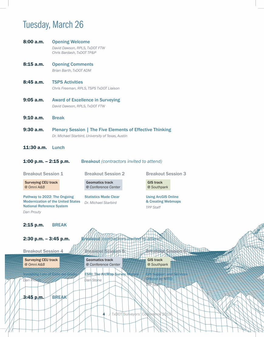
Tuesday, March 26
8:00 a.m. Opening WelcomeDavid Dawson, RPLS, TxDOT FTWChris Bardash, TxDOT TP&P
8:15 a.m. Opening CommentsBrian Barth, TxDOT ADM
8:45 a.m. TSPS ActivitiesChris Freeman, RPLS, TSPS TxDOT Liaison
9:05 a.m. Award of Excellence in SurveyingDavid Dawson, RPLS, TxDOT FTW
9:10 a.m. Break
9:30 a.m. Plenary Session | The Five Elements of Effective ThinkingDr. Michael Starbird, University of Texas, Austin
11:30 a.m. Lunch
1:00 p.m. – 2:15 p.m. Breakout (contractors invited to attend)
Breakout Session 1
Surveying CEU track @ Omni A&B
Pathway to 2022: The Ongoing Modernization of the United States National Reference System
Dan Prouty
Breakout Session 2
Geomatics track @ Conference Center
Statistics Made Clear
Dr. Michael Starbird
Breakout Session 3
GIS track @ Southpark
Using ArcGIS Online & Creating Webmaps
TPP Staff
2:15 p.m. BREAK
2:30 p.m. – 3:45 p.m. Breakout (contractors invited to attend)
Breakout Session 4
Surveying CEU track @ Omni A&B
Vanishing Lots of Callo del Grullo
Dan Prouty
Breakout Session 5
Geomatics track @ Conference Center
ESRI: The ArcMap Survey Module
Dan Stone
Breakout Session 6
GIS track @ Southpark
GIS Support and Services Offered by NTTD
TPP Staff
3:45 p.m. BREAK

TxDOT Surveyors’ Conference 2019 / 5
Tuesday, March 26
4:00 p.m. – 5:00 p.m. Breakout (contractors invited to attend)
Breakout Session 7
Surveying CEU track @ Omni A&B
TxDOT ROW Monument Preservation Project
Dan Erwin, RPLS
Breakout Session 8
Geomatics track @ Conference Center
TxDOT Real-Time Kinematic GPS Network Update
Matt Bryant
Breakout Session 9
GIS track @ Southpark
Contractor Information and Google Imagery – GIS Deliverable Guidelines, Metadata Standards, using Google Imagery in Arc and MicroStation
TPP Staff
5:00 p.m. Exhibit Hall Opens (Omni C,D,E,F)
8:30 p.m. Exhibit Hall Closes
6 / TxDOT Surveyors’ Conference 2019
Wednesday, March 27, 2019
8:00-9:45 a.m. Breakout (TxDOT only)
Breakout Session 10
Surveying CEU track @ Conference Center
Texas Professional Surveying Act and Rules Applied to Eminent Domain
Dr. Stacey Lyle
Breakout Session 11
Geomatics track @ Omni A&B
Data Extraction from Trimble SX10 Point Clouds
Sarah Gonzales
Breakout Session 12
GIS track @ Omni C
GIS Data Access – Open Data, Project Tracker, Statewide Planning Map, and AGO GRID and SLD Overview
TPP Staff
9:45 a.m. Break
10:00 a.m. – 11:45 a.m. Breakout (TxDOT only)
Breakout Session 13
Surveying CEU track @ Conference Center
Texas Board of Professional Land Surveying Rules and Act Review
Joe Breaux, RPLS
Breakout Session 14
Geomatics track @ Omni A&B
The Hyperspatial Frontier: Topographic Mapping with UAS Photogrammetry and LiDAR
Dr. Mike Starek
Breakout Session 15
GIS track @ Omni C
TPP Data Management Products and Their Use Cartography Basics
TPP Staff
11:45 a.m. Lunch
1:00 p.m. – 1:45 p.m. Breakout (TxDOT only)
Breakout Session 16
Surveying CEU track @ Conference Center
Parcel Acquisition
Lora Gunter
Breakout Session 17
Geomatics track @ Omni A&B
The Utility Engineering and Surveying Institute (UESI)
Jesse Cooper
Breakout Session 18
GIS track @ Omni C
Scripting in Arc and Python Basics
TPP Staff
1:45 p.m. Break

TxDOT Surveyors’ Conference 2019 / 7
Wednesday, March 27, 2019
2:00 p.m. – 3:00 p.m. Breakout (TxDOT only)
Breakout Session 19
Surveying CEU track @ Conference Center
Land Grants and Surveying in Spanish and Mexican Texas
Brian A. Stauffer, Ph.D.
Breakout Session 20
Geomatics track @ Omni A&B
Extract-Translate-Load Models: DGN to GeoDB and TxDOT Bridges and Roads in 3D Gaming Engines
Dr. Stacey Lyle
Breakout Session 21
GIS track @ Omni C
STARS and Leveraging GIS for Traffic Data Analysis
TPP Staff
3:00 p.m. Break
3:20 p.m. Closing Session 1Leap Forward with TxDOTConnectErika Kemp, TxDOT MPPM
4:10 p.m. Closing Session 2Comparing UAS to Manned Aircraft for MappingJonathan Martin, TxDOT DES

8 / TxDOT Surveyors’ Conference 2019
The Committee on Geomatics and Surveying (COGS)
ObjectiveThe primary objective of the committee is to provide guid-ance to administration to achieve the goal of providing efficient, effective, and affordable geomatics services and projects to users within the agency and to:
• Be an effective committee,
• Maintain expertise in geomatics,
• Provide the annual TxDOT Geomatics and Surveying Conference and Workshop,
• Provide the agency with guidance in geomatics,
• Provide liaison to the TBPLS, TSPS, and other profes-sional geomatics organizations,
• Provide liaison to TxDOT contractors,
• Maintain standards and specifications.
Mission Statement• Make TxDOT a more effective organization by evaluat-
ing and recommending adoption of technologies and techniques that are cost effective, improve efficiencies, and improve quality.
• Make TxDOT a safer organization by evaluating and recommending adoption of technologies that improve employee safety by minimizing exposure to hazard-ous working conditions
• Make TxDOT transportation infrastructure last longer by evaluating and recommending adoption of technologies and techniques that improve pavement condition assess-ment, improve bridge clearance measurements, and improve general measuring quality.
• Help TxDOT meets its mission by providing expertise in the geospatial resources fundamental to the success of the agency.
Committee Membership• Five member seats from districts,
• One standing seat from the ROW Division,
• One standing seat from the Design Division,
• One standing seat from the Photogrammetry Section,
• One standing seat from the Construction Division,
• One standing seat from the Informa-tion Management Division,
• One standing seat from the Transportation Planning and Programming Division,
• One at-large seat from another non-represented divi-sion or district.
Membership Terms• Member terms are five years in length,
• Standing terms do not expire,
• At-large term is three years in length.
Leadership / Administration• The committee is sponsored by the ROW Division
• The committee is led by a chairman, elected annually by a majority vote of the committee membership,
• Meetings are conducted on a quarterly basis or more frequently if needed,
• Meeting summaries document the business conducted during committee meetings.
Meeting ScheduleMarch 26-27, 2019 | 2019 TxDOT Surveyors’ Conference
March 28, 2019 | 2019 TxDOT Surveyors’ Workshop
June 14, 2019 | General Business Meeting
August 16, 2019 | General Business Meeting
November 15, 2019 | General Business Meeting
January 17, 2020 | General Business Meeting
Committee MembershipMEMBER
DISTRICT/DIVISION
TERM EXPIRES
Tim Wright DAL 2020
Scott Morris, RPLS LFK 2021
David McDow, RPLS, LSLS TYL 2022
Randall Kircher, RPLS CRP 2023
Manuel Carrizales, RPLS PHR 2024
Dan Erwin, RPLS ROW Standing Term
Brent Eastman IMD Standing Term
Jonathan Martin, CP DES Standing Term
Arturo Perez, PE CST Standing Term
Travis Scruggs TP&P Standing Term
Sandra Sinton, PE DES Standing Term

TxDOT Surveyors’ Conference 2019 / 9
GIS Workgroup (GISWG)
Goals & ObjectiveThe role of the GIS Workgroup is to represent the GIS community at TxDOT. The Workgroup helps guide the long-term GIS strategy for the agency, recommends projects and datasets that accomplish those goals, and coordinates between GIS stakeholders, both internally and externally.
• Establish GIS standards for the department,
• Develop a GIS Governance Policy,
• Establish a GIS inventory,
• Recommend long-term strategy for GIS,
• Recommend projects to accomplish goals,
• Facilitate cooperation between GIS stakeholders and external partners.
Committee MembershipMembers are appointed by their respective DE/DD from business units within TxDOT that maintain or produce GIS data, or technical business units that will need to interface with GIS data,
• Three member seats from districts, representing metro, urban, and rural districts,
• One member from each applicable division.
Membership Terms• Members serve 2 year terms,
• Terms are staggered by one year.
Leadership / Administration• The committee is sponsored by Brian Barth,
• The committee is led by co-chairs Chris Bardash (TPP) and Wayne Vore (IMD).
Meeting ScheduleThe GIS Work Group meets on the second Tuesday of each month, between 2pm and 4pm in TPP Conference Room A, 118 E. Riverside Dr.
Committee MembershipMEMBER
DISTRICT/DIVISION
TERM EXPIRES
Chris Bardash TPP 4/2020
Wayne Vore IMD 4/2020
Andy Martinez TYL 4/2019
Sophia Bradford AVN 4/2020
Jenny Li MNT 4/2019
Dan Erwin ROW 4/2020
Alisha Pena MRD 4/2019
Larry Stokes PTN 4/2020
Sarah Berryhill TRV 4/2019
Larbi Hanni TRF 4/2020
Ashley Hayes ODA 4/2019
Meredith Lovelace AUS 4/2020
Jason Kord ENV 4/2019
Jeffrey Cuevas BRG 4/2020
Pete Krause DES 4/2019
10 / TxDOT Surveyors’ Conference 2019
Stephen R. Schmidt Award of Excellence in Surveying
Stephen R. Schmidt AwardTxDOT’s Stephen R. Schmidt Award of Excellence in Surveying is awarded to recognize an individual in the TxDOT surveying, mapping, photogrammetry, construction or contract management community who has exhibited outstanding service to TxDOT and/or the surveying profes-sion. In addition to their service and contributions to TxDOT and/or the surveying profession, award winners are recog-nized as good and valuable citizens in their communities.
This annual award, first awarded in 2010, is named for Stephen R. Schmidt, who faithfully served TxDOT for 20 years as an expert in the areas of GPS surveying. Award recipients are selected by the Committee on Geomatics and Surveying (COGS) from nominations submitted by TxDOT supervisors, coworkers, and peers.
Past recipients2018 Ivor Walker, RPLS
2017 Michael Shelton, RPLS
2016 David Crain, RPLS, LSLS
2015 Darryl Zercher, RPLS
2014 Randall Kircher, RPLS
2013 Wayne Ekdahl, PE, RPLS
2012 Richard Hutton, RPLS
2011 Joseph L. Grimes, Jr.
2010 Stephen R. Schmidt, CST
TxDOT Surveyors’ Conference 2019 / 11
TxDOT Committee on Geomatics and Surveying Members
Manuel Carrizales, RPLS
Manuel “Manny” Carrizales started his career in the private sector in 1997 having just completed a 5 year active duty enlistment in the United States Army where he earned the rank of Special-ist, E4 Promotable.
He earned an associate’s degree in Computer Aided Drafting and Design from ITT Tech, San Antonio and worked as a draftsman. Knowing he could achieve more, he used his enlistment
benefits to get himself through college while raising a family and work-ing full time in a private Civil Engineering firm.
After many years of applying himself, he earned a degree in Manufac-turing Engineering from the University of Texas Pan American in 2006, the same year he earned his status as an Engineer-In-Training, having passed his FE exam as well as his Surveyor-In-Training status, having passed his FS exam.
Manny earned his RPLS in 2012. He has been very active in the survey-ing community where he is known by his peers throughout the state. Manny was awarded the TSPS Chapter President of the Year Award as well as the Star Chapter of the Year Award in 2013. In 2017 he was awarded the prestigious Young Surveyor of the Year Award. Manny started working for TXDOT in the Pharr District in April 2018.
Brent Eastman
Brent Eastman is a Program Manager in the Strategy & Portfolio Management Division (IMD). In this role, Brent leads the Business Capabilities team, charged with partnering with TxDOT business units to develop strategies and prioritize projects that use technology and infor-mation sharing to improve TxDOT’s capabilities to serve the public.
Brent joined TxDOT in August 2015. He brings more than 15 years of project management experience and holds the Project Management Professional (PMP) Certification.
Prior to TxDOT, Brent worked more than six years at the U.S. Depart-ment of State in Washington, DC managing international projects and building relationships with multiple stakeholders. Brent has also served as a Project Manager in the private and non-profit sectors.
Brent holds a Masters of Public Administration degree and an MA in International Relations from the Maxwell School of Syracuse University and a BA in International Studies from American University.
Dan Erwin, RPLS, PLS
Daniel L. “Dan” Erwin is a right of way surveyor, geographic information systems (GIS) specialist, and GIS coordinator in the TxDOT ROW Division’s Asset Management Section.
Dan started his surveying career in the Lower Rio Grande Valley in 1967. He has a total of 49 years of experience of which 22 years are in private sector surveying.
Dan has held the position of cadastral surveyor and survey examiner with the Bureau of Land Management, United States Department of the Interior in Santa Fe, New Mexico (1978-1984), the TxDOT district survey coordinator of the Austin District (1986-1990),
and the TxDOT district survey coordinator of the El Paso District (2000-2006). He transferred to the TxDOT ROW Division in 2007.
Dan received his certification as a Registered Professional Land Surveyor in Texas in 1986 and his certification as a professional land surveyor in Wyoming in 1999.
Randall Kircher, RPLS
Randall Kircher is the Corpus Christi District Survey Coordinator, managing Survey, Subsur-face Utility Engineering (SUE), and Utility Accom-modation, Coordination & Verification (UAVC) consultants, and managing the district’s survey personnel, data and resources.
He began his career with TxDOT in 1990 in the Corpus Christi Area Office as a survey crew member and moved to the District Survey Office
in 1995, managing district survey consultant projects and monitoring quality control of survey deliverables. He became a Registered Profes-sional Land Surveyor in May of 2002.
Randall began serving his second term on COGS in 2017, having previ-ously served from 2007-2011, including as chair from 2009-2011. He was awarded the Stephen R. Schmidt Award of Excellence in Surveying in 2014, and has been a member of the Texas Board of Professional Land Surveying Quality Assurance/Quality Control (QA/QC) Exam Committee since 2006, and serves as QA/QC Committee Secretary.
Randall was raised on a farm, and owns and runs a small farming operation in his spare time. He enjoys spending time with his wife, Christine, visiting their daughters, Amy and Julie, and following college football and baseball.
Jonathan Martin, CP
Jonathan Martin is a Certified Photogrammetrist working in the Design Division. Jon has over 35 years’ experience in the geospatial sciences including photogrammetry, land surveying Geographic Information Systems (GIS), and Global Positioning Systems (GIS).
Jon is the technical lead for the current TxDOT research into the use of unmanned aerial systems (UAS). He serves on the COGS Technol-
ogy and Conference subcommittees.
Jonathan graduated from the University of Texas at Austin and is an active member of the American Society for Photogrammetry and Remote Sensing.
David A. McDow, RPLS, LSLS
David A. McDow is the Tyler District Survey Coordinator, responsible for reviewing consultant deliverables, managing all District surveying oper-ations, overseeing two in-house surveying crews, developing District procedures and standards, and answering questions from the public.
David began his surveying career as a tail-chain-man in 1983 in Austin, TX, with Jeryl Hart Engi-neers, Inc. During the late 1980s/early 1990s
the Texas economy caused David to hide in college. He obtained a BA and MA in Anthropology from the University of Texas at Austin with the

12 / TxDOT Surveyors’ Conference 2019
TxDOT Committee on Geomatics and Surveying Membersgoal of becoming a professor and doing research. Realizing in the late 1990s that his objective was a fantasy, David returned to surveying.
In 2000 David started with Cunningham Allen, Inc., an engineering and surveying firm in Austin, TX. David became a Registered Professional Land Surveyor in June of 2006.
David took the opportunity to work at the Texas General Land Office (GLO) in 2007 where he became a Licensed State Land Surveyor in July of 2011. David worked at the GLO until October 2015.
David began his career with TxDOT in the Bryan District October 2015 and started at the Tyler District in January of 2018. David was appointed by the Texas Board of Professional Land Surveying to the Quality Control/Quality Assurance (QCQA) Examination Committee August 2007. David was appointed as the Vice-Chairman of the QCQA Committee October 2014.
David was born to and grew up in a ranching family in Falfurrias, TX. He has been married to Lisa for 34 years and has one daughter, Sarah. David loves backpacking with his family in the mountains of New Mexico, Utah, and Arizona. He also loves spelunking with Sarah in various locali-ties in Texas and other states.
Scott Morris, RPLS
Scott Morris is the district survey coordinator for the TxDOT Lufkin District.
He began his career with TxDOT as a summer hire in 1982 in the San Augustine County Mainte-nance Office of the Lufkin District.
Morris worked several summers for the state before graduating from Tyler Junior College with an Associates of Applied Science in Surveying.
He spent the next 25 years in the private sector performing boundary surveys in east Texas and then as a consultant surveyor for transportation projects.
In 2012, he returned to TxDOT where he holds his current position.
His interests outside of surveying include playing competitive bridge, gold, and spending time with his wife and two daughters.
Arturo Perez, PE
Arturo Perez joined TxDOT in 2002 as a summer hire with the Traffic Materials Branch in the Construction Division. He has 15 years’ experi-ence in material testing, forensics, and instru-mentation development with TxDOT.
Prior to TxDOT, he worked for Motorola’s Advanced Products Research and Development Lab (APRDL) while earning a BS degree in Physics from the University of Texas at Austin.
In December 2012 he became a Registered Electrical and Computer Engineer; in July of 2016, he became a certified Level 1 Thermogra-pher; and in October of 2016, he became certified in VZ-400i Operation & Processing (LiDAR scanning).
Although he has not piloted an aircraft in more than 25 years, he has a Pilot’s License in visual flight rules, single-engine land, obtained in summer of 1998.
Currently, Arturo works on special projects and research involving remote sensing applications, material-infrastructure characteriza-tion, and forensics.
Travis ScruggsTravis Scruggs is a GIS Analyst in the Data Management Section of TxDOT’s Transportation Planning and Programming Division and has been at TxDOT for 10 years.
Travis has worked to create and maintain TxDOT’s spatial roadway data, manage GIS projects and data, and coordinate the efforts of GIS users both within TxDOT and with other State Agen-cies. Travis also serves as a project advisor on multiple Research and Technology Implementa-
tion Division (RTI) projects studying the impacts and future development paths for connected and autonomous vehicles.
Travis received a Bachelor’s degree in Geography in 2007 and a Master’s degree in Geospatial Sciences in 2009, both from the Univer-sity of Texas at Dallas. Travis is passionate about autonomous vehicles, rocketry and space science.
Sandra Sinton
Sandra Sinton is a Transportation Engineer in the Design Division.
Sandra has 20 years of experience with TxDOT. She works in the Plan Development Section where she has recently designed and managed various energy sector projects for the Odessa District. She is currently assisting with the test-ing and implementation of the new OpenRoads Designer for the department.
Sandra graduated from the University of Texas at Austin with a Bachelor of Science in Mechanical Engineering. She grew up in Victoria, TX. She and her husband, Alan, have been married for 18 years and have two sons, Daniel and Grayson. Sandra loves spending time with her family and friends.
Tim P. Wright
Tim P. Wright began his career with TxDOT in 2001 as a design technician for the Dallas District Survey Office.
He served as the Geographic Information Systems (GIS) coordinator for the district for several years while working towards his field and office experience to obtain his Surveyor-in-Train-ing (SIT) certification and Registered Professional Land Surveyor (RPLS) license.
Prior to obtaining his licensing, he accepted a position in the Advanced Project Development Office as a NEPA writer and public information coordinator.
He returned to surveying in 2014 and is currently pursuing his RPLS.
Wright earned his Bachelors of Science degree in geography, cartog-raphy, and Geographic Information Systems in 200 from Texas State University in San Marcos.
Tim passed his SIT exam in 2006. He currently supervises the Right of Way and Design Mapping Section for the Dallas District.

TxDOT Surveyors’ Conference 2019 / 13
Speaker Profiles
Brian BarthBrian R. Barth is the Director of Project Planning and Development for the TxDOT, responsible for overseeing the Transportation Planning and Programming, Right of Way, Environmental Affairs, Professional Engineering Procurement, and Transportation Programs divisions.
A member of the TxDOT family since 1988, Barth began his career as an engineering assistance in the Dallas District after graduating from the University of Texas at Austin with a bachelor’s
degree in civil engineering. In 2003, Barth was appointed as the Dallas District’s director of transportation planning and development. From 2009 to 2013, Barth served as the Fort Worth District’s deputy district engineer, providing joint oversight and development of the DFW Connec-tor, North Tarrant Express, I-35W, I-30, and Chisholm Trail Parkway.
Barth was appointed as Fort Worth district engineering in 2013, and served on the Regional Transportation Council of the North Central Texas Council of Governments working to solve Metroplex-area transpor-tation issues. Under Barth’s direction as district engineer, he also over-saw over $1 billion in construction work each year in addition to major projects on I-35W, SH 360 South, and the I-30/SH 360 interchange.
A sports enthusiast, Barth is a devoted fan of the Texas Longhorns, Dallas Mavericks, Texas Rangers and Dallas Cowboys in addition to playing intramural basketball and softball. He and his wife, Brenda, are happily married and live in Flower Mound with daughter, Brianna.
Chris FreemanChris Freeman is the survey program manager at Lina T. Ramey & Associates, Inc., in Dallas. He has held this position since 2012.
He is an active member of the Texas Society of Professional Land Surveyors (TSPS), having served in a variety of capacities at both the chap-ter and state levels since 1984.
Freeman serves as chairman of the TSPS TxDOT Liaison Committee. He also serves on the State
Governmental Affairs Committee, State Membership Committee, State Public Relations Committee, and as the north area representative.
Michael Starbird
Michael Starbird is a University Distinguished Teaching Professor of Mathematics at The Univer-sity of Texas at Austin.
He has been at UT his whole career except for leaves, including to the Institute for Advanced Study in Princeton, New Jersey and the Jet Propulsion Laboratory in Pasadena, California.
He has received more than fifteen teaching awards including the Mathematical Association
of America’s 2007 national teaching award, the Minnie Stevens Piper Professor statewide award, the UT Regents’ Outstanding Teaching Award, and most of the UT-wide teaching awards. He has given hundreds of lectures and dozens of workshops on effective teaching and effective thinking.
He has produced DVD courses for The Teaching Company in the Great Courses Series on calculus, statistics, probability, geometry, and the joy of thinking.
He co-authored, with Edward Burger, the textbook The Heart of Math-ematics: An Invitation to Effective Thinking and has co-authored two Inquiry Based Learning textbooks.
He produced an edX MOOC (Massive Open Online Course) titled Effective Thinking Through Mathematics. His recent book with co-author Edward Burger is The 5 Elements of Effective Thinking.
Dan ProutyDaniel Prouty is the Southern Plains Regional Geodetic Advisor for NOAA’s National Geodetic Survey since 2009. Mr Prouty received a PhD and MS in Ocean Engineering from Southamp-ton University, United Kingdom in 2007. He also has an MS degree in Computer Science and a BS degree in Geology from Texas A&M Corpus Christi.
Davey Edwards
Davey Edwards is a 6th generation Texan and a professional land surveyor in Texas and Okla-homa. He also has been duly qualified as a Texas licensed state land surveyor and a U.S. Federal land surveyor. He is currently a professional assistant professor in the Geographic Informa-tion Sciences and Geospatial Systems Engineer-ing program at Texas A&M University in Corpus Christi. He has been appointed director of the Texas Spatial Reference Center in the Conrad
Blucher Institute for Surveying and Science.
Davey has his bachelor’s degree in biomedical science from Texas A&M University in College Station, master’s degree in geospatial surveying engineering from Texas A&M University in Corpus Christi, and doctorate degree in geosciences from the University of Texas in Dallas. His studies concentrated on land administration systems and riparian boundary morphology.
Davey teaches various professional continuing education courses on land surveying. He was an adjunct professor in geology at Weatherford College Wise County. He has served on the advisory committee for the geospatial surveying engineering program at Texas A&M University
– Corpus Christi.
Davey is a past president of the Texas Society of Professional Survey-ors. He has served as Governor Rick Perry’s appointee as public member of the Texas Board of Architectural Examiners and is currently serving as Governor Greg Abbott’s appointee as a licensed state land surveyor member of the Texas Board of Professional Land Surveying. He is the 2006 recipient of the TSPS Young Surveyor of the Year award and the 2007 recipient of the TSPS Chapter President of the Year award.
Davey continues to be the vice president of his father’s 40-year old land surveying company, Edwards Surveying, LLC, in Decatur, Texas, where their primary work is in large boundary surveying and boundary issue resolution. His work has been on some of the most complex original land grant surveys for the Texas General Land Office. He has surveyed, on-the-ground, in every region of Texas and Oklahoma. He had served as chairman of the City of Decatur’s planning and zoning commission.
Recently, he has taken up the effort to educate the public on the importance of land administration systems to protect private and public property rights, especially in Texas. Davey has been touring the State of Texas speaking at town hall meetings on this subject. He has volun-teered with U.S. Congressman Mac Thornberry in Washington D.C. and Governor Greg Abbott and Texas Attorney General Ken Paxton to defend the property rights of land owners along the Red River against claims by the U.S. Bureau of Land Management.

14 / TxDOT Surveyors’ Conference 2019
Speaker Profiles
Matt Bryant
Matthew has worked over 30 years working the Surveying and Geospatial industry. He has directly supported TxDOT over 20 years, 5 of which working for TxDOT’s Information Systems Division (now IMD) providing training and support for Surveying and GIS.
He worked directly with TxDOT construction contractors automating construction processes and introducing enterprise solutions with new
technology to some of the largest construction companies in Texas.
Currently Matt is the Delivery Manager for NTT Data TxDOT Survey and RTN Support group.
Stacey Lyle
Dr. Stacey D. Lyle, RPLS is Assistant Professor of Practice in the College of Geosciences.
He is a former NASA and USDA Fellow, Profes-sional Land Surveyor, and he has 30 years of experience in developing Geospatial Technolo-gies for BP American Production Company, Leica Geosystems, NASA, NOAA, National Geodetic Survey, National Geospatial Intelligence Agency, US Army Corps of Engineers, Texas General Land
Office, and others.
He has New Technology Patents with NASA and has launched a return to Earth Payload Rocket with NASA. Dr. Lyle has built collabo-rative teams to utilize geospatial technologies to transform the way we work to reduce our impact on the Earth while bringing energy to humans most efficiently.
Sarah Gonzales
Sarah Lewis-Gonzales is a Remote Sensing Technician & Trainer with NTT Data Services with nine years of remote sensing, GIS, classification, and accuracy assessment experience.
Sarah holds a Bachelor of Science degree in Geography from Texas Tech University. She has a Master of Science in Geography from the University of Tennessee with specialty in remote sensing, classification methods,
and accuracy assessment.
Sarah has eight years of teaching experience in remote sensing and geospatial applications, including development of training material for professionals with the NASA Develop program.
Stephanie Marquez
Stephanie Marquez, BSME is an Engineering Services Delivery Manager with NTTD Services. She has 15 years of experience in civil and struc-tural engineering with a focus in remote sensing for three-dimensional modeling.
Stephanie’s experience extends to design, field data collection, project management, and enter-prise administration for local, state, and federal government contracts as well as oil, gas, mining,
environmental, and utility clients.
W.J. (Joe) Breaux, RPLS
Joe is the District Survey Coordinator for the TxDOT Bryan District.
He began his TxDOT career in 1999 as the Survey Coordinator; first in the Beaumont District, then in the Austin District. His prior experience includes 25 years in the private sector with consulting engineering and surveying firms.
Joe graduated from Texas A&M University with a degree in Engineering Technology-Surveying. He
earned his license as a Registered Professional Surveyor in 1984. As a member of the Texas Society of Professional Surveyors, he is a Director on the TSPS State Board and Chair of the Education sub-committees of Safety and Course/Speaker Development.
Joe is a TSPS certified course developer, co-author, and speaker for several TSPS education courses approved for CEU credits as well as part of several other course development teams. He is past president of the TSPS Deep East Texas Chapter 6 and presently a member of Brazos Valley Chapter 20. Joe is a past recipient of the TSPS Vern Wayne Hanan Memorial Community Action Award.
Michael (Mike) Starek
Dr. Michael “Mike” J. Starek is an Associate Professor in Geospatial Systems Engineering at Texas A&M University-Corpus Christi (TAMU-CC) and Director of the Measurement Analytics (MANTIS) Lab with the Conrad Blucher Institute for Surveying and Science.
Starek holds a Ph.D. in Civil Engineering from the University of Florida and was formerly a National Research Council Postdoctoral Fellow of the U.S.
Army Research Office in affiliation with North Carolina State University.
His research focuses on the merging of geomatics, remote sensing, and geospatial computing for precise measurement and analysis of natural and built environments. Starek has co-authored over 35 publi-cations and 100+ conference abstracts in geomatics centric topics including lidar, unmanned aircraft systems, digital terrain modeling, and coastal geomatics.
TxDOT Surveyors’ Conference 2019 / 15
Speaker Profiles
Lora GunterLora Gunter, J.D., SR/WA, CTCM is the Project Delivery Director for the Right of Way Division of the Texas Department of Transportation (TxDOT).
In her role, she oversees the department’s statewide right of way acquisition portfolio and implements the policies and procedures for right of way project delivery activities.
Lora’s right of way career began in 2001 when she served as an Assistant Attorney General
representing TxDOT in eminent domain matters across the state. She has been in various other roles at TxDOT and has also has worked in the private sector representing large public utility companies in condem-nation proceedings and other right of way issues.
Jessie Cooper, RPLSJessie is a Senior Utility Project Manager with HDR Engineering providing Utility Adjustment Coordination with 30+ years of project admin-istration, surveying, coordination, QA/QC and project controls experience.
He has a Bachelor of Science in Civil Engineering from Texas A&M University and is a Registered Professional Land Surveyor (No. 5110). His career has centered on all aspects of utility coordination/utility engineering/utility relocation/
surveying/SUE/ utility adjustment inspection.
Jesse has provided leadership for the HDR team on Projects such as the Rapid Bridge Replacement Project in Pennsylvania for the utility relo-cation analysis of over 500 bridges, update of the North Carolina Utility Manual and preparing Utility Training Materials for South Carolina. As the former TXDOT Section Director of the Map, Survey, & Utility Section, Jesse provided oversight of the Mapping/Surveying Program and the Utility Program relocating utilities for transportation projects.
He also served on the TxDOT Committee for Geomatics and Surveying. He was part of the team presented the FHWA 2006 Utility Outstanding Achievement Award in the Category of Utility SUE (Subsurface Utility Engineering) and the 2003 Streamlining and Innovation Honor-able Mention Award.
Brian Stauffer
Brian A. Stauffer is a native of Afton, Wyoming. He holds a Ph.D. in Latin American History from the University of Texas at Austin and an M.A. in Latin American History from the University of New Mexico.
His research focuses on the religious and agrar-ian history of Mexico and Mexican Texas in the nineteenth century. His book on armed Catholic rebellion in 1870s Michoacán will be published
by the University of New Mexico Press in late 2019. Other published work includes a book chapter on the privatization of indigenous commu-nal lands in nineteenth-century Michoacán and an article on Catholic globalization and Mexico’s “spiritual pilgrimage” of 1874.
Since July 2016, he has served as the Translator and Curator of the Spanish Collection at the Texas General Land Office, where he is devel-oping new projects on slavery, religious cartography, and the religious aspects of empresario colonization in Texas.
Erika Kemp
Erika Kemp, PMP, CTCM, serves as the leader of the Transportation Programs Operations and Reporting Section within the Transpor-tation Programs Division responsible for the Modernize Portfolio and Project Management (MPPM II) Initiative.
In addition to reporting and enterprise gover-nance, Erika oversees the planning and imple-mentation of a complex technological initiative
that is expected to replace up to 40 systems and impact over 6,500 internal TxDOT employees as well as thousands of external partners. This long-term and enterprise-wide initiative will implement TxDOT-CONNECT as the one-stop shop for transportation program /portfolio management, project lifecycle, and right of way.
Erika has more than 20 years of diverse project management experi-ence leading large projects in the transportation and telecom industries, including a 16-year career at AT&T where she was Vice President and General Manager for the Virginia and West Virginia area.
Erika earned her bachelor’s degree in business administration from South University. She is a registered Project Management Professional (PMP) and a Certified Texas Contract Manager (CTCM).
TP&P Staff Presenters• Chris Bardash
• Chris Didear
• Cody Leitholt
• Eric Kinsey
• George Sosa
• Jennifer Bierman
• Jeremy Rogers
• Jessica Lane
• Joseph Campbell
• Laura Roedl
• Matthew Washburn
• Richard Barrientos
• Sam Bogle
• Tom Neville
• Travis Scruggs

16 / TxDOT Surveyors’ Conference 2019