trăsăturile morfografice şi morfometrice ale dobrogei de sv
TRANSCRIPT

Carpathian Journal of Earth and Environmental Sciences, October 2010, Vol. 5, No. 2, p. 25 - 38
ECOLOGIC CHARACTERIZATION OF THE FLUVIATILE LIMANS IN THE SOUTH-WEST DOBRUDJA AND THEIR ECONOMIC
IMPLICATIONS (ROMANIA)
Gheorghe T. ROMANESCU1, Cristina I. DINU2, Adina L. RADU3 & Liliana I. TÖRÖK4
1.University “Al.I.Cuza” of Iasi, Faculty of Geography and Geology, Department pf Geography, Bd.Carol I, 20A, 700505, Iasi, Romania, Tel.0040 744774652, Fax.0040 232 201481, e-mail: [email protected]; [email protected].
2.Eco-Museal Research Institute Tulcea, Danube Delta Ecotouristic Center, 14 Noiembrie, no.1, 820009, Tel./fax + 40 240 515866, e-mail: [email protected], www.3d-center.ro.
3. Eco-Museal Research Institute Tulcea, Danube Delta Ecotouristic Center, 14 Noiembrie, no.1, 820009, Tel./fax + 40 240 515866, e-mail: [email protected], www.3d-center.ro.
4. Danube Delta National Institute for Research and Development, Babadag no.165, 820112 Tulcea, Tel. + 40 240 524546, Fax: + 40 240 533 547, e-mail: [email protected], www.indd.tim.ro.
Abstract: The altimetric and granulommetric proofs, as well as their shape, include them in the category of typical fluviatile limans from this point of view. The four analysed lakes contain fresh water with a higher mineralization than the Danube. The increase of concentration corresponds to the periods in which the connection with the river is interrupted. The marshes Vederoasa and Iortmac have a higher salt content due to underground supply. Due to its chemical properties, the water of all marshes are included in the class of bicarbonated waters – calcium group, when they are supplied by the Danube, or sodium group, when the connection with the river is interrupted and a chemical metamorphosis process takes place (Bugeac, Oltina, Dunareni marshes), or magnesium group when water supply comes from own sources (Vederoasa, Iortmac and Baciu marshes). The structure of vegetation in the lacustrine cuvettes included five aquatic associations and four swamp associations. The lakes vegetation cover degree has percentages between 10-90%. The greatest plankton amount is found at the junction between the lakes and the supply channels coming from the Danube. The reduced species diversity reflects the answer of the fish population to the changes of the environmental conditions.
Key words: fluviatile limans, evolution, ecology, fishing industry.
1.INTRODUCTION
As these fluviatile limans were interpreted to have other origins along time, we have tried, by offering geomorphologic proof, to demonstrate that their origin is not marine or lacustrine, but purely fluviatile. This thing is important for the continuity of the fluviatile life within this aquatic biotope.
At the same time, special attention was given to the evolution of the lacustrine cuvette through the geomorphologic processes occurring here and influencing water quality.
Only the big size and the economically important lakes were considered: Bugeac (Gârlita), Oltina, Dunareni (Mârleanu) and Vederoasa. Bugeac Lake, also known as Gârlita, Oltina lake included
another enclosure known as Iortmac, Dunareni lake, known as Mârleanu, has in its upstream cuvette a small size lake known as Beilic and Vederoasa lake has, in its north-eastern sector another small size cuvette known as Baciu. Within each cuvette, several collecting stations have been chosen, according to the importance of the place.
In order to define the quality of the lacustrine waters, measurements have been taken on the physical parameters (depth, transparency, temperature) and chemical parameters (pH, O2, PO4
3-, P, NO3-, NH4
+, Ca/Mg). A synthetic table regarding the most important
parameters defining water quality was done, and then, a global analysis of the main lacustrine cuvettes was done. In order to do this, complete
25

analysis on the nature of the plankton (phytoplankton, zooplankton), on vegetation, zoo-benthos, amphibians, reptiles, ichtio-fauna, avifauna and mammals was done. The most thorough interpretations referred to the connection between the physical-chemical parameters of waters and the existence of the plankton, especially in the cuvettes used for fish breeding in particular.
At the same time the eutrophization degree of the lacustrine waters is monitored and the preservation of this aquatic units in order to use them intensely for different purposes: fish industry, irrigations, recreational etc.
To detail the studies conducted in the fluviatile limans situated in the south-west of Dobrudja (Romania) was consulted a large body of Romanian, European and American domain literature, from which have been extracted the most important directions and ideas to be reported to the local realities: geomorphology and hydrology (Murgoci, 1957, Popescu-Gorj & Costea, 1961, Mihailescu, 1966, Tufescu, 1966, Rozycki, 1967, Basarabeanu, 1969, Cotet, 1969, 1978, Iancu & Iana, 1969, Conea, 1970, Gastescu, 1971, Airinei, 1980, Popovici et al., 1984, Dussart & Defaye, 1995, Romanescu, 1995, 2003, Romanescu & Jigau, 1998, Lacatusu, 2000, Aerni, 2004, Dinu & Radu, 2004, Sallenare & Cowley, 2004, Dinu et al., 2005, Dodds & Cole, 2007, Füzesi, 2007, Cabezas et al., 2008), chemistry and biology (Kieffer, 1960, Rudescu, 1960, Popescu-Gorj & Costea, 1961, Damian-Georgescu, 1963, 1966, Iancu & Iana, 1969, Harding & Smith, 1974, Negrea, 1983, Krammer & Lange, 1986, 1988, 1991a, 1991b, Dussart & Defaye, 1995; Vadineanu et al., 1998, Gomoiu & Skolka, 2001, Hakausson, 2002, Dinu et al., 2002, Aerni, 2004, Dinu, 2004, Dinu & Radu, 2004, Sallenare & Cowley, 2004, Török, 2004, 2006, Dinu et al., 2005, Török & Dinu, 2006, Dodds & Cole, 2007, Jelea & Jelea, 2007) and ecology (Van Dam et al., 1994, Vadineanu et al., 1998, Gomoiu & Skolka, 2001, Tockner et al., 2002, Fekete, 2006, Szücsné-Murguly, 2006, Török & Dinu, 2006, Cabezas et al., 2008, Ianos et al., 2009).
2.GEOGRAPHICAL LOCATION The Danube fluviatile limans in Dobrudja
occupy the south-western part, bordering Bulgaria, to the south, and reaching the locality of Cernavoda to the north. The most important forms of this type are represented by Bugeac (Gârlita), Oltina, Dunareni, Vederoasa, Mârleanu, Baciu and Cochirleni limans. In the present case, measurements have been made for the greatest and
the most important limans from an economic point of view: Bugeac, Oltina, Dunareni and Vederoasa (Fig. 1).
Figure 1, Geographic location of the 4 fluviatile limans in
the south-western sector of Dobrudja
3.METHODOLOGY In order to know the genesis and evolution of
the fluviatile limans in the south-west of Dobrudja, expeditionary campaigns were done, with geomorphologic observations and taking samples in order to analyse them in the laboratory. The most important points of the geographical observations were those referring to the evolution of the lacustrine cuvettes, the change of the shore line and the silting degree. These were analysed by means of satellite images, air - photographs, topographic and batimetric survey, and then interpreted in the hydrology laboratory of the Faculty of Geography and Geology in Iasi.
In order to appreciate the general state of the studied aquatic ecosystems, and of the fishing resources implicitly, special analysis methods have been used for each investigated field (the physical-chemical quality of water and soil, the state of the habitats, flora and fauna), with an emphasis on the structural and functional characteristics of the representative components for the studied biocenoses (plankton, macrophites, benthonic macro-invertebrates and ichtiofauna) (Fig. 2).
Several investigation methods have been used: transect method, itinerary method, lines or stripes method, biological method for evaluating the impact by means of biotic indices, fish commercial capture method, interview. When establishing the location and number of the points for talking out the hydro-biological and hydro-chemical samples, we tried to cover all the representative areas of the marshes (the junction between supply channel – marsh, the centre of the marsh – the own water sources, „the end” of the marsh, the zones with macrophite vegetation). We established 3-4 stations, according to the area of
26

each marsh.
Figure 2, Taking out and analysing water samples from
Oltina Lake The analysis of the phyto-plankton included the
following stages: collecting the samples, primary preparation, and microscopic analysis. The sample collecting was done in accordance with the standard methodology. The collected volume was 1 litre. The sample was fixed with formol 37%. The primary preparation was done in the laboratory. After sedimentation (7 days), the samples were aerated using a volume of 100 ml (Vs) by means of vacuum tube. The sample volume was divided into two „sub-samples” S1 (40 ml) and S2 (60 ml). Sub-sample S1 was used exclusively to determine the Diatomeae by using the dry method, or the method of the fixed preparation.
The microscopic analysis was done by means of Leitz Laborlux S microscope. The numeric density of the planktonic Diatomeae was established by reporting it to the drop spreading surface (Török, 2004). The minimum number of individuals counted in the fixed preparation was 400. The analysis of the fixed preparation was done in immersion with the objective 100 X.
The zoo-plankton samples were obtained by filtering a volume of 100 l water through limnologic meshes, with the filtering cone made of sieve, with the size of the loops of 100 μm. The biologic material was conditioned with formol 4%.
The plankton diversity in the investigated marshes was calculated by using Shannon-Weaver diversity index according to the following formula:
ii pp ln' ∑−=Η in which: pi represents the ratio between the numeric density of a species and the total numeric density (ni / N).
The dominance of the planktonic species was established according to the following formula
(Gomoiu & Skolka, 2001):
Dsp.A = (no of the individuals of the species A / total no of individuals) x 100.
The species being included in the following
categories: <5% - Sub-dominant, 5-25% - Dominant, >25% - Eudominant.
The study of flora and vegetation was done on the basis of the itinerary observations, especially in the key-zones with a large variety of associations and species, representative for each researched zone. Within each aquatic ecosystem (marsh) the frequency of the species in each plant association was estimated visually, using an adapted form of Braun-Blanquet abundance-dominance scale.
We investigated the groups of animals whose habitat includes the studied marshes and the swampy zones surrounding them, or those animals whose life style is partially connected to the presence of an aquatic basin. In this respect an inventory of the following fauna groups was made: amphibians, fish, reptiles, birds and mammals. In order to identify and register the species in the above mentioned species, except fish, we used the data from the field investigations (direct observations, active transect method, photography/capture and release after species identification) to which we added the existent scientific literature for the studied area.
The analysis of ichtiofauna was done from a taxonomic point of view, in order to establish the qualitative structure, as well as from the point of view of the commercial captures, in order to establish the proportion of each component species. In order to do this, we have used the following working methods: qualitative and quantity and interview with fishermen and sports fishermen.
The research was done in the period 2000-2004, the field investigations and the collecting of the biological and hydro-chemical samples were done 2-3 times a year, in the interval March-November, and the quality and quantity of these samples depended on the atmospheric conditions as well. The physic-chemical and water quality analyses were done in the field and in the laboratories of the Natural Science Museum in Tulcea and the Faculty of Geography and Geology, Iasi.
4.RESULTS AND DISCUSSIONS 4.1.Geomorphologic parameters The western sub-unit of Southern Dobrudja
represents a geographical sub-unit with particular characteristics, with a special physico-geographical structure. Its particular character comes from the
27

high energy relief and high landform fragmentation degree, landform types as well as morpho-lithology, as compared with the other two sub-units of Southern Dobrudja. Its originality consists in the moderating influence the Danube and Ialomita Marsh have in, and also in the great number of fluviatile limans (Iancu & Iana, 1969).
As a result of the fact that soil erosion is relatively high (intensive agriculture) a string silting occurs, especially in the upstream and lateral sectors. The Danube also contributes to this silting, through its frequent floods, every 3-5 years.
The Romanian (Levantine) lake in the present Romanian Plain played an important role in the initial carving of the golf-depressions in which these fluviatile limans accumulated later.
The idea that the fluviatile valleys in the south-west of Dobrudja were deepened during the Dacic regression and were blocked in the period of the Valachic (Fanagorian) transgression is wrongly interpreted (Gâstescu, 1971). If these valleys would have been blocked during the Fanagorian (Valachic) transgressions, they would have become fluvio-marine or fluvio-lacustrine limans, but not fluviatile limans. It is well known that this transgression in the period of the climatic optimum (5,000-6,000 years B.P.) did not have amplitude higher than 3-5m as compared to the present. In this case, such amplitude could not influence the interior of the Romanian Plain at all.
The blocking of the fluviatile valleys is due to the spasmodic character of the Danube waters. The fluviatile bars, as their form betrays them, were built during high waters of the Danube. These bars are more developed upstream (on the left of the liman valleys) and less developed downstream (on the right). The coarse materials demonstrate the fact that they were lifted during floods, especially those of over 7 hydro grades. Therefore, these fluviatile bars are flooded when hydro grades exceed the value of 7. Even today, at very high waters, the Danube can cross the liman cuvettes. The same way, the lacustrine waters, during high intensity torrential rains could flow into the main river, if this bar would not be over-lifted by the cutting of the road connecting Cernavoda to Ostrov.
The great dimension of the mouths of these relatively small valleys, demonstrates the fact that they evolved as gulfs of the Romanian (Levantin) lake. The most important proof is represented by the existence of the terrace extending from Ostrov to Cernavoda, very well defined sometimes, but other times just under the form of shoulders. This is mentioned for the first time by Murgoci (1957), but he did not explain its origin. Then, this is thoroughly
analysed by Cotet (1969). The latter one extends it under the form of shoulders to Hârsova. This terrace was interpreted as a built one, with an Aeolian origin (glacial loess accumulation with paleo-soils interruptions).
While the waters of the Romanian (Levantin) lake withdrew, a deepening of the valleys in the calcareous rocks specific to the south-west of Dobrudja took place. The loess and loess deposits are more recent, Pleistocene, deposited in the glacial periods.
The present aspect of the valleys, large, with flat bottom, is due to a surface erosion process. Practically, they are valleys buried in their own alluvia, with a very high average aggradation rate as a result of the existence of an arid temperate-continental climate and of the lack of the vegetation to cover the soil. In this case, the gully erosion is intense and the aggradation is accelerated due to the human intervention (Fig. 3).
Figure 3, Loess deposits, the source of alluvia material
contributing to the silting of the lacustrine cuvettes The landforms have a dominant tabular
character, as a result of a relatively uniform and homogenous lithology. The rocks nature, on the other side, created the micro-landforms. The slightly curved Sarmatic lime plate covers some structural characteristics which are represented by quasi-horizontal interfluves of 100 – 130 m. The interfluves are strongly fragmented by the alochthonous and autochthonous valley systems, flowing towards the Danube. The valleys of Mârleanu, Canaraua Fetii and Baciu have a subsequent character in the middle sector, and in the inferior sector they have a consequent character. The valleys have an energy relief of 100 – 120 m. On the bottom on the valleys, narrow sectors (which can present enclosed meander) alternate with large sectors of small basin type. The general flowing direction is SE - NW, and this explains the initial
28

epigenetic origin, and then the antecedent origin (Bratescu, 1928).
The most important and special landform is represented by the Romanian (Levantin) terrace, mentioned for the first time by Bratescu (1928). The terrace mentioned by Bratescu was extended by Cotet later (1969, 1978) on the basis of the littoral deposits in the Oltina sector. The forehead of the terrace is abrupt and affected by intense geomorphologic processes specific to the dry climate and to loess.
The golf depressions surrounding this terrace are the places where the enlarged fluviatile limans are accumulated, with a strongly alleviated bottom, with different shapes: strongly meandered valley (Vederoasa lake), elongated (Baciu, Cochirleni, Seimeni lakes), oval-elongated (Mârleanu lake), oval-circular (Oltina lake), oval-polygonal (Bugeac lake). Within the golf depressions, levels of shoulders are noticed. These shoulders are carved either by lacustrine abrasion (125 - 115 m, 105 - 110 m, 90 - 100 m absolute altitude, or by fluviatile abrasion (70 - 80 m, 50 - 60 m, 30 - 20 m absolute altitude).
A very important role in the present modelling of landforms is represented by the waters with torrential character of Southern Dobrudja. The installation and development of the secondary torrents occurred, in most cases, on the place of the former forests or pastures degraded by the human intervention. The degrading of the natural vegetation represented the start moment for the most intense areolar and linear erosion processes. The dislocated material contributes, to a great extent, to the silting of lakes and therefore, to the diminution of depths, increase or areas and a fast transformation of the lacustrine cuvettes into swamps.
The change of water balance in soil lead to the diminution of the flows and the disappearance of some river sources within the valleys. The accelerated silting caused an intense aggradation of the valleys, and, consequently, moved away the valley line from the phreatic water. In this case, the small dimensions valleys which had a permanent character, became dry and they are about to disappear as a result of this phenomenon (Romanescu, 2003).
If water torrentiallity is slightly noticed in the erosion process, it becomes dangerous in the process of alluviation (Basarabeanu, 1969). In this way, most of the valleys are practically drowned in the material dislocated from the interfluves. Aggradation, accelerated in the present case (human induced) can exceed several cm/year.
The most visible silting phenomenon is dominant in the upstream sectors of the lacustrine sectors, where the main valleys flow in to lakes, and where real micro-deltas or big size alluvial fans (fan delta) are created.
In the case of the valleys with temporrary flow, the gradual advancement of the alluvial fans belonging to other lateral arteries has a great importance in the phenomenon of drainage reduction. This process gets complicated at the moment when the two torrents with different directions, coming from opposite slopes, flow into the main valley and they meet. Most of the times, their cones merge and give birth to natural barrages. In the case when the force of the intermittent waters in the main valley is not strong enough to destroy the natural barrage, lakes with temporary or even with permanent character can be created. An example like this is represented by Sevendic-Vederoasa valleys.
4.2.Hydro biologic parameters The physical-chemical parameters of water in
the studied aquatic ecosystems are influenced, to a great extent, by the water exchange. The following physical parameters (depth, transparency and temperature) and chemical parameters (pH, dissolved oxygen, nitrates, nitrites, phosphates and the Ca/Mg ratio) were analysed. The four analysed lakes contain fresh water with a higher mineralization than the Danube. The increase of the concentration corresponds to the periods in which the connection to the river is interrupted. A higher salt content is recorded in Vederoasa and Iortmac marshes, due to the underground supply. Due to its chemical properties, the water in all marshes belong to the class of bicarbonated waters – calcium group, when they are supplied by the Danube, and the sodium group, when the connection with the river is interrupted (and a chemical metamorphosis process takes place - Bugeac, Oltina, Dunareni marshes), or in the magnesium group, when the supply is assured by won sources (Vederoasa, Iortmac, Baciu marshes).
As the fluviatile limans are found in the driest region in Romania (average amount of precipitation is 500 mm/years and average evapo-transpiration is 700 - 800 mm/year), but also at the margin of the Danube, they have been continuously used for diverse purposes. While in the past they were used for irrigations, watering animals and fishing industry, today they are mainly used for breeding fish. For this reason, water quality within the lacustrine cuvettes has to maintain certain
29

parameters in order to facilitate the adequate breeding fish.
The integration of the marshes in the Danube system is made by means of the supply channels, considered as informational exchange channels by Botnariuc (1967). That is why the structural elements of these communication channels (length, depth, shape, position, junction place with the river, vegetation) have significant influences on the development of the biocenosis of the aquatic ecosystems.
The main factor controlling the aquatic ecosystems in the flooding area of the Danube and implicitly of those in the south-west of Dobrudja, is the fluctuation of the water level in the river, which, in its turn, depends on the changing flow. At he same time this factor reflects the intense interdependency and interaction between the river and the flooding area. The duration, amplitude, seasonal manifestation and frequency of thigh floods cause all the ecological changes which appear in the flooding area. In the period when marshes are supplied with water from the Danube (during spring high floods) the penetration of the aquatic organisms in the river occurs, and this contributes to the enriching of several biocenotic components and implicitly a high biodiversity in these aquatic basins (Dinu & Radu, 2004, Dinu et al., 2005).
Vegetation. The macrophites, abundantly developed over the surface of some marshes, activate as real filters retaining the solid organic particles deposited on their surface. They make the activity of the aerobe bacteria easier, they represent the food and shelter place for many small organisms and they play an important role in oxygenating water in these aquatic ecosystems. The vegetation structure includes five aquatic associations and four swamp associations, and for each of them we indicated: floristic components, blossom period, floristic elements, biologic form and frequency of the species within the association (Dinu et al., 2002).
Of the most important plant associations identified in the studied aquatic ecosystems we can mention: Potamogetonetea Pectinati (R.Tx.et Prsg. 1942); Phragmitetea Australis (R.Tx.et Prsg. 1942); Alnetea Glutinosae (Br.-Bl. et Tx. ex Westhoff et al., 1946).
The development and distribution of the macrophyte, hygrophyle and hydrophyle vegetation on the surface of the marshes are influenced by the level differences created by Danube water dynamics, by the duration and level of the flood, but also by the ecological conditions existing in these aquatic ecosystems. The aquatic plant associations are more rarely found as compared to the swamp ones, they
have a smaller number of species (hydro helophyte) and they were identified in the aquatic ecosystems of Vederoasa (4 associations), Dunareni, Oltina and Bugeac (one association). Diversity reduction, change in the specific components of the submerse vegetation and even the its disappearance in four of the five aquatic ecosystems are a consequence of the eutrophization process, more significant in the last 30 years, and of the increase of the turbidity level of the water taken from the Danube.
As for the vegetation cover degree of the surface of marshes, this represents approximate 10% in Bugeac, 1 - 2% in Oltina, 20 - 25% in Dunareni, almost 90% in Vederoasa and 80 - 90% in Baciu. The estimations were done by ortophotoplans and satellite images.
The best represented association from the point of view of species number is Myriophyllo verticillati-Nupharetum luteae subas. myriophylletosum, identified in the hard vegetation free zone of Vederoasa marsh.
The swamp association Scirpo-Phragmitetum, with the dominant species Phragmites australis (75 - 100% frequency), includes 18 species and it is the best represented, in terms of area (80 - 90%) and number of species (15) in Vederoasa marsh (Fig. 4).
Figure 4, Scirpo-Phragmitetum association – Vederoasa
marsh
The absence of hard vegetation in the marsh is caused by the great quantity of loess resulted from the erosion (abrasion) action of the high banks and engaged in movement by the waves in the marsh (Popescu-Gorj & Costea, 1961). With this characteristic, Oltina differs from the other great marshes but also from the other two smaller ones with which it communicates, Iortmac and Ceamurlia, greatly invaded by reed. In Vederoasa marsh, isolated items of Lemna sp., Salvinia natans and Hydrocharis morsus-ranae are found in Scirpo-Phragmitetum association, in places with lower water depth (under 90 cm).
30
In Scirpo-Phragmitetum association in Dunareni and Vederoasa marshes, Cyperus serotinus species was identified, included in the Red List of the superior plants in Romania. The reed is considered a plant with ecologic and economic value.
A dominant species of the Scirpo-Phragmitetum phytocenosis, the reed is very sensitive and adjustable to the environment, from where it gets particular morphologic characters, creating a series of phenotypes or ocotypes, different from an atomo-morphologic point of view, due to their living conditions (Rudescu, 1960).
As the marshes are almost permanently flooded over 0.50 m, and during spring floods water level exceeds 1 m, the plants accompanying the reed die, and this grows uniformly, generating monocultures.
Typhetum angustifoliae association has 32 species as floristic components, Typha angustifolia being the dominant species. It accompanies Scirpo-Phragmitetum association, at the limit of its zone, and is rarely met in Bugeac, Dunareni and Vederoasa marshes. The presence of Cyperus serotinus and Samolus valerandi species (Dunareni marsh), included on the Red List of the superior plants in Romania, in the floristic structure of the association, increase its ecologic value. The only alochthonous species, Xanthium italicum, identified in the association, was noticed in Bugeac and Dunareni marshes, where it tends to invade, threatening the local plant communities and species.
Bulrush, represented by three species: Typha angustifolia, Typha latifolia and Typha laxmannii, is considered a plant forerunning the reed. It prefers a more acid soil than reed, and that is why bulrush is usually situated between reed and the bank.
There are isolated bulrush formations in the water as well, among the reed zones, as first vegetation of hard flora on the bottom of the water ponds, organically silted and rich in gases – H2S, CO2, NO2 etc. (ie.Vederoasa). Bulrush is the forerunner of the reed creating, after a series of generations, distribution and existence conditions for the reed, by enriching the soil with organic substances.
Characterized by a rich biological productivity and by a very high regenerating potential, the reed thickets plays an important role in retaining sediments, nutrients and toxic substances. At the same time, it offers secure nesting and shelter places for aquatic avifauna and fishing fauna.
From a biogeographical point of view, in all the vegetation associations we presented, the Eurasiatic elements are dominant, followed by the cosmopolite
ones, circumpolar, European and adventive. As biological forms, the hydrohelophyte (Hh), hemicriptophyte (H), hemicriptophyte- hydrohelophyte (H-Hh), geophyte- hidrohelophyte (G-Hh), megafanerophyte (M), hydrohelophyte-geophyte (Hh-G) and terophyte (Th) species are present.
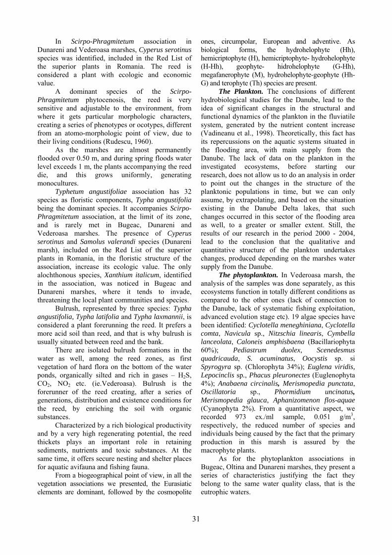
The Plankton. The conclusions of different hydrobiological studies for the Danube, lead to the idea of significant changes in the structural and functional dynamics of the plankton in the fluviatile system, generated by the nutrient content increase (Vadineanu et al., 1998). Theoretically, this fact has its repercussions on the aquatic systems situated in the flooding area, with main supply from the Danube. The lack of data on the plankton in the investigated ecosystems, before starting our research, does not allow us to do an analysis in order to point out the changes in the structure of the planktonic populations in time, but we can only assume, by extrapolating, and based on the situation existing in the Danube Delta lakes, that such changes occurred in this sector of the flooding area as well, to a greater or smaller extent. Still, the results of our research in the period 2000 - 2004, lead to the conclusion that the qualitative and quantitative structure of the plankton undertakes changes, produced depending on the marshes water supply from the Danube.
The phytoplankton. In Vederoasa marsh, the analysis of the samples was done separately, as this ecosystems function in totally different conditions as compared to the other ones (lack of connection to the Danube, lack of systematic fishing exploitation, advanced evolution stage etc). 19 algae species have been identified: Cyclotella meneghiniana, Cyclotella comta, Navicula sp., Nitzschia linearis, Cymbella lanceolata, Caloneis amphisbaena (Bacillariophyta 60%); Pediastrum duolex, Scenedesmus quadricauda, S. acuminatus, Oocystis sp. si Spyrogyra sp. (Chlorophyta 34%); Euglena viridis, Lepocinclis sp., Phacus pleuronectes (Euglenophyta 4%); Anabaena circinalis, Merismopedia punctata, Oscillatoria sp., Phormidium uncinatus, Merismopedia glauca, Aphanizomenon flos-aquae (Cyanophyta 2%). From a quantitative aspect, we recorded 973 ex./ml sample, 0.051 g/m3, respectively, the reduced number of species and individuals being caused by the fact that the primary production in this marsh is assured by the macrophyte plants.
As for the phytoplankton associations in Bugeac, Oltina and Dunareni marshes, they present a series of characteristics justifying the fact they belong to the same water quality class, that is the eutrophic waters.
31

• The blue algae (Cyanophytes) present the highest numeric abundancy. The dominant and eudominant species belong to this group;
• The numeric abundancy of the Cyanophytes exceeds the algae blossom threshold in all the collecting stations.
We notice that the distribution of the phytoplankton population is relatively uniform in the collecting stations in Oltina and Dunareni marshes in 2004. The greatest number of individuals is recorded in the junction sector between the marshes and the supply channels from the Danube (including Bugeac marsh). In Dunareni, a maximum is recorded in the southern station as well, at the junction with the supply channel from Beilic marsh.
The ecologic state of Bugeac marsh is better than that of Oltina and Dunareni marshes, even if they are included in the category of eutrophic marshes. In the case of this marsh, we can notice that the numeric density of cyanophytes, in each collecting stations, is smaller than that in Oltina and Dunareni marshes (Fig. 5, 6, 7).
Figure 5, Comparative analysis of the distribution of algae groups to the collecting stations in Oltina marsh (August
2004)
Figure 6, Comparative analysis of the distribution
of algae groups to the collecting stations in Bugeac marsh (August 2004)
Bugeac marsh presents different
characteristics than the other two analysed marshes, in terms of phytoplankton diversity. Thus, by analysing the phytoplankton biodiversity, we could notice that Bugeac marsh has the highest value of the diversity index.
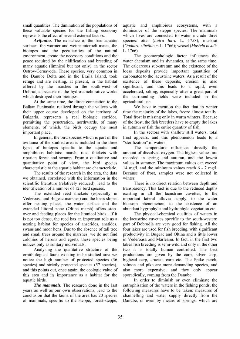
Figure 7, Comparative analysis of the distribution of algae
groups to the collecting stations in Dunareni marsh (August 2003)
The structure of the phytoplankton
associations in Oltina and Dunareni marshes presents a relatively high degree of similarity.
On the other hand, we have to mention the fact that the ecologic state of Dunareni marsh registers a strong degradation tendency. Therefore:
• the comparative analysis of the numeric density recorded in 2003, and in 2004 respectively, reveals the doubling of the number of algae on a litre of analysed sample;
• the significant decrease of the diversity index from 2.03 in 2003 to 1.7 in 2004.
On the basis of the data on the structure of the phytoplankton associations in Bugeac, Oltina and Dunareni marshes, we can make the following observations:
- the three marshes are included in the category of eutrophic marshes with significant algae blossom in summer;
- the marshes have a high similarity degree; - Dunareni marsh registers a great quality
water degrading tendency. The zooplankton. In the zooplanktonic
associations identified in Bugeac, Dunareni, Oltina marshes, 54 species belonging to Rotatoria, Cladocera and Copepoda groups were determined (Fig. 8, 9, 10).
From a point of view of the specific components, the rotifers are represented by 30 species. Among these, the most abundant were the microfiltrating species of Brachionus: Brachionus diversicornis, Brachionus calyciflorus f. amphiceros, Brachionus calyciflorus var. pala, Brachionus angularis, Brachionus quadridentatus var. cluniorbicularis genus, as well as Asplanchna herrichi species, from the optional macrofiltrating predators. The greatest development was recorded by Brachionus diversicornis species, which is present in all the three studied ecosystems, in Oltina marsh it occupies the first place in terms of ecologic specification index.
32
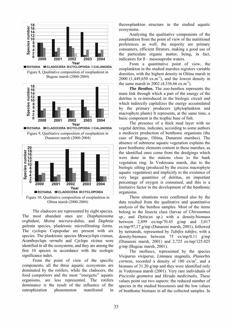
Figure 8, Qualitative composition of zooplankton in
Bugeac marsh (2000-2004)
Figure 9, Qualitative composition of zooplankton in
Dunareni marsh (2000-2004)
Figure 10, Qualitative composition of zooplankton in
The cladocers are re resented by eight species. The
oint of view of the specific comp
ing the qualitative components of the zoopl
view, the zoopl
sents the main
with no veget
situations were confirmed also by the data
nted by the species Vivipa
Oltina marsh (2000-2004) p
most abundant ones are: Diaphanosoma orghidani, Moina micrura-dubia, and Daphnia galeata species, planktonic microfiltrating forms. The cyclopic Copepodae are present with six species. The planktonic species Mesocyclops crassus, Acanthoyclops vernalis and Cyclops vicinus were identified in all the ecosystems, and they are among the first 10 species in accordance with the ecologic significance index.
From the ponents, all the three aquatic ecosystems are
dominated by the rotifers, while the cladocers, the food competitors and the most “energetic” aquatic organisms, are less represented. The rotifers dominance is the result of the influence of the eutrophization phenomenon manifested in
thezooplankton structure in the studied aquatic ecosystems.
Analysankton from the point of view of the nutritional
preferences as well, the majority are primary consumers, efficient fitrators, making a good use of the particulate organic matter, being, in fact, indicators for ß – mesosaprobe waters.
From a quantitative point ofankton in the studied marshes registers variable
densities, with the highest density in Oltina marsh in 2000 (1,449,650 ex.m-3), and the lowest density in the same marsh in 2002 (4,336.66 ex.m-3).
The Benthos. The zoo-benthos reprelink through which a part of the energy of the
detritus is re-introduced in the biologic circuit and which indirectly capitalizes the energy accumulated by the primary producers (phytoplankton and macrophyte plants) It represents, at the same time, a basic component in the trophic base of fish.
The presence of a thick mud layer al detritus, indicates, according to some authors
a mediocre production of benthonic organisms (the case of Bugeac, Oltina, Dunareni marshes). The absence of submerse aquatic vegetation explains the poor benthonic elements content in these marshes, as the identified ones come from the dredgings which were done in the stations close to the bank vegetation ring. In Vederoasa marsh, due to the biologic silting (produced by the excess macrophyte aquatic vegetation) and implicitly to the existence of very large quantities of detritus, an important percentage of oxygen is consumed, and this is a limitative factor in the development of the benthonic organisms.
Theseresulted from the qualitative and quantitative
analysis of the benthos samples. Most of the items belong to the Insecta class (larvae of Chironomus sp., and Dytiscus sp.) with a density/biomass between 2,899 ex/mp/70.45 g/mp and 3,017 ex/mp/97,17 g/mp (Dunareni marsh, 2001), followed by nematods, represented by Tubifex tubifex, with a density/biomass between 75 ex/mp/0.11 g/mp (Dunareni marsh, 2001) and 2,725 ex/mp/125.025 g/mp (Bugeac marsh, 2001).
The molluscs, represerus viviparus, Limnaea stagnalis, Planorbis
corneus, recorded a density of 180 ex/m2, and a biomass of 31.20 g/mp and they were identified only in Vederoasa marsh (2001). Very rare individuals of Piscicola geometra and Hirudo medicinalis. These values point out two aspects: the reduced number of species in the studied biocenosis and the low values of benthonic biomass in all the collected samples. In
33

the samples taken in September 2001 in Oltina marsh, benthonic forms were not identified. The simplifying of the qualitative and quantitative structure of the benthonic fauna has repercussions on the benthanophag fish, especially on the carp, and this fact is reflected in the fishing production, in which the planktonophag Asian Cyprinides are dominant in comparison to the carp.
The amphibians and reptiles. As a result of the fi
hthyofauna. As a result of the taxonomic invest
cture of ichthyofauna in Veder
uced species diversity reflects the answe
Bugeac, Oltina, Dunareni and Baciu
ied with nu
eld observations, correlated with the existent data in the scientific literature and the information provided by other researchers studying this area, we establish the structure if this group of creatures, including nine species of amphibians and nine species of reptiles. Five of these are common species, five are almost threatened, six are vulnerable and two are endangered: Triturus vulgaris Linnaeus, 1758 (common triton); Triturus dobrogicus Kiritzescu, 1903 (Dobrudjan crest triton); Bombina bombina Linnaeus, 1758 (red belly marsh bittern); Pelobates fuscus Laurenti, 1768 (brown digging frog); Hyla arborea Linnaeus, 1758 (green frog); Bufo viridis Laurenti, 1768 (green toad); Rana dalmatina Bonaparte, 1839 (red forest frog); Rana ridibunda Pallas, 1841 (great lake frog); Rana esculenta Linnaeus, 1758 (small lake frog); Emys orbicularis Linnaeus, 1758 (marsh turtle); Testudo graeca ibera Linnaeus, 1758 (Dobrudjan land turtle); Lacerta viridis Laurenti 1768 (green lizard); Lacerta agilis chersonensis Andrzejowski (field lizard); Podarcis taurica Pallas, 1841 (grass lizard); Natrix natrix Linnaeus, 1758 (home snake); Natrix tessellata Laurenti, 1768 (water snake); Coluber caspius Gmelin, 1789 (steppe snake); Coronella austriaca Laurenti, 1768 (hazel nut snake).
Icigations we made on the fish material collected
from the commercial captures and sportsmen captures, we noticed that the qualitative structure of ichthyofauna is made up of 18 species of fresh water fish, peaceful and predatory and a breeding variety (take 15). Of these, 12 species are found in the commercial captures from Bugeac, Oltina, Dunareni and Baciu marshes: breeding carp (Cyprinus carpio var. galitiana), crucian carp (Carassius gibelio Bloch, 1782), bream (Abramis brama L., 1758), roach (Rutilus rutilus L., 1758), white bream (Blicca bjoerkna L., 1758), Asian Cyprinides (Hypophthalmichthys molitrix Valenciennes, 1844; Aristichthys nobilis Richardson, 1845; Ctenopharyngodon idella Valenciennes, 1844), asp (Aspius aspius L., 1758), pike (Esox lucius L., 1758), Spike perch (Sander lucioperca L., 1758) and salmon (Silurus glanis L., 1758). Other species
included in the present ichthyofauna but which very rarely appear in the fishing captures are: perch (Perca fluviatilis Linnaeus, 1758), rudd (Scardinius erythrophthalmus L., 1758), sun-perch (Lepomis gibbosus L., 1758), black-tail (Gymnocephalus cernuus L., 1758), marsh gudgeon (Neogobius fluviatilis Pallas, 1814).
As for the stru
Da
oasa marsh, it is determined by the nature and abundance of the emerse and submerse vegetation present in the ecosystem, as well as by the lack of connection with the Danube. Thus, the emerse vegetation, (reed, bulrush, sedge or shave grass), invading the marsh on a large area, offers favourable living conditions for the carp, roach, rudd, crucian carp, crucian (Carassius carassius L. 1758), pike and perch, but at the same time it is a limitative factor due to the reduction of the water surface. The submerse vegetation, especially in the fields of Myriophyllum sp. And Chara sp., offers food and shelter for fish babies of the above mentioned species. The interruption of water supply from the river, caused a diminution of ichthyofauna in terms of number of species, as well as the variety of the genetic base.
The redr of the fish population to the environmental
changes (interruption of the free communication with the Danube, unsatisfied food requirements, disappearance of specific habitats, acclimatization of Chinese species), but also to the fishing administration. Of the wild species we can mention the presence of three protected species on a national and international level: asp (considered as an endangered species in Europe, but frequent and abundant in Romania), crucian (threatened in all its distribution area, but not protected at an European level) and salmon.
Every year, marshes are populated with saplings of carp,
Asian Cyprinides and crucian carp sometimes. In Oltina marsh, the grasshopper is not introduced due to the absence of hard vegetation, which is the basic food for this species. We do not have data on the adaptation of the Asian Cyprinides in these marshes, except some information given by Iana (1970) about the populating of the Bugeac marsh, in 1967, with young silver carp and grasshopper, the fishing material being brought from Calica marsh (Danube Delta) and Nucet Fishing Research Station.
In spring, when the marshes are supplbe water, the pike, pike perch, bream, salmon,
crucian carp, white bream etc penetrate accidentally and they reproduce eventually in this aquatic basins, contributing to the total fish production, but in very
34
small quantities. The diminution of the populations of these valuable species for the fishing economy represents the effect of several external factors.
Avifauna. The existence of the free aquatic surfac
ct connection to the Balka
he bird species which is part of the avifau
we ob
y in Veder
ructure of the ornith
ls. The research done in the last years
geomorphologic factor influences the water
mention the fact that in winter time t
rs, total frost
influences directly the amou
ere is no direct relation between depth and transp
the la
liminate the eutrop
es, the warmer and wetter microcli mates, the biotopes and the peculiarities of the natural environment, create the necessary conditions and the peace required by the nidification and breeding of many aquatic (limnicol but not only), in the sector Ostrov-Cernavoda. These species, very common in the Danube Delta and in the Braila Island, took refuge and are nesting, at present, in the habitat offered by the marshes in the south-west of Dobrudja, because of the hydro-ameliorative works which destroyed their biotopes.
At the same time, the diren Peninsula, realized through the valleys with
their upper course developed on the territory of Bulgaria, represents a real biologic corridor, permitting the penetration, northwards, of many elements, of which, the birds occupy the most important place.
In general, tna of the studied area is included in the three
types of biotopes specific to the aquatic and amphibious habitats: marsh, reed thickets with riparian forest and swamp. From a qualitative and quantitative point of view, the bird species characteristic to the aquatic habitat are characteristic.
The results of the research in the area, the data tained, correlated with the information in the
scientific literature (relatively reduced), lead to the identification of a number of 123 bird species.
The extended reed thickets (especialloasa and Bugeac marshes) and the loess slopes
offer nesting places, the water surface and the extended littoral zone (Oltina marsh) offers stop-over and feeding places for the limnicol birds. If it is not too dense, the reed has an important role as a nesting habitat for species of anserides, anatides, swans and moor hens. Due to the absence of tall tree and small trees around the marshes, we do not find colonies of herons and egrets, these species being notices only as solitary individuals.
Analysing the qualitative stological fauna existing in he studied area we
notice the high number of protected species (36 species) and strictly protected species (57 species), and this points out, once again, the ecologic value of this area and its importance as a habitat for the aquatic birds.
The mammaas well as our own observations, lead to the
conclusion that the fauna of the area has 20 species of mammals, specific to the steppe, forest-steppe,
aquatic and amphibious ecosystems, with a dominance of the steppe species. The mammals which lives are connected to water include three species: otter (Lutra lutra L. 1758); muskrat (Ondatra zibethicus L. 1766); weasel (Mustela nivalis L. 1766).
The chemism and its dynamics, at the same time.
The calcareous sub-stratum and the existence of the loess deposits provide important quantities of carbonates to the lacustrine waters. As a result of the existence of these deposits, erosion is also significant, and this leads to a rapid, even accelerated, silting, especially after a great part of the surrounding fields were included in the agricultural use.
We have tohe majority of the lakes, freeze almost totally.
Total frost is missing only in warm winters. Because of the frost, the fish breeders have to empty the lakes in autumn or fish the entire quantity of fish.
In the sectors with shallow still wateappears, and this phenomenon leads to a
“sterilization” of waters. The temperature nt of dissolved oxygen. The highest values are
recorded in spring and autumn, and the lowest values in summer. The maximum values can exceed 14 mg/l, and the minimum values reach 6 - 7 mg/l. Because of frost, samples were not collected in winter.
Tharency. This fact is due to the reduced depths
existing in all the lacustrine cuvettes, to the important lateral alluvia supply, to the water blossom phenomenon, to the existence of an abundant hygrophyle and hydrophyle vegetation etc.
The physical-chemical qualities of waters in custrine cuvettes specific to the south-western
part of Dobrudja are very good for fishing. All the four lakes are used for fish breeding, with significant productivity in Bugeac and Oltina and a little lower in Vederoasa and Mârleanu. In fact, in the first two lakes fish breeding is semi-wild and only in the other two it is totally human controlled. The best productions are given by the carp, silver carp, bighead carp, crucian carp etc. The Spike perch, salmon and pike are more demanding species, and also more expensive, and they only appear sporadically, coming from the Danube.
In order to diminish or even ehisation of the waters in the fishing ponds, the
following measures have to be taken: measures of channelling and water supply directly from the Danube, or even by means of springs, which are
35
very frequent in the area, favoured by the existence of the calcareous and even loess deposits.
Besides the agricultural usage (fishing activi
.CONCLUSIONS
he valleys on which the fluvio-maritime liman
e rapid evolution of the limans valleys is accele
ties and irrigations) the fluviatile limans in the south-west of Dobrudja have a totally unexploited tourist potential. The only “tourist” unit is Dervent monastery, which attracts thousands of tourist, but mainly with religious purposes and less recreational.
5 Ts were formed, inherited former river mouths
of golf type within the former Romanian lake in the Romanian Plain. These were closed by the fluviatile waters during floods, and transformed into fluviatile limans.
Thrated by the string pipping and soil
degradation processes, specific to the Dobrudja area. We have to mention the fact that pipping is facilitated by the existence of an important variation of level at the margin of the Dobrudja land, which transforms it into a specific type of phenomenon: margin pipping (due the high slopes from the west and north of the tableland).
Figure 11. Industrial fishing is the most important source
he accelerated erosion (produced by man)
cause
ical point of view, the w
rine cuvet
ACKNOWLEDGEMENTS
We owe our thanks to the owners who inist
EFERENCES
Aerni, P., 2004. tion and innovation: The
Airine 1980. Radiografia geofizica a subsolului
Basar Rolul apelor torentiale asupra
Botna a.
Brate iliar
Cabez do, B., Garcia, M.,
Conea ea.
Cotet tie.
Cotet 978. Depozitele cuaternare din Dobrogea (cu
Dami gescu, A., 1963. Fauna R.P.R., Crustacea:
205.
of food and income in the south-western sector of
Dobrudja
Ts an intensification of the solid transport and a
silting of the lacustrine cuvette. On the secondary valleys, as a result of the massive alluvia deposits, the river bed is aggradated and it gets away from the phreatic, becoming a dry valley.
From a physical and chemater of the four lacustrine cuvettes has a good
quality, and they create good conditions for fishing (Fig. 11). Nevertheless, especially in the last 30 years, an intense eutrophization is noticed, and this
leads to a repeated decrease of the productivity. At the same time, for several lacust
tes, a significant extent of vegetation is noticed, especially the reed and bulrush. From this point of view, the most affected lakes are Dunareni, Vederoasa and Baciu. Practically, they transformed or they are about to become, typical wetlands, among the greatest in Southern Dobrudja.
adm rate the four lakes, for their kindness in facilitating our research and in providing the material support. Our thanks also go to the Eco-Museal Research Institute Tulcea and to the Laboratory of Geo-archaeology within the Department of Geography, Faculty of Geography and Geology in Iasi, were a part of the collected samples were processed and interpreted. A very important support was given by the Romanian Railway National Society, Bucharest, where the limnisoil samples were analysed.
R
Risk, regulacase of aquaculture and transgenic fish. Aquatic Science – Research Across Boundaries, 66, 3, 327 - 341. i, S., României. Editura Stiintifica si Enciclopedica, Bucuresti, 258 pp. abeanu, N., 1969. modelarii reliefului actual din Dobrogea. Studii geografice asupra Dobrogii, Bucuresti, 1, 65-69. riuc, N., 1967. Principii de biologie generalEditura Academiei Romane, Bucuresti, 241 pp.
scu, C., 1928. Pamântul Dobrogii. Volum jub„Dobrogea”, Bucuresti, 3-66. as, A., Gonzales, E., GallarGonzales, M. & Comin, F.A., 2008. Effects of hydrological connectivity on the substrate and understory structure of riparian wetlands in the middle Ebro river (NE Spain): implication for restoration and management. Aquatic Science – Research Across Boundaries, 20, 4, 347 - 360. , A., 1970. Formatiuni cuaternare in DobrogEditura Academiei Române, Bucuresti, 234 pp.
, P., 1969. Dobrogea de Sud – geneza si evoluStudii geografice asupra Dobrogii, Bucuresti, 1, 7 - 19.
, P., 1privire speciala asupra argilelor rosii). Studii si comunicari de geografie-geologie si mediu ambiant, Peuce, Muzeul Delta Dunarii, Tulcea, 5, 59-68.
an-GeorCopepoda, Fam. Cyclopidae (forme de apa dulce). Editura Academiei Române, Bucuresti, 4, 6, 1 -
36
Damiaoda, Fam. Calanoida (forme de apa dulce).
Dinu,elor fluviatile din sud-vestul Dobrogei. Studia
Dinu, communities from
Dinu,ice din limanele fluviatile Bugeac si
Dinu,Hydrobiological Characteristics of Dunareni
Doddhic state in aquatic ecosystem: It’s not just the
DussaIdentification of the
FeketCarpth. J. Of
Füzesns
Gâste
. Editura
Hakaniscus,
Hardind calanoid copepods. Far
Iana, rogei de Sud. Stud. Com. Ocrot. Nat., Suceava,
Iancu asupra Dobrogii dunarene de sud.
Ianos, I., Peptenatu, D., Zamfir, D., 2009. Respect for
ournal of Earth and Environmental
Jelea,
s from Romplumb Society
Kieffe
Kram ., 1986.
uer, D.
Kram
aceae, Surirellaceae. In Ettl, H., Gerloff,
Kram
H.
Kram
., Gerloff, J., Heynig, H.
Lacat
Murg ., 1957. Opere alese. Editura Academiei
Negre : Cladocera.
biologia, Editura Academiei Romane,
Popov
ica, Bucuresti, 301 pp.
lui
Roma
au, 406 pp.
n–Georgescu, A., 1966. Fauna R.P.R., Crustacea: CopepEditura Academiei Române, Bucuresti, 4, 8, 1 - 128.
C., 2004. Date privind structura ihtiofaunei limanUniversitatis „Vasile Goldis”, Seria Stiintele Naturii, Arad, 14, 105 - 108.
C., Petrescu, M. & Radu, A., 2002. Contribution to the aquatic and marsh plantVederoasa Lake. Analele I.N.C.D.P.D.D., Tulcea, 1: 69 - 74.
C. & Radu, A., 2004. Date privind conditiile hidrobiologOltina (Constanta). Delta Dunarii, Tulcea, 2, 25 - 38.
C., Radu, A. & Török, L., 2005. Data Concerning the Lake (Constanta County). Studii si cercetari stiintifice, Biologie, Universitatea Bacau, 10, 33 - 36.
s, W. & Cole, J.J., 2007. Expanding the concept of tropautotrophs. Aquatic Science – Research Across Boundaries, 69, 4, 427 - 439. rt, B. & Defaye, D., 1995. Copepoda. Introduction to the Copepoda. Guides to Microinvertebrates of the Continental Waters of the World. Coordonating editor: H.J.F. Dumont, SPB Academic Publishing, 277 pp.
e, J.G., 2006. Education,research and development tasks of environmental protection, Earth and Environmental Sciences, 1, 2, 5 – 12.
i, I., 2007. Loess tests carried out in the surroundings of some covered karstic depressio(Tes-Plateau). Carpathian Journal of Earth and Environmental Sciences, 2, 2, 39 – 44.
scu, P., 1971. Lacurile din România. Editura Academiei Române, Bucuresti, 372 pp.
Gomoiu, M.T. & Skolka, M., 2001. Ecologie – Metodologii pentru studii ecologiceOvidius University Press, Constanta, 175 pp. sson, H., 2002. A Compilation and Evaluation of Species in the General StephanodCyclostephanos and Cyclotella with a New Genus in the Familie Stephanodiscaceae. Diatom Research, Stuttgart, 17, 1, 1 - 139. ng, J.P. & Smith, W.A. 1974. A key to the British freshwater cyclopid aSawrey, Cumbria: Freshwater Biological Association, FBA Special Publication, 18, 2, 1 - 54. S., 1970. Noutati faunistice in ecosistemele
Dob251-256. , M. & Iana, S., 1969. Consideratii fizico-geograficeStudii geografice asupra Dobrogii, Bucuresti, 1, 106 - 132.
environment and sustainable development. Carpathian JSciences, 4, 1, 81-93.
S.G., Jelea M., 2007. Effects of polluting substances on risk categori molten and agglomeration workerBaia Mare. Carpathian Journal of Earth and Environmental Sciences, 2, 1, 51 – 57. r, F., 1960. Ruderfuss-Krebse (Copepoden). Kosmos-Verlag, Franckh-Stuttgart, 97 pp. mer, K. & Lange-Bertalot, HBacillariophyceae. 1. Teil: Naviculaceae. In Ettl, H., Gerloff, J., Heynig, H. And Mollenha(eds), Süsswasser flora von Mitteleuropa, Band 2/1. Gustav Fischer Verlag: Stuttgart, New York, 876 pp. mer, K. & Lange-Bertalot, H., 1988. Bacillariophyceae. 2. Teil: Bacillariaceae, EpithemiJ., Heynig, H. And Mollenhauer, D. (eds), Süsswasser flora von Mitteleuropa, Band 2/2. Gustav Fischer Verlag: Stuttgart, Jena, 596 pp. mer, K. & Lange-Bertalot, H., 1991A. Bacillariophyceae-Achnanthaceae, Navicula, Gomphonema. In Ettl, H., Gerloff, J., Heynig, And Mollenhauer, D. (eds), Süsswasser flora von Mitteleuropa, Band 2/3. Gustav Fischer Verlag: Stuttgart, Jena, 576 pp. mer, K. & Lange-Bertalot, H., 1991B. Bacillariophyceae-Centrales, Fragilariaceae, Eunotiaceae. In Ettl, HAnd Mollenhauer, D. (eds), Süsswasser flora von Mitteleuropa, Band 2/4. Gustav Fischer Verlag: Stuttgart, Jena, 437 pp. usu, R., 2000. Mineralogia si geochimia argilelor aptiene din Dobrogea de Sud. Editura Corson, Iasi, 171 pp.
Mihailescu, V., 1966. Dealurile si câmpiile României. Editura Stiintifica, Bucuresti, 203 pp.
oci, G.MRomâne, Bucuresti, 404 pp. a, S., 1983. Fauna R.S.R., CrustaceaEditura Academiei Române, Bucuresti, 4, 12, 1 - 399.
Popescu-Gorj, A. & Costea, E., 1961. Cercetari hidrobiologice si piscicole in baltile Oltinei. HidroBucuresti, 2, 23 - 125. ici, I., Grigore, M., Marin, I. & Velcea, I., 1984. Podisul Dobrogei si Delta Dunarii. Editura Stiintifica si Encicloped
Romanescu, G., 1995. Consideratii geomorfologice preliminare asupra sectorului central-nordic al Dealurilor Tulcene. Lucrarile SeminaruGeografic “Dimitrie Cantemir”, 1991-1992, Iasi, 11-12, 17 - 28. nescu, G. & Jigau, G., 1998. Geomorfologie. Editura Universitatii de Stat din Republica Moldova, Chisin
Romanescu, G., 2003. Hidrologie generala. Editura
37
38
Rozyc vents portant la
loess en Bulgarie et en
Rudes
ross Boundaries, 66, 4, 343
Szücs
nd Environmental Sciences, 1, 2, 45 – 50.
, 57 - 61.
latiilor fitoplanctonice. Delta
Tufes
s along the lower Danube River
Van D
s.
Received at: 04. 01. 2010
at: 30. 03. 2010
Terra Nostra, Iasi, 560 pp. ki, S.Z., 1967. Le sens despoussière de loess, a la lumière de l’analyse des formes d’accumulation du Europe Centrale. Revue de Géomorphologie dynamique, Paris, 17, 1, 1 - 9. cu, L., 1960. Fauna R.P.R., Trochelminthes – Rotatoria. Editura Academiei Române, Bucuresti, 2, 2, 1 - 1192.
Sallenare, R. & Cowley, D.E., 2004. Aquatic resources in arid lands: issues and opportunities. Aquatic Science – Research Ac- 345.
né-Murguly, M., 2006. The anthropogenic impacts on the Ecsedi-Lap wetlands. Carpathian Journal of Earth a
Tockner, K., Ward, J.V., Edwards, P.J. & Kollmann, J., 2002. Riverine landscapes: an introduction. Freshwater Biology, 47, 497 - 500.
Török, L., 2004. Methods used for Diatoms’ Studies in the Danube Delta-Part I. Analele Stiintifice ale Institutului Delta Dunarii, Tulcea, 10
Török, L., 2006. Data on the Diversity of Diatom Species from the Danube Delta-Part II. Delta Dunarii, Tulcea, 3, 85 - 108.
Török, L. & Dinu, C., 2006. Evaluarea starii de calitate a apei din lacurile Oltina, Bugeac si Dunareni pe baza structurii popuDunarii, Tulcea, 3, 109 -128.
cu, V., 1966. Modelarea naturala a reliefului si eroziunea accelerata. Editura Academiei Române, Bucuresti, 612 pp.
Vadineanu, A., Cristofor, S., Sârbu, A., Romanca, G., Ignat, G., Botnariuc, N. & Ciubuc, C., 1998. Biodiversity changeSystem. International Journal of Ecology and Environmental Sciences, New Delhi, 24, 315 - 332. am, H., Mertens, A. & Sinkeldam, J., 1994. A Coded Checklist and Ecological Indicator Values of Freshwater Diatoms from the NetherlandNetherlands Journal of Aquatic Ecology, 28, 1, 117 - 133.
Revised at 07. 01. 2010 Accepted for publicationPublished online at: 24. 04. 2010