transportation improvements & studies
TRANSCRIPT

1
Puget Neighborhood Association MeetingOnline – December 8, 2020
Transportation Improvements & StudiesIn and Around the Puget Neighborhood

Presentation Overview
• Big Picture: Bellingham’s Citywide Transportation Planning Practice [~ 2 mins]
• Recent: Transportation Projects - Samish & Puget Neighborhoods [~ 3 mins]• 2016-2017 Lakeway Drive Bikeway Study → 2018 Lakeway-Lincoln Multimodal Improvements• 2016-2017 Samish-Maple-Ellis Corridor Study → 2020 Samish-Maple-Ellis Multimodal Improvements• 2020 Transportation Benefit District Projects and 40th Street Sidewalk and Bike Lanes
• Today: Future Transportation Improvements in Puget Neighborhood• 2020-2021 Lincoln-Lakeway Multimodal Transportation Study [~ 15 mins]
• Interstate 5 through Bellingham • I-5 Operations & TDM Study (WSDOT staff) [~20 mins]
• Questions/Discussion

3
Bellingham is the Regional Center (Employment, Shopping, Education, Medical Services, etc.)
Disproportionate
Number of
Vehicle Trips
In/Out of City
each day
Out of town
visitors generate
a lot of sales tax

4
• Since 1980, the City population has doubled from 46,000 to 92,000
• 25% of City limits added north of 1904 boundaries via annexation since 1980
• 1990’s = predominantly commercial & industrial land to generate sales tax revenue, which provides almost all local transportation funding (General Fund, Street Fund, WTA Levy, Bham TBD)
• 2000’s = predominantly residential land, which does not generate much tax revenue and is very expensive to provide urban services to
• When UGA annexes, City inherits old, narrow, rural standard roads with no shoulders, no sidewalks, no bike lanes
• Extremely expensive to retrofit rural roads to urban multimodal complete streets
City Growth & Annexation of Urban Growth Area (UGA)

Bellingham Plansto Continue GrowingPast & Future Population Growth
• 1980 = 46,000
• 2000 = 67,000
• 2020 = 92,000
• 2040 = 125,000 (Projected)

6
Bellingham: Who Are We Planning For? PEOPLE
BALANCE:All mobility needs
for all modes must be carefully considered, balanced, and implemented
so that the multimodal transportation system can provide space and safety
for everyone.
So…. What should we measure? Safe mobility for PEOPLE
Source: Multimodal Transportation Chapter – 2016 Bellingham Comprehensive Plan

7
Bellingham’s Active Transportation Plans
Pedestrian Master Plan (2012)
• 258-mile pedestrian network
• ~ 162 miles (63%) complete
• 343 Prioritized sidewalks + crossings
Bicycle Master Plan (2014)
• 164-mile bicycle network
• ~ 87 miles (53%) complete
• 215 Prioritized bikeways + crossings
Multiuse Greenways Trails (1990 x4)
• Extensive citywide trail system
• 80 miles existing multiuse trails
• 61 miles (76%) = secondary transportation
Slide 7


Assembling this complex puzzle, piece by expensive piece
Short-term (2017 thru 2019)1.) 2017 - Uphill climbing lane on Woburn (Iowa to Lakeway); Green bike box at Woburn/Lakeway2.) 2018 - HAWK signals at three locations on Lakeway Drive [Undine; Orleans; Grant]3.) 2018 - Marked bike lanes from Undine HAWK to Puget - Green bike box north leg at Puget;4.) 2019 - Lakeway shared bike-ped path from Undine HAWK to Old Lakeway Bike Blvd
Mid-term (2020 thru 2025)5.) 2020 - Old Lakeway Bike Blvd (Yew-Lakeway) connect to Woburn/Lakeway 6.) Work with BSD and Parks to re-organize Orleans-Lincoln block on Lakeway Drive- Consider Safe Route to School grant with reconstruction of Carl Cozier ES (2024-2025)
Long-term (2025 and beyond)7.) Further Study Needed on Lakeway Drive corridor from Lincoln to Ellis
2016-2017 Lakeway Drive Bikeway Study

2018 Lakeway-Lincoln Multimodal Improvements
• $1,250,000 WSDOT Pedestrian-Bicycle Safety grant funds, plus local matching funds
• Upgrade 3 flashing amber crossings to red HAWK signals• Lakeway/Grant • Lakeway/Orleans• Lincoln/Fred Meyer
• New HAWK signal at Lakeway on the west side of the Undine intersection
• Sidewalk on Orleans (west side) from Lakeway Drive to Potter Street
• Sidewalk on Nevada Street-44th Street (east side) from Whatcom Street to Thimbleberry
• Nevada-Byron-Ashley-Dumas-40th Bike Boulevard and traffic calming from Lakeway to Elwood
• Grant-Humboldt-Otis-34th Bike Boulevard from Meador Avenue to Bill McDonald Parkway
• $250,000 TIB grant for new flashing crosswalk at N. Samish/Otis

Samish-Maple-Ellis Multimodal Safety Improvements
$1,007,000 WSDOT Pedestrian & Bicycle Safety Grant + local matching funds
What do these improvements include?
1.5-mile-long N. Samish-Maple-Ellis-York corridor from I-5/Samish interchange to Lakeway Drive (Red →) and then to Cornwall Avenue (Green →) will experience major changes, including:
• Bill McDonald Pkwy to Chestnut St: 1 vehicle lane in each direction will be removed and replaced with buffer-separated bike lanes;
• Chestnut St to Lakeway Dr and Cornwall Ave: Vehicle lanes will be rechannelized for installation of marked and buffered bike lanes;
• Bill McDonald Pkwy/35th St: Flashing crosswalk installed across Bill McDonald Parkway between the Sehome Haggen and 35th Street, one of the busiest WTA bus stops serving WWU and Sehome High School;
• Ellis St/Glastone St: Flashing crosswalk installed across Ellis Street between York Neighborhood and Eleanor Senior Resident Apts; and,
• Green bike boxes installed at some signalized intersections where safety conflicts exist and bicycle connections are needed for people riding bikes.
See Frequently Asked Questions document for study documentation, extensive public process, and transportation grant funding

Corridor Segment 4

• 40th Street sidewalk east side from Fielding to Elwood
• Crosswalks at 40th/Elwood
• Rechannelize street to retain on-street parking, but eliminate center turn lane so that 5’ bike lanes can be installed per Bicycle Master Plan recommendation and per City arterial standard
• Wetland mitigation issues have delayed project, but it will be constructed winter 2020-2021
2020 Citywide TBD Projects and 40th Street Sidewalk and Bike Lanes

5
WWU
Civic
SamishNeighborhood
Sehome HS
WhatcomFalls Park
Waterfront
Public Works Plan for
Short-Term (2017-2020) and Long-Term (2021+)
Connectivity of Pedestrian & Bicycle Facilities between Puget Neighborhood and
Downtown Bellingham Puget
Neighborhood
2014 existing bicycle and intersection improvements
2018 bicycle and intersection improvements
Future unfunded links
2015 - 2017 bicycle and intersection improvements
2019 - 2020 bicycle and intersection improvements
Mobility Barriers WWU/WTAPark-N-Ride
Whatcom CrMultiuse Trail
South BayMultiuseTrail
Bikeways (except red)Trail connectionsIntersection ImprovementsGreen Bike Boxes
2020-2021Feasibility StudyES-0555
Lakeway
Downtown

2020-2021Lincoln-Lakeway Multimodal
Transportation Study
Assessing existing & future conditions for:
• People walking
• People biking
• People walking to bus stops
• People driving vehicles

• YMCA Proposal Presented to Bellingham City Council in June 2019 – Pre-COVID
• Relocate YMCA from downtown to Civic Field
• Major transportation impacts at Lincoln/ Lakeway, as well as surrounding streets.
Why Are We Doing This
Study Now?

But Wait! There’s More …..
• Carl Cozier Elementary School will need to be reconstructed in mid-2020’s and Bellingham School District is interested in a longer competitive swim pool
• This, combined with significant development already approved along Lincoln Street, N. Samish Way, and in surrounding neighborhoods led to Lincoln-Lakeway Study

Lincoln-Lakeway Multimodal Transportation Study Area
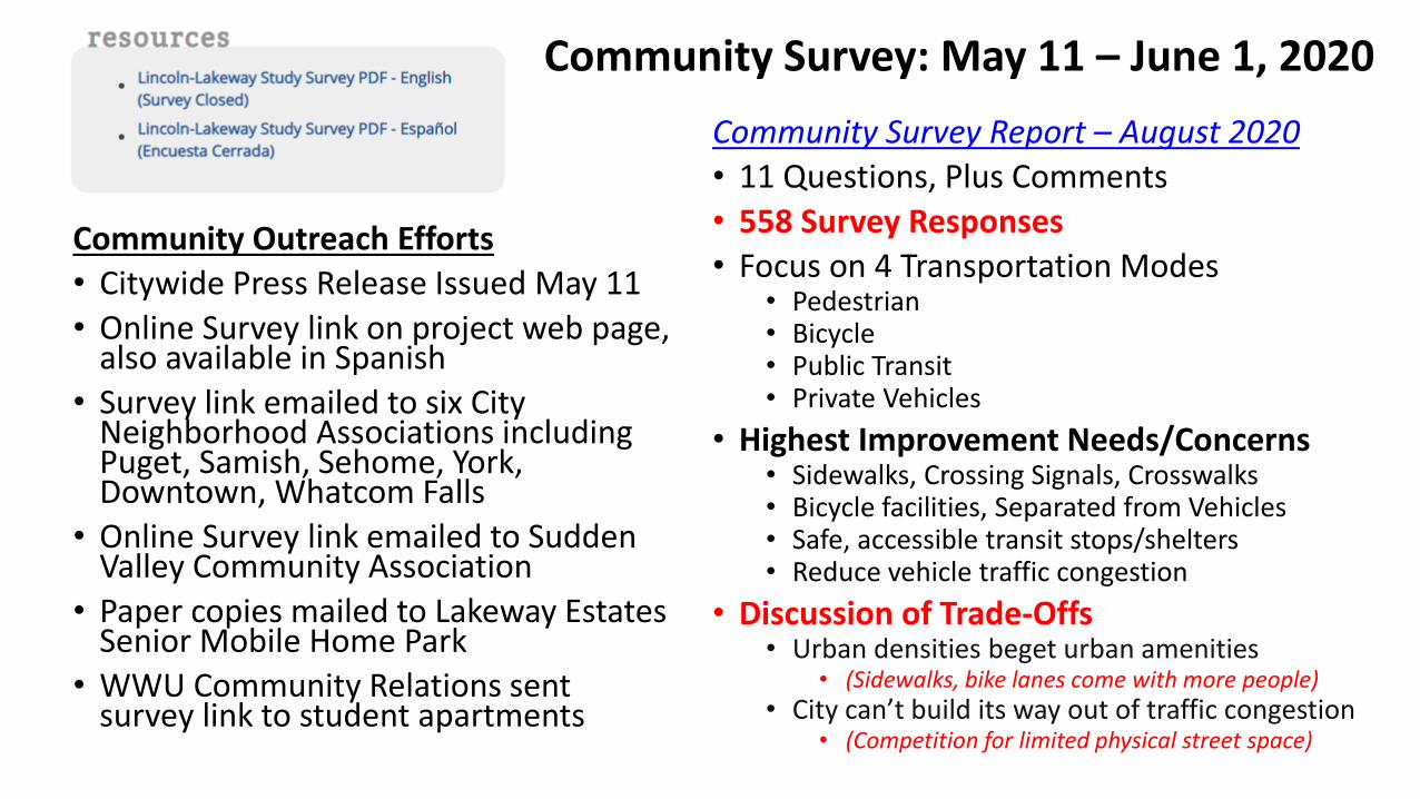
Community Survey: May 11 – June 1, 2020
Community Outreach Efforts
• Citywide Press Release Issued May 11
• Online Survey link on project web page, also available in Spanish
• Survey link emailed to six City Neighborhood Associations including Puget, Samish, Sehome, York, Downtown, Whatcom Falls
• Online Survey link emailed to Sudden Valley Community Association
• Paper copies mailed to Lakeway Estates Senior Mobile Home Park
• WWU Community Relations sent survey link to student apartments
Community Survey Report – August 2020
• 11 Questions, Plus Comments
• 558 Survey Responses
• Focus on 4 Transportation Modes• Pedestrian• Bicycle• Public Transit• Private Vehicles
• Highest Improvement Needs/Concerns• Sidewalks, Crossing Signals, Crosswalks• Bicycle facilities, Separated from Vehicles• Safe, accessible transit stops/shelters• Reduce vehicle traffic congestion
• Discussion of Trade-Offs• Urban densities beget urban amenities
• (Sidewalks, bike lanes come with more people)• City can’t build its way out of traffic congestion
• (Competition for limited physical street space)

Future Transportation Improvements Being Studied inLincoln-Lakeway Multimodal Transportation Study
New Traffic signals at:
• Lincoln/E. Maple
• N. Samish/Abbott
• N. Samish/Consolidation
• Lincoln/WWU Park-N-Ride (maybe)
New HAWK signal / Flashing crosswalk at:
• Lincoln/Viking Circle
New or Enhanced Bikeways on:
• Lakeway Drive: Puget beneath I-5 to Ellis
• Lincoln Street: Elwood to Lakeway
• N. State Street: York to Ohio
Future Feasibility Analysis for:
• Possible safety Improvements at:• Lincoln/Lakeway intersection• Lakeway/King intersection• Lincoln/Potter intersection• Lakeway/Orleans intersection
• Possible driveway realignments at:• Fred Meyer Gas & Grocery• Whole Foods Grocery
• Possible traffic circulation changes at:• Lakeway/King intersection• I-5 northbound on/off-ramps
• Others Yet To Be Determined

Improvement
Less
More
BMP Network
New Bike Facility Yew St to Bay St
• Lakeway Drive Bikeway from Puget to Ellis
• Ranked #2 of 185 individual projects in Bellingham Bicycle Master Plan
• 2016-2017 Bike Feasibility Study from Yew to Ellis
• Several bike links and crossings constructed from 2017-2019
• Western portion Puget to Ellis needs further study and support for bikeway under I-5

• Lakeway Drive Beneath I-5
• Recommended by City Bikeway Study
• Posted 25 mph
• Requires WSDOT to accept urban arterial lane widths rather than State Highway lane widths
• Lakeway is a city street, not just a freeway interchange
• Practical Solution• Multimodal Street• Complete Network• Safety for Vulnerable
Users on Bikes• Helps Mode Shift
and VMT Reduction

Lincoln-Lakeway Multimodal Transportation Study - What’s Next?
• Intersection Traffic Counts• October 13-16, 2020
• Existing Conditions Report• October-November 2020
• Neighborhood Meetings • October-November 2020
• “Engage Bellingham” platform →• November-December 2020
• Future Transportation Modeling• December 2020-February 2021
• Stakeholder Interviews • Yet to be determined, 2021
• Future Improvement Recommendations• April-May 2021
• Transportation Grant Applications• Beginning June 2021 and beyond

Transportation Plans & ImplementationResources on City of Bellingham web site
2020 Transportation Report on Annual Mobility (TRAM) = Annual Progress Report on Implementation
Multimodal Transportation Chapter – 2016 Bellingham Comprehensive Plan = GMA 20-Year Plan
2021-2026 Transportation Improvement Program (TIP) = Annual 6-Year Plan for Capital Improvements
2012 Pedestrian Master Plan = Citywide sidewalks and crossing improvements
2014 Bicycle Master Plan = Citywide bikeways and crossing improvements
Transportation Fund Story Map = Online, interactive, graphic illustration of all above

25
Chris Comeau, AICP-CTP, Transportation PlannerBellingham Public Works Engineering
360.778.7946 [email protected]
Questions or more information please contact: