transport for nsw - home - centre for maritime...
TRANSCRIPT
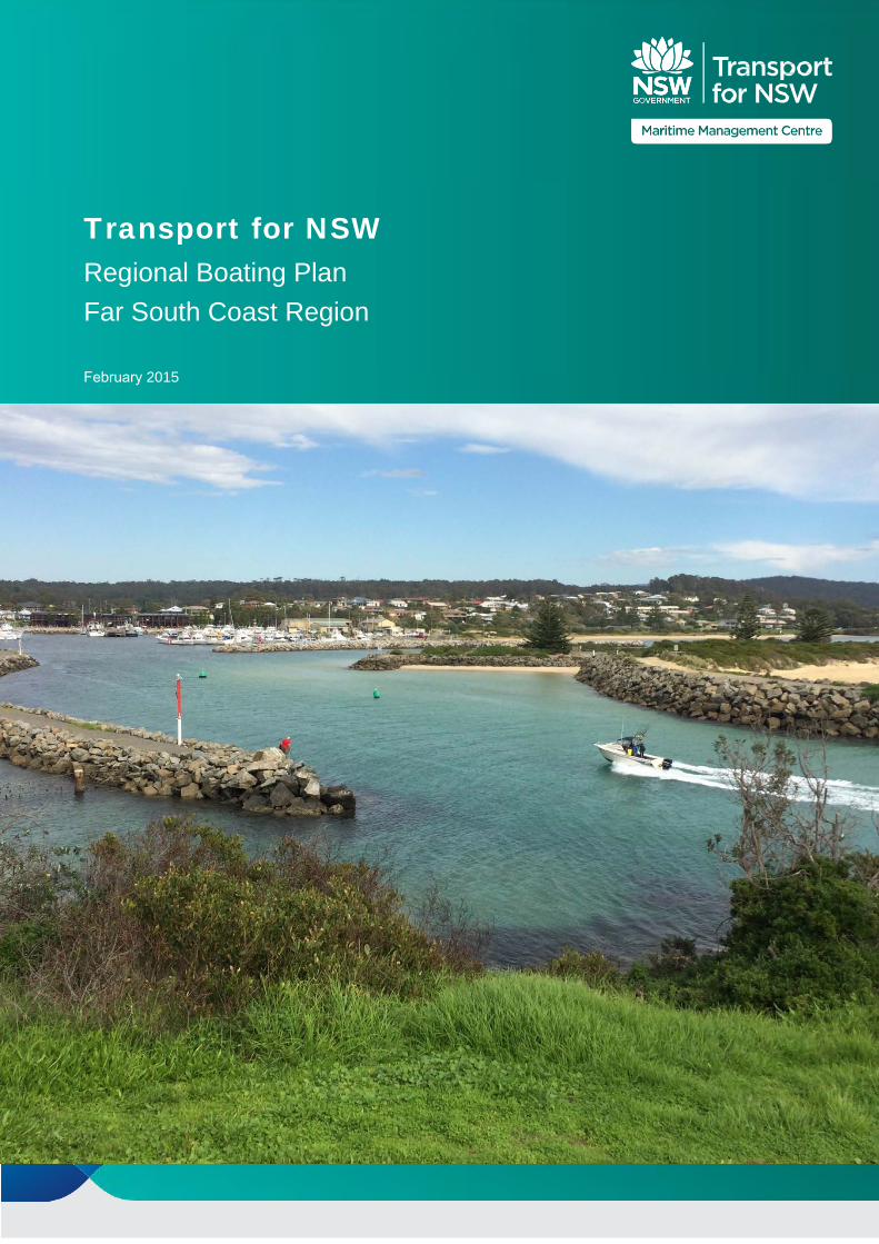
Transport for NSW Regional Boating Plan Far South Coast Region
February 2015
- - - -
Transport for NSW 18 Lee Street Chippendale NSW 2008 Postal address: PO Box K659 Haymarket NSW 1240 Internet: www.transport.nsw.gov.au Email: [email protected]
ISBN Register: 978 1 922030 68 9
© COPYRIGHT STATE OF NSW THROUGH THE DIRECTOR GENERAL OF TRANSPORT FOR NSW 2014
Extracts from this publication may be reproduced provided the source is fully acknowledged.
Report for Transport for NSW - Regional Boating Plan | i
Table of contents 1. Introduction.....................................................................................................................................4
2. Physical character of the waterways..............................................................................................6
2.1 Background..........................................................................................................................6
2.2 Clyde catchment/region .......................................................................................................7
2.3 Moruya catchment ...............................................................................................................8
2.4 Tuross catchment ................................................................................................................9
2.5 Bega catchment .................................................................................................................11
2.6 Towamba catchment..........................................................................................................13
3. Waterway users ...........................................................................................................................15
3.1 Analysis of existing user data ............................................................................................17
4. Safety ...........................................................................................................................................19
4.1 Overview of existing safety activities .................................................................................20
4.2 Complaints .........................................................................................................................21
4.3 Infringements .....................................................................................................................21
4.4 Incidents.............................................................................................................................22
4.5 Key findings .......................................................................................................................24
5. Access..........................................................................................................................................25
5.1 Overview of existing access facilities.................................................................................25
5.2 Key findings .......................................................................................................................29
6. Storage.........................................................................................................................................30
6.1 Existing storage .................................................................................................................30
6.2 Key findings .......................................................................................................................33
7. Feedback on Consultation Draft ..................................................................................................35
7.1 Feedback Summary...........................................................................................................35
8. Delivery Program .........................................................................................................................37
8.1 Summary............................................................................................................................37
8.2 NSW Boating Now Funding ...............................................................................................37
ii | Transport for NSW - Regional Boating Plan

–
–
–
–
–
–
–
–
–
–
–
–
–
–
–
Figure 5 – Bega catchment and surroundings ....................................................................................... 12
Table index
Table 1 List of grants provided to Far South Coast region through the BBP projects ........................27
Table 2 Priority Regional Projects .......................................................................................................38
Table 3 Implementation of Boating Safety, Access and Storage Actions...........................................39
Figure index Figure 1 Map of regions ........................................................................................................................5
Figure 2 Clyde catchment .....................................................................................................................8
Figure 3 Moruya catchment...................................................................................................................9
Figure 4 Tuross catchment and surroundings.....................................................................................10
Figure 6 Towamba catchment and surroundings................................................................................14
Figure 7 Infringement analysis ............................................................................................................22
Figure 8 Examples of safety issues ....................................................................................................24
Figure 9 Example access facilities within the region...........................................................................26
Figure 10 Completed BBP projects examples within the region .........................................................28
Figure 11 Examples of access issues.................................................................................................29
Figure 12 Existing storage facilities.....................................................................................................31
Figure 13 Examples of existing boat storage in region .......................................................................34
Appendices Appendix A – Maps
Report for Transport for NSW - Regional Boating Plan | iii

1. Introduction
The Far South Coast Regional Boating Plan has been developed as part of a major NSW Government initiative to boost the experience of recreational boating across the state. The Plan was developed by the Maritime Management Centre (MMC) in Transport for NSW working closely with the NSW Maritime Division of Roads and Maritime Services (Roads and Maritime) and with expert coastal infrastructure advice from consultants GHD.
The Plan identifies the boating safety, access and infrastructure actions across the regions to be implemented over the next five years. A summary of the projects and initiatives to be delivered as part of the Plan are detailed in the Delivery Program in Chapter 8. A progress report on the Delivery Program will be published annually to provide an update on the delivery of key projects and actions.
Funding for infrastructure projects will be allocated out of the NSW Boating Now program announced by the Minister for Roads and Freight in August 2014 which will see $14m per year made available for the delivery of boating infrastructure projects over the next five years.
The Plan is one of eleven Regional Boating Plans that have been developed across the major waterways in NSW as shown in Figure 1.
Each Regional Boating Plan was developed through a two-stage consultation process. The first stage involved workshops with local Councils and key stakeholder groups as well as an online survey open to all waterway users and members of the general public. Feedback received from the first stage was then used to inform the development a Consultation Draft which formed the basis of the second stage of consultation.
A public information session was held in Batemans Bay on 16 September 2014 and in Merimbula on 17 September 2014 to discuss and seek feedback on the key findings and actions identified in the Consultation Draft. Further meetings were also held with Councils to help determine the priority infrastructure projects identified in the final Plan.
4 | Transport for NSW - Regional Boating Plan

Figure 1 – Map of regions
Transport for NSW - Regional Boating Plan | 5
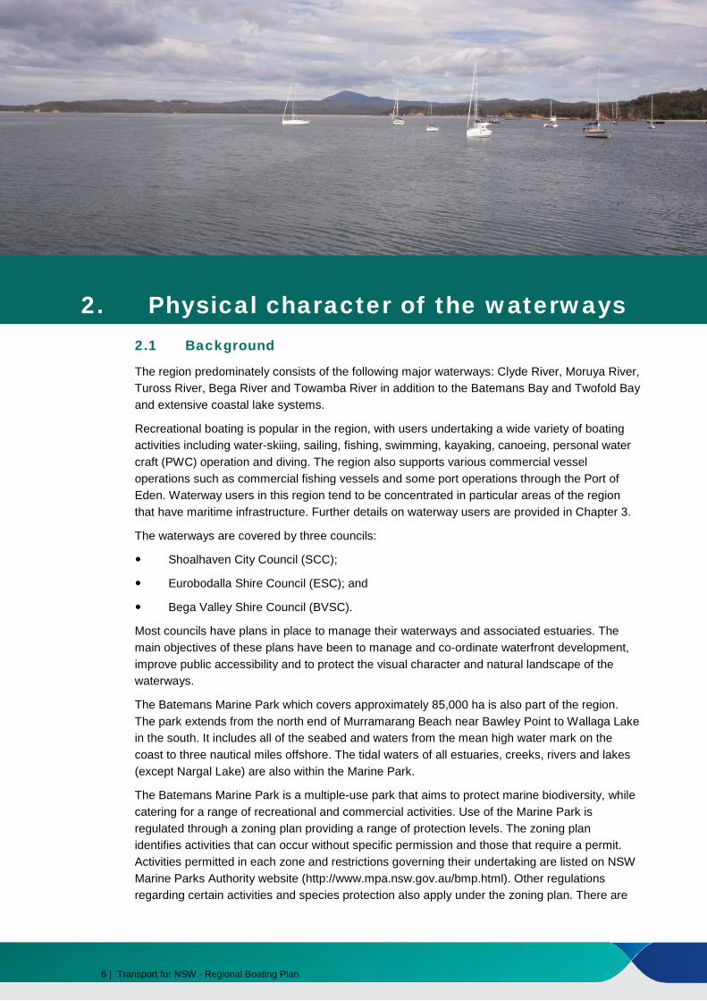
2. Physical character of the waterways 2.1 Background
The region predominately consists of the following major waterways: Clyde River, Moruya River, Tuross River, Bega River and Towamba River in addition to the Batemans Bay and Twofold Bay and extensive coastal lake systems.
Recreational boating is popular in the region, with users undertaking a wide variety of boating activities including water-skiing, sailing, fishing, swimming, kayaking, canoeing, personal water craft (PWC) operation and diving. The region also supports various commercial vessel operations such as commercial fishing vessels and some port operations through the Port of Eden. Waterway users in this region tend to be concentrated in particular areas of the region that have maritime infrastructure. Further details on waterway users are provided in Chapter 3.
The waterways are covered by three councils:
Shoalhaven City Council (SCC);
Eurobodalla Shire Council (ESC); and
Bega Valley Shire Council (BVSC).
Most councils have plans in place to manage their waterways and associated estuaries. The main objectives of these plans have been to manage and co-ordinate waterfront development, improve public accessibility and to protect the visual character and natural landscape of the waterways.
The Batemans Marine Park which covers approximately 85,000 ha is also part of the region. The park extends from the north end of Murramarang Beach near Bawley Point to Wallaga Lake in the south. It includes all of the seabed and waters from the mean high water mark on the coast to three nautical miles offshore. The tidal waters of all estuaries, creeks, rivers and lakes (except Nargal Lake) are also within the Marine Park.
The Batemans Marine Park is a multiple-use park that aims to protect marine biodiversity, while catering for a range of recreational and commercial activities. Use of the Marine Park is regulated through a zoning plan providing a range of protection levels. The zoning plan identifies activities that can occur without specific permission and those that require a permit. Activities permitted in each zone and restrictions governing their undertaking are listed on NSW Marine Parks Authority website (http://www.mpa.nsw.gov.au/bmp.html). Other regulations regarding certain activities and species protection also apply under the zoning plan. There are
6 | Transport for NSW - Regional Boating Plan

restrictions in place for recreational and commercial fishing. Anchoring is permitted in all zones except on seagrass beds in sanctuary zones.
Montague Island nature reserve also lies within the park. Both Montague Island in the south and the Tollgate Islands in the north of the marine park are aggregation sites for Grey Nurse Sharks.
The sections below outline the physical characteristics of the waterways where boating mainly occurs rather than the entire catchment and tributaries.
2.2 Clyde catchment/region
The Clyde catchment is approximately 3,260 km2 in size. The catchment boundaries fall outside of the Far South Coast region, encompassing parts of the neighbouring Shoalhaven-Illawarra region such as Sussex Inlet and Jervis Bay. The catchment is spread across two LGAs: Shoalhaven City Council and Eurobodalla Shire Council. The main waterway within the Clyde catchment relevant to the Far South Coast region is the Clyde River. It flows for approximately 102 km and develops from its source within the Budawang National Park, where the river is shallow and narrow and offers restricted navigation to an expansive open estuary between Nelligen and Batemans Bay. The estuary covers an area of approximately 18 km2 in size with an average depth of 3 m. The river passes through three national parks and ten state forests as it drops through nearly 600 m of elevation which limits access to the river and has resulted in minimal development in the catchment area.
Durras Lake is an intermittently closed coastal lagoon which is approximately 4 km2 in size and has an average depth of 1.4 m.
The Tomaga River is also within the Clyde catchment. The river begins in Mogo and extends 16 km to the ocean between Tomakin and Mossy Point. The entrance is mainly open and the rock shelf at Mossy Point dissipates wave energy allowing for sheltered access to the ocean, although navigation can be restricted across the entrance bar due to sand build up. It covers a catchment area of approximately 2 km2 in size and has an average depth of 1 m. The shallow depth, sandbars and seagrass results in restricted navigation along the waterway, especially several kilometres upstream of the entrance.
Transport for NSW - Regional Boating Plan | 7

Figure 2 – Clyde catchment
2.3 Moruya catchment
The Moruya catchment is approximately 1,550 km2 in size. It is located within the boundaries of Eurobodalla Shire Council LGA. The major waterway in the catchment is the Moruya River. It forms from the Deua River and flows for approximately 19 km through the township of Moruya to the Tasman Sea at Moruya Heads. The Moruya River entrance is trained providing a relatively stable access channel to the sea. The estuary is approximately 6 km2 in size and has an average depth of 1.9 m. Along specific stretches, the river has narrow navigation channels and sand bars that can restrict navigation. Sedimentation and siltation as well as bank erosion are ongoing issues in the estuary.
8 | Transport for NSW - Regional Boating Plan
Figure 3 – Moruya catchment
2.4 Tuross catchment
The Tuross catchment is approximately 2,180 km2 in size and includes the waterways of Coila Lake, Tuross River and Wagonga Inlet. The catchment is located within the boundaries of Eurobodalla Shire Council.
The Tuross River runs 147 km from the Great Dividing Range and has an average depth of 1.2 m. Within this waterway are a number of lakes including Tuross Lake, Borang Lake, Trunketabella Lake and Bumbo Lake. Tuross River is permanently open to the Tasman Sea and as such is tidal up to 19 km upstream of the entrance. The navigable section of the estuary has a range of shallow regions with deeper channels and basins interspersed such that vessel navigation is considered good for the majority of the waterway. However there is limited access to the ocean due to shoaling waves and moving sand bars.
Coila Lake is located just to the north of the Tuross River. It is approximately 7 km2 in size and has an average depth of 2.3 m. The lake is an intermittently closed coastal lagoon with the entrance located at the southern end of Bingie Beach.
Wagonga Inlet has an average depth of 5.7 m. Its entrance is open and trained at the town of Narooma. The inlet estuary extends approximately 9 km upstream and has several tributaries, including Billa Bilba Creek. The inlet is more navigable west of the marine delta seen at Lavender Point.
Also within the catchment are a number of small and shallow coastal lagoons and lakes. These include: Lake Brou and Lake Mummuga.
Transport for NSW - Regional Boating Plan | 9
Figure 4 – Tuross catchment and surroundings
10 | Transport for NSW - Regional Boating Plan

2.5 Bega catchment
The Bega catchment is approximately 2,850 km2 in size and includes: Bega River, Bermagui River, Wallaga Lake and Wallagoot Lake. The catchment is almost entirely within Bega Valley Shire Council, with the northern area including Wallaga Lake falling into the Eurobodalla Shire Council LGA.
Wallaga Lake is approximately 9 km2 in size and has an average depth of 3.7 m. The lake is generally open to the Tasman Sea but it is only minimally affected by tides.
The Bermagui River is approximately 2 km2 in size and has an average depth of 1.1 m. The river entrance is trained and as such the waterway is tidal. Upstream, the river extends 7 km to its source at the confluence of Coolagolite Creek and Nutleys Creek. Despite being a relatively shallow waterway, the Bermagui River is navigable for approximately 5 km from the entrance. Bermagui harbour is located in the catchment. This is well sheltered allowing for vessel refuge and relatively good access to the ocean.
The Bega River has an average depth of 1.9 m and flows for approximately 47 km from Moran’s Crossing to Mogareeka Inlet which is intermittently open to the Tasman Sea. Bega River’s major tributary is the Brogo River, which joins just north of Bega. Upstream of the Brogo River is the Brogo Dam which is used for hydro-power generation, environmental flows, water supply and irrigation.
Wallagoot Lake is approximately 4.0 km2 in size and has an average depth of 1.4 m. The Lake’s entrance is intermittently open to the Tasman Sea, however, access is generally constrained.
Other waterways in the Bega catchment include: Kianinny Bay, Baragoot Lake, Cuttagee Lake, Murrah Lagoon, Wapengo Lagoon, Middle Lagoon, and Nelson Lagoon.
Transport for NSW - Regional Boating Plan | 11

Figure 5 – Bega catchment and surroundings
12 | Transport for NSW - Regional Boating Plan

2.6 Towamba catchment
The Towamba catchment is approximately 2,350 km2 in size. Major waterways include the Towamba River, Twofold Bay, Merimbula Lake, Pambula River and the Wonboyn River. The catchment is located entirely within the Bega Valley Shire Council LGA.
Merimbula Lake is approximately 6 km2 in size and has an average depth of 2.6 m. An inlet channel runs from the sea through to the lake hence the waterway is tidal. The southern end of the lake is relatively shallower and has a sandy shoreline with mangroves, whilst the northern end is deeper has a relatively rocky shoreline.
Pambula River is approximately 5 km2 in size and has an average depth of 2.2 m. The river is 15 km long and flows into Pambula Lake before then continuing to the Tasman Sea through an open channel at Pambula Beach.
The Towamba River has an average depth of 1.1 m. The river begins in the Great Dividing Range and reaches the Tasman Sea at Twofold Bay approximately 86 km from its source. Whilst providing a reasonable average depth, the river is largely unnavigable due to its remote access and relatively large drop in elevation.
Twofold Bay, which is an ocean embayment on the southern side of Eden, is one of the most extensively used waterways in the Far South Coast region. The bay is approximately 31 km2 in size and has an average depth of 10.9 m. Due to its average depth, the waters of Twofold Bay provide good navigation. However it is exposed during certain weather and ocean conditions and the waters can be rough in large swells and strong winds (particularly during strong southern and south-westerly winds and for Quarantine Bay, South-Easterly and North-Easterly winds).
The Wonboyn River has an average depth of 2.7 m. It is a relatively large and sheltered estuary open to the ocean. The Wonboyn River is sourced from the confluence of the Narrabarba Creek and Watergums Creek, 18 km from the entrance. Despite a modest average depth, a range of oyster farms and areas of shallower waters provide navigational hazards.
Transport for NSW - Regional Boating Plan | 13
Figure 6 – Towamba catchment and surroundings
14 | Transport for NSW - Regional Boating Plan

3. Waterway users
Recreational boating is a popular activity in the Far South Coast regional waterways. The waterways are popular among recreational fishers and an increasing number of visiting boaters from the Australian Capital Territory (ACT) and Victoria particularly during holiday periods. Other common boating activities in the region include water-skiing, wake boarding, PWC operation, sailing, rowing, canoeing and kayaking.
Clyde catchment/region
The Clyde catchment is mainly used for the following recreational activities:
Recreational fishing throughout the catchment’s waterways including around the popular Tollgate Islands;
Cruising and sailing in Batemans Bay and the lower Clyde River;
PWC riding;
Non-powered craft use including kayaks, canoes and surf-skis on the Clyde River, Tomaga River and Durras Lake;
Tow sports in the Clyde River between Nelligen and Currowan Creek and between Razorback Rock and Batemans Bay;
Houseboating on the Clyde River around Nelligen;
Swimming;
Snorkelling and diving throughout the Batemans Marine Park, especially Durras Lake Entrance Reef and Depot Beach; and
Major events include fishing competitions, sailing regattas and the Batemans Bay Marine Show.
In addition to these recreational activities, the Clyde catchment also accommodates a number of commercial activities including a number of marinas, 39 fishing businesses, five hire and drive businesses, two commercial passenger vessels and four work or utility operators in 2009. In addition, commercial fishing and charter operations have a presence and operate mainly out of Batemans Bay. Oyster farming is common on the lower Clyde River and also along the Tomaga River.
Transport for NSW - Regional Boating Plan | 15

Moruya catchment
The Moruya catchment is mainly used for the following recreational activities on the Moruya River:
Fishing, water-skiing, wakeboarding and cruising on small runabouts;
PWC operation;
Sailing; and
Non-powered craft use in the form of kayaks, canoes and surf-skis.
Commercial activity is limited in the Moruya catchment. Oyster farming on the Moruya River is also undertaken.
Tuross catchment
The Tuross catchment is mainly used for the following recreational activities:
Snorkelling and diving at Montague Island (off Narooma);
Recreational fishing, especially in Tuross Lake as a result of a commercial fishing ban, and the eastern fringes of Wagonga Inlet;
Prawning in Coila Lake;
Swimming in the vicinity of the Tuross River entrance;
Tow sports and PWCs in Tuross River and adjoining lakes (excluding Tuross Lake due to eight knot speed restriction), Wagonga Inlet and Corunna Lake;
PWC operation;
Non-powered craft use on Tuross Lake, Coila Lake, Lake Mummuga and Wagonga Inlet; and
Sailing is common around the Wagonga Inlet, but very limited on Tuross Lake and Coila Lake.
In addition to these recreational activities, the Tuross catchment also accommodates a number of commercial activities, especially in Narooma due to good ocean access. Commercial offshore fishing, scuba diving, whale watching trips and Montague Island tours are popular, especially during peak periods. In addition, the oldest operating ferry in Australia, the Wagonga Princess, operates within Wagonga Inlet and has been in operation for over 100 years. Oyster farming is carried out on the Tuross River and surrounding lakes, and in Wagonga Inlet.
Bega catchment
The Bega catchment is mainly used for the following recreational activities:
Fishing on Wallaga Lake, Bega River, Bermagui River and south of Wallagoot Lake;
Australian Bass fishing in Brogo Dam, including regular fishing competitions;
Water-skiing in Bega River and also in Wallaga Lake but confined to certain channels and basins due to ranging water depths;
Non-powered craft use on Wallaga Lake, Wallagoot Lake, Brogo Dam and Bega River
PWC operation;
Sailboarding in Bega River and Wallagoot Lake; and
Swimming in Bega River at Mogareeka Inlet, Kianinny Bay and Wallagoot Lake as well as the numerous beaches in the catchment.
16 | Transport for NSW - Regional Boating Plan
In addition to these recreational activities, the Bega catchment also accommodates a number of commercial activities. The town of Bermagui is regarded as one of the best boating harbours in the region due to training breakwaters that provide good ocean access. As a result, the harbour is used by an extensive commercial fishing fleet. Wallaga Lake has a small contingency of oyster farming and prawn harvesting, however fishing is the primary source for commercial activities on the lake.
Towamba catchment
The majority of the population in this catchment is located within the coastal towns of Merimbula, Pambula and Eden. The population of these towns increase several fold during summer holidays resulting in increasing waterway usage for recreational purposes. The Towamba catchment is mainly used for the following recreational activities:
Recreational fishing in particular on the Wonboyn River, Towamba River, Merimbula Lake, Pambula Lake and in Twofold Bay;
Swimming and snorkelling in Pambula River, Merimbula Lake, Cocora Beach and Asling Beach;
Sailboarding in Merimbula Lake;
Sailing in Twofold Bay;
PWC operation;
Windsurfing on the Pambula River;
Wakeboarding and water-skiing in Pambula River;
Non-powered craft use on the Merimbula Lake, Pambula River and in Twofold Bay; and
Scuba diving in Twofold Bay.
In addition to these recreational activities, the Towamba catchment also accommodates a number of commercial activities. Popular charters that operate out of Eden as well as Merimbula include reef and deep sea fishing, and dolphin and whale watching in season. In addition, oyster farming is carried out in Merimbula, Pymble Lakes and Twofold Bay as well as along the Wonboyn River.
The Port of Eden located in Twofold Bay, is the southernmost major port on the NSW coast and is used by naval vessels, cruise ships, charter vessels, commercial fishing boats, Bass Strait oil and gas industries and is also a major exporter of timber logs and woodchips.
Two major initiatives are underway at Eden which could have a significant impact on the future of the Port as both a destination for cruise ships and for recreational and commercial vessels. The Federal Government has allocated $10 million and the NSW Government has allocated $3 million towards the extension of the breakwater wharf to enable the port to accommodate larger cruise ships. In addition, the NSW Government recently announced $10 million in state funding towards improving safety and amenity for recreational and small commercial vessels within the Port of Eden. Both projects are being lead by the NSW Trade and Investment (Crown Lands) in conjunction with other relevant agencies, including Transport for NSW and Roads and Maritime.
3.1 Analysis of existing user data
3.1.1 Licence data analysis
An analysis of the 2011 census (between 2006 and 2011) of the LGAs in this region has revealed the following:
Transport for NSW - Regional Boating Plan | 17
Eurobodalla Shire Council had a population of 35,741 and experienced a population growth of 2.1%; and
Bega Valley Shire Council had a population of 31,950 and experienced a population growth of 2.9%.
The population growth of the two major LGAs that make up the Far South Coast region is below both the national average growth of 8.32% and the NSW average of 5.63%.
There are currently approximately 7,000 boat licence holders in the Far South Coast region. This represents approximately 1.3% of all boat licence holders in NSW. There are also a significant number of boaters from the ACT, Victoria and other parts of NSW that visit the area.
The majority of licence holders in the region carry a General Boat Licence with approximately 5% licensed to operate PWCs. This breakdown of licence types is dissimilar to the State average in that there are a lower proportion of PWC licenses.
3.1.2 Registration data analysis
There are approximately 4,400 registered recreational vessels in the Far South Coast region. This represents approximately 1.9% of all registered vessels in NSW. It is important to note that there are smaller boats that may not require licences to use the waterways as well as visiting boats from the ACT.
Open runabouts dominate, accounting for 77% of all registered vessels. Cabin runabouts are also popular, comprising 12% of all vessels. Motor cruisers, yachts, PWCs, and powered catamarans are also registered in the region but these represent a relatively small proportion of the region’s total registered vessels.
A majority (89%) of all vessels are below 6 m in length and the average vessel length for the region is 4.8 m. Vessels less than 6 m in length are defined as trailerable. This has a strong influence on the boating access and storage requirements in the region with a strong demand on boat ramps and trailer parking.
3.1.3 Other users
Whilst the data analysed above provides information on licence holders and vessels registered in the Far South Coast region, it does not capture boaters from other regions, in particular from the ACT, and Victoria, as well as transiting vessels travelling interstate or internationally , which can add to the local demand at certain times of the year.
Roads and Maritime’s licence and registration data does not capture non-powered craft such as kayaks, canoes, rowing or other beach-launch and sail craft, which do not require registration. Based on the estimated total number of these vessel types in NSW, there may be significant numbers of these vessels in the Far South Coast region.
3.1.4 Future demand
In 2010, the then NSW Maritime released a report titled NSW Boat Ownership and Storage Growth Forecasts to 2026. The report forecast a continuing growth trend in vessel ownership of 2.9% annually across NSW.
The Report used a different regional profile to that being used for the Regional Boating Plan. It identified that the South Coast region (which incorporates both the Shoalhaven – Illawarra region and the Far South Coast region) has experienced the second largest growth in the State. Despite this growth (approximately 3.9% per annum across all boat sizes), the South Coast region has the third smallest proportion of boats greater than 6 m in length. This growth pattern is important to consider in future decisions on storage and access requirements for the region.
18 | Transport for NSW - Regional Boating Plan

4. Safety
Key findings
• Stakeholder consultation suggests high levels of satisfaction with current boating safety measures in the region.
• The Far South Coast region has low to moderate waterway usage; however, waterway usage becomes considerably higher during peak periods.
• A lack of knowledge of the waterways by visitors and the many first time boaters using hire and drive vessels and non-powered craft, were highlighted as an issue.
• The large proportion of capsizing incidents in the region (nearly 25%) compared to the State average of 12% may be due to the extensive use of coastal waters, the significant proportion of small runabouts in the region and the number of bar crossings incidents in the region.
• Some stakeholders identified access and safety issues regarding the bar crossings at Pambula, Moruya River, Narooma and Merimbula.
• A review of signage, navigation aids and education would help enhance boating safety and the overall boating experience.
Actions
a. Review strategies to improve on-water behaviour and safe boating practices across the region
b. Review the placement and planning of navigations aids and signage to improve navigation where appropriate
c. Review strategies to improve safe vessel operation in open and offshore waters, when crossing ocean bars and when operating in isolated or remote waters
Transport for NSW - Regional Boating Plan | 19
4.1 Overview of existing safety activities
The MMC has led a successful campaign with Roads and Maritime to promote the wearing of lifejackets, especially in small vessels. The campaign is a response to the fact that 9 out of 10 people who drown when boating, are not wearing a lifejacket.
The campaign has been the most comprehensive, targeted program on boating safety in NSW history. It included an extensive advertising campaign, an innovative mobile lifejacket promotional van which took the safety message to the boating public State-wide (including visits to the Far South Coast), a zero tolerance on-water compliance approach and a host of supporting and educational activities
Roads and Maritime is responsible for the operational delivery of marine safety in NSW, including the operational aspects of the regulation of recreational and commercial boating activity throughout the State. The enforcement role is chiefly performed by BSOs who conduct regular on-water patrols and inspections throughout the Far South Coast region waterways to provide boating safety education and ensure compliance with safety requirements (such as lifejackets), speed, wash, distance off, aquatic licences, commercial operations and mooring requirements. Boating safety education is also provided by Roads and Maritime Boating Education Officers (BEOs) throughout the State.
Roads and Maritime also operate a Mobile Safety Education and Compliance Team which is a team of specialist BSOs who can be deployed throughout NSW.
The BSOs work in close partnership with the local NSW Police Force (both general duties police and the local Marine Area Command) often conducting joint patrols, although police officers are solely responsible for conducting random breath testing on NSW navigable waters.
BSOs also work in partnership with officers of the Department of Primary Industries (Fisheries) and National Parks’ rangers in relation to matters of common interest.
In addition to State-wide regulatory requirements and boating safety campaigns, specific boating safety restrictions that apply in the Far South Coast region are shown on the map included in Appendix A and online at http://www.rms.nsw.gov.au/maritime/usingwaterways/maps/boating-maps.html. These are summarised as follows:
• Speed restrictions such as:
– 4 knot zones, specifically at:
Batemans Bay Boat Harbour;
Tomaga River;
Tuross River near Cambathin Island;
Upstream Wagonga Inlet;
Quarantine Bay, Eden;
Kianinny Bay;
Curalo Lagoon;
River and creek entrances such as Durras Lake, Wagonga Inlet, Bermagui River and Wonboyn River;
Creeks such as McLeods Creek and Congo Creek; and
Forsters Bay in Wagonga Inlet.
– 8 knot zones at Tuross Lake, Merimbula River entrance, Bega River entrance and Brogo Dam.
20 | Transport for NSW - Regional Boating Plan

• “no wash” and “no towing” zones.
Further controls exist in the NSW maritime legislation, including the International Regulations for Preventing Collisions at Sea. These include but are not limited to:
• The skipper (master of the vessel) is responsible for the safety of the vessel and all people on board;
• The skipper must always:
– keep to a safe speed for the conditions (eg., slower speeds at times of reduced visibility, rough water, congested waterway);
– keep a proper lookout;
– be prepared to take action to avoid a collision; and
– display appropriate navigation lights at night.
In addition, there are also a number of general “distance off” restrictions which apply on all NSW waters – for example, vessels travelling at 10 knots or more must remain at least 60 m from people in the water and 30 m from structures, shorelines and other powered vessels. Where it is not possible to maintain the specified distances, a “safe distance” should be maintained. This is the distance which will ensure that a vessel will not endanger or injure people or damage property, having regard to relevant factors such as prevailing weather conditions, visibility, speed and any obstructions.
4.2 Complaints
Analysis of the complaints received by Roads and Maritime during the 5 years leading up to 1 January 2014 reveals that the majority of complaints received related to:
navigation hazards (32%);
irregular riding of personal water craft (16%); and
speeding (12%).
The most significant number of complaints received by the Roads and Maritime for the Far South Coast region related to the popular Batemans Bay area (25%). Other common areas were the Moruya River, Merimbula and Narooma (totalling to 40%).
4.3 Infringements
Between 2009 and 2013, the number of penalty notices issued within the Far South Coast region accounted for 5.3% (approximately 650) of all infringement notices issued throughout NSW, which is higher than the region’s proportion of all boat licence holders in NSW (1.3%). Of the penalties issued over the five year period, approximately 83% were by Roads and Maritime, whilst the remainder were issued by NSW Police. In addition to these penalties, 1,153 formal warnings were issued.
The highly trafficked waters of the Clyde River, including Batemans Bay, accounted for 38% of the region’s infringements.
As indicated in Figure 7 below, the infringements for which the most penalty notices were issued in the region were for:
failure to carry the correct safety equipment including life jackets (66%);
excessive speed (11%);
negligent navigation (6%); and
licensing (6%)
Transport for NSW - Regional Boating Plan | 21

Figure 7 – Infringement analysis
0
50
100
150
200
250
300
350
400
Num
ber o
f Inf
ringe
men
t Not
ices
Issu
ed
Category of Infringement
4.4 Incidents
In the period between 1 January 2009 and 31 December 2013, there were 61 vessel incidents reported to Roads and Maritime in the region. Eighteen incidents occurred in the Clyde catchment, 14 in the Towamba catchment, nine in the Tuross catchment, three in the Bega catchment, one in the Moruya catchment and another 16 incidents offshore. Forty-eight of the incidents involved recreational vessels and ten involved commercial vessels. Three incidents involved an interaction between a recreational and commercial vessel.
4.4.1 Incidents resulting in death or injury
Five fatal incidents have occurred in the region between 2009 and 2013. All but one of these incidents involved recreational vessels and all took place in daylight hours. Four of the incidents involved small open runabouts while the remaining incident involved a sailing vessel. Three of the incidents were caused by behavioural factors, that is, no proper lookout or lack of judgment. Seven of the nine deceased were not wearing an appropriate lifejacket.
There were also 12 incidents which resulted in serious injury to the victim. A serious injury is classified as one requiring hospitalisation or outpatient treatment. These incidents resulted in 12 injuries with no particular trend in causes. Five of these incidents involved a PWC and four serious injuries were caused by hazardous waters. An additional 11 incidents resulted in minor injury to 17 persons; four of these incidents were caused by a lack of judgment.
4.4.2 Types of vessels
The main types of vessels involved in incidents, where known, were small powered craft (open runabouts 40%, cabin runabouts 8%), PWC (15%), sailing vessels (10%), larger motor cruisers (8%) and inflatables (6%).
4.4.3 Incident locations
Vessel incidents were concentrated in the following locations.
12 incidents in Batemans Bay;
Eight incidents in Twofold Bay;
22 | Transport for NSW - Regional Boating Plan

Five incidents in Merimbula Lake; and
Five incidents in Wagonga Inlet.
4.4.4 Incident cause
Behavioural and environmental factors were identified as the primary cause of the majority of incidents. Eleven incidents were the result of a lack of judgment, eight incidents were attributable to no proper lookout, eight to hazardous waters, seven incidents were the result of weather, three were attributable to bar conditions and three were caused by tidal conditions. Material factors involving failure of a variety of machinery, electronics or equipment were attributable to five incidents.
4.4.5 Incident type
The composition of incident types in the region was considerably different to State-wide averages. The most common type of incident in this region was vessel capsize (15 incidents), which is approximately 25% of the total incidents. This is a significantly greater proportion than the State-wide average of approximately 12%.
The next most common type of vessel incidents observed in the region were collisions with other vessels (9), sinking (6) and grounding (6). While there were a number of incidents such as fall overboard (5) and bar crossing incident (4) which had serious consequences, no other incident types registered more than three incidents.
4.4.6 Time of day, month and year
Where the time of the incident is known, most incidents occurred during the day with fifteen recorded at night. Most incidents occurred during the peak boating periods, on weekends between January and June. January was the main month when incidents occurred, corresponding to the heaviest period of boating activity, although March, April, May and June had the significant contributions. This period which corresponds to the pelagic fish migration attracts a considerable number of boaters to the region including commercial fishing vessels. A relatively small proportion occurred in November, December and February.
4.4.7 Wind and weather
During consultations, anecdotal evidence was provided suggesting that the river and lake entrances can be subject to rapidly changing weather and tidal conditions. In addition, open waterways with a large fetch such as Twofold Bay can develop choppy conditions with strong winds. Of the incidents where the weather conditions are known, approximately three quarters of the incidents occurred where water conditions were described as choppy, rough, or very rough.
4.4.8 Bar crossings
There are a number of bar crossings, inlets and exposed harbour entrances in this region. As noted in Section 4.4.5, bar crossing is a common cause of boating incidents in this region. Despite the large proportion of bar crossing incidents, there have been no fatal incidents directly attributable, suggesting a positive impact from the introduction of compulsory lifejacket requirements for bar crossings in 2003 and the roll out of bar crossing cameras. Bar crossings and management strategies are investigated further in Chapter 8.
Transport for NSW - Regional Boating Plan | 23
4.5 Key findings
The consultation feedback suggests that boaters in the Far South Coast region generally have a positive view about safety on the region’s waterways. However, Roads and Maritime will need to continue to actively manage safety on the waterways through its compliance activities and education campaigns.
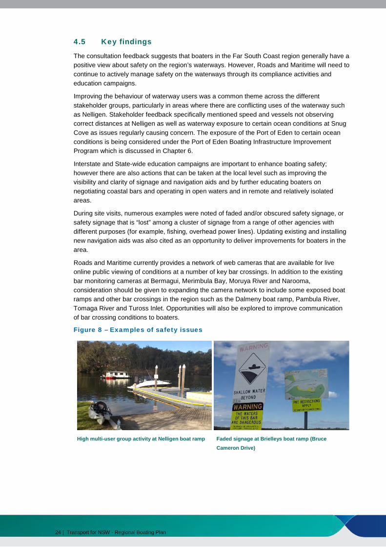
Improving the behaviour of waterway users was a common theme across the different stakeholder groups, particularly in areas where there are conflicting uses of the waterway such as Nelligen. Stakeholder feedback specifically mentioned speed and vessels not observing correct distances at Nelligen as well as waterway exposure to certain ocean conditions at Snug Cove as issues regularly causing concern. The exposure of the Port of Eden to certain ocean conditions is being considered under the Port of Eden Boating Infrastructure Improvement Program which is discussed in Chapter 6.
Interstate and State-wide education campaigns are important to enhance boating safety; however there are also actions that can be taken at the local level such as improving the visibility and clarity of signage and navigation aids and by further educating boaters on negotiating coastal bars and operating in open waters and in remote and relatively isolated areas.
During site visits, numerous examples were noted of faded and/or obscured safety signage, or safety signage that is “lost” among a cluster of signage from a range of other agencies with different purposes (for example, fishing, overhead power lines). Updating existing and installing new navigation aids was also cited as an opportunity to deliver improvements for boaters in the area.
Roads and Maritime currently provides a network of web cameras that are available for live online public viewing of conditions at a number of key bar crossings. In addition to the existing bar monitoring cameras at Bermagui, Merimbula Bay, Moruya River and Narooma, consideration should be given to expanding the camera network to include some exposed boat ramps and other bar crossings in the region such as the Dalmeny boat ramp, Pambula River, Tomaga River and Tuross Inlet. Opportunities will also be explored to improve communication of bar crossing conditions to boaters.
Figure 8 – Examples of safety issues
High multi-user group activity at Nelligen boat ramp Faded signage at Brielleys boat ramp (Bruce
Cameron Drive)
24 | Transport for NSW - Regional Boating Plan

5. Access
Key findings
• There are a relatively limited number of waterway access points in the Far South Coast region, however these facilities support a region of relatively low population density. There are also a number of informal access points used by many local boaters that provide further waterways access in the region.
• Many existing access points would benefit from an upgrade and the provision of a range of additional amenities, especially at regionally significant locations.
• More than 60% of online survey respondents believe that waterway access is acceptable in the region with 35% being either dissatisfied (23%) or very dissatisfied (12%).
• Access infrastructure at some locations does not meet demand during peak periods and generally has poorly organised and insufficient trailer parking facilities.
• Strategic placement of additional facilities and amenities and courtesy moorings in certain locations may help to create destinations that attract visiting boaters to the region
• There was strong feedback supporting the installation of a sewage pump out facility at Batemans Bay.
Actions
d. Work with councils and other partners to improve the condition and capacity of existing boat ramps
e. Work with councils and other agencies to enhance access options such as jetties and pontoons at strategic locations and amenities such as sewage pump-outs
f. Continue support for the Rescuing Our Waterways dredging program
5.1 Overview of existing access facilities
Vessels access the waterways of the Far South Coast region in several ways including boat ramps, private and commercial moorings, marina berths and club or private landing facilities. Trailered vessels can be launched and retrieved at public boat ramps, some of which have public facilities available such as trailer parking, fish cleaning tables and toilets. Some public wharves and jetties are also located on the region’s waterways and provide alternate access to vessels that are on the water. Informal dinghy storage facilities are used to access moored vessels. Some waterfront landowners also gain direct access to the waterway through private vessel launching facilities. There is also informal access for smaller vessels (such as canoes and kayaks) from a number of public reserves and beaches.
Transport for NSW - Regional Boating Plan | 25
During the site visits, some of the ramps visited were visually identified to be in need of repair or upgrade, poorly maintained and lacking amenities and access facilities. Further details on some specific improvements to boating access upgrades are provided at Chapter 8.
Boat ramps
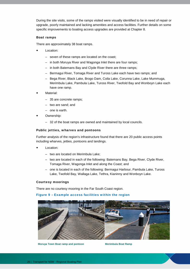
There are approximately 38 boat ramps.
Location:
– seven of these ramps are located on the coast;
– in both Moruya River and Wagonga Inlet there are four ramps;
– in both Batemans Bay and Clyde River there are three ramps;
– Bermagui River, Tomaga River and Tuross Lake each have two ramps; and
– Bega River, Black Lake, Brogo Dam, Coila Lake, Corunna Lake, Lake Mummuga, Merimbula Lake, Pambula Lake, Tuross River, Twofold Bay and Wonboyn Lake each have one ramp.
Material:
– 35 are concrete ramps;
– two are sand; and
– one is earth.
Ownership:
– 32 of the boat ramps are owned and maintained by local councils.
Public jetties, wharves and pontoons
Further analysis of the region’s infrastructure found that there are 20 public access points including wharves, jetties, pontoons and landings.
Location:
– two are located on Merimbula Lake;
– two are located in each of the following: Batemans Bay, Bega River, Clyde River, Tomaga River, Wagonga Inlet and along the Coast; and
– one is located in each of the following: Bermagui Harbour, Pambula Lake, Tuross Lake, Twofold Bay, Wallaga Lake, Tethra, Kianinny and Wonboyn Lake.
Courtesy moorings
There are no courtesy mooring in the Far South Coast region.
Figure 9 – Example access facilities within the region
Moruya Town Boat ramp and pontoon Merimbula Boat Ramp
26 | Transport for NSW - Regional Boating Plan

5.1.1 Better Boating Program grants
Through the Better Boating Program, Roads and Maritime has provided 26 grants totalling approximately $1.6 million for 21 projects in the Far South Coast region between 2004/05 and 2013/14. A selection of these can be seen in Figure 10 with all projects listed in Table 1 below. It is important to note that the total cost of the projects is not depicted in this table. For total cost of the projects refer to http://www.rms.nsw.gov.au/projects/key-build-program/better-boatingprogram/index.html.
Table 1 – List of grants provided to Far South Coast region through the BBP projects
Recipient Project Final Grant
Bega Valley Shire Council Bega Valley Boating Infrastructure Plan $10,000 Bega Valley Shire Council Merimbula Lake Boat Ramp Upgrade &
New Pontoon $42,625
Bega Valley Shire Council Merimbula Lake Boat Ramp Upgrade & New Pontoon (Additional Funding 1)
$137,355
Bega Valley Shire Council Merimbula Lake Boat Ramp Upgrade & New Pontoon (Additional Funding 2)
$70,370
Bega Valley Shire Council Merimbula Town Wharf Reconstruction $100,000 Bega Valley Shire Council Merimbula Town Wharf Reconstruction
(Additional Funding) $123,000
Bega Valley Shire Council Mogareeka Boat Ramp Pontoon Reconstruction
$33,772
Bega Valley Shire Council Shire-wide General Boat Ramp Upgrade, Bega Valley
$50,000
Bega Valley Shire Council Wonboyn Lake Boat Ramp & Jetty Upgrade, Wonboyn
$245,000*
Bombala Council Black Lake Boat Ramp Precinct Upgrade, Bibbenluke
$49,250
Eurobodalla Shire Council Apex Park Boat Ramp Pontoon, Narooma (Wagonga Inlet)
$100,000*
Eurobodalla Shire Council Batemans Bay Regional Waterways Infrastructure Plan
$30,000*
Eurobodalla Shire Council Cresswick Cove Boat Ramp, Dalmeny $50,000 Eurobodalla Shire Council Hanging Rock Boat Ramp Pontoon,
Batemans Bay $50,000
Eurobodalla Shire Council Hanging Rock Boat Ramp Pontoon, Batemans Bay (Additional Funding)
$68,000
Eurobodalla Shire Council Moruya Town Wharf $39,953 Eurobodalla Shire Council Moruya Town Wharf Pontoon $41,000 Eurobodalla Shire Council Moruya Town Wharf Pontoon (Additional
Funding) $48,000
Eurobodalla Shire Council Moruya Town Wharf Upgrade $70,000 Eurobodalla Shire Council Mosquito Bay Ramp Upgrade - Lilli Pilli $53,215 Eurobodalla Shire Council Nelligen Wharf Pontoon - Clyde River $7,950 Eurobodalla Shire Council Old Punt Road Boat Ramp Upgrade (Stage
1), Batemans Bay $75,000
Transport for NSW - Regional Boating Plan | 27

Recipient Project Final Grant
Eurobodalla Shire Council The Loop Boat Ramp Replacement, $33,977 Narooma
Eurobodalla Shire Council Tuross Head Boat Ramp Relocation $15,000 (Investigation & Design)
Eurobodalla Shire Council Tuross River Bridge Boat Ramp $15,000 Replacement, Bodalla
TOTAL $1,558,467
* denotes Active projects as of 11/11/2014
Figure 10 – Completed BBP projects examples within the region
Mogareeka Boat Ramp Pontoon Moruya Town Wharf
Hanging Rock Boat Ramp New Pontoon, Batemans Bay Merimbula Town Jetty
28 | Transport for NSW - Regional Boating Plan
5.2 Key findings
The Far South Coast region has a reasonably limited number of formal boating access points given the length of the coastline and the number of other waterways it covers. These access facilities are supplemented by a number of informal access points used by many local boaters. While the region has a relatively low population density, during peak tourist seasons, the region sees a significant influx of boaters from the ACT, Victoria and other parts of NSW. There are numerous opportunities to upgrade the condition of existing facilities that will enhance the boating experience and also assist these existing facilities in meeting peak demand in the region.
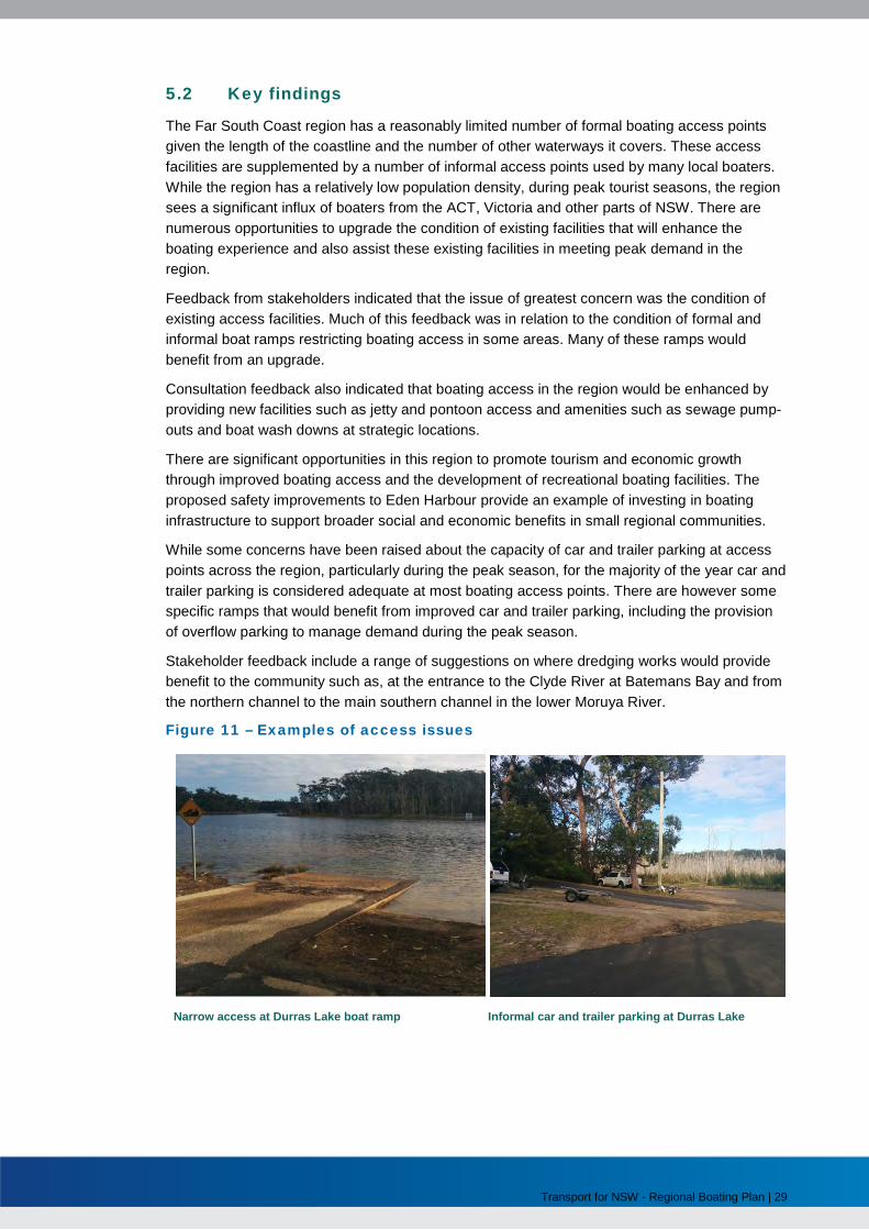
Feedback from stakeholders indicated that the issue of greatest concern was the condition of existing access facilities. Much of this feedback was in relation to the condition of formal and informal boat ramps restricting boating access in some areas. Many of these ramps would benefit from an upgrade.
Consultation feedback also indicated that boating access in the region would be enhanced by providing new facilities such as jetty and pontoon access and amenities such as sewage pump-outs and boat wash downs at strategic locations.
There are significant opportunities in this region to promote tourism and economic growth through improved boating access and the development of recreational boating facilities. The proposed safety improvements to Eden Harbour provide an example of investing in boating infrastructure to support broader social and economic benefits in small regional communities.
While some concerns have been raised about the capacity of car and trailer parking at access points across the region, particularly during the peak season, for the majority of the year car and trailer parking is considered adequate at most boating access points. There are however some specific ramps that would benefit from improved car and trailer parking, including the provision of overflow parking to manage demand during the peak season.
Stakeholder feedback include a range of suggestions on where dredging works would provide benefit to the community such as, at the entrance to the Clyde River at Batemans Bay and from the northern channel to the main southern channel in the lower Moruya River.
Figure 11 – Examples of access issues
Narrow access at Durras Lake boat ramp Informal car and trailer parking at Durras Lake
Transport for NSW - Regional Boating Plan | 29

6. Storage
Key findings
• The growth in boat storage capacity across the region will need to keep pace with the forecast growth in vessel numbers.
• Stakeholders expressed the need for both on water storage and dry storage to be strategically located in the region to support storage as well as employment, tourism and the economy generally.
• Stakeholder feedback highlighted the need to progress increased on-water storage at Batemans Bay and Eden in particular.
Actions
g. Work with Crown Lands, Councils and other partners to help deliver projects that support strategic growth in boat storage capacity and improve harbour storage facilities including at Eden and Batemans Bay
6.1 Existing storage
6.1.1 Overview of existing storage types
Storage for vessels is generally provided on-land for smaller trailerable vessel (< 6 m) and on-water for larger vessels (> 6 m); however larger vessels can also be stored on-land, for example at dry-storage facilities, for vessels up to approximately 10 m.
The main types of on-water storage in the Far South Coast region are:
Private moorings;
Commercial moorings;
Commercial marina berths; and
Domestic berths, moorings and other associated storage.
30 | Transport for NSW - Regional Boating Plan

On-water storage at commercial marinas, yacht / sailing clubs, or boating facilities, is provided through berths (floating or fixed), moorings (swing, fore and aft or other) and where space permits on-land, through dry storage such as a hard-stand or dry-stack. Examples are shown below at Figure 12.
Figure 12 – Existing storage facilities1
Marina pontoons being installed at Bermagui Batemans Bay boat harbour and marina
Tuross Boatshed and café – hire and drive storage Merimbula private storage
Storage at private facilities can be adjacent to private property on domestic jetties, slipways, boatsheds, berths/fore and aft moorings, or, on private swing moorings. Private swing moorings usually also require access to the water with a tender/dinghy and this vessel also requires its own form of storage on-land.
Vessels less than 6 m are most often stored on private property or residential streets on trailers and access the water via boat ramps.
6.1.2 Overview of existing storage volume
It is estimated there are approximately 1,000 storage spaces on-water or at associated land facilities in the region. Of these, approximately 400 are private moorings and just over 65 are commercial mooring licences issued and administered by Roads and Maritime.
As with other regions, there are numerous wetland leases administered under licence with NSW Trade and Investment (Crown Lands), some of which are included in the total storage spaces quoted above. However, it is difficult to quantify numbers as the use is usually exclusive to the property owner and they cannot be sub-leased or licensed.
Registration and other data shown in Section 3.1.2 highlights that a significant majority (89%) of the registered vessels in this region are below 6 m and are therefore most likely stored on
1 Some images obtained from http://bbsc.org.au/boat%20parking & http://www.turossboatshed.com.au/general.html
Transport for NSW - Regional Boating Plan | 31

trailers. Conversely, it is also possible that the limited on-water storage influences the types of boats used in the area.
While the numbers for each category of storage are in many cases approximate, they can be generally grouped as follows:
Storage from Batemans Bay to Eden
There are a number of coastal harbour marinas or wharves along the Far South Coast, that commonly contain commercial fishing berths including:
• Batemans Bay – <130 berths;
• Narooma – <12 berths. There are also < 30 berths, canoe and kayak hire and fuelling at Narooma Marine. In addition there are other hire and drive operators and numerous boatsheds used by oyster suppliers and other commercial fishing uses along the Forsters Bay area as well as east of the Princes Highway;
• Bermagui – <45 berths for visiting, permanent, commercial and emergency services;
• Bermagui has additional berthing, developed by Crown Lands which includes 28 berths and an additional 17 to be completed, as well as some updated storage in Sinclair Cove; and
Eden – < 40 berths used by local commercial fishermen, charter vessel operators as well as others. The Crown Lands website notes that the harbour facilities support a range of vessels including commercial ocean-going fishing boats, import and export vessels, charter and recreational boats and small cruising tourist vessels.
Additional storage in this part of the region is spread across a variety of types and controls, including:
• <400 private moorings. There are also a moderate number of domestic jetties / licences concentrated in areas such as Batemans Bay, Moruya and Tomaga Rivers, Narooma, Merimbula and some of the lakes such as Wonboyn Lake;
• <65 commercial mooring licences including at Batemans Bay, Narooma, Tuross Head, Wagonga Lake, Merimbula and Twofold Bay; and
• Tuross Head has a small number of storage spaces, mainly for hire and drive at Tuross Boatshed and Cafe.
Sailing and other clubs
There are a number of sailing and other clubs which may provide varying small amounts (<30) of on-land storage for members with sailing vessels (beach launch) and other types of storage, for example for dragon boats, across the region such as:
• Batemans Bay Sailing Club;
• Sailability Batemans Bay;
• Wallagoot Lake Boat Club;
• Nature Coast Dragon Boat Club (Moruya);
• Narooma Sailing Club;
• Tuross Head Fishing Club;
• Sapphire Water Dragons;
• Zen Dragon Boat Club;
32 | Transport for NSW - Regional Boating Plan

• Twofold Bay Yacht Club; and
• Eden Sport and Game Fishing Club.
Opportunities to expand marine infrastructure in the Far South Coast region
Eurobodalla Shire Council (ESC) has recently commissioned a strategic analysis of boating needs and opportunities in Batemans Bay which includes an analysis of the future demand for a new deep-water marina. This process includes establishing a community committee to investigate the proposal for a deep water marina.
Bega Valley Shire Council (BVSC) has recently produced a Maritime Infrastructure Plan in 2014 and also worked with a number of other State agencies as well as local stakeholders since developing a Master Plan for Snug Cove in Eden a number of years ago. The Master Plan sought to guide development proposals and encourage investment opportunities to benefit local business and the broader Eden community. The BVSC has committed funding to advance the development of the port both for commercial and recreational boating uses. Subsequently, both the Federal and State governments have announced funding to upgrade port, harbour and associated land facilities.
Dinghy and paddle craft storage
Dinghy and paddle craft storage was not identified as much of an issue in this region as it was in other regions across the State. However, as the popularity of paddle craft in particular continues to grow, this may become more of an issue in the medium to long term.
6.2 Key findings
While only a small proportion of vessels in the region are over 6 m, the average size of recreational vessels across NSW is forecast to increase. The region also experienced growth in boat registrations larger than the state average. Accommodating the region’s boat storage needs as vessel registrations and the size of vessels grow will require a balanced combination of additional on-water and dry storage options.
As noted in similar regions, harbours along the NSW coast are seen as important layovers for cruising vessels as well as focal points for tourism and activities including commercial and recreational fishing and charter vessels. At almost midpoint between Sydney and Melbourne, this region is popular for residents of both States and in particular, Batemans Bay is popular with ACT boaters and Eden is also popular as the last port before Victoria and Tasmania. Except for Batemans Bay, the small harbours currently offer minimal storage and are primarily used by the commercial fishing fleets.
The $10 million Port of Eden Boating Infrastructure Improvement Program will not only improve the boating experience, but also help boost the local economy. In addition to improving vessel safety by addressing the exposure of the Harbour to certain ocean conditions, this project will also facilitate additional on water storage options by providing a safer anchorage. Crown Lands, which is leading this project, is working closely with other agencies including Transport for NSW and Roads and Maritime as part of the Port of Eden Project Control Group. A consultant is carrying out initial scoping works on potential options to improve safety within the harbour and provide the greatest strategic benefits for Eden.
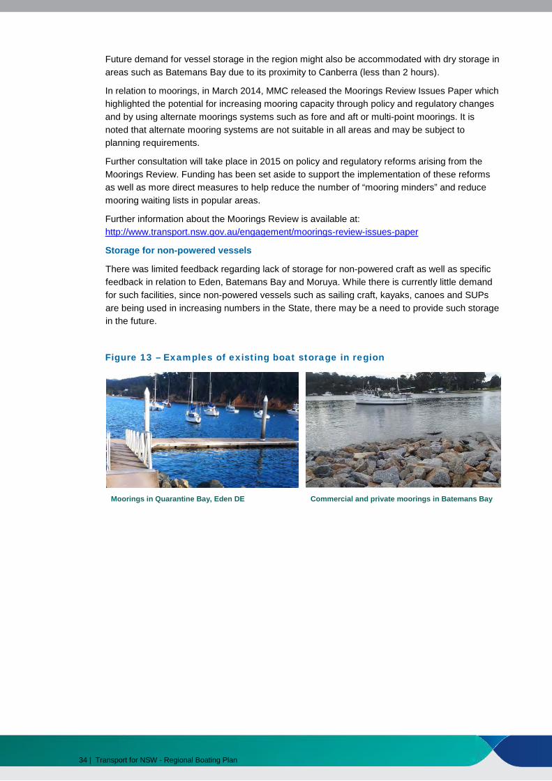
The largest concentrations of moorings in the region are at Batemans Bay (<155), Twofold Bay (<90) and Merimbula (<60). The remainder of mooring areas are no larger than 25 moorings and are usually distributed along the entrances and rivers. As demand for vessel storage in the region expands, vessel storage will be required. Providing additional on-water storage in Eden and Batemans Bay, in addition to the small harbours in the region will not only help to meet this demand, but will also bring economic benefits to the region.
Transport for NSW - Regional Boating Plan | 33
Future demand for vessel storage in the region might also be accommodated with dry storage in areas such as Batemans Bay due to its proximity to Canberra (less than 2 hours).
In relation to moorings, in March 2014, MMC released the Moorings Review Issues Paper which highlighted the potential for increasing mooring capacity through policy and regulatory changes and by using alternate moorings systems such as fore and aft or multi-point moorings. It is noted that alternate mooring systems are not suitable in all areas and may be subject to planning requirements.
Further consultation will take place in 2015 on policy and regulatory reforms arising from the Moorings Review. Funding has been set aside to support the implementation of these reforms as well as more direct measures to help reduce the number of “mooring minders” and reduce mooring waiting lists in popular areas.
Further information about the Moorings Review is available at: http://www.transport.nsw.gov.au/engagement/moorings-review-issues-paper
Storage for non-powered vessels
There was limited feedback regarding lack of storage for non-powered craft as well as specific feedback in relation to Eden, Batemans Bay and Moruya. While there is currently little demand for such facilities, since non-powered vessels such as sailing craft, kayaks, canoes and SUPs are being used in increasing numbers in the State, there may be a need to provide such storage in the future.
Figure 13 – Examples of existing boat storage in region
Moorings in Quarantine Bay, Eden DE Commercial and private moorings in Batemans Bay
34 | Transport for NSW - Regional Boating Plan

7. Feedback on Consultation Draft
7.1 Feedback Summary
Feedback from Councils, stakeholder groups and the public was generally supportive of the findings and broad actions proposed in the Draft Regional Boating Plan.
7.1.1 Safety
Feedback on the Consultation Draft supported the proposed safety actions, particularly the need to improve user behaviour. The importance of educating boaters, including those not familiar with the area and those travelling from interstate, about safe behaviour on the region’s waterways was highlighted as being a key priority.
Bar crossing safety and offshore boating was also highlighted as a key safety issue for the region. More education on the safest way to cross bars and greater enforcement of the correct safety equipment that must be on board vessels when going offshore was supported. The lack of courtesy moorings in the region was also mentioned as a safety issue for travelling vessels looking for a safe place to tie up, especially during bad weather.
Locally, issues such as additional speed limit zones and no wash zones were suggested in areas of high swimmer and non powered craft activity. Continuing support for the PWC focused Courtesy Rider program was also sought.
7.1.2 Access
Providing new and better boating access infrastructure in the region was strongly supported in community feedback on the Consultation Draft. Comments received on the potential projects, including Councils’ views on priority projects, have helped inform the list of projects identified in Chapter 8 which have been identified for priority funding as part of the NSW Boating Now program.
Other key issues raised in community feedback included the need for boat ramps which allowed for ocean access without crossing a bar and the lack of non powered craft launching areas. The need for better infrastructure to enable boaters to load and unload passengers at Batemans Bay and a pump out facility west of the bridge at Batemans Bay was also highlighted, as was the need for improved disability access in the region.
Feedback suggested courtesy moorings are required at Twofold Bay, Batemans Bay, Moruya and Narooma.
While outside of the scope of Boating Now funding, feedback supported dredging being carried out at a number of locations including Merimbula, Clyde River,
Transport for NSW - Regional Boating Plan | 35

Batemans Bay, Lower Moruya River, Wagonga Inlet and Turros. Since the Consultation Draft was released, the second phase of the Rescuing Our Waterways program allocated $250,000 to dredging works on the Clyde River estuary and $20,000 at the Tuross Lake entrance.
Further details on proposed access projects are detailed in Chapter 8.
7.1.3 Storage
The increasing need for on-water and land based boat storage was raised by Councils and other stakeholders in a number of areas in the region including Batemans Bay and Eden. The community supported proposed actions to increased storage in the region and these locations and requested support for the fast tracking of existing storage upgrades.
Kayaking stakeholders suggested that storage for non powered craft was not a priority for most users due to the variety of locations that were available in the region, a centralised storage facility would not provide the flexibility that most users enjoy.
36 | Transport for NSW - Regional Boating Plan

8. Delivery Program
8.1 Summary
Table 3 provides a summary of how the actions identified in the Regional Boating Plan will be delivered across the three categories of safety, access and storage. A progress report on the Delivery Program will be published annually.
8.2 NSW Boating Now Funding
$1.48m in NSW Boating Now funding has been allocated to support delivery of the 8 infrastructure projects identified in Table 2 as being a priority for delivery over the next three years.
The total Regional allocation is based on estimated projects costs and the proposed financial contributions from Council and other delivery partners for individual projects. The total Regional allocation may be subject to variation following further negotiations with delivery partners to confirm project scope, design, timeframes, funding contributions and the most efficient project delivery method.
The projects are included as part of NSW Boating Statement which includes a total funding commitment of over $33 million to support the delivery of Priority Regional Projects across NSW The NSW Boating Statement can be downloaded at www.transport.nsw.gov.au/mmc. It includes the full list of Priority Regional Projects for each Region and details on how the Priority Regional Projects were identified.
The NSW Boating Statement includes a summary of the categories of funding to be made available over the five years of the NSW Boating Now program, including at least $10 million to be made available in 2017/18 and 2018/19 to support the delivery of a second round of infrastructure projects. Other funding categories include:
• $10 million to support the delivery of Major Projects that provide benefits to boaters inmore than one region including:
– Measures to address concerns about the impact of boating on riverbanks
– Boat storage strategies and pilot projects
– Establishing slipway facilities in strategic locations
– Measures to reduce the number of “mooring minders”.
• $5 million to support the delivery of dedicated off-street boat trailer parking facilities
Transport for NSW - Regional Boating Plan | 37
• $5 million to be assist with emergency repairs to boating infrastructure, particularly afterflood or storm events.
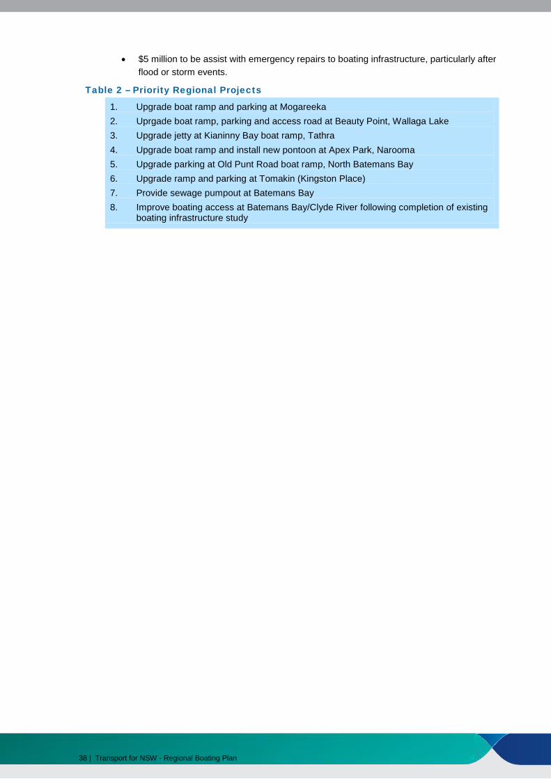
Table 2 – Priority Regional Projects
1. Upgrade boat ramp and parking at Mogareeka2. Uprgade boat ramp, parking and access road at Beauty Point, Wallaga Lake3. Upgrade jetty at Kianinny Bay boat ramp, Tathra4. Upgrade boat ramp and install new pontoon at Apex Park, Narooma5. Upgrade parking at Old Punt Road boat ramp, North Batemans Bay6. Upgrade ramp and parking at Tomakin (Kingston Place)7. Provide sewage pumpout at Batemans Bay8. Improve boating access at Batemans Bay/Clyde River following completion of existing
boating infrastructure study
38 | Transport for NSW - Regional Boating Plan

Roads and Maritime will review the current approach to addressing the user behaviour issues for the region including education and compliance campaigns within the region
Table 3 – Implementation of Boating Safety, Access and Storage Actions
Action Delivery
Safety Review strategies to improve on-water behaviour and safe boating practices across the region
Review the placement and planning of navigations aids and signage to improve navigation where appropriate
Roads and Maritime will review and upgrade as required existing signage and navigation aids across the region
Review strategies to improve safe vessel operation in open and offshore waters, when crossing ocean bars and when operating in isolated or remote waters
Roads and Maritime will work with MMC to review and update the current approach to education and compliance campaigns to raise awareness of boating safety issues associated with crossing ocean bars and operating in open and offshore waters and in isolated or remote waters. Roads and Maritime will explore opportunities to expand the existing network of bar crossing cameras and to improve communication of bar crossing conditions and ocean access ramps should be explored further.
Access Work with councils and other partners to improve the condition and capacity of existing boat ramps
$1.48 million in NSW Boating Now funds have been allocated to support the delivery of the 8 Priority Regional Projects listed in Table 2.
Roads and Maritime will investigate feasibility of installing courtesy moorings in the Far South Coast region such as Twofold Bay, Batemans Bay, Moruya, and Narooma.
Work with councils and other agencies to enhance access options such as jetties and pontoons at strategic locations and amenities such as sewage pump-outs
Continue support for the Rescuing Our Waterways dredging program
MMC and Roads and Maritime will continue to support the Rescuing Our Waterways dredging program and will work with Crown Lands on a longer term strategy for navigation dredging in NSW.
Since the Consultation Draft was released, Rescuing Our Waterways Round 2 funding has been allocated to dredging works on the Clyde River estuary ($250,000) and at the Tuross Lake entrance ($20,000).
Transport for NSW - Regional Boating Plan | 39
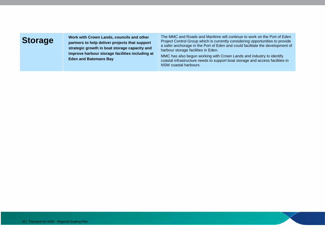
The MMC and Roads and Maritime will continue to work on the Port of Eden Work with Crown Lands, councils and other partners to help deliver projects that support strategic growth in boat storage capacity and improve harbour storage facilities including at
Project Control Group which is currently considering opportunities to provide a safer anchorage in the Port of Eden and could facilitate the development of harbour storage facilities in Eden.
Storage MMC has also begun working with Crown Lands and industry to identify
Eden and Batemans Bay coastal infrastructure needs to support boat storage and access facilities in NSW coastal harbours.
40 | Transport for NSW - Regional Boating Plan
Appendices

Appendix A – Maps

---------~------------ _\:::- -----------'"/
-------- !- - - -_- - - - -_- - t- - - - -_- - - - -_- -,'-------------
/_--------------- _------I- ------ea·------ ,_~_-_-_-_ -_-_-_-_-_-_ 'N - - rom-----
";\~ ~~1m~~~~~~~~~~~~:) <__-=================: ~/-._ _______ _ '· - - - - - -___ .,._··;;:: -::..--/
Oval
Calle Calle
0
\, I
Water Police &CustomsSnug
Cove
0
r·,
50 100 150 200 250 500" m PORT DETAIL INSET4
~.-<--------- _-::.-:,
N
~~7--- ~ n - - - - -__,
. (/ .•. ! i>t ~\ - - - - ·fA\- - ~ . ' '<'. .. ' ' :-:-:-:-:-& -:
------ w.__, ... ·::~--- .· tl.: !)1-E ------- ' I •'. -"'/"-------- \ • . \ I . / i
~~~ s
Worfing'· _ , \_\ :;-·<\ Point · ' ' MSwstona
Bay · Rock
__ j
EDEN
: I Cattle Ya~lumgo Bay Cove
··· I
Snug
' ,_ TASMAN 'r" --_,\ '
., 1, Ttie Eagles ·1'. Claw
I /
-- ---
-----
Rixons Bungo,Beach Beac~
, Oman / ' Poinr
Quondoa Point
Brandy Creak Beach
Currawulla Beach
I I
I I
Northcote ··· Point
- l
1 .
· I
I '
' <s> . 0 ', =<.
Bull Creek
: I
Cove
I_
Cocora lf'oint !
iI
tookout , Point
Twofold Bay
SEA
·--- ./
whale Seahorse
'·. 9!0 _ ........../ ... /./ Shoals \ l<.' ?
Nullica HoneysuckleBay Point
' '
__.. -' Jews / Head
, RedF' .· /• , 1 Point //I,--'
Woodchip ·Berth(
1 ,,r: Sqyds1/qwer i i _-.r•/
~~---' \ ..-C~·ocodile
,~ R~ck" I•
Multi PurposeBoydtown '''\ Berth'' .I'1 ,_ . (i ' East Boyd
Brierly Point Bay
.
FiSheries __, Beach
Kiah Inlet
Fisheries Flat
-- ____ J
Round Hill ------- t------ - -
---------~ ---- \_-___/.-"Myrtle ii
- -1, ''--' ·,- - - IWonboyn ---- ___-/ Disaster"Cove / @
u-- ---~- -- Lake ]Jay-~'- .,.-;/-",
1i ~· r\ Wonboyn (/.@ 0 -----------1 ,/- - - - - - - - - - -,'---------- I-----------' ----------/·---...__
·., Jawfish/ ,Bay ../ _ Beach~ ; Cliff
" 100 200 300 400 500
INSET 1
MAP OF
Twofold Bay and Wonboyn River Area 0 100 200 300 400 500
m
i-~1; TransportNSW Roads & Maritime GOVERNMENT Services
DISCLAIMER! This map is not intended to be used for navigational purposes and Roads and Mar~ime Services takes no responsibility for the accuracy of the content herein. Map Printed: August 2014. Copyright Roads and Maritime Services
1000
--------
-----
-----
-------------------
--
-- - ---
------
MAP OF
Tuross and Coila Lakes Area
~-----.-.J""~5m~oo;________..,:1ooo
~~k TransportNSW Roa~s & Maritime GOVERNMENT Serv1ces
DISCLAIMER! This map is not · t dpurposes and Roads and Marit:~en ad to be used for navigational accuracy of the content herein. e Services takes no responsibility for the
Map Pnnted: August 2014. Copyright Roads and Maritime Services
Coila
Coila
Turlinjah
Page Islets
Freds Island
Lake
Tuross 0Broadwater
~-
Brobo~~lfe Point
CdradgeBowns Point Bay
-~ i,' f!' /Deuaumba
! iii ! / ,'
____j lslanq..
Nouben \ ' --- foint
Reedy Island
·,Trunketabella Stdney BeachLake
/_[
Cooper ',.\ I .'•Island \I, \Tarandore /
Cambathin , ____..-, Tuross )Point / Island ------------ I IHead 0
P,lantation 1
!3aach ,
I I,
/ '
/ ' ,;:>
! . / _i j:r!:~// "/ . .. ;~ ·' . .. i<'')\
• . . @; -;)Tuross River -,_~- --- ' ruross
1Horse Island ... ®: : ;;~ : : · $an:..·,' '.. 0 ..Main .· Head
I i P. ·"' · -- -~ J3eacn • , 1 • • omt l ., .... Tuross ..... .... I. . . . ,. ·, . Beach
!iu.. :·,: ·. - : ~>~~--
///
ross : .: \·->-.- .. -... '').\ ~' ~\ \-,
• \ " \ o \
\ '--, • I I
' ' . ' . .-. ___, '•
:@ ·--- · ,._-,_ __ .- ~
- ---·
Borang Lake
Trunketabella Lake
River
---/
·---
m
1000
INSET 1 U.t~!jei'IOI'I!il~ liy~zotdei'I2BA.uglllll2014 b'f nilclllll'll
• ' ~- . . . ' . '' . • 1, · Lake: . ' I.
\· '
_)B/ackfellows Point
I '.
, Po\ato , Poiht Beach
Potato Point
!
Jemisons Beach
'
-------
----------------------
-----------
__ _
i----_-_
- ',
I - .~
0 100 200 300 400 500
m
Aughinish Rock
~
ala Jetty
- Bay/'
\ ' ·-Pebbly > Montague 8~~ 'i (i.Lv' - .
Island
INSET1
Lake
Mummuga
Evans Point
. \ I
Amherst Island
0
Dalmeny
I \
I
: I
' I
I
\ oo•a ' c:
\_ --\ ·- ... __
\~--------------- -- = Mummuga
- - -, _ ) Hrad / /_/
0
•___/ ,./ i
Dalmeny , Beach \
MAP DF
Wagonga Inlet, Mummuga Lake and Montague Island Area 0 100 200 300 400 500 1000
' I i
i-~k Transport
m
I INSW Roads & Maritime I ' I I
GOVERNMENT Services DISCLAIMER! This map is not intended to be used for navigational
' purposes and Roads and Maritime Services takes no responsibilijy for the accuracy of the content herein. Map Printed: August 2014. Copyright Roads and Maritime Services
I I
' ' Kiang a
' '
Lake
Kianga
I
C~rters B~ach
Kianga Point
I I N I ~
I
·~ '
-:.: /_ Mill iJ~ -
Barfows ~ · / • .Bay
L~---
• J ;
( · :. .:® . ---... --- ___: ) . . \, __; .,
Lewis'.- - - - - - - - - - Island---~- - - - - - !
) ------·-------
/------- /-------- Lavender
Point -~ - - - - - - - - -, ,_ - - - - - - - - -'
.!-:-:-:-:-:-:-:-:-:-:-I Clarks?'----------
/-- -..:;.--=------------------ Bay ·=-- -·- ,-------
L- ---------------
Black Bream Point
--~-- --- - - -
,'- - - - - - ------,_ - - - - - -· --------------
' • I
· \ . · I ... ' .
!@ .I . '
\. . /
--~--.:-·
/_ - - - - - - - - - - - - -
c -:<::: ~=~: ~=~~~~~~==: ~: ~: ~: ~: ~: ~: ~::-=--------- --~' -,---------------- ·Ringlarids ,
~---------..._.-_-_• - POint.
NAROOMA\:~:<co::: ~c-:::::: :1. _./ / / ,/ . ii • . Shell ' / .;;~; o·-,1: ~-=: :::::: ~>. \ R. . t /
, OIIJ • .. - ·__:::_, _/' ' I I===\====\=====~ --- ~\--- _\---- -\ Freshwater\ ' I
1 -=~ri~ . ~------~- . -.--I.\ I '· I IL--- ~--- -\-----\ Bay . /-<~/ "' "" ' ----\-_-~- Ring lands / -----~--\
; ;>·I Smugglers,
' . Cove II ' Bay :/·:_;./
/ /'·----->~------ -- -~~=~'=: ~== ~;~)- - - - - - -' .;. .-------·----=----.:-'··::.._---- ·"-,,.- -~ Rotary --~--_--:..-~----- ~--.::~-- //Paradise..... -,__ --- ~\~- ~-, ___ ..:___..._:_--~-: ---=..-- --"'-~---- 'fRinglands
\-':.,---- -\.- -'· Walking Track ' i -'·"--- 'el'.:--, 0Point\ ·._ - - -.... \ I ( ! I·-·-- -·--- _--. ~---·-.__ .;. . ' - --- - - -·- - ·· ..________
'' Ir_ -_-_ -_-_ -:-_ -___ .,____________ _ ____ /_ Forsters lz 1 c-~-~- Bay'- - - - - -::--"' ' ll> ' ;"------- \Q \ ---------------- ~"' -- ,(: ~: ~: ~:~ =~~~=~=~: ~=~~?~:;:;::::::::::: ~: ~: ~: )®> 'o .3 '.--~ - -Hcmeymoon
i ll> I-- ~ -=- =- =- =- =::-_- =- =- =- =- =- =- =-=- =- =-= ·<_- =- =- =- =- =- =- =- =- =- =- =- =- =- '=- =- ='" = - =..J '-- ~- ~-::- P()int__ Foot-/" Bridges '
' I' ' ' i I
Flying'~-·--~ FoxBay \
NaroomaLittle CemeteryLake
Cemetery Park
I s
Dooga
' I I
I I
I I '
Mullenderee
_';'I Sandy\[, ', ,\ Point River ; Garlandtown/
-~ !'>~-
Gundary
fi ___ _ '- ---
1 Shelly ,!'leach
'Ccc'c~,-,~-\
- 0'"· '-'1._"_-:;_--:o-_,. - -
...<::;;,~~~~-[ :2~,>-
MORUYA
Quandolo Island
,-:-'--~__ /'Racecourse 0
Gilmores Moruya:Creek Heads/Mynora
,_/, \
Creek
'
~--
\- - - -;
- - ' \:-:-1
"-, -~~~--" $;:"
~-------- - '
' --
' Congo \--'-
0
0 75 150 225 300 375
m
750
I I I
INSET/1
MAP OF
Moruya River and Congo Creek Area 0 100 200 300 400 500 1000
m
lt-~k TransportRoads & MaritimeNSW ·
GOVERNMENT 5erv1ces DISCLAIMER! This map is not intended to be used for navigational purposes and Roads and Maritima Services takes no rasponsibil~y for the accuracy of the content herein. Map Printed: August 2014. Copyright Roads and Maritime Services

--------------
N f (J)
, ;::~.
I ' .. ·-~·.~......•. '-... •·.·..········....w ti'·.· ··..·" ~ ' 15
Back·-.'- \ . /./
' -~--- \ _/ , } Lagoon \ -o\ g, \a
Merimbula
Lake
MAP DF
Merimbula and Pambula Lakes, Bega River and Tathra Area 0 75 150 225 300 375 750
m
~"k TransportNSW Roads & Maritime GOVERNMENT Services
DISCLAIMER! This map is not intended to be used for navigational purposes and Roads and Maritime Services takes no responsibil~y for the accuracy of the content herein. Map Printed: August 2014. Copyright Roads and Maritime Services
0 Shon ... Poin(, · ··
/i.
Merimbula ,-.___i
0 . 10\ . . \21 . .~-· ,---·
f' ... ' '
' ' f
I i.s::: I / {) I i CU'. a> I I a!
I
0 .. ,.
:® : . ~
. ' TASMAN :@
0 :®
Merimbu/a Point
Roc;:k
SEA
. '
Merimbula
Tath;ii , /~' /:lead
/<'_._. ,I
It
0
Tathra
I
(
--, I0 ··~ Kianinny Bay /
0 100 200 300 400 500 1ooo INSET2
m
Mogareeka . ' '
. . / i .
. \1/ -:·.·;
~<--)--:-~ ,:;:_
.;:::_-;
..
I .
0
·~ .. \ '
I / //.' L' . .
., 1
' I:®: ,.
.Mogareeka Inlet
0
; . :· I •
i .
• /
INSET3
Bay
'· '. \
Hunter?, ·.... Rock -·"~--\j-;___·,,..,
/ ' \
' . \ ~ ------.
\::\.:\\',_ l__ '"
Pambula Beach
0
· Haystack Rock
Yowqka / ----- ) \
Tee ·.. Tree • )Point1
. Long '.,POifJL _il
---' I \_/
)
Pambula Lake
Yellow o,.,-,;1;;:_;;2';lD£..""'l3r:_:;o,;•oo~-.050~oiooo.,..,..,.;;;;imii,'oo Point INSET 1
m
River
Black Ada
Swamp
Humbug Reach
0 100 200 '· 300 400 500 1000
m

-------------------------------------------------
- - - -
-- - - - - - -
----------------------------------
- - - - - - - - - - - - - - - - - - - - - - - - - - - - - - - - - - - - - - - - - - - - - - - - - - - - - - - - - - - - -- - - - - - - - - - - - - - - - - - - ---------------------------------------- ------ - - - -
- - - - - - - -
MAP OF
Wallaga and Corunna Lakes, Bermagui and Brogo Dam Area 0 100 200 300 400 500 1000
~~k TransportNSW Roads & Maritime GOVERNMENT Services
DISCLAIMER! This map is not intended to be used for navigational purposes and Roads and Maritime Services takes no responsibility for the accuracy of the content herein. Map Printed: August 2014. Copyright Roads and Maritime Services
-1
SnakE!! Island
NargafLake ·
i
Corunna
Lake
Corunna ~j\, Poin.L .-i 1
[) 1[)[) 20[) 30[) 40[) 50[) 1000
INSET2 m
, I
-- _. _.
:(
-.-~-.
Nelsons Creek
/· Jackpot
0 0.25 0.5 [).75 1.25 2.5
km
•, - - - -~__-:.::--- -- ~- - - -~~
- - - - - - - - - - - ~
- - - _-_ - - - - - _-_ - - - ~ . - - - - - - - - - - - - - - - -· -----------------· - -_- - - - -- -- -_- - - - -_- - "'-,
-------------------------------------- ·, ::::::::::::: :@:::::::::::::::::::::::\
- - - - - - - - - - - - - - - - - - - - - ', . - - - - - - - - - - - - - - - - - - - - - -\
-----------------------1- - - - - - - - - - - - - - - - - - - - - -\----------------------· ---------------------- -\ _-_-_-_-_-_-_-_-_-_-_-_-_-_-_-_-_-_-_-_-_-_-_~
----------------------' - - - - - - - - - - - - - - - - - - - - - _\----------------------1 -----------------------~ _-_-_-_-_-_-_-_-_-_-_-_-_-_-_-_-_-_-_-_-_-_-~
:::::::::::::::::::::::::::::::::::::::: : t~=:: :': - - - - - - - - - - - - - - - - - - - - -t'i:> - •-- -- -- -- -- -- -- -- -- -- -- -- -- -- -- ---- -------'i -
-: ~ ~ ~ ~ ~ ~ ~ ~ ~ ~ ~ ~ ~ ~ ~ ~ ~ ~ ~ ~ ~ ~ ~ ~ ~ ~ ~ ~ ~ ~ ~ ~ ~ ~ ~ ~ ~ ~ ~ ~ ~ ~ ~ ~ i~ ~ :\j
_-_-_-_-_-_-_-_-_-_-_-_-_-_-_-_-_-_-_-_-_-_-_-_~ _
-_-_-_-_-_-_-_-_-_-_-_-_-_-_-_-_-_-_-_-_-_-_-_-_ ;ec~
N
w
s
Couria Bay
Anelele
Kings CemeteryCorner Point
Snapper Point Point
/ HawkesWallaga ; .
Nest
\ Honeysuckle , Island
GreenBay _/ Merriman'vum Island'/Point
.f,ong Bay
Regatta PointLake ·
Murunna Point
Wallaga Lake /7Heights /I
·- Pebbly · Beach
II .
{ i
Beauty ViewingPoint Platform
·----.__
Wallaga Lake I Park
---~
I Fairhaven Fishermans
Ba)'Meads Bay
INSET 3
Bermagui
\ I""'------
.-:;.'" ~------------ /- - - - - - - - - --:-_-_-_-_-_-_-_-_i-, ----------,_ - - - - - - - - - - - ·-::.-.,/'---------~--------------------- ~ - - - - - - - - - - - - - -~ . - - - - - - - - - - _, -"--------------
~------------> --------------------------------- ·---../'- - - - - - - - - - - - _, ._ _________________ ::._
-::_'------------------------- j
' -------------------------- (-: -: -: -: -: -: -: -: -: -: -: -: -: -: ':-: -: -: -:-: -: -: -: -: -: -: -: -: -: -: -: -:-: -: -:'' --
----:::·!/ I\~/I - - - - - - - - - - - - - - - - - - - - - - - - - - - - - - - - - - - - -\ \- - - - - - - - - - - - - - - - - - - - - - - - - - - - - - - - - - - - - ._- _- _- _- _- _- _- _- _- _- _- _- _-_- _-_- _-_- _-_- _-_- _- _- ' -:. - -_- _-_- _-_- _-_- _-_- _- _- _- _- _- _- _- _- _- _- _- _- _- _- _-_- _- _-_- _-_- _-_- _-_
------ / r------------------------------------------------ 1,-- \ ,.. -------------------------------------------------------------------- Point / li\ Cowrie,-j// /[ ii Dickinson '--::::::::::::::::::::::::::::::::::::::::::::::::-- ·=:::, \::::::::::::::::®:::::::::::::::::::::::::::::::::::::::::::::::::::::::. Horseshoe BeacJ'f t'J ·---- -'1
-:-:-:-:-:-:-:-:-:-:-:-:-:-:-:-:-:-:-:-:-:-:-:-:-:-:-:---- ',::::: :::::::::::::::::::::::::::::::::::::::::::::::::::::::::::::::::::::::=-=: ' /)_ -- Bay i ,--: " __ / ii \
i' / .' / ,, ~- _/- ==:: ~: ~: ~: ~: ~: ~: ~: ~: ~: ~: ~: ~: ~: ~: ~: ~: ~: ~: ~: ~: ~: ~: ~: ~: ~::::: =____i: ~: ~: ~ == _=-- =·= ~: ~: ~: ~: ~: ~: ~: ~: ~: ~: ~: ~: ~: ~: ~: ~: ~: ~: ~: ~: ~: ~8#~~ ~: ~: ~: ~ ~ ~~ ~: ~: ~: ~: ~: ?~s::::d~: ~: ~::
-------------------------------------------- - -_-------- -_------ -_/-- ----~---- -_-- -··-.,--- -_----------------------------------------------- - --- - - - - - - - --- - - - - - -- - _,.- -- \- -_-_-_-_-_-_-_-_-_-_-_-_-_-_-_-_-_-_-_-_-_-_-_-_-_-_-_-_-_-_-_-_-_-_-_-_-_-_-_-_-_-_-_-_-_-_-_-_-_-_-_-_-_-_-_-_-_~~~- - -
" shelly ~--------_,- - - - - - - - - ,Beach'--------- -/ - - - - - - - -
-~-------------------I---
-,--- Berll1Jll!ur ----- -·,- e ---. f3each0 ---------------
'" " ~ B.. ·~\ . - ~ ==========================--c.- -- ="'> ~-~-'_ -
- ·---- - - - - - - - -/
- - -~~-~--:..--
Bermagui South
0 25 50 75 100 125 250
ll'IS-ET 1-··-.
--
1000
---
BATEMANS BAY
Shallow Crossing
'I I I
'I I' II II
'I I . 0 0.25 0.5 0.75 ' 1.25 2.5
1 km INSET2
Nelligen
I
-----.. ··---
I '1\ Big
.- -
.-. ·---
,Island 1
I I
Ryans Island
River
Runnyford
Mays Wharf
U.t~!jei"IOI'I!il~liy~zotdCI'I2BA.ug14byrnhoiiM1
River
creek
Snapper Point '"''0.,,,.,&,-,"'''"'"'J
"'· \:, :~oat
. Snapper ·-, ;; Island
' 1[ )\
\\\
\.;\ -<· < " ~ XJqservation Catalina : 1i_eadHeights
I '
N
s
MAP OF
Clyde River and Batemans Bay Area 0 100 200 300 400 500-----m
;l~k TransportNSW Roa~s & Maritime GOVERNMENT Serv1ces
DISCLAIMER! This map is not intended to be used for navigational purposes and Roads and Marijime Services takes no responsibility for the accuracy of the content herein. Map Printed: August2014. Copyright Roads and Maritime Services
Nelligen
INSET 1
Cullendulla
-- - ---- -.----
0 100 200 300 400
\\.··., \\ ~
\\ '- ...
·-- / ----~··,
\ \
~~~rbour - - ~--
- - :::."'- - :..::-:,
Little Island /
0 100 200 300 <100 500 1000
m
,, \ )
I ( \
I
I j/
I ;l(u
Murramarang
/
\
Durras
INSET 1
0 76 160 226 300 376 750
m
Tomakin
SEA
INSET2
MAP OF Circuit Beach _Batemans Bay Coastal Detail and
_../-Tomaga River and Durras Lake area 0 0.25 0.5 0.75 1.25 2.5
km
Depotlt\~k Transport Durras BeachNorthNSW Roads & Maritime Black GOVERNMENT Services Rock
DISCLAIMER! This map is not intended to be used for navigational ·GrassiJoPper purposes and Roads and Maritime Services takes no responsibility for the Island accuracy of the content herein. Map Printed: August 2014. Copyright Roads and Maritime Services
Lilli . .· PiIIi f,~;r,r </
, Upl"ight
~--I
I. MOsquito (:rJ - -Btn'/ . .- \. ' --- - - "":'-.!( \
~\\ l1\
I' I\ Durras_./; Lake
Garden Bay
\ (
"', \ Durras
. . Malua --1
\ /~ !Wasp
Bay · ISI!fnd /-~:--'
I
Wobbegimg Bay! I "-<>.·..'- - -;:::_~0 -~-::='.JMalua
Bay I
1000
INSET3 Myrtle Beach
\'_y;.,-,<<>:..-\ Flat Rock
I ( ( :~~.~~;;
l.sland
Ril::hmond Beaon
--_,--",
)/
j / i/
'~ -- (,C'-1
'r, _ ,' · Maloneys ,,--"'- Beach
'•,_\ r,:-,-,
\ -.-,I •I) I' -- .( ·.'.:/ I(_
:_ ,Jl-:-~// /f) I
.r~iie~ • Point
snapper .Island I
'·
------ AcherbnBatemails Ledg~
Bay
"6>~ /bbseM!tionCatalina 1>::.:.-- ( Head-.Heights " '·\...
li'r I
\.\, \Caseys \\ Be~__,-
Batehaven
Sunshine Bay ..Jollgate
lslands
Den hams Beach
·
l Black Rock
Lilli Pilli
Malua Bay I
\ .. _
I ,__:_-- ..
Rosedale ---. ··-,' :~>
Mossy Point
Tomakin
.;~ : ~oseckle , ·, Clieach \ "\ \ . \
\:;_ ' <--'
- . •I
C~(•1_1 ',
Candlagan
Guerilla Bay
___/
-.._ ~~\
I - ---- ----.
I
Bm~lee Beaph
Broulee
,_)
·, '. ',_ / -~------
J
BATEMANS BAY
i /
.. - --~,s,.,
0 100 200 300 400'
Surfside
- ___I
1\
I
r----.__/rrennant
Rock
(
North Head Beaoh
-. Three \ Islet ) Reef
\, - ~~\
'( ~-;.->/
r--~--='-- .?-'' 'f,- Hon~~~ckl~
,:1Be&.l::tJ '
,._.•/
)( i
0 ]! : -:}!
)I \ )) / '
, <,.,;;: · / North Head
i7: -<;!_i
------------
--------
Snapper Point
(
~~;~~1~;~ ~=·\?/
<
Chinamans , Point 1
Oyster - - ---- Lease
·iif<S
\~~ ) "£j,
' -'l '"•"
/,1Pt\~~~, :,~1,~,t-_. ~t!!!'"~''-%-Kl~fr;1 • , ~-~~~'~tit:f~,~~~l:",~& ' :d ~,,.,,~;'f,,;.,;;,p ~'-"'" ""'''"'' : ;.·;!:: i'%·J
·:s ''''" :;,_,, .'J·:~,-v,,;,,~·'\"<"•~'4"•,; ' '"''"!;~~~~:;~~~~'1C"j 3~~\\;"~~- ,;o?f ,• <1~1¢ ;<'J¥-b:~,; ?f~;~:';-c·i< ' Xi'- .. "'f·.'.•.·.('~.htr. S:.::c.i"'""•··~ -~ .. ~x~:-?'"'~,...,_.. _· __ ~_,o;,::r~,>-h-'" "' -· . ,->v.~s,vvi,;v'~,:;:;-~,%·•,"' .,::;1 :\ J•;'ii:":;;;?~';''l:';~:J,,,~ ' '·'•'d•''''""'" >·y ~ ,,, ••q•.•c,>(•e;v'')'],?'-l>,,f)'.c',l' ;~c,•;HI c. ''''£;'",""~~-~~"'-··"'. )~~ '"• ,.'"''"_,: '·""'-'.,,IX?;,.,' •'\- ' > ' ? " ''''"' ' "" ')q, , ·'"' ,) .;, •'' ,,.,,.'l4v>·'l•ill ' ' c,;- ,,_, ·" " " .!- ' ,--',"";'•··';' ., ,. ' '> '•' ' .-,,, C); t \1i>C) '' m ,,,,%i.>!"'S<I<;>t<i;-.l,i.c -:-:: "" • w"'\ '~'r.-~ ""it%~'"';r,:;;;:' ''X-''"" ,,, , .-; ;,,,?\•'• C,;,•,' ;;,,.: ', :· ';'-'
'i ' ,... "-'''·"' _-t '"""'''"''''""i,iJ'<'?\'•; \r;;~;j'A~:w ·''·""':;;';!\" '0;.·- ",.:. ~, , v_ce:<,-·"'.·.:..-;;:--"':;,'>.'", ~ "~- ~ ,_ ,_': 1":.' 1>i:~M;,i'"'<r~:../'-'/
,-- '.f""0_ "''f'Ci , ~:_,;r ::" -~"'·r"h ' Jb \-\ ,.,~ ,.),. "' \ %-";~- ~-- ' j ~~ 1- '.f"iR:'• 9-f<"~, ~*r 1 :_-·r :;:fh~i,i;;J ,;?';:'' ~~· ?"·: ?;,t:~:;·<> '
\>:~;~(-'-?/ r ~ 'S!:r~~,,~~';'·J7~/:l " ki ·5<~ :;-· ( y~ ,rt /;." ""'" ;?' ~-) ,-~ }
' ' 'k,. ~~'- 'i ·. "-1" ~ ~-,t. </ ,~,
{'i7it:-i;:
[~j:/'
~ - --
North4>;.. Batemans··· ..... __ ver SurfsideBay
~ \
\
Hawks Nest
Headland
@
\,Wrayi
I 11<:Y / Smoke Point ' ',,',./,
Budd Island
-\ ' - -
\--- '. ~' - ~---·"", . \¥ [ mC'
\-:. <,-_-_- -~ 0 I• \J;,t --- =- =-- =-\- _-_-,
,.=-==-=-=~-..
Pinnacle Point
'-- /
_/;
-·r
Square Head
BATEMANS ..-,BAY
--.®-'·-::-____ --===-= :::::-\ *'10-----' ~
"- -,'-
r;:·:~-: :=:-:-:-:::::::- Batema11s
Bay
Snapper/Island I.
(_)
ObseNation Head
Batehaven 0 75 150 225 300 375 750
INSET 1 m