transims training course at tracc
TRANSCRIPT
TRANSIMS Training Course at TRACCTransportation Research and Analysis Computing Cent er
Part 8
TRANSIMS Configurationand Framework
Dr.-Ing. Hubert Ley
Transportation Research and Analysis Computing Center
Last Updated: April 21, 2008

2TRANSIMS Training Course at TRACC
Contents
� TRANSIMS Configuration and Framework� Distribution of TRANSIMS� Advanced Windows Installations with Source Code� Advanced Linux/Unix Installations with Source Code� TRANSIMS Executable Options� Command Line Options and Invocation� TRANSIMS Tools - Conversion of Road Networks� TRANSIMS Tools – GIS Layer Output� TRANSIMS Tools – GIS Network Editing� TRANSIMS Tools – Trip Conversion� TRANSIMS Tools - Partitioning� TRANSIMS Tools – Subarea Microsimulation� TRANSIMS Tools – Feedback and Evaluation of Solutions� TRANSIMS Tools – Other Utilities� Scripting unde Windows and Linux� The TRACC HPC Cluster
3TRANSIMS Training Course at TRACC
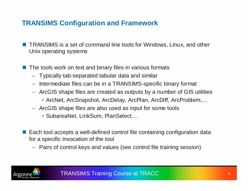
TRANSIMS Configuration and Framework
� TRANSIMS is a set of command line tools for Windows, Linux, and other Unix operating systems
� The tools work on text and binary files in various formats– Typically tab-separated tabular data and similar– Intermediate files can be in a TRANSIMS-specific binary format– ArcGIS shape files are created as outputs by a number of GIS utilities
• ArcNet, ArcSnapshot, ArcDelay, ArcPlan, ArcDiff, ArcProblem,…– ArcGIS shape files are also used as input for some tools
• SubareaNet, LinkSum, PlanSelect…
� Each tool accepts a well-defined control file containing configuration data for a specific invocation of the tool– Pairs of control keys and values (see control file training session)

4TRANSIMS Training Course at TRACC
Distribution of TRANSIMS
� Windows– Downloadable ZIP file of recently released 32bit executables– Executables should be placed into a suitable directory and added to
the system path– Optionally, the DOS path can be set to include this directory
� Linux– Downloadable “TarBall” containing everything needed for compilation
and installation• Compatible with GCC-enabled Linux and Unix platforms• Can be repackaged into RPM packages using “rpmbuild”• Can be compiled under Linux using configure and make
� Execution Framework– User-supplied shell scripts and batch files are typically used to
invoke a sequence of TRANSIMS tools in a well-defined order

5TRANSIMS Training Course at TRACC
Advanced Windows Installations withSource Code
� Install the TortoiseSVN interactive SVN client package– Can be found on and downloaded from SourceForge
� Install Visual Studio 2005 Professional (or Express – for free)– This may download up to 1GB of installation files from Microsoft
� Create a directory “Transims40” for the working directory to contain the latest source files on your hard drive in an appropriate location
� Right-click the directory and choose“TortoiseSVN Checkout”
� The URL of the repository is– https://transims.sv n.sourceforge.net/sv nroot/transims/version4/trunk/src/Transims40
� Click OK to download the latest source code� Enter the directory and double-click on
“Transim40.sln”� Build the entire solution or individual executables
6TRANSIMS Training Course at TRACC
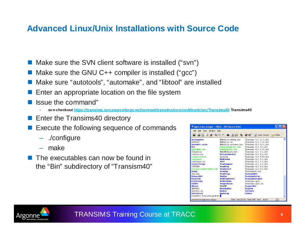
Advanced Linux/Unix Installations with Source Code
� Make sure the SVN client software is installed (“svn”)� Make sure the GNU C++ compiler is installed (“gcc”)� Make sure “autotools”, “automake”, and “libtool” are installed� Enter an appropriate location on the file system� Issue the command”
– sv n checkout https://transims.svn.sourceforge.net/svnroot/transims/version4/trunk/src/Transims40 Transims40
� Enter the Transims40 directory� Execute the following sequence of commands
– ./configure– make
� The executables can now be found inthe “Bin” subdirectory of “Transism40”
7TRANSIMS Training Course at TRACC
TRANSIMS Executable Options
� All of the TRANSIMS executables accept the following command line options– -H will display some help, including a list of all control keys
available for the particular executable (very helpful in the absence of documentation for some of the tools).
– -K will check all keys read from the control file and treat the ones that do not apply to the current tool as warnings, displaying a message on the screen and in the log file.
– -B will operate the tool in BATCH mode, disallowing any interactive keyboard input. Progress messages are written line by line instead of backspacing and rewriting.
– -Q will suppress much of the screen output and display only essential errors or exit conditions.
� Common return codes from the executables:– 0: SUCCESS– 1: ERROR– 2: WARNING

8TRANSIMS Training Course at TRACC
TRANSIMS Framework
� The user typically creates batch files or scripts to invoke the executables on a series of files, containing for example– C:\Transims40\Bin\TransimsNet –K –B TransimsNet.ctl– C:\Transims40\Bin\IntControl –K –B IntControl.ctl– C:\Transims40\Bin\ArcNet –K –B ArcNet.ctl
� Control files contain key and value pairs such as– NET_DIRECTORY ../../network/production– NET_NODE_TABLE FullArea_Node– NET_LINK_TABLE FullArea_Link– NET_ACTIVITY_LOCATION_TABLE FullArea_Activity_Location– NET_PARKING_TABLE FullArea_Parking
� Execution creates log files with the extension “.prn” in the same directory where the control files are located, containing detailed log information about the execution of the tool
9TRANSIMS Training Course at TRACC
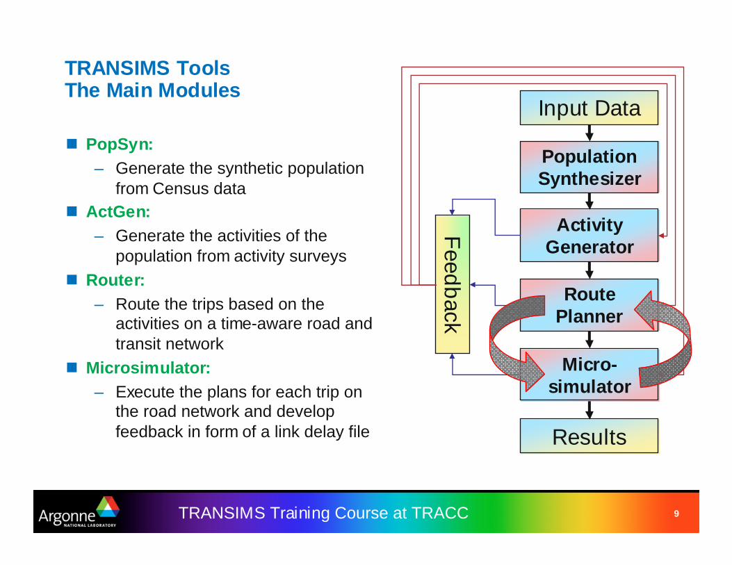
TRANSIMS ToolsThe Main Modules
� PopSyn:– Generate the synthetic population
from Census data� ActGen:
– Generate the activities of the population from activity surveys
� Router:– Route the trips based on the
activities on a time-aware road and transit network
� Microsimulator:– Execute the plans for each trip on
the road network and develop feedback in form of a link delay file
Input Data
PopulationSynthesizer
ActivityGenerator
RoutePlanner
Micro-simulator
Results
Feed
back

10TRANSIMS Training Course at TRACC
TRANSIMS ToolsConversion of Road Networks
11TRANSIMS Training Course at TRACC
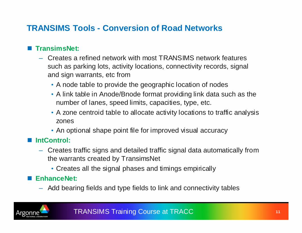
TRANSIMS Tools - Conversion of Road Networks
� TransimsNet:– Creates a refined network with most TRANSIMS network features
such as parking lots, activity locations, connectivity records, signal and sign warrants, etc from• A node table to provide the geographic location of nodes• A link table in Anode/Bnode format providing link data such as the
number of lanes, speed limits, capacities, type, etc.• A zone centroid table to allocate activity locations to traffic analysis
zones• An optional shape point file for improved visual accuracy
� IntControl:– Creates traffic signs and detailed traffic signal data automatically from
the warrants created by TransimsNet• Creates all the signal phases and timings empirically
� EnhanceNet:– Add bearing fields and type fields to link and connectivity tables

12TRANSIMS Training Course at TRACC
TRANSIMS Tools - Conversion of Road Networks
Sample input tables for:� Nodes� Links� Zones� Shapes
(not shown)
NODE X_COORD Y_COORD
1945 428121 4748132
1946 424938 4753691.5
1947 412534 4746420
…
5001 327590.3 4581616.5
5002 327595.4 4581687.5
ANODE BNODE LENGTH LANES_AB LANES_BA SPEED_AB SPEED_BA CAP_AB CAP_BA …
1945 19688 4409.60 3 3 24.58 24.58 2430.0 5400.0 …
1946 11223 1367.94 3 0 29.05 0.0 6000.0 0.0 …
1947 8666 6099.41 2 2 24.58 24.58 4000.0 4000.0 …
TYPE USE TOLL_AB TOLL_BA STREET
ZONECONN AUTO/TRUCK/WALK 0.0 0.0 I-90
ZONECONN AUTO/TRUCK 0.0 0.0 I-88
ZONECONN AUTO/TRUCK/BUS 0.0 0.0 I-55
ZONE X_COORD Y_COORD AREATYPE
1 446306.5 4638415 1
2 446724.4 4638426 1
3 447302.5 4638440 2
4 447672.9 4638431 2
5 448209.2 4638283 2

13TRANSIMS Training Course at TRACC
TRANSIMS Tools – GIS Layer Output
� ArcNet:– Creates highly detailed GIS shape files for links, nodes, and most
other network features for visualization in ArcGIS (see previous slide)– Many configuration options to show individual lanes, activity locations,
parking lots, and much more� ArcPlan:
Show individual plans or groups of plans in form of lines on the road and transit network (after routing)
� ArcProblem:– Visualize the location of different problem
types, such as:• Zero Node Problem• Access Problem• Circuity Problem, etc.
– Works both for router and microsimulator
14TRANSIMS Training Course at TRACC
TRANSIMS ToolsGIS Layer Output
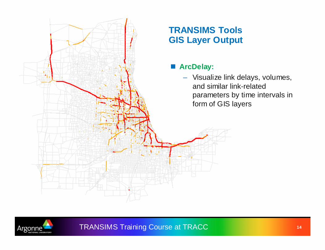
� ArcDelay:– Visualize link delays, volumes,
and similar link-related parameters by time intervals in form of GIS layers

15TRANSIMS Training Course at TRACC
TRANSIMS Tools – GIS Network Editing
� GISNet:– Reads ArcGIS node and link shape files and converts them into
standard TRANSIMS network files– The node file is used
to adjust the locationof the nodes
– The link file is used tointroduce or editshape points
Network Editing� Move nodes� Create shape points on links
� GISNet extracts geocodinginto attributes
16TRANSIMS Training Course at TRACC
TRANSIMS Tools – Trip Conversion
� ConvertTrips:– Read trip tables and diurnal distributions and extrapolate to individual
trips from activity location to activity location– Create artificial vehicles, households, and travelers– Assign vehicle types to trip table types– Estimate trip duration– Create a record for each trip in the trip table– Vehicular traffic as well as transit trips, park & ride, etc.
� DiurnalMatrix:– Specialized program to deal with thousands of diurnal distributions if
they are known for each zone– The tools creates all necessary input files for ConvertTrips including
TRANSIMS script files
17TRANSIMS Training Course at TRACC
TRANSIMS Tools - Partitioning
� HHList:– Extract a randomized list of households from a larger household list
into a set of household lists to be used for partitioning– Each of these files contains approximately the same number of
households� Partitioning starts with the Router:
– The router can use these household lists to work on a partial set of households. While reading the trip list, all records not belonging to the given household list are skipped so that the plan file contains only plans for the households in that list.
– When partition-aware tools are invoked in partitioning mode, the number of the partition is passed on the command line as the last argument, e.g.
• Router –K –B Router.ctl 0– Partitioned data files have extensions “.tAA”, “.tAB”, etc.– Other tools that read and process plan files work simply on the subset
defined by the partition number
18TRANSIMS Training Course at TRACC
TRANSIMS Tools – Subarea Microsimulation
� SubareaNet:– This is a tool that uses a GIS shape file to cut out a part of the larger
network and rewrite it as a new network with boundary parking on all links that were cut through.
� SubareaPlans:– This is the corresponding tool that analyses the plans for each trip
and determines whether they touch the subarea network at any time during the day
– Trips that go through the subarea are extracted into a new plan file and are augmented with start and end parking locations corresponding to the router’s time at which the trip enters and leaves the subarea network
� LinkDelay:– Merge link delays for the entire network and the subarea network
after microsimulation
19TRANSIMS Training Course at TRACC
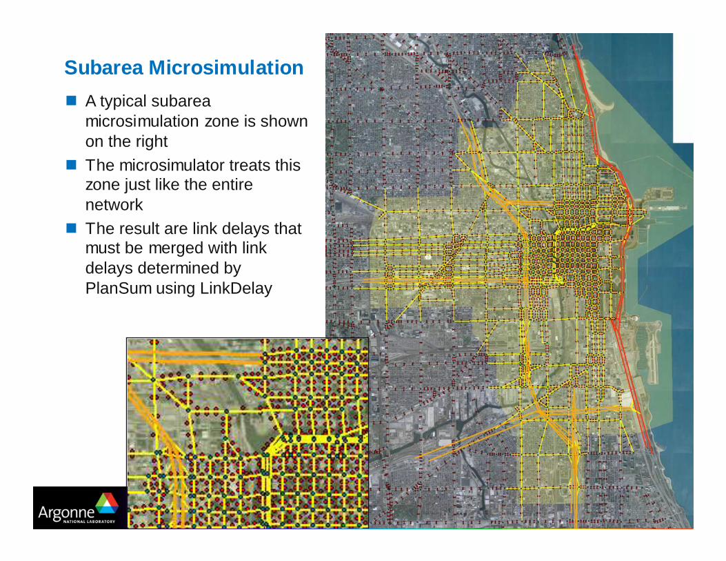
Subarea Microsimulation
� A typical subarea microsimulation zone is shown on the right
� The microsimulator treats this zone just like the entire network
� The result are link delays that must be merged with link delays determined by PlanSum using LinkDelay

20TRANSIMS Training Course at TRACC
TRANSIMS Tools – Feedback and Evaluation of Solution s
� PlanSelect:– Select households for rerouting based on criteria such as
• time of day, plan duration, V/C ratios• coordinates, vehicle types, subarea polygons, nodes
� ProblemSelect:– Select households for rerouting based on criteria such as
• time of day, problem link, problem type
� PlanCompare:– Generate convergence statistics and distribution charts by time of day– Compare plans files and select plans that have significantly different
travel times

21TRANSIMS Training Course at TRACC
TRANSIMS Tools – Other Utilities
� LinkSum:– Generate link data files of volumes, speeds, travel times, V/C ratios, travel
time ratios, delay, average density, maximum density, average queue, maximum queue, and cycle failures summarized by time of day
– Summarize data within a subarea polygon or for specified facility types– Summarize link data by zone or zone group found in the activity location
file– Summarize activity location data fields by link direction– Report the links with the top 100 link volumes, lane volumes, period
volumes, speed reductions, V/C ratios, travel time ratios, volume changes, or travel time changes
– Report the link groups with total volumes greater than user specified values
– Report the distribution of travel time, V/C ratio, travel time change, and volume change by lane kilometer and time period; and
– Report various network performance statistics

22TRANSIMS Training Course at TRACC
TRANSIMS Tools – Other Utilities
� ArcSnapshot:– Create GIS shape files from selected records in the TRANSIMS
microsimulator snapshot files
� LinkDelay:– Merge, average, and convert link delay files or smooth the link delays
between time increments (see also: subarea microsimulation)
� NewFormat:– Converts Version 3 transit driver plans to a Version 4 transit driver file– Converts a Version 3 population file to a Version 4 household and
population file– Converts a Version 3 activity file to a Version 4 activity file– Converts a Version 3 survey activity file to a Version 4 survey activity file

23TRANSIMS Training Course at TRACC
TRANSIMS Tools – Other Utilities
� PlanPrep:– Merge, sort, select, and combine plan files– Reintegrate subarea plans with regional plan files– Create and check plan partitions– Generate distribution reports of path and travel time changes
� PlanSum:– Summarize the link demands generated by the Router– Apply volume-delay equations to estimate link travel times– Produce link volume, link delay, and turning movement files by time of day– Produce zone or district trip tables and skim files by mode and time of day– Summarize transit ridership demand by transit route, run, and stop– Generate V/C ratio reports by link and link groups by time of day– Create diurnal distributions of the start, end, and mid-trip times of each plan
24TRANSIMS Training Course at TRACC
TRANSIMS Tools – Other Utilities
� PlanTrips:– Generate a trip file from a plan file– Use the time constraints from the original trip file and the trip duration
from the plan file– To update the trip start and end times in the new trip file and optionally
the new plan file– Generate a report documenting the plan time shifts in 5 minute
increments
� Validate:– Compare link delay file to link and/or turning movement counts– Compare link volume and/or movement files to link and turning
movement counts– Generate statistical reports for volume level, facility type, area types,
link group (screenline), zone group (district), and turning movements– Output link volume data by time increment and time period ranges

25TRANSIMS Training Course at TRACC
TRANSIMS Tools – Other Utilities
� VehGen:– Synthesize and locate vehicles based on the number of vehicles in
each household
� To be continued …

26TRANSIMS Training Course at TRACC
TRANSIMS Tools – Currently Undocumented Tools
�AdjustPlans�ArcDiff�ArcRider�CoordMatch�EventSum�ExportTransit�FileFormat�LineSum�ListID�LocationData
�NewFormat�ProblemSum�Progression�Reschedule�RunSetup�SideFriction�SmoothPlans�TPPlusNet�TPPlusRoute�TripSum

27TRANSIMS Training Course at TRACC
Scripting
� Windows– Tools work on input and output data files, e.g. network tables, plan
files, and more– Windows batch files “.bat” are frequently used to chain TRANSIMS
tools together– Batch files provide very limited
scripting capability– Perl is being widely used for scripting
by TRANSIMS users, e.g. at AECOM– The freely available CygWin environment
allows full scripting under Windows usingthe normal Windows executables(important for performance reasons)
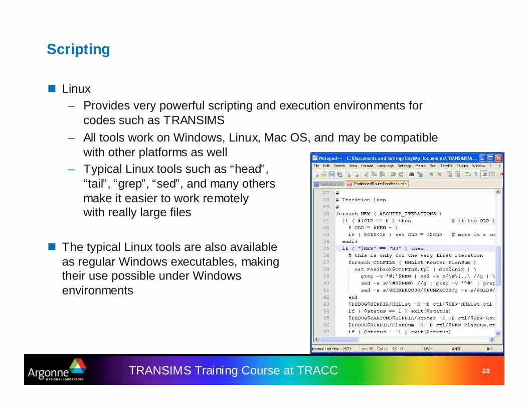
– For editing, we recommend the freelyavailable NotePad++ editor (alsoavailable from SourceForge, justlike TortoiseSVN and TRANSIMS itself)
28TRANSIMS Training Course at TRACC
Scripting
� Linux– Provides very powerful scripting and execution environments for
codes such as TRANSIMS– All tools work on Windows, Linux, Mac OS, and may be compatible
with other platforms as well– Typical Linux tools such as “head”,
“tail”, “grep”, “sed”, and many othersmake it easier to work remotelywith really large files
� The typical Linux tools are also availableas regular Windows executables, makingtheir use possible under Windowsenvironments
29TRANSIMS Training Course at TRACC
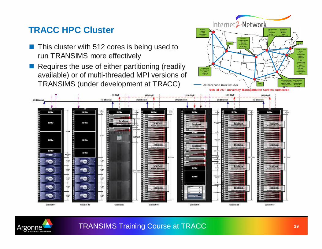
TRACC HPC Cluster
TAMULS U
Cleveland StateAkron
ToledoYoungstown
RutgersDelaw areVermont
MITRhode IslandC onnecticut
MassMorgan State
UMDCPHampton
George MasonGWU
94% of DOT University Transportation Centers connected
MontanaOr egonA laska
WashingtonIdaho
U C BerkeleyS an Jose S tate
C SUSBUC D avis
U NLV
CU NYUtah
Mississippi St ate North CarolinaSouth Florida Flor ida
Jackson State Central Flor idaTenn-Knoxville Penn St ate
GaTech Alabama
Ar kansasO klahoma State
MemphisMissouri
K ansas StateN ebr aska
Missour i-Rolla
Nort hw est er n MinnesotaIllinois W isconsinIowa State MichiganD etr oit Purdue
North Dakota St Michigan Tech
All backbone links 10 Gb/s
� This cluster with 512 cores is being used to run TRANSIMS more effectively
� Requires the use of either partitioning (readily available) or of multi-threaded MPI versions of TRANSIMS (under development at TRACC)
30TRANSIMS Training Course at TRACC
Credits and Acknowledgements
– GIS visualization materials were mostly developed at Argonne based on the TRANSIMS tools developed by AECOM for USDOT
– Chicago road and transit network data used in some of the examples was provided by the Chicago Metropolitan Agency for Planning
– USDOT provided the funding for the development of these trainingmaterials
– USDOT provided the funding for the TRACC computing center and the resources necessary to perform these training session