transboundary water cooperation in central … · tajikistan 1,1 62,9 64,0 744 7.6 ... major...
TRANSCRIPT

1
“TRANSBOUNDARY WATER COOPERATION IN CENTRAL ASIA”
Dr. Saghit Ibatullin, ChairmanExecutive Committee of International Fund for saving the Aral Sea

Aral Sea 1960 End of 2009
Surface Area
67,500 km2
(4th in the world)8,409 km2
(88% loss)
Level 53.4 m Large Aral = 26.5 m; Small Aral = 42 m
Volume 1090 km3 84.5 km3 (92% loss)
Average salinity
10 g/l (brackish) Large Aral > 100 g/l,In Western part is probably >200 g/l,In Eastern part (hyper saline);
Small Aral = 10‐14 g/l
The dynamics of the Aral Sea shrinkage
2

3
CountryVolume of runoff km3/year Irrigated lands Population
Syrdarya Amudarya Total thousand ha mln Kazakhstan 4,5 ‐ 4,5 560,5 3,1 *share of
population in the Aral Sea
BasinKyrgyzstan 27,4 1,9 29,3 477,7 5.3Tajikistan 1,1 62,9 64,0 744 7.6Turkmenistan ‐ 2,78 2,78 1752 6.7Uzbekistan 4,14 4,7 8,84 4259 29.7Afghanistan ‐ 6,18 6,18 250 8.0
Total 37,14 78,46 115,6 8043,2 60.4
Water and land resources of the Central Asian region

4
Indicators Measurement unit 1960 2007‐2012
Population mln 14,1 60,4
Irrigated agricultural lands thousand hectares
4510 8043,2
Irrigated land per capita hectares/per capita
0,32 0,131
Total water withdrawal km3/year 60,61 105,0
Total runoff to the Aral Sea km3/year 54,99 10,6
Key indicators of water and land resources use in the Aral Sea Basin

5

Major factors affecting transboundary water cooperation in Central Asia:
6
• Population growth: increasing deficiency of water resources, reduction of specific water availability in 3,5times, requiring additional annual 700‐800 mln m3 of water.
• Climate change: loss of glacier reserves, expected reduce of water flow by 10‐15%, growing frequency offloods and droughts.
• Consequences of the Aral Sea shrinkage resulted in the degradation of natural resources and ecosystemsdestruction: desertification, pollution and loss of biodiversity, water quality deterioration etc.
• Conflict of interests in the use of transboundary water resources between the upstream and downstreamcountries of the Aral Sea basin.
• The principles of Integrated Water Resources Management are not fully applied in the countries of CentralAsia.
• The need in the development of effective early warning systems and preventive measures to prevent andreduce risks and consequences of natural disasters.
• The outdated water saving technologies: lack of modern irrigation techniques, advanced methods of recyclingetc.

Glaciers of Central Asia
Glaciers presently contribute up to70% of the water flow in the majorriver systems of the region duringhot, dry summers.(TSNC‐Tajikistan Second National Communication, 2009).
7
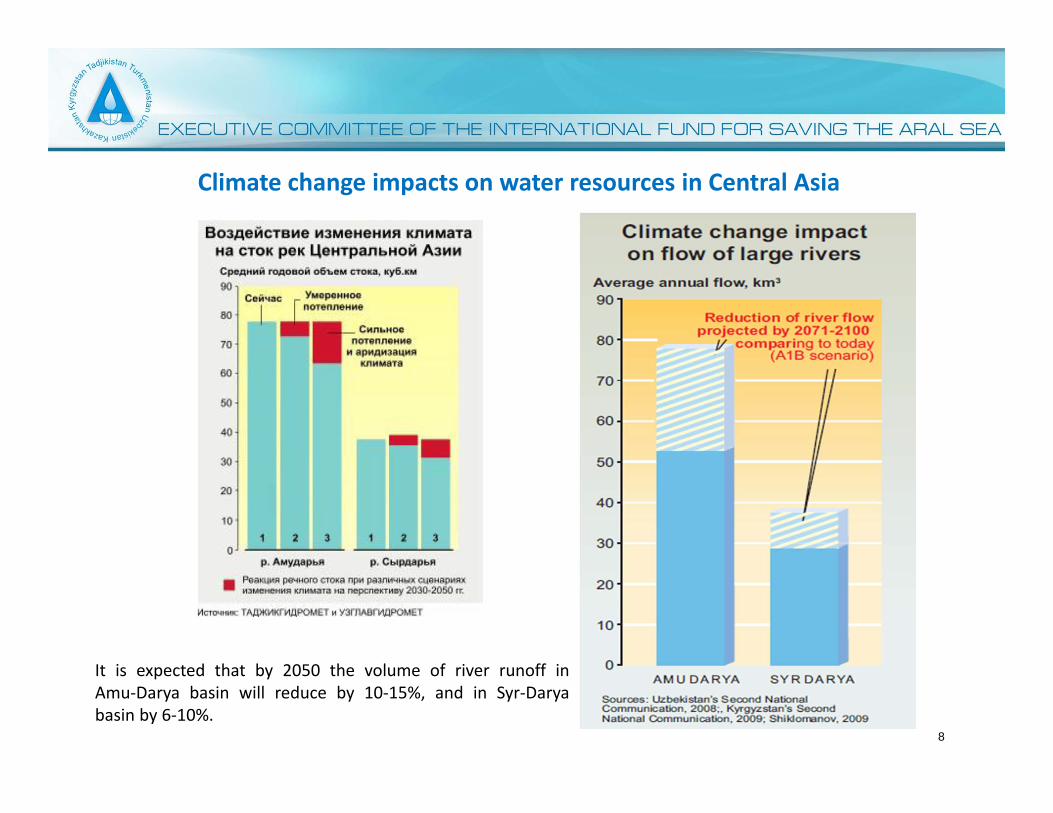
Climate change impacts on water resources in Central Asia
It is expected that by 2050 the volume of river runoff in Amu‐Darya basin will reduce by 10‐15%, and in Syr‐Darya basin by 6‐10%.
8

9
Organizational structure of IFAS

20 years of IFAS – an unique example of international coooperation • Joint Statement of Heads of states‐founders IFAS
(28th April 2009) – IFAS is the central institutionfor coordinating and addressing the fundamentalaspects of cooperation in the Aral Sea Basin.
• IFAS has contributed to: – development of new quality interstate
relations in the region;– Strengthened regional cooperation;– no conflict mechanism for resolving complex
issues in water use.– interaction between donor and international
organizations.
• A platform of dialogue among countries fordevelopment and implementation of bilateral,multilateral and international agreements.
• Assistance to the countries of the Aral Sea basinby developing Action Programmes (ASBP‐1‐2‐3).
10

ASBP ‐ 3 as the basis of the current International cooperation
• Development of Action Program onproviding assistance to the countries of theAral Sea Basin for the period of 2011‐2015(ASBP‐3) in consultations with nationalexperts and donor community.
• December 9th, 2010 – Internationalorganizations and the donor communitymade Statement about their full support tothe Program and their close partnershipwith EC‐IFAS.
• Main directions of ASBP‐3: – Integrated use of water resources– Environmental Protection– Socio‐economic development– Improving the institutional and legal
mechanisms
11

Cooperation with international organizations and donor community
12

Prospects of strengthening transboundary water cooperation in CA
• Implementing the long‐term regional Program ASBP‐3.
• Developing and implementing jointly IWRM plan in transboundary basins.
• Improving socio‐economic and environmental situation of the region.
• Improving the institutional structure of regional and basin organizations.
• Strenghtening and enlarging collaboration with international organizations and donor community.
• Ratifing previously prepared bilateral/multilateral agreements for transboundary cooperation, in
particular those that have been negotiated for a long time and are ready to be signed (agreements
stipulated in the 2009 Statement of Heads of IFAS state‐founders).
• Developing the interstate relations on the basis of international law and best practices in the
management and protection of transboundary water resources.
• Establishing a single interstate information system on water resources management.
• Building scenarios and economic models on shared water use and management aiming
at enhancing interstate cooperation, etc. 13

Options of canals track to deliver water from the Syr‐Darya river into the Saryshyganak Bay
14

The two‐level option is characterized by having high stability and good characteristics ofSaryshyganak water area.
Saryshyganak with the level of 50 m has large sizes:• The length is about 50 km, average width of 16 km and average depth of
5 m (maximum 11 m), sufficient to eliminate the process of eutrophication which leads todeath of juvenile fish.
• maximum mineralization is expected to be 5 g/l with subsequent decline to1.5‐2 g/l. The amplitude of water level fluctuations does not exceed 0.8 m., the estimatedperiod of filling Saryshyganak is 6‐7 years.
• Under this option the escapage (including fish) through the existing Kokaral dam is excluded.
The two‐level Northern Aral Sea with sea level of 42 m and Saryshyganak ‐ 50 m is mostrecommended for its stability in all aspects.
The proposed option of cascade regulation of the northern Aral sea
15
16