training available upon request y the n dot photogrammetry
TRANSCRIPT

Accessing Existing Geospatial Data Training Available Upon Request By
The NCDOT Photogrammetry Unit


Extract DEM (QL2 Lidar) Tool
LiDAR
•Light Detection and Ranging
•Active sensor unlike a camera which is a
passive sensor.
•Uses thousands of laser pulses/sec to
accurately measure distances to the earth’s
surface.
•Each LIDAR pulse is a laser beam of light
that reflects back to the LIDAR sensor.
•Each reflection is called a return and there
are multiple returns collected for each
laser pulse
•An X, Y, Z coordinate can be generated for
each return
•Intensity (strength of the return) is also
collected
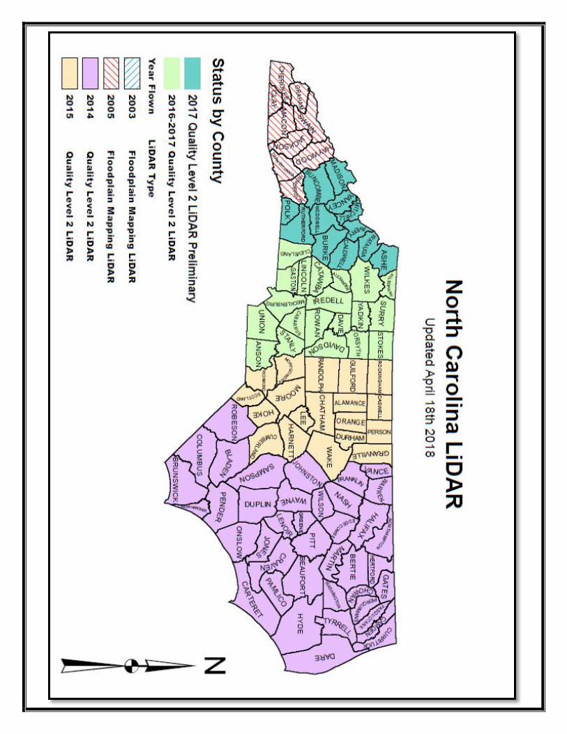
QL2 Elevation Model (2014 – 2017)
4 Meter Elevation Model (2001 – 2005 NC LiDar)
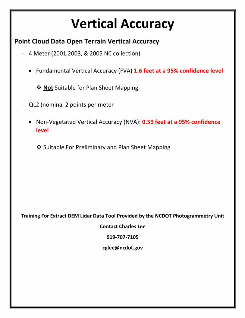
Vertical Accuracy Point Cloud Data Open Terrain Vertical Accuracy
- 4 Meter (2001,2003, & 2005 NC collection)
Fundamental Vertical Accuracy (FVA) 1.6 feet at a 95% confidence level
Not Suitable for Plan Sheet Mapping
- QL2 (nominal 2 points per meter
Non-Vegetated Vertical Accuracy (NVA): 0.59 feet at a 95% confidence
level
Suitable For Preliminary and Plan Sheet Mapping
Training For Extract DEM Lidar Data Tool Provided by the NCDOT Photogrammetry Unit
Contact Charles Lee
919-707-7105
NC
DO
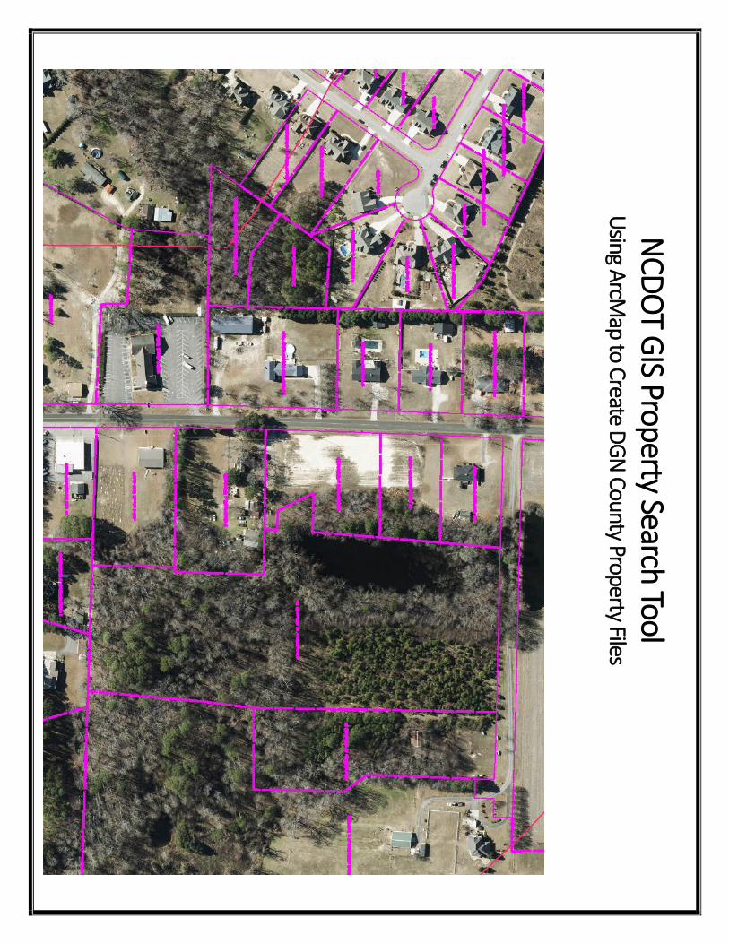
T GIS Property Search Tool
Using A
rcMap to Create D
GN
County Property Files

Produced File Examples
Training For Extraction of GIS Property Data Search Tool Provided by the NCDOT
Photogrammetry Unit
Contact Charles Lee
919-707-7105

N
CD
OT H
istorical A
erial Im
agery Se
arch To
ol U
sing A
rcMap
N
CD
OT Em
plo
yees (O
nly) C
an Search
Histo
rical Aerial Im
agery Usin
g ArcM
ap
Im
agery For Years 1
95
5 – 1
99
5 an
d 2
00
9 – 2
01
6 is A
vailable
N
CD
OT P
ho
togram
metry U
nit C
an Su
pp
ly High
Reso
lutio
n Scan
s Of R
equ
ested
Imagery Fo
r NC
DO
T Staff
Selected
Histo
rical Im
agery F
oot P
rints S
elected H
istorica
l Imag
ery Footp
rints o
f at A
rea o
f Interest

NO
TE: Ba
se Ima
ge is N
CO
neMa
p a
nd
Histo
ric Ima
ge is (R
DU
Airp
ort) from
Mission
M-2
52
Flow
n 0
3/08/1
968, 1
”=100
0’ P
ho
to Sca
le
Trainin
g For H
istorical Im
agery Se
arch P
rovid
ed
by th
e N
CD
OT P
ho
togram
metry U
nit
Co
ntact C
harles Le
e
91
9-7
07
-71
05
cglee
@n
cdo
t.gov

N
CD
OT H
istorical Aerial Im
agery Search Tool Using
ArcG
IS Online (A
GO
L)
Availab
le To Th
e Pu
blic Th
rou
gh G
O!N
C
Im
agery For Years 1
955
– 19
92
is Availab
le
N
CD
OT P
ho
togram
metry U
nit C
an Su
pp
ly High
Reso
lutio
n Scan
s of R
equ
ired Im
agery
Service P
rovid
ed Fo
r a Fee

Trainin
g For N
CD
OT H
istorical A
erial Image
ry Search
Too
l Usin
g AG
OL, P
rovid
ed b
y the
NC
DO
T Ph
oto
gramm
etry U
nit
Co
ntact C
harles Le
e
91
9-7
07
-71
05
cglee
@n
cdo
t.gov
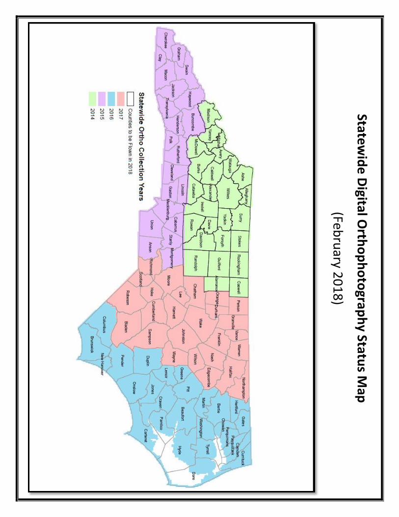
Statew
ide
Digital O
rtho
ph
oto
graph
y Status M
ap
(Febru
ary 20
18
)