train - david bekaertdavidbekaert.com/download/train_manual.pdf · toolbox for reducing atmospheric...
TRANSCRIPT

-TRAIN-
ToolboxforReducingAtmosphericInSARNoise
(VisiblespectrumimagesatageostationaryorbitoverMexico,copyrightNOAA)
DavidBekaert
Version3beta
DistributedunderaGNU-GPLlicence
ToolboxforReducingAtmosphericInSARNoise–TRAIN
1
1 Introduction
TheToolbox forReducingAtmospheric InSARNoise–TRAIN– isdeveloped inaneffort to includecurrent state of the art tropospheric correctionmethods into the default InSAR processing chain.InitialdevelopmentwasperformedattheUniversityofLeeds.WerequestTRAINuserstoreferenceourpublicationofTRAIN:
Bekaert,D.P.S.,Walters,R.J.,Wright,T.J.,Hooper,A.J.,andParker,D.J.(2015c),StatisticalcomparisonofInSARtroposphericcorrectiontechniques,RemoteSensingofEnvironment,doi:10.1016/j.rse.2015.08.035
Inaddition,alsocitetheoriginalmethodswhereneeded.E.g.forourpower-lawmethodthisis:
Bekaert,D.P.S.,Hooper,A.J.,andWright,T.J.(2015a),Aspatially-variablepower-lawtroposphericcorrectiontechniqueforInSARdata,JGR,doi:10.1029/2014JB011558
Iwould like to acknowledge the contribution and help of Richard J.Walters, Hannes Bathke, andSimranSangha,andthesupportofTimJ.Wright,AndyJ.Hooper,andDougJ.Parker.Inaddition,IwouldliketothankZhenhongLi,theLeedsInSARgroup,aswellasotherCOMETmembersfortheirfeedback
TRAINisdistributedunderaGNUGPLlicence.Thetoolboxconsistsofacombinationofcommandlinescripts,shellscripts,andmatlabscripts.MoreinformationonsoftwareisprovidedinChapter3.TRAINisindependentoftheusedInSARprocessor,aslongasthedataconventionisfollowed.ThetoolboxiscompatiblewiththeStaMPSsoftware.FurtherinitialeffortshavebeenputtoincludeTRAINintothedefaultP-rateprocessingchain.
The manual provided with this toolbox is undergoing continuous development. Any feedback iswelcomed.PostquestionsandcommentstotheTRAINhelpforum.Inordertoposttotheforum,youwillneedtosubscribeandprovideasmalldescription.Thelatterisonlyusedtoseparatespamfromactual users. You can search for answered questions without being a member of the group.https://groups.google.com/forum/?hl=en#!forum/TRAIN_support
Throughout this manual command line commands are indicated in blue. Matlab commands areindicatedtobeinthematlabenvironment,i.e.commandisproceededby>>.Redreferstoinputsthatneedtobesetbytheuser.Descriptionofthematlabfunctionscanbeobtainedbytypinghelpandthefunctionname inmatlabe.g. >>help function_name. Inmatlaball theprocessingparameters arecontainedintheparms_aps.matfile.Parametervaluescanberetrievedby>>getparm_apsforthefulllistorthrough>>getparm_aps('parameter_name')fortheparameter_nameparameter.Onthe
ToolboxforReducingAtmosphericInSARNoise–TRAIN
2
other hand parameters can be changed by the user by using the >setparm_aps('parameter_name',new_value).Atthefirstrunthedefaultparameterswillbeloaded.Toresetatanytimeonoftheparameterstothedefaultvaluedo:
>setparm_aps('parameter_name',NaN)
TRAINincludes:
Weatherballoonsoundingdelays:§ Balloonsoundingdownloadscript§ Balloonsoundingdelayestimationtool(stationlocationonly)
TroposphericcorrectiontechniquesforInSAR:§ Phase-based-Power-lawcorrection
o Inputparameterscanbeestimatedfromsoundingdatao Optiontohavevariablepower-lawcoefficientsbetweeninterferogramso Fixedwindowsgenerationofusingmountainridgeinformation
§ Phase-based-Linearcorrectiono Fullinterferogramornon-deformingregion
§ Spectrometer-MERIScorrection(currentlyonlyEnvisatsupport)o Inputparameterscanbeestimatedfromsoundingdatao OptiontovaryconversioncoefficientsforeachSARdateo Autore-projectiontogeo-coordinates
§ Spectrometer-MODIScorrectiono Inputparameterscanbeestimatedfromsoundingdatao OptiontovaryconversioncoefficientsforeachSARdateo AutodownloadandmergingusingOSCARserviceo Re-calibrationoptionofMODISPWVwithrespecttoMERISPWV
§ Weathermodelcorrectiono Downloadofweathermodeldatao ERA-IfromtheBADCandECMWFdataserverso MERRAandMERRA2o GenericAtmosphericCorrectionOnlineServiceforInSAR(GACOS)
§ Weathermodel–WeatherResearchandForecastingModel(WRF)correctiono Includingdownloadscriptofweathermodeldatao WRFinputfilegeneration
ToolboxforReducingAtmosphericInSARNoise–TRAIN
3
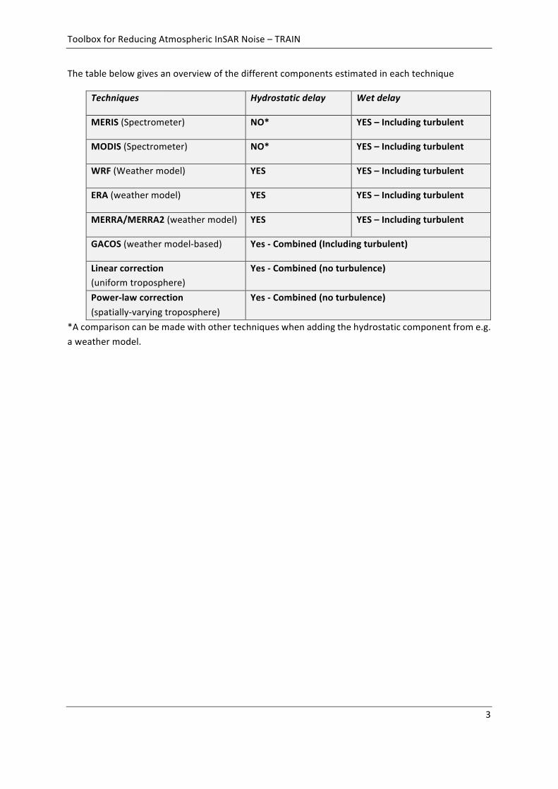
Thetablebelowgivesanoverviewofthedifferentcomponentsestimatedineachtechnique
Techniques Hydrostaticdelay Wetdelay
MERIS(Spectrometer) NO* YES–Includingturbulent
MODIS(Spectrometer) NO* YES–Includingturbulent
WRF(Weathermodel) YES YES–Includingturbulent
ERA(weathermodel) YES YES–Includingturbulent
MERRA/MERRA2(weathermodel) YES YES–Includingturbulent
GACOS(weathermodel-based) Yes-Combined(Includingturbulent)
Linearcorrection(uniformtroposphere)
Yes-Combined(noturbulence)
Power-lawcorrection(spatially-varyingtroposphere)
Yes-Combined(noturbulence)
*Acomparisoncanbemadewithothertechniqueswhenaddingthehydrostaticcomponentfrome.g.aweathermodel.
ToolboxforReducingAtmosphericInSARNoise–TRAIN
4
2 Contents
1 Introduction...............................................................................................................1
2 Contents.....................................................................................................................4
3 Configuration.............................................................................................................63.1 Matlab............................................................................................................................63.2 Beam...............................................................................................................................63.3 NCL.................................................................................................................................63.4 GMT................................................................................................................................63.5 Python............................................................................................................................73.6 OSCARJPL–MODISservice.............................................................................................73.7 ECMWFWEBAPI..............................................................................................................73.8 StaMPS............................................................................................................................73.9 WRF................................................................................................................................8
4 PreparingyourdataforprocessingwithTRAIN...........................................................9
5 Downloadingofsoundingdata.................................................................................115.1 Download......................................................................................................................115.2 LoadinginMatlabandsavinginto.matfiles..................................................................12
6 Computationofsoundingprofiledelays...................................................................136.1 Soundingdataformat....................................................................................................136.2 Computationofsoundingdelays...................................................................................13
7 Phase-based-Lineartroposphericcorrection...........................................................157.1 Fullinterferogrambased...............................................................................................157.2 Non-deformingregion...................................................................................................15
8 Phase-based-Powerlawcorrection..........................................................................168.1 Step0:Definingmountainridges...................................................................................178.2 Step1:Estimatepower-lawcoefficientfromsoundingdata..........................................178.3 Step2:Rotateandinterpolatetoaregulargridtogetherwithpower-lawscaling..........198.4 Step3:1Dandor2DFourierbandfiltering....................................................................218.5 Step4:Computationofthetroposphericdelays............................................................228.6 Step5:SelectionofthePower-lawbandsbycomparingRMSEtoanothertechnique....23
9 Spectrometer-MODIScorrection.............................................................................259.1 DownloadingandcroppingofMODISdata....................................................................259.2 Step1:Spectrometerconversionparameterestimationfromsoundingdata.................269.3 Step2:ComputingtheindividualSARdelays.................................................................279.4 Step3:ComputingtheMODIStroposphericInSARdelays..............................................29
10 Spectrometer-MERIScorrection(Envisatonly)....................................................30
ToolboxforReducingAtmosphericInSARNoise–TRAIN
5
10.1 DownloadingofMERISdata..........................................................................................3010.2 ProjectingtheMERISdatatoWGS84............................................................................3110.3 Settingthedirectorystructure......................................................................................3110.4 Step1:MERISconversionparameterestimationfromsoundingdata............................3210.5 Step2:ComputingtheindividualSARdelays.................................................................3310.6 Step3:ComputingtheMERIStroposphericInSARdelays...............................................34
11 Spectrometer-MODISPWVcalibration................................................................3611.1 LoadandsavePWVofMODISandMERIS......................................................................3611.2 ComputationoftheMODISPWVre-calibrationfactors.................................................3611.3 Re-calibrateMODISPWVdata.......................................................................................36
12 Weathermodel-ERA-I/MERRA/MERRA-2/GACOScorrections.............................3712.1 Step0:Overviewofrequiredweathermodeldatafiles.................................................3812.2 Step1:Downloadofweathermodeldata.....................................................................38
12.2.1 ERA-IusingBADCoption..............................................................................................3912.2.2 GACOSproducts...........................................................................................................39
12.3 Step2:ComputingindividualSARdelays(zenith)..........................................................3912.4 Step3:ComputingtroposphericInSARdelays...............................................................40
13 Weathermodel-WeatherResearchandForecastingmodel.................................4213.1 RequiredfilesandgenerationoftheWPSandWRFinputfiles......................................4213.2 DownloadingtheCFSRandGFSdataanddirectoryset-up.............................................4313.3 RunningoftheWRFsoftware........................................................................................4313.4 Step1:ComputingindividualSARdelays(zenith)..........................................................4413.5 Step2:ComputingtheWRFtroposphericInSARdelays.................................................44
14 Plottingresults......................................................................................................4614.1 StaMPSplotting............................................................................................................46
Bibliography....................................................................................................................48
15 Versionchanges....................................................................................................4915.1 Version1beta:releasedversion....................................................................................4915.2 Version1:releasedversion............................................................................................4915.3 Version2beta:releasedversion....................................................................................4915.4 Version3beta:releasedversion....................................................................................50
ToolboxforReducingAtmosphericInSARNoise–TRAIN
6
3 Configuration
Tosetuptherequiredvariablessourcetheappropriatefileforyourshell.Ifyouareusingacshlikeshell,run:
sourceAPS_CONFIG.tcsh
Or,ifyouareusingabashlikeshell:
sourceAPS_CONFIG.sh
Ifyouunsureofwhichshellyouareusing,youshouldbeabletofindoutbyrunningthecommand:
echo$SHELL
Edit theAPS_CONFIGfileandupdatethepathof theAPS_toolboxtothe locationwhereyouhavedownloadeditto.Theconfigurefileneedstobesourcedoneachshellstart-up.Itisrecommendedtoaddthesourcingcommandtoyour.bashrcor.tcshrcfile
Belowalistisprovidedwithexternalsoftware’sthatareusedwithinthistoolbox.AllofthemarefreelyavailableexceptMatlab.Notallofthemarerequiredwhenrunningspecificpartsofthetoolbox.
3.1 MatlabThemainsoftwareusedthroughoutthistoolbox.ThedevelopmentofthetoolboxhasbeendoneusingMatlab 2012 and 2013.While not tested it is expected to runwithout large problemswith olderversions.
3.2 BeamFreedownloadablesoftware fromESA,http://www.brockmann-consult.de/cms/web/beam/,whichallowsyouto loadsatellitedataandperformimageoperationlikere-projectiontoWGS84format.TheBeam(VISAT)softwareisonlyusedfortheMERIScorrectionpartofthetoolbox.Notethatothersoftwaremightbeabletodoare-projectionaswell.
3.3 NCLFreedownloadablesoftwarefromhttp://www.ncl.ucar.edu/index.shtml,whichisusedtoconvertGRIB1andGRIB2reanalysisdateintonetcdfformat.ThissoftwarewillbeneededwhenusingweathermodeldatafromtheUS.
3.4 GMTGMT is an open source software that can be downloaded for free and which is for the auxiliarytroposphericcorrectionmethods.TRAINhasbeentestedforGMTversionpriortoversion5.Download

ToolboxforReducingAtmosphericInSARNoise–TRAIN
7
fromhttp://gmt.soest.hawaii.edu/gmt/gmt_download.html.UsershouldmakesureGMTisaddedtotheirstart-upshellsuchgmtcanbecalledfromwithinmatlab.
3.5 PythonPythonisusedtoautomatesomeroutines,whichcanalsobecompletedmanually.E.g.thisincludesthebatchorderinganddownloadofERA-IdatafromtheECMWFwebsite,andtheautomaticallybatchre-projectionoftheMERIScoordinatesystem.Whenusingtheautomatedoptions,onewillalsoneedtoaddthePYTHONPATHwiththelocationofthepackagesintheAPS_CONFIGfile.
3.6 OSCARJPL–MODISserviceFortheMODISspectrometerestimate,thedownloadingandcroppingreliesontheOSCARJPLonlineservice.DatafetchinganddownloadingcanbedoneusingtheirprovidedPythonscripts.Downloadtheseathttp://oscar.jpl.nasa.govandupdatethelocationoftheget_modis.pyinyourAPS_CONFIG.shorAPS_CONFIG.tcshfile.NoteOSCARserverincludesMODISdatatill2013only.
3.7 ECMWFWEBAPITheECMWFwebapicanbeusedtobatchorderanddownloadtheERA-IfromtheECMWFwebsite.Downloadthepackageandfollowtheguidelinesasgivenat:
https://software.ecmwf.int/wiki/display/WEBAPI/Accessing+ECMWF+data+servers+in+batch.
The python package can be installed in the Python folder of the APS toolbox, which will beautomaticallysourcedintheAPS_CONFIGfile.InstallingthepackageatanotherlocationwillrequireyoutoupdatetheAPS_CONFIGfilesuchthepackageisaddedtothePYTHONPATH.ToruntheAPI,ausernameandpasswordfromECMWFarerequired,andaWEBAPIpasswordwillneedtoberequestedlinkedtoyouraccount.Oncegiven,putyouraccountinformationinthehidden~/.ecmwfapircfileasinstructedontheECMWFwebsite.
3.8 GenericAtmosphericCorrectionOnlineServiceforInSAR(GACOS)NoAPIcallsarecurrentlysupportedbytheGACOSservice.Thiswillbeincludedunfuture.UserswillneedtodownloadtheproductsfromtheGACOSwebsite(http://ceg-research.ncl.ac.uk/v2/gacos/)manually.
3.9 StaMPSUserswhich are using this toolbox as a plug-in to StaMPS can use ps_plot of the StaMPSMatlabtoolboxtovisualisetheirtroposphericcorrectionresults.TRAINhasbeenintegratedwithStaMPSandrecognises the StaMPS structure. For the power-law tropospheric correction a lot of the requiredprocessing parameters are automatically extracted based on the StaMPS files. Note that for non-
ToolboxforReducingAtmosphericInSARNoise–TRAIN
8
processedStaMPSdata,theplottingwillfail,unlessalltherequiredfilesareprovidedintheStaMPSformat.Forinteresteduserssee:http://homepages.see.leeds.ac.uk/~earahoo/stamps/.
3.10 WRFTheWeatherresearchandForecasting(WRF)model,usedtorunyourownlocalweathermodelatahighresolution,canbedownloadedathttp://www2.mmm.ucar.edu/wrf/users/downloads.html.Youwillneedtoinstalltwocomponentsofthesoftware,WPSandWRF.
Asdifferentlibrariesandpackagesarerequired,itmightbeusefultofollowthecompilationtutorialstepbystep.http://www2.mmm.ucar.edu/wrf/OnLineTutorial/compilation_tutorial.php.Itwillhelpyoutofirstmakesureyoursystemissetupcorrectly,andthenwillhelpyoutoinstalllibraries,netcdf,mpich,andtomakesurethateverythingiscompatible.ItwillthenhelpyoutoinstallWRFV3andWPS.ForWRFinstallationrelatedquestionspleasecontactWRFsupport.

ToolboxforReducingAtmosphericInSARNoise–TRAIN
9
4 PreparingyourdataforprocessingwithTRAIN
TRAIN assumes the interferometric phase, height, anddate information to be stored in a specificformation.Belowitiselaboratedhowtosetthisstructureup.StaMPsuserscanskipthisstep,asthetoolboxwillbeautomaticallysetthepathstothecorrectvariablesintheparameterfile.
In the following n_p, refers to the number of points, while n_ifgs will refer to the number ofinterferograms.
Tip:WhenyouhaveadifferentselectionofpointsforeachinterferogramyoucanincludeNaN’sinthephasematrixforthosepixels.
Tosaveyoudatadosomethinglike:
>>save('hgt.mat','hgt')
hgt_matfile=[pwd'hgt.mat'] Topography,storedinacolumnvectorofsize[n_points1]inmeterunitsasvariable“hgt”.Thisisneededforthephase-basedcorrectionmethodsonly.
phuw_matfile=[pwd'phuw.mat'] Unwrappedinterferograms,storedasamatrixofsize[n_pointsn_ifgs]inradianunits,asvariable“phuw”.Thisisneededforthephase-basedcorrectionmethodsonly.
ll_matfile=[pwd'll.mat'] Geo-coordinates,storedinamatrixwithsize[n_points2]andinitscolumnsthelongitudeandlatitude,specifiedasdegrees,asvariable“lonlat”.Neededforallcorrectionmethods.
ifgday_matfile=[pwd'ifgday.mat'] Interferogramdatesstoredasamatrixwithnameifgdayandsize[n_ifgs2].Themasterimageisinthefirstandslaveinthesecondcolumnrespectively.SpecifydatesanumericvalueinYYYYMMDDformat,andasvariable“ifgday”.Neededforallcorrectionmethods.

ToolboxforReducingAtmosphericInSARNoise–TRAIN
10
UTC_sat=['HH:MM'] UTCtimeofthesatellitepassoveryourstudyarea.Itisspecifiedasastringinatwo-digithourandtwo-digitminutestringformat“HH:MM”.Acolonneedstobeincludedinbetween!NeededforallweathermodelandMODIScorrectionmethods.
look_angle=21/180*piorpathtofile Theincidenceangleismostcorrect,butalternativethelookangle[rad]usedintheprojectiontothelineofsight.Bydefaultthisissetto21degrees.AlternativeafilecanbespecifiedinwhichthelookangleforeachpixelorPScanbegiven.Thisneedstobeacolumnvectorofsize[n_points1]withtheanglein[rad]savedas“la”variable.radianssavedas“la”variable.Neededforallcorrectionmethodsexceptphase-basedcorrectionandMERIS.
demfile=[pwd'dummy.dem']
or=[pwd'dummy.grd']
ThepathtotheDEM_file.Fewoptionsareincluded:1)usinga“.grd”file,2)aDEM_filewithcorrespondingDEM_file.rscfile,3)aDEMfilewithDEM_filexmlfile(isce-like).Foroption2theDEM_file.rscshouldcontaintheassociatedWIDTH,LENGTH,X_STEP(resolution),Y_STEP(-1*resolution),X_FIRSTandY_FIRST(upperleftcorneroftheDEM),andoptionaltheFORMAT.XandYrefertolongitudeandlatitude.Youcanuseconstruct_dem.shtomakeyouDEMfile.Neededforallweathermodelcorrectionmethods.
ToolboxforReducingAtmosphericInSARNoise–TRAIN
11
5 Downloadingofsoundingdata
Thisstepisnotrequiredforthelineartopography-phasecorrection.Optionalitcanbeusedforthespectrometer(MERIS/MODIS)andpower-lawcorrectiontogetanestimateforthescalingcoefficientsofthecorrectiontechniques.Incasenosoundingdataisdownloadedthedefaultvalueswillbeloadedforthosetechniquesinstead.Theusercanmanuallychangethevaluesaswell.
Soundingdatacangiveagoodindicationonhowdelaysvarywithinyourregionofinterest.However,notethatsoundingdelaysareoftenacquiredatfixedtimesof00UTCand12UTCandthustheremightbeanoffsetbetweenyourradaracquisitionoverwhichtheatmosphericconditionsmighthavebeenchanged.RetrievethosesoundingacquisitionstheclosesttoyourSARacquisition.
5.1 DownloadBelowthe instructionsareprovidedonhowtoautomaticallydownloadballoonsoundingfromtheUniversityofWyoming(pleaseacknowledgethesourcedatainyourwork).
cp$APS_toolbox_scripts/sounding_download.
Edit theparameters insounding_downloadtoyour regionof interestandrunsounding_downloadfromthecommandline.
Parametername Description
station Thestationnumberofthesoundingstationtheclosesttoyourregionofinterest.Toidentifythestationnumberconsultthesoundingmapathttp://weather.uwyo.edu/upperair/sounding.html
region Thisistheregionswhereyoursoudingstationislocated.Thisiseither"eu"forEurope,"na"forNorthAmerica,"af"forAfrica.WhengoingtothewebsiteyoucanfindtheregionofthestationwithintheURL.
year Theyearsofsoundingdatathatneedstobedownloadede.g."201020112012".
month Themonthsoftheyearthatneedstobedownloadede.g."010203"forJanuarytillMarch.
day Thedaysofthemonththatneedstobedownloadede.g."28293031".
savepath Thefullpathwherethesoundingdataneedstobesavedto.

ToolboxforReducingAtmosphericInSARNoise–TRAIN
12
ThedatawillbedownloadedwhenavailableandsavedasaYYYYMMDD_HR.txtfilesfollowingtheregion/station_nr/YYYYMMDD_HR.txtdirectorystructure.
5.2 LoadinginMatlabandsavinginto.matfilesNextallthe“.txt”filesareloadedintoMatlabandsavedas“.mat”fileswiththeatmosphericvariables(P,T,h,andRH)storedasassumedbyotherroutinesinthistoolbox.Launchmatlabandsetthesoundingdatalocationusingsetparm_aps:
Parameteranddefaultvalue Description
sounding_dir=[pwd'/sounding_data'] Directorystringwherethesoundingdataisdownloadedto.Usefullpath.
Nowloadthesoundingdataintomatlabbyrunning:
>>load_sounding

ToolboxforReducingAtmosphericInSARNoise–TRAIN
13
6 Computationofsoundingprofiledelays
ThisMatlabscriptallowsforthecomputationofthesoundingdelays.Godirectlytothepower-laworMERIS/MODISchapterwhenyouwanttousesoundingdatatoestimatetheinputcoefficientsofthecorrectionmethod.
6.1 SoundingdataformatNomodificationofthefilestructure isneededwhenthesoundingdatahasbeenloadedusingtheload_soundingscriptaselaboratedinChapter5.Whendonesothisstepcanbeskipped.
AllthesoundingdatashouldbeloadedintoMatlabandsavedintothedate'YYYYMMDD'andUTC‘HR’ format as “YYYYMMDD_HR.mat” files. The variableswithin thismat files are the ‘P’ pressure(hPa),‘T’thetemperature(degrees),‘RH’therelativehumidity(%)and‘h’theheightsin(m).Afterhavingconstructedvectorsforeachofthesevariables,ofthesamelength,dothefollowingtosavethem:
>>save('YYYYMMDD_HR.mat','P','T','RH','h')
6.2 ComputationofsoundingdelaysThesoundingprogramcomputestherefractivity,themeanLOSdelay(phase[rad]anddisplacement[m]),thecorrespondingheightsandappendsthisinformationtotheexisting“YYYYMMDD_HR.mat”files.Inaddition,asingleestimateforthepowerlawcoefficientswillbegivenasoutputbasedonthefull sounding period. It can be neglected when not needed. More sophisticated power-law andspectrometercoefficientestimation,includingseasonalvariationandSARdatespecificestimates,arecontainedinthechapterofthepower-lawandMERIScorrection.
Delays are computed based on the user processing parameters, given below and which can beretrievedusingthe>>getparm_apsandmodifiedusingthe>>setparm_apsfunctions.
Tocomputethedelays,type:
>>sounding

ToolboxforReducingAtmosphericInSARNoise–TRAIN
14
Parameteranddefaultvalue Description
sounding_dir=[pwd'/sounding_data'] Directorystringwherethesoundingdataisdownloadedto.Usefullpath.
sounding_time_stamp=['00';'12'] TheUTCacquisitiontimesofthesoundingdatatobeusedintothecomputation.Bydefaultthisissetto00and12UTC.Needstobespecifiedasacolumnvectorstring.
sounding_start_date=[] Startdateofthesoundingdatatobeusedintothecomputation,specifiedasastringin‘yyyymmdd’format.Bydefault[],theearliestdateisused.
sounding_end_date=[] Enddateofthesoundingdatatobeusedintothecomputation,specifiedasastringin'yyyymmdd'format.Bydefault[],thelatestdateisused.
sounding_h0=0 Theheightinkmunitstillwhichthedelaysarecomputed.Whensetto0sounding_h0iscomputedtotheheightatwhichthenetdelayisapproximately0.Noteforindividualdelaysyoumightwanttoincreasethisvalue.
sounding_errror_promp='n' Crashesaresuppressed(default).InsteaderrormessageareoutputtedanddataispatchedwithNaNwhensetto'n'.
look_angle=21/180*piorpathtofile Theincidenceangleismostcorrect,butalternativethelookangle[rad]usedintheprojectiontothelineofsight.Bydefaultthisissetto21degrees.AlternativeafilecanbespecifiedinwhichthelookangleforeachpixelorPScanbegiven.Thisneedstobeacolumnvectorofsize[n_points1]withtheanglein[rad]savedas“la”variable.
lambda TheradarwavelengthoftheSARsatelliteinm.Thisisusedtoconvertthedelaytowardsaphasedelay.Bydefaultlambdaissettobe0,0562m.
ToolboxforReducingAtmosphericInSARNoise–TRAIN
15
7 Phase-based-Lineartroposphericcorrection
Alineartroposphericcorrectioncanbecomputedbasedonthephaseandtopographicinformationbytyping:
>>aps_linear
Outputissavedintoa“tca2.mat”or“tca_sb2.mat”asthe“ph_tropo_linear”variable.
Therelationcaneitherbeestimatedbasedonthefull interferogramorforaselectednon-deforming region. Support it included for interferograms with varying pixel selection in time, byintroducing themasNaN in those interferogramswhere thepixel isnot included.Theparameterswhichareusedinaps_linearare:
Parameteranddefaultvalue Description
hgt_matfile=[pwd'hgt.mat'] Fullfilepathcontainingthetopography,storedinacolumnvectorofsize[n_points1].
phuw_matfile=[pwd'phuw.mat'] Fullfilepathoftheunwrappedinterferograms,storedasamatrixofsize[n_pointsn_ifgs].
ll_matfile=[pwd'll.mat'] Fullfilepathofthegeo-coordinates,storedinamatrixwithsize[n_points2]andinitscolumnsthelongitudeandlatitude.
non_defo_flag='n' Bydefaultthecorrectionisperformedbasedonthefullinterferogram.Putto'y'tousethenon-deformingestimation.
7.1 FullinterferogrambasedBy default the 'non_defo_flag' is set to 'n', whichwill force the computation of the troposphericrelationbetweenphaseandtopographybasedonthewholeinterferogram.
7.2 Non-deformingregionTousethenon-deformingregionturnthe'non_defo_flag'intheparms_apslistonbytyping:
>>setparm_aps('non_defo_flag','y')
Notethatturningthisfunctionalityon,requiresyoutohaveafile“non_defo.mat”withinitavariable“poly”,beingamatrixwithinitscolumnsthelongitudeandlatitudeofthenon-deformingregion.Tosavesuchavariabledo:>>save('non_defo.mat','poly').
ToolboxforReducingAtmosphericInSARNoise–TRAIN
16
8 Phase-based-Powerlawcorrection
ThistechniqueiscontainedinBekaertet.al.(2015a,2015b).Anexpansionofthepowerlawmethodusingtheridgeapproach,comparingitwiththeothertroposphericcorrectionmethodsinTRAINovermultiple regions is documented in Bekaert et al. (2015c). The following section describes theprocessingstepstogetherwiththerequiredinputparametersforeachstep.Outputissavedintoa“tca2.mat”or“tca_sb2.mat”asthe“ph_tropo_powerlaw”variable.
Theprogramcanbecalledby>>aps_powerlawforwhichallprocessingstepswillberun.Individualstepscanberunby:
>>aps_powerlaw(start_step,end_step)
Optionalsteps:
Belowthedifferentstepsareelaborated.Step0(ridgedefinition)andstep1(coefficientestimationfromsoundingdata)areoptionalsteps:
Instep0theusercanusetheDEMinformationtodefinetheindividualregionsinwhichthepowerlawrelationshipisestimated.Bydefault(powerlaw_ridge_constraint=‘n’)thisstepisskipped,withthedifferentregionsdefinedbyapproximatelysquarewindows,wheretheusercontrolsthenumberofwindows(powerlaw_n_patches)andthepercentageoverlap(path_overlap).
In step 1 the power-law decay coefficient and height at which the net delays have reduced toapproximatelyzeroisestimatedfromthesoundingdata.Bydefaultandincasenosoundingdataisavailable ('sounding_data flag is set 'n') this step is skipped, and the default or user-definedcoefficientswillbeloaded.FormoreinformationonhowtoobtainsoundingdataandtherequireddatastructureseeChapter5ofthemanual.
Theselectionofanon-contaminatedfrequencybandisnotautomated.Youwillneedtoknowwhichfrequencybandtouseinadvance,orbyvalidationwithanotherindependenttechnique,e.g. MERIS, ERA, etc. Beside the tectonic deformation also other signals can bias specificfrequency bands like for example the higher spatial frequencies in case of atmosphericturbulence.
Alternatively,theusercanassumeoneoftheothertechniquesasreference,andevaluatetheRMSE of the different power-law bandswith respect to it. By comparing the average RMSEbetweenthepower-lawbandsandthereferenceonemightgetanideawhichbandmightbebesttocontinuewith.Thisisincludedinstep5andcurrentlyonlysupportedforStaMPSusers.InfuturethiswillbegeneralizedforotherInSARprocessingmethods,butfornotonecouldopttomakeavisualcomparisontofindasuitableband.
ToolboxforReducingAtmosphericInSARNoise–TRAIN
17
8.1 Step0:DefiningmountainridgesThisstepisoptional.Youcandecideeithertohaveyourregiontobesplitintomultipleapproximatelysquarewindows[Bekaertet.al.,2015a],oryoucanchoosethewindowstofollowmountainridgesasboundary [Bekaert et al., 2015c]. Choosing for the ridge approach can be enabled by using >>setparm_aps(‘powerlaw_ridge_constraint’,’y’)
Parameteranddefaultvalue Description
powerlaw_ridge_constraint=‘n’ Whensetto‘y’windows/patchesaredefinedbasedonmountainridges.Notethatwhen‘y’powerlaw_n_patchesandpatch_overlapwillnotbeused.
Torunthissteptype:
>>aps_powerlaw(0,0)
Nextfollowtheinstructionsasgiveninthescreen.Youwillneedtoclickonthetopographymaptodefineyourridges.Onceyouhavefinishedaridgepressthe“enter”button.Youwillbeaskediftheridgeisahardridgeornot.
Thedefinitionofahardridgebecomes importantoncetheestimatedrelationbetweenphaseandtopographyfromthedifferentwindowsisusedtoextrapolatetheestimatetoagivenlocation(pixel)withinthestudyregion.Onlywindowsnotblockedbyahardridgewillcontributetotheweightedestimateofanindividualpointlocation.Softridgescanbeusedtosplitaregionintomultiplewindows.
Note:Definedridgesneedtoextendslightlyoutsidetheredpolynomial(InSARconvexhull).DependingonyourInSARdataset,thispolynomialcouldcovernodataregions.Theintersectionbetweenridgesandtheredpolynomialisusedtodefinesub-regions.OnlyInSARobservationswithinasub-regionwillcontributetothesub-regionestimate.
8.2 Step1:Estimatepower-lawcoefficientfromsoundingdataThisstepisoptionalandwillusedefaultvalueswhenskipped.ToenablethismethodsoundingdataneedstobedownloadedaccordingtoChapter5.
>>setparm_aps('sounding_data','y')
>>setparm_aps('sounding_dir',string_with_your_path)

ToolboxforReducingAtmosphericInSARNoise–TRAIN
18
Twooptionsexist forthecoefficientestimation.Bydefaultameanvaluewillbeestimatedforthepower-lawcoefficientsusingthefullsoundingdaterange('sounding_sensitivity'='n').However,thiscanbechangedsuchthepower-lawcoefficientsareestimatedforeachspecificSARdata,afterwhichthe mean is taken to estimate the power-law coefficients for each individual interferogram. Inaddition,thereistheoptiontomakeasensitivityanalysisofthepower-lawcoefficients.Belowthedifferent option are summarised together with their specific parameters.Modify these using thesetparm_apsfunction.
Estimationoption Descriptionofparameterscontrollingoption
Ameancoefficientforallinterferograms(defaultoption)
'sounding_sensitivity'is'n'.Thismethodisnotrecommendedforlargesoundingperiods.Itisrecommendedinsteadtousethesensitivityanalysisandmanuallysetameanvalue.
Individualcoefficientsforeachinterferogram
'sounding_sensitivity'and'sounding_ifg_dates'areboth'y'.Intotal15daysbeforeandaftertheSARdateareusedtocomputethemeandelay.
Sensitivityanalysis 'sounding_sensitivity'issetto'y',while'sounding_ifg_dates'issetto'n'.Thenumberofmonthsoverwhichthemeandelayiscomputedisgivenby'sounding_months'.Thelatterisbydefault1month.
Both h0 and a are estimated from the sounding data. h0 corresponds to height at which thetroposphericnetdelayshavereducedtoapproximatelyzero.Itisestimatedbymakingmanynet-delaycombinationsandrequiressounding_h0tobesettozero.
>>setparm_aps('sounding_h0',0)
acorrespondstothepower-lawdecaycoefficientandisdefinedastheslopeofthemeandelayversusheightcurveinthelog-logdomain.Itisestimatedfromzeroelevationuptosounding_h_alpha_thres(kmunits).
>>setparm_aps('sounding_h_alpha_thres',4)
Below all remaining parameters used for this step are summarized. To run the estimation of thesoundingdatacoefficientstype:
>>aps_powerlaw(1,1)
ToolboxforReducingAtmosphericInSARNoise–TRAIN
19
Parameteranddefaultvalue Description
sounding_time_stamp=['00';'12'] TheUTCacquisitiontimesofthesoundingdatatobeusedintothecomputation.Bydefaultthisissetto00and12UTC.Needstobespecifiedasacolumnvectorstring.
sounding_start_date=[] Startdateofthesoundingdatatobeusedintothecomputation,specifiedasastringin'yyyymmdd'format.Note,unlikeforthesoundingdelaychapter,adateneedstobespecified!
sounding_end_date=[] Enddateofthesoundingdatatobeusedintothecomputation,specifiedasastringin'yyyymmdd'format.Note,unlikeforthesoundingdelaychapter,adateneedstobespecified!
sounding_h0=0 Theheightinkmunitstillwhichthedelaysarecomputed.Whensetto0sounding_h0iscomputedtotheheightatwhichthenetdelayisapproximately0.
sounding_h_alpha_thres=4 Lowerrangeofsoundingheightsinkm,forwhichthepower-lawdecaycoefficientalphaisestimated.Itisrecommendedtohavethisvaluearoundorabitalargerthanthemaximumtopography.
sounding_errror_promp='n' Crashesaresuppressed(default).InsteaderrormessageareoutputtedanddataispatchedwithNaNwhensetto'n'.
Obtainedresultscanbere-processedordisplayedbyre-runningthisstep:>>aps_powerlaw(1,1)
8.3 Step2:Rotateandinterpolatetoaregulargridtogetherwithpower-lawscaling
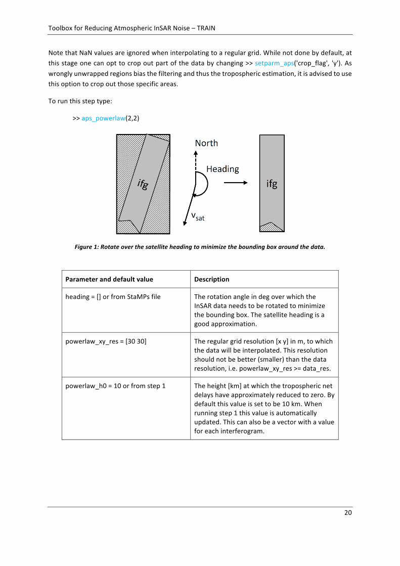
Tominimizeband-filteringeffects,theInSARdataisrotatedovertheheadingangletodecreasewhitespacearound the InSAR track, seeFigure1. Inorder toperform theFourier transform thedata isinterpolatedtoaregulargridwiththesamplingcontrolledbypowerlaw_xy_res.ThesamplingshouldnotbemadebiggerthantheresolutionofyouInSARdata.Next,thetopographyisscaledaccordingtothepower-lawrelationship.Anoverviewoftheusedinputparametersisgivenbelow.
ToolboxforReducingAtmosphericInSARNoise–TRAIN
20
NotethatNaNvaluesareignoredwheninterpolatingtoaregulargrid.Whilenotdonebydefault,atthisstageonecanopttocropoutpartofthedatabychanging>>setparm_aps('crop_flag', 'y').Aswronglyunwrappedregionsbiasthefilteringandthusthetroposphericestimation,itisadvisedtousethisoptiontocropoutthosespecificareas.
Torunthissteptype:
>>aps_powerlaw(2,2)
Parameteranddefaultvalue Description
heading=[]orfromStaMPsfile TherotationangleindegoverwhichtheInSARdataneedstoberotatedtominimizetheboundingbox.Thesatelliteheadingisagoodapproximation.
powerlaw_xy_res=[3030] Theregulargridresolution[xy]inm,towhichthedatawillbeinterpolated.Thisresolutionshouldnotbebetter(smaller)thanthedataresolution,i.e.powerlaw_xy_res>=data_res.
powerlaw_h0=10orfromstep1 Theheight[km]atwhichthetroposphericnetdelayshaveapproximatelyreducedtozero.Bydefaultthisvalueissettobe10km.Whenrunningstep1thisvalueisautomaticallyupdated.Thiscanalsobeavectorwithavalueforeachinterferogram.
Figure1:Rotateoverthesatelliteheadingtominimizetheboundingboxaroundthedata.
ToolboxforReducingAtmosphericInSARNoise–TRAIN
21
powerlaw_alpha=1.6orfromstep1 Thepower-lawdecaycoefficient.Bydefaultthisvalueissettobe1.6.Whenrunningstep1thisvalueisautomaticallyupdated.Thiscanalsobeavectorwithavalueforeachinterferogram.
powerlaw_DEM_corr=‘n’ Fortime-seriesinterferogramstheinputphaseusedforthetroposphericestimationcanbecorrectedfortheDEMassociatederror(correlatedwithbaseline).Bydefaultthisisnotdone.Itisnotrecommendedtoperformthiscorrectionwhenhavinglessthan5interferograms.SupportedforStaMPSusersonly.
Tip:Incaseofmemoryissues,itmightbeworthcheckingifthe“powerlaw_xy_res”resolutionissettoolow.AllInSARdataisinterpolatedtoaregulargridtoperformfilteringinthefrequencydomain.DependingonthesizeofyourInSARregionthiscanbecomeintensive.Inregardstothenextstep,theareaaroundyourInSARdatasetwillbemirroredbyhalfthelargestbandwidth.
Tip:Ifyourstudyareaisirregularshaped,therecanbeabetterrotationanglethantheheadingtominimizethewhitespacearoundtheInSARdata.
8.4 Step3:1Dandor2DFourierbandfilteringAtthisstagethescaledtopographyandphaseisfilteredindifferentbands.Bydefault,itisoptedtoperforma2DFourierbandfilter.However,inthosecaseswherethepercentageofthelargestfilterdimensionwithrespecttothesmallestdimensionisbiggerthan10%,thenthefilteringisswitchedautomaticallytoa1DFourierfilteringinthelargestdimensiononly.Thedifferentspatialbandfiltersarecontainedin'powerlaw_spatial_bands'.Itisadvisednottomakeyourspatialbandfiltersmuchbiggerthanyourmaximumdimension,asthiswouldintroducefilteringeffects.Thedataismirroredtoreduceedgeeffects,whichalsoincreasedthememoryneed.
Torunthissteptype:
>>aps_powerlaw(3,3)
ToolboxforReducingAtmosphericInSARNoise–TRAIN
22
Parameteranddefaultvalue Description
powerlaw_spatial_bands=
[20004000400080008000160001600032000320006400064000128000];
Spatialfilterbandgiveninmetersasatwocolumnmatrix[lower_bandhigher_band].Itisrecommendednottomakeyoufiltermagnitudesmallerthatthetwicethespatialresolutionofthedataset(Nyquistfrequency)andlargerthanthespatialextendofyourdataset.
Tip:Donotmakeyourband-filterssmallerthantwotimesthegridresolution(Nyquistprinciple).Makesuretheband-filterisreasonable.i.e.donotmakeitlargerthanyourInSARregion,asthiswillcausefilteringeffectstopropagateintheAPSestimation,andallowforsomedifferencebetweenthelowerandhigherextendoftheband-filter.
8.5 Step4:ComputationofthetroposphericdelaysInthisstepthetroposphericdelaysareestimated.Thisisdoneovermultiplesub-windows(patches)inthespatialfrequencybandsyoufilteredbefore.Currentlyameanisselectedfromtheindicatedfrequencybands,soitisimportanttoexcludethosebandsthatarecontaminatedbyothersignalsthantheatmosphere.
Incaseyoudonotknowwhichbandisnotcontaminated,youcancompareeachestimatedtroposphericbandcorrectionwithareferencetechnique.Careshouldbegivenasthereferencetroposphericcorrectionmethodcanhaveadifferentsensitivitytothetroposphericdelay(e.g.topographically-correlatedversusturbulent).Bydefaulttheestimateddelayforeachindividualbandisstored(powerlaw_all_bands=‘y’)inthevariabletca_bands_sb2.matortca_bands2.mat.Onceyouhaveidentifiedthebandyouwanttokeepyoucanreplaceupdatetheoriginalestimatedpowerlawdelaywiththatofyourpreferredband(band_number)using:
>>setparm_aps('powerlaw_kept',band_number)
ForStaMPSusersthecomparisonwithareferencetechniqueandthebandupdatingissupportedthroughstep5.
Toestimatethedelaystype:
>>aps_powerlaw(4,4)

ToolboxforReducingAtmosphericInSARNoise–TRAIN
23
Parameteranddefaultvalue Description
powerlaw_h0=10orfromstep1 Theheightinkmatwhichthetroposphericnetdelayshaveapproximatelyreducedtozero.Bydefaultthisvalueissettobe10km.Whenrunningstep1thisvalueisautomaticallyupdated.Donotmodifythisoronewillneedtore-runfromstep2onwards.
powerlaw_alpha=1.6orfromstep1 Thepower-lawdecaycoefficient.Bydefaultthisvalueissettobe1.6.Whenrunningstep1thisvalueisautomaticallyupdated.Donotmodifythisparameteroronewillneedtore-runfromstep2onwards.
powerlaw_spatial_bands=
[20004000400080008000160001600032000320006400064000128000];
Spatialfilterbandgiveninmetersasatwocolumnmatrix[lower_bandhigher_band].Itisrecommendednottomakeyoufiltermagnitudesmallerthatthetwicethespatialresolutionofthedataset(Nyquistfrequency)andlargerthanthespatialextendofyourdataset.Donotmodifythisparameter,oronewillneedtore-runfromstep3onwards.
powerlaw_ridge_constraint=‘n’ Whensetto‘y’windows/patchesaredefinedbasedonmountainridges.Thisflagsupersedesthepowerlaw_n_patches.i.e.when‘y’thewindowsdefinedinstep0areused.
powerlaw_n_patches=50 Numberofpatchesusingthisvalueisadaptedsuchapproximatelysquarepatchesaregenerated.Whenasinglepatchispreferred,putto0.Notethatthisparameterisnotusedwhenpowerlaw_ridge_constraint=‘y’.
patch_overlap=50 Percentageofthepatchoverlap.Notethatthisparameterisnotusedwhenpowerlaw_ridge_constraint=‘y’.
8.6 Step5:SelectionofthePower-lawbandsbycomparingRMSEtoanothertechnique
CurrentlythisstepisonlyincludedforStaMPS.Anexampleoftheapproachiscontainedin[Bekaertetal.,2015c].Whenrunningstep5theuserwillbepromptwhichtechniquehe/shewanttouseasreference in the RMSE computation of the bands. The reference technique should be one of the

ToolboxforReducingAtmosphericInSARNoise–TRAIN
24
techniquesthathavebeenprocessedbefore.Careneedstobetakenwhenusingoriginalphaseasinput,asthiswillhaveasuperpositionofdifferentsignals.Alsooneshouldnotethatthepower-lawhasawetandhydrostaticcomponentestimated.Whileoftensmall,itisbettertoaddahydrostaticcomponenttothespectrometerdatatoensurethatthesamepartofthetroposphericdelayisbeingobserved.Anoverviewofthedifferentcomponentsiscontainedintheintroductiontable.
Toestimatethiscomparisontype:
>>aps_powerlaw(5,5)

ToolboxforReducingAtmosphericInSARNoise–TRAIN
25
9 Spectrometer-MODIScorrection
MODISdata (spectrometer) is acquiredon theAquaandTerra satellites, and canbeused for theestimationofanatmosphericdelaymap foranyplatform,but limited today-light conditions.Thesuccessrateofthisisstronglydependingonthedailycloudcover.TheserviceusedtodownloadandmosaictheMODISdataisprovidedbyJPLthroughtheOnlineServicesforCorrectingAtmosphereinRadar(OSCAR).Onlywetdelayisprovidedwhenusingspectrometerdata.
TheMODISdelayestimationiscontrolledby>>aps_modis,whichrunsallprocessingsteps.Individualstepscanberunby:
>>aps_modis(start_step,end_step)
Output is saved into a “tca2.mat” or “tca_sb2.mat” as the “ph_tropo_modis” and“ph_tropo_modis_no_interp”variables.The lattercontainsthenon-interpolatedbutcloudmaskedMODISdelayestimates.
Notethattheintegratedwatervapourconversionparameterestimation(step1)isoptional.
9.1 DownloadingandcroppingofMODISdataTheMODISdataisdownloadedusingtheOSCARserviceprovidedbyJPL.Makesurethesoftwareisset-up accordingly. Data is provided free of charge. The service consists out MODIS granuleidentificationcoveringyourarea,interpolatedspaceandtimeoftheMODISdata,andthecroppingofthedata.
Torunthissteptype:
>>aps_modis(0,0)
Theprogramwill automatically setup thedirectory structurePATH/MODIS/within this folder theYYYYMMDD/MODIS*.grdfiles.Thefollowinginputscontrolthedownload:
Parameteranddefaultvalue Description
modis_datapath ThefullpathtoyourMODISprocessingfolder.
region_lon_range=[] Thelongitudecropindegrees.MakethisslightlybiggerthanyourInSARregion
region_lat_range=[] Thelatitudecropindegrees.MakethisslightlybiggerthanyourInSARregion
ifgday_matfile=[pwd'ifgday.mat'] Fullfilepathtothematfilecontainingtheinterferogramdatesstoredasamatrixwith

ToolboxforReducingAtmosphericInSARNoise–TRAIN
26
nameifgdayandsize[n_ifgs2].Themasterimageisinthefirstandslaveinthesecondcolumnrespectively.SpecifydatesanumericvalueinYYYYMMDDformat.
9.2 Step1:Spectrometerconversionparameterestimationfromsoundingdata
Thisstepisoptionalandisthesameforbothspectrometers(MERISandMODIS).UnlessalreadyranwhenusingtheMERIScorrection,thedefaultvalueisusedforthePI-conversionfactor.(Walters,etal.,2013)showedthesensitivityoftheseparametersnottobesignificantinaffectingtheestimateddelaymap.Torunthisstepyouwillneedtohavetheballoonsoundingdatadownloaded.InformationonhowtodothisisdocumentedinChapter5.
Theconstantscanbeestimatedbyrunning:
>>aps_modis(1,1)
The PI_factor is appended to each “.mat” file of the sounding data, and thespectrometer_PIconversionisupdatedautomaticallyinparameterlist.YoucaneitherestimateitforeachSARdateoruseanaveragevalue.
Estimationoption Descriptionofparameterscontrollingoption
Ameancoefficientforallinterferograms(defaultoption)
Thismethodisnotrecommendedforlargesoundingperiods.ItisrecommendedinsteadtohaveSARdatevaryingconversionfactors.
Individualcoefficientsforeachinterferogram
Put'sounding_ifg_dates'to'y'.Intotal15daysbeforeandaftertheSARdateisusedtocomputethecoefficientoneachday.Incasetheactualdaydoesnothaveasounding,themeanoverthisperiodisusedinstead.Incasethisdoesnotleadtoanestimate,theaverageforallSARdatesisusedtofillinthegaps.

ToolboxforReducingAtmosphericInSARNoise–TRAIN
27
Thefollowingparameterscontroltheconversionfactorestimation:
Parameteranddefaultvalue Description
sounding_dir=[pwd'/sounding_data'] Directorystringwherethesoundingdataisdownloaded.Usefullpath.
sounding_time_stamp=['00';'12'] TheUTCacquisitiontimesofthesoundingdatatobeusedintothecomputation.Bydefaultthisissetto00and12UTC.Needstobespecifiedasacolumnvectorstring.
sounding_start_date=[] Startdateofthesoundingdatatobeusedintothecomputation,specifiedasastringin‘yyyymmdd’format.Note,unlikeforthesoundingdelaychapter,adateneedstobespecified!
sounding_end_date=[] Enddateofthesoundingdatatobeusedintothecomputation,specifiedasastringin'yyyymmdd'format.Note,unlikeforthesoundingdelaychapter,adateneedstobespecified!
sounding_errror_promp='n' Crashesaresuppressed(default).InsteaderrormessageareoutputtedanddataispatchedwithNaNwhensetto'n'.
'sounding_ifg_dates'='n' Bydefaultconversionfactorsareestimatedasthemeanofthesoundingperiod.Puttingthisflagto'y'willallowtocomputetheconversionfactorforeachSARdate.
Thetime-seriesofcoefficientsissavedinthesoundingdirectorywithinthespectrometerfolder.Themeanofthetime-seriescoefficientsisautomaticallysettobethenewcoefficientinapsparameterfile.
9.3 Step2:ComputingtheindividualSARdelaysNext,anindividualdelaymapiscomputedforeachoftheMODISdates,byrunning
>>aps_modis(2,2)
When not existing a file “MODIS_batch_file.txt” is generated containing the full paths to thedownloadedMODISfiles.Thefirstlineofthefileshouldread“files”.Allspecifiedfileareprocessedindividually.

ToolboxforReducingAtmosphericInSARNoise–TRAIN
28
MODISisknowtooverestimatePercipitableWaterVapour(PWV),thisisaccountedforthroughthecalibrationfactorwhichisdefinedasPWVcalibrated=calibration*PWVMODIS.Whilethiscalibrationfactorvariesintime,LiZ.etal.(2009)foundanaveragebiasof0.95.Alternatively,MERIShasbeenvalidatedwithoutbiaswithrespecttoGPSestimates,andthuswhenhavingMERISobservationsMODISdatacanbecalibratedwithrespecttoMERIS [Bekaertetal., inprep].Toopt forthis latteroption, firstcontinuewithChapter11,andsetthemodis_recalibratedflagto‘y’.
Update the following inputparameters toyour regionof interestusing thesetparm_aps function.NotethattheDEMinformationwillberequiredtobeupdated.
Parameteranddefaultvalue Description
modis_datapath ThefullpathtoyourMODISprocessingfolder.
spectrometer_PIconversion=6.2orfromstep1
PIconversion[-]factor.Canbeestimatedfromstep1.
region_res=0.00833 Theoutputresolutionindegrees
region_lon_range=[] Thelongitudecropindegrees.MakethisslightlybiggerthanyourInSARregion
region_lat_range=[] Thelatitudecropindegrees.MakethisslightlybiggerthanyourInSARregion
modis_calibration=0.95 MODIScalibrationfactor.OnaverageMODISover-estimatesby5%(Z.Lietal.,2009).ThisvalueisignoredwhenusingrecalibratedMODISdata.
modis_recalibrated='n' Bydefaultitisassumedthatthedatahasnotbeenre-calibratedwithrespecttoMERIS.YoucanoptforthisaftercompletionofChapter11,andbysettingthisflagto‘y’.When‘y’thevalueofmodis_calibrationwillbeignoredandre-calibratedMODISdatawillbeuseddirectly.
ToolboxforReducingAtmosphericInSARNoise–TRAIN
29
TIP:Whenhavingproblems,thefirstthingtocheckisthatyouhavethefilesset-upcorrectly,i.e.inadatafolderstructurewithafilenameoftheMODIS*YYYYMMDD.grddata.NextyoucancheckiftheDEMisloadedproperly.Youcancheckthisbyturningthefig_testflagto1intheaps_modis_SARscript.WhenrunningthescriptaplotoftheresampledDEMwillbemade.
9.4 Step3:ComputingtheMODIStroposphericInSARdelaysNotethatintheestimationofaSARdelayaexponentialdecayhasbeenassumedforthepressureforestimatingthedrycomponent.Foraninterferometricdelaythiswillcanceloutwhenassumingidenticalgroundpressures,reducingtheestimatedinterferometricdelaytoawetdelayonly.TocomputetheinterferometricMODISdelaytype:
>>aps_modis(3,3)
Thefollowingparametersareusedtocalculatetheinterferometricphasedelays
Parameteranddefaultvalue Description
meris_perc_coverage=80 PercentageofpointsthatneedtohaveMODIScoverage(cloudfree).IncasethisisnotmettheMODISdateisrejected.
lambda TheradarwavelengthoftheSARsatelliteinm.Thisisusedtoconvertthedelaytowardsaphasedelay.Bydefaultlambdaissettobe0,0562m.
ll_matfile=[pwd'll.mat'] Fullfilepathofthegeo-coordinates,storedinamatrixwithsize[n_points2]andinitscolumnsthelongitudeandlatitude.
ifgday_matfile=[pwd'ifgday.mat'] Fullfilepathtothematfilecontainingtheinterferogramdatesstoredasamatrixwithnameifgdayandsize[n_ifgs2].Themasterimageisinthefirstandslaveinthesecondcolumnrespectively.SpecifydatesanumericvalueinYYYYMMDDformat.
ToolboxforReducingAtmosphericInSARNoise–TRAIN
30
10 Spectrometer-MERIScorrection(Envisatonly)
Both the ASAR and spectrometer instrument,MERIS, have been operated simultaneous on-boardEnvisat,whichallowsfortheestimationofanatmosphericdelaymapfromtheMERISdataforeachspecific descending (day-time) ASAR acquisition. However the success rate of this is stronglydependingonthedailycloudcover.e.g.(Walters,etal.,2014).Onlywetdelayisprovidedwhenusingspectrometerdata.
TheMERISdelayestimationiscontrolledby>>aps_meris,whichrunsallprocessingsteps.Individualstepscanberunby:
>>aps_meris(start_step,end_step)
Output is saved into a “tca2.mat” or “tca_sb2.mat” as the “ph_tropo_meris” and“ph_tropo_meris_no_interp”variables.The latter contains thenon-interpolatedbut cloudmaskedMERISdelayestimates.
BelowadditionalinformationisprovidedregardingthefreeMERISdatadownload,theprojectiontotheWGS84referenceframe,theMERISconversionparameterestimationusingsoundingdata,thedelay map computation for the different SAR acquisitions and as last the interferometric delaycomputation.NotethattheMERISconversionparameterestimationisoptional.
10.1 DownloadingofMERISdataMERIS data “MER_RR_2P” can be obtained from ESA Earthnet Online website under the free-distributedESApolicy(https://earth.esa.int/web/guest/pi-community).Auser id isrequired,whichcanberequestedbycontactingESA.Nextfollowthe informationonhowtodownloadthedataassendbyemail.
Alternatively,onceyouhavereceivedyourpasswordanduseridtoaccesstheMERCIserver,youcanusethe‘meris_download.ftp’scriptintheTRAINbinfoldertoautomaticallydownloadallthedata.Youwillneedtoeditthisscriptfileandspecifyyouruserid,password,Envisattracknumber,andalinktoafilecontainingthedatesinYYYYMMDDformatthatneedtobedownloaded.AstheSARdataisacquiredsimultaneouswiththeMERISdata,noUTCtimestampisrequired.
>ls-ld[1-2]*>MERIS_dates.txt
>vim$TRAIN_software/bin/meris_download_ftp (editthefile)
>meris_download_ftp

ToolboxforReducingAtmosphericInSARNoise–TRAIN
31
10.2 ProjectingtheMERISdatatoWGS84TheMERISdataisprovidedinitsimageformatwithequalspacedpointsandneedstobere-projectedtoWGS84.ThisisdonehereusingthefreeBeam(VISAT)softwarefromESA(seesection3.2).Youcaneitherdoitbyhandorusingthecommandlineinbatchprocess.
Tore-projectautomaticallyfromcommandline,makesurethebinoftheBeamsoftwareissourcedsuchitfindsthe“gpt.sh”script.Nextcontinuewiththenextsection(settingupthedirectorystructure)andturnthere-projectionflagto1.Whendoingsothewholetrackwillbere-projected.Seethetipsectionincaseyouwanttoprojectforasmallersubset.
Todothere-projectionmanually, loadeachMERISdatafile,byopening it inbeam.Re-projectthedatabygoing to “tools” tab> “Reprojection”.Next change theprojection to “Geographic Lat/Lon(WGS 84)” under the “reprojection parameters” tab. Make sure to change the save format to a“GeoTIFF”. Note that re-projection filenames should be kept as default (e.g.MER_RR__2P*.N1_reprojected.tif).
10.3 SettingthedirectorystructureIt isrecommendedtomakesymbolic linksofyourrawandre-projecteddatatoavoid lossofdata.Both the raw and re-projected data needs to be organised in a date structure asYYYYMMDD/MER_RR_2P*.When not done, all files should be placed in the same folder and thelink_raw_merisscriptwillset-upthestructurepriortomakingthesymbolic links.Torunthescripttype:
link_raw_merisRawdata_PATH[Processing_PATHreprojection_flagdate_file](optional)
WiththeRawdata_PATHthefullpathtodownloadedMERISdata,Processing_PATHthefullpathtoyourprocessingdirectory,reprojection_flagaflagsetto1toautore-projectusingbeamcommandline,anddate_file thepathtoa filecontaining thedates folders tobe linked (specifiedas rows inYYYYMMDD format). The latter three are optional fields. It is recommended to set yourProcessing_PATHtoadedicatedMERISfolder,whichcanbeatthesamelevelofyourInSARprocessingdirectory.ForexamplePATH/MERIS/withinthisfoldertheYYYYMMDD/MER_RR_2P*structureneedstobefollowed.
TIP:BEAMmightgiveoutputthatlookslikeanerrormessage,butmightnotbe.Easiesttoseeiftheprojectionworkedistocheckthere-projectedfilesizes.Incasethere-projectionfailsitcouldbethatsomeextremevaluesattheedgeoftheprojectioniscausingissues.Youcanre-projectionlocallyoveryoustudyregionbycallinglink_raw_meriswiththereprojection_flagsetto2,whichwillcallreproject_params_subset.xmlinsteadofreproject_params.xml.NoteyouwillneedtoeditPOLYGON((LAT1LON1,LAT2LON2,LAT3LON3,LAT4LON4)),whereLATandLONarethecornersofyourstudyregion,in:
vim$APS_toolbox/scripts/reproject_params_subset.
ToolboxforReducingAtmosphericInSARNoise–TRAIN
32
10.4 Step1:MERISconversionparameterestimationfromsoundingdataThisstepisoptionalandisthesameforbothspectrometers(MERISandMODIS).UnlessalreadyranwhenusingtheMODIScorrection,thedefaultvalueisusedforthePI-conversionfactor.(Walters,etal.,2013)showedshowedthesensitivityof theseparametersnot tobesignificant inaffecting theestimateddelaymap.Torunthisstepyouwillneedtohavetheballoonsoundingdatadownloaded.InformationonhowtodothisisdocumentedinChapter5.
Theconstantscanbeestimatedbyrunning:
>>aps_meris(1,1)
ThePI_factorisappendedtoeach“.mat”fileofthesoundingdata,andthespectrometer_PIconversionisupdatedautomaticallyinparameterlist.YoucaneitherestimateitforeachSARdateoruseanaveragevalue.
Estimationoption Descriptionofparameterscontrollingoption
Ameancoefficientforallinterferograms(defaultoption)
Thismethodisnotrecommendedforlargesoundingperiods.ItisrecommendedinsteadtohaveSARdatevaryingconversionfactors.
Individualcoefficientsforeachinterferogram
Put'sounding_ifg_dates'to'y'.Intotal15daysbeforeandaftertheSARdateareusedtocomputethecoefficientoneachday.Incasetheactualdaydoesnothaveasounding,themeanoverthisperiodisusedinstead.Incasethisdoesnotleadtoanestimate,theaverageforallSARdatesisusedtofillinthegaps.
Thefollowingparameterscontroltheconversionfactorestimation:
Parameteranddefaultvalue Description
sounding_dir=[pwd'/sounding_data'] Directorystringwherethesoundingdataisdownloaded.Usefullpath.
sounding_time_stamp=['00';'12'] TheUTCacquisitiontimesofthesoundingdatatobeusedintothecomputation.Bydefaultthisissetto00and12UTC.Needstobespecifiedasacolumnvectorstring.

ToolboxforReducingAtmosphericInSARNoise–TRAIN
33
sounding_start_date=[] Startdateofthesoundingdatatobeusedintothecomputation,specifiedasastringin‘yyyymmdd’format.Note,unlikeforthesoundingdelaychapter,adateneedstobespecified!
sounding_end_date=[] Enddateofthesoundingdatatobeusedintothecomputation,specifiedasastringin'yyyymmdd'format.Note,unlikeforthesoundingdelaychapter,adateneedstobespecified!
sounding_errror_promp='n' Crashesaresuppressed(default).InsteaderrormessageareoutputtedanddataispatchedwithNaNwhensetto'n'.
'sounding_ifg_dates'='n' Bydefaultconversionfactorsareestimatedasthemeanofthesoundingperiod.Puttingthisflagto'y'willallowtocomputetheconversionfactorforeachSARdate.
Thetime-seriesofcoefficientsissavedinthesoundingdirectorywithinthemerisfolder.Themeanofthetime-seriescoefficientsisautomaticallysettobethenewcoefficientinapsparameterfile.
10.5 Step2:ComputingtheindividualSARdelaysNext,anindividualdelaymapiscomputedforeachoftheMERISdates,byrunning
>>aps_meris(2,2)
Whennotexistingafile“MERIS_batch_file.txt”isgeneratedcontainingthefullpathstothere-projectedMERISfiles.Thefirstlineofthefileshouldread“files”.Allspecifiedfileareprocessedindividually.
Updatethefollowinginputparameterstoyourregionofinterestusingthesetparm_apsfunction.
Parameteranddefaultvalue Description
meris_datapath ThefullpathtoyourMERISprocessingfolder.
spectrometer_PIconversion=6.2orfromstep1
PIconversion[-]factor.Canbeestimatedfromstep1.
region_res=0.00833 Theoutputresolutionindegrees
ToolboxforReducingAtmosphericInSARNoise–TRAIN
34
region_lon_range=[] Thelongitudecropindegrees.MakethisslightlybiggerthanyourInSARregion
region_lat_range=[] Thelatitudecropindegrees.MakethisslightlybiggerthanyourInSARregion
TIP:Whenhavingproblems,thefirstthingtocheckisthatyouhavethefilesset-upcorrectly,i.e.inadatafolderstructurewithafilenameofthemerisdataendingwith_reprojected.tif.Nextyoucancheckifthedemisloadedproperly.Youcancheckthisbyturningthefig_testflagto1intheaps_meris_SARscript.Whenrunningthescriptaplotoftheresampleddemwillbemade.
10.6 Step3:ComputingtheMERIStroposphericInSARdelaysNotethatintheestimationofaSARdelayaexponentialdecayhasbeenassumedforthepressureforestimatingthedrycomponent.Foraninterferometricdelaythiswillcanceloutwhenassumingidenticalgroundpressures,reducingtheestimatedinterferometricdelaytoawetdelayonly.TocomputetheinterferometricMERISdelaytype:
>>aps_meris(3,3)
Thefollowingparametersareusedtocalculatetheinterferometricphasedelays
Parameteranddefaultvalue Description
meris_perc_coverage=80 PercentageofpointsthatneedtohaveMERIScoverage(cloudfree).IncasethisisnotmettheMERISdateisrejected.
lambda TheradarwavelengthoftheSARsatelliteinm.Thisisusedtoconvertthedelaytowardsaphasedelay.Bydefaultlambdaissettobe0,0562m.

ToolboxforReducingAtmosphericInSARNoise–TRAIN
35
ll_matfile=[pwd'll.mat'] Fullfilepathofthegeo-coordinates,storedinamatrixwithsize[n_points2]andinitscolumnsthelongitudeandlatitude.
ifgday_matfile=[pwd'ifgday.mat'] Fullfilepathtothematfilecontainingtheinterferogramdatesstoredasamatrixwithnameifgdayandsize[n_ifgs2].Themasterimageisinthefirstandslaveinthesecondcolumnrespectively.SpecifydatesanumericvalueinYYYYMMDDformat.

ToolboxforReducingAtmosphericInSARNoise–TRAIN
36
11 Spectrometer-MODISPWVcalibration
MODISonaverageover-estimatesPrecipitableWaterVapour(PWV).Thereissomevariationaroundthis calibration factor. In Bekaert et al. (In prep) we investigated into this variation. On averageconfirmedthe5%over-estimation,butalsofoundvariationsupto15%.Thischapterdescribeshowtore-calibratetheMODISPWVwithrespecttothatofMERIS,whenbothdatasourcesareavailable.Thiscanbedonebytyping:
>>aps_spectrometer_PVW_comparison(start_step,end_step)
Wherestart_stepandend_stepdescribesthestartandendstepoftheprocessing.
11.1 LoadandsavePWVofMODISandMERISInstep1thePWVofbothMODISandMERISisloaded,maskedforcloudsandstoredagain.Dependingifyoudownloadedthewholetrackthiscantakesomeprocessingtime.Thissteponlyneedstobedoneonce.
>>aps_spectrometer_PVW_comparison(1,1)
11.2 ComputationoftheMODISPWVre-calibrationfactorsStep2doestheactualestimationofthecalibrationfactorbetweenMERISandMODISasPWVcalibrated=calibration*PWVMODIS+PWV0.Thisisdonebyestimatingalinearrelation.Acorrelationthresholdanda10%minimalpercentageofmutualpixelsisusedasaquantitivemeasuretodecideiftheestimateshouldbekeptornot.ThoseSARdatesmissingdataforeitherMERISorMODISarepatchedwiththemeanestimatedvalue.Allthis informationandflagsareoutputtedtothescreenandstoredintheMODISdatadirectory.
>>aps_spectrometer_PVW_comparison(2,2)
11.3 Re-calibrateMODISPWVdataStep3doesthecalbibrationoftheMODISPWVandwritesnewfileswiththesuffix“_recalibrated”intheMODISdatadirectory.Attheendyoucansetmodis_recalibratedto'y'andcomputethedelaysfortherecalibrateddatabyrunningChapter9.
>>aps_spectrometer_PVW_comparison(3,3)
ToolboxforReducingAtmosphericInSARNoise–TRAIN
37
12 Weathermodel-ERA-I/MERRA/MERRA-2/GACOScorrections
Theweathermodelcorrectionsarecontrolledbyaps_weather_model,wheremodel_typeisastringwithoneoftheavailablemodels:'era','merra','merra2'or'gacos':
>>aps_weather_model(model_type,start_step,end_step)
Thestart_stepandend_stepcontroltheweathermodeldelaycomputationsteps.Aftercompletion,thefinaloutputissavedintoa“tca2.mat”or“tcasb2.mat”fileasa“ph_tropo_model_type”variable.
Thefollowingparametersarespecificdependingonthemodel_type,andareusedinallthefollowingsteps.Youcanmodifythemusingthesetparm_apsfunction
Parameteranddefaultvalue Description
era_datapath=[] ThefullpathtoyourERA-Iprocessingfolder.
era_data_type='ECMWF' ThedatawebsitethatwillbeusedtodownloadtheECMWFdata.BydefaultthisissettoECMWF,alternativelysettoBADC.
merra_datapath=[] ThefullpathtoyourMERRA/MERRA2processingfolder.
gacos_datapath=[] ThefullpathtoyourGACOSprocessingfolder.
DiscontinuedMERRAmodel:TheMERRAmodelhasbeendiscontinuedsinceFebruary2016,andreplaced with MERRA-2. The MERRA-2 model covers the complete historic period of MERRA.Therefore,itisrecommendedtouseMERRA-2modeldirectly.
FreetoMERRAandMERRA2:BoththeMERRA(Rieneckeretal.2011)andMERRA-2modelrequirean earthdata account (https://urs.earthdata.nasa.gov/home) to download products from NASAGoddard Space Flight Center. Users should add “NASAGESDISCDATAARCHIVE” to their list ofapprovedapplications.Makesureyoua file“~/.merrapass”whichcontains in the first lineyourearthdatausernameandsecondlineyourpassword.
Free access to GACOS delaysmaps:COMETNewcastle team provides online products of totalzenith tropospheric delay (Yu et al., 2017a-b) based on a user defined region, date list andacquisitiontime(http://ceg-research.ncl.ac.uk/v2/gacos/).Nousernameandpasswordisrequired.
ToolboxforReducingAtmosphericInSARNoise–TRAIN
38
AccesstoERA-Imodel:ForECMWFanaccountisneeded(https://apps.ecmwf.int/auth/login/bothGRIPandnetcdffilessupportincluded).Ifyouusetheautomaticdownloadyouneedtopythonandthe ECMWF API, see software’s. Also BADC (http://badc.nerc.ac.uk/home/) support is included(netcdf)forwhichanaccountisneededaswell.
Modelbackground:• ERA-InterimbyECMWF,outputtedat00,06,12&18UTCwitha2-monthlag.• MERRA/MERRA-2byNASAGoddard,outputtedat00,06,12&18UTC,witha5-weeklag.• GACOSusestheECMWFoperationmodelpotentiallysupplementedwithGPSobservations.
SeeGACOSwebsite(http://ceg-research.ncl.ac.uk/v2/gacos/)forfulldetails.
12.1 Step0:OverviewofrequiredweathermodeldatafilesThisstepisoptionalandprovidesanoverviewthefileswhichneedtobedownloaded.RunintheInSARdirectory
>>aps_weather_model(model_type,0,0)
Thiswillgenerateafile“model_type_files.txt”.Theparametersusedinthisfunctionare:
Parameteranddefaultvalue Description
UTC_sat=['HH:MM'] TheUTCtimeofthesatellitepassoveryourstudyarea.Itisspecifiedasastringinatwodigithourandtwodigitminuteformat.Acolonneedstobeincludedinbetween!
ifgday_matfile=[pwd'ifgday.mat'] Fullfilepathtothematfilecontainingtheinterferogramdatesstoredasamatrixwithnameifgdayandsize[n_ifgs2].Themasterimageisinthefirstandslaveinthesecondcolumnrespectively.SpecifydatesanumericvalueinYYYYMMDDformat.
12.2 Step1:DownloadofweathermodeldataInthissteptheweathermodeldataisdownloaded.Adataselectionwillbemadedependingonyourareaofinterest.Note,adifferentapproachneededfortheERA-IBADCandGACOSoptions(seesectionbelow).
>>aps_weather_model(model_type,1,1)

ToolboxforReducingAtmosphericInSARNoise–TRAIN
39
Thefollowingparameterscontrolthisstep:
Parameteranddefaultvalue Description
region_lon_range=[] Thelongitudecropindegrees.MakethisslightlybiggerthanyourInSARregion
region_lat_range=[] Thelatitudecropindegrees.MakethisslightlybiggerthanyourInSARregion
UTC_sat=['HH:MM'] TheUTCtimeofthesatellitepassoveryourstudyarea.Itisspecifiedasastringinatwodigithourandtwodigitminuteformat“HH:MM”.Acolonneedstobeincludedinbetween!
12.2.1 ERA-IusingBADCoptionTodownloadtheBADCdatatoyourcurrentlocationtype:
>get_ecmwfpasswordusernamefile_list
Whereyoureplacepasswordwithyourpassword,usernamewithyourBADCusernameandfile_listwiththefullpathtothefilecontainingthefilestobedownloaded.
12.2.2 GACOSproductsNoAPIsupportexistfortheGACOSdata.DownloadmanuallybyvisitingtheGACOSwebsite(http://ceg-research.ncl.ac.uk/v2/gacos/).Usestep0togeneratealistofmeta-data(region,UTCtime,datelist)thatneedstobeimputedinthewebsitefields.
Manualdownloadingofdata:Alternatively,theusercandownloadthedatamanually.NotethattheAPStoolboxassumesafixedformat.
• ERA-I:ggapYYYYMMDDHHMM.ncstoredinYYYYMMDDfoldersatera_datapath.• MERRA:MERRA_YYYYMMDD_HH.nc4storedinYYYYMMDDfolderatmerra_datapath.• MERRA2:MERRA2_YYYYMMDD_HH.nc4storedinYYYYMMDDfolderatmerra_datapath.• GACOS:YYYYMMDD.ztdstoredoptionalinYYYYMMDDfolderatgacos_datapath.
12.3 Step2:ComputingindividualSARdelays(zenith)InthisstepthezenithtroposphericdryandwetdelaysarecomputedforeachoftheSARdates:
>>aps_weather_model(model_type,2,2)
Thefollowinginputparametersareused
ToolboxforReducingAtmosphericInSARNoise–TRAIN
40
Parameteranddefaultvalue Description
UTC_sat=['HH:MM'] TheUTCtimeofthesatellitepassoveryourstudyarea.Itisspecifiedasastringinatwodigithourandtwodigitminuteformat.Acolonneedstobeincludedinbetween!
demfile=[pwd'dummy.dem']
or=[pwd'dummy.grd']
ThepathtotheDEM_file.Fewoptionsareincluded:1)usinga“.grd”file,2)aDEM_filewithcorrespondingDEM_file.rscfile,3)aDEMfilewithDEM_filexmlfile(isce-like).Foroption2theDEM_file.rscshouldcontaintheassociatedWIDTH,LENGTH,X_STEP(resolution),Y_STEP(-1*resolution),X_FIRSTandY_FIRST(upperleftcorneroftheDEM),andoptionaltheFORMAT.XandYrefertolongitudeandlatitude.Youcanuseconstruct_dem.shtomakeyouDEMfile.
region_res=0.00833 Theoutputresolutionindegrees
region_lon_range=[] Thelongitudecropindegrees.MakethisslightlybiggerthanyourInSARregion
region_lat_range=[] Thelatitudecropindegrees.MakethisslightlybiggerthanyourInSARregion
12.4 Step3:ComputingtroposphericInSARdelaysTocomputetheinterferometricweathermodeldelaystype:
>>aps_weather_model(model_type,3,3)
Thefollowingparametersareusedtocalculatetheinterferometricphasedelays.Makesurethedefaultvaluesareupdatedtoyourregion.
Parameteranddefaultvalue Description
lambda=0.0562 TheradarwavelengthoftheSARsatelliteinm.Thisisusedtoconvertthedelaytowardsaphasedelay.Bydefaultlambdaissettobe0,0562m.
ll_matfile=[pwd'll.mat'] Fullfilepathofthegeo-coordinates,storedinamatrixwithsize[n_points2]andinitscolumnsthelongitudeandlatitude.
look_angle=21/180*piorpathtofile Theincidenceangleismostcorrect,butalternativethelookangle[rad]usedintheprojectiontothelineofsight.Bydefaultthisis
ToolboxforReducingAtmosphericInSARNoise–TRAIN
41
setto21degrees.AlternativeafilecanbespecifiedinwhichthelookangleforeachpixelorPScanbegiven.Thisneedstobeacolumnvectorofsize[n_points1]withtheanglein[rad]savedas“la”variable.
ifgday_matfile=[pwd'ifgday.mat'] Fullfilepathtothematfilecontainingtheinterferogramdatesstoredasamatrixwithnameifgdayandsize[n_ifgs2].Themasterimageisinthefirstandslaveinthesecondcolumnrespectively.SpecifydatesanumericvalueinYYYYMMDDformat.
ToolboxforReducingAtmosphericInSARNoise–TRAIN
42
13 Weathermodel-WeatherResearchandForecastingmodel
ThispartofthetoolboxgivessupporttorunandcomputethedelaysusingtheWeatherResearchandForecast(WRF)model.CurrentlyonlysupportscriptsareincludedusingGlobalForecastSystem(GFS)inputdata.Anaccount(free)isrequiredinordertodownloadtheGFSdatafromCISLResearchdataArchive(http://rda.ucar.edu/datasets/ds335.0/#!description).
13.1 RequiredfilesandgenerationoftheWPSandWRFinputfilesOncethepathhasbeenset-up.Step0canberuninordertogetalistoftherequiredfiles.SimultaneousinputfilesaregeneratedfortheWPSandWRFsoftware.Fortheseinputfilesthedomainsneedtobeset-up.Todosoeditthetoplinesoftheaps_wrf_files.mfunction,bytyping:
>>editaps_wrf_files.m
TIP:Theset-upofthedomainsisspecifictoyourownapplication.aps_wrf_files.mcontainsanexampleforalarger(100*500km)andsmaller(100*100km)InSARarea,whicharebothnestedtoaspatialresolutionof5km.Youcanusethisexampleset-upoveryoustudyregionbychanging“stand_lon”and“ref_lon”tothecentrelongitudeofyourstudyregions,and“ref_lat”tothecentrelatitudeofyourregion.NextyoucandecideforthelargeorsmallerWRFdomainset-up.Ifdecidedforthesmallerarea,commentthe4linesofcodeafter“%larger500kmtrack”.
Nextrun:
>>aps_wrf(0,0)
Updatethefollowinginputparameterstoyourregionofinterestusingthesetparm_apsfunction.
Parameteranddefaultvalue Description
wrf_datapath=[] ThefullpathtoyourWRFprocessing/datafolder.
UTC_sat=['HH:MM'] TheUTCtimeofthesatellitepassoveryourstudyarea.Itisspecifiedasastringinatwodigithourandtwodigitminuteformat“HH:MM”.Acolonneedstobeincludedinbetween!

ToolboxforReducingAtmosphericInSARNoise–TRAIN
43
ifgday_matfile=[pwd'ifgday.mat'] Fullfilepathtothematfilecontainingtheinterferogramdatesstoredasamatrixwithnameifgdayandsize[n_ifgs2].Themasterimageisinthefirstandslaveinthesecondcolumnrespectively.SpecifydatesanumericvalueinYYYYMMDDformat.
WPSandWRFinputfileswillbegeneratedsuchthatthemodelhasatleasta12hrspin-uptime,basedona6hrintervalrenewalofthenestedboundaries,andoutputtheweathermodelsimulationatthetimeoftheSARacquisition.Thedomaininformationissetautomaticallyaswellastherequiredoutputsneededtocomputedthetroposphericdelays.
13.2 DownloadingtheCFSRandGFSdataanddirectoryset-upOncetheCFSRand/orGFSlistswiththerequiredfileshavebeengenerated,thefilescanbedownloadedautomaticallyfromtheCISLwebsitetoyourcurrentfolder.YouwillneedtohaveanaccountgeneratedwithCISLathttps://rda.ucar.edu/index.html?hash=data_user&action=register.AsnoGFSdataexistpriorto1November2006,allSARdatesbeforethisdatewilluseCFSRdatatorunWRF.TodownloadtheGFSfiletypeonthecommandline:
>cdwrf_datapath
>get_GFS.cshpasswdemailfilelist
Whereyoureplacewrf_datapathwiththepathofyourwrfdata,passwdwithyourpassword,emailwithyouremailaddressandfilelistwiththefullpathtoGFS_files.txt.
Similar,youcandownloadtheCFSRdatausing:
>get_CFSR.cshpasswdemailfilelist
WherefilelistnowisthefullpathtoCFSR_files.txt.
Afterdownloadhasbeencompleted,thedownloadedfilescanbeorganisedinthedatefolderstructureYYYYMMDDbyrunninginyourInSARdirectory:
>>aps_wrf(0.1,0.1)
13.3 RunningoftheWRFsoftwareOnceallthedatahasbeendownloadedandthedirectorystructurehasbeenset-uptheWRFsoftwarecanberunforallthedifferentSARdatesbyexecuting:
>wrf_runfiledatelist

ToolboxforReducingAtmosphericInSARNoise–TRAIN
44
Wheredatelististhepathtoafilecontainingallthedatefolders(YYYYMMDDformat)tobeprocessed.Withinthewrf_runfilealsoadditionalinputneedstobemodifiedincludingtheWRFdata_dirandthepathtotheWPSsoftware.Thiscanbedonebytyping:
>vim$APS_toolbox/bin/wrf_runfile
13.4 Step1:ComputingindividualSARdelays(zenith)InthisstepthezenithtroposphericdryandwetdelaysarecomputedforeachoftheSARdatesbyrunning
>>aps_wrf(1,1)
Updatethefollowinginputparameterstoyourregionofinterestusingthesetparm_apsfunction.NotethattheDEMinformationwillberequiredtobeupdated.
Parameteranddefaultvalue Description
demfile=[pwd'dummy.dem']
or=[pwd'dummy.grd']
ThepathtotheDEM_file.Fewoptionsareincluded:1)usinga“.grd”file,2)aDEM_filewithcorrespondingDEM_file.rscfile,3)aDEMfilewithDEM_filexmlfile(isce-like).Foroption2theDEM_file.rscshouldcontaintheassociatedWIDTH,LENGTH,X_STEP(resolution),Y_STEP(-1*resolution),X_FIRSTandY_FIRST(upperleftcorneroftheDEM),andoptionaltheFORMAT.XandYrefertolongitudeandlatitude.Youcanuseconstruct_dem.shtomakeyouDEMfile.
region_res=0.00833 Theoutputresolutionindegrees
region_lon_range=[] Thelongitudecropindegrees.MakethisslightlybiggerthanyourInSARregion
region_lat_range=[] Thelatitudecropindegrees.MakethisslightlybiggerthanyourInSARregion
13.5 Step2:ComputingtheWRFtroposphericInSARdelaysTocomputetheinterferometricWRFdelaystype:
>>aps_wrf(2,2)
ToolboxforReducingAtmosphericInSARNoise–TRAIN
45
Thefollowingparametersareusedtocalculatetheinterferometricphasedelays.Makesurethedefaultvaluesareupdatedtoyourregion.
Parameteranddefaultvalue Description
lambda=0.0562 TheradarwavelengthoftheSARsatelliteinm.Thisisusedtoconvertthedelaytowardsaphasedelay.Bydefaultlambdaissettobe0,0562m.
ll_matfile=[pwd'll.mat'] Fullfilepathofthegeo-coordinates,storedinamatrixwithsize[n_points2]andinitscolumnsthelongitudeandlatitude.
look_angle=21/180*piorpathtofile Theincidenceangleismostcorrect,butalternativethelookangle[rad]usedintheprojectiontothelineofsight.Bydefaultthisissetto21degrees.AlternativeafilecanbespecifiedinwhichthelookangleforeachpixelorPScanbegiven.Thisneedstobeacolumnvectorofsize[n_points1]withtheanglein[rad]savedas“la”variable.
ifgday_matfile=[pwd'ifgday.mat'] Fullfilepathtothematfilecontainingtheinterferogramdatesstoredasamatrixwithnameifgdayandsize[n_ifgs2].Themasterimageisinthefirstandslaveinthesecondcolumnrespectively.SpecifydatesanumericvalueinYYYYMMDDformat.
ToolboxforReducingAtmosphericInSARNoise–TRAIN
46
14 Plottingresults
ResultscanbeplottedinStaMPSusingtheconventionalps_plotfunction. Incasethedatahasnotbeen processed in StaMPS one can load the tropospheric corrections from the tca_sb2.mat ortca2.matfiles,andplotyouownplottingtools.Thedataisstoredinthesameformatasthedefinitionoftheinputinterferogram,i.e.asamatrixwithaninterferogramineachcolumn.
14.1 StaMPSplotting
NOTE:ThecurrentversionofStaMPSdoesnotincludethelatestsupportfortheTRAINtoolbox.Apatchisprovidedonline,whichwillallowuserstousetheplottingoptionsprovidedbelow.
NOTE: An update has beenmade towards the stamps plotting routine to allow support fordifferentatmosphericcorrectionmethodswhichhaveasimilarshortnotation.Shortnotationhave been replaced with full name of methods: e.g. ‘a_m’ is replaced with ‘a_meris’ and‘a_merra’etc.
Toplotonlyatmosphere, the sameconvention isusedas for thephase,where 'a' refers to singlemaster, and 'asb' to small baselines. In addition, youwill need to specify the correctionmethod.Dependingonthechosenprocessingtypeuseforthefollowingdifferentcorrectiontechniques:
'a_erai','a_wrf','a_merra','a_merra2','a_gacos'
Wet+Hydro:
ERA, WRF, MERRA,MERRA2,GACOS
'a_linear' Wet+Hydro:
Linear
'a_erai-h','a_wrf-h','a_merra-h','a_merra2-h',
Hydro:
ERA, WRF, MERRA,MERRA2(notGACOS)
'a_powerlaw' Wet+Hydro:
Powerlaw
'a_erai-w','a_wrf-w''a_merra-w','a_merra2-w',
Wet:
ERA, WRF, MERRA,MERRA2(notGACOS)
'a_meris','a_modis'
Wet:
MERIS,MODIS
ExamplesforthehydrostaticWRFdelaysforsmallbaselinesandsinglemasterrespectively:
>>ps_plot('asb','a_wrf-h',2) >>ps_plot('asb','a_wrf-h',2)

ToolboxforReducingAtmosphericInSARNoise–TRAIN
47
The location of the processing type (e.g. 'a_wh') does notmatterwith respect to the other inputargumentsofps_plot.Theotherps_plotflagremainvalid,e.g.followingisidenticalasabove:
>>ps_plot('asb',2,0,'a_wrf-h') >>ps_plot('asb',2,0,'a_wrf-h')
In StaMPS you can conventionally removeDEMerrors,master atmosphere, and ramps by addingrespectively'd','m',and'o'asaminusargumenttothephase'u'and'usb',orthevelocity'v'and'V'.Likewise,youcandothesameforthetroposphericsignalasestimatedusingTRAIN,bystating'a'asaminusargument.ExamplesfortheWRFdelayremovedfromthevelocity.
>>ps_plot('v-da','a_wrf') >>ps_plot('v-dao','a_wrf') forhelp>>helpps_plot

ToolboxforReducingAtmosphericInSARNoise–TRAIN
48
Bibliography
Walters,R.,Elliott,J.,Li,Z.,&Parsons,B.(2013).RapidstrainaccumulationontheAshkabadfault(Turkmenistan)fromatmosphere-correctedInSAR,JGR,doi:10.1002/jgrb.50236.
Bekaert,D.P.S.,Hooper,A.J.,andWright,T.J.(2015a),Aspatially-variablepower-lawtroposphericcorrectiontechniqueforInSARdata,JGR,doi:10.1029/2014JB011558(openaccess,download:http://onlinelibrary.wiley.com/doi/10.1002/2014JB011557/full)
Bekaert,D.P.S.,Hooper,A.J.,andWright,T.J.(2015b),Reassessingthe2006Guerreroslowslipevent,Mexico:implicationsforlargeearthquakesintheGuerreroGap,JGR,doi:10.1029/2014JB011557(openaccess,download:http://onlinelibrary.wiley.com/doi/10.1002/2014JB011558/full)
Bekaert,D.P.S.,Walters,R.J.,Wright,T.J.,Hooper,A.J.,andParker,D.J.(2015c),StatisticalcomparisonofInSARtroposphericcorrectiontechniques,RemoteSensingofEnvironment,doi:10.1016/j.rse.2015.08.035(openaccess,download:http://dx.doi.org/10.1016/j.rse.2015.08.035)
Li,Z.,Fielding,E.J.,Cross,P.,andPreusker,R.(2009).AdvancedInSARatmosphericcorrection:MERIS/MODIScombinationandstackedwatervapourmodels.InternationalJournalofRemoteSensing,30(13),3343-3363.doi:10.1080/01431160802562172
Jolivet,R.,R.Grandin,C.Lasserre,M.Doin,andG.Peltzer(2011),SystematicIn-SARtroposphericphasedelaycorrectionsfromglobalmeteorologicalreanalysisdata,GRL.,38,L17311,doi:10.1029/2011GL048757.
Doin,M.,C.Lasserre,G.Peltzer,O.Cavalie,andC.Doubre(2009),CorrectionsofstratifiedtroposphericdelaysinSARinterferometry:Validationwithglobalatmosphericmodels,JournalofAppliedGeophysics,69(1),35–50,doi:10.1016/j.jappgeo.2009.03.010.
Yu,C.,Z.Li,andN.T.Penna(2017a),InterferometricsyntheticapertureradaratmosphericcorrectionusingaGPS-basediterativetroposphericdecompositionmodel,RemoteSens.Envi-ron.,doi:10.1016/j.rse.2017.10.038.
Yu,C.,N.T.Penna,andZ.Li(2017b),Generationofreal-timemodehigh-resolutionwatervaporfieldsfromGPSobservations,J.Geophys.Res.Atmos.,122,2008–2025,doi:10.1002/2016JD025753
Rienecker,M.M.etal.2011.MERRA:NASA'smodern-eraretrospectiveanalysisforresearchandapplications.–J.Clim.24:3624–3648

ToolboxforReducingAtmosphericInSARNoise–TRAIN
49
15 Versionchanges
15.1 Version1beta:releasedversion- Initialversionofthetoolbox- Updatestotheinitialchaptersaddinfooninstallation- SignificantupdatingontheMERISandpowerlawchapters.MERIScodeshavebeenupdated
tobeincludedonthetoolbox.- IncorporateERA-Icorrectiontechnique- IncorporateprocessingstructuredifferentfromStaMPSforMERISandERA-I.ERA-Iscript
adaptedfromRichardWalters.- IncorporateWRFprocessingfunctionality- IncludesubmissionsbyHannesBathketoincludeERA-IECMWFwebsitedatasupport.This
includesfilegeneration,fetchingdataanddatareading.- Expandthemanualandcleanitup.Incorporatemorecompatibilitywithnon-stamps
processing.Includeridgesbasedapproachforpower-law.- IncludeMODIStroposphericcorrection.ThisisbasedontheJPLOSCARservicefor
downloadingandcroppingofMODISdata.- IncludevaryingconversionfactorsforeachSARdateforthespectrometeroptions.Re-name
variablestobemoregenericforspectrometers.- ExpandtheStaMPSplottingchapterwithexamplesandoptions.
15.2 Version1:releasedversion- Fixerrorsinthemanual- Expandmanual:includeWRFsoftwareinstallation,- Addmissingscripts:local2llh.m- IncludesupportfromtheOSCARonlineretrieval,allowsfor*.grdfilesinaps_modis- Bugfixes:aps_wrfcallsnonexistingfunction- IncludeftpdownloadforMERISdataandlocalre-projectiontoWGS84- Removehydrostaticcomputationwithscaleheightfromspectrometermethods.
15.3 Version2beta:releasedversion- Includingpowerlaw-bandcomparisonwithareferencetechnique(MERIS,ERA-I,WRF,
unwrappedphase).- Includetheoptiontore-calibratetheMODISPWVwrtMERISPWV.- AddchapteronPWVrecalibrationinmanual.- Includepowerlawridgeapproach- Includepowerlawandlinearmethodsupportforvaryinginterferogrampixelselection- IsolateDEMloadingmodule.- Auto-formatrecognitionforDEM,adaptedfromHuaWangcontribution
ToolboxforReducingAtmosphericInSARNoise–TRAIN
50
- Include“.grd”filesupportforDEM- Matlabmulti-coresupportincludedforWRFandweathermodels.- Plottingofsoundingsensitivityforspectrometerandpowerlawmethod.- AddmoretipandtricksbasedonissuesonTRAINforum- Integrateallweathermodelapproachestogetherintomodularapproach- IncludeMERRAandMERRA2weathermodelsupportwithautomaticdownloadand
integrationintotheweathermodelroutine- Automatederrorcatching.- AttempttoautocorrectissuesforGMTusageofMACandLinuxusers- Updatemanualonweathermodelcorrectionroutine- aps_erra.m,aps_era_sar.mandaps_era_insararediscontinuedandintegratedin
aps_weather_model.mmodule.- Incorporatefunctionwhichpatchesno-datepixelsforweathermodels.- Redefinehydrostaticdelaybasedonsurfacepressureforaps_wrfandaps_weather_model
functions.
15.4 Version3beta:releasedversion- IncludesupportforGACOSproductsinaps_weather_model*.mprograms- AddGACOSinformationtomanual- FixfordownloadingMERRAandMERRA2modelsasplacedbehindserver- AddinformationonusernameandpasswordforMERRA/MERRA2downloads- Addchunkingapproachforaps_weather_model_SAR.m,toavoidlargememoryissues- ModifyGMTtoallowforinstallationwhichrequiresgmtfunctiontobeprecededwithGMT
orgmtexecutable.- StaggeringtoECMWFERA-Idownload.- Addsupportfor.xmland.rscDEMfiles- UpdatemanualforDEMandaddstatementthatinc_angleispreferredabovelook_angle.- Updateonnewfilenamingconventionforplottingwithstamps- UpdateMERRAdownloadashostinglocationchangedandreplacehdf5filetonetcdf4.