town of loomisloomis.ca.gov/wp-content/uploads/2015/10/final-general-plan.pdf · town of loomis...
TRANSCRIPT

Town of Loomis
General Plan
Adopted July 31, 2001 Town Council Resolution No. 01-24 Town of Loomis 6140 Horseshoe Bar Road, Suite K Loomis, California 95650 (916) 652-1840

Loomis General Plan Contents
July 2001
2
Town of Loomis General Plan
Town Council Walt Scherer, Mayor
Rhonda Morillas, Mayor Pro Tempore Hazel Hineline Robert Hollis
Miguel Ucovich Mike Boberg, Former Councilmember
Planning Commission Gaylord Wilson, Chair
Belinda Beckett, Vice Chair Carl DeWing Guy Fuson
Jean Wilson Dan Bews, Former Commissioner John Burns, Former Commissioner Randy Elder, Former Commissioner
Staci Li, Former Commissioner Brian Phillipe, Former Commissioner
Steering Committee Nancy Adkins
Jim Bertoni Greg Fellers Norman Hile John Ireland
Stacy Li Joan Phillipe John Picone
Ralph Trimm Sam Vaughn
Marguerite Li, Alternate Don Hartwick, Alternate
Town Staff Perry Beck, Town Manager Kathy Kerdus, Planning Director Dave Larsen, Town Attorney Brian Fragiao, Town Engineer Sonja Maggard, Development Services Coordinator Crickett Strock, Town Clerk/Administrative Services Officer Art Rangel, Former Town Manager
Consultant Team Crawford Multari & Clark Associates Paul Crawford, FAICP, Project Manager Fehr & Peers Associates Steven Brown, P.E. David Taussig & Associates Susan Goodwin and David Freudenberger Rincon Consultants John Rickenbach
Loomis General Plan Contents
July 2001
3
Town of Loomis
GENERAL PLAN Table of Contents I. Introduction – Loomis and its Future......................................................................................... 7
The Town of Loomis................................................................................................................ 7 An Appreciation of the Past ..................................................................................................... 8 Opportunities & Constraints .................................................................................................... 9 Population Change................................................................................................................. 10 The Future of Loomis ............................................................................................................ 11
II. The Role of the General Plan ................................................................................................... 13
Legal Requirements for General Plans................................................................................... 13 Use of the General Plan ......................................................................................................... 14 Organization & Content of the Loomis General Plan ............................................................ 15 Preparation of the Loomis General Plan ................................................................................ 16 Amendments to the General Plan........................................................................................... 16 Long-Term Growth ................................................................................................................ 17 Regional Coordination ........................................................................................................... 18
III. Land Use and Community Development .............................................................................. 21
Land Use ............................................................................................................................... 21 A. Land Use Designations .................................................................................................. 21 B. Areas of Land Use Change ............................................................................................ 29 C. Land Use Issues and Goals ............................................................................................ 33 D. Agricultural and Open Space Land Use Policies ........................................................... 34 E. Residential Land Use Policies........................................................................................ 34 F. Commercial and Industrial Land Use Policies ............................................................... 38 G. Policies for Specific Areas............................................................................................. 39 H. Other Policies................................................................................................................. 41 I. Land Use Implementation Measures.............................................................................. 41
Downtown Plan .................................................................................................................... 42
Community Design and Character .................................................................................... 44
Parks and Recreation .......................................................................................................... 47 A. Park and Recreation Facilities........................................................................................ 47 B. Bikeways and Trails....................................................................................................... 47 C. Goals, Policies, and Implementation Measures.............................................................. 50
Economic Development ....................................................................................................... 52

Loomis General Plan Contents
July 2001
4
A. Purpose .......................................................................................................................... 52 B. Goals and Policies.......................................................................................................... 52 C. Implementation and Monitoring Measures .................................................................... 57
IV. Circulation ............................................................................................................................... 61
A. Introduction ................................................................................................................... 61 B. Existing Conditions ....................................................................................................... 61 C. Future Conditions .......................................................................................................... 71 D. Issues, Goals, Policies, and Implementation Measures .................................................. 76 E. Transportation System Improvements............................................................................ 81
V. Housing ...................................................................................................................................... 95
Introduction.......................................................................................................................... 95
Housing Element Goals, Policies, and Programs .............................................................. 96 A. Affordable Housing Supply ........................................................................................... 97 B. Quality of Design......................................................................................................... 101 C. Conservation and Rehabilitation.................................................................................. 102 D. Special Housing Needs ................................................................................................ 103 E. Energy Conservation.................................................................................................... 104 F. Equal Opportunity ....................................................................................................... 105
VI. Public Services, Facilities, and Finance ............................................................................... 107 VII. Conservation of Resources .................................................................................................. 111
Natural Resources and Open Space ................................................................................. 111
Cultural Resources............................................................................................................. 117 VIII. Public Health and Safety ................................................................................................... 119
Purpose and Authority ...................................................................................................... 119
Safety .................................................................................................................................. 119 A. Seismic and Geologic Hazards .................................................................................... 121 B. Flood Hazards.............................................................................................................. 124 C. Wildland and Urban Fire Hazard................................................................................. 127 D. Hazardous Materials .................................................................................................... 128 E. Issues, Goals, Policies and Implementation Measures ................................................. 129
Noise .................................................................................................................................... 133 A. Overview of Noise and Sound Measurement............................................................... 133 B. Noise Compatibility Standards .................................................................................... 135 C. Existing Noise Sources and Sound Levels................................................................... 139
D. Future Noise Levels ..................................................................................................... 146 E. Issues, Goals, Policies, and Implementation Measures ................................................ 150

Loomis General Plan Contents
July 2001
5
Glossary ......................................................................................................................................... 155

Loomis General Plan Contents
July 2001
6

Loomis General Plan Contents
July 2001
7

Loomis General Plan Contents
July 2001
8

Loomis General Plan Introduction
July 2001
9
I. Introduction – Loomis and its Future The Town of Loomis adopted its first General Plan in 1987. This General Plan is an update in response to changes in the community and the region since the Town was incorporated in1984, and in the 14 years since the adoption of the first General Plan. Although a variety of amendments to the General Plan have been adopted since 1987, this is the first comprehensive update.
The Town of Loomis Loomis is a small, semi-rural community located in western Placer County in California’s agricultural Central Valley. Incorporated in 1984, the Town is located within a fast-growing metropolitan region approximately 25 miles northeast of the City of Sacramento, along Interstate 80. Loomis is in the western portion of the Loomis Basin, an 80-square mile area of the Placer County foothills. Loomis maintains a distinct small-town, semi-rural character through large residential lots with continuing agricultural activities, rural roads and equestrian trails, a compact downtown “village” area, the preservation of historic structures, and extensive open space areas. Loomis is divided into two distinct areas by Interstate 80, traversing northeast through the center of Town. The area north of I-80 contains all of the community’s existing retail, office and industrial development, as well as higher density residential development, bounded by larger, semi-rural residential lots. The area south of I-80 is almost exclusively rural and residential in character. The Town’s corporate boundaries, the study/planning area for this General Plan, and the land use designations of this General Plan are shown on Figure 3-1, the Land Use Diagram, page 27. The revitalization and beautification of the downtown commercial area is underway. A Town Center Master Plan was adopted in December 1992 as an element of the General Plan (see page 42). The plan calls for a compact, pedestrian-oriented, commercial village, which includes the rehabilitation and reuse of local historic structures. Additional retail and office development is located predominantly along Taylor Road, the community’s major commercial corridor. The Taylor Road corridor is also the location of some older industrial and automotive service uses that would be more appropriately located elsewhere in the community. The Union Pacific Railroad right-of-way parallels Taylor Road from Sierra College Boulevard to King Road, and then follows Rippy Road to the northerly Town boundary. Industrial land uses are located in the triangular area between Taylor Road and Swetzer Road in the northeast section of Town, some directly adjacent to residential uses. A recently-developed shopping center anchored by the Raley’s grocery store is located at the northeast corner of the Horseshoe Bar Road/I-80 interchange. Most of the Town’s land area is occupied by large-lot residential/agricultural and single-family residential development. Many local landowners maintain small-scale, “hobby” agricultural activities on small ranches, including the raising of farm animals. Higher density residential development is concentrated near the Taylor Road commercial corridor. A number of creeks run through the Town, providing visual quality, wildlife habitat, drainage, and recreational opportunities for the community. Multi-use (equestrian, bicycle and hiking) trails generally follow the riparian corridors as they meander through rural residential neighborhoods.

Loomis General Plan Introduction
July 2001
10
An Appreciation of the Past The first inhabitants of the Loomis Basin area were indigenous tribes living in small villages along the creeks and streams. The Maidu Tribe of the Penutian Empire, the predominant tribe in the Basin, subsisted primarily on acorns from the native oaks of the region. By 1825, trappers and hunters had discovered the Basin while traveling down the river they called the “Rio de los Americanos,” now known as the American River. Through the early part of the 1800s, the Basin was inhabited by only a few lone pioneers. After the discovery of gold in the Sierra Nevada foothills in 1849, prospectors swarmed into the area and small mining camps sprang up. Between the gold rush and the organization of the County of Placer in 1851, the Basin experienced an influx of miners, farmers and businessmen. By 1850, a busy mining camp was established near the intersection of Horseshoe Bar Road and Secret Ravine. The community called itself “Pine Grove,” and by 1860 had enough settlers to apply for a post office. After being told that there was already an established town in Amador County named Pine Grove, the community named its post office “Placer” in 1861. The first of many granite quarries began operation in the nearby areas of Rocklin and Penryn in the same year. The Central Pacific Railroad began constructing a railroad through the region about this time, and in 1864 it was extended through Placer County near Horseshoe Bar Road. The mining camp decided to move its few buildings to Loomis’ present downtown site near the railroad tracks, and rename itself “Pino.” However, because of its similarity to Reno, Nevada, mail, express and freight were often misdirected or misrouted; and in 1890, the community decided to change its name to “Loomis.” The name derived from Jim Loomis, one of the original pioneers. Jim served in all local public offices over time, including railroad agent, express agent, postmaster, and saloon-keeper. He was not very progressive and, it is said, kept the letters and mail matter in a cigar box on the end of the saloon bar for residents to sort through themselves. As the story goes, when a United States inspector objected to this method of handling a post office for the government, Jim picked up the cigar box, mail included, and tossed it into the street! Toward the end of the century, life in the small community began to change. A town lot sale was held; roads were extended toward the American River and the ridge on the west, and the community began to develop into a town. Stone quarries were opened near the railroad station, and local farmers began planning fruit orchards. The completion of the Central Pacific Railroad over the Sierra Nevada in 1872 established an overland route for markets in the eastern states to receive fruit cultivated by Basin farmers. By 1880, considerable acreage had been planted in fruit orchards and many of the early mining ditches were used for irrigation water. The Loomis Fruit Growers Association was established in 1901 to provide fruit packing and transport services for local fruit ranchers. A group of progressive farmers started the Bank of Loomis in 1915, and by the 1920s Loomis had become the second-largest fruit-shipping station in the County, after Newcastle. A large fire destroyed most of the downtown business core in 1915. By the early 1920s, almost every destroyed building in Loomis had been rebuilt with brick, concrete or tile, including the Town’s bank, veterinary stables, fruit-shipping warehouse, butcher shop and community churches. Outside of the downtown core, large orchards of budded and grafted fruit stock still spanned the countryside.

Loomis General Plan Introduction
July 2001
11
Opportunities & Constraints The General Plan update process has identified a number of opportunities and constraints that Loomis must address in planning for future growth. Land use and circulation patterns are shown in Figure 3-1, the Land Use Diagram (page 27). The qualities of the Town that are particularly valued by its residents are listed below, as are various constraints that may affect the Town’s character and growth. The following were derived from input provided by Town residents attending the General Plan Community Workshop in June 1998, and from responses to the community preferences survey that was also conducted in 1998.
Opportunities for the Town of Loomis
· Small town atmosphere – quiet, peaceful, safe. · The desire of residents to maintain the Town’s unique character as a semi-
rural community in a fast-growing metropolitan region. · Historic structures, hitching posts and nostalgia. · Community events and cultural activities, including live theater. · Friendly, family-oriented community – familiarity with neighbors. · Proximity to Sierra College. · Quaint, village-like, pedestrian-oriented downtown core. · Ample inventory of vacant and underutilized sites for new land uses. · Rural, agricultural community allowing farming, orchards, horses and
livestock. · Large rural residential parcels, and few generic residential subdivisions. · Narrow, meandering country roads. · Good schools. · Accessability to freeway (I-80) and larger metropolitan areas. · Natural open spaces, trees, creeks and riparian corridors, providing habitat for
wildlife.
Constraints and Issues facing the Town of Loomis · Development pressure for land use intensification and build-out. · Encroachment by adjacent urban communities. · Development pressure for generic suburban architecture. · Retail sales leakage from Town residents. · Urban design and land use issues in Town gateway areas. · Some downtown facades lack character and architectural interest. · Lack of unified design theme in downtown core. · Unfinished sidewalks and traffic congestion in downtown; incomplete work
on providing ramps for the disabled. · Inadequate parking for downtown core businesses to serve residents and any
expanded visitor-serving use · Traffic delays, emergency response delays, and noise created by the railroad. · Lack of street trees and landscaping in some commercial areas. · Some unattractive commercial signage, along I-80 and elsewhere. · Incomplete bicycle, equestrian and pedestrian lane/trail system. · Increasing commuter through-traffic on Sierra College Boulevard from
sources outside of Loomis will require improvements to that roadway that
Loomis General Plan Introduction
July 2001
12
Constraints and Issues facing the Town of Loomis
may disrupt the tranquility and rural character of the Town, and otherwise affect the health, safety, and welfare of residents.
· Lack of connector roadways within Town. · Uncertainty in revenue sources for Town services. · Poor condition of streets, poor roadway maintenance. · High traffic speeds, especially on rural residential roads. · Inadequate park and recreation facilities and programs, as well as community
center. · Storm flooding and drainage problems, reduced opportunities for
groundwater recharge. · Overcrowding at local schools, and inadequate school facilities. · Lack of an adequate recycling program.
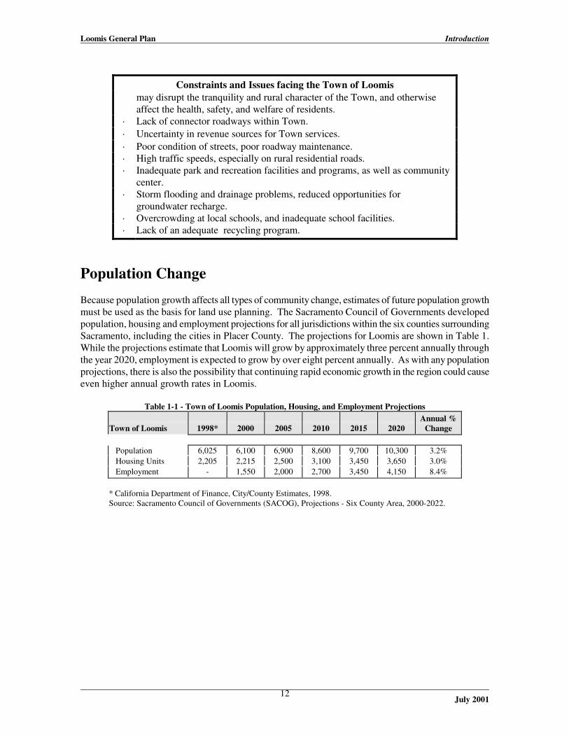
Population Change Because population growth affects all types of community change, estimates of future population growth must be used as the basis for land use planning. The Sacramento Council of Governments developed population, housing and employment projections for all jurisdictions within the six counties surrounding Sacramento, including the cities in Placer County. The projections for Loomis are shown in Table 1. While the projections estimate that Loomis will grow by approximately three percent annually through the year 2020, employment is expected to grow by over eight percent annually. As with any population projections, there is also the possibility that continuing rapid economic growth in the region could cause even higher annual growth rates in Loomis. Table 1-1 - Town of Loomis Population, Housing, and Employment Projections
Town of Loomis
1998*
2000
2005
2010
2015
2020
Annual %
Change Population 6,025 6,100 6,900 8,600 9,700 10,300 3.2% Housing Units 2,205 2,215 2,500 3,100 3,450 3,650 3.0% Employment - 1,550 2,000 2,700 3,450 4,150 8.4%
* California Department of Finance, City/County Estimates, 1998. Source: Sacramento Council of Governments (SACOG), Projections - Six County Area, 2000-2022.

Loomis General Plan Introduction
July 2001
13
The Future of Loomis The community’s vision for the future of Loomis is based primarily on: 1) retaining the small town aspects of its character through the revitalization of the downtown village and the expansion of family-oriented community facilities; and 2) maintaining the rural aspects of its character by continuing the pattern of progressively lower residential densities as distance increases from the downtown, thereby preserving low-intensity agricultural uses and natural open spaces. Town residents value the community’s distinct identity, featuring good public services and facilities, cultural activities, and agricultural heritage. The community workshop held on June 6, 1998, identified the following components as the participants’ vision for the community’s future. · The design and development of both residential and commercial parcels to reinforce the small
town character, rather than tending toward the more generic urbanization found in adjacent communities.
· The preservation of the remaining open space and rural character surrounding the community,
ensuring distinction between adjacent urban communities and rural Loomis. · The preservation of agricultural activities, including the farming of orchards and raising of
livestock. · The maintenance of primarily large lot, rural residential areas, but also providing some smaller
parcels for young families and seniors. · The avoidance of gated residential communities. · The revitalization of the downtown core with a consistent design theme, pedestrian amenities
(e.g. benches, crosswalks, shade trees), façade improvements, and reuse of historical structures. · The development of a pedestrian-oriented downtown, with small retail boutiques, restaurants and
sidewalk cafés, and a Town center complex for government offices and community events. · The development of a “transportation center” at a renovated train station and plaza at Horseshoe
Bar and Taylor Road in the downtown. · Acceleration of the rehabilitation and reuse of historical fruit sheds and older residences for retail
and office space in the downtown core. · The expansion of parking facilities and improvement of circulation patterns in the downtown
core. · The expansion of economic development and tourist activities in the downtown to increase Town
revenues. · The expansion of local theater and arts activities. · The design of new commercial uses in “village” scale, focusing on the construction of historical
façades, minimization of signage, and planting of street trees and landscaping.

Loomis General Plan Introduction
July 2001
14
· The improvement of areas considered “gateways” to the community, particularly the design and facades of areas adjacent to the Raley’s shopping center.
· The creation of sustainable Town policies, focusing equally on the consideration of
environmental, social and economic impacts of development. · The preservation of meandering rural roads, and the reduction of traffic speeds in rural
residential areas. · The development of an alternate through-road for commuter traffic from Rocklin to reduce
through-traffic volumes on Town roadways. · The improvement of local street connections, better road maintenance and repair, and improved
railroad grade crossings. · Increased street trees and landscaping throughout the community. · Cooperation with Placer County Transit to improve local and regional public transit services. · The use of landscaping and berms along I-80 to muffle noise, rather than sound walls. · The expansion of multi-use bicycle, equestrian and hiking trails throughout the community and
surrounding open lands, and support of a trail from Loomis to Folsom Lake. · The expansion of on-street bicycle lanes and pedestrian sidewalks in non-residential areas. · The preservation of creek corridors, open space areas, natural features, and wildlife habitat,
which in turn contributes to the retention of the rural community. · The expansion of parks and recreation facilities, including a downtown core park and bigger
swimming pool. · The expansion of family-oriented community and recreation programs, housed within a multi-use
community center. · The improvement of the local political process through better noticing of meetings and activities,
and stronger implementation measures in the General Plan. · The expansion and modernization of local school facilities. · The creation of a Town of Loomis Police Department, rather than contracting with the County
Sheriff’s Department. · The improvement of groundwater quality through the control of septic system leakage and well
pollution.
Loomis General Plan The Role of the General Plan
July 2001
15
II. The Role of the General Plan This chapter reviews the legal requirements for the General Plan, its organization, and the relationship of the local planning process in Loomis to the growth of the Sacramento region.
Legal Requirements for General Plans Local planning is based on the concept of “police power,” granted to cities and counties by the California Constitution. Police power is the authority to regulate the use of private property to promote the health, safety and welfare of the general public. The activities of land use planning, zoning, subdivision regulation, and the regulation of building and construction activities are all ways in which communities exercise their police power. California planning laws shape the exercise of local powers by requiring each city and county to prepare and adopt a “comprehensive, long-term General Plan for the physical development of the county or city.” (Government Code 65300). In some ways, the community’s General Plan functions as its “constitution” for development, providing guidance for local decisions about community growth. A General Plan should express the community’s goals for the future distribution and character of land uses and development, both public and private. California law (Government Code Section 65302) requires that the General Plan include a statement of policies for each of the following topics or “elements:” · Land use, designating the general distribution and intensity of land uses, including housing,
business, industry, open space, education, public buildings, and others. · Circulation, identifying the general location and nature of existing and proposed highways,
arterial and collector roadways, transit terminals, and other transportation facilities. · Housing, assessing the current and projected housing needs of all segments of the community
and identifying land to provide adequate housing to meet such needs. · Open Space, detailing techniques for preserving open space areas for natural resources, outdoor
recreation, public health and safety, and agricultural activities. · Conservation, addressing the conservation and use of natural and cultural resources, including
wetlands, forests, rivers, archeological remnants, and historic structures. · Noise, identifying and appraising the noise sources within the community and developing ways
to mitigate such nuisances. · Safety, establishing policies to protect the community from risks associated with seismic,
geologic, flood, and fire hazards. A General Plan may include additional, optional topics as necessary to address all local issues relevant to the physical development of the community. The individual elements may be consolidated and reformatted as desired as long as all seven topical areas are addressed in the General Plan.

Loomis General Plan The Role of the General Plan
July 2001
16
The plan should be comprehensive, both covering the local jurisdiction’s entire planning area and addressing the broad range of issues facing the community, including physical, social, aesthetic and economic concerns. The General Plan must also be internally consistent, with no policy conflicts between any of the elements. Finally, the General Plan must be a long-term document, establishing development policies to serve as the basis for day-to-day decision making within an approximate 20-year time frame.
Use of the General Plan The General Plan is intended to provide guidance in a wide variety of important decisions by the Town’s elected and appointed officials, and its staff. California law requires that all provisions of the Zoning Ordinance be consistent with the General Plan, and that no subdivision be approved unless it is consistent with the General Plan. State law also requires that all municipal decisions on capital improvements planning and budgeting be preceded by a review of their conformity with the General Plan. The goals, policies, and objectives of the General Plan will be used as criteria for evaluating the appropriateness of proposed Zoning Ordinance amendments and rezonings, subdivisions, capital improvement programs, and other Town decisions. The General Plan will also provide the basis for other “implementing” actions by the Town, which will include the adoption of amendments to the Town’s Zoning Ordinance and Zoning Map to bring them into consistency with the General Plan, and other specific actions that are described in the General Plan as “implementation measures.” Most of the following chapters of the General Plan provide goals, policies, and implementation measures. The Housing Element also provides “objectives.” The following explanation of goals, objectives, and policies is based on information provided by the General Plan Guidelines published by the California Governor’s Office of Planning and Research (OPR). Goals are general statements of what the Town wants to accomplish, toward which the General Plan, and its policies and implementation measures are directed. Goals are general expressions of community values and, therefore, may be abstract in nature. Therefore, goals may not be quantifiable or time-dependent. Objectives take the general direction expressed in a related goal and specify how the goal will be accomplished, both quantifiably, and within a specific time period. Objectives are found in this General Plan only in the Housing Element, because they are particularly effective in describing exactly how the community will respond to the housing mandates of State law, and the issues raised by the California Department of Housing and Community Development (HCD), in that agency’s review of local Housing Elements. Policies are specific statements that guide decision making, which indicate the Town’s commitment to a particular course of action. Some policies are written as “shalls”-- mandatory requirements that must be complied with--and others are written as “shoulds,” which express the community’s preferences, and signify “. . . a less rigid directive, to be honored in the absence of compelling or contravening considerations.” (General Plan Guidelines, p.15) Some of the policies of this General Plan also include standards. A standard is “A rule or measure establishing a level of quality or quantity that must be complied with or satisfied. Standards define the abstract terms of goals and policies with concrete specifications.” (General Plan Guidelines, p.16)
Loomis General Plan The Role of the General Plan
July 2001
17
The goals, objectives, policies, standards, and implementation measures of the Town of Loomis General Plan are collectively intended to assist the citizens of Loomis and their elected representatives in evolving the form and character of the community over time, to more closely match the vision for the community’s future expressed in Chapter I of this plan.
Organization & Content of the Loomis General Plan The Loomis General Plan is in two parts: a Technical Background Report, and this policy document. The background report presents detailed information on the environmental, social, and economic characteristics of Loomis that are relevant to the Town’s future, and which provided the basis for formulating General Plan policies. This policy document contains the “working” portions of the General Plan, to guide Town decision-makers and staff when making decisions regarding proposals for the development and use of public and private property, and the expenditure of Town funds on public facilities, services, infrastructure and other improvements. This policy document is deliberately brief, and should be used in conjunction with the background report when more detailed information about the Town is needed. This policy document is organized into the following sections: · Introduction – Loomis and its Future – includes a description of the Town of Loomis, a brief
history of its settlement and development, the opportunities and constraints facing future development in the Town, and the community’s vision for it’s future.
· The Role of the General Plan – a description of the legal requirements for a General Plan, the
plan’s context within regional planning efforts, and the organization and content of the Town of Loomis General Plan.
The following five elements contain issues, goals and policies for all seven required topics and six optional topics. · Community Development Element – includes Land Use (and the Land Use Diagram), the
Downtown Plan, Community Design and Character, Parks and Recreation, and Economic Development.
· Circulation Element – includes goals and policies related to the community’s circulation
system, and the various transportation modes available to, or needed within the community. · Housing Element - this is the only element of the General Plan that must be reviewed by the
State (the Department of Housing and Community Development (HCD)), and is subject to a specific update schedule established by State law. Therefore, the Housing Element has been reformatted to match the style of the other General Plan elements, but is not being updated at this time. Its update will follow the schedule required by the State.
· Public Facilities and Services Element – includes public facility, services, and municipal fiscal
policies.

Loomis General Plan The Role of the General Plan
July 2001
18
· Conservation of Resources Element – includes Natural Resources and Cultural Resources sections.
· Public Health & Safety Element – includes Safety and Noise sections.
Preparation of the Loomis General Plan The fact that the Town of Loomis General Plan reflects the preferences of the community for its future is a product of the extensive participation of Loomis citizens in its preparation. The public participation program for the General Plan update has included several key components: 1. An initial “visioning” workshop where approximately 100 Loomis residents met at Del Oro
School on a Saturday morning to consider the future of the community, and participate in a series of group exercises to generate ideas, issues and concerns to be considered in the update process;
2. A community preferences survey that was completed by 805 Loomis residents and business
owners; 3. Extensive work by a Council-appointed General Plan Steering Committee comprised of 10
volunteer residents. The Committee met 36 times over 18 months with Town staff and the Town’s consultants to review the former General Plan, update its policies where appropriate, and formulate additional proposed policies and the draft Land Use Diagram;
4. Public workshops for review of the draft plan prior to public hearings; and 5. Eleven public hearings on the draft General Plan before the Town Planning Commission and over
13 hearings before the Town Council.
Amendments to the General Plan The California Government Code allows municipalities to amend their General Plans up to four times per year, with no limitation on the number of individual changes that may occur within each of the four times. However, given the substantial effort, thought, and care taken by the community in the preparation of this comprehensive General Plan update, the Town intends to diligently carry out the plan as adopted, and not frequently consider changes to its policies and property designations. Instead, the Town intends that the General Plan undergo a thorough periodic review, including consideration of changes to individual property designations, at least once every five years. The following policies apply to the Town’s consideration of amendments proposed by private parties. Policies on General Plan Amendments 1. It is the policy of the Town to not consider subsequent individual property amendment requests
outside of the periodic review of the entire plan, unless the proposed amendments clearly offer community-wide public benefits.
2. Individual property General Plan amendments that are requested at times other than during a
periodic review by the Town will be considered at a Council meeting prior to formal Town review (i.e., environmental determination, complete staff review with the preparation of a staff report and recommendation, and public hearings before the Commission and Council). The purpose of this

Loomis General Plan The Role of the General Plan
July 2001
19
initial review will be for the Council to determine whether the proposed amendment complies with Policy 1 above, and whether the Council wishes to initiate the processing of the amendment.
3. If an individual property amendment request is approved by the Council for processing, the public
notice for hearings before the Planning Commission and Town Council to consider the amendments will be mailed to all Town property owners, at the expense of the applicant.
Long-Term Growth The provisions of this General Plan addressing growth and change are focused on the area within the current corporate boundary of the Town, and do not provide for any expansion beyond that boundary. This approach was followed for two reasons: the population and business growth projected for Loomis over the term of this plan can be accommodated through the additional subdivision, residential and non-residential development anticipated by this plan within the present incorporated area; and the Town’s current Sphere of Influence established by the Placer County Local Agency Formation Commission (LAFCO) is coterminous with the current Town boundary. The Town’s Sphere of Influence is a key component of future growth decisions. California law provides that a city may not annex property unless it is included within the municipality’s Sphere of Influence. It is the responsibility of the Local Agency Formation Commission to establish a sphere for each incorporated community and special district within its county, based on input from each. The Sphere of Influence is intended to identify areas where a city definitively plans to annex property for growth within a 10- to 20-year time frame, and where the city has (or will have) the capacity to provide all necessary public services, infrastructure, and other public facilities as growth extends into the area of the sphere. Given the need to complete this General Plan update within a reasonable time, and the additional time and effort that would be required for the analysis necessary to justify a change in the Town’s sphere to the Local Agency Formation Commission, the Town has decided to explore the desirability of a Sphere of Influence expansion through a separate study after the completion of this General Plan update. Implementation Measures 1. Within two years, or as soon as possible after the adoption of this General Plan, the Town will
prepare a Sphere of Influence Study in compliance with LAFCO requirements, to evaluate areas surrounding the community that may be appropriate for annexation, and will amend the General Plan to provide land use designations, and policies for public facilities, services, and infrastructure as necessary to reflect the Town’s new Sphere of Influence and desired growth pattern.

Loomis General Plan The Role of the General Plan
July 2001
20
Regional Coordination As a community grows within its larger region, local changes have a greater potential over time to affect other communities and the region as a whole. Therefore, each jurisdiction carries a responsibility to coordinate its General Plan with regional planning efforts. The General Plan must be coordinated with other local government agencies to ensure consistent planning decisions, as well as the attainment of regional circulation, environmental and housing goals. The General Plan must also coordinate with special districts providing public services to community residents to ensure the effective and efficient provision of such services based on similar development and population projections. The regional agencies whose planning policies may affect the Town of Loomis are shown in Table 2, and in Figure 2-1. Among the many separate tasks required to complete this General Plan were the review of the General Plans of neighboring jurisdictions, particularly including the City of Rocklin, and Placer County. The Town of Loomis is committed to coordinating and working with the other jurisdictions in the region to address the many planning issues that cross political boundaries to affect cities, citizens, infrastructure, and environmental resources. Table 2-1 - Regional Planning Considerations
Agency
Planning Responsibilities Loomis Fire Protection District
Locate fire protection facilities and provide emergency medical, fire suppression and protection services as needed to serve developed and undeveloped areas.
Loomis Union School District Plan for and provide school facilities as needed to accommodate population growth.
Penryn Fire District Locate fire protection facilities and provide emergency medical, fire suppression and protection services as needed to serve developed and undeveloped areas.
Penryn School District Plan for and provide school facilities as needed to accommodate population growth.
Placer County Air Pollution Control District
Responsible for reducing and maintaining regional air pollution levels to within federal and state standards; prepares the Air Quality Management Plan (AQMP - federal) and Air Quality Attainment Plan (AQAP - state).
Placer County Environmental Health Division
Responsible for the treatment, storage and disposal of hazardous wastes, as well as the siting and management of hazardous waste facilities; prepares the Placer County Hazardous Waste Management Plan; reviews and approves wells and on-site sewage disposal systems.
Placer County Flood Control and Water Conservation District
Responsible for the conservation and development of water resources, and control and management of drainage, storm, flood and other waters; prepares the Dry Creek Watershed Flood Control Plan, Stormwater Management Plan, and Placer County Flood Hazard Mitigation Plan.
Placer County Open Space Implementation Project
Responsible for developing economically-viable implementation programs to enable Placer County to preserve natural resources and habitats; prepares the Natural Communities Conservation Plan.
Placer County Solid Waste Division
Responsible for solid waste reduction and collection, as well as the siting and management of solid waste facilities in Placer County; prepares the Placer County Integrated Waste Management Plan.
Placer County Transportation Planning Agency
Responsible for the planning of a comprehensive, multi-modal transportation system in the Placer County region; prepares the Regional Transportation Plan (RTP).
Placer County Water Agency Responsible for the treatment, storage and distribution of potable water supplies in Placer County; prepares the Treated Water Supply Master Plan.
Placer Union High School District
Plan for and provide school facilities as needed to accommodate population growth.
Sacramento Council of Governments (SACOG)
Advisory agency on issues of inter-jurisdictional concern in El Dorado, Placer, Sacramento, Sutter, Yolo and Yuba counties; serves as the Metropolitan Planning Organization for member counties; primarily addresses issues relating to land use, circulation and air quality; prepares the Metropolitan Transportation Plan (MTP).

Loomis General Plan The Role of the General Plan
July 2001
21
Agency
Planning Responsibilities
Sierra Economic Development District (SEDD) and Sierra Planning Organization (SPO)
Regional advisory agency on issues of inter-jurisdictional concern in the Sierra Nevada region; provides regional demographic and economic information, and mandated housing allocations; prepares the Overall Economic Development Plan.
South Placer County Fire District
Locate fire protection facilities and provide emergency medical, fire suppression and protection services as needed to serve developed and undeveloped areas.
South Placer Municipal Utility District (SPMUD)
Responsible for sewer collection services to Loomis, Rocklin and Dry Creek Basin; prepares the SPMUD Sewer Master Plan, and participates in the preparation of the Roseville Regional Wastewater Treatment Service Area Master Plan.
Source: Town of Loomis, General Plan Update Technical Background Report – August 1998.

Loomis General Plan The Role of the General Plan
July 2001
22

Loomis General Plan Community Development - Land Use
July 2001
23
III. Land Use and Community Development
Land Use The Town of Loomis is characterized by a village-style core containing a historical, small-scale downtown, surrounded by medium-density housing and some light industry, with much lower density rural residential areas beyond. The land use goals and policies of the General Plan are all oriented toward maintaining this historical arrangement of land uses, because the Town recognizes the importance of the land use pattern in determining community character. Higher-intensity uses are intended to be concentrated adjacent to the downtown, along Taylor Road, and adjacent to Interstate 80 (I-80), with the land uses in surrounding areas becoming progressively less intense (and with lower residential densities) as the distance from the “core” increases. This arrangement of land uses within the Town is known in Loomis as the “core concept.” This section on land use describes how the General Plan divides Loomis into areas designated for different types of land use, reviews the areas where the land use designations have been changed from the 1987 General Plan, and lists the Town’s goals and policies for each type of land use. A. Land Use Designations Given that the Land Use Element is intended to designate the general distribution and intensity of land uses, including housing, business, industry, open space, education, public buildings, and others, the Land Use Diagram (Figure 3-1) divides Loomis into a series of residential and non-residential land use designations. These different land use designations identify the locations in the Town where specific types of land uses may occur. While the land use designations are implemented (carried out on a day-to-day basis) by the specific rules provided for each zoning district in the Zoning Ordinance, the General Plan provides the overall parameters of density and intensity, and a description of the general types of land uses appropriate in each designation. The land use designations used in this General Plan are derived from those in the Town’s 1987 General Plan, as amended, and the 1992 Town Center Master Plan, with some changes. The following descriptions of land use designations use the terms “density” and “intensity.” Density refers to the number of residential units normally allowed per gross acre of land (prior to dedications for streets and other improvements). The density range listed for each land use designation is its “base density.” On any particular property, the maximum base density may be exceeded if a proposed development receives the density bonus required by State law for affordable housing projects, or if the property qualifies for, and is developed with a second unit (see the General Plan policies for second residential units on page 36). The “intensity” of a land use is expressed in two ways – the type of land use itself, and building mass– both of which are described broadly in the description of each land use designation. Both are also regulated specifically by the Town’s Zoning Ordinance. The types of land uses allowed in each designation are described in general terms, because the Zoning Ordinance is intended to provide detailed lists of the specific allowable land uses within the general categories provided here. In all cases where this discussion speaks of the primary land uses that are appropriate in each designation, it is expected that the Zoning Ordinance may also allow additional land uses that are related to the primary uses and compatible with them.

Loomis General Plan Community Development - Land Use
July 2001
24
Residential Designations
Residential Agricultural. Almost 2,500 acres of the nearly 4,300 acres in Loomis are designated Residential Agricultural, in two primary areas: the western-most portions of the Town, north of I-80, and approximately 80 percent of the land area in the Town south of I-80. This land use designation is key in maintaining the rural character of Loomis, and is appropriate for agricultural uses such as orchards, nurseries and vineyards, cattle grazing, and very low density residential uses. Proposed development and agricultural uses should maintain existing natural vegetation and topography to the maximum extent feasible.
The maximum density in this designation is 4.6 acres per dwelling unit, and 4.6 acres is also the minimum parcel size for proposed subdivisions. Building heights are limited to two stories or 35 feet, and structural development shall not exceed 20 percent of lot coverage. (The Zoning Ordinance may provide for greater coverage on existing legal nonconforming parcels that are significantly smaller than the 4.6-acre minimum.)
Residential Estate. Approximately 475 acres are designated in the Residential Estate land use designation, located in four separate areas: at the northeastern edge of Town; along both sides of Bankhead Road from just north of I-80 to north of Saunders Avenue; south of Brace Road and southeasterly of I-80; and immediately northeast of the intersection of Barton and Rocklin Roads. Like the Rural Agricultural land use designation, appropriate land uses include agricultural uses such as orchards and vineyards, cattle grazing, and very low density residential uses. Proposed development and agricultural uses should maintain existing natural vegetation and topography to the maximum extent feasible.
The maximum density in this designation is 2.3 acres per dwelling unit, and 2.3 acres is also the minimum parcel size for proposed subdivisions. Building heights are limited to two stories or 35 feet, and structural development shall not exceed 20 percent of lot coverage. (The Zoning Ordinance may provide for greater coverage on existing legal nonconforming parcels that are significantly smaller than the 2.3-acre minimum.)
Rural Residential. The Rural Residential designation comprises approximately 278 acres, and is located in five areas: along King Road around its intersection with Bankhead; in a larger area along Saunders Road northwesterly of the railroad right-of-way; in a small area on the south side of Brace Road a short distance east of I-80; the St. Francis Woods subdivision south of Rocklin Road at the western Town Boundary; and at the north central area of the Town along Humphrey Road. Agricultural uses are also appropriate on these parcels, although the keeping of large animals should occur only on parcels of one acre or larger. As in the other lowest-density residential designations, proposed development and agricultural uses should maintain existing natural vegetation and topography to the maximum extent feasible.
Residential uses are limited to a maximum density of one dwelling unit per acre, and one acre is also the minimum parcel size for proposed subdivisions. Building heights are limited to two stories or 35 feet, and structural development shall not exceed 20 percent of lot coverage.

Loomis General Plan Community Development - Land Use
July 2001
25
Residential - Low Density. This land use designation is applied to 12 acres in two areas: an existing, built-out single-family neighborhood along Mareta Lane, and to several larger parcels on the north side of King Road between Taylor Road and I-80. This designation is intended for single-family homes, and related, compatible uses.
Residential uses are limited to a maximum density of one dwelling unit per one-half acre, and one-half acre is also the minimum parcel size for proposed subdivisions. Building heights are limited to two stories or 35 feet, and structural development shall not exceed 40 percent of lot coverage.
Residential - Medium Density. This single-family residential land use designation is applied to approximately 330 acres, including: the Sunrise Loomis neighborhood and adjacent areas on the west side of Humphrey Road and south of King Road; two areas on the north and south sides of King Road between Taylor Road and I-80; and an area on the north and south sides of Brace Road between Sierra College Boulevard and I-80.
This land use designation may accommodate residential use at densities ranging from two to six dwelling units per acre, with the appropriate minimum parcel size for proposed subdivisions determined by the Zoning Ordinance. Building heights are limited to two stories or 30 feet, and structural development shall not exceed 50 percent of lot coverage.
Residential - Medium-High Density. These residential areas encompass approximately 94 acres in two locations adjacent to the downtown core, and are intended to accommodate smaller lot single-family residential development, and lower density multi-family development including duplexes.
This land use designation may accommodate residential use at densities ranging from six to 10 dwelling units per acre, with the appropriate minimum parcel size for proposed subdivisions determined by the Zoning Ordinance. Building heights are limited to two stories or 30 feet, and structural development shall not exceed 60 percent of lot coverage.
Residential - High Density. This multi-family residential designation is applied to a single area on the south side of Brace Road, east of Sierra College Boulevard. Residential use may be approved at densities ranging from 10 to 15 dwelling units per acre, with the appropriate minimum parcel size for proposed subdivisions determined by the Zoning Ordinance. Building heights are limited to two stories or 30 feet, and structural development shall not exceed 60 percent of lot coverage.
Commercial and Other Designations
Office and Professional. The Office and Professional designation encompasses approximately 24 acres in three locations: on the south side of King Road west of Swetzer Rd.; on the north side of King Road east of Taylor Road; and on the north and south sides of King Road at I-80. This designation is intended for general business offices, professional and medical offices. Real estate and financial offices, and other similar uses may also be allowed. Residential uses may be allowed as part of mixed use structures. Building heights are generally limited to two stories or 30 feet, and structural development shall not exceed 35 percent of lot coverage. The density of residential uses in mixed use projects may range from two-to-10 dwellings per acre.

Loomis General Plan Community Development - Land Use
July 2001
26
General Commercial. This designation is intended mainly for retail and service commercial uses located outside of the downtown core, that primarily serve local residents and businesses. Areas within this land use designation may also accommodate residential uses as part of mixed-use structures or site development, where provided by the policies for specific areas beginning on page 39 (Section G. of this Land Use Element). The areas within this land use designation are located along Taylor Road, on Sierra College Boulevard extending from I-80 to Taylor Road, and along I-80 from Horseshoe Bar Road to King Road. Building heights are limited to two stories or 35 feet, and structural development shall not exceed a lot coverage of 50 percent. The density of residential uses may range from two-to-10 dwellings per acre, where allowed by the policies for specific areas.
Town Center Commercial. This designation is applied to approximately 39 acres along Taylor and Horseshoe Bar Roads to the area identified as the “Downtown Core” by the Loomis Town Center Master Plan prepared in 1992. According to the master plan, “The Downtown Core describes an area where a variety of higher intensity uses are encouraged . . .” “Commercial uses along Taylor Road within the Downtown Core should evolve into specialty retail shopping district that will serve both residents and visitors. The Core should capitalize on its historic character, its existing fresh produce activities, its potential commuter rail stop, and its proximity to large numbers of residents and employees.” The Town Center Commercial designation is intended to accommodate a mixture of land uses, with primarily retail commercial and office uses on the ground floors of commercial structures, and residential units allowed on second or third floors. The density of these mixed-use residential units should not exceed 15 dwelling units per acre. Building heights are limited to three stories or 35 feet. Site coverage may range from 35 percent to a maximum of 100 percent, and the allowable floor area ratio (FAR) may range from 0.35 to 1.60, with a FAR greater than 0.50 allowed only where parking is approved by the Town to be either in parking structures that do not detract from the intended pedestrian orientation of the Downtown Core, or in public parking lots or other approved off-site locations.
Tourist/Destination Commercial. This is one of three new land use designations developed for this General Plan update, and it is applied to approximately 117 contiguous acres in multiple ownerships along the southeasterly side of I-80 from Brace Road on the southwest to the Town boundary on the northeast, and bounded by Secret Ravine on the southeast. This land use designation is intended to accommodate a mixture of office/business park, retail commercial, lodging, conference center and other traveler-serving uses, local-serving entertainment uses, and residential uses as part of mixed-use structures.
Building heights are limited to three stories, not to exceed 45 feet, provided that any height over 35 feet shall require Fire Department approval. Within this area, site coverage may range from 35 percent to a maximum of 50 percent. The density of residential uses within mixed-use projects may range from two to 10 dwellings per acre.
Business Park. This is also a new land use designation developed for this General Plan update, and it is applied to approximately 35 acres in single ownership along the northerly edge of the Union Pacific Railroad right-of-way, northeasterly of Sierra College Boulevard. This site will eventually be bounded along its southeasterly edge by the extension of Swetzer Road to Sierra College Boulevard. The property along the extension of Swetzer Road is also subject to special policies which define its development potential, and provide standards for the design of potential development projects. These policies can be found on page 39.

Loomis General Plan Community Development - Land Use
July 2001
27
As applied to specific properties by this General Plan and as may be applied to additional properties through later amendments, this land use designation is intended for “headquarters” office-type and high technology uses in campus-like settings (buildings of similar or compatible architecture with shared circulation and parking, with substantial setbacks from streets and other property boundaries) with extensive landscaping throughout. Building heights are limited to two stories or 30 feet. Within this area, site coverage may range from 35 percent to a maximum of 50 percent.
Limited Industrial. This is another new land use designation developed for this General Plan update, and is applied to approximately 36 acres along the west side of Swetzer Road north of King Road. The purpose of the designation is to provide locations for light industrial uses that can operate near residential uses without adversely affecting residents. Appropriate light industrial uses will:
· Have no outdoor activity or storage areas adjacent to residential uses, other than employee
and client/customer parking, and screened storage areas with no noise-producing activities; · Locate no loading or delivery areas adjacent to residential uses; and · Operate only during normal weekday business hours unless site planning provides for
buffer areas adjacent to residential uses.
Most of the parcels within this designation are presently either built-out, or occupied by storage yards. This designation is intended to provide for the evolution of the area over time, to industrial uses that are more compatible with the adjacent residential area.
Building heights are limited to two stories up to 30 feet, except that one story or 25 feet is required within 100 feet of an adjacent residential zoning district. Site coverage may range from 35 percent for office-type uses to a maximum of 40 percent for warehouse-type uses.
Light Industry. The Light Industry land use designation is applied to approximately 110 acres along both sides of Rippy Road, from King Road to the north Town boundary. This designation is intended for the manufacturing, production, storage, or sale of consumer goods and services, and for heavy commercial uses that involve outdoor activity or storage areas. Research and development offices, start-up businesses, warehouses, manufacturing plants, and other similar types of uses and supporting uses may be allowed. This designation is not intended for heavy industrial uses, such as chemical plants. Building heights are limited to two stories or 35 feet, and site coverage shall not exceed 50 percent
Public-Quasi Public. The Public-Quasi Public land use designation is applied to properties owned by the Town and other public agencies (including school districts), which include a range of uses such as libraries, parks, schools, fire stations, emergency medical service facilities, etc. Building heights are limited to two stories or 30 feet, and site coverage may range from 35 percent to a maximum of 50 percent.

Loomis General Plan Community Development - Land Use
July 2001
28
Table 3-1 - General Plan Land Use Categories, Maximum Density And Intensity (1)
Building Intensity
Land Use Category
Maximum Residential Density (2)
Maximum Height
Maximum Site Coverage
Maximum Floor Area
Ratio (FAR) Residential Agricultural
1 d.u./4.6 acre
2 stories/35 ft.
20%
N.A.
Residential Estate
1 d.u./2.3 acre
2 stories/35 ft.
20%
N.A.
Rural Residential
1 d.u./acre
2 stories/35 ft.
20%
N.A.
Residential - Low Density
2 d.u./acre
2 stories/35 ft.
25%
N.A.
Residential - Medium Density
2 - 6 d.u./acre
2 stories/30 ft.
35%
N.A.
Residential - Medium High Density
6 - 10 d.u./acre
2 stories/30 ft.
40%
N.A.
Residential - High Density
10 - 15 d.u./acre
2 stories/30 ft.
50%
N.A.
Office & Professional
2 - 10 d.u./acre in mixed-use projects
2 stories/30 ft.
35 - 60%
N.A.
General Commercial
2 - 10 d.u./acre, as allowed by specific area policies
2 stories/35 ft.
25 - 50%
N.A.
Town Center Commercial
15 d.u./acre in mixed use projects
3 stories/35 ft.
35 - 60%
0.25 - 1.60
Tourist/Destination Commercial
2 - 10 d.u./acre in mixed-use projects
3 stories/45 ft. (3)
25 - 40%
N.A.
Business Park
N.A.
2 stories/30 ft.
35 - 60%
N.A.
Limited Industrial
N.A.
2 stories/30 ft.
50%
N.A.
Light Industry
N.A.
2 stories/35 ft.
50%
N.A.
Public/Quasi-Public
N.A.
2 stories/30 ft.
35 - 50%
N.A.
Notes: (1) See the narrative descriptions of each land use category beginning on page 21 for exceptions and additional
standards. (2) Residential density is expressed in dwelling units (d.u.) per acre. (3) Building height over 35 feet in the Tourist/Destination Commercial land use category requires Fire
Department approval.

Loomis General Plan Community Development - Land Use
July 2001
29
AFTER COPYING, REPLACE THIS PAGE WITH: LAND USE DIAGRAM - FIGURE 3-1

Loomis General Plan Community Development - Land Use
July 2001
30

Loomis General Plan Community Development - Land Use
July 2001
31
B. Areas of Land Use Change After lengthy review of the land use pattern proposed for Loomis by the 1987 General Plan and 1992 Town Center Master Plan, and the various goals for the future of the Town in this and other portions of the General Plan, the General Plan Steering Committee, Planning Commission, Town staff, and the Town’s consultants recommended several changes to the land use designations of the 1987 General Plan. The following changes have been enacted by the Town Council as part of this General Plan update, are shown on Figure 3-2, and are also incorporated into the Land Use Diagram (Figure 3-1).
Changes in residential density. Residential density has been increased in six areas. Four of the six involved changing the land use designation from Residential-Agricultural (4.6 acres per dwelling unit) to Residential Estate (2.3 acres per dwelling unit). These areas are:
· North of King Road on both sides of Barker Road; · On both sides of Bankhead/Barker Road and extending south from King Road to the Town
boundary; · Southeast of I-80 from Secret Ravine creek to approximately 500 feet south of Brace Road;
and · Northwest of the intersection of Rocklin and Barton Roads.
Two additional areas have been changed to increase residential density:
· A parcel on the south side of Taylor Road at the northeast Town boundary has been
changed from Residential Estate (2.3 acres per dwelling unit) to Residential Medium Density (2 to 6 dwelling units per acre); and
· A parcel on the west side of Humphrey Road between the north Town boundary and King Road, immediately south of the new elementary school site.
Residential density has been decreased from Residential - Medium High Density (6 to 8 dwelling units per acre) to Residential - Medium Density (2 to 6 units per acre) on a triangular parcel abutting I-80 between Horseshoe Bar Road and King Road, and south of the end of Day Avenue.
The residential designation and density limitations have also been changed in the subdivision on Mareta Lane (from Rural Residential, one acre per unit, to Residential Low Density, one-half acre per unit). However, this change simply recognizes the existing density of the built-out subdivision, and creates no additional opportunity for subdivision.
Residential to commercial. The following areas have been changed from residential to commercial.
· Two parcels along the southerly side of Taylor Road northeasterly of Sierra College
Boulevard have been changed from residential designations to General Commercial. · A parcel at the northwest corner of King Road and I-80 has been changed from Residential
Estate to Office and Professional. · A parcel near the northeasterly Town boundary on the southerly side of Taylor Road has
been changed from Residential Estate to General Commercial. · A 35-acre parcel along the north edge of the railroad right-of-way northeast of Sierra
College Boulevard has been changed from Residential Estate to Business Park.
Loomis General Plan Community Development - Land Use
July 2001
32
· Several parcels encompassing approximately 117 acres have been changed from the former General Plan’s Residential Rural Estate designation to the new Tourist/Destination Commercial designation.
Modifications to commercial designations. Commercial land use designations have been changed in five locations. The Shopping Center designation of the former General Plan has been changed to General Commercial at the southeast corner of Brace Road and Sierra College Boulevard, and on Horseshoe Bar Road and I-80 (the Raley’s center). The Office/Professional designation at the northeast corner of Brace Road (extending north to Taylor) has also been changed to General Commercial. These changes and the elimination of the Shopping Center designation are intended to provide for greater flexibility in the range of retail and office uses that may be allowed in these locations.
The property on the south side of King Road at I-80 has been changed from Neighborhood Commercial to Office/Professional, and the Neighborhood Commercial designation of the former General Plan has been eliminated. The Neighborhood Commercial designation was applied only to the single site, and the desire of the Town to reinforce the core concept and not provide for commercial uses outside of the core have made the designation unnecessary. The General Commercial designation also provides greater flexibility in the range of possible land uses.
The property abutting the Raley’s center at its north edge has been changed from the Planned Development designation of the former General Plan to General Commercial, and the Planned Development designation has been eliminated. Like the Neighborhood Commercial designation, Planned Development was applied to a single site. It was intended to ensure that proposed development would include a mixture of uses, with new, higher-density residential uses providing a buffer between the commercial development adjacent to I-80 and the existing single-family residential areas to the north. This General Plan has retained those objectives through specific policy language that has been applied to the site.
Finally, property on the south side of King Road west of Webb has been changed from General Commercial to Office/Professional, to reflect both existing approved development and the desired future land uses.
Other changes. A new Limited Industrial designation has been included in this General Plan, and property on the west side of Swetzer Road north of King Road has been changed from Light Industry to Limited Industrial. This is intended to provide for a transition over time to industrial uses that will be more compatible with the residential area to the west than the existing industrial uses.

Loomis General Plan Community Development - Land Use
July 2001
33
INSERT FIGURE 3-2 - AREAS OF CHANGE

Loomis General Plan Community Development - Land Use
July 2001
34

Loomis General Plan Community Development - Land Use
July 2001
35
C. Land Use Issues and Goals Issues · Increased urbanization in adjacent communities is threatening to encroach upon the open space
and agricultural areas in and surrounding Loomis. · Loomis should support the expansion of bicycle, equestrian and hiking trail systems both within
and surrounding the Town of Loomis. · Development pressures suggest that Loomis consider rezoning some of its
agricultural/residential land to increase land and infrastructure efficiency. However, residents have expressed their preference for the retention of large lot, rural residential parcels.
· Size restrictions need to be placed on secondary residential units allowed on agricultural and
rural residential lots in Loomis. · Newer single and multi-family residential projects lack design, architecture and scale
appropriate for the small, rural Town of Loomis. · Loomis is feeling development pressure for intensification of land uses and build-out of
underutilized parcels from surrounding urbanization. · Sierra College Boulevard is an important regional circulation route, and may be appropriate for
more intensive land uses. However, Town residents have indicated strong support for concentration of more intensive land uses in the traditional downtown core area.
· The lack of street trees and landscaping in some commercial areas detracts from the Town’s
aesthetic quality. · Residents find some of the Town’s existing commercial signage undesirable, particularly along
I-80. · Residents frequently shop outside of Town limits due to limited retail product availability in
Loomis, thereby creating significant retail sales leakage. · Many residents work outside of Town limits due to limited employment opportunities in Loomis. · The increased public services and facilities desired by existing Town residents are dependant on
property and sales tax revenues, which would increase with additional development of commercial and industrial uses.
· Residents of Loomis would like to accelerate the redevelopment of the downtown. Goals 1. To preserve, maintain, and enhance creeks and riparian areas for both their aesthetic and wildlife
habitat values. 2. To protect groundwater and surface water quality.
Loomis General Plan Community Development - Land Use
July 2001
36
3. To protect oak woodlands and significant stands of native trees. 4. To protect major landscape features within Loomis, including significant topography and rock
outcroppings, open meadows and grazing areas. 5. To maintain the rural character of Loomis in new residential developments by emphasizing rural
character, quality, and livability in their design, and the provision of necessary services and facilities.
6. To focus more intensive land uses near the downtown and freeway interchange, while
maintaining the predominantly agricultural/rural character of Loomis outside the core area. 7. To attract new development and land uses that provide jobs to Town residents, provided that
those uses are consistent with the Town’s character. 8. To designate adequate land to accommodate new commercial and industrial development that is
consistent with the Town’s character. 9. To improve the Town’s commercial base to increase municipal revenues, and provide a wider
range of goods and services for local residents, in addition to encouraging some commercial uses near the freeway and in the downtown that can attract or serve patrons from outside the community.
D. Agricultural and Open Space Land Use Policies 1. Loomis shall allow property owners the "right-to-farm" their parcels through the protection and
operation of agricultural land uses. 2. Equestrian activities shall be protected by considering the effect that future density and design of
residential development has in enhancing or inhibiting these activities. 3. Loomis shall use zoning designations to protect properties used for agricultural operations from
encroachment by urban development. 4. Loomis shall provide for the use of the Williamson Act agricultural preserve program to allow
land owners the property tax advantages of a long-term commitment to agricultural use. E. Residential Land Use Policies General Policies The following policies apply to all residential designations and land uses. The following section on page 36 provides policies regarding some specific residential land uses. 1. Loomis shall maintain a balance between residential building density and the capacity of the
circulation system, schools, fire and police services, and other public service facilities.
Loomis General Plan Community Development - Land Use
July 2001
37
2. New residential development shall be required to bear the full financial burden for new public service capital improvements required to serve the residents of the development, through impact fees, environmental mitigation fees, and other appropriate measures.
3. New development should not create undue demand on schools, roads, or adversely affect the
quality of life in adjoining neighborhoods. 4. Loomis shall encourage the revitalization and rehabilitation of deteriorating residential areas
throughout the Town. 5. Loomis shall require the design of future residential projects to emphasize character, quality,
livability, and the provision of all necessary services and facilities to insure their permanent attractiveness.
6. The Town may approve the clustering of development, with no increase in net density, on sites
where clustering is feasible, and necessary to protect sensitive natural features (such as creeks, native trees, rock outcrops) and avoid potentially hazardous areas (such as steep slopes, flood zones, and unstable soils). The Zoning Ordinance shall provide a Planned Development (PD) procedure that may be used in these cases. The option of clustering is offered by the Town as a means of preserving environmental and scenic resources, and shall not be used as a method for achieving the maximum density allowed by the General Plan. The priority for rural residential subdivision design must be the preservation of environmental resources and rural character.
7. When subdivision is proposed within an existing residential neighborhood, and the General Plan
and/or Zoning Ordinance allow new parcels smaller than those existing around the parcel(s) to be divided, the proposed parcels should be increased in size consistent with the nearby residential lots fronting upon the same street.
8. Town approval of parcels proposed in any new subdivision will be based on all appropriate
environmental and compatibility factors, and all applicable Town policies and regulations. Therefore, the maximum densities provided by the General Plan and the minimum parcel sizes of the Zoning Ordinance may be decreased (in the case of density) or increased (in the case of parcel size) through the subdivision review and approval process as determined by the Town to be necessary. The Town does not guarantee that any individual project will be able to achieve the maximum densities as designated in the General Plan, or the minimum parcel sizes provided by the Zoning Ordinance.
8. Loomis shall promote the full utilization of land already committed to urban development before
utilities and public services are extended to areas without existing urban infrastructure. 9. Outside of the core area, Loomis shall promote a rural residential environment consisting
primarily of single family homes. 10. Loomis shall encourage the provision of adequate housing opportunities for people on fixed or
limited incomes, with emphasis on senior citizen housing. 11. Multi-family residential areas shall be designed to be compatible with nearby single family
residential neighborhoods in terms of height and massing, and overall design. Multi-family residential development shall not be permitted on arterials serving as entryways to the Town unless substantial setbacks and landscaping are provided.

Loomis General Plan Community Development - Land Use
July 2001
38
12. Proposed development shall be planned and designed to preserve and enhance significant natural
features (e.g. creeks, wetlands, native trees, rock outcrops, wildlife habitat), and retain the existing topography, to the greatest extent practical.
13. Loomis shall evaluate all new residential subdivisions and other significant development
proposals for consistency with the Town's design standards, with the objectives of maintaining a small, neighborly, rural community, reflective of the Town's heritage. Proposed projects that are inconsistent with the Town's design guidelines shall be denied, or be revised to be consistent.
14. Loomis shall encourage the retention and enhancement of natural vegetation along major
roadways in new developments as a tool for mitigating noise impacts and providing scenic open spaces.
15. New residential development near the freeway shall consider alternative noise mitigation
measures and avoid the construction of artificial freeway sound walls. 16. Loomis shall prohibit the development of gated residential communities. 17. Loomis will monitor the rate and type of residential development within the Town in relation to
commercial and industrial revenue-producing development, and may enact measures to ensure balance between residential and non-residential development so that excessive residential growth does not adversely affect Town finances.
18. All new development in Loomis shall conform to the land use map, land use categories and
development intensities set forth in this General Plan. Policies for Specific Residential Land Use Issues The policies of this section apply to the following specific residential development issues.
Second Residential Units
State law, and past Town policies and regulations have provided the possibility for residential parcels of sufficient size to be developed with a second residential unit in addition to the primary dwelling normally allowed. This possibility raises important land use policy issues for the Town, because an uncontrolled proliferation of second units could change the single-family residential character of neighborhoods and rural residential areas, and increase traffic on roads that were planned in anticipation of lower densities. Inappropriately designed and sited second units in the rural areas of the Town can also disrupt neighbors’ privacy, and impair the rural character of those areas. Therefore, second residential units may be approved through the process required by the Zoning Ordinance, subject to the following standards.
a. Minimum site area. Outside of the Downtown area identified in Figure 3-3 (page 42)
second units may be placed only on parcels of 20,000 square feet or larger. Within the Downtown, second units may be allowed as provided by the Zoning Ordinance.
b. Floor area limitations. Second units shall not exceed the following maximum floor area
requirements, except as provided by (1) and (2) after the table.

Loomis General Plan Community Development - Land Use
July 2001
39
Site area Maximum floor area 20,000 sf to 40,000 sf
640 sf
40,001 sf to 9.2 acres
1,200 sf
9.2 acres or larger
No maximum
(1) A parcel that qualifies for a second unit and is of sufficient size to be subdivided in
compliance with the applicable land use category may have a second unit with no floor area limitation, provided that both units are located to meet the setback requirements that would apply to primary dwellings on the future parcels.
(2) A site that would qualify for a second unit, with an existing dwelling of 1,400 square feet or
less (not including a garage) as of the effective date of this General Plan, may be developed with one additional dwelling, with no restriction on the floor area of the new unit.
c. Location of second unit. On a parcel that cannot be subdivided, the second unit shall be placed no
closer to a primary dwelling on a neighboring parcel than to the primary dwelling on the same parcel.
Clustered Residential Development
Clustered residential development (sometimes also referred to as “planned residential development”) is a site planning tool that concentrates allowable residential development in one portion of a site to avoid problems that may be encountered if the development were spread over the entire property. In general, the Town intends that residential development occur in strict compliance with the minimum parcel size requirements of the Zoning Ordinance, which are derived from the density ranges provided for each residential land use category by this General Plan.
Under limited circumstances, however, specific site characteristics of access, scenic rural character, slopes, soil stability, environmental resources, infrastructure, or other similar factors may be sufficiently sensitive or constraining to warrant a different approach to subdivision than provided by the normal minimum parcel size requirements. In these cases, the Town may allow development to be clustered in restricted areas of the site, on parcels smaller than normally allowed by the applicable zoning district, in return for permanently maintaining the more sensitive areas in an undeveloped state, and provided that the total residential density does not exceed that allowed for the applicable land use category by this General Plan.
The Town’s detailed standards for clustered development will be provided by the Zoning Ordinance. Those standards shall provide:
· Thresholds for minimum site area for clustered projects and individual clustered parcels; · Site layout and design standards for clustered projects; · Requirements for permanent open space and conservation areas within clustered projects where
appropriate, together with provisions for their long-term ownership and maintenance; and · Procedures for clustered development review and approval.
F. Commercial and Industrial Land Use Policies 1. Loomis shall retain and renew existing commercial land uses and designate sufficient new commercial
areas to meet future Town needs, where appropriate. Community development opportunities shall also be considered in terms of community need for increased sales tax revenues, and to balance with residential developments.

Loomis General Plan Community Development - Land Use
July 2001
40
2. Downtown Loomis shall be developed and maintained as a focal point for personal shopping and services
within the community, through continued implementation of the policies and regulations originally developed in the Town Center Master Plan, which are now in various portions of this General Plan and the Zoning Ordinance.
3. Loomis shall promote the redevelopment of the railroad right-of-way areas to celebrate and enhance the
heritage of the Town. 4. Commercial development shall be subject to design criteria which visually integrate commercial
development into the architectural heritage of the Town. Projects found inconsistent with Loomis' distinct character shall be denied or revised.
5. New commercial development shall preserve and integrate existing natural features (e.g. creeks, native
trees, rock outcrops) and topography into project landscaping. 6. Loomis shall require landscaping throughout off-street parking lots to mitigate the adverse visual impact
of large paved areas and provide shading to assist in energy conservation within adjacent buildings. 7. Circulation patterns within and around new commercial development shall be designed to avoid diverting
traffic through existing residential neighborhoods, where feasible. 8. New industrial development shall be allowed only if impacts associated with noise, odor and visual
intrusion into surrounding uses can be mitigated to acceptable levels. 9. Loomis shall not allow new industrial uses that will adversely impact either the environment or
surrounding land uses. 10. Commercial land uses shall be discouraged away from the Town’s core area, except when property is
demonstrably unsuitable for residential use because of proximity to noise sources such as major arterials or railroad lines.
G. Policies for Specific Areas The policies of this section amplify the general policies provided above for the various land use designations, focusing on specific areas of Loomis where future development will raise special concerns. The numbering of the following sections corresponds to the numbers shown on the Land Use Diagram that identify each Special Policy Area. 1. Business Park designation along the railroad, northeast of Sierra College Boulevard and Taylor
Road. This site shall be developed as a business park, subject to the following policies:
a. Business park development shall require access from Sierra College Boulevard, with no access to the site through the residentially-designated areas to the north and west.
b. The site shall be planned to provide a self-contained, campus-like character (i.e., buildings of
similar or compatible architecture with shared circulation and parking, with substantial setbacks from streets and other property boundaries) with extensive landscaping throughout.
c. Proposed development shall be separated from the north and west property lines by a buffer of
dense landscaping at least 50 feet in width. Development adjacent to the buffer shall be limited to low-profile, one-story structures. Parking areas shall be separated from the buffer by buildings. No outdoor storage or business activity areas shall be allowed, except for outdoor sitting, eating and recreation areas for employees.

Loomis General Plan Community Development - Land Use
July 2001
41
2. General Commercial and Office/Professional designations north of the Raley’s Center, and at I-80
and King Road. The planning of proposed development on these currently vacant properties should be carefully coordinated and integrated to ensure adequate access and circulation between Horseshoe Bar Road and King Road. Proposed development shall comply with the following standards.
a. The riparian corridors extending through this area shall be protected consistent with the policies in
the Conservation of Resources chapter of this General Plan.
b. Proposed development shall be planned to provide a gradual transition of intensity between development adjacent to I-80 and existing commercial, and the neighboring residential areas, to minimize the potential for land use conflicts with residential uses, and problems for residents. The west General Commercial site should be developed with a mixture of land uses consisting of three tiers: general commercial and/or office uses should be located adjacent to the Raley’s center; low profile office structures should be placed in a second tier after the commercial uses; and medium- to medium-high density residential should be located adjacent to the existing residential areas to the north of this site. Any residential uses on the Office/Professional site (the parcel at I-80 and King Road) should be developed with shared driveways to minimize access points on the new extension of Boyington Road. (See the Circulation Element regarding the Boyington Road extension (page 81), and Figure 4-3 (page 85). The location/alignment of this extension will be determined at the time subdivision or other development of the presently vacant properties is proposed.).
3. Residential Estate designation northwest of Rocklin and Barton Roads. The planning of proposed
subdivision and development in this Residential Estate designation is encouraged to be coordinated among the different property ownerships. Proposed subdivisions shall be designed to provide parcels with a minimum of 4.6 acres along the Barton and Rocklin Road frontages, and a minimum of 2.3 acres when located away from Barton and Rocklin Roads. To the extent feasible, building sites should be set back from Rocklin Road and Barton Road to retain native vegetation and terrain features, and preserve the present appearance as a rural road corridor. Access to new parcels is to be provided by new roads from Barton Road and Rocklin Road, with no individual driveway access to Rocklin Road.
4. General Commercial Designation on Taylor Road northeast of Sierra College Boulevard. These
parcels should be developed with commercial uses along the Taylor Road frontage, with office uses or multi-family residential behind the commercial, to buffer the adjacent single-family residential uses from the noise, glare, and activities associated with commercial uses.
5. Commercial Development south of Interstate 80. The area on the land use diagram designated
Tourist/Destination Commercial along the southerly side of Interstate 80 presents the community with significant opportunities in terms of potential revenue-producing commercial development. It also presents significant concerns relative to the sensitive environmental resources of Secret Ravine, the Town’s image along I-80, and potential impacts on adjacent residential areas.
Property owners seeking to develop within this designation shall obtain Town approval of a conditional use permit, development agreement, development and design standards, or some combination thereof, as determined by the Town Council depending upon the size, type, and complexity of the proposed development. The following issues shall be addressed: details of proposed land uses, densities and building intensities, site planning and other general development standards, design guidelines, site access, internal and external circulation, infrastructure and utilities, and project and parcel phasing, to the extent that phasing is known by the property owner, or owners in the case of multiple properties participating in a project proposal. The Town’s goals for the Tourist/Destination Commercial land use designation are for proposed development to:
a. Create an identity, appearance, and mix of land uses that provide for the integrated development of
all parcels and that will be attractive to both travelers and Town residents. The arrangement of uses on the overall site should be allowed to emphasize the creation of a destination or significant

Loomis General Plan Community Development - Land Use
July 2001
42
stopover for travelers, provide enhanced shopping and entertainment opportunities for Town residents, and tie into the historic downtown area to support the economic viability of the downtown.
b. Provide traveler-oriented commercial uses that are accessed primarily by automobiles and
concentrated near the Horseshoe Bar Road interchange. Uses on the site shall then transition to more locally-oriented commercial and office uses, laid out to provide a pedestrian orientation.
c. Provide primary access to commercial development from Horseshoe Bar Road, with limited,
secondary access on Brace Road. Commercial uses shall not front on Brace Road and shall be set back and/or buffered from Brace Road to maintain the rural residential character of the roadway corridor.
d. Provide a design and appearance that will reinforce the rural character of Loomis by: integrating
existing natural features, including significant trees and rock outcrops; building design that emphasizes low-profile structures, local native materials, and the local historic architectural vernacular, and site development incorporating appropriate vegetation, preferably native, that can act as a buffer and screen, as well as add to the ambiance of the development.
e. Provide for the long-term protection, preservation, and sustainability of the Secret Ravine riparian
corridor, and its aquatic and terrestrial habitats. 6. Residential Medium-Density site on the west side of Humphrey Road immediately south of the H.
Powers Clark School. The allowable density of two to six dwelling units per acre shall be distributed on the site with lower density on the edges of the parcel. An application for the proposed subdivision of the property shall demonstrate special attention to potential flooding and drainage issues, and any proposed project shall be designed to create no greater volume of storm water runoff to downstream properties after development.
H. Other Policies 1. The boundaries of proposed land use designations should be coincident with existing property boundaries,
to the extent possible. One possible exception may be when the frontage of a large lot along a major arterial would be inappropriate for residential uses, while much of the remainder could be suited for residential use.
I. Land Use Implementation Measures In order to implement the above land use policies of this General Plan, the Town will do the following: 1. Amend the Zoning Ordinance and Zoning Map consistent with this General Plan. 2. Adopt “right-to-farm” provisions within the Zoning Ordinance. 3. Amend the Zoning Ordinance to provide requirements for the development of commercially-zoned parcels
adjacent to residential zoning that require commercial development to buffer residential uses from the noise, night lighting, and other impacts of commercial uses.
4. Within three years of the adoption of this General Plan (by June 2004), the Town will re-evaluate the
residential land use designations on Sierra College Boulevard between King Road and Interstate 80 to determine if reclassification to commercial would be appropriate. This study will consider existing and projected traffic volumes on Sierra College Boulevard, potentially appropriate commercial designations, types of commercial uses that may be used to buffer residential development from Sierra College Boulevard traffic impacts, the desirability of frontage roads, noise and air quality impacts.

Loomis General Plan Community Development - Downtown Plan
July 2001
43
Downtown Plan In 1992, the Town Council adopted the Loomis Town Center Master Plan as part of the General Plan. The purpose of the plan was to determine “. . . how new development and land uses can occur in the central portion of Loomis, while maintaining its traditional small town character and encouraging its economic vitality.” (Town Center Master Plan, page i) This General Plan update, together with the adoption of the design guidelines referenced in the following section, and the updating of the Town’s Zoning Ordinance consistent with this General Plan, replace the Town Center Master Plan as a formal General Plan element, reducing the number of documents that must be reviewed in depth before a complete understanding of the Town’s expectations for development can be understood. The Town Center Master Plan will then remain available as a resource document which provided
the basis for the Town’s relevant General Plan goals and policies, zoning regulations, and design guidelines. Issues

Loomis General Plan Community Development - Downtown Plan
July 2001
44
· Residents of Loomis would like to encourage the redevelopment of the downtown. · The downtown core lacks a consistent design theme and the appearance of a number of the buildings
could be improved. Goals The goals of the Town of Loomis for its town center are to: 1. Maintain the small town character of Loomis; 2. Promote the economic stability of the Town; 3. Provide goods and services for residents; 4. Revitalize Taylor Road; 5. Protect Loomis’ natural resources; 6. Create a civic center; 7. Provide a range of employment and housing opportunities; 8. Develop and maintain Downtown Loomis as a focal point for shopping and services; and 9. Redevelop the railroad rights-of-way to enhance Loomis’ historic image. Policies 1. Until the adoption of Zoning Ordinance provisions and design guidelines to implement the Town Center
Master Plan, proposed development and new land uses within the Town Center Commercial, General Commercial, Residential Medium Density, Residential Medium High Density, and Residential High Density land use designations south of King Road and northwesterly of I-80 shall be consistent with the Town Center Master Plan. Proposed development and new land uses shall be consistent with the Town’s Zoning Ordinance provisions and design guidelines that implement the provisions of the Town Center Master Plan, after the Zoning Ordinance provisions and design guidelines are adopted by the Town.
Implementation Measures 1. Amend the Zoning Ordinance to include appropriate development standards consistent with the standards
in the Town Center Master Plan for building intensity, building height, setbacks, signs, and other development features.
2. Prepare and adopt design guidelines for the areas covered by the Town Center Master Plan consistent with
the development guidelines provided in the Town Center Master Plan.
Community Design and Character This section provides goals, policies, and design guidelines to help retain and enhance the unique character of both the urbanized and predominantly rural areas of Loomis. These provisions also encourage urban development that is pedestrian-oriented, compact in form, diverse and attractive in appearance. These approaches to design are intended to conserve and enhance the natural and aesthetic resources of the Town, improve the Town’s

Loomis General Plan Community Development - Design and Character
July 2001
45
opportunities to maintain the type of healthier economy enjoyed by attractive communities, and allow development that conserves natural resources and encourages community-building among residents. Background The Town of Loomis includes a variety of visually pleasing landscapes. Despite continuing growth, the wooded hills, grasslands, and agricultural areas surrounding the more urbanized core still retain a predominantly open, rural feeling. Loomis is still viewed as a pleasant small town, with commercial areas of pedestrian scale, and an historic architectural heritage. The Town’s visual character is widely appreciated by residents and visitors, and its importance has been highlighted elsewhere in this General Plan as a result of community preferences expressed throughout the process of General Plan preparation. However, recent growth and development have raised more community design issues than ever before, in part because of the significant growth pressures facing the region, and the type of development projects that have been proposed in the Town. Even though court decisions on the rights of communities to manage the planning and appearance of development have found that aesthetic regulation is appropriate, the adoption of design standards may be controversial. Everyone knows that each of us is free to form our own opinions about what is "good" design. And any sort of community agreement about preferred styles of building architecture, color, or materials can be difficult, if not impossible to achieve. Even if most residents could agree on these issues, the result of a community forcing rigid uniformity in project design can produce development as unappealing as where design issues are given no public attention at all. On the other hand, communities which express no public policy about site planning and building design risk development having a location, scale or appearance that is disruptive instead of beneficial. Unless the community clearly describes its design expectations, insensitive development can eliminate the pedestrian scale of a business district, the historic character of an older residential neighborhood, or the appearance of a natural feature such as a ridgeline that, before the prominent new building, only presented a view of trees against the sky. Each of those consequences of absent or unclear community design policy can provoke public dismay, and the residents' comment, "How could that have happened?" The public policy dilemma is that good design is hard to describe and harder to mandate; but having no design standards can result in the loss of the special qualities that a community wants to preserve. Therefore, the intent of this section and of the separate design guidelines documents it anticipates, is to provide policies and guidelines that focus attention on the aspects of site planning and building design that can enhance or damage Town character. The separate design guidelines will then offer examples of how new development can be designed to be beneficial rather than detrimental, without mandating specific architectural styles or other single solutions. Issues The Town of Loomis would like to retain the character of a friendly small town in a rural setting. The growth pressures of the Sacramento region and the ongoing suburbanization in surrounding communities threaten this character. These circumstances raise the following issues. · The character of recent non-residential development in Loomis has tended toward generic suburban
architectural styles. Some residents feel that existing development regulations and design guidelines are not creating and maintaining the desired rural and historical community character.
· Some gateway areas to the Town contain inappropriate design and types of non-residential land uses.
The Town would like its gateway areas to reflect its distinct, rural character. · The downtown core lacks a consistent design theme and a number of the buildings have undesirable
facade and design elements.

Loomis General Plan Community Development - Design and Character
July 2001
46
Goals 1. To ensure new development is designed to encourage neighborliness, a sense of belonging to the
community, and community pride. 2. To maintain the distinct identity and small town neighborly character of Loomis through the appropriate
design of new development, and by the preservation of open space and natural resources. Policies 1. The design of development should respect the key natural resources and existing quality development on
each site, including ecological systems, vegetative communities, major trees, water courses, land forms, archaeological resources, and historically and architecturally important structures. Proposed project designs should identify and conserve special areas of high ecological sensitivity throughout the Town. Examples of resources to preserve include riparian corridors, wetlands, and oak woodlands.
2. Loomis shall require the design of future residential projects to emphasize character, quality, livability,
and the provision of all necessary services and facilities to insure their permanent attractiveness. 3. Each development project should be designed to be consistent with the unique local context of Loomis.
a. Design projects to fit their context in terms of building form, siting and massing.
b. Design projects to be consistent with a site's natural features and surroundings. 4. Design each project at a human scale consistent with surrounding natural and built features.
a. Project design should give special attention to scale in all parts of a project, including grading, massing, site design and building detailing.
b. Project design should follow the rules of good proportion, where the mass of the building is
balanced and the parts relate well to one another. 5. Design projects to minimize the need to use automobiles for transportation.
a. Emphasize pedestrian and bicycle circulation in all projects.
b. Give individual attention to each mode of transportation with potential to serve a project and the Town, including pedestrian, bicycle, transit, rail, and automobile.
c. Plan for trail systems, where appropriate to connect areas of development with natural and
recreational resources. 6. Encourage an active, varied, and concentrated urban life within commercial areas.
a. Create and maintain pedestrian oriented centers of development within commercial areas that contain mixtures of retail, other employment, and other uses.
b. Create clustered and mixed use projects within the Downtown Core centers that combine
residential, retail, office and other uses. 7. Respect and preserve natural resources within rural areas.
a. Design buildings to blend into the landscape.

Loomis General Plan Community Development - Design and Character
July 2001
47
b. Emphasize native vegetation and natural forms in site design and project landscaping. 8. Commercial development shall be subject to design criteria which visually integrate commercial
development into the architectural heritage of the Town. Projects found inconsistent with Loomis' distinct character shall be denied or revised.
9. New lighting (including lighted signage) that is part of residential, commercial, industrial or recreational
development shall be oriented away from sensitive uses, and shielded to the extent possible to minimize spillover light and glare. Lighting plans shall be required for all proposed commercial and industrial development prior to issuance of building permits.
Implementation Measures The Town should provide for the preparation of detailed design guidelines for multi-family residential, commercial, and industrial and other nonresidential development types, to expand on the general policies provided above, and provide developers with clear expressions of community preferences for project design, without mandating single architectural styles.

Loomis General Plan Community Development - Parks and Recreation
July 2001
48
Parks and Recreation A. Park and Recreation Facilities The Town of Loomis owns and operates one park site. The Town also contributes funds to the Loomis Unified School District to provide recreational improvements to their facilities. Although schools limit the use of their facilities, they represent a significant source for meeting recreational needs for Loomis residents. Placer County operates the Loomis Basin Regional Park on the northeast border of the Town which is regularly used by Loomis residents. In addition, Sierra Community College has recreational facilities available for limited use by non-students. Bikeways, hiking and equestrian trails also provide recreational opportunities for residents. Figure 3-4 identifies the locations of park and recreation facilities in Loomis. An inventory of park and recreational facilities in and nearby Loomis that are frequented by Town residents is provided in Table 3-2. The parks and recreation needs assessment prepared and adopted by the Town indicated that the appropriate parks standard to apply to Loomis is five acres of park area per 1,000 population. Existing park and recreation facilities are generally located in the north area of the Town (above I-80). Therefore, the needs assessment identified future recreation needs based on the town population and demographics as a whole, and on the two major north/south planning areas. The results of the needs assessment indicate a current (1998) park land need for the north planning area of 21 acres, and a future (2005) need for 28 acres. The south planning area, which does not currently have any existing park facilities, is projected to need nine acres of park land by the year 2005. Park needs are further defined as needing approximately 7.9 acres of active park land and 30 acres of passive/open space acreage. The parks and recreation land and facility needs represent minimum, versus maximum needs. In addition, the Town does not currently have a multi-use community center available to provide recreation opportunities, group meeting facilities, etc. B. Bikeways and Trails Bikeways and trails are another means to meet the recreational needs of Town residents. The Town of Loomis has designated several bikeways and trails within the community, which are also part of the Placer County Bikeway System and Trails Master Plan. Currently, one bikeway has been developed in Loomis along King Road, and portions of Taylor Road. The County has designated four additional bikeways within Loomis, which remain unimproved. As noted above, Antelope Creek and Secret Ravine provide opportunities for open space corridors potentially providing hiking and equestrian trails. The creeks provide connections between the north and south areas of town, and to areas south of Loomis. The County has designated Secret Ravine as a Class 1 bicycle corridor in the regional bicycle transportation plan. The corridor is planned to extend from Loomis Basin Regional Park, west to the City of Roseville. This bikeway has not yet been improved. Secret Ravine has also been designated as an hiking and equestrian trail in the Loomis Basin Horsemen’s Association Trails Master Plan and in other County planning documents. While no bikeways or trails have been designated along Antelope Creek, it is an important open space resource providing flood protection and significant riparian habitat value, and is also used as an informal hiking trail. More detailed information on bikeways can be found in the Circulation Element, on pages 69 and 83.

Loomis General Plan Community Development - Parks and Recreation
July 2001
49

Loomis General Plan Community Development - Parks and Recreation
July 2001
50
Table 3-2 - Park and Recreational Facilities Accessible to the Town of Loomis
Facility
Amenities
Acreage
Location
Parks Loomis Basin Regional Park (Placer County)
North: 3 softball fields; tot lot; picnic area; soccer field; snack bar. South: 3 baseball fields; basketball court; equestrian center; covered group picnic area; jogging trail; tot lot.
33
Intersection of King and Winters Roads
Sunrise-Loomis Neighborhood Park
1 temporary softball field; tot lot; open space.
4
North Planning Area on Arcadia Avenue, between Humphrey and Swetzer Roads
Traylor Park
Equestrian facility; bird watching facility.
100
Humphrey and English Colony Roads
Schools Facilities Del Oro High School
1 softball field; 2 soccer fields; 1 football fields; track field; pool; 4 basketball courts; 5 tennis courts; 2 handball courts; 2 baseball diamonds; 2 gymnasiums; multi-purpose cafeteria/theater; swimming pool; cross-country trail; parcourse.
25 (approx.)
Taylor Road
Franklin Elementary School
3 softball diamonds; 1 soccer field; 2 basketball courts; 1 track field; 2 volleyball courts; gymnasium; amphitheater; 2 tot lots.
4.2
Laird Road
H. Clarke Powers School
1 softball and 1 baseball field; 3 soccer fields; gymnasium; outdoor amphitheater; 2 tot lots.
6.5
Humphrey Road
Loomis Elementary School
2 softball fields, including 3 soccer fields; 2 volleyball courts; 3 basketball courts; track/field; multi-purpose gym; 3 tot lots.
3.5
Intersection of Taylor and King Roads
Placer Elementary School
3 softball fields/2 soccer fields; gymnasium with amphitheater; track; 2 tot lots.
Unknown
Horseshoe Bar Road
Sierra Community College
1 baseball field; 1 softball field; track fields; 2 swimming pools; gymnasium; cross-country trail; 1 football field; 5 tennis courts; 1 theater.
250
Intersection of Rocklin Road and Sierra College Blvd.
Total Acreage
426.2
Loomis General Plan Community Development - Parks and Recreation
July 2001
51
Source: Town of Loomis Park and Recreation Master Plan.

Loomis General Plan Community Development - Parks and Recreation
July 2001
52
C. Goals, Policies, and Implementation Measures Issues · The Town’s 1997 park and recreation needs assessment indicates a need for additional park and
recreation facilities and services. These include new parks, ball fields, playgrounds, courts, and bike paths and trails.
· The resident survey prepared for the General Plan update highlighted the need for a community
center. Goals 1. To ensure adequate park and recreation facilities. 2. To provide for a multi-use community center. Policies 1. The Town will pursue all available funding mechanisms to provide a multi-use community
center. 2. The Town will work toward providing additional park and recreation facilities to meet the needs
of Loomis residents as the Town’s population increases. 3. Loomis shall adopt Town park and recreational standards to guide and promote the development
of recreational open space, in addition to working with Placer County in the provision of public recreation facilities.
4. New residential developments shall provide for the recreational open space needs of their
residents. 5. Loomis shall encourage the compatible recreational use of riparian and stream corridors, where
feasible. 6. Loomis shall support and cooperate with volunteer groups and organizations that provide
recreational activities for Town residents. 7. Open space areas within proposed developments shall be designed as part of an integrated Town-
wide network, in conjunction with bicycle, pedestrian and equestrian trails. 8. Loomis will continue to work with local school districts and the County to extend the park and
recreation opportunities of Loomis residents through joint-use facilities. 9. New lighted park and recreation facilities shall undergo review to determine whether lighting
would impact adjacent residential uses. If such impacts would occur, facilities shall remain either unlighted, or lighting shall be limited either by timing or location, as appropriate.

Loomis General Plan Community Development - Parks and Recreation
July 2001
53
Implementation Measures 1. The Town will evaluate and consider the following financing options to procure park land and
recreational facilities, and a multi-use community center. These options are described in detail in the Town of Loomis Parks and Recreation Master Plan, Chapter VI, Financial Plan.)
Lease-Purchase; Borrowed Funds using Certificates of Participation; County Service Area Charges; Property Tax Financing; General Obligation Bond Issue; Joint Powers Agreements; Lighting and Landscaping Districts; Non-profit Foundation; A combination of the above; and Impact Fees on New Construction.
2. The Town will evaluate the existing park land and recreation in-lieu impact fee program and
recommend revisions if determined appropriate. 3. The Town will evaluate the existing park land and recreation use fee schedule to determine if
amendments to the current program are necessary.

Loomis General Plan Community Development - Economic Development
July 2001
54
Economic Development The economic development element defines goals for economic growth in the community and the policies that will facilitate the nature of growth desired by the Town. Four primary goals are identified, and specific policies required to implement each goal are presented. A program to implement the economic development element and to periodically evaluate progress is also described. A. Purpose The intent of this element is to assist in maintaining and expanding a strong, diversified, and balanced sales tax and property tax base throughout the entire community and to maintain and create new, high-wage, clean-industry employment opportunities. The overriding principle behind the above purpose is to maintain and enhance the quality of life in Loomis. It is acknowledged that the economic potential of Loomis can only be realized with the cooperation of both the public and private sectors. Among other things, the Town must have a good school system, offer cultural and recreational activities, and operate an efficient and effective government. Therefore, this element includes strategies to work with the public and private sectors to improve the quality of life, which will allow the Town to be economically competitive. B. Goals and Policies Goals The economic development element centers around the following four primary goals: 1. To encourage and assist existing industries and businesses to remain and expand in Loomis,
helping them to be economically viable contributors to the community. 2. To recruit new industries and businesses, thereby creating new jobs for Loomis residents. 3. To preserve and enrich the historic character of the downtown by implementing a revitalization
plan to beautify the downtown area, transition unutilized or underutilized land into economically productive developments, and restore historic sites to full utility.
4. To develop tourism in Loomis by attracting, developing, and expanding special events and public
and private recreational facilities and programs, and by capitalizing on the historical character of the Town.
Business Retention and Expansion The retention and expansion of existing firms are key to maintaining a stable employment and tax base and, ultimately, to attracting new business. A retention and expansion program is a systematic approach to gathering information from the local business sector, and then using the information as a tool to identify and address immediate problems and to develop local programs and policies that promote a diversified local economy. Retention and expansion also involves providing links or direct access to a variety of public and private services such as training and financing. The program also provides a ready-made early warning system

Loomis General Plan Community Development - Economic Development
July 2001
55
to prevent impending company relocation. A strong retention and expansion program keeps the Town, Loomis Basin Chamber of Commerce, and businesses in touch and communicating on a regular and systematic basis. Major economic development tools that the Town can use include industrial development bonds, tax increment financing for specific projects in redevelopment areas, job training assistance, information dissemination, advertising and promotion, and top quality customer service from Town staff. One of the side benefits of business retention is that commercial and industrial attraction efforts are enhanced through the increased success of existing businesses. Also, positive working relationships are developed between the public and private sector, creating a welcome, can-do perception of the Town. Potential target industries and business sectors will also emerge, and new business opportunities will become a natural outgrowth of a successful retention and expansion program.
Business Retention Policies
The following policies are designed to achieve the goal of business retention.
1. Conduct periodic commercial/industrial surveys. In addition to gathering basic industry statistics (e.g., business sector, number of employees), surveys should obtain information on the needs of existing businesses to remain profitable and enable them to expand.
2. Act as ombudsman. Businesses recognize the value of having an internal advocate and
link within the Town that can cross department lines to bring appropriate action to bear on problem solving or to take advantage of an opportunity for expansion, retention, or attraction of other business. This can be a powerful economic development tool.
3. Locate financing sources and linkages. This is recommended to encourage more lending
and financing opportunities in the community.
4. Link small business to assistance training and counseling. The Town and Chamber have a definite and important role to play by encouraging development of assistance programs available to local small business, including use of the Greater Sacramento Area Small Business Development Center.
5. Provide information and referral services. This is one of the fundamental activities of
economic development. Increased requests for information and the number of contacts are one of the manifestations of a successful program. The more businesses learn about the economic development interest of the Town, the greater their response and desire will be to work with the Town and benefit from the program services. To the extent that the Town can assist a company by providing an answer to a question or solution to a problem, the program strengthens the individual company and contributes to the health of the general business environment.
6. Host seminars and workshops. This activity will promote economic development to
brokers, tenants, and companies on a regular basis. This activity can also be used as a marketing tool to kick off an economic development strategic plan to the community.

Loomis General Plan Community Development - Economic Development
July 2001
56
7. Create an economic development training and awareness program. Training is proposed to develop awareness about economic development among Town staff to enable them to recognize and act on economic development opportunities.
8. Maintain regular direct communication with business. The Town Council, Chamber
of Commerce, Economic Development Commission, downtown or other business associations, and Town staff should make regular contact with Loomis area businesses. This could be done by direct mail, phone/fax, e-mail, and personal visits. The intent of this communication is to let the businesses of the community understand that their presence in Loomis is appreciated and to extend an invitation to assist the business with problems they may encounter.
Business Attraction and Formation Business attraction and formation is considered a higher risk economic development tool than a retention and expansion program. This is because the time needed to complete an attraction project tends to be several years and because there are relatively few major facilities to attract at any particular time. Perception of a community as a competitive site location is built on several factors, such as: the reputation of the Town among its existing companies; differential economic factors such as cost of land, permit and other fees, and tax rates; ease of doing business; availability of suitable sites; and available financing. The attraction program works best and is most successful as part of a total economic development effort and not as the sole focus. The use of targeted attraction techniques represents an opportunity for Loomis based on its demographics, local economy, and economic activity going on around it. Also, disposable income inside the community, and outside the community, presents development opportunities to recapture the sales that are lost to retail centers in adjacent communities.
Business Attraction and Formation Policies
Specific policies to address this goal include the following:
1. Identify attraction targets. To prepare an effective attraction program, it is first necessary to identify companies that are a natural fit with Loomis. It is also necessary to find out which companies are searching or growing to target resources where there is the greatest likelihood of a successful match. This involves matching the Town’s strengths with growth companies most needing the type of location offered by Loomis.
2. Create and follow site location leads and prepare proposals. Specific proposals should
be prepared using Town information packets with specific demographic, economic, and site information that will encourage a company to select Loomis as the location for their company. Leads or referrals can be made by Town staff, the Chamber of Commerce, the Economic Development Commission, existing businesses, new businesses, commercial brokers and developers, the Placer County Economic Development Office, and others.
3. Work closely with commercial brokers and developers. Establishing a solid
communication network among brokers and developers results in growing familiarity and improved perceptions of Town permit and planning services, exchanges of information about sites available for new companies, and opportunity to respond to unique development timing requirements with a unique Town process. The Town’s reputation as

Loomis General Plan Community Development - Economic Development
July 2001
57
a serious player in business attraction is made by the perceptions, accurate or not, of company managers, brokers, and developers. Close communication results in problem solving and cooperative working relationships.
4. Work closely with Placer County and other regional and state economic development
agencies. This activity includes providing frequent updates on Town opportunities for companies, and meeting to discuss strategy for attraction of specific companies with regional and other economic development agencies. This is an important part of marketing the Town. The more familiar other economic development agencies are with Loomis, the better the Town will be represented outside of its own initiatives.
5. Implement a joint business/Town advertising program. There is an opportunity to
leverage the Town’s dollars by advertising Loomis jointly with private industry. Loomis could take advantage of the achievements of Loomis area companies by using them in marketing and promotion of the Town and also highlighting the company location in industry advertisements. Also, the large gas, electric, phone, and cable companies have economic development departments that co-sponsor trade show space and marketing materials.
6. Investigate how the Town can create business incubator opportunities. Business
incubators provide opportunities for start-up companies in an atmosphere where centralized services, counseling, and space are provided at rates lower than individualized services. The Town could potentially obtain grant and loan financing to help develop a facility for a business incubator program.
7. Support Emerging Technologies Institute (ETI) of Northern California. ETI is a non-
profit, public benefit California corporation dedicated to the long term objective of improving the quality of life in the Sacramento Valley region. To accomplish this goal, the institute promotes creation of new and higher-paying jobs in technologically sophisticated industries. The objective is to acquire new industries that rely less on real estate, government, and the military as primary employers to the region.
8. Develop a Town marketing program. Marketing of the Town as a business site location
is presently being done in a very limited way. Successful business attraction marketing requires that the Town establish a presence at appropriate trade shows and builds a network among company real estate and facilities managers through participation in their professional organizations. This participation can be achieved in conjunction with regional and state economic development agencies.
Downtown Focus There is an obvious need for aesthetic and economic revitalization of the Town’s downtown area. Currently, there is a lack of a viable downtown economy, with a number of vacant buildings and other buildings in need of structural and aesthetic rehabilitation; however, the downtown also contains many historical structures and attractive public buildings. Several privately-owned downtown buildings and related structures have been restored and plans exist to begin the restoration process. Continuing development and private revitalization of the downtown should emphasize the historic character of the downtown architecture and the fruit shed heritage and ambiance. Tree-lined streets with shaded sidewalks that are conducive to promoting pedestrian use should be provided. A retail, dining, and entertainment area that is only a few blocks would create a core area easily accessible by walking.

Loomis General Plan Community Development - Economic Development
July 2001
58
Interest in the downtown area remains very local and development opportunities are not well known among out-of-town brokers, developers, and potential tenants. These represent unrealized opportunities for expanded retail sales and employment growth. The previously adopted Town Center Master Plan is envisioned as an impetus to economic development in Loomis. Activities should include promoting the area by providing information and plans to potential investors and property owners, locating available financing, and finding solutions to remove impediments to development.
Downtown Focus Policies
The following policies relate to downtown revitalization:
1. Market the downtown. The Town must work with developers and property owners to encourage development, upgrades, and improvements in order to attract new businesses and investment in the downtown. Loans for facade upgrades, seismic safety, and other improvements could be secured. Polices identified above that relate to business retention and attraction can be applied specifically to the downtown area.
2. Complete a downtown identity program. Continuing work on a downtown identity
program that preserves the historic character of the Town should include specific actions such as landscaping, lighting, paving, and gateway improvements, and a downtown signage program.
3. Create project financing sources. The Town could work with funding providers to
create a downtown banking consortium that will commit financing and counseling on how to obtain further financing for buildings, expansion, equipment, and cash flow management.
4. Preserve historic buildings. The Town could establish a program for historic building
restoration and preservation in accordance with a specific plan for the downtown area. Tourism Tourism should be developed as another way to strengthen the Town’s economy. Creation and enhancement of cultural, entertainment, and recreational activities and facilities in Loomis will attract the tourist and, therefore, positively affect sales tax revenue. Activities and special events by various special interest, cultural, and ethnic groups should be encouraged to create a regional draw of individuals to the community. Promotion of the Town’s historic character and attractions, and the installation of music and art in public places, should be encouraged to attract tourists. Also, the Town could capitalize on it’s freeway visibility and access to lure travelers between the San Francisco Bay Area and the Tahoe Region into its shops, restaurants, entertainment complexes, and lodging facilities.
Tourism Policies
Tourism policies include the following:
1. Create promotional materials. The town could develop a promotional brochure describing Town points of interest, restaurants, specialty shops, and annual special events.

Loomis General Plan Community Development - Economic Development
July 2001
59
2. Support local museums, art, and cultural events. Growth in tourism can be encouraged by supporting the programs and events of historic places of interest and entertainment throughout the community. This can be accomplished through support from the Town and the Chamber, and by coordinating events/exhibits with additional interest groups such as the Loomis Basin Historical Society.
3. Create and increase support of local special events. Support existing special events in
Town, develop related events that coincide with current events, and create new events that emphasize the historic character of the Town.
4. Capitalize on the freeway location. The town could promote development of retail,
office, entertainment, travel, and other facilities that capitalize on the freeway visibility and access to Loomis.
C. Implementation and Monitoring Measures The following programs are recommended to achieve the major goals and implement the supporting policies: Statistics and Data 1. Collect and analyze economic and demographic data provided through Town surveys as well as
the Sacramento Area Council of Governments (SACOG), Sacramento Area Commerce and Trade Organization (SACTO), Placer County Economic Development Office, various state departments, the census bureau and other federal departments, and other sources. Information needs to be readily available to brokers, developers, market consultants, and site locators to promote Loomis economic development.
2. Track employment trends with information available through the Employment Development
Department for use in site location proposals and for information and referral by the Town. 3. Track Loomis business inventory, statistics, and markets through surveys, a business license
program, or other means. Marketing and Promotion 4. Develop a marketing plan because none of the economic development programs will work
effectively without considerable promotion of the Town’s goals, strategies, and location as a desirable community. Program advertising and marketing will require professional assistance from an outside consultant or public relations firm to create such a plan. Once a plan is created, implementation will require a coordinated and combined effort of the Town, the Chamber, Economic Development Commission, and others.
5. Create an economic development identity symbol, theme, and logo, which will also require
professional assistance. Having professional presentation of information with a recognizable coordinated look demonstrates that the Town takes itself and its program seriously. Start by using existing themes (“Welcome to Loomis, a Friendly Old Fashioned Rural Community” and “A Small Town is Like a Big Family”) or working off those themes.

Loomis General Plan Community Development - Economic Development
July 2001
60
6. Create marketing materials, including videos, brochures, fact sheets, maps, Internet web sites, and other appropriate tools. Information is needed on transportation, labor market, housing, education, recreation, cultural facilities and events, and other topics. Data is also needed on specific available sites for development, a description of the permitting process, and a list of existing businesses in Loomis, surrounding cities, and Placer County. A profile of the Town Council and staff needs to be developed to emphasize the stability of local government and the Town’s can-do attitude.
7. Promote the high-end, up-scale, large-lot type of housing that is somewhat unique to Loomis to
attract the executive decision-maker to the area. Town Staff and Processes 8. Review Town and County regulatory processes that affect business retention, expansion, and
attraction. This should be done with the objective to determine how to best provide assistance to businesses in processing development approvals, expansion plans, and other land use issues.
9. Create a staff training program to identify and act on economic development opportunities. The
impression made by each contact with a Town employee can be far-reaching, and virtually every Town department touches and affects economic development. Because attitudes and perceptions about the Town are formed from the moment a business comes in contact with any Town employee, program, or regulation, a training program to alert Town staff to economic development issues is necessary to maintain a Town-wide awareness and consistent message.
10. A high priority for the Town and an integral part of Town orientation and routine training
programs should be customer service training. Customer service training is a natural complement to economic development training in order to create awareness and a problem solving, can do attitude among Town employees.
11. Create special development teams for fast reaction to unique opportunities. A team drawing from
all Town disciplines/departments can be established to review plans and provide an expedited process when unique circumstances warrant.
12. Streamline the permitting process to reduce both the costs and the time required to go through the
process. Streamlining the permitting process embraces all of the strategic goals, including better communication, improved customer service, commitment by employees, and staying competitive. Streamlining does not necessarily mean relaxing requirements or reducing fees; it does mean making it easier for the customer to understand and, therefore, easier to complete.
13. Create an economic development internship program whereby interns from Sacramento State
University, UC Davis, Sierra College, and other local colleges can help the Town implement economic development programs.
Land Use 13. Maintain a supply of “ready-to-go” commercial and industrial sites in appropriate sizes,
configurations, and locations. Establish flexible zoning guidelines and appropriately zoned areas prior to receipt of development applications.

Loomis General Plan Community Development - Economic Development
July 2001
61
14. Ensure compatibility with land use designations and proposed uses. For example, uses that help to create a destination and stopover environment, including shopping and entertainment opportunities, should be the focus for commercial development south of I-80. These types of uses in this area must also complement, and even promote, the economic viability of the downtown. As another example, uses that would thrive in and encourage further development of a self-contained, campus-like character to the business park area designated along the railroad northeast of Sierra College Blvd and Taylor Road.
15. Focus on substantial sales tax generators that would co-exist with existing retail, rather than
small, unrelated, independent office-type structures. Also, focus on attracting industrial users with point-of-sale operations.
Other 16. Assist local merchants and business organizations interested in forming business improvement
districts and help them promote a definable identity for specific commercial areas through coordinated signage, landscaping, and entry/identity symbols.
17. Institute a monitoring program that tracks specific initiatives and outcomes, business contacts and
follow-up requirements, land use data and development status, retail sales and sales tax targets (including sales tax revenues as a percentage of total Town revenues), and other criteria to measure the success of the economic development element.
18. Evaluate the benefits of establishing a redevelopment project area and agency to provide
additional funding to accomplish economic development in selected areas.

Loomis General Plan Community Development - Economic Development
July 2001
62

Loomis General Plan Circulation
July 2001
63
IV. Circulation A. Introduction Purpose This chapter constitutes the circulation element of the General Plan. Information is presented regarding near-term and long-term circulation conditions, with and without implementation of the General Plan. This chapter also presents goals and policies related to circulation, and it defines a preferred transportation system that reflects the Town’s financial resources and broader goals. Circulation System Development The preferred circulation system was developed in three major steps: · Analysis of Existing Conditions and Future Baseline Conditions – extensive data was collected,
and calculations prepared, to summarize the condition of the existing transportation system and evaluate future conditions under this General Plan (i.e., future baseline conditions) without physical improvements.
· Formulation of Transportation Goals & Policies – the General Plan committee selected service
level policies and improvement standards to address existing and future transportation needs. · Preferred Transportation System - the preferred land use plan was evaluated in combination with
the goals and policies to identify a preferred transportation system (including costs and phasing). B. Existing Conditions This section provides an assessment of the existing transportation system (based upon 1998 data). Roadway System The following are descriptions of the major roadways serving the Town of Loomis: Taylor Road - is a major arterial from Eureka Road in Roseville paralleling Interstate 80 (I-80) through Rocklin, Loomis, Penryn, and Newcastle, and terminating at State Route 193 (SR 193) near Auburn. Taylor Road has one lane in each direction within Loomis. Horseshoe Bar Road - is an east-west arterial from Taylor Road to Folsom Lake in unincorporated Placer County. Horseshoe Bar Road has one lane in each direction. King Road - is an east-west arterial from Del Mar Avenue across I-80 to beyond Folsom-Auburn Road. King Road has one lane in each direction. Sierra College Boulevard - is a major arterial from SR 193, south through Loomis, Rocklin, and Roseville, and into Sacramento County, where it becomes Hazel Avenue. Sierra College Boulevard has one lane in each direction from SR 193 to south of I-80.
Loomis General Plan Circulation
July 2001
64
Barton Road - is a north-south arterial from Brace Road into Granite Bay in unincorporated Placer County. Barton Road has one lane in each direction. Brace Road - is an east-west arterial from Sierra College Boulevard across I-80 to Horseshoe Bar Road. Brace Road has one lane in each direction. Swetzer Road - is a two-lane collector street from King Road to beyond the Town Limits. Table 4-1 summarizes the existing number of travel lanes, posted speed limit, travel lane and shoulder widths, and pavement condition of these roadways. Posted speed limits range from 25 miles per hour on roadways with fronting residences such as Bankhead Road to 55 miles per hour on limited-access major arterials such as Sierra College Boulevard. Pavement condition was rated as good, fair, or poor depending on the frequency of potholes, cracks, and pavement overlays. The Town’s Pavement Management Plan identified $2.9 million in improvements needed on existing roads in 2000. Traffic counts were conducted by Fehr & Peers Associates in June, 1998 where necessary to complement the 1996 and 1997 count data from the Shadowbrook EIR and the Downtown Loomis Parking and Circulation Study. The segments of Taylor Road and Horseshoe Bar Road near the downtown area and Sierra College Boulevard near Taylor Road carry the greatest volumes of traffic (between 9,000 and 14,000 vehicles per day). Traffic volumes on King Road, Swetzer Road, Webb Street, Barton Road, Laird Road, and Brace Road range from approximately 1,000 to 5,000 vehicles per day. Table 4-2 summarizes the daily volume-to-capacity ratio for each roadway (based on capacities used by the City of Sacramento and Sacramento County). Figure 4-1 displays AM and PM peak hour turning movement volumes, lane configurations, and traffic control devices at key intersections within the Town of Loomis. Traffic counts were conducted by Fehr & Peers Associates where necessary in June, 1998 to complement the 1996 and 1997 counts from the Shadowbrook EIR and the Downtown Loomis Parking and Circulation Study. As shown, traffic signals are located on Taylor Road at Sierra College Boulevard, Horseshoe Bar Road, and King Road. Traffic signals are also located at the I-80/Sierra College Boulevard eastbound and westbound ramps intersections and at the I-80/Horseshoe Bar Road westbound ramps intersection. The remaining study intersections are stop-controlled on the side-street approach.
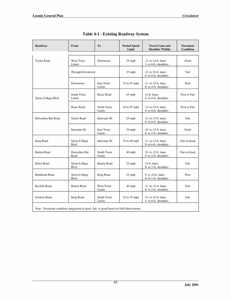
Loomis General Plan Circulation
July 2001
65
Table 4-1 - Existing Roadway System
Roadway
From
To
Posted Speed
Limit
Travel Lane and Shoulder Widths
Pavement Condition
Taylor Road
West Town Limits
Downtown
35 mph
12- to 14-ft. lanes 3- to 8-ft. shoulders
Good
Through Downtown
25 mph
12- to 16-ft. lanes 0- to 8-ft. shoulders
Fair
Downtown
East Town Limits
35 to 45 mph
11- to 12-ft. lanes 0- to 4-ft. shoulders
Poor
Sierra College Blvd.
South Town Limits
Brace Road
45 mph
12-ft. lanes 6- to 8-ft. shoulders
Poor to Fair
Brace Road
North Town Limits
45 to 55 mph
12- to 14-ft. lanes 4- to 8-ft. shoulders
Poor to Fair
Horseshoe Bar Road
Taylor Road
Interstate 80
25 mph
12- to 15-ft. lanes 0- to 8-ft. shoulders
Fair
Interstate 80
East Town Limits
30 mph
10- to 12-ft. lanes 0- to 2-ft. shoulders
Good
King Road
Sierra College Blvd.
Interstate 80
35 to 40 mph
11- to 12-ft. lanes 0- to 6-ft. shoulders
Fair to Good
Barton Road
Horseshoe Bar Road
South Town Limits
40 mph
10- to 12-ft. lanes 0- to 2-ft. shoulders
Fair to Good
Brace Road
Sierra College Blvd.
Barton Road
35 mph
12-ft. lanes 0- to 2-ft. shoulders
Fair
Bankhead Road
Sierra College Blvd.
King Road
25 mph
9- to 10-ft. lanes 0- to 1-ft. shoulders
Poor
Rocklin Road
Barton Road
West Town Limits
40 mph
11- to 12-ft. lanes 0- to 2-ft. shoulders
Fair
Swetzer Road
King Road
North Town Limits
25 to 35 mph
12- to 15-ft. lanes 4- to 8-ft. shoulders
Fair
Note - Pavement condition categorized as poor, fair, or good based on field observations.
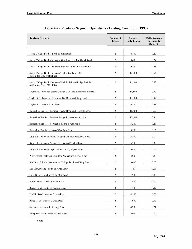
Loomis General Plan Circulation
July 2001
66
Table 4-2 - Roadway Segment Operations - Existing Conditions (1998)
Roadway Segment
Number of
Lanes
Average
Daily Traffic
Daily Volume-
to-Capacity Ratio (1)
Sierra College Blvd. - north of King Road
2
6,100
0.27 Sierra College Blvd. - between King Road and Bankhead Road
2
5,400
0.24 Sierra College Blvd. - between Bankhead Road and Taylor Road
2
9,300
0.41 Sierra College Blvd. - between Taylor Road and I-80 (within the City of Rocklin)
2
12,300
0.54
Sierra College Blvd. - between Rocklin Rd. and Ridge Park Dr. (within the City of Rocklin)
2
14,400
0.63
Taylor Rd. - between Sierra College Blvd. and Horseshoe Bar Rd.
2
10,500
0.70 Taylor Rd. - between Horseshoe Bar Road and King Road
2
13,800
0.92 Taylor Rd. - east of King Road
2
6,100
0.41 Horseshoe Bar Rd. - between Taylor Road and Magnolia Ave.
2
10,400
0.69 Horseshoe Bar Rd. - between Magnolia Avenue and I-80
2
12,600
0.84 Horseshoe Bar Rd. - between I-80 and Brace Road
2
5,300
0.23 Horseshoe Bar Rd. - east of Oak Tree Lane
2
3,500
0.15 King Rd. - between Sierra College Blvd. and Bankhead Road
2
2,200
0.14 King Rd. - between Arcadia Avenue and Taylor Road
2
5,300
0.35 King Rd. - between Taylor Road and Boyington Road
2
3,900
0.26 Webb Street - between Saunders Avenue and Taylor Road
2
3,500
0.23 Bankhead Rd. - between Sierra College Blvd. and King Road
2
3,400
0.23 Del Mar Avenue - north of Alvis Court
2
400
0.03 Laird Road - south of High Cliff Road
2
1,900
0.08 Barton Road - south of Brace Road
2
1,400
0.06 Barton Road - north of Rocklin Road
2
1,700
0.07 Rocklin Road - west of Barton Road
2
4,500
0.20 Brace Road - west of Barton Road
2
1,800
0.08 Swetzer Road - north of King Road
2
4,900
0.21 Humphrey Road - north of King Road
2
2,000
0.09
Notes:

Loomis General Plan Circulation
July 2001
67
(1) Volume to capacity ratio means the volume of current traffic in relation to the maximum amount of traffic the roadway can safely accommodate. For example, a volume to capacity ratio of 0.21 means that the current traffic volume is at 21 percent of the capacity of the roadway segment.

Loomis General Plan Circulation
July 2001
68
INSERT Figure 4-1: existing peak hour volumes

Loomis General Plan Circulation
July 2001
69

Loomis General Plan Circulation
July 2001
70
Peak hour intersection operations were evaluated by computing the level of service (LOS) at each intersection. Level of service is a term that describes the operating performance of an intersection or roadway, and is reported on a scale from A to F, with A representing the best performance and F representing the worst. Table 4-3 relates the operational characteristics associated with service level category.
Table 4-3 - Intersection Level of Service Definitions
Level of Service
Description
Unsignalized Intersections
(Average Delay)
Signalized Intersections
(Average Delay)
A Represents free flow. Individual users are virtually unaffected by others in the traffic stream.
< 5 sec/veh
< 5 sec/veh
B
Stable flow, but the presence of other users in the traffic stream begins to be noticeable.
5.1 - 10.0 sec/veh
5.1 - 15.0 sec/veh
C
Stable flow, but the operation of individual users becomes significantly affected by interactions with others in the traffic stream.
10.1 - 20.0 sec/veh
15.1 - 25.0 sec/veh
D
Represents high-density, but stable flow.
20.1 - 30.0 sec/veh
25.1 - 40.0 sec/veh
E
Represents operating conditions at or near the capacity level.
30.1 - 45.0 sec/veh
40.1 - 60.0 sec/veh
F
Represents forced or breakdown flow.
> 45 sec/veh
> 60 sec/veh
Sources: Highway Capacity Manual - Special Report 209 (Transportation Research Board, 1994).
Intersections were analyzed using the methodology contained in the Highway Capacity Manual - Special Report 209 (Transportation Research Board, 1994). This methodology determines the level of service by computing the average delay per vehicle and comparing the results to the thresholds shown in Table 4-3. Table 4-4 shows the existing AM and PM peak hour levels of service at each intersection.

Loomis General Plan Circulation
July 2001
71
Table 4-4 - Peak Hour Intersection Operations - Existing Conditions
Intersection
Control
AM Peak Hour
PM Peak Hour
Average
Delay (sec/veh)
Level of Service
Average
Delay (sec/veh)
Level of Service
Taylor Road/Oak Street
2-way stop
< 5.0
A
< 5.0
A Taylor Road/Walnut Street
2-way stop
< 5.0
A
< 5.0
A Taylor Road/Horseshoe Bar Road
Signal
21.8
C
13.8
B Taylor Road/Webb Street
2-way stop
< 5.0
A
< 5.0
A Taylor Road/King Road
Signal
30.9
D
22.9
C King Road/Webb Street
2-way stop
< 5.0
A
< 5.0
A King Road/Sierra College Boulevard
2-way stop
< 5.0
A
< 5.0
A Taylor Road/Sierra College Road
Signal
16.9
C
18.4
C I-80 Westbound Ramps/Horseshoe Bar Road
Signal
15.4
C
17.5
C I-80 Eastbound Ramps/Horseshoe Bar Road
2-way stop
< 5.0
A
6.8
B I-80 Westbound Ramps/Sierra College Blvd.
Signal
24.3
C
22.8
C I-80 Eastbound Ramps/Sierra College Blvd.
Signal
12.7
B
21.7
C
Table 4-4 shows that each intersection currently operates at LOS C or better during the AM and PM peak hours with the exception of the Taylor Road/King Road intersection, which operates at LOS D during the AM peak hour. Field observations indicate that this intersection actually operates at LOS E or F during the peak 30 minutes in the morning when school is in session. To avoid this congested intersection, many motorists use Webb Street to travel between northwest Loomis and the downtown area. Although the Taylor Road/Horseshoe Bar Road intersection operates at LOS C or better during each peak hour, field observations indicated significant queuing of northbound right-turn vehicles (queues extended beyond Laird Street), eastbound through vehicles, and westbound left-turn vehicles (queues exceeded the available turn lane storage). Sierra College Boulevard, Taylor Road, and Horseshoe Bar Road (north of I-80) carry the greatest volume of truck traffic in Loomis. Traffic counts conducted in September 1997 revealed that the segments of Taylor Road and Horseshoe Bar Road through the downtown area carried about 400 to 450 trucks (three or more axles) per day. This represents between two and four percent of all traffic on these roadways. With the exception of Sierra College Boulevard, none of the roadways within Loomis are posted as truck routes. King Road has “Not a Truck Route” signs, while Brace Road has signs indicating truck weight restrictions.

Loomis General Plan Circulation
July 2001
72
The presence of the Union Pacific Railroad tracks limits access between northwest Loomis and the downtown area. At-grade crossings are currently provided at King Road, Webb Street, and Sierra College Boulevard. Union Pacific Railroad representatives and the Loomis Fire Protection District are concerned about the close spacing (about 1,000 feet) of the railroad crossings at Webb Street and King Road. Given that trains frequently exceed 1,000 feet in length, it is possible that a slow moving or stopped train could simultaneously block the Webb Street and King Road at-grade crossings. The primary connections between southeast Loomis and the downtown area (i.e., across I-80) are Horseshoe Bar Road and Brace Road. These two roads have narrow travel lanes and little or no paved shoulders, which limits travel speeds for emergency vehicles. Bus Service Public bus service is provided to the Loomis area by Placer County Transit. The Loomis-Penryn Shuttle interconnects Loomis, Penryn, Lincoln, and Sierra College in Rocklin. This route has stops within Loomis at Taylor Road/King Road, Flag Stop (at Stahr Liquor Store), Del Oro High School, and Raleys. Service is provided between 6:30 AM and 4:15 PM, Monday through Friday, with four stops per day. Loomis is also served by the Auburn-Roseville Express Shuttle, which runs from 6:00 AM to 8:00 PM Monday through Friday, and 10:00 AM to 6 PM on Saturday. This service operates with one-hour headways (the time between bus pick-ups/drop-offs). Bicycle/Pedestrian System The existing bicycle system consists of a series of Class I (off-street trails) and Class II (on-street lanes with guide signs and pavement marking) bike lanes on major arterials. A Class I bike trail exists on the south side of Taylor Road between King Road and Del Oro High School. A short portion of King Road east of Bankhead Road also features a Class I bike trail. Class II bike lanes are provided on the following roadways: · Sierra College Boulevard (both sides) between Granite Drive and Del Mar Avenue; · Taylor Road (both sides) between Sierra College Boulevard and Oak Street; · Taylor Road (south side) between Oak Street and Webb Street; and · King Road between Sierra College Boulevard and I-80. Pedestrian facilities are located sporadically throughout the Loomis area. Sidewalks are provided on sections of Sierra College Boulevard, King Road, Taylor Road, Horseshoe Bar Road, and Swetzer Road, generally in locations where development has occurred. Crosswalks are provided at the four signalized intersections in Loomis and at numerous other unsignalized locations throughout the Town. Rail Service Existing train traffic through Loomis uses two tracks: westbound traffic uses the tracks adjacent to Taylor Road, while eastbound traffic uses the tracks near Sierra College Boulevard. Switching improvements may be made in the Loomis area so that passenger rail service will use the Taylor Road tracks for both directions of travel. The historic train station at the terminus of Horseshoe Bar Road is a possible location for future passenger service. The existing Capitol Corridor train service provides four trains per day in each direction between Sacramento and San Jose. Two trains per day extend east from Sacramento with stops in Roseville, Rocklin, Auburn, and Colfax. In the near future, passenger rail service may be expanded to include Loomis and Newcastle.

Loomis General Plan Circulation
July 2001
73
Existing Deficiencies Existing deficiencies of the roadway, bicycle/pedestrian systems are identified and displayed in Table 5. A review of the transit and rail systems did not reveal any existing deficiencies.
Table 4-5 - Existing Deficiencies
Facility
Description of Deficiency
Roadways Taylor Road through the downtown area
Existing traffic volumes are near the capacity of the road through the downtown area. Travel speeds through downtown are also perceived as excessive by many for pedestrian/bicycle safety.
Taylor Road east of the downtown area
Poor pavement condition and narrow travel lanes and shoulders results in difficult driving conditions.
Horseshoe Bar Road between I-80 and Taylor Road
Existing traffic volumes are near the capacity of the road.
Horseshoe Bar Road south of I-80
Sharp curves and narrow travel lanes and shoulders results in difficult driving conditions.
Bankhead Road and Barton Road
Narrow travel lanes and little or no paved shoulders result in difficult driving conditions.
Intersections Taylor Road/Horseshoe Bar Road Intersection
Significant delays occur on three of the four approaches due to heavy traffic volumes and inefficient signal timing.
Taylor Road/King Road Intersection
Significant delays occur in the morning when school is in session. Insufficient turn lane storage contributes to delays.
Sierra College Boulevard/Brace Road Intersection
Lack of left-turn bays on Sierra College Boulevard and a traffic signal results in operational problems and safety concerns.
Bicycle/Pedestrian System Taylor Road through the downtown area
The striping for the Class II bicycle lane is weathered and difficult to see. The Class II bicycle lane on the north side of Taylor Road terminates at Oak Street creating a gap to King Road.
Taylor Road, Sierra College Boulevard, King Road, and Horseshoe Bar Road
Sidewalks are discontinuous throughout Taylor Road, King Road, Sierra College Boulevard, and Horseshoe Bar Road.

Loomis General Plan Circulation
July 2001
74
C. Future Conditions This section provides an assessment of future transportation conditions assuming build-out of this General Plan land uses and Year 2020 development in the surrounding region. This “future baseline“ condition establishes the need for the improvements identified in the subsequent sections. Planned Transportation Improvements and Land Use Growth Future (2020) baseline conditions assume buildout of this General Plan and projected development in surrounding communities through 2020. It also assumes the following transportation improvements (as listed in the 1996 Draft Placer County Regional Transportation Plan): · Widen Sierra College Boulevard to six lanes immediately north of I-80, and to four lanes north
of Taylor Road; · Reconstruct the I-80/Sierra College Boulevard interchange; · Widen I-80 from a six-lane to an eight-lane freeway east and west of Horseshoe Bar Road; · Install bicycle lanes on Taylor Road from Midas Avenue (in Rocklin) to Sierra College
Boulevard and from King Road to the Loomis Town Limits; and · Attempt to provide passenger rail service in Loomis. The City of Rocklin 2020 traffic model, which covers the entire Sacramento region, was utilized to obtain future traffic forecasts because this model contains more zonal and roadway network detail than the other available models (SACMET, PCTPA models). The future land uses within Loomis were modified to reflect buildout of this General Plan. Future Travel Forecasts Figure 4-2 shows the average daily travel demands for Year 2020 conditions. Sierra College Boulevard is projected to carry between 17,100 vehicles per day south of King Road to 40,500 vehicles per day near the southern Town limits. This is an approximate three-fold increase over existing traffic that is primarily attributable to new developments, such as Twelve Bridges, Whitney Oaks, and Clover Valley Lakes planned in the surrounding communities. Traffic volumes on Taylor Road will range from about 11,500 vehicles per day near the north Town limits to about 18,200 vehicles per day through the downtown area. Traffic volumes on King Road, Swetzer Road, Webb Street, Barton Road, Laird Road, and Brace Road are expected to range from 2,500 to 11,400 vehicles per day. Table 4-6 summarizes the daily volume-to-capacity ratio for the major roadways assuming no physical improvements. This table shows that projected volumes will exceed the capacity on the segments of Taylor Road, Sierra College Boulevard, and Horseshoe Bar Road if these roads are not improved.

Loomis General Plan Circulation
July 2001
75
Table 4-6 - Roadway Segment Operations – Existing and Future Baseline Conditions
Roadway Segment
Existing Conditions
Future Baseline
Conditions2 Average
Daily Traffic
Daily V/C
Ratio1
Average Daily
Traffic
Daily V/C Ratio1
Sierra College Blvd. - north of King Road
6,100
0.27
25,000
1.09 Sierra College Blvd. - between King Road and Bankhead Road
5,400
0.24
19,100
0.83
Sierra College Blvd. - between Bankhead Road and Taylor Road
9,300
0.41
36,300
1.59 Sierra College Blvd. - between Taylor Road and I-80 (within the City of Rocklin)
12,300
0.54
48,300
2.11
Sierra College Blvd. - between Rocklin Rd. and Ridge Park Dr. (within the City of Rocklin)
14,400
0.63
44,800
1.96
Taylor Rd. - between Sierra College Blvd. and Horseshoe Bar Rd.
10,500
0.70
23,100
1.54 Taylor Rd. - between Horseshoe Bar Road and King Road
13,800
0.92
17,800
1.19 Taylor Rd. - east of King Road
6,100
0.41
11,700
0.78 Horseshoe Bar Rd. - between Taylor Road and Magnolia Ave.
10,400
0.69
17,300
1.15 Horseshoe Bar Rd. - between Magnolia Avenue and I-80
12,600
0.84
19,800
1.32 Horseshoe Bar Rd. - between I-80 and Brace Road
5,300
0.23
17,100
0.75 Horseshoe Bar Rd. - east of Oak Tree Lane
3,500
0.15
4,200
0.18 King Rd. - between Sierra College Blvd. and Bankhead Road
2,200
0.14
8,200
0.55 King Rd. - between Arcadia Avenue and Taylor Road
5,300
0.35
12,400
0.83 King Rd. - between Taylor Road and Boyington Road
3,900
0.26
11,700
0.78 Webb Street - between Saunders Avenue and Taylor Road
3,500
0.23
6,700
0.45 Bankhead Rd. - between Sierra College Blvd. and King Road
3,400
0.23
9,800
0.65 Del Mar Avenue - north of Alvis Court
400
0.03
3,900
0.26 Laird Road - south of High Cliff Road
1,900
0.08
4,900
0.21 Barton Road - south of Brace Road
1,400
0.06
7,300
0.49 Barton Road - north of Rocklin Road
1,700
0.07
7,400
0.49 Rocklin Road - west of Barton Road
4,500
0.20
18,400
0.80 Brace Road - west of Barton Road
1,800
0.08
12,400
0.54 Swetzer Road - north of King Road
4,900
0.33
6,400
0.43 Humphrey Road - north of King Road
2,000
0.13
6,800
0.45 Notes: 1 V/C Ratio = Volume-to-Capacity Ratio.
2 Assumes no physical improvements within the Town of Loomis.

Loomis General Plan Circulation
July 2001
76
INSERT Figure 4-2: future baseline volumes

Loomis General Plan Circulation
July 2001
77

Loomis General Plan Circulation
July 2001
78
Future Deficiencies Future deficiencies of the roadway, bicycle/pedestrian systems are identified and displayed in Table 4-7 assuming no improvements are made. A review of the transit and rail systems did not reveal any future deficiencies.
Table 4-7 - Primary Future Deficiencies (Without Any Improvements)
Facility
Description of Deficiency
Roadways Taylor Road, Horseshoe Bar Road, Sierra College Blvd, and Rocklin Road
Projected traffic volumes will exceed the capacity of these roadways in some or all sections.
Taylor Road (east of King) and King Road
Poor pavement condition, lack of turning lanes, and narrow travel lanes/shoulders will result in difficult driving conditions with increases in traffic volumes.
Horseshoe Bar Road south of Taylor Road
The lack of turning lanes and sidewalks will become more problematic with increases in traffic volumes.
Bankhead Road, Brace Road, Barton Road
Narrow travel lanes and little or no paved shoulders will result in difficult driving conditions with increased traffic volumes.
Intersections Taylor Road/Horseshoe Bar Road Intersection
Projected increases in traffic will significantly worsen operations at this intersection.
Taylor Road/King Road Intersection
Projected increases in traffic will significantly worsen operations at this intersection.
Sierra College Boulevard/Taylor Road/Union Pacific
This intersection will become extremely congested with future growth. While widening of Sierra College Boulevard will temporarily relieve the problem, a grade-separation will ultimately be needed.
Bicycle/Pedestrian System Bicycle Facilities in General
Bicycle facilities are sparse throughout the Town, and increased population and popularity of bicycle travel will create the need for additional facilities.
Taylor Road through the downtown area
The striping for the Class II bicycle lane is weathered and difficult to see. The Class II bicycle lane on the north side of Taylor Road terminates at Oak Street creating a gap to King Road.
Taylor Road, Sierra College Boulevard, King Road, and Horseshoe Bar Road
Sidewalks are discontinuous throughout Taylor Road, King Road, Sierra College Boulevard, and Horseshoe Bar Road.

Loomis General Plan Circulation
July 2001
79
D. Issues, Goals, Policies, and Implementation Measures The policies presented here cover a broad range of topic areas and were derived, in part, from existing policies currently in place in Loomis and other nearby jurisdictions. The General Plan Steering Committee provided direction on the content of the policies covering the following topics:
Level of service, Roadway improvement standards, Sidewalks, Bicycle routes, Transit service, Neighborhood environment, and Roadway system funding.
Level of Service Issue: Growth in traffic volumes from development approved within, and adjacent to, the Town will cause increased congestion and need for roadway improvements, depending upon the chosen service level standard. Goal: To strive for service levels that reflect a balance between mobility, cost-effectiveness, and financial resources.
Level of Service policy: In order to minimize congestion, maintain Level of Service C on all roads and intersections within the Town of Loomis. Level of Service D may be allowed in conjunction with development approved within the Town as an exception to this standard, at the intersections of King and Taylor, Horseshoe Bar Road and Taylor, Horseshoe Bar Road and I-80, Sierra College and Brace Road, and Webb and Taylor, when:
1. The deficiency is substantially caused by “through” traffic, which neither begins nor ends
in Loomis, and is primarily generated by non-residents; or
2. The deficiency will be temporary (less than three years), and a fully-funded plan is in place to provide the improvements needed to remedy the substandard condition.
Mitigation of impacts from unincorporated area projects. Notwithstanding any other General Plan policy or provisions, in the event that significant adverse impacts will result from the construction of large developments on the Town’s perimeter, the Town shall make every reasonable effort to have the developers adequately mitigate the adverse impacts.

Loomis General Plan Circulation
July 2001
80
Roadway Improvement Standards Issue: Many roadway improvements will be needed during the life of the General Plan and design standards are needed to ensure consistency and quality. Goal: To develop standards that protect public safety and provide mobility for all forms of transportation.
Roadway improvement policy: Roadway improvements within the Town of Loomis shall conform to the roadway classification system and improvement standards specified in the current version of the Town of Loomis Design & Improvement Standards after their adoption.
Policy on character of roadway improvements: The design of Downtown roadway and streetscape improvements will continue to maintain the “small town downtown” character.
Implementation measure: The Town will develop and adopt road and street improvement and design standards as funding permits. Bicycle Facilities Issue: Bicycle facilities are limited in Loomis. Provisions to increase bicycle use will provide recreational and mobility benefits to residents and reduce vehicular traffic. Goal: To implement additional bicycle facilities that result in increased bicycle usage.
Bicycle Facility Policies
1. The Town shall promote bicycle travel, as appropriate, and shall pursue all available sources of funding for the development and improvement of bicycle facilities.
2. Bicycle facilities shall be provided in compliance with the Placer County Bikeways Master
Plan (Placer County Transportation Commission, 1988) or subsequent amended versions of that document, as well as on other appropriate routes at the discretion of the Town Council.
Transit Service Issue: Transit service is limited within the Town, providing little incentive for its use and limited options for transit-dependent persons. Goal: To devote resources for the promotion of transit service that are appropriate for its size and financial resources using comparable cities as a benchmark.
Transit Service Policies
1. The Town will promote and support a safe, efficient, and coordinated public transit system that meets residents’ needs, reduces congestion, improves the environment, and helps provide a viable non-automotive means of transportation in and through the Town of Loomis.
Loomis General Plan Circulation
July 2001
81
2. The Town should work with Placer County Transit and other transit providers to plan and implement public transportation services within the Town that are timely, cost-effective, and responsive to growth patterns and transit demand.
a. Transit routes should conform to plans established by Placer County Transit, and
should generally coincide with major destinations for employment and shopping, the location of major institutions, concentrations of multifamily housing, and other land uses likely to attract public transit ridership.
b. Bus routes should follow major roads with service to residential neighborhoods via
collector streets.
c. Bus stops should be located in conformance with the applicable policies of Placer County Transit.
3. The Town should consider the transit needs of senior, disabled, minority, low-income, and
transit-dependent persons in making decisions regarding transit services and in compliance with the Americans with Disabilities Act.
4. The Town should support efforts to provide demand-responsive service (“paratransit”) and
other transportation services for those unable to use conventional transit. Neighborhood Environment Issue: Increased development within, and adjacent to the Town, creates possibility for traffic intrusion into residential neighborhoods. Goal: To take actions to minimize cut-thru traffic and manage speeds on residential streets.
Neighborhood Environment Policies:
1. The Town shall create and maintain a street system which protects residential neighborhoods from unnecessary levels of traffic, while providing for logical traffic circulation.
2. The Town shall design streets and approve development in such a manner as to prevent
and eliminate high traffic flows and parking problems within residential neighborhoods.
3. The Town shall promote the development of a circulation system that preserves the historic nature and character of neighborhoods and districts, and reinforces neighborhood identity and integrity.
4. New local streets shall be designed to promote the interconnection of residential
neighborhoods while simultaneously discouraging through-traffic within residential neighborhoods.
5. The Town of Loomis shall establish and maintain a procedure through which local
residents can receive assistance in managing and reducing traffic flows through their residential neighborhoods. Such assistance could be technical, the provision of equipment (such as signs) and the labor needed to install such equipment, or the provision of
Loomis General Plan Circulation
July 2001
82
enhanced police traffic enforcement in neighborhoods. The Town could also participate in modifying the existing street system to reduce or eliminate through traffic intrusion into residential neighborhoods. Such modifications could include installation of speed humps, traffic diverters, traffic circles, or a variety of other techniques. Based on the identified need and available financing, priorities will be established and an appropriate level of resources (including staff time, equipment, and physical improvements) will be committed by the Town.
6. If recommended by the Town Engineer after review, and if determined to be feasible, the
Town should pursue the construction of a pedestrian bridge over Sierra College Boulevard to address safety impacts. The precise location of the crossing would be determined after further review.
Roadway System Funding Issue: Transportation improvements are expensive and the Town has very limited financial resources. Goal: To leverage the Town’s resources with outside funding sources (developer fees, state funds, federal funds, etc.).
Roadway System Funding Policies
1. The Town shall aggressively pursue state and federal funding to implement the primary elements of the Town’s Circulation Plan.
2. The Town shall require proposed new development projects to analyze their contribution
to increased vehicle, pedestrian, and bicycle traffic and to implement the roadway improvements necessary to address their impact.
3. The Town shall assess fees on new development sufficient to cover the fair share portion
of development’s cumulative impacts on the local and regional transportation system. The cost of all on-site roadways within new development projects is the responsibility of the developer.
4. Prior to acceptance of new local streets by the Town, provisions shall be made for the
ongoing maintenance of those facilities. Such provisions could include the establishment of a maintenance district covering the specific roadways identified, or assumption of all maintenance responsibilities by the pertinent homeowners association or other approved organization.
Loomis General Plan Circulation
July 2001
83
Roadway Maintenance Issue: Financial constraints can lead to improper maintenance, which reduces the quality and longevity of facilities. Goal: To create a pavement management system that provides timely and accurate information about how to use maintenance resources.
Roadway Maintenance Policies
1. The Town shall assure that the transportation system continues to provide safe, efficient, and convenient access to its residents.
2. The Town shall provide dependable and adequate resources to maintain and repair the
existing system of roads and bridges, according to priorities established on an annual basis.
3. The Town shall work with the Placer County Transportation Planning Agency (PCTPA) to ensure that the PCTPA’s Regional Transportation Plan is coordinated with the Town’s Capital Improvement Plan. This coordination will allow access to Federal and State funds, where possible, for road maintenance and improvements.
Loomis General Plan Circulation
July 2001
84
E. Transportation System Improvements
This section presents capital improvements to the transportation system for the Town of Loomis. The preferred system will need to be phased as the needs occur and the funding is available, as the proposed circulation improvements are intended to support build-out conditions. Roadway Network Improvements to the roadway network are intended to address several future problems: · Insufficient capacity at several locations to support build-out of the Town and growth in the
surrounding communities; · Excess “through” traffic and trucks along Taylor Road through the downtown; · A desire to create a more pedestrian-friendly environment in downtown; and · Safety issues related to vehicular traffic. Downtown-Related Improvements A focused study was conducted by the Town of Loomis in 1997 (Downtown Loomis Parking and Circulation Study, Fehr & Peers Associates) to address parking and circulation conditions along Taylor Road and a portion of Horseshoe Bar Road. This study evaluated several alternatives that were intended to reduce traffic congestion, improve truck circulation, enhance pedestrian/bicycle circulation and safety, and improve parking. The 1997 downtown study used a combination of engineering analysis and public input to identify a preferred circulation system. The public input consisted of: · a Technical Advisory Committee that provided general guidance; · extensive public opinion surveys; · two public workshops; and · a joint workshop of the Economic Development Commission, Planning Commission, and Town
Council. The primary elements of the preferred circulation system from the 1997 study are as follows:
Swetzer Road Extension (Figure 4-3) – is the construction of a two-lane roadway from King Road to Sierra College Boulevard immediately north of the Union Pacific Railroad tracks. This improvement would be largely within the railroad right-of-way in an area that cannot be developed with buildings due to its proximity to the tracks.
Boyington Road Extension (Figure 4-3) – is the construction of a two-lane freeway frontage road from King Road to Horseshoe Bar Road north of the Raley’s Shopping Center, with a short extension to connect with Walnut Street. The structural improvements will include two traffic lanes, bike lanes on both sides, and parkway strip landscaping and sidewalks on both sides, within a 70-foot wide right-of-way. The location/alignment of this extension will be determined at the time subdivision or other development of the presently vacant properties is proposed.
Loomis General Plan Circulation
July 2001
85
Miscellaneous Core Improvements (Figure 4-4) – consists of a series of localized improvements on Taylor Road that are designed to improve local circulation and parking. Some of the key elements include:
· visual gateways on Taylor Road that all serve a traffic calming function; · modifications to the Horseshoe Bar/Taylor intersection to provide an “uninterrupted” right-
turn from Horseshoe Bar Road to Taylor Road; · a one-way circulation system to/from the new train depot with on-street parking, bus
turnout, and drop-off facility; · a pedestrian/local traffic only facility adjacent to the fruit sheds (between Walnut Street
and Horseshoe Bar Road); · continuous bike lane on Taylor Road throughout the downtown; and · new traffic signals on Taylor road at Webb Street, Walnut Avenue, and Circle Drive.
Other Improvements Figure 4-5 shows other improvements anticipated to be needed at build-out of this General Plan. Most of the improvements are safety and/or operational related (such as providing paved shoulders, turning lanes, or signals). However, some roads will need additional through lanes for capacity: · Sierra College Boulevard – 4 lanes north of Bankhead Road and 6 lanes south of Bankhead. · Horseshoe Bar Road – 4 lanes from Boyington Road Extension to the southern edge of
commercial development. The Horseshoe Bar Road/I-80 interchange will also undergo improvement, with the specific details (number of lanes, ramp configurations, etc.) determined by a future Project Study Report.
· Rocklin Road – 4 lanes from Sierra College Boulevard to Barton Road, and 2 lanes from Barton Road to the east, possibly connecting with Laird Road along an alignment north of existing Rocklin Road. The exact alignment will be determined at a future date.
King Road should be improved to provide turning lanes at major cross-streets. The portion of Horseshoe Bar Road between Taylor and the Boyington Road Extension should also be improved to provide a continuous turn lane along with curb, gutter, and sidewalk. Taylor Road (east of King Road) should be improved to provide turning lanes at major cross-streets and curb, gutter, and sidewalk. The Sierra College Boulevard interchange will need to be widened and improved. Some widening of the Taylor Road/King Road intersection will likely be needed depending upon the enrollment and operation of the adjacent Loomis Grammar School and Del Oro High School. Brace Road, Barton Road, and Bankhead Road will all warrant upgrades that provide for standard lane widths and paved shoulders. Several intersections will likely warrant signalization and/or turning lanes. Figure 4-5 identifies some of the more likely locations, but the identified locations are neither definitive nor exhaustive. The Town may consider an interchange at King Road and Interstate 80 in the future. Residents have been concerned about “through” traffic on Del Mar Avenue and the incentives for additional through traffic will increase as travel times increase on Sierra College Boulevard and Taylor Road. In response, the Town will evaluate the potential for the closure of Del Mar Avenue within one month of the adoption of this updated General Plan.
Loomis General Plan Circulation
July 2001
86
Bicycle/Pedestrian Facilities The following are the recommended bicycle facility improvements (Figure 4-6) to complement or upgrade the existing system: · Provide westbound on-street bike lane (Class II) on Taylor Road from King Road to Oak Street
to match existing eastbound facility; · Provide on-street (Class II) facilities on Taylor Road (from King Road to eastern Town Limits
and Sierra College Boulevard to western Town Limits), Sierra College Boulevard (within entire Town Limits), Rocklin Road (within entire Town Limits), Horseshoe Bar Road (from the Tourist/Destination Commercial designation south of I-80 to the Boyington Road extension); and
· Provide on-street (Class III) facilities on Bankhead Road (King to Sierra College), Saunders
Avenue (Bankhead to eastern limit), South Walnut/Stone Road, Brace Road, and Laird Road. In most cases, these facilities will consist of paved shoulders and appropriate signage.
Sidewalks should be made continuous along Taylor Road, Sierra College Boulevard, King Road, and Horseshoe Bar Road. The policy section of the Circulation Element provides a description of the Town’s policy regarding sidewalks on new roadways. Transit Service Only one capital improvement is planned with respect to transit; namely, the revitalization of the rail station near Horseshoe Bar Road and Taylor Road. Improvements to the platform, station, circulation, and parking facilities are desirable. Figure 4-4A shows the conceptual circulation system. While passenger rail service is not imminent, this facility will become a future “hub” of transit service (both rail and bus) in Loomis. Table 4-8 summarizes the probable timing and estimated cost for transportation-related capital improvements.
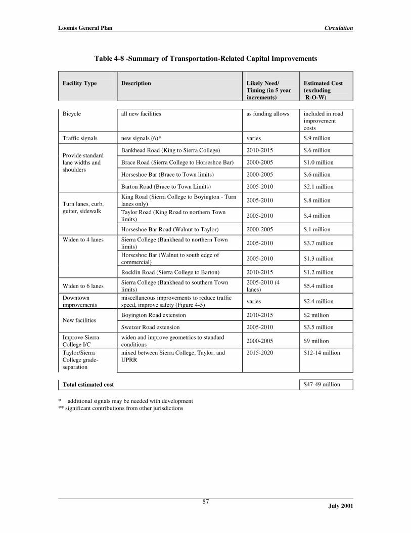
Loomis General Plan Circulation
July 2001
87
Table 4-8 -Summary of Transportation-Related Capital Improvements
Facility Type
Description
Likely Need/ Timing (in 5 year increments)
Estimated Cost (excluding R-O-W)
Bicycle
all new facilities
as funding allows
included in road improvement costs
Traffic signals
new signals (6)*
varies
$.9 million
Bankhead Road (King to Sierra College)
2010-2015
$.6 million
Brace Road (Sierra College to Horseshoe Bar)
2000-2005
$1.0 million
Horseshoe Bar (Brace to Town limits)
2000-2005
$.6 million
Provide standard lane widths and shoulders
Barton Road (Brace to Town Limits)
2005-2010
$2.1 million
King Road (Sierra College to Boyington - Turn lanes only)
2005-2010
$.8 million
Taylor Road (King Road to northern Town limits)
2005-2010
$.4 million
Turn lanes, curb, gutter, sidewalk
Horseshoe Bar Road (Walnut to Taylor)
2000-2005
$.1 million
Sierra College (Bankhead to northern Town limits)
2005-2010
$3.7 million
Horseshoe Bar (Walnut to south edge of commercial)
2005-2010
$1.3 million
Widen to 4 lanes
Rocklin Road (Sierra College to Barton)
2010-2015
$1.2 million
Widen to 6 lanes
Sierra College (Bankhead to southern Town limits)
2005-2010 (4 lanes)
$5.4 million
Downtown improvements
miscellaneous improvements to reduce traffic speed, improve safety (Figure 4-5)
varies
$2.4 million
Boyington Road extension
2010-2015
$2 million
New facilities
Swetzer Road extension 2005-2010
$3.5 million
Improve Sierra College I/C
widen and improve geometrics to standard conditions
2000-2005
$9 million
Taylor/Sierra College grade-separation
mixed between Sierra College, Taylor, and UPRR
2015-2020
$12-14 million
Total estimated cost
$47-49 million
* additional signals may be needed with development ** significant contributions from other jurisdictions

Loomis General Plan Circulation
July 2001
88
INSERT Figure 4-3

Loomis General Plan Circulation
July 2001
89

Loomis General Plan Circulation
July 2001
90
INSERT Figure 4-4a

Loomis General Plan Circulation
July 2001
91

Loomis General Plan Circulation
July 2001
92
INSERT Figure 4-4b

Loomis General Plan Circulation
July 2001
93

Loomis General Plan Circulation
July 2001
94
INSERT Figure 4-5

Loomis General Plan Circulation
July 2001
95

Loomis General Plan Circulation
July 2001
96
INSERT Figure 4-6

Loomis General Plan Circulation
July 2001
97

Loomis General Plan Housing
July 2001
98
V. Housing
Introduction Overview of the Housing Element The information in this Chapter excerpts the key policy information from the 1993 update of the Housing Element of the General Plan for the Town of Loomis. The California Government Code (Sections 65580 and following) requires that each City and County review and update its Housing Element according to an update schedule established by the California State Department of Housing and Community Development (HCD). The purpose of the Housing Element is to analyze housing needs for all income levels and housing types and provide a detailed plan to create housing opportunities. The goals of the Plan are based on the Regional Housing Allocation Plan for the Sierra Planning Organizations, and on local policies, which contribute to the development of safe and adequate housing for the existing and future residents of the Town of Loomis. Organization and Content of the Housing Element The format of the Housing Element closely follows the Housing Element Guidelines published by the State of California, Department of Housing and Community Development. The basic requirements of a Housing Element are addressed and organized into the following major areas: · A review and performance evaluation of the most recent 1987 Housing Element. In this section,
the previously adopted housing goals will be reviewed along with an evaluation of progress in meeting goals.
· An assessment of housing needs based on demographic data for the area, including an assessment
of specialized housing needs to address special populations such as the homeless. · An inventory of land resources including vacant land, zoning and actions to increase housing
supply. · A discussion of constraints and barriers to the development of new housing opportunities. · A discussion of efforts and possibilities to make housing more energy efficient. · A statement of housing goals including quantitative goals based on the Regional Housing
Allocation Plan. · A brief discussion of possibilities for low and moderate income housing funds generated by
Redevelopment Agencies pursuant to the Community Redevelopment Act. The Town of Loomis does not currently have an adopted redevelopment area.
· A brief discussion of strategies to preserve existing assisted housing, including conversions or
"opt outs". Currently, the Town of Loomis has no existing assisted housing that is threatened.

Loomis General Plan Housing
July 2001
99
· Housing policies and recommendations to be adopted and pursued as part of the Housing Element Update.
· An implementation program and schedule. All the above components except for the Housing Element policies, and implementation program and schedule can be found in the Background Report. The policies, implementation programs and schedule follow. Relationship to Other General Plan Elements State Planning Law requires that all elements of the General Plan be internally consistent to avoid policy conflicts. The recommendations of this Housing Element are consistent with and support the adopted General Plan. This Housing Element is also consistent with the Regional Housing Allocation Plan for the region and also reflects the appropriate research and conclusions of the recently prepared Placer County Housing Element.
Housing Element Goals, Policies, and Programs This section describes the proposed goals, policies and programs which the Town of Loomis will endorse and pursue to implement the Regional Housing Assistance Plan Goals. To the extent possible, the goals, policies and programs mirror many of the policies of the Placer County Housing Element in order to ensure regional consistency and to allow for coordination of resources and approaches. In addition, housing goals and objectives by program are quantified. The Regional Housing Allocation Plan sets numeric goals by income type for each jurisdiction to seek to achieve. In the Housing Element the housing needs, resources and opportunities for the Town of Loomis have been considered. Programs are suggested in these policies which support the numeric goals and respond to the needs identified by the Town of Loomis. In general, the Town of Loomis has relatively high household sizes and relatively high proportion of family housing need. An additional trend is a substantial increase in single parent households with children. A second emerging trend is the need for senior housing based on the increase in senior households over the last decade. Based on these findings, it is recommended that the Town of Loomis pursue both additional family housing for all income levels and senior housing. For very low income and low income households financial subsidies will be required. Since Federal and State housing assistance changes over time, recommendations are made based on current types of programs available. Certainly if future programs become available, the policies support exploration of these programs. For very low and low income family housing, a combination of rehabilitation and new construction program is recommended. New construction programs which could serve very low and low income family housing needs include: Self-help housing, manufactured housing, townhouses or duplexes and second units. As noted through-out the Element, to meet very low income needs, State and Federal assistance will be required.

Loomis General Plan Housing
July 2001
100
Similarly, for senior housing a combination of rehabilitation and construction program is recommended. New construction programs include second homes or carriage units, and new townhouse or apartment development. A. Affordable Housing Supply GOAL A: To provide a continuing supply of affordable housing to meet the needs of
existing and future residents of the Town of Loomis in all income categories. Policies A.1 The Town shall adopt these policies, programs and procedures with the intent of achieving its fair
share regional housing allocation, including the number of units for each income classification. A.2 The Town shall maintain an adequate supply of appropriately zoned land with public services to
accommodate projected housing needs in accordance with the General Plan. A.3 The Town shall ensure that its adopted policies, regulations and procedures do not add
unnecessarily to the cost of housing while still attaining other important Town objectives. A.4 The Town shall give highest priority for permit processing to development projects that include a
lower income residential component. A.5 The Town shall encourage "mixed-use" projects where housing is provided in conjunction with
compatible non-residential uses. The Town shall promote the mixed use polices of the Town Center Master Plan to encourage development of mixed uses.
A.6 The Town shall cooperative with the County of Placer in its efforts to establish a public housing
authority serving the Placer County area. A.7 The Town shall support the County of Placer's efforts to create of a nonprofit housing
development corporation whose primary focus will be to serve the Placer County area. The Town will also work with other qualified non-profit sponsors in the development of affordable housing in the Town.
A.8 The Town shall, through a public housing authority and/or in conjunction with nonprofit or for
profit developers with a project application before the Town, apply for appropriate State or Federal funds to assist the construction housing for low income households.
A.9 The Town should continue to collect the Low Income Fee on all developments over five units in
size and shall disperse funds collected towards the furtherance of the goals contained in this Housing Element.
A.10 Inclusionary housing provisions shall be considered in any update of the General Plan or
substantial amendment to the General Plan. A.11 Housing for low-income households that is required in a new residential project shall not be
concentrated into a single building or portion of the site but shall be dispersed throughout the project, to the extent practical, given the size of the project and other site constraints.

Loomis General Plan Housing
July 2001
101
A.12 The Town shall encourage low income housing units in density bonus projects to be available at the same time as the market-rate units in the project.
A.13 The Town will encourage the development of multi-family dwellings in locations where adequate
facilities are available, such as the Town Center and where such development would be consistent with neighborhood character.
A.14 The Town will allow dwellings to be rehabilitated that do not meet current lot size, setback, and
yard requirement, and other current zoning standards, so long as the non-conformity is not increased and there is no threat to public health and/or safety.
A.15 The Town will continue to encourage the appropriate development of Second Residential Units
to expand the housing supply and unit mix. A.16 The Town will consider allowing a legal non-conforming status or grandfather clause for any
existing non-substandard second units. A.17 the Town of Loomis will explore and encourage innovative housing alternatives such as well
designed manufactured units or self help units as a means to diversify the housing stock and affordability.
Programs A.1.1 As part of the Town Center Master Plan, the Town will review land use patterns, existing
densities, the location of job centers and the availability of services to identify additional areas that may be suitable for higher density residential development in areas where public services can support new development.
Responsible Entity: Town Planner Timeframe: Begin 1994, complete by 1997 Desired Result: Implementation of the mixed use concept of the Town Center Master
Plan and increased range of housing opportunities for residents. A.1.2 Within the Town Center, the Town will continue to pursue strategies for providing adequate
water and sewer services and drainage facilities for the areas designated for residential development.
Responsible Entity: Town Engineer Timeframe: 1994 and on-going Desired Result: Full implementation of the mixed use concept of the Town Center Master
Plan through supportive public/private financing programs to eliminate barriers to development.
Loomis General Plan Housing
July 2001
102
A.1.3 The Town will continue to implement the permit assistance program for residential projects including pre-application meetings, flexibility in lot size as allowed under the new zoning ordinance amendments, and streamlining of second residential unit approval process.
Responsible Entity: Town Planner Timeframe: 1994 Desired Result: Approval of the proposed amendments to the Zoning Ordinance to
streamline the processing of Second Residential Units and implementation of the recently adopted amendments which allow small lot subdivisions.
A.1.4 The Town Planner and Planning Commission will establish a procedure for giving highest
priority in the review process to low income housing projects.
Responsible Entity: Town Planner and Planning Commission Timeframe: 1994 and on-going Desired Result: Provide an incentive to qualified sponsors of affordable housing projects
to encourage the production or rehabilitation of housing. A.1.5 The Town will continue efforts to amend the "second unit" provisions of the zoning ordinance to
allow detached secondary units when such units are located above a garage or similar accessory building on lots less than 1.0 acre where appropriate services are available and the impacts on neighborhood character are not significant. The ordinance will provide specific guidance as to the circumstances in which detached second units are acceptable. The Town will identify existing "illegal" second homes through the Housing Conditions Survey and consider a "grandfather" clause or legal nonconforming use provision to preserve these units.
Responsible Entity: Town Planner Timeframe: 1994 to December 1995 Desired Result: Approval of the proposed amendments to the Zoning Ordinance to
encourage and protect Second Residential Units and to streamline the processing of Second Residential Units. Achieve a portion of RHAP goals through encouraging the production of 10 to 20 units of this type over the next five years.
A.1.6 The Town will continue to coordinate with the City of Roseville and Placer County in the
development of a regional Landbanking and Financing Pool to assist with the production of affordable housing.
Responsible Entity: Town Manager and Town Planner Timeframe: 1997 Desired Result: Provide incentives to qualified sponsors of affordable housing projects to
encourage the production or rehabilitation of housing. Leverage local resources to achieve greater results than might occur by individual smaller jurisdictions working independently.

Loomis General Plan Housing
July 2001
103
A.1.7 The Town will cooperate with the County of Placer in developing a public housing authority and/or a non-profit housing development corporation.
Responsible Entity: Town Manager Timeframe: 1997 Desired Result: Support efforts to provide additional avenues for public funding and
operation of affordable housing in the Town and in the South Placer Region.
A.1.8 The Town will continue to implement the following incentive programs for the construction of
affordable housing:
a. Allow second residential units with single family residences. b. Allow mobile homes and manufactured housing in all residential zoning districts. c. Allow "hardship mobile homes" as second residential units in residential and/or agricultural
zones. d. Allow density bonuses for the construction of units for low and very low income residents,
and for housing projects for seniors. e. Consider "cluster developments" in more remote areas in order to reduce site improvement
costs, allow more efficient use of developable lands and conserve open space.
Responsible Entity: Town Planner Timeframe: 1994 and on-going as part of General Plan review discussions Desired Result: Provide additional incentives to qualified sponsors of affordable housing
projects to encourage the production of affordable housing. A.1.9 The Town will amend the current density bonus ordinance to conform with the requirements of
state law with regard to additional incentives and to provide a 25 percent density bonus if 20 percent (the current ordinance requires 25 percent) of the units are available to low income households.
Responsible Entity: Town Planner Timeframe: 1994 Desired Result: Provide additional incentives to qualified sponsors of affordable housing
projects to encourage the production of affordable housing. A.1.10 The Town will continue to seek financial resources to support affordable housing through
applying for Community Development Block Grant (CDBG) Funds, collecting the Low Income Density Bonus Fee and pursuing other financing resources as appropriate.
Responsible Entity: Town Planner Timeframe: 1994 and 1995 Desired Result: Provide appropriate financial incentives to qualified sponsors of
affordable housing projects to encourage the production of affordable housing.

Loomis General Plan Housing
July 2001
104
A.1.11 The Town will continue to identify financial institutions operating in the Town that fall under the requirements of the Community Reinvestment Act and request that these institutions develop specific programs for providing financing for low and moderate income housing.
Responsible Entity: Town Manager and Town Planner Timeframe: 1995 and 1996 Desired Result: Provide an incentives to qualified sponsors of affordable housing projects
to encourage the production or rehabilitation of housing. Leverage local resources to achieve greater results than might occur by individual smaller jurisdictions working independently.
A.1.12 The Town of Loomis will work with qualified sponsors to develop and apply for all feasible and
appropriate housing assistance funds such as Self Help Housing, HOME funding and CDBG funding with a particular emphasis on pursuing development programs and funds which meet very low and low income needs. Responsible Entity: Town Planner Timeframe: 1994 and on-going Desired Result: Provide appropriate financial incentives to qualified sponsors of
affordable housing projects to encourage the production of affordable housing.
B. Quality of Design GOAL B: To promote quality residential development in the Town. Policy B.1 The Town encourages residential development of high architectural and physical quality,
compatible with neighboring land uses. Program B.1.1 The Town will continue to develop reasonable design guidelines which are responsive to
changing markets, desired amenities and which allow for a range of well designed housing choices.
Responsible Entity: Town Manager Timeframe: 1994 and on-going Desired Result: Ensure that developers have clear guidelines for design which preserve
community values without suppressing creativity. C. Conservation and Rehabilitation GOAL C: To conserve the Town's current stock of affordable housing. Policies C.1 The Town shall continue to apply for Community Development Block Grant (CDBG) grant
funding for the purpose of rehabilitating low cost, owner occupied and rental housing.

Loomis General Plan Housing
July 2001
105
C.2 Private financing of the rehabilitation of housing shall be encouraged. C.3 The conversion of mobile home parks to other types of housing and to other land uses shall be
discouraged. C.4 The Town shall require the abatement of unsafe structures, while giving property owners ample
time to correct deficiencies. Residents displaced by such abatement should be provided relocation assistance.
C.5 The demolition of existing housing units occupied by low and moderate income persons should
be allowed only when: a structure is found to be substandard and unsuitable for rehabilitation; and tenants are given reasonable notice, and relocation assistance.
C.6 The Town will support efforts to convert mobile home parks where residents lease their spaces to
parks where residents own their spaces. Programs C.1.1 The Town will apply for CDBG rehabilitation funds.
Responsible Entity: Town Planner Timeframe: April 1994 Desired Result: Provide appropriate financial incentives to promote conservation of
existing housing units. C.1.2 The Town will adopt a mobile home conversion ordinance. Such an ordinance shall a)
discourage the permanent loss of mobile homes, b) provide long-term notice to tenants prior to conversion, c) provide options for tenant purchase, d) shall require relocation assistance for households displaced when such a conversion is approved, and e) conform to other applicable provision of state law.
Responsible Entity: Town Planner Timeframe: 1997 Desired Result: Preserve and where feasible improve conditions in Mobile Home Parks.

Loomis General Plan Housing
July 2001
106
D. Special Housing Needs GOAL D: To meet the housing needs of special groups of Town residents, including a growing
senior population, large families, and the disabled. Policies D.1 The development of housing for seniors, including congregate care facilities, shall be
encouraged. D.2 Town policies, programs and ordinances shall provide opportunities for handicapped persons to
reside in all neighborhoods. Programs D.1.1 The Town will continue to implement the incentive program for senior housing, including the
density bonus ordinance.
Responsible Entity: Town Planner Timeframe: On-going Desired Result: Promote development of senior housing in order to respond to the
growing senior population in the area. D.1.2 The Town will continue to allow small group housing projects (six or fewer residents) in all
residential zones subject to the same rules that apply to single family dwellings.
Responsible Entity: Town Planner Timeframe: 1994 and on-going as part of Zoning Ordinance revision process Desired Result: Ensure a fair process and reasonable protections for sponsors of group
housing which meets specialized housing needs. GOAL E: To prevent and reduce homelessness in the Town through a variety of programs,
including increased affordable housing opportunities and access to emergency shelter for all persons in need.
Policies E.1 The Town shall continue to coordinate with the City of Roseville in developing emergency
shelter programs that provide adequate shelter and services for the South Placer area. Program E.1.1 The Town will continue to coordinate with the City of Roseville and continue to contribute
funding when feasible toward emergency shelter programs for the area, including consideration of funding for programs developed through inter-jurisdictional cooperation.
Responsible Entity: Town Manager Timeframe: 1997 Desired Result: Supportive inter-jurisdictional programs to alleviate or prevent
homelessness. Leverage limited local resources to achieve greater results

Loomis General Plan Housing
July 2001
107
than might occur by individual smaller jurisdictions working independently.
E. Energy Conservation GOAL F: To increase the efficiency of energy use in new and existing homes, with a concurrent
reduction in housing costs to Town residents. Policies F.1 All new dwelling units shall be required to meet current state requirements for energy efficiency.
The retrofitting of existing units shall be encouraged. F.2 New land use patterns should encourage energy efficiency, to the extent feasible. Programs F.1.1 The Town will continue to implement provisions of the Subdivision Map Act that requires
subdivisions to be oriented for solar access, to the extent practical, and which encourages the use of trees for shading and cooling.
Responsible Entity: Town Planner Timeframe: On-going Desired Result: Energy efficient residential developments and reduction of consumption
of non-renewable energy resources. F.1.2 The Town will encourage the developers to be innovative in designing energy efficient homes,
and ways to improve the energy efficiency of new construction.
Responsible Entity: Town Planner Timeframe: 1994 Desired Result: Energy efficient residential developments and reduction of consumption
of non-renewable energy resources. F.1.3 The Town will continue to provide information on weatherization programs funded by the State,
PG&E, and others.
Responsible Entity: Town Planner Timeframe: 1994 Desired Result: Better information and access to weatherization programs for the
residents of Loomis. Collect information from PG&E and other sponsors and display in public places such as Town Hall and the Library.

Loomis General Plan Housing
July 2001
108
F. Equal Opportunity GOAL G: To assure equal access to sound, affordable housing for all persons regardless of race,
creed, age or gender. Policies G.1 The Town declares that all persons regardless of race, creed, age or sex shall have equal access to
sound and affordable housing. G.2 The Town will promote the enforcement of the policies of the State Fair Employment and
Housing Commission. Programs G.1.1 The Town will continue to post Equal Opportunity Bulletins and posters in public buildings.
Responsible Entity: Town Manager Timeframe: On-going Desired Result: Better information regarding equal opportunity protections for all
residents of the Town of Loomis. G.1.2 The Town will refer people experiencing discrimination in housing to Department of Fair
Employment and Housing, or Legal Services of Northern California for help.
Responsible Entity: Town Manager Timeframe: On-going Desired Result: Provide access to assistance programs for those seeking remedies to
discrimination.

Loomis General Plan Housing
July 2001
109

Loomis General Plan Public Services, Facilities, and Finance
July 2001
110
VI. Public Services, Facilities, and Finance Public services include administrative services (Town government administration, permitting, inspection, etc.), road maintenance, police and fire protection, emergency medical service and ambulance, school, libraries, water supply, sewage collection, treatment and disposal, drainage and flood control, and solid waste collection and disposal. Road maintenance issues are addressed in the Circulation Element, and park facility and recreation program issues are addressed in the Parks and Recreation Element. As noted in Section 5 of the General Plan Update Technical Background Report, municipal services are provided Loomis residents by a variety of separate agencies, with only administrative services and road maintenance being provided by the Town itself. The Town contracts with the Placer County Sheriff’s Department for law enforcement services. Fire protection and emergency medical services are provided by the Loomis Fire Protection District, Penryn Fire District, South Placer Fire District, and/or the California Department of Forestry, depending on the location of a fire within the Town. The school facilities serving Loomis residents are provided by the Placer Union High School District, and Loomis Union School District. The Loomis Branch Library is part of the Auburn-Placer County Library system. The areas of the Town where a public water system is available are served by the Placer County Water Agency (the areas not served presently rely on private, on-site wells). Sewage collection, treatment and disposal services are provided by the South Placer Municipal Utility District in areas of the Town where the facilities have been installed; residents in other areas rely upon on-site sewage disposal systems. Drainage facilities within the Town are maintained by the Town itself, and the Placer County Flood Control and Water Conservation District is responsible for developing flood control management strategies within the County. Solid waste management services are provided by the Auburn Placer Disposal Service to households that choose to subscribe to the service; and the Western Placer Waste Management Authority provides the Western Regional Sanitary Landfill (WRSL) disposal site. Public Services Issues · Many non-residential and rural residential lots on the periphery of the Town use septic systems
and well water. Increasing development under these conditions may degrade ground water quality.
· Some of the Town’s public school facilities are over permanent capacity and in need of
modernization efforts. Goals 1. To achieve and maintain high levels of public services and facilities for Loomis residents, when
appropriate through coordination with outside service agencies. 2. To assist local school districts as feasible in providing adequate educational facilities for Loomis
students, and cooperate in developing joint community and recreational uses.
Loomis General Plan Public Services, Facilities, and Finance
July 2001
111
Policies 1. Loomis will work toward achieving and maintaining acceptable levels of municipal services,
including public safety, roadway maintenance, and administrative services. Loomis will cooperate with regional public service agencies to attain adequate service levels for water distribution, sewerage services, flood management, and solid waste collection.
2. Non-residential and higher density residential development shall not be expanded into areas
lacking public services infrastructure until existing vacant land with these services within the Town limits is utilized, or proposed development ensures the extension of necessary infrastructure through actual construction or payment of fees.
3. Loomis shall work with the school districts (Placer Union High School District and Loomis
Union School District) in reviewing district land use decisions involving the provision of adequate educational facilities for Loomis students.
4. Proposed development shall be connected to public water supply and sewage disposal systems as
follows:
a. Any dwelling unit proposed within 300 feet of existing community water supply or sewage disposal service shall be connected to that service prior to occupancy, except where the Town Manager determines that connection is infeasible because of elevation differences or insufficient line capacity. The 300-foot distance shall be measured from the property line of the subject parcel that is nearest to the existing water supply or sewage disposal service.
b. All development proposed in nonresidential land use designations shall be connected to the
community water supply and sewage disposal systems prior to occupancy.
c. Residential subdivisions proposing parcels of 2.2 acres or less shall be connected to the community water supply and sewage disposal systems prior to occupancy.
5. Loomis shall continue to work with the Town’s solid waste collector (Auburn Placer Disposal
Service) in improving the recycling program within the Town. 6. The Town should support source reduction and recycling efforts through the use of recycled
products in all Town departments, whenever economically and technically feasible.
7. If in the future adequate landfill space cannot be found to meet the Town’s needs, no new development shall be approved until such time as adequate landfill space is identified.
8. New construction and reconstruction/restoration shall consider energy conservation in the
selection of building materials, building orientation, and landscaping. 9. The Town shall identify the potential for energy conservation measures for the use of renewable
energy sources and alternatives to fossil fuels.
10. The Town shall actively participate in the energy conservation programs of the local, state, and federal agencies.
11. The Town shall consider the use of alternative energy sources for all public facilities.

Loomis General Plan Public Services, Facilities, and Finance
July 2001
112
Local Finance Issues · The increased levels of public and community services desired by community residents are
dependant on property and sales tax revenues, the Town’s primary sources of discretionary General Fund revenues.
· Certain types of proposed development may not generate sufficient municipal revenues (e.g.,
property taxes, sales taxes, transient occupancy tax, etc.) to pay for the cost of the public services the development may require.
· The fact that Loomis is served by several special districts and agencies that assess their own
taxes and fees aside from the Town, means that all agencies providing public facilities and services within the Town compete, to some extent, for key revenues.
Goals To maintain a fiscally healthy municipality, with new development contributing adequately to maintain current levels of service. Policies 1. New development shall be required to contribute toward the maintenance of existing levels of
public services and facilities--through fees, dedications, or other appropriate means. 2. Loomis shall explicitly consider the fiscal impacts on the Town when making decisions about
changes to municipal services or capital facilities that would likely result in increased Town staff levels. The Town Council shall make findings that these impacts were considered and that funding to support increased staff levels appears reasonably available in such cases.
3. A fiscal impact analysis shall be required for proposed General Plan amendments. 4. Loomis shall support the development of new commercial and industrial activities to increase the
Town’s discretionary revenues (which provides funds for capital projects and improved municipal services), provided that the new land uses are consistent with the Town’s distinct, rural character.
Implementation Measures Within one year of the adoption of this General Plan or as soon as possible, the Town will conduct a study of its fees in relation to the costs to the Town of providing the services for which the fees are charged, and will update its fees as determined by the Council to be appropriate.

Loomis General Plan Public Services, Facilities, and Finance
July 2001
113

Loomis General Plan Conservation of Resources
July 2001
114
VII. Conservation of Resources The residents of Loomis enjoy an attractive natural setting of gently rolling hills, oak woodlands, and other tree and meadow areas. This setting provides most of the Town’s open space resources, as well as a wide variety of other natural resources, including stream corridors, other wetlands, and wildlife habitat. The Town core also contains a number of historical buildings. These resources are described in detail in Sections 3 (Natural Resources) and 4 (Open Space, Recreation, and Cultural Resources) of the General Plan Background Report. The Town’s open space resources include a limited number of park sites (see the Parks and Recreation Element, page 50), but mostly manifest themselves as the expansive, low density areas in the Residential Agricultural, Residential Estate and, to a lesser extent, the Rural Residential land use designations. Within these areas, residential land uses are visually subordinate to the open feeling and character of the semi-rural countryside. The goals and policies of this General Plan related to open space appear in the following section, in the Land Use Element (beginning on page 33), and Parks and Recreation Element (page 50).
Natural Resources and Open Space Issues · Identifying ways to preserve open space areas and views is important in retaining the
community’s rural atmosphere. · Loomis needs to strengthen Town requirements for protecting stream corridors and riparian
habitat for wildlife and plant species, groundwater supplies, visual qualities, and recreational opportunities.
· Development pressures suggest that Loomis consider rezoning some of its
agricultural/residential land to increase land and infrastructure efficiency. However, residents have expressed their preference for the retention of large lot, rural residential parcels.
Goals 1. To protect areas rich in wildlife of a fragile ecological nature, including areas of rare or
endangered species and riparian areas, from land development impacts. 2. To preserve, maintain, and enhance creeks and riparian areas for their aesthetic, wildlife habitat,
and recreational values. 3. To help protect groundwater and air quality within the Sacramento region. 4. To protect major open space areas and natural features within the Town, including significant
topography and rock outcroppings, oak woodlands and significant specimens of native trees.

Loomis General Plan Conservation of Resources
July 2001
115
Policies 1. Air quality. Loomis will contribute toward the attainment of State and Federal air quality
standards in the Sacramento Valley Air Basin through the following, and other feasible measures.
a. Site preparation and development activities shall incorporate effective measures to minimize dust emissions and the emissions of pollutants by motorized construction equipment and vehicles.
b. During the review of development plans, the Town should require that project proponents
conduct their own air quality analysis to determine air quality impacts and potential mitigation measures.
c. Local employers should be encouraged to consider flextime as a means of reducing peak
morning and afternoon trips.
d. Recognizing that trees and other vegetation can provide a biological means of reducing air contaminants, existing trees should be retained and incorporated into project design wherever feasible. The additional planting of a large number of trees along roadways and in parking areas shall be encouraged.
e. The Town shall require carbon monoxide modeling for development projects that, in
combination with regionally cumulative traffic increases, would result in a total of 800 or more trips at an affected intersection or cause the level of service to drop to D or lower at the intersection.
f. The Town shall support the Placer County Air Pollution Control District in its efforts to
develop a feasible program to meet emission reduction requirements during the environmental review of all development proposals whose emissions exceed applicable significance thresholds.
g. The Town shall encourage that large residential projects be phased or timed to be
coordinated with development that provides primary wage-earner jobs.
h. If an initial air quality screening indicates that emissions of any pollutant could exceed 10 pounds per day, the Town shall require such development projects to submit an air quality analysis to Placer County APCD for review. Based on the analysis, the Town may require appropriate mitigation measures consistent with the latest version of the AQAP or other regional thresholds of significance adopted for the air basin.
i. New development shall pay its fair share of the cost to provide alternative transportation
systems, including bikeways, pedestrian paths, and bus stop facilities.
j. The Town shall require that new developments dedicate land sufficient for park-and-ride lots, when the location is appropriate for such facilities.

Loomis General Plan Conservation of Resources
July 2001
116
2. Biotic resources evaluation. Prior to approval of discretionary development permits involving parcels near significant ecological resource areas, the Town shall require, as part of the environmental review process, a biotic resources evaluation by a qualified biologist. The biologist shall follow accepted protocols for surveys (if needed) and subsequent procedures that may be necessary to complete the evaluation. “Significant Ecological Areas” shall include, but not be limited to:
· Wetland areas; · Stream environment zones; · Suitable habitat for rare, threatened or endangered species, and species of concern; · Large areas of non-fragmented habitat, including oak woodlands and riparian habitat; · Potential wildlife movement corridors; and · Important spawning areas for anadramous fish.
3. Grading. The Town shall discourage grading activities during the rainy season, unless
adequately mitigated, to avoid sedimentation of creeks and damage to riparian areas.
a. Prior to approval of discretionary development permits involving parcels near significant ecological resource areas, project applicants shall demonstrate that upland grading activities will not contribute to the direct cumulative degradation of stream quality.
b. The Town will limit development on slopes with a gradient in excess of 30 percent or in
areas of sensitive or highly utilized habitat, through appropriate zoning standards and individual development project review.
4. Hazardous materials. The Town shall require that industrial and commercial uses that store or
use hazardous materials provide a buffer zone sufficient to protect public safety, including the safety of nearby wildlife.
5. Native tree protection. Individual heritage trees and significant stands of heritage trees shall be
preserved. Healthy heritage trees shall be removed or significantly trimmed only when necessary because of safety concerns, conflicts with utility lines and other infrastructure, the need for thinning to maintain a healthy stand of trees, or where there is no feasible alternative to removal. Proposed development shall be designed, constructed, and maintained to preserve individual heritage trees and significant stands of heritage trees, and provide for the protection of root zones and the continuing health of the trees. When trees are removed, they shall be replaced in sufficient numbers to maintain the volume of the Town’s overall tree canopy over a 20-year period. Tree removal within stream corridors is also subject to the above policy on stream corridor protection.
6. Stream corridor protection. The streams of Loomis are among the most significant and
valuable of the Town’s natural resources. Development adjacent to streams shall be designed, constructed, and maintained to avoid adverse impacts on riparian vegetation, stream bank stability, and stream water quality to the maximum extent feasible. These policies shall apply to all watercourses shown as blue lines on the most recent United States Geological Survey (USGS) 7.5-minute topographic quadrangle maps applicable to the Town. See also the policies for wetland protection below.

Loomis General Plan Conservation of Resources
July 2001
117
a. Proposed structures and grading shall be set back the greater of: 100 feet from the outermost extent of riparian vegetation as defined in the Zoning Ordinance, or outside of the 100-year flood plain. Lesser setbacks may be approved where site-specific studies of biology and hydrology, prepared by qualified professionals approved by the Town, demonstrate that a lesser setback will provide equal protection for stream resources. Development shall be set back from ephemeral or intermittent streams a minimum of 50 feet, to the extent of riparian vegetation, or to the 100-year floodplain, whichever is greatest.
b. Land uses and development within the setback areas required by this policy shall be limited
to: the grazing of livestock at half or less of the animal densities allowed by the Zoning Ordinance; open wire fencing to confine livestock; bridges; public utilities and infrastructure; and other uses allowed by the applicable zoning district as permitted or conditional uses, with conditional use permit approval.
c. The following activities are prohibited within stream corridor setbacks: filling or dumping;
the disposal of agricultural wastes; channelization or dams; the use of pesticides that may be carried into stream waters; grading, or the removal of natural vegetation within the required setback area, except with grading permit approval. This is not intended to prevent the reasonable maintenance of natural vegetation to improve plant health and habitat value.
d. The Town shall require that development projects proposing to encroach into a creek
corridor or creek/wetland setback to do one or more of the following, in descending order of desirability:
· Avoid the disturbance of riparian vegetation; · Replace riparian vegetation (on-site, in-kind); · Restore another section of creek (in-kind); and/or · Pay a mitigation fee for restoration elsewhere (e.g., wetland mitigation banking
program).
e. The Town shall require that newly-created parcels include adequate space outside of wetland and riparian setback areas to ensure that property owners will not place improvements within areas that require protection.
f. Proposed development shall include surface water drainage facilities that are designed,
constructed, and maintained to ensure that the increased runoff caused by development does not contribute to the erosion of stream banks, or introduce pollutants into watercourses.
g. The Town shall encourage the use of natural stormwater drainage systems to preserve and
enhance existing natural features. The Town shall promote flood control efforts that maintain natural conditions within riparian areas.
h. Where creek or wetland protection is required or proposed, the Town shall require public
and private development to:
· Preserve creek corridors and setbacks through easements or dedications. Parcel lines or easements shall be located to optimize resource protection;
· Designate easement or dedication areas as open space; · Protect creek corridors and their habitat value by: 1) providing adequate setbacks; 2)
maintaining creek corridors in their natural state; 3) employing restoration techniques,

Loomis General Plan Conservation of Resources
July 2001
118
where necessary and appropriate; 4) using riparian vegetation within creek corridors; 5) prohibit the planting of invasive, non-native plants within creek setbacks; and 6) avoiding tree removal within creek corridors.
· Use techniques that ensure development will not cause or worsen natural hazards near creeks, and will include erosion and sediment control practices such as: 1) turbidity screens (to minimize erosion and siltation); and 2) temporary vegetation sufficient to stabilize disturbed areas.
7. Water quality. The Town will contribute toward the maintenance of high quality in the local
surface and groundwater resources through the following, and other feasible measures.
a. Proposed development shall incorporate measures to minimize soil erosion, and stream and drainage way sedimentation during construction, and over the life of each project.
b. The Town will periodically review its ordinances requiring erosion and sediment control,
and will update them when necessary to ensure their continuing effectiveness.
c. Proposed development shall be designed, constructed, and maintained to prevent the discharge of untreated effluent into local streams to the maximum extent feasible, including the introduction of contaminants such as pesticides, fertilizers, and petroleum products and other contaminants carried by urban runoff.
8. Wetlands. The following policies apply to properties with wetland areas. Additional applicable
policies may be found under “stream corridor protection,” above.
a. The environmental review of development on sites with wetlands shall include a wetlands delineation, and the formulation of appropriate mitigation measures. The Town shall support the “no net loss” policy for wetland areas regulated by the U.S. Army Corps of Engineers, the U.S. Fish and Wildlife Service, and the California Department of Fish and Game. Coordination with these agencies at all levels of project review shall continue to ensure that appropriate mitigation measures and the concerns of these agencies are adequately addressed.
b. The Town shall require new development to mitigate wetland loss in both regulated and
non-regulated wetlands to achieve “no net loss” through any combination of the following, in descending order of desirability:
(1) Avoidance of riparian habitat;
(2) Where avoidance is not feasible, minimization of impacts on the resource;
(3) Compensation, including use of a mitigation banking program that provides the
opportunity to mitigate impacts to rare, threatened, and endangered species and/or the habitat which supports these species in wetland and riparian areas, that are encouraged to be located within the Town; or
(4) Replacement of a degraded or destroyed wetland at a ratio of from 1:1 to 4:1, based on
the biotic value of the wetland, as determined by the required environmental analysis. The review authority may reduce the replacement ratio as an incentive, where
Loomis General Plan Conservation of Resources
July 2001
119
replacement wetlands are proposed to be located within or in close proximity to the Town.
The Town shall cooperate with regulating agencies to ensure that concerns are adequately addressed.
c. The Town will require project-by-project review of sites where vernal pools exist, to assess
threatened and endangered pool plant species and identify appropriate mitigation measures.
d. The Town will require the preservation of native riparian and wetland areas as open space to the maximum extent feasible, using fee title or conservation easement acquisition, land conservancy participation, and/or other measures as appropriate.
9. Interagency coordination. Loomis will work cooperatively with state, regional, and local
agencies in protecting natural resources. Implementation Measures 1. Amend the Zoning Ordinance to provide development standards that will implement the above
policies. 2. The Town shall prepare and adopt a Tree Protection Ordinance that expands the current Heritage
Tree Ordinance. The new ordinance should identify specific species of trees to be protected and preserved, criteria and permit requirements for tree removal, requirements for the replacement of removed trees and maintenance of the Town’s overall tree canopy, and requirements for the protection of retained trees during development project construction, and their long-term maintenance.
Responsibility: Planning Department Timing: 2001-2002 fiscal year.

Loomis General Plan Conservation of Resources
July 2001
120
Cultural Resources Issues · A number of historical structures, primarily in the downtown area, have potential for adaptive
reuse and enhancing the Town’s rural, small town image. Goals 1. To preserve and where appropriate replicate historic areas, such as the Downtown district and
fruit sheds, that contribute to Loomis’ distinct character. 2. To encourage cultural facilities and events in Town, such as live theater and music programs. Policies 1. Loomis shall encourage the reuse and revitalization of historic buildings. Whenever possible,
flexibility in development standards allowed by the Historic Building Code shall be offered to developers working with historic properties.
2. The demolition of buildings deemed by the Town to be historically or aesthetically valuable shall
be prohibited in cases where alternatives for reuse are found to be feasible. 3. Loomis shall support the expansion and development of cultural facilities and programs, as a
draw for visitors and residents to the downtown core. 4. When feasible, and on public property, Loomis shall prohibit recreational activities that could
damage or destroy archaeological sites in areas where archaeological sites have been identified. 5. As part of the environmental review process, the Town shall review all development proposals
for their potential to disturb cultural resources. In areas where cultural resources are known to occur, give special consideration to development of facilities that enhance the operation, enjoyment, and maintenance of these areas.

Loomis General Plan Conservation of Resources
July 2001
121

Loomis General Plan Public Health and Safety
July 2001
122
VIII. Public Health and Safety
Purpose and Authority The Public Health and Safety Element has been prepared in compliance with the legislative requirements for the mandatory Safety and Noise elements of the General Plan. The Safety Element became a mandatory part of the General Plan in 1975 when the State Legislature adopted SB 271 (Chapter 1104). The initial legislation focused on the adoption of policies relating to fire safety, flooding, and geologic hazards. In 1984 the State revised the Legislation (AB 2038; Chapter 1009) expanding the list of safety element issues and combining the Safety Element and Seismic Safety Element into a single document. The focus of the Safety Element is to adopt policies that will “. . . reduce death, injuries, property damage, and the economic and social dislocation resulting from natural hazards.” This element also addresses noise issues. Government Code Section 65302(f), requires that a Noise Element be prepared as part of a community’s General Plan to identify and appraise noise problems in the community. The Government Code includes the following requirements for noise elements:
· The element shall recognize the guidelines established by the Office of Noise Control in the State
Department of Health Services and shall analyze and quantify to the extent practicable, as determined by the legislative body, current and projected noise levels for roads, railroads and other vehicular sources. It shall also evaluate stationary noise sources, including those associated with industrial and commercial operations.
· Noise contours shall be shown and stated in terms of community noise equivalent level (CNEL)
or day-night average level (Ldn). The noise contours shall be used as a guide for establishing a pattern of land uses in the land use element that minimizes the exposure of community residents to excessive noise.
This element is designed to provide the input necessary to assist the Town of Loomis in achieving balanced planning decisions. It recognizes the importance of the public safety, and the need to integrate safety concerns, including noise concerns, with other local issues.
Safety
This portion of the element addresses the major safety issues of concern in Loomis, including seismic and geologic hazards, flooding, fire hazard, and hazardous materials. Goals and policies addressing these issues follow the description of each. Detailed background information on the issues addressed in this Safety Element can be found in Section 7 of the Technical Background Report. Critical facilities are those that must remain operational after an emergency event, in order for the community to respond effectively. Examples of critical facilities include hospitals, fire stations, electrical power plants, and community facilities. Schools are often important staging and evacuation areas. There are relatively few critical facilities in Loomis; the nearest hospitals, for example, are in Roseville and Auburn. Figure 8-1 shows the location of critical facilities in Loomis.

Loomis General Plan Public Health and Safety
July 2001
123

Loomis General Plan Public Health and Safety
July 2001
124
A. Seismic and Geologic Hazards The information in this section provides a preliminary indication of the degree of potential risk associated with various seismic and geologic hazards. This assessment should be used as a general guide to indicate when further study may be needed. It should not be used as the sole basis for project approval or denial. Regional Faulting The major fault systems in the region tend to occur along the interface between differing geologic materials. The nearest major fault system near Loomis is the Foothills Fault System, which traverses Amador, El Dorado, and Placer counties in a path more than 350 kilometers long and several kilometers wide. Two segments of this system are relatively close to Loomis: the segment of the Bear Mountain Fault Zone (Spenceville Fault) between Folsom and Auburn, and the Melones Fault Zone, about 15 miles to the east. No active faults are known to exist in Placer County, and no Alquist-Priolo Special Studies Zones are designated in the County. The nearest known active fault that has been mapped is the Dunnigan Hills Fault, well to the northwest of the Town across the Central Valley. However, investigations performed for the proposed Auburn Dam indicate that the Foothill Fault System may be undergoing reactivation in the vicinity of Folsom Lake and may be capable of producing a magnitude 6.5 Richter Scale event (Woodward-Clyde Associates; Tierra Engineering). In 1975, a magnitude 5.7 earthquake was recorded on the Cleveland Hills Fault within the Foothill Fault System near Oroville, in a region thought at the time to be relatively free of seismic events of this severity. Consequently, even though the Bear Mountain and Melones faults have not ruptured in the past 200 years, they are considered potentially active. The last seismic event recorded in the area with a magnitude of 4.0 or greater was in 1908, with an epicenter between Auburn and Folsom, possibly associated with the Bear Mountain Fault. Within the planning area, an inactive inferred fault was mapped across the area’s southern boundary (Livingston, 1974). The potential for seismic events originating from this fault is considered low. Seismic Hazards The underlying geologic foundation of the region is a relatively unbroken granitic batholith that extends along the Sierra Nevada. During seismic events, this material tends to react as a uniform block, which has the effect of reducing ground movement, acceleration, and the likelihood of ground rupture. Consequently, the California Division of Mines and Geology (CDMG) classifies the region as a low severity earthquake area. Typical seismic hazards include surface rupture, groundshaking, and various types of ground failure. The potential for these hazards to exist in the planning area is described below. · Surface rupture. Surface rupture during earthquakes is typically limited to those areas
immediately adjacent to the fault on which the event is occurring. Because the planning area contains no active faults, the likelihood of surface rupture in the area is considered low.
· Groundshaking. The most serious direct earthquake hazard is the damage or collapse of
buildings caused by groundshaking, which, in addition to property damage, can cause injury or death. Groundshaking is the vibration that radiates from the epicenter of an earthquake. The severity of groundshaking and its potential to cause damage to buildings is determined by several factors:

Loomis General Plan Public Health and Safety - Seismic and Geologic Hazards
July 2001
125
· The nature of the underlying soil and geology; · The location of the epicenter of the earthquake; · The duration and character of the ground motion; · The structural characteristics of a building; and · The quality of workmanship and materials used in buildings. Groundshaking is the primary seismic concern for Loomis. Portions of Loomis are located on alluvial deposits, which can increase the potential for groundshaking damage. As earthquake waves pass from more dense rock to less dense alluvial material, they tend to reduce velocity, but increase in amplitude. Ground motion lasts longer on loose, water-saturated materials than on solid rock. As a result, structures located on these types of materials may suffer greater damage. “Poor ground” can be a greater hazard for structures than close proximity to the fault or the earthquake’s epicenter. Figure 7-2 in the General Plan Update Technical Background Report shows the geology of the area. The potential for groundshaking may be considered highest on the alluvial deposits along the creeks and ravines in the northern portion of Loomis. Groundshaking is described in terms of ground acceleration of gravity or through the use of the Modified Mercalli Scale, which is a more descriptive method involving 12 levels of intensity denoted by Roman numerals (Table 8-1). Modified Mercalli intensities range from I (not felt), to XII (total damage). Based on information from the California Division of Mines and Geology (Robert H. Sydnor, Senior Engineering Geologist, RG 3267, CHG 6, CEG 968, CPG 4496), the maximum probable groundshaking within the planning area that would be expected is VI on the Modified Mercalli Scale. Typical structural damage from groundshaking of this magnitude would be minimal if dwellings are constructed in compliance with applicable Uniform Building Code (UBC) requirements. The typical effects of such groundshaking could include cracked chimneys, moved furniture, and broken glassware inside structures. However, historic records suggest a low probability of these maximum events occurring in Loomis.
Table 8-1 - Modified Mercalli Intensity Scale
Modified Mercalli Intensity
I
II-III
IV
V
VI
(Loomis)
VII
VIII
IX
X
Perceived Shaking
Not felt
Weak
Light
Moderate
Strong
Very
Strong
Severe
Violent
Extreme
Damage Potential
None
None
None
Very Light
Light
Moderate
Moderate to Heavy
Heavy
Very
Heavy Peak Acceleration (g = gravity)
<0.0017
g
0.0017 - 0.014g
0.014g - 0.039g
0.039g - 0.092g
0.092g -
0.18g
0.18g - 0.34g
0.34g - 0.65g
0.65g - 1.24g
>1.24g
Peak Velocity (cm/sec)
<0.1
0.1 to
1.1
1.1 to 3.4
3.4 to
8.1
8.1 to
16
16 to 31
31 to 60
60 to 116
>116
Source: Robert H. Sydnor, Senior Engineering Geologist, RG 3267, CHG 6, CEG 968, CPG 4496, California Division of Mines and Geology, 2000. Older buildings constructed before building codes were in effect are most likely to suffer damage in an earthquake. Many of Loomis’ buildings are one or two stories high, and of wood frame construction, which is considered relatively resistant to earthquake damage. However, buildings

Loomis General Plan Public Health and Safety - Seismic and Geologic Hazards
July 2001
126
made of unreinforced masonry are highly susceptible to damage from severe groundshaking. Several unreinforced masonry structures currently exist in Loomis, particularly in the downtown area. Some buildings include brick facades, which are highly susceptible to damage (and falling) in the event of an earthquake.
· Ground failure. In addition to structural damage caused by groundshaking, there are other
ground effects caused by such shaking. These ground failure effects include liquefaction, subsidence, lurch cracking, and lateral spreading. The potential for these hazards to occur in Loomis is discussed below.
· Liquefaction. Liquefaction in soils and sediments can occur during earthquake events, when
material is temporarily transformed from a solid to a liquid (gelatinous) by increases in interpore pressure. Earthquake-induced liquefaction most often occurs in low-lying areas with soils composed of unconsolidated, saturated, clay-free sands and silts, but can also occur in dry, granular soils or saturated soils with some clay content. Liquefaction also occurs in areas overlain by unconsolidated fill, particularly artificial fill.
The presence of several unconsolidated and saturated soils throughout the area indicates a moderate liquefaction potential, particularly on the alluvial soils found along the low-lying ravines and creeks (see Figure 8-2).
· Subsidence. Subsidence is the compaction of soils and alluvium caused by groundshaking. It
occurs irregularly and is largely a function of the underlying soils. Depending on the event, the amount of compaction can vary from a few inches to several feet. In Loomis, the potential for subsidence is greatest in areas underlain by alluvium or other soft water-saturated soils. However, no significant subsidence problems have been identified in the planning area.
· Lurch cracking and lateral spreading. Lurch cracking refers to fractures, cracks and fissures
produced by groundshaking, and may occur far from an earthquake’s epicenter. Lateral spreading is the horizontal movement of soil toward an open face of a stream bank or the side of a levee. Steep-sided artificial fill embankments are most susceptible to damage. The potential for these hazards is greatest on steep-sided alluvial soils where the groundwater table is high. In Loomis, this would include areas adjacent to Antelope Creek, Secret Ravine, and Sucker Ravine.
Other Geologic Hazards · Landslides. Landslides may be triggered by oversaturated soils (after heavy rains) or by
earthquakes. Landslide potential is highest in steeply-sloped areas, particularly those areas underlain with saturated and unconsolidated soil. The steepest slopes in Loomis are those west of Antelope Creek, just west of Sierra College Boulevard. Some slopes exceed 30% in this area. However, the underlying geology of the area is generally mehrten volcanics and granite, solid foundation materials not highly susceptible to landslides. The southeasternmost portion of the planning area also exhibits locally steep slopes (15-25% slopes are common). Again, the underlying materials are typically stable volcanics or granite, and landslide potential would be minimized to some extent. Most other portions of Loomis are relatively level or gently sloping, and thus not highly susceptible to landslides.
· Erosion. Soils in the planning area, some of which are on steep slopes and are loosely textured,
generally exhibit moderate erosion potential, particularly when exposed on embankment faces and slopes. The effects of erosion range from nuisance problems, such as increased siltation in

Loomis General Plan Public Health and Safety - Flood Hazards
July 2001
127
storm drains, to extreme cases where watercourses are downcut and gullies develop that can eventually undermine adjacent structures or vegetation.
· Seiche. Seiches are earthquake-generated waves within enclosed or restricted bodies of water.
However, because no sizable lakes or reservoirs are present in the planning area, there are no seiche hazards in the Town of Loomis.
B. Flood Hazards Effects of Flooding Flooding can cause widespread damage to affected areas. Buildings and vehicles can be damaged or destroyed, while smaller objects can be buried in flood-deposited sediments. Floods can also cause drowning or isolation of people or animals. In addition, floodwaters can break utility lines, interrupting services and potentially affecting health and safety, particularly in the case of broken sewer or gas lines. The secondary effects of flooding are due to standing water, which can result in crop damage, septic tank failure, and water well contamination. Standing water can also damage roads, foundations, and electrical circuits. FEMA 100-Year Flood Hazard
Flooding has historically been a relatively minor hazard in the Loomis area, primarily due to its relatively elevated location within the Dry Creek watershed. The lower portions of the Dry Creek watershed have historically been hit hard by flooding, particularly in the Roseville area (where tributaries of Dry Creek converge) and in the flatlands in the Rio Linda area. The National Flood Insurance Study of the Federal Emergency Management Agency (FEMA) produced the Flood Insurance Rate Map (FIRM) for the Town in 1998. The map identifies special flood hazard areas in the community, focusing on areas that could be inundated in the event of a 100-year flood. (Statistically, a 100-year flood has a 1% chance of occurring in any given year, and has a 24% chance of occurring during the period of a typical 30-year mortgage.) The map shows the locations of 100-year and 500-year flood plains in the community, which are generally along Secret Ravine, Antelope Creek, Sucker Ravine, and their tributaries. Figure 8-2 shows the FEMA 100-year flood zone in the community. Local Flooding Concerns Inadequately-sized culverts and bridges can create impediments to the passage of high water flow in streams and gullies. Undersized infrastructure typically result in short-term back-ups behind the culvert or bridge, with pooling water in such areas, in effect, an unintended detention basin. Areas of potential concern in Loomis could include culverts under Interstate 80; the Horseshoe Bar Road crossing over Secret Ravine; the railroad and Taylor Road crossing of Sucker Ravine; and various crossings of Antelope Creek and its tributaries, at King Road, Sierra College Boulevard, and Del Mar Road. Various culverts and storm drains throughout the Town are also subject to potential flooding in the event that they become clogged with debris during heavy rains. The Town of Loomis Specific Plan EIR identifies drainage problems associated with the culvert under the southbound freeway ramp of Interstate 80 into a poorly maintained swale near South Walnut Street. Other similar deficiencies are likely elsewhere, though none have been specifically identified in the

Loomis General Plan Public Health and Safety - Flood Hazards
July 2001
128
available literature. During the heavy rain season of 1995, localized flooding was experienced on some low-lying properties near Secret Ravine and Antelope Creek, causing floor damage in some cases. In general, flooding occurred because of downstream blockages within flood channels or culverts. Flood maintenance is an ongoing problem throughout Placer County. In Loomis, many of the major drainages are located on private property, and the Town generally does not have access to conduct maintenance operations to keep channels clear of debris. There is no clear responsibility regarding maintenance of drainages on private property (Town or property owners), though newer developments are required to include easements to facilitate maintenance. Nevertheless, this does not address existing deficiencies, which are experienced throughout the community. Dam Inundation Loomis is not in the dam inundation area for any major stream or river in the region. There are no dams or reservoirs (except small local detention facilities) upstream of Loomis on any tributary of Antelope Creek or Secret Ravine. Loomis is not subject to potential damage from dam inundation.

Loomis General Plan Public Health and Safety - Flood Hazards
July 2001
129
Loomis General Plan Public Health and Safety - Flood Hazards
July 2001
130
C. Wildland and Urban Fire Hazard Loomis faces two types of fire hazards that threaten lives and property: urban and wildland fires. Wildland fires may also result in the loss of natural vegetation, loss of agricultural crops, and soil erosion. The threat posed by each type of fire hazard is described below. Wildland Fires The outbreak and spread of wildland fires within the planning area is a potential danger, particularly during the dry summer and fall months. The buildup of understory brush, which under natural conditions would be periodically burned off, provides fuel to result in larger more intensive fires. Various factors contribute to the intensity and spread of wildland fires: humidity, wind speed and direction, vegetation type, the amount of vegetation (fuel), and topography. Most wildland fires are the result of arson or simple carelessness. The topography, climate, and vegetation of Loomis area are conducive to the spread of wildland fires. It contains extensive grasslands and oak woodlands in rolling terrain. The area is subject to hot, dry summers, with frequent wind gusts. Fortunately, prolonged summer heat spells often induce the delta breeze, a moist, cooling wind that temporarily reduces the high fire hazard condition common during that time of year. Although small grass fires are common in the planning area, they have historically been limited in size by prompt emergency response. No major wildland fires that threatened lives and property have been recorded in the Loomis area in recent years. Urban Fires Urban fires are primarily those associated with structures and the activities in and around them. Most urban fires are caused by human activity. Over the years, development standards have become more stringent to reduce the frequency and severity of such events. Building codes now require fire walls for adjacent structures. Local ordinances often prohibit the use of fire-prone materials, such as shake-shingle roofs. Electrical standards have also changed to reduce fire risk inside structures. Smoke detectors are now commonly required. Urban fire hazards are greatest in areas containing older buildings that do not meet current building codes. Loomis contains many such structures, even though the Town requires that such buildings be brought up to code when made aware of such buildings. Many older homes (and barns) in the rural portions of the community still have substandard electrical fixtures and do not otherwise meet code. Utility facilities also present a potential urban fire hazard. Earthquakes or floods may rupture buried gas lines, while high winds or accidents could cause overhead electric lines to break. Either condition could result in a fire. Catastrophic earthquakes could cause widespread urban fires, as multiple gas and electrical lines could be broken or disrupted. However, the potential for earthquakes of this magnitude striking Loomis is low (see Section 8.2.2, Seismic Hazards). Once an urban fire starts, fast emergency response is critical to ensure that the fire does not spread. Urban fires by their nature occur in areas with a high density of human occupation and property. The threat to life and property is high.

Loomis General Plan Public Health and Safety - Hazardous Materials
July 2001
131
While Loomis has had urban fires, most have been small and easily contained. No catastrophic fires have been recorded in recent history, particularly since emergency response and building codes have been improved. D. Hazardous Materials Hazardous materials are defined as those that are a potential threat to human health, having the capacity to cause serious illness or death. This section discusses the types of hazardous materials typically found in the planning area. Household Products By far the most common hazardous materials are those found or used in the home. Waste oil is a common hazardous material that is often improperly disposed of and can contaminate surface water through runoff. Other household hazardous wastes (used paint, pesticides, cleaning products and other chemicals) are common and often improperly stored in garages and homes throughout the community. Because of their prevalence and proximity to residents, household products constitute the most pervasive health hazard facing residents of the community. Mine Tailings Historic mining operations often left dredge tailings, or discarded rock and material, either near the mine site in the case of dredge or hardrock mining, or washed downstream as a result of upstream hydraulic mining. Dredge mining was common in the 19th century along the creeks in the Loomis area, and dredge tailings can still be found. Hydraulic operations have scarred hillsides in Loomis, one notable example being on the proposed Loomis Hills Estates development site, where a 60-foot high, 1,000-foot long cliff provides evidence of such operations (Town of Loomis, Sherwood Park Draft EIR (Loomis Hills), 1998). Mine tailings can be contaminated with mercury or cyanide, both of which are used in the process of gold refining. However, most gold was not refined in the immediate Loomis area and the potential for such contamination in dredge materials is considered low. Agricultural Pesticide Use Loomis includes many agricultural operations. Orchards in particular are often sprayed with various pesticides, which can contaminate the soils. Denuded vegetation can suggest evidence for soil contamination. Potential contaminants can include DDT, lead and arsenic. In such areas, it is prudent to conduct soil testing (and conducting soil clean-up steps, if necessary) before allowing more intensive development. Asbestos Asbestos is a highly crumbly material often found in older buildings, typically used as insulation in walls or ceilings. It was formerly popular as an insulating material because it had the desirable characteristic of being fire resistant. However, it can pose a health risk when very small particles become airborne. These dust-like particles can be easily inhaled, where their microscopically sharp structures can puncture tiny air sacs in the lungs, resulting in long-term health problems.

Loomis General Plan Public Health and Safety - Goals, Policies, Implementation
July 2001
132
Loomis contains many older structures with the potential to contain asbestos. Pre-1979 construction often included asbestos and it should be assumed that the demolition of older structures in the Town may present this hazard. Proper asbestos abatement and disposal procedures should be undertaken whenever the demolition of older structures is considered. Hazardous Materials Transport The Union Pacific Railroad and Interstate 80 are major transcontinental transportation routes that pass through Loomis. Trains and trucks commonly carry a variety of hazardous materials, including gasoline and various crude oil derivatives, and other chemicals known to cause human health problems. When properly contained, these materials present no hazard to the community. But in the event of an accident or derailment, such materials may be released, either in liquid or gas form. In the case of some chemicals (such as chlorine), highly toxic fumes may be carried far from the accident site. Although standard accident and hazardous materials recovery procedures are enforced by the state and followed by private transportation companies, the Town of Loomis is at relatively high risk because of its location along interstate rail and highway corridors. Hazardous Waste Management Plan Counties are required by state law to prepare hazardous waste management plans. Placer County’s plan addresses the treatment, storage and disposal of such materials. The primary goal of the plan is to protect public health by promoting the safe use and disposal of hazardous waste. To accomplish this, the plan provides for the reduction of hazardous waste through source reduction, recycling, and on-site handling and treatment methods. Public education and community involvement are key features for achieving this goal. E. Issues, Goals, Policies and Implementation Measures Issues · The rural nature of the community and presence of large open space parcels increases the
Town’s risk of wildland and fire hazards at the urban edge. · A number of properties along local creeks have been flooded during winter storms, despite flood
preventative measures. · Potential for hazardous material spills. Goals 1. To reduce risks associated with natural and man-made hazards through compliance with State
and Federal safety programs. 2. To reduce the risks associated with wildland and urban edge fires in the Town’s rural areas. 3. To reduce the potential for and damage resulting from storm flooding hazards within the
community. 4. To reduce the risks associated with potential seismic activity, including groundshaking,
liquefaction, and landslides.

Loomis General Plan Public Health and Safety - Goals, Policies, Implementation
July 2001
133
Policies 1. Loomis shall enforce building codes and other Town ordinances having an effect upon fire
hazards and fire protection. The Town shall maintain adequate street widths and turning radii to accommodate fire protection equipment. New development shall ensure adequate water pressure and volume for fire fighting.
2. Engineering analysis of new development proposals shall be required in areas with possible soil
instability, flooding, earthquake faults, or other hazards, and prohibit development in high danger areas.
3. Loomis shall comply with Placer County's Emergency Response Plan, as well as revise the Town
Emergency Plan to address Town-specific issues. 4. No new structures or additions to existing structures shall be permitted in areas identified by the
federal Flood Insurance Rate Maps (FIRMs) or the Town Engineer as being subject to innundation in a 100-year or more frequent flood event. Exceptions may be granted for public facilities and utilities. New development shall also be prohibited in the future 100-year flood zone, based on buildout conditions as determined by FEMA and FIRM maps. Development will be required to adhere to Placer County Flood Control District policies and the Dry Creek Watershed Control Plan.
5. New development near stream channels shall be designed so that reduced stream capacity, stream
bank erosion, or adverse impacts on habitat values are avoided. 6. Further channelization and/or banking of creeks or streams within the planning area shall be
discouraged, unless no other alternative is available to minimize flood risk. Setbacks from flood sources shall be the preferred method of avoiding impacts.
7. Site-specific recommendations of the Town’s Drainage Master Plan, upon completion, shall be
applied to individual development projects as appropriate. 8. Loomis shall cooperate with Federal, State, and local authorities to ensure that loss due to seismic
activity and other natural and man-made disasters is minimized. 9. Loomis shall encourage compliance with State requirements for unreinforced masonry buildings
and seismic safety. 10. Loomis shall continue to train and equip Town personnel to cope with emergency disaster
situations, including hazardous material incidents. 11. A Street Address Ordinance shall be adopted to assist effective emergency response by requiring
adequate street address identification. 12. Application materials for residential subdivisions proposed within or near oak woodlands shall
include Wildland fire protection plans showing how vegetation clearance will be maintained around structures while preserving oak trees.
13. Town policies concerning the use, storage and transportation of hazardous materials, and regarding underground or above ground storage tanks, should reflect the Placer County

Loomis General Plan Public Health and Safety - Goals, Policies, Implementation
July 2001
134
Environmental Health Division and the State Regional Water Quality Control Board policies and requirements.
14. As individual developments are proposed, the Environmental Health specialist responsible for the
project will review lists of hazardous materials provided by the applicant as part of the project description to determine consistency with the State Health and Safety Code. A site visit may be necessary to determine compatibility to surrounding areas. Whether the hazardous material impacts of a project are significant shall be decided on a case-by-case basis and depends on:
· Individual or cumulative physical hazard of material or materials. · Amounts of materials onsite, either in use or storage. · Proximity of hazardous materials to populated areas and compatibility of materials with
neighboring facilities. · Federal, State, and local laws, and ordinances, governing storage and use of hazardous
materials. · Potential for spill or release. · Proximity of hazardous materials to receiving waters or other significant environmental
resource. 15. The storage, handling and disposal of potentially hazardous waste must be in conformance with
the requirements set forth in California Administrative Code, Title 22, Division 4, Ch. 30, and California Health and Safety Code, Division 20, Chapter 6.5.
Implementation Measures 1. Loomis should adopt a Town Emergency Plan, and review it for needed revisions every five
years. 2. The Town shall identify and inventory its unreinforced masonry buildings. 3. The Town shall implement a program of retrofitting existing unreinforced masonry buildings.
The program shall include:
· Requirements for upgrading unreinforced masonry buildings. · Incorporation of concepts and provisions of the State Code for historic buildings, to
provide additional flexibility for preservation of historic buildings while protecting them from significant earthquake damage.
· A time schedule for enforcement with all upgrading completed during that time. · Signs shall be posted and maintained on unreinforced masonry buildings to warn residents
of the potential hazard. 4. Appropriate means of economic relief for commercial buildings that are constructed of
unreinforced masonry, shall also be considered, such as: preservation of non-conforming zoning rights for in-kind replacement of commercial buildings, and community redevelopment programs for the coordinated upgrading of seismic, economic, and general design characteristics of affected commercial areas.
5. The highest and most current professional standards for seismic design shall be used in the
design of Critical, Sensitive and High-Occupancy Facilities, so that the seismic design of the facilities will not become substandard within a few years.

Loomis General Plan Public Health and Safety - Goals, Policies, Implementation
July 2001
135
6. The Town Engineer shall establish a central repository for the collection and compilation of
geologic and soils engineering information related to faults and fault zone studies, groundwater levels, soils characteristics, susceptibility to landslides and liquefaction, and other data as appropriate.
7. Loomis shall inventory structures damaged by floods as floods occur. 8. The Town shall work with property owners to maintain floodplains critical to the safety of
neighboring properties. 9. The Town Engineer shall develop a hazards map of the town, with sufficient detail to be useful
for engineering purposes. 10. The Town should monitor bridges, over and underpasses, and walls in the Town public right-of-
way to ensure safety. 11. The Town shall require, prior to approval of a project located in a seismic hazard zone, a
geotechnical report defining and delineating any seismic hazard. 12. The Town shall develop standards and restrictions such as the limits on the types of allowable
development, development intensity/density standards, and subdivision design policies for sites subject to seismically-induced landslides or liquefaction, or potential fault rupture areas for identified active and potentially active faults.
13. The Town shall develop standards and restrictions within identified floodplains or areas subject
to inundation. These might include subdivision design, setback requirements, and development intensity/density standards.
14. The Town should work with property owners to clear chronically debris-clogged culverts and
channels on an annual basis to minimize upstream flooding potential. 15. A program to require the installation of fire sprinklers in new and existing structures should be
considered. 16. An equitable cost recovery program should be designed and implemented to reimburse the Town
for emergency response and investigation. 17. A fire safety plan shall be required of all new businesses and multi-family occupancies. 18. The Town Engineer shall establish procedures for processing projects which involve the use,
storage, transport, handling and/or disposal of hazardous materials/wastes. These procedures shall include provisions for the involvement of the Department of Environmental Health Services (permits, site plan review, etc.), submittal of additional information (such as a Business Plan, Waste Minimization Plan, risk assessment, etc.) and processing timeframes.
19. All discretionary project applications shall include information involving the proposed use, storage, handling, transport and/or disposal of hazardous materials/wastes and any previous use, storage, handling and/or disposal of hazardous materials/wastes.

Loomis General Plan Public Health and Safety - Noise
July 2001
136
20. The Town shall develop a list of land uses or businesses that typically use, store or generate hazardous materials/wastes, to be used as a screening tool during the environmental review process.
21. Emergency preparedness exercises should be conducted at least once every two years, to test and upgrade disaster response plans. Disaster planning scenarios and emergency response plans shall include contingencies for:
· Seismically-induced collapse of 10 buildings or more, including some essential facilities,
and numerous unreinforced masonry buildings; · Sporadic ground failure due to liquefaction or landslides, with major disruption of streets
and utilities in some areas, and serious damage to homes and businesses; · A major release of hazardous materials from a simulated road or rail accident. · A major flood event. · A major wildland fire.
22. The Town shall adopt an ordinance requiring that State or Federal electric or magnetic exposure
levels, if established, are to be followed. In the absence of these exposure standards, no residential structures or residential yards, schools, active parks, or recreational facilities are to be built within the utility corridor right-of-way. In addition, the following setback guidelines adopted by the California Department of Health Services shall be adhered to: 100 feet from 100-110 kV lines; 150 feet from 220-230 kV lines; and 250 feet from 345 kV lines.
Noise The Noise Element Guidelines provided by the California Governor’s Office of Planning and Research require that major noise sources be identified and quantified through the preparation of generalized noise contours for current and projected conditions. Significant noise sources in the Loomis area include traffic and railroad operations. Industrial operations are an additional, but less intrusive, noise source in Loomis, except to those residents located near the few such operations. There are no airports in the area that could be a source of noise. A. Overview of Noise and Sound Measurement Noise is usually defined as "unwanted sound." It consists of any sound that may produce physiological or psychological damage and/or interfere with communication, work, rest, recreation, and sleep. Sound intensity is measured in units called decibels (dB). When this basic unit is adjusted to correct for the relative frequency response of the human ear, the resulting unit is the "A-weighted" decibel (dBA). A-weighting de-emphasizes low frequencies to better correlate with the response of the human ear to sound. The zero on the dBA scale is based on the lowest sound level that the healthy, unimpaired human ear can detect. Unlike linear units (inches or pounds), the decibel scale is logarithmic. When measured on this scale, therefore, sound intensity increases or decreases exponentially with each decibel of change. While 10 decibels is 10 times more intense than one decibel, 20 decibels is 100 times more intense and 30 decibels is 1,000 times more intense. The decibel scale increases as the square of the change in sound pressure energy. A sound as soft as human breathing is about 10 times greater than zero decibels. The decibel system of measuring sound provides us with a simplified relationship between the physical intensity of sound and its perceived loudness to the human ear.

Loomis General Plan Public Health and Safety - Noise
July 2001
137
Because of the physical characteristics associated with noise transmission and reception, a doubling of noise energy normally results in about a three dBA increase in noise levels while a 10 dBA increase in noise level is generally required to perceive a doubling of noise. A one to two dBA change in ambient noise levels generally is not audible even to sensitive receptors. Sound levels corresponding to typical noise sources are provided in Table 8-2. The decibel level of a sound decreases exponentially as the distance from the source of that sound increases. For a single point source, sound level decays approximately six decibels for each doubling of distance from the source. Noise originating from a linear, or "line" source, such as a traffic or rail corridor, will typically decrease by about three decibels for each doubling of distance, provided the surrounding environment is "hard" (free from "soft," sound-absorbing objects such as vegetation). Noise from a line source in an environment that is relatively flat and well-vegetated will decrease by about 4.5 decibels for each doubling of distance. The time of day when a sound is emitted is an important factor in determining whether or not it is considered a nuisance. Sounds that may be barely noticeable at midday may be seriously disruptive at midnight. A number of measurement scales that attempt to account for this time factor have been developed. Two of the more commonly used scales of this type are the Community Noise Equivalent Level (CNEL) and the day-night sound level (Ldn). The Ldn, which was developed by the U.S. Environmental Protection Agency, is a 24-hour average sound level in which a 10 dBA penalty is added to any sounds occurring between the hours of 10:00 p.m and 7:00 a.m. The CNEL scale, which is used in California Airport Noise Regulations, is similar except that an additional 5 dBA penalty is added for the evening hours from 7:00 p.m. to 10:00 p.m.

Loomis General Plan Public Health and Safety - Noise
July 2001
138
B. Noise Compatibility Standards State and Federal Standards The California Department of Health, Office of Noise Control, has established noise compatibility guidelines for various land uses (Table 8-4). The compatibility table illustrates the range of community noise exposure in terms of what is considered “normally acceptable,” “conditionally acceptable,” “normally unacceptable,” and “clearly unacceptable.” For the most sensitive uses, such as single family residences, 60 dBA Ldn is recommended as the maximum normally acceptable level for outdoor areas around the structure, which is the level below which no special sound attenuation measures are required. These guidelines are recommended by the State to assist communities in determining whether or not noise poses a conflict with land development. The following are other pertinent federal and state noise guidelines: · Article 4 of the California Administrative Code (California Noise Insulation Standards, Title 25,
Chapter 1) requires noise insulation in new hotels, motels, apartment houses, and dwellings other than single-family detached housing to provide an annual average noise level of no more than 45 dBA CNEL. When such structures are located within a 60 dBA CNEL (or greater) noise contour, an acoustical analysis is required to assure that interior levels do not exceed the 45 dBA CNEL annual threshold.
· The Federal Housing Administration establishes a 65 dBA Ldn standard for outdoor activity
areas adjoining residential dwellings, and a 45 dBA Ldn standard for the interior of single family residences. If exterior levels are between the 65 dBA Ldn standard and 75 dBA Ldn, acoustical analysis is required to insure that the interior standard is met. Residential development is unacceptable where exterior noise levels exceed 75 dBA Ldn.
Local Standards Loomis’ exterior standard for noise sensitive structures under the General Plan update is 65 dBA Ldn, with an interior standard of 45 dBA Ldn. Table 8-3 illustrates these standards for various noise sensitive land uses, which are more stringent than the FHA standards described above. The standards shown in Table 8-3 are most appropriately applied to land uses adjacent to continuous noise sources, such as roadway traffic noise. However, standards based on 24-hour weighting are not adequate to address certain noise sources, particularly industrial noise sources, which occur infrequently but at potentially higher intensity. For this reason, the General Plan update includes standards to address noise events of a shorter duration, particularly in rural residential areas that are otherwise normally quiet. These standards, based on State recommendations and shown in Figure 8-4, apply to land uses within close proximity to land uses or other activities that can produce high noise levels of a shorter duration. These could include certain industrial activities, and kennel facilities.

Loomis General Plan Public Health and Safety - Noise
July 2001
139

Loomis General Plan Public Health and Safety - Noise
July 2001
140
Figure 8-4 - Noise Compatibility Standards
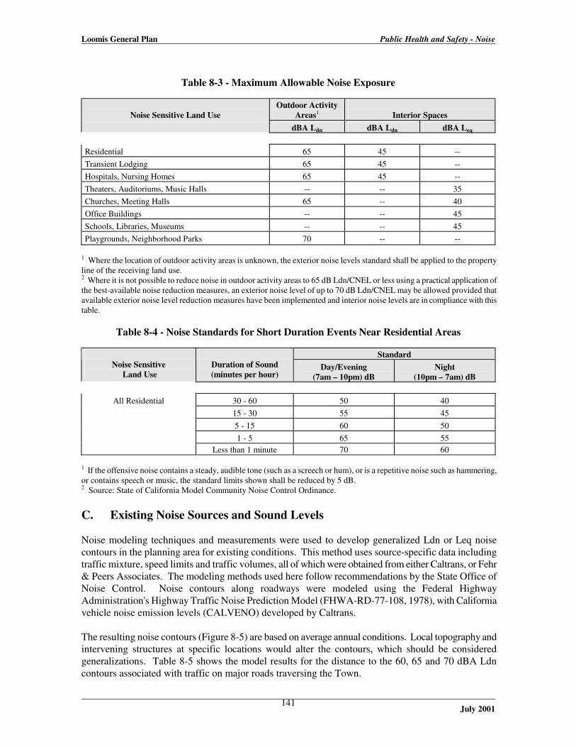
Loomis General Plan Public Health and Safety - Noise
July 2001
141
Table 8-3 - Maximum Allowable Noise Exposure
Noise Sensitive Land Use
Outdoor Activity
Areas1
Interior Spaces
dBA Ldn
dBA Ldn
dBA Leq
Residential
65
45
--
Transient Lodging
65
45
-- Hospitals, Nursing Homes
65
45
--
Theaters, Auditoriums, Music Halls
--
--
35 Churches, Meeting Halls
65
--
40
Office Buildings
--
--
45 Schools, Libraries, Museums
--
--
45
Playgrounds, Neighborhood Parks
70
--
-- 1 Where the location of outdoor activity areas is unknown, the exterior noise levels standard shall be applied to the property line of the receiving land use. 2 Where it is not possible to reduce noise in outdoor activity areas to 65 dB Ldn/CNEL or less using a practical application of the best-available noise reduction measures, an exterior noise level of up to 70 dB Ldn/CNEL may be allowed provided that available exterior noise level reduction measures have been implemented and interior noise levels are in compliance with this table.
Table 8-4 - Noise Standards for Short Duration Events Near Residential Areas
Standard
Noise Sensitive
Land Use
Duration of Sound (minutes per hour)
Day/Evening
(7am – 10pm) dB
Night
(10pm – 7am) dB
30 - 60
50
40 15 - 30
55
45
5 - 15
60
50 1 - 5
65
55
All Residential
Less than 1 minute
70
60
1 If the offensive noise contains a steady, audible tone (such as a screech or hum), or is a repetitive noise such as hammering, or contains speech or music, the standard limits shown shall be reduced by 5 dB. 2 Source: State of California Model Community Noise Control Ordinance. C. Existing Noise Sources and Sound Levels Noise modeling techniques and measurements were used to develop generalized Ldn or Leq noise contours in the planning area for existing conditions. This method uses source-specific data including traffic mixture, speed limits and traffic volumes, all of which were obtained from either Caltrans, or Fehr & Peers Associates. The modeling methods used here follow recommendations by the State Office of Noise Control. Noise contours along roadways were modeled using the Federal Highway Administration's Highway Traffic Noise Prediction Model (FHWA-RD-77-108, 1978), with California vehicle noise emission levels (CALVENO) developed by Caltrans. The resulting noise contours (Figure 8-5) are based on average annual conditions. Local topography and intervening structures at specific locations would alter the contours, which should be considered generalizations. Table 8-5 shows the model results for the distance to the 60, 65 and 70 dBA Ldn contours associated with traffic on major roads traversing the Town.

Loomis General Plan Public Health and Safety - Noise
July 2001
142
Table 8-6 serves as a guide when applying traffic noise exposure contour information to areas with varying topography. The table is used by adding the correction factor to the predicted noise level for a given location. The factors included in this table present conservative (worst-case) results, and complex situations should be evaluated by an acoustical consultant when the potential for a significant noise impact exists. · Roadways. Roadway traffic is the primary source of noise in the Loomis community. Interstate
80 carries by far the most traffic through the area, and is consequently the major noise contributor. The 60 dBA Ldn contour from I-80 ranges from 1,650 to 1,750 feet from centerline. However, this distance is likely much less than modeled, because of topographic attenuation (see Table 8-6) and intervening buildings.
Taylor Road and Sierra College Boulevard are the only other roadways that carry sufficient traffic to produce audible noise at a significant distance. The 60 dBA Ldn contour for these roads typically ranges from 200 to 400 feet, and less where there are intervening structures. Horseshoe Bar Road, King Road and Rocklin Road carry moderate traffic (4,000-5,000 ADT), but not enough to produce far-reaching noise contours. The noise model predicts that the 60 dBA Ldn contour would be less than 100 feet from the center of those roadways. Figure 8-5 and Table 8-5 provide more detailed information.
Table 8-5 - Existing Traffic Noise Levels
Distance to Ldn Contour from Centerline (feet)
Roadway Segment
Traffic (ADT) 70 dB 65 dB 60 dB
Interstate 80 Sierra College Blvd. to Horseshoe Bar Rd.
84,000 379 816 1,757
Interstate 80 Horseshoe Bar Rd. to Penryn exit
78,000
360
776
1,672
Sierra College Boulevard Interstate 80 to Taylor Road
12,300
84
181
390
Sierra College Boulevard Taylor Road to Bankhead Road
9,300
70
150
324
Sierra College Boulevard n/o King Road
6,100
53
113
244
Taylor Road e/o Sierra College Blvd.
10,500
58
126
271
Taylor Road s/o King Road
13,800
51
110
238
Horseshoe Bar Road Interstate 80 to Brace Road
5,300
-
40
86
King Road w/o Swetzer Road
5,300
-
40
86
Rocklin Road w/o Barton Road
4,500
-
36
77
Barton Road n/o Rocklin Road
1,700
-
-
40
Laird Road s/o High Cliff Road
1,900
-
-
44
Source: Traffic

Loomis General Plan Public Health and Safety - Noise
July 2001
143
volumes from Caltrans and Fehr & Peers (1998).
Table 8-6 - Traffic Noise Adjustments for Topography
Distance from Roadway Centerline (feet)
Topographic Situation <200 200-400 >400 Hillside overlooks roadway
no change
+1 dB
+3 dB
Roadway Elevated (>15 feet)
-5 dB
-2 dB
no change Roadway in cut/below embankment
-5 dB
-5 dB
-5 dB
Dense vegetation (100 feet or more thick)
-5 dB
-5 dB
-5 dB Source: Brown-Buntin Associates, Inc., 1994.
Field measurements were taken adjacent to each of the roadways shown in Table 8-5 as a means of verifying the modeled noise levels. (1) These 20-minute samples were taken at distances varying from 50 to 100 feet from the roadway centerlines where possible, during a typical weekday non-peak afternoon period. In general, there was some variation from the FHWA model, but typically less than 10 percent (see model runs in attached appendix). This variation can be accounted for by several factors, including the duration of field samples, the time of day that measurements were taken, and the day of the week of sampling. Other variables that might have affected field measurements include the weather, which could affect the expected traffic volumes. In general, the field measurements verified the predicted noise levels along community roadways.
· Rail Traffic. The Union Pacific Railroad operates two rail lines through the Town. The
westbound rail line parallels Taylor Road, and cuts through the center of the community. The eastbound line travels northward, along the western edge of the planning area, about 1.5 miles west of downtown Loomis.
Noise measurements were conducted on both lines to determine the contribution of freight and passenger rail operations to the noise environment. The goal of the noise measurements was to determine the typical sound exposure levels (SEL), accounting for travel speed, warning horns, locomotive noise, and other factors contributing to noise generation. The average SEL for the four observed freight trains was 108.7 dB at a distance of 100 feet from the track centerline; for the two passenger trains, the average SEL was 94 dB. Measurements were taken for trains
1 Existing noise conditions were measured through noise monitoring using an ANSI Type II sound level meter (Larson Davis 720). Sound levels were recorded on November 9, 1999 along the roadways shown in Table 8-5. Noise monitoring at rail and industrial facilities was conducted with the same equipment.

Loomis General Plan Public Health and Safety - Noise
July 2001
144
moving in both directions, and taken near roadway crossings (Boulder Ridge Road, west of Del Mar Avenue; and Webb Street, south of King Road) where train whistles were blown.
According to Union Pacific officials, the number of trains traveling through Loomis fluctuates, but typically includes 8 to 14 trains per day (Union Pacific, 2000). This number is consistent with a 1996 Surface Transportation Board ruling that limits the number of trains passing through Reno, Nevada, to 15 as a condition of the recent Union Pacific/Southern Pacific merger (Mike Furtney, Union Pacific, 1998). For the purpose of this analysis, the worst case (14 trains) is assumed, evenly distributed between east and westbound freight. The analysis also assumes that each train is pulled by an average of 3 to 4 engines, and carries an average of about 100 cars. About half the trains traverse the community at night, with whistles blown at all at-grade crossings. The average train speed is estimated to be about 50 miles per hour.
Amtrak operates two eastbound and two westbound passenger trains daily that pass through Loomis. All four passenger trains pass through the Town during the day or early evening.
To determine the distance to noise contours, it is necessary to calculate the Ldn for typical rail operations. This is accomplished by using the recorded SEL values and the known number of trains. The Ldn may be calculated as follows:
Ldn = SEL + 10logN – 49.4 dB, where:
SEL is the mean SEL of the event, N is the sum of the number of day and evening trains per day plus 10 times the number of nighttime (10pm to 7 am) trains per day, and 49.4 is ten times the logarithm of the number of seconds per day. Based on this information, the calculated noise contour distances from each rail line are shown in Table 8-7. These contours are depicted graphically in Figure 8-5. It should be noted that nearly all of the rail noise is a result of freight traffic. The amount of noise contributed by passenger trains is considered negligible.
Table 8-7 - Approximate Distance to Existing Rail Noise Contours
Distance to Ldn contour (feet) Train Source
Recorded SEL
Ldn, at 100 feet
70
65
60
Union Pacific (freight)
108.7
75.2
-
-
-
Amtrak (passenger)
94.0
47.6
-
-
- Combined Ldn
n/a
75.2
223
480
1,035
Assumes 7 freight and 2 passenger trains in each direction daily. 3.5 freight and no passenger trains at night. SEL recorded with noise meter at crossings at Boulder Ridge Road and Webb Street, with each train blowing its whistle during the crossing.
· Stationary Noise Sources. Industrial and commercial operations can be significant sources of
noise, depending on the type and hours of operation. Stationary noise sources of concern typically include generators, pumps, air compressors, outdoor speakers, motors, heavy equipment and similar machinery. These are usually often associated with trucking companies, tire shops, auto mechanic shops, metal shops, shopping centers, drive-up windows, car washes, loading docks, gravel operations, athletic fields, and electric generating stations.

Loomis General Plan Public Health and Safety - Noise
July 2001
145
Industrial Operations. In Loomis, loading docks are the most commonly cited stationary noise nuisance. Brown-Buntin Associates estimated that typical loading dock operations generate a noise level of 60 dB Leq at a distance of 50 feet for a busy one-hour period (ESA, Turtle Island Draft EIR, 1996). This noise level includes tractor-trailer truck traffic arriving, departing and idling.
Many facilities of this type exist in Loomis, particularly within heavy commercial or industrial areas west of Taylor Road, particularly north of King Road. Areas where residential uses abut industrial uses are particularly susceptible to loading dock noise. The most prominent examples of this in Loomis include the homes along Kathy Way, which are located just west of an extensive industrial area, and homes near Brace Road, between Interstate 80 and Sierra College Boulevard. A 1999 acoustical study for a proposed industrial facility at the corner of Swetzer Road and Jetton Lane concluded that the primary sources of noise would be loading operations and associated truck traffic (Western Planning and Engineering, 1999). Such operations (usually about 20 minutes in duration, occurring infrequently throughout the day) would produce an Leq of 50 dBA within 150 feet of the operations. Noise resulting from operations within such a facility would have a lesser impact on neighboring areas. It should be noted that noise at individual facilities can vary greatly depending on the nature of the facility. It is not possible to characterize all facilities based on what is experienced at a few locations. Unlike roadway noise, which is a continuous noise source that can be accurately modeled, it is not possible to develop meaningful noise contours that could provide useful planning tools in the context of a Noise Element. Instead, it is more appropriate to identify areas where such facilities either currently exist or are likely to in the future. Generally speaking, these areas include land designated for industrial uses, typically near residential areas. The standards shown in Table 8-4 (which address short-term noise events) should be used to determine the compatibility between individual facilities and nearby homes. Please refer to Figure 8-5 for the location of where such standards are most appropriately employed. Noise Monitoring. Additional noise monitoring was conducted in February 2000 at several locations near other industrial facilities in the community, including the lumber manufacturing plant along Taylor Road and at several locations along Swetzer Road. Noise monitoring was conducted as far as possible from the roadways themselves, owing to the limitations of the site. Typically, monitoring stations were from 50 to 150 feet from the nearest roadways. In general, ambient roadway noise dominated the measurements, particularly for locations along Taylor Road, particularly near Interstate 80. Swetzer Road carries substantially less traffic than either Taylor Road or Interstate 80, and thus noise reading along that roadway provide a generally better reflection of adjacent industrial activities. However, a Union Pacific rail line runs parallel to Swetzer Road. Although no trains passed during noise sampling, it is reasonable to conclude that passing trains would dominate the noise environment at this location. In general, the results of noise monitoring at industrial locations were inconclusive. Truck activity associated with industrial operations appeared to be the greatest contributing factor to the noise environment. Ambient noise levels of 50 to 55 dBA Leq were recorded at all locations along Swetzer Road. Along Taylor Road, ambient noise levels were typically 60-65 dBA Leq. The variation can in part be accounted for local conditions, the varying proximity of monitoring locations to roadways, and activities on the sites. No unusual noise sources were noted or

Loomis General Plan Public Health and Safety - Noise
July 2001
146
recorded during monitoring activities. Truck activities at each site, including braking and horn noises, appeared to be the primary contributors to the onsite noise environment. It should be noted that the Town cannot reasonably model or characterize all industrial facilities in the community within the context of the Noise Element. There is too much variation from site to site to provide a meaningful analysis of this issue. Instead, the Noise Element provides the direction for the locations where detailed acoustical studies should be conducted (see Figure 8-5). The following paragraphs present the results of other noise studies at industrial facilities, intended in part to corroborate the information presented for facilities in Loomis.
Corroborative Studies. In other detailed studies conducted for industrial facilities near major roadways, the results have been similar. For example, continuous noise sampling was conducted over a two-day period for a 1999 study of an equipment rental yard near U.S. 101 in Ventura County (Quinn Noise Study, Rincon Consultants, 1999). That study found that the ambient hourly Leq was relatively stable during the daytime hours of 6:00 am to 7:00 pm, ranging from 65.3 to 67.1 dBA. Sound levels gradually dropped during the evening hours from a high of 64.6 dBA during the 7:00 pm hour to 63.2 in the 9:00 pm hour, and continued to drop during the nighttime hours to a low of 57.0 dBA during the 3:00 am hour. This is similar to what might be experienced within several hundred feet of Interstate 80 in Loomis.
The noise generation of concern at most industrial facilities is the loading of and pass-by through of heavy equipment delivery trucks. In the Quinn study, measurements of a typical heavy-duty truck that would be used as a delivery vehicle showed the sound level during idling was 70.3 dBA at 25 feet from the centerline of the source, dropping to about 58 dBA at 100 feet from the source. This is less than the ambient background noise levels at the Quinn site location, which suggests roadway noise was a greater concern than industrial noise. That study presents a similar condition to what might be expected at industrial facilities near Taylor Road or Interstate 80.
Other Stationary Noise Sources. Several other facilities in the community may also present stationary noise. Such facilities include dog kennels, commercial operations, high school football games, and other public gathering involving music or loudspeakers. A 1999 acoustical study for a proposed dog kennel at 3994 Del Mar Avenue found barking dogs at that facility would produce a noise level of about 51.5 dB at the nearest residence (a distance of about 400 feet). Based on the standards shown in Table 8-4, dog barking at this location was found to exceed the 50 dB standard, and mitigation was recommended (1-5 minute duration, with a 5 dB penalty for the repetitive quality of the barking). Other dog kennels in the community would likely have similar noise characteristics. However, because of flexibility in land use controls, it is impossible to predict where other kennels may locate in the future. Thus, it is impossible to produce meaningful noise contours for this activity. High school football games and other activities (such as band practice) are occasionally staged at the Del Oro High School football stadium. The most adverse noise impacts are experienced during the fall months because of football season. Because events generally occur in the evening, between 7:00 pm and midnight, and attract large crowds, the impacts from this type of event are expected to be significant. Noise could be generated during these events from multiple sources at varying degrees throughout the season and throughout the duration of each event. Examples of these sources include crowd participation, music being played by the band, air horns and the announcement of the event over the loud speaker.

Loomis General Plan Public Health and Safety - Noise
July 2001
147
To estimate the noise impacts of a stadium in the area, a noise survey was conducted by Brown-Buntin and Associates, in 1988 and 1992, at three high school stadiums in Bakersfield. The measurements were taken at a distance of 400 feet from the center of the stadium. Table 8-8 shows the average noise levels from the three Bakersfield stadiums at the reference distance of 400 feet. All of the stadiums had playing fields at the same elevation as the surrounding ground with bleachers. An assumption that there is a 6 dB reduction for every doubling of distance from a point source of noise was made and this information was interpreted to establish the noise contour lines for the stadium. Based on this data, Table 8-9 shows the estimated noise contours around the stadium. In general, only residential areas within 537 feet of the stadium experience noise levels that exceed the Town’s 60 dBA Ldn standard.
Table 8-8 - Reference Noise Levels At 400 Feet From
Typical Football Stadiums
Leq L50 L25 L1.7 Lmax
63 61 64 71 75 Source: Brown-Buntin Associates, Inc.; measurements near West High School, Bakersfield High School, and Garces High School stadiums, 1988, 1992, as cited in DEIR New Ceres High School Site Acquisition and Development Project, Michael Paoli and Associates.
Table 8-9 - Estimated Distance to Noise Contours of
Del Oro High School Football Stadium
Daily Noise Level (Ldn) Distance
Ldn – 60 dBA 537 feet
Ldn – 55 dBA 950 feet
Modeled, based on 63 dBA Leq cited in the previous table. · Sensitive Receptors. Noise exposure goals for various types of land uses reflect the varying
noise sensitivities associated with those uses. Residences, hospitals, schools, guest lodging, libraries, churches and parks are most sensitive to noise intrusion and therefore have more stringent noise exposure targets than manufacturing or agricultural uses that are not subject to such impacts as sleep disturbance.
The relative sensitivity of various land uses is illustrated in the state’s noise compatibility guidelines, shown previously in Figure 8-4. Community Noise Survey. Appendix A of the Guidelines For the Preparation and Content of the Noise Element of the General Plan requests that a community noise survey be included as part of the element. The Guidelines do not specify the form of the survey. Typically, when a “survey” is included in a Noise Element, it generally means that the existing noise environment of the community has been characterized in broad terms. Sample noise measurements for the various noise sources affecting a community also help fulfill the intent of the community noise survey. In this Noise Element, noise measurements have been conducted for road, rail and stationary noise sources as discussed in previous portions of this element.

Loomis General Plan Public Health and Safety - Noise
July 2001
148
In addition, a Noise Element can contain a brief record of recent complaints or known noise nuisances that affect the community. In general, the primary noise issues cited by the community in workshops for the General Plan update are Interstate 80 and the rail lines (see the Background Technical Report). Industrial and other stationary noise sources have historically been cited by community members, typically through occasional complaints to the Town. As a recent example, an acoustical analysis was performed for a proposed expansion of a dog kennel (All Pets Boarding Kennels) on Del Mar Avenue, in part because of community concerns. Other acoustical analyses for various facilities have been performed for similar reasons. Industrial facilities that have been noted by various members of the community as potential noise concerns include the Pool Diggers Excavation Company (3348 Swetzer Court) and the proposed PrePlastics facility at the corner of Swetzer Road and Jetton Lane. In general, the industrial facilities along the Swetzer Road area have been noted as a potential noise source by the community. Similarly, some of the older industrial facilities along Taylor Road, including the lumber manufacturing plant along that roadway, have been noted as community concerns.
D. Future Noise Levels Future noise levels in the community are based on an anticipated increase of traffic and rail operations, as well as industrial noise or nuisance noise that may result from land development in the community. Traffic increases may be predicted based on cumulative buildout of the Town and surrounding communities. Please refer to the Circulation Element for this information. Increases in rail operations are based on communication with rail officials at Union Pacific and Amtrak. Future industrial-related noise would be more difficult to predict, because not all industrial uses produce substantial noise. In some cases, non-industrial uses could produce nuisance noise that could affect nearby noise-sensitive uses, typically homes. The likely noise levels from each noise source is discussed below. · Roadways. Continued land development in Loomis and neighboring communities will result in
traffic increases on major roadways. Such increases will result in increased noise levels on area roadways. As is currently the case, Interstate 80 would be by far the greatest contributor to overall roadway noise in the community. However, much of this increase may be attributed to future development outside the community, especially in the cases of Interstate 80 and Sierra College Boulevard. Assuming no barrier attenuation, areas within about 0.4 miles of the freeway would be subject to noise levels in excess of 60 dBA Ldn without mitigation. Areas within about 0.2 miles of Sierra College Boulevard would also be subject to noise levels that exceed the adopted standard. Table 8-10 and Figure 8-5 show projected noise levels and contours within the Town, based on projected buildout under the Land Use Element.
· Rail traffic. The Union Pacific Railroad currently has no plans for expanding its existing
facilities. However, the number of rail operations is likely to increase. Based on recent input from Union Pacific officials, by 2020 the number of daily train operations are anticipated to increase from the current 8 to 14 trains to as many as 14 to 24. About 5 to 8 of these trains (roughly one-third) would operate during nighttime hours (10pm to 7am). This analysis assumes the worst case, that is 24 trains, with 8 at night, or 12 trains (4 at night) in each direction. The composition of future trains would be similar to what currently exists, about 3 to 4 engines with an average of 100 freight cars. Because the composition of freight trains would remain similar to existing trains, measured SEL for existing trains can be used to estimate future noise levels along rail lines.
Amtrak has not indicated any expanded service plans for this rail corridor. However, to account for a possible expansion of passenger train service, this analysis assumes that two additional

Loomis General Plan Public Health and Safety - Noise
July 2001
149
trains may use the rail line, one of which could operate at night. This would bring the total number of operations to six trains (three in each direction), five of which would pass through the Town during the day or early evening.

Loomis General Plan Public Health and Safety - Noise
July 2001
150
Table 8-10 - Projected Traffic Noise Levels at Regional Cumulative Buildout
Distance to Ldn Contour from Centerline (feet)
Roadway Segment
Traffic (ADT) 70 dB 65 dB 60 dB
Interstate 80 Sierra College Blvd to Horseshoe Bar Rd. 132,000 512 1,102 2,375 Interstate 80 Horseshoe Bar Rd. to Penryn exit
119,900
480
1,034
2,227
Sierra College Boulevard Interstate 80 to Taylor Road
47,300
206
444
957
Sierra College Boulevard Taylor Road to Bankhead Road
34,800
168
362
780
Sierra College Boulevard n/o King Road
24,900
134
290
624
Sierra College Boulevard Bankhead Road to King Road
18,700
111
239
516
Taylor Road e/o Sierra College Blvd.
23,100
99
213
458
Taylor Road s/o King Road
17,800
61
131
282
Taylor Road e/o King Road
11,700
46
99
213
Horseshoe Bar Road Interstate 80 to Brace Road
17,000
40
87
188
King Road w/o Swetzer Road
12,000
32
69
149
Rocklin Road w/o Barton Road
18,300
42
92
197
Barton Road n/o Rocklin Road
7,200
-
49
106 Laird Road s/o High Cliff Road
4,800
-
38
81
Source: Projected traffic volumes from Caltrans and Fehr & Peers (1999); see Appendix for model runs. Includes the effects of regional cumulative development in neighboring communities.

Loomis General Plan Public Health and Safety - Noise
July 2001
151
Based on the methodology to calculate existing rail noise, the calculated future noise contour distances from each rail line are shown in Table 8-11. These contours are depicted graphically in Figure 8-5. It should be noted that nearly all of the rail noise will be a result of freight traffic. The noise contributed by passenger trains is considered negligible.
It should also be noted that a substantial noise increase is not anticipated, even though the number of future operations is expected to increase substantially. This is because the number of nighttime operations is not expected to increase significantly over existing numbers. Nighttime operations are heavily weighted in the calculation of rail noise levels.
Table 8-11 - Approximate Distance to Future Rail Noise Contours
Distance to Ldn contour (feet) Train Source
Recorded
SEL
Ldn, at 100
feet
70
65
60 Union Pacific (freight)
108.7
76.1
-
-
-
Amtrak (passenger)
94.0
55.7
-
-
- Combined Ldn
n/a
76.1
256
551
1,186
Assumes 12 freight and 3 passenger trains in each direction daily. 4 freight and 1 passenger trains at night. SEL recorded with noise meter at crossings at Boulder Ridge Road and Webb Street, with each train blowing its whistle during the crossing.
· Stationary Noise Sources. Future stationary noise sources in the community are likely to be
similar to those that already exist. The updated General Plan would likely accommodate additional industrial or commercial activities that could result in an increase in stationary source noise activity. However, it is impossible to predict the magnitude and specific location of potential noise conflicts associated with future development. Instead, the Noise Element can only note where future noise conflicts may occur, based on the proposed Land Use diagram. Such areas are highlighted on Figure 8-5, and are briefly listed below: 1. Residential/Industrial interface, between Swetzer Road and Arcadia Avenue; 2. Residential/Commercial/Industrial interface along Taylor Road, north of King Road; 3. Residential/Commercial interface south of Laird Street and David Avenue, north of I-80; 4. Residential/Commercial interface near Sierra College Boulevard, north of Taylor; and 5. Residential/Commercial interface along Brace Road and Secret Ravine Creek. These areas are likely to experience noise conflicts as development occurs. Other localized areas of potential noise conflict may also exist, if there are non-conforming industrial uses near residential development. Development in all such areas, particularly those listed above, is subject to compliance with noise standards shown in both Tables 8-3 and 8-4, which address average daily noise levels and noise events of a shorter duration.
It is not possible to project future stationary source noise levels associated with new development in these areas. Unlike roadway noise, which is a continuous noise source that can be accurately modeled, it is not possible to develop meaningful noise contours that could provide useful planning tools in the context of a Noise Element.

Loomis General Plan Public Health and Safety - Noise
July 2001
152

Loomis General Plan Public Health and Safety - Noise
July 2001
153
E. Issues, Goals, Policies, and Implementation Measures Issues · Increased volumes of local and commuter traffic on Town arterial roadways and rail corridors
create noise impacting residential frontage properties. Goals 1. To protect Town residents and workers from the harmful and annoying effects of noise. 2. To mitigate the effects of noise created by roadway traffic and non-residential land uses while
discouraging the construction of sound walls. 3. To maintain and where possible enhance the quiet, rural ambiance of the Town. 4. To minimize the noise effect of railroad operations on residential uses and other sensitive land
uses. Policies 1. New commercial and industrial development in the Town shall be sited and designed to minimize
the potential for harmful or annoying noise to create conflict with existing land uses. 2. Loomis shall encourage the mitigation of noise impacts in all new developments as necessary to
maintain the quiet, rural ambiance of the Town. 3. An acoustical analysis shall be required for new residential structures located within the projected
noise contour of 65 dBA Ldn, showing that the structures have been designed to limit intruding noise in interior rooms to an annual level of 45 dBA Ldn.
4. Individual noise exposure analysis shall be required for proposed development projects as part of
the environmental review process, to ensure that the Town's noise standards are meet. The use of mitigation measures (noise buffers, sound insulation) may be required to reduce noise impacts to acceptable levels.
5. Loomis shall discourage the construction of sound walls to mitigate noise impacts, unless it is the
only feasible alternative. New sensitive noise receptors shall not be permitted if the only feasible mitigation for noise impacts is a sound wall.
6. Where noise mitigation is necessary, the following order of preference among options shall be
considered: distance from the noise source; muffling of the noise source; design and orientation of the receptor; landscaped berms; landscaped berms in combination with walls.
7. Use the land use/noise compatibility matrix shown on Figure 8-4 to determine the appropriate
ness of land uses relative to roadway noise. 8. Work with Caltrans to install mitigation elements along freeways and highways adjacent to
existing residential subdivisions or noise-sensitive uses to reduce noise impacts.

Loomis General Plan Public Health and Safety - Noise
July 2001
154
9. Provide for alternative transportation modes such as bicycle paths and pedestrian walkways to minimize the number of automobile trips.
10. Require that new equipment and vehicles purchased by the Town comply with noise performance standards consistent with the best available noise reduction technology.
11. Work with public transit agencies to ensure that the buses, vans, and other vehicles used do not
generate excessive noise levels.
12. Consider the use of rubberized asphalt paving material for future road paving and re-paving. Studies have indicated that such paving material can result in a 3 to 5 dBA reduction in noise.
13. Consider the use of traffic calming devices to reduce traffic noise in residential areas, when supported by the residential community in question.
14. Work with the Union Pacific Railroad to properly maintain lines and establish operational
restrictions during the early morning and late evening hours to reduce impacts in residential areas and other noise sensitive areas.
15. Require that automobile and truck access to industrial and commercial properties adjacent to
residential areas be located at the maximum practical distance from the residential area.
16. Require that when no other feasible location for industrial or commercial use parking exists other than adjacent to residential uses, the parking shall be buffered from the residential uses by barriers.
17. Limit the use of leaf blowers, motorized lawn mowers, parking lot sweepers, or other high-noise equipment on commercial properties if their activity will result in noise which adversely affects residential areas.
18. Require that the hours of truck deliveries to industrial and commercial properties adjacent to residential uses be limited to daytime hours unless there is no feasible alternative or there are overriding transportation benefits by scheduling deliveries at night.
19. Require that construction activities adjacent to residential units be limited as necessary to prevent adverse noise impacts.
20. Future industrial or commercial development in areas determined to be near noise-sensitive land
uses shall be subject to an acoustical analysis to determine the potential for stationary source noise impacts to neighboring land uses.
Implementation Measures 1. Establish exterior land use noise compatibility standards in the Zoning Ordinance for all new
development based on the guidelines shown on Figure 8-4 and Table 8-3 of this Element.
2. Incorporate in the Zoning Ordinance requirements that limit maximum interior levels to 45 dBA Ldn in all new residential construction.

Loomis General Plan Public Health and Safety - Noise
July 2001
155
3. For new development within the generalized 65 dBA Ldn noise contour as shown in Figure 8-5 of this Element, project applicants shall fund site-specific noise studies to mitigate project impacts. The determination of whether a project site is within the 65 dBA Ldn contour is the responsibility of the Planning Department. The required noise analysis shall: a. Include field measurements by a qualified environmental scientist/acoustical engineer to
determine a more precise location of existing and projected future noise levels (based on traffic projections included in the Circulation Element or as accepted by the Town); and
b. Identify and commit to measures to mitigate noise impacts (by siting of structure outside of high noise levels, insulation, attenuation, walls or buffers, landscape, or other acceptable techniques) if within the 65 dBA contour.
4. When development is subject to high noise levels requiring mitigation, the following measures
shall be considered and preference shall be given where feasible in the following order: a. Site layout, including setbacks, open space separation and shielding of noise sensitive uses
with non-noise-sensitive uses. b. Acoustical treatment of buildings. c. Structural measures: construction of earthen berms and/or wood or concrete barriers.
5. Incorporate into the Zoning Ordinance standards that protect inhabitants from impacts of exterior
noise, prevent the transference of interior noise to the outside, prevent transference of noise between residential units and individual businesses in multi-tenant buildings, and prevent transference of noise between commercial and residential uses in mixed structures. Standards for insulation, windows, building materials, walls and roofs shall be included.
6. Include in the Zoning Ordinance standards and requirements for parking structures and lots to prevent noise effects on-site and on adjacent noise sensitive uses. These could include the use of buffers containing landscape and/or sound walls, use of sound absorbing materials to minimize sound amplification and transmission, enclosure of the façade of parking structures facing a residence, limitation of the hours of operation of surrounding surface parking lots, and other appropriate techniques.
7. The Town shall review development proposals according to their potential noise impacts on
abutting uses and impacts by abutting uses in accordance with the standards and requirements stipulated by this Element and incorporated into the Zoning Ordinance.
8. The Town shall consider the use of temporary noise barriers, limited hours of operation, limiting
times of year for construction near schools to reduce construction-related noise. 9. The Town shall review the street layout of proposed residential subdivisions with the objective of
reducing traffic volumes and through trips as a means to reduce noise levels. The use of road dips, diagonal parking, one-way streets, and other traffic controls and traffic calming devices shall be considered to reduce vehicular travel and speed, provided that engineering and safety standards are met. If determined to be feasible, rubberized asphalt paving material may be required for new roads.
10. Speed limits are legally set in accordance with the prevailing speed of traffic based on
engineering studies. However, when feasible, consistent and necessary, the reduction of speed limits on arterials should be used to decrease ambient noise levels.

Loomis General Plan Public Health and Safety - Noise
July 2001
156
11. The Town shall evaluate the noise impacts of vehicles on adjacent residential properties as a part of the development and environmental review process for all commercial and manufacturing uses. Where vehicles would have the potential to create noise exceeding 60 dBA Ldn at an adjacent noise sensitive use, the inclusion of noise mitigation techniques such as the use of sound wall or enclosure of delivery areas shall be required.
12. To reduce noise associated with truck traffic, the Town shall implement the following noise
reduction strategies: a. The Town and Caltrans should consider limitations on hours of operation and other truck
operations that could be limited to reduce noise impacts. b. The Town should encourage the use of established designated truck routes that avoid
residential areas and confine truck traffic to major thoroughfares. Designated truck routes must be followed.
c. The Town shall post designated areas and times to prohibit the use of jake brakes along established truck routes adjacent to sensitive uses.
13. Support the efforts of the California Department of Transportation and local transportation
agencies in developing noise reduction measures for Interstate 80, including sound barrier walls, if no feasible alternatives exist.
14. Maintain a data file documenting existing and future noise conditions, using the contour map
contained in this Plan. As noise assessments are conducted for proposed projects or other noise studies are performed, the data base shall be updated. The noise data shall be updated entirely at least once every five years.
15. Work with railroad operators to determine when noise controls may be necessary due to the
adjacency of railroad lines to residential uses. 16. The Town shall enforce the State Noise Insulation Standards (California Code of Regulations,
Title 24) and Chapter 35 of the Uniform Building Code (UBC). 17. Future industrial or commercial development in areas determined to be near noise-sensitive land
uses, as shown in Figure 8-4, shall be subject to an acoustical analysis at the discretion of the Planning Director, to determine the potential for stationary source noise impacts to neighboring land uses.
18. Where noise-sensitive land uses are proposed in areas exposed to existing or projected noise
levels in excessive of the standards contained in Tables 8-3 and 8-4. The Town shall require an acoustical analysis as part of the environmental review process so that noise mitigation may be included in the project design. At the discretion of the Planning Director, the requirement for an acoustical analysis may be waived if all of the following conditions are satisfied:
a. The development is for less than five single-family dwellings or less than 10,000 square
feet of total gross floor area for office buildings, churches, or meeting halls; b. The noise source in question consists of a single roadway or railroad for which up-to-date
noise exposure information is available. An acoustical analysis will be required if the noise source is a stationary noise source, or if there are multiple noise sources that could affect the project;
Loomis General Plan Public Health and Safety - Noise
July 2001
157
c. The projected future noise exposure at the exterior of proposed buildings or outdoor activity areas does not exceed 65 dBA Ldn;
d. The topography of the area is essentially flat; and e. Effective noise mitigation, as determined by the Planning Director, is incorporated into the
project design. Such measures can include, but are not limited to, the use of building setbacks, building orientation, noise barriers. If closed windows are required for compliance with interior noise level standards, air conditioning or a mechanical ventilation system will be required.
19. The Town shall develop standards for acceptable nuisance noise levels for both day and night.

Loomis General Plan Glossary
July 2001
158
Glossary Abbreviations ADT: Average daily trips made by vehicles or persons in a 24-hour period CC&Rs: Covenants, Conditions, and Restrictions CDBG: Community Development Block Grant CEQA: California Environmental Quality Act CIP: Capital Improvements Program CNEL: Community Noise Equivalent Level COG: Council of Governments dB: Decibel dBA: "A-weighted" decibel EIR: Environmental Impact Report (State) EIS: Environmental Impact Statement (Federal) FAR: Floor Area Ratio FEMA: Federal Emergency Management Agency FHWA: Federal Highway Administration FIRM: Flood Insurance Rate Map FmHA: Farmers Home Administration HCD: Housing and Community Development Department of the State of California HOV: High Occupancy Vehicle HUD: U.S. Dept. of Housing and Urban Development JPA: Joint Powers Authority LAFCo: Local Agency Formation Commission Ldn: Day and Night Average Sound Level Leq: Sound Energy Equivalent Level LOS: Level of Service NEPA: National Environmental Policy Act OPR: Office of Planning and Research, State of California PUD: Planned Unit Development TDM: Transportation Demand Management TDR: Transfer of Development Rights TSM: Transportation Systems Management UBC: Uniform Building Code UHC: Uniform Housing Code VMT: Vehicle Miles Traveled Definitions of Specialized Terms and Phrases Acceptable Risk. A hazard deemed to be a tolerable exposure to danger given the expected benefits to be obtained. Different levels of acceptable risk may be assigned according to the potential danger and the criticalness of the threatened structure. The levels may range from "near zero" for nuclear plants and natural gas transmission lines to "moderate" for open space, ranches and low-intensity warehouse uses. Access/Egress. The ability to enter a site from a roadway and exit a site onto a roadway by motorized vehicle. Acres, Gross. The entire acreage of a site. Most communities calculate gross acreage to the centerline of proposed bounding streets and to the edge of the right-of-way of existing or dedicated streets. Acres, Net. The portion of a site that can actually be built upon. The following generally are not included in the net acreage of a site: public or private road rights-of-way, public open space, and flood ways. Adverse Impact. A negative consequence for the physical, social, or economic environment resulting from an action or project.

Loomis General Plan Glossary
July 2001
159
Affordability Requirements. Provisions established by a public agency to require that a specific percentage of housing units in a project or development remain affordable to very low- and low- income households for a specified period. Affordable Housing. Housing capable of being purchased or rented by a household with very low, low, or moderate income, based on a household's ability to make monthly payments necessary to obtain housing. Housing is considered affordable when a household pays less than 30 percent of its gross monthly income (GMI) for housing including utilities. Agency. The governmental entity, department, office, or administrative unit responsible for carrying out regulations. Agricultural Preserve. Land designated for agriculture or conservation. (See "Williamson Act.") Agriculture. Use of land for the production of food and fiber, including the growing of crops and/or the grazing of animals on natural prime or improved pasture land. Agriculture-related Business. Feed mills, dairy supplies, poultry processing, creameries, auction yards, veterinarians and other businesses supporting local agriculture. Air Pollution. Concentrations of substances found in the atmosphere that exceed naturally occurring quantities and are undesirable or harmful in some way. Alley. A narrow service way, either public or private, which provides a permanently reserved but secondary means of public access not intended for general traffic circulation. Alleys typically are located along rear property lines. Alluvial. Soils deposited by stream action. Alquist-Priolo Act, Seismic Hazard Zone. A seismic hazard zone designated by the State of California within which specialized geologic investigations must be prepared prior to approval of certain new development. Ambient. Surrounding on all sides; used to describe measurements of existing conditions with respect to traffic, noise, air and other environments. Annex. To incorporate a land area into an existing district or municipality, with a resulting change in the boundaries of the annexing jurisdiction. Apartment. (1) One or more rooms of a building used as a place to live, in a building containing at least one other unit used for the same purpose. (2) A separate suite, not owner occupied, which includes kitchen facilities and is designed for and rented as the home, residence, or sleeping place of one or more persons living as a single housekeeping unit. Appropriate. An act, condition, or state that is considered suitable. Aquifer. An underground, water-bearing layer of earth, porous rock, sand, or gravel, through which water can seep or be held in natural storage. Aquifers generally hold sufficient water to be used as a water supply. Arable. Land capable of being cultivated for farming. Archaeological. Relating to the material remains of past human life, culture, or activities. Architectural Control; Architectural Review. Regulations and procedures requiring the exterior design of structures to be suitable, harmonious, and in keeping with the general appearance, historic character, and/or style of surrounding areas. A process used to exercise control over the design of buildings and their settings. (See "Design Review.") Area; Area Median Income. As used in State of California housing law with respect to income eligibility limits established by the U.S. Department of Housing and Urban Development (HUD), "area" means metropolitan area or non-metropolitan county. In non-metropolitan areas, the "area median income" is the higher of the county median family income or the statewide non-metropolitan median family income.

Loomis General Plan Glossary
July 2001
160
Arterial. Medium-speed (30-40 mph), medium-capacity (10,000-35,000 average daily trips) roadway that provides intra-community travel and access to the county-wide highway system. Access to community arterials should be provided at collector roads and local streets, but direct access from parcels to existing arterials is common. Assisted Housing. Generally multi-family rental housing, but sometimes single-family ownership units, whose construction, financing, sales prices, or rents have been subsidized by federal, state, or local housing programs including, but not limited to Federal Section 8 (new construction, substantial rehabilitation, and loan management set-asides), Federal Sections 213, 236, and 202, Federal Section 221(d)(3) (below-market interest rate program), Federal Section 101 (rent supplement assistance), CDBG, FmHA Section 515, multi-family mortgage revenue bond programs, local redevelopment and in lieu fee programs, and units developed pursuant to local inclusionary housing and density bonus programs. By January 1, 1992, all California Housing Elements are required to address the preservation or replacement of assisted housing that is eligible to change to market rate housing by 2002. Base Flood. In any given year, a 100-year flood that has 1 percent likelihood of occurring, and is recognized as a standard for acceptable risk. Bicycle Lane (Class II facility). A corridor expressly reserved for bicycles, existing on a street or roadway in addition to any lanes for use by motorized vehicles. Bicycle Path (Class I facility). A paved route not on a street or roadway and expressly reserved for bicycles traversing an otherwise unpaved area. Bicycle paths may parallel roads but typically are separated from them by landscaping. Bicycle Route (Class III facility). A facility shared with motorists and identified only by signs, a bicycle route has no pavement markings or lane stripes. Bikeways. A term that encompasses bicycle lanes, bicycle paths, and bicycle routes. Biotic Community. A group of living organisms characterized by a distinctive combination of both animal and plant species in a particular habitat. Buffer Zone. An area of land separating two distinct land uses that acts to soften or mitigate the effects of one land use on the other. Building. Any structure used or intended for supporting or sheltering any use or occupancy. Buildout; Build-out. Development of land to its full potential or theoretical capacity as permitted under current or proposed planning or zoning designations. (See "Carrying Capacity (3).") California Environmental Quality Act (CEQA). A State law requiring State and local agencies to regulate activities with consideration for environmental protection. If a proposed activity has the potential for a significant adverse environmental impact, an Environmental Impact Report (EIR) must be prepared and certified as to its adequacy before taking action on the proposed project. General Plans require the preparation of a "program EIR." California Housing Finance Agency (CHFA). A State agency, established by the Housing and Home Finance Act of 1975, which is authorized to sell revenue bonds and generate funds for the development, rehabilitation, and conservation of low-and moderate-income housing. Caltrans. California Department of Transportation. Capital Improvements Program (CIP). A program, administered by a city or county government and reviewed by its planning commission, which schedules permanent improvements, usually for a minimum of five years in the future, to fit the projected fiscal capability of the local jurisdiction. The program generally is reviewed annually, for conformance to and consistency with the General Plan. Carbon Dioxide. A colorless, odorless, non-poisonous gas that is a normal part of the atmosphere.

Loomis General Plan Glossary
July 2001
161
Carbon Monoxide. A colorless, odorless, highly poisonous gas produced by automobiles and other machines with internal combustion engines that imperfectly burn fossil fuels such as oil and gas. Carrying Capacity. Used in determining the potential of an area to absorb development: (1) The level of land use, human activity, or development for a specific area that can be accommodated permanently without an irreversible change in the quality of air, water, land, or plant and animal habitats. (2) The upper limits of development beyond which the quality of human life, health, welfare, safety, or community character within an area will be impaired. (3) The maximum level of development allowable under current zoning. (See "Buildout.") Census. The official decennial enumeration of the population conducted by the federal government. Channelization. (1) The straightening and/or deepening of a watercourse for purposes of storm-runoff control or ease of navigation. Channelization often includes lining of stream banks with a retaining material such as concrete. (2) At the intersection of roadways, the directional separation of traffic lanes through the use of curbs or raised islands that limit the paths that vehicles may take through the intersection. Character. Special physical characteristics of a structure or area that set it apart from its surroundings and contribute to its individuality. Circulation Element. One of the seven State-mandated elements of a local General Plan, it contains adopted goals, policies, and implementation programs for the planning and management of existing and proposed thoroughfares, transportation routes, and terminals, as well as local public utilities and facilities, all correlated with the land use element of the General Plan. City. City with a capital "C" generally refers to the government or administration of a city. City with a lower case "c" may mean any city or may refer to the geographical area of a city (e.g., the city bikeway system.). Clustered Development. Development in which a number of dwelling units are placed in closer proximity than usual, or are attached, with the purpose of retaining an open space area. Collector. Relatively-low-speed (25-30 mph), relatively-low-volume (5,000-20,000 average daily trips) street that provides circulation within and between neighborhoods. Collectors usually serve short trips and are intended for collecting trips from local streets and distributing them to the arterial network. Commercial. A land use classification that permits facilities for the buying and selling of commodities and services. Community Development Block Grant (CDBG). A grant program administered by the U.S. Department of Housing and Urban Development (HUD) on a formula basis for entitlement communities, and by the State Department of Housing and Community Development (HCD) for non-entitled jurisdictions. This grant allots money to cities and counties for housing rehabilitation and community development, including public facilities and economic development. Community Noise Equivalent Level (CNEL). A 24-hour energy equivalent level derived from a variety of single-noise events, with weighting factors of 5 and 10 dBA applied to the evening (7 PM to 10 PM) and nighttime (10 PM to 7 AM) periods, respectively, to allow for the greater sensitivity to noise during these hours. Community Park. Land with full public access intended to provide recreation opportunities beyond those supplied by neighborhood parks. Community parks are larger in scale than neighborhood parks but smaller than regional parks. Compatible. Capable of existing together without conflict or ill effects. Condominium. A structure of two or more units, the interior spaces of which are individually owned; the balance of the property (both land and building) is owned in common by the owners of the individual units. (See "Townhouse.") Conservation. The management of natural resources to prevent waste, destruction, or neglect. The state mandates that a Conservation Element be included in the General Plan.

Loomis General Plan Glossary
July 2001
162
Conservation Element. One of the seven State-mandated elements of a local General Plan, it contains adopted goals, policies, and implementation programs for the conservation, development, and use of natural resources including water and its hydraulic force, forests, soils, rivers and other waters, harbors, fisheries, wildlife, minerals, and other natural resources. Consistent. Free from variation or contradiction. Programs in the General Plan are to be consistent, not contradictory or preferential. State law requires consistency between a General Plan and implementation measures such as the zoning ordinance. Core Concept. The land use planning concept that represents the Town of Loomis, where higher-intensity uses are concentrated within and adjacent to the downtown, along Taylor Road, and adjacent to Interstate 80 (I-80), with the land uses in surrounding areas becoming progressively less intense (and with lower residential densities) as the distance from the “core” increases. County. County with a capital "C" generally refers to the government or administration of a county. County with a lower case "c" may mean any county or may refer to the geographical area of a county (e.g., the county road system). Covenants, Conditions, and Restrictions (CC&Rs). A term used to describe restrictive limitations that may be placed on property and its use, and which usually are made a condition of holding title or lease. Criterion. A standard upon which a judgment or decision may be based. (See "Standards.") Critical Facility. Facilities housing or serving many people, which are necessary in the event of an earthquake or flood, such as hospitals, fire, police, and emergency service facilities, utility "lifeline" facilities, such as water, electricity, and gas supply, sewage disposal, and communications and transportation facilities. Cul-de-sac. A short street or alley with only a single means of ingress and egress at one end and with a large turnaround at its other end. Cumulative Impact. As used in CEQA, the total impact resulting from the accumulated impacts of individual projects or programs over time. dB. Decibel; a unit used to express the relative intensity of a sound as it is heard by the human ear. dBA. The "A-weighted" scale for measuring sound in decibels; weighs or reduces the effects of low and high frequencies in order to simulate human hearing. Every increase of 10 dBA doubles the perceived loudness though the noise is actually ten times more intense. Dedication. The turning over by an owner or developer of private land for public use, and the acceptance of land for such use by the governmental agency having jurisdiction over the public function for which it will be used. Dedications for roads, parks, school sites, or other public uses often are made conditions for approval of a development by a city or county. Dedication, In lieu of. Cash payments that may be required of an owner or developer as a substitute for a dedication of land, usually calculated in dollars per lot, and referred to as in lieu fees or in lieu contributions. Density, Residential. The number of permanent residential dwelling units per acre of land. Densities specified in the General Plan may be expressed in units per gross acre or per net developable acre. (See "Acres, Gross," and "Developable Acres, Net.") Density Bonus. The allocation of development rights that allow a parcel to accommodate additional square footage or additional residential units beyond the maximum for which the parcel is zoned, usually in exchange for the provision or preservation of an amenity at the same site or at another location. Under California law, a housing development that provides 20 percent of its units for lower income households, or 10 percent of its units for very low-income households, or 50 percent of its units for seniors, is entitled to a density bonus. (See "Development Rights, Transfer of.")

Loomis General Plan Glossary
July 2001
163
Density, Control of. A limitation on the occupancy of land. Density can be controlled through zoning in the following ways: use restrictions, minimum lot-size requirements, floor area ratios, land use-intensity ratios, setback and yard requirements, minimum house-size requirements, ratios comparing number and types of housing units to land area, limits on units per acre, and other means. Allowable density often serves as the major distinction between residential districts. Density, Employment. A measure of the number of employed persons per specific area (for example, employees/acre). Density Transfer. A way of retaining open space by concentrating densities�usually in compact areas adjacent to existing urbanization and utilities�while leaving unchanged historic, sensitive, or hazardous areas. In some jurisdictions, for example, developers can buy development rights of properties targeted for public open space and transfer the additional density to the base number of units permitted in the zone in which they propose to develop. Design Review; Design Control. The comprehensive evaluation of a development and its impact on neighboring properties and the community as a whole, from the standpoint of site and landscape design, architecture, materials, colors, lighting, and signs, in accordance with a set of adopted criteria and standards. "Design Control" requires that certain specific things be done and that other things not be done. Design Control language is most often found within a zoning ordinance. "Design Review" usually refers to a system set up outside of the zoning ordinance, whereby projects are reviewed against certain standards and criteria by a specially established design review board or committee. (See "Architectural Control.") Destination Retail. Retail businesses that generate a special purpose trip and that do not necessarily benefit from a high-volume pedestrian location. Developable Acres, Net. The portion of a site that can be used for density calculations. Some communities calculate density based on gross acreage. Public or private road rights-of-way are not included in the net developable acreage of a site. Developable Land. Land that is suitable as a location for structures and that can be developed free of hazards to, and without disruption of, or significant impact on, natural resource areas. Developer. An individual who or business that prepares raw land for the construction of buildings or causes to be built physical building space for use primarily by others, and in which the preparation of the land or the creation of the building space is in itself a business and is not incidental to another business or activity. Development. The physical extension and/or construction of urban land uses. Development activities include: subdivision of land; construction or alteration of structures, roads, utilities, and other facilities; installation of septic systems; grading; deposit of refuse, debris, or fill materials; and clearing of natural vegetative cover (with the exception of agricultural activities). Routine repair and maintenance activities are exempted. Development Fee. (See "Impact Fee.") Development Rights. The right to develop land by a land owner who maintains fee-simple ownership over the land or by a party other than the owner who has obtained the rights to develop. Such rights usually are expressed in terms of density allowed under existing zoning. For example, one development right may equal one unit of housing or may equal a specific number of square feet of gross floor area in one or more specified zone districts. (See "Interest, Fee" and "Interest, Less-than-fee," and "Development Rights, Transfer of [TDR].") Development Rights, Transfer of (TDR). Also known as "Transfer of Development Credits," a program that can relocate potential development from areas where proposed land use or environmental impacts are considered undesirable (the "donor" site) to another ("receiver") site chosen on the basis of its ability to accommodate additional units of development beyond that for which it was zoned, with minimal environmental, social, and aesthetic impacts. (See "Development Rights.") Discourage. To advise or persuade to refrain from.

Loomis General Plan Glossary
July 2001
164
Discretionary Decision. As used in CEQA, an action taken by a governmental agency that calls for the exercise of judgment in deciding whether to approve and/or how to carry out a project. Diversity. Differences among otherwise similar elements that give them unique forms and qualities. E.g., housing diversity can be achieved by differences in unit size, tenure, or cost. Duplex. A detached building under single ownership that is designed for occupation as the residence of two families living independently of each other. Dwelling Unit. A room or group of rooms (including sleeping, eating, cooking, and sanitation facilities, but not more than one kitchen), which constitutes an independent housekeeping unit, occupied or intended for occupancy by one household on a long-term basis. Easement. Usually the right to use property owned by another for specific purposes or to gain access to another property. For example, utility companies often have easements on the private property of individuals to be able to install and maintain utility facilities. Easement, Conservation. A tool for acquiring open space with less than full-fee purchase, whereby a public agency buys only certain specific rights from the land owner. These may be positive rights (providing the public with the opportunity to hunt, fish, hike, or ride over the land), or they may be restrictive rights (limiting the uses to which the land owner may devote the land in the future.) Easement, Scenic. A tool that allows a public agency to use an owner's land for scenic enhancement, such as roadside landscaping or vista preservation. Ecology. The interrelationship of living things to one another and their environment; the study of such interrelationships. Economic Base. Economic Base theory essentially holds that the structure of the economy is made up of two broad classes of productive effort�basic activities that produce and distribute goods and services for export to firms and individuals outside a defined localized economic area, and nonbasic activities whose goods and services are consumed at home within the boundaries of the local economic area. Viewed another way, basic activity exports goods and services and brings new dollars into the area; non-basic activity recirculates dollars within the area. This distinction holds that the reason for the growth of a particular region is its capacity to provide the means of payment for raw materials, food, and services that the region cannot produce itself and also support the nonbasic activities that are principally local in productive scope and market area. (See "Industry, Basic" and "Industry, Non-basic.") Ecosystem. An interacting system formed by a biotic community and its physical environment. Emergency Shelter. A facility that provides immediate and short-term housing and supplemental services for the homeless. Shelters come in many sizes, but an optimum size is considered to be 20 to 40 beds. Supplemental services may include food, counseling, and access to other social programs. (See "Homeless" and "Transitional Housing.") Eminent Domain. The right of a public entity to acquire private property for public use by condemnation, and the payment of just compensation. Emission Standard. The maximum amount of pollutant legally permitted to be discharged from a single source, either mobile or stationary. Encourage. To stimulate or foster a particular condition through direct or indirect action by the private sector or government agencies. Endangered Species. A species of animal or plant is considered to be endangered when its prospects for survival and reproduction are in immediate jeopardy from one or more causes. Enhance. To improve existing conditions by increasing the quantity or quality of beneficial uses or features.

Loomis General Plan Glossary
July 2001
165
Environment. CEQA defines environment as "the physical conditions which exist within the area which will be affected by a proposed project, including land, air, water, mineral, flora, fauna, noise, and objects of historic or aesthetic significance." Environmental Impact Report (EIR). A report required of General Plans by the California Environmental Quality Act and which assesses all the environmental characteristics of an area and determines what effects or impacts will result if the area is altered or disturbed by a proposed action. (See "California Environmental Quality Act.") Environmental Impact Statement (EIS). Under the National Environmental Policy Act, a statement on the effect of development proposals and other major actions that significantly affect the environment. Erosion. (1) The loosening and transportation of rock and soil debris by wind, rain, or running water. (2) The gradual wearing away of the upper layers of earth. Exaction. A contribution or payment required as an authorized precondition for receiving a development permit; usually refers to mandatory dedication (or fee in lieu of dedication) requirements found in many subdivision regulations. Expansive Soils. Soils that swell when they absorb water and shrink as they dry. Family. (1) Two or more persons related by birth, marriage, or adoption [U.S. Bureau of the Census]. (2) An individual or a group of persons living together who constitute a bona fide single-family housekeeping unit in a dwelling unit, not including a fraternity, sorority, club, or other group of persons occupying a hotel, lodging house or institution of any kind [California]. Farmers Home Administration (FmHA). A federal agency providing loans and grants for improvement projects and low-income housing in rural areas. Fault. A fracture in the earth's crust forming a boundary between rock masses that have shifted. Feasible. Capable of being done, executed, or managed successfully from the standpoint of the physical and/or financial abilities of the implementer(s). Feasible, Technically. Capable of being implemented because the industrial, mechanical, or application technology exists. Finding(s). The result(s) of an investigation and the basis upon which decisions are made. Findings are used by government agents and bodies to justify action taken by the entity. Fire Hazard Zone. An area where, due to slope, fuel, weather, or other fire-related conditions, the potential loss of life and property from a fire necessitates special fire protection measures and planning before development occurs. Fire-resistive. Able to withstand specified temperatures for a certain period of time, such as a one-hour fire wall; not fireproof. Fiscal Impact Analysis. A projection of the direct public costs and revenues resulting from population or employment change to the local jurisdiction(s) in which the change is taking place. Enables local governments to evaluate relative fiscal merits of General Plans, specific plans, or projects. Flood, 100-Year. The magnitude of a flood expected to occur on the average every 100 years, based on historical data. The 100-year flood has a 1/100, or one percent, chance of occurring in any given year. Flood Insurance Rate Map (FIRM). For each community, the official map on which the Federal Insurance Administration has delineated areas of special flood hazard and the risk premium zones applicable to that community.
Loomis General Plan Glossary
July 2001
166
Flood Plain . The relatively level land area on either side of the banks of a stream regularly subject to flooding. That part of the flood plain subject to a one percent chance of flooding in any given year is designated as an "area of special flood hazard" by the Federal Insurance Administration. Flood Plain Fringe. All land between the floodway and the upper elevation of the 100-year flood. Floodway. The channel of a river or other watercourse and the adjacent land areas that must be reserved in order to discharge the "base flood" without cumulatively increasing the water surface elevation more than one foot. No development is allowed in floodways. Floor Area Ratio (FAR). The gross floor area permitted on a site divided by the total net area of the site, expressed in decimals to one or two places. For example, on a site with 10,000 net sq. ft. of land area, a Floor Area Ratio of 1.0 will allow a maximum of 10,000 gross sq. ft. of building floor area to be built. On the same site, an FAR of 1.5 would allow 15,000 sq. ft. of floor area; an FAR of 2.0 would allow 20,000 sq. ft.; and an FAR of 0.5 would allow only 5,000 sq. ft. Also commonly used in zoning, FARs typically are applied on a parcel-by-parcel basis as opposed to an average FAR for an entire land use or zoning district. Footprint; Building Footprint. The outline of a building at all of those points where it meets the ground. Freeway. A high-speed, high-capacity, limited-access transportation facility serving regional and county-wide travel. Such roads are free of tolls, as contrasted with "turnpikes" or other "toll roads" that are now being introduced into Southern California. Freeways generally are used for long trips between major land use generators. At Level of Service "E," they carry approximately 1,875 vehicles per lane per hour, in both directions. Major streets cross at a different grade level. Gateway. A point along a roadway entering a city or county at which a motorist gains a sense of having left the environs and of having entered the city or county. General Plan. A compendium of city or county policies regarding its long-term development, in the form of maps and accompanying text. The General Plan is a legal document required of each local agency by the State of California Government Code Section 65301 and adopted by the City Council or Board of Supervisors. In California, the General Plan has 7 mandatory elements (Circulation, Conservation, Housing, Land Use, Noise, Open Space, Safety and Seismic Safety) and may include any number of optional elements (such as Air Quality, Economic Development, Hazardous Waste, and Parks and Recreation). The General Plan may also be called a "City Plan," "Comprehensive Plan," or "Master Plan." Geological. Pertaining to rock or solid matter. Goal. A general, overall, and ultimate purpose, aim, or end toward which the City or County will direct effort. Grasslands. Land reserved for pasturing or mowing, in which grasses are the predominant vegetation. Groundwater. Water under the earth's surface, often confined to aquifers capable of supplying wells and springs. Groundwater Recharge. The natural process of infiltration and percolation of rainwater from land areas or streams through permeable soils into water-holding rocks that provide underground storage ("aquifers"). Guidelines. General statements of policy direction around which specific details may be later established. Habitat. The physical location or type of environment in which an organism or biological population lives or occurs. Handicapped. A person determined to have a physical impairment or mental disorder expected to be of long or indefinite duration. Many such impairments or disorders are of such a nature that a person's ability to live independently can be improved by appropriate housing conditions. Hazardous Material. Any substance that, because of its quantity, concentration, or physical or chemical characteristics, poses a significant present or potential hazard to human health and safety or to the environment if
Loomis General Plan Glossary
July 2001
167
released into the workplace or the environment. The term includes, but is not limited to, hazardous substances and hazardous wastes. High Occupancy Vehicle (HOV). Any vehicle other than a driver-only automobile (e.g., a vanpool, a bus, or two or more persons to a car). Highway. High-speed, high-capacity, limited-access transportation facility serving regional and county-wide travel. Highways may cross at a different grade level. Hillsides. Land that has an average percent of slope equal to or exceeding fifteen percent. Historic; Historical. An historic building or site is one that is noteworthy for its significance in local, state, or national history or culture, its architecture or design, or its works of art, memorabilia, or artifacts. Historic Preservation. The preservation of historically significant structures and neighborhoods until such time as, and in order to facilitate, restoration and rehabilitation of the building(s) to a former condition. Home Occupation. A commercial activity conducted solely by the occupants of a particular dwelling unit in a manner incidental to residential occupancy. Homeless. Persons and families who lack a fixed, regular, and adequate nighttime residence. Includes those staying in temporary or emergency shelters or who are accommodated with friends or others with the understanding that shelter is being provided as a last resort. California Housing Element law, Section 65583(c)(1) requires all cities and counties to address the housing needs of the homeless. (See "Emergency Shelter" and "Transitional Housing.") Hotel. A facility in which guest rooms or suites are offered to the general public for lodging with or without meals and for compensation, and where no provision is made for cooking in any individual guest room or suite. (See "Motel.") Household. All those persons--related or unrelated--who occupy a single housing unit. (See "Family.") Householder. The head of a household. Households, Number of. The count of all year-round housing units occupied by one or more persons. The concept of household is important because the formation of new households generates the demand for housing. Each new household formed creates the need for one additional housing unit or requires that one existing housing unit be shared by two households. Thus, household formation can continue to take place even without an increase in population, thereby increasing the demand for housing. Housing and Community Development Department of the State of California (HCD). The State agency that has principal responsibility for assessing, planning for, and assisting communities to meet the needs of low- and moderate-income households. Housing Authority, Local (LHA). Local housing agency established in State law, subject to local activation and operation. Originally intended to manage certain federal subsidies, but vested with broad powers to develop and manage other forms of affordable housing. Housing Element. One of the seven State-mandated elements of a local General Plan, it assesses the existing and projected housing needs of all economic segments of the community, identifies potential sites adequate to provide the amount and kind of housing needed, and contains adopted goals, policies, and implementation programs for the preservation, improvement, and development of housing. Under State law, Housing Elements must be updated every five years. Housing and Urban Development, U.S. Department of (HUD). A cabinet-level department of the federal government that administers housing and community development programs. Housing Unit. The place of permanent or customary abode of a person or family. A housing unit may be a single-family dwelling, a multi-family dwelling, a condominium, a modular home, a mobile home, a cooperative, or any

Loomis General Plan Glossary
July 2001
168
other residential unit considered real property under State law. A housing unit has, at least, cooking facilities, a bathroom, and a place to sleep. It also is a dwelling that cannot be moved without substantial damage or unreasonable cost. (See "Dwelling Unit," "Family," and "Household.") Identity. A consistent quality that makes a city, place, area, or building unique and gives it a distinguishing character. Image. The mental picture or impression of a city or place taken from memory and held in common by members of the community. Impact. The effect of any direct man-made actions or indirect repercussions of man-made actions on existing physical, social, or economic conditions. Impact Fee. A fee, also called a development fee, levied on the developer of a project by a city, county, or other public agency as compensation for otherwise-unmitigated impacts the project will produce. California Government Code Section 66000 et seq specifies that development fees shall not exceed the estimated reasonable cost of providing the service for which the fee is charged. To lawfully impose a development fee, the public agency must verify its method of calculation and document proper restrictions on use of the fund. Impacted Areas. Census tracts where more than 50 percent of the dwelling units house low- and very low-income households. Impervious Surface. Surface through which water cannot penetrate, such as roof, road, sidewalk, and paved parking lot. The amount of impervious surface increases with development and establishes the need for drainage facilities to carry the increased runoff. Implementation. Actions, procedures, programs, or techniques that carry out policies. Improvement. The addition of one or more structures or utilities on a parcel of land. Industrial. The manufacture, production, and processing of consumer goods. Industrial is often divided into "heavy industrial" uses, such as construction yards, quarrying, and factories; and "light industrial" uses, such as research and development and less intensive warehousing and manufacturing. Industrial Park; Office Park. A planned assemblage of buildings designed for "Workplace Use." (See "Workplace Use.") Infill Development. Development of vacant land (usually individual lots or left-over properties) within areas that are already largely developed. Infrastructure. Public services and facilities, such as sewage-disposal systems, water-supply systems, other utility systems, and roads. In Lieu Fee. (See "Dedication, In lieu of.") Institutional Use. (1) Publicly or privately owned and operated activities that are institutional in nature, such as hospitals, museums, and schools; (2) churches and other religious organizations; and (3) other nonprofit activities of a welfare, educational, or philanthropic nature that can not be considered a residential, commercial, or industrial activity. Inter-agency. Indicates cooperation between or among two or more discrete agencies in regard to a specific program. Intermittent Stream. A stream that normally flows for at least thirty (30) days after the last major rain of the season and is dry a large part of the year. Issues. Important unsettled community matters or problems that are identified in a community's General Plan and dealt with by the plan's goals, objectives, policies, plan proposals, and implementation programs.

Loomis General Plan Glossary
July 2001
169
Joint Powers Authority (JPA). A legal arrangement that enables two or more units of government to share authority in order to plan and carry out a specific program or set of programs that serves both units. Land Banking. The purchase of land by a local government for use or resale at a later date. "Banked lands" have been used for development of low- and moderate-income housing, expansion of parks, and development of industrial and commercial centers. Federal rail-banking law allows railroads to bank unused rail corridors for future rail use while allowing interim use as trails. Landmark. (1) A building, site, object, structure, or significant tree, having historical, architectural, social, or cultural significance and marked for preservation by the local, state, or federal government. (2) A visually prominent or outstanding structure or natural feature that functions as a point of orientation or identification. Landscaping. Planting�including trees, shrubs, and ground covers�suitably designed, selected, installed, and maintained as to enhance a site or roadway permanently. Landslide. A general term for a falling mass of soil or rocks. Land Use. The occupation or utilization of land or water area for any human activity or any purpose defined in the General Plan. Land Use Designation. A system for classifying and designating the appropriate use of properties. Land Use Element. A required element of the General Plan that uses text and maps to designate the future use or reuse of land within a given jurisdiction's planning area. The land use element serves as a guide to the structuring of zoning and subdivision controls, urban renewal and capital improvements programs, and to official decisions regarding the distribution and intensity of development and the location of public facilities and open space. (See "Mandatory Element.") Land Use Regulation. A term encompassing the regulation of land in general and often used to mean those regulations incorporated in the General Plan, as distinct from zoning regulations (which are more specific). Ldn. Day-Night Average Sound Level. The A-weighted average sound level for a given area (measured in decibels) during a 24-hour period with a 10 dB weighting applied to night-time sound levels. The Ldn is approximately numerically equal to the CNEL for most environmental settings. Lease. A contractual agreement by which an owner of real property (the lessor) gives the right of possession to another (a lessee) for a specified period of time (term) and for a specified consideration (rent). Leq. The energy equivalent level, defined as the average sound level on the basis of sound energy (or sound pressure squared). The Leq is a "dosage" type measure and is the basis for the descriptors used in current standards, such as the 24-hour CNEL used by the State of California. Level of Service (LOS). (1) A scale that measures the amount of traffic a roadway may be capable of handling on a roadway or at the intersection of roadways. Levels range from A to F, with A representing the highest level of service, as follows:
Level of Service A. Indicates a relatively free flow of traffic, with little or no limitation on vehicle movement or speed.
Level of Service B. Describes a steady flow of traffic, with only slight delays in vehicle movement and speed. All queues clear in a single signal cycle.
Level of Service C. Denotes a reasonably steady, high-volume flow of traffic, with some limitations on
movement and speed, and occasional backups on critical approaches.
Level of Service D. Denotes the level where traffic nears an unstable flow. Intersections still function, but short queues develop and cars may have to wait through one cycle during short peaks.

Loomis General Plan Glossary
July 2001
170
Level of Service E. Describes traffic characterized by slow movement and frequent (although momentary) stoppages. This type of congestion is considered severe, but is not uncommon at peak traffic hours, with frequent stopping, long-standing queues, and blocked intersections.
Level of Service F. Describes unsatisfactory stop-and-go traffic characterized by "traffic jams" and stoppages
of long duration. Vehicles at signalized intersections usually have to wait through one or more signal changes, and "upstream" intersections may be blocked by the long queues.
(2) Some communities in California are developing standards for levels of service relating to municipal functions such as police, fire, and library service. These standards are incorporated in the General Plan or in separate "Level of Service Plans." Light Rail Transit (LRT). "Street cars" or "trolley cars" that typically operate entirely or substantially in mixed traffic and in non-exclusive, at-grade rights-of-way. Passengers typically board vehicles from the street level (as opposed to a platform that is level with the train) and the driver may collect fares. Vehicles are each electrically self-propelled and usually operate in one or two-car trains. Linkage. With respect to jobs/housing balance, a program designed to offset the impact of employment on housing need within a community, whereby project approval is conditioned on the provision of housing units or the payment of an equivalent in-lieu fee. The linkage program must establish the cause-and-effect relationship between a new commercial or industrial development and the increased demand for housing. Liquefaction. The transformation of loose water-saturated granular materials (such as sand or silt) from a solid into a liquid state. A type of ground failure that can occur during an earthquake. Local Agency Formation Commission (LAFCo). A five- or seven-member commission within each county that reviews and evaluates all proposals for formation of special districts, incorporation of cities, annexation to special districts or cities, consolidation of districts, and merger of districts with cities. Each county's LAFCo is empowered to approve, disapprove, or conditionally approve such proposals. The five LAFCo members generally include two county supervisors, two city council members, and one member representing the general public. Some LAFCos include two representatives of special districts. Lot. (See "Site.") Lot of Record. A lot that is part of a recorded subdivision or a parcel of land that has been recorded at the county recorder's office containing property tax records. Low-income Household. A household with an annual income usually no greater than 80 percent of the area median family income adjusted by household size, as determined by a survey of incomes conducted by a city or a county, or in the absence of such a survey, based on the latest available eligibility limits established by the U.S. Department of Housing and Urban Development (HUD) for the Section 8 housing program. (See "Area.") Low-Income Housing Tax Credits. Tax reductions provided by the federal and State governments for investors in housing for low-income households. L10. A statistical descriptor indicating peak noise levels�the sound level exceeded ten percent of the time. It is a commonly used descriptor of community noise, and has been used in Federal Highway Administration standards and the standards of some cities and counties. Maintain. To keep in an existing state. (See "Preserve.") Mandatory Element. A component of the General Plan mandated by State Law. California State law requires that a General Plan include elements dealing with seven subjects--circulation, conservation, housing, land use, noise, open space and safety--and specifies to various degrees the information to be incorporated in each element. (See "Land Use Element.")

Loomis General Plan Glossary
July 2001
171
Manufactured Housing. Residential structures that are constructed entirely in the factory, and that since June 15, 1976, have been regulated by the federal Manufactured Home Construction and Safety Standards Act of 1974 under the administration of the U.S. Department of Housing and Urban Development (HUD). (See "Mobile Home" and "Modular Unit.") Marsh. Any area designated as marsh or swamp on the largest scale United States Geologic Survey topographic map most recently published. A marsh usually is an area periodically or permanently covered with shallow water, either fresh or saline. May. That which is permissible. Mean Sea Level. The average altitude of the sea surface for all tidal stages. Median Strip. The dividing area, either paved or landscaped, between opposing lanes of traffic on a roadway. Mello-Roos Bonds. Locally issued bonds that are repaid by a special tax imposed on property owners within a "community facilities" district established by a governmental entity. The bond proceeds can be used for public improvements and for a limited number of services. Named after the program's legislative authors. Mercalli Intensity Scale. A subjective measure of the observed effects (human reactions, structural damage, geologic effects) of an earthquake. Expressed in Roman numerals from I to XII. Merger (District). Elimination of a special district by transferring its service responsibilities to a city government. The merging district's territory must be totally included inside the city. Metropolitan. Of, relating to, or characteristic of a large important city. Microclimate. The climate of a small, distinct area, such as a city street or a building's courtyard; can be favorably altered through functional landscaping, architecture, or other design features. Mineral Resource. Land on which known deposits of commercially viable mineral or aggregate deposits exist. This designation is applied to sites determined by the State Division of Mines and Geology as being a resource of regional significance, and is intended to help maintain the quarrying operations and protect them from encroachment of incompatible land uses. Minimize. To reduce or lessen, but not necessarily to eliminate. Mining. The act or process of extracting resources, such as coal, oil, or minerals, from the earth. Ministerial (Administrative) Decision. An action taken by a governmental agency that follows established procedures and rules and does not call for the exercise of judgment in deciding whether to approve a project. Mitigate. To ameliorate, alleviate, or avoid to the extent reasonably feasible. Mixed-use. Properties on which various uses, such as office, commercial, institutional, and residential, are combined in a single building or on a single site in an integrated development project with significant functional interrelationships and a coherent physical design. A "single site" may include contiguous properties. Mobile Home. A structure, transportable in one or more sections, built on a permanent chassis and designed for use as a single-family dwelling unit and that (1) has a minimum of 400 square feet of living space; (2) has a minimum width in excess of 102 inches; (3) is connected to all available permanent utilities; and (4) is tied down (a) to a permanent foundation on a lot either owned or leased by the homeowner or (b) is set on piers, with wheels removed and skirted, in a mobile home park. (See "Manufactured Housing" and "Modular Unit.") Moderate-income Household. A household with an annual income between the lower income eligibility limits and 120 percent of the area median family income adjusted by household size, usually as established by the U.S.

Loomis General Plan Glossary
July 2001
172
Department of Housing and Urban Development (HUD) for the Section 8 housing program. (See "Area" and "Low-income Household.") Modular Unit. A factory-fabricated, transportable building or major component designed for use by itself or for incorporation with similar units on-site into a structure for residential, commercial, educational, or industrial use. Differs from mobile homes and manufactured housing by (in addition to lacking an integral chassis or permanent hitch to allow future movement) being subject to California housing law design standards. California standards are more restrictive than federal standards in some respects (e.g., plumbing and energy conservation). Also called Factory-built Housing and regulated by State law of that title. (See "Mobile Home" and "Manufactured Housing.") Multiple Family Building. A detached building designed and used exclusively as a dwelling by three or more families occupying separate suites. Must. That which is mandatory. National Ambient Air Quality Standards. The prescribed level of pollutants in the outside air that cannot be exceeded legally during a specified time in a specified geographical area. National Environmental Policy Act (NEPA). An act passed in 1974 establishing federal legislation for national environmental policy, a council on environmental quality, and the requirements for environmental impact statements. National Flood Insurance Program. A federal program that authorizes the sale of federally subsidized flood insurance in communities where such flood insurance is not available privately. National Historic Preservation Act. A 1966 federal law that established a National Register of Historic Places and the Advisory Council on Historic Preservation, and that authorized grants-in-aid for preserving historic properties. National Register of Historic Places. The official list, established by the National Historic Preservation Act, of sites, districts, buildings, structures, and objects significant in the nation's history or whose artistic or architectural value is unique. Natural State. The condition existing prior to development. Necessary. Essential or required. Need. A condition requiring supply or relief. The City or County may act upon findings of need within or on behalf of the community. Neighborhood Park. City- or County-owned land intended to serve the recreation needs of people living or working within one-half mile radius of the park. Nitrogen Oxide(s). A reddish brown gas that is a byproduct of combustion and ozone formation processes. Often referred to as NOX, this gas gives smog its "dirty air" appearance. Noise. Any sound that is undesirable because it interferes with speech and hearing, or is intense enough to damage hearing, or is otherwise annoying. Noise, simply, is "unwanted sound." Noise Attenuation. Reduction of the level of a noise source using a substance, material, or surface, such as earth berms and/or solid concrete walls. Noise Contour. A line connecting points of equal noise level as measured on the same scale. Noise levels greater than the 60 Ldn contour (measured in dBA) require noise attenuation in residential development. Noise Element. One of the seven State-mandated elements of a local General Plan, it assesses noise levels of highways and freeways, local arterials, railroads, airports, local industrial plants, and other ground stationary sources, and adopts goals, policies, and implementation programs to reduce the community's exposure to noise.

Loomis General Plan Glossary
July 2001
173
Non-attainment. The condition of not achieving a desired or required level of performance. Frequently used in reference to air quality. Non-conforming Use. A use that was valid when brought into existence, but by subsequent regulation becomes no longer conforming. "Non-conforming use" is a generic term and includes (1) non-conforming structures (by virtue of size, type of construction, location on land, or proximity to other structures), (2) non-conforming use of a conforming building, (3) non-conforming use of a non-conforming building, and (4) non- conforming use of land. Thus, any use lawfully existing on any piece of property that is inconsistent with a new or amended General Plan, and that in turn is a violation of a zoning ordinance amendment subsequently adopted in conformance with the General Plan, will be a non- conforming use. Typically, non-conforming uses are permitted to continue for a designated period of time, subject to certain restrictions. Notice (of Hearing). A legal document announcing the opportunity for the public to present their views to an official representative or board of a public agency concerning an official action pending before the agency. Objective. A specific statement of desired future condition toward which the City or County will expend effort in the context of striving to achieve a broader goal. An objective should be achievable and, where possible, should be measurable and time-specific. The State Government Code (Section 65302) requires that General Plans spell out the "objectives," principles, standards, and proposals of the General Plan. "The addition of 100 units of affordable housing by 1995" is an example of an objective. Office Park. (See "Industrial Park.") Office Use. The use of land by general business offices, medical and professional offices, administrative or headquarters offices for large wholesaling or manufacturing operations, and research and development. Open Space Element. One of the seven State-mandated elements of a local General Plan, it contains an inventory of privately and publicly owned open-space lands, and adopted goals, policies, and implementation programs for the preservation, protection, and management of open space lands. Open Space Land. Any parcel or area of land or water that is essentially unimproved and devoted to an open space use for the purposes of (1) the preservation of natural resources, (2) the managed production of resources, (3) outdoor recreation, or (4) public health and safety. Ordinance. A law or regulation set forth and adopted by a governmental authority, usually a city or county. Outdoor Recreation Use. A privately or publicly owned or operated use providing facilities for outdoor recreation activities. Parcel. A lot, or contiguous group of lots, in single ownership or under single control, usually considered a unit for purposes of development. Parks. Open space lands whose primary purpose is recreation. (See "Open Space Land," "Community Park," and "Neighborhood Park.") Peak Hour/Peak Period. For any given roadway, a daily period during which traffic volume is highest, usually occurring in the morning and evening commute periods. Where "F" Levels of Service are encountered, the "peak hour" may stretch into a "peak period" of several hours' duration. Performance Standards. Zoning regulations that permit uses based on a particular set of standards of operation rather than on particular type of use. Performance standards provide specific criteria limiting noise, air pollution, emissions, odors, vibration, dust, dirt, glare, heat, fire hazards, wastes, traffic impacts, and visual impact of a use. Planned Unit Development (PUD). A description of a proposed unified development, consisting at a minimum of a map and adopted ordinance setting forth the regulations governing, and the location and phasing of all proposed uses and improvements to be included in the development.

Loomis General Plan Glossary
July 2001
174
Planning and Research, Office of (OPR). A governmental division of the State of California that has among its responsibilities the preparation of a set of guidelines for use by local jurisdictions in drafting General Plans. Planning Area. The Planning Area is the land area addressed by the General Plan. For a city, the Planning Area boundary typically coincides with the Sphere of Influence that encompasses land both within the City Limits and potentially annexable land. Planning Commission. A body, usually having five or seven members, created by a city or county in compliance with California law (Section 65100) that requires the assignment of the planning functions of the city or county to a planning department, planning commission, hearing officers, and/or the legislative body itself, as deemed appropriate by the legislative body. Policy. A specific statement of principle or of guiding actions that implies clear commitment but is not mandatory. A general direction that a governmental agency sets to follow, in order to meet its goals and objectives before undertaking an action program. (See "Program.") Pollutant. Any introduced gas, liquid, or solid that makes a resource unfit for its normal or usual purpose Pollution. The presence of matter or energy whose nature, location, or quantity produces undesired environmental effects. Pollution, Non-Point. Sources for pollution that are less definable and usually cover broad areas of land, such as agricultural land with fertilizers that are carried from the land by runoff, or automobiles. Pollution, Point. In reference to water quality, a discrete source from which pollution is generated before it enters receiving waters, such as a sewer outfall, a smokestack, or an industrial waste pipe. Poverty Level. As used by the U.S. Census, families and unrelated individuals are classified as being above or below the poverty level based on a poverty index that provides a range of income cutoffs or "poverty thresholds" varying by size of family, number of children, and age of householder. The income cutoffs are updated each year to reflect the change in the Consumer Price Index. Preserve. An area in which beneficial uses in their present condition are protected; for example, a nature preserve or an agricultural preserve. (See "Agricultural Preserve" and Protect.") Preserve. To keep safe from destruction or decay; to maintain or keep intact. (See "Maintain.") Principle. An assumption, fundamental rule, or doctrine that will guide General Plan policies, proposals, standards, and implementation measures. The State Government Code (Section 65302) requires that General Plans spell out the objectives, "principles," standards, and proposals of the General Plan. "Adjacent land uses should be compatible with one another" is an example of a principle. Program. An action, activity, or strategy carried out in response to adopted policy to achieve a specific goal or objective. Policies and programs establish the "who," "how" and "when" for carrying out the "what" and "where" of goals and objectives. Protect. To maintain and preserve beneficial uses in their present condition as nearly as possible. (See "Enhance.") Public and Quasi-public Facilities. Institutional, academic, governmental and community service uses, either publicly owned or operated by non-profit organizations. Rare or Endangered Species. A species of animal or plant listed in: Sections 670.2 or 670.5, Title 14, California Administrative Code; or Title 50, Code of Federal Regulations, Section 17.11 or Section 17.2, pursuant to the Federal Endangered Species Act designating species as rare, threatened, or endangered. Reclamation. The reuse of resources, usually those present in solid wastes or sewage.

Loomis General Plan Glossary
July 2001
175
Recognize. To officially (or by official action) identify or perceive a given situation. Recreation, Active. A type of recreation or activity that requires the use of organized play areas including, but not limited to, softball, baseball, football and soccer fields, tennis and basketball courts and various forms of children's play equipment. Recreation, Passive. Type of recreation or activity that does not require the use of organized play areas. Recycle. The process of extraction and reuse of materials from waste products. Redevelop. To demolish existing buildings; or to increase the overall floor area existing on a property; or both; irrespective of whether a change occurs in land use. Regional. Pertaining to activities or economies at a scale greater than that of a single jurisdiction, and affecting a broad geographic area. Regional Housing Needs Plan. A quantification by a COG or by HCD of existing and projected housing need, by household income group, for all localities within a region. Regional Park. A park typically 150-500 acres in size focusing on activities and natural features not included in most other types of parks and often based on a specific scenic or recreational opportunity. Regulation. A rule or order prescribed for managing government. Rehabilitation. The repair, preservation, and/or improvement of substandard housing. Residential. Land designated in the City or County General Plan and zoning ordinance for buildings consisting only of dwelling units. May be improved, vacant, or unimproved. (See "Dwelling Unit.") Residential, Multiple Family. Usually three or more dwelling units on a single site, which may be in the same or separate buildings. Residential, Single-family. A single dwelling unit on a building site. Resources, Non-renewable. Refers to natural resources, such as fossil fuels and natural gas, which, once used, cannot be replaced and used again. Restore. To renew, rebuild, or reconstruct to a former state. Restrict. To check, bound, or decrease the range, scope, or incidence of a particular condition. Retrofit. To add materials and/or devices to an existing building or system to improve its operation, safety, or efficiency. Buildings have been retrofitted to use solar energy and to strengthen their ability to withstand earthquakes, for example. Rezoning. An amendment to the map and/or text of a zoning ordinance to effect a change in the nature, density, or intensity of uses allowed in a zoning district and/or on a designated parcel or land area. Richter Scale. A measure of the size or energy release of an earthquake at its source. The scale is logarithmic; the wave amplitude of each number on the scale is 10 times greater than that of the previous whole number. Rideshare. A travel mode other than driving alone, such as buses, rail transit, carpools, and vanpools. Ridgeline. A line connecting the highest points along a ridge and separating drainage basins or small-scale drainage systems from one another.
Loomis General Plan Glossary
July 2001
176
Right-of-way. A strip of land occupied or intended to be occupied by certain transportation and public use facilities, such as roadways, railroads, and utility lines. Riparian Lands. Riparian lands are comprised of the vegetative and wildlife areas adjacent to perennial and intermittent streams. Riparian areas are delineated by the existence of plant species normally found near freshwater. Risk. The danger or degree of hazard or potential loss. Runoff. That portion of rain or snow that does not percolate into the ground and is discharged into streams instead. Safety Element. One of the seven elements of a local General Plan mandated by California law, it contains adopted goals, policies, and implementation programs for the protection of the community from any unreasonable risks associated with seismic and geologic hazards, flooding, and wildland and urban fires. Many safety elements also incorporate a review of police needs, objectives, facilities, and services. Sanitary Landfill. The controlled placement of refuse within a limited area, followed by compaction and covering with a suitable thickness of earth and other containment material. Sanitary Sewer. A system of subterranean conduits that carries refuse liquids or waste matter to a plant where the sewage is treated, as contrasted with storm drainage systems (that carry surface water) and septic tanks or leech fields (that hold refuse liquids and waste matter on-site). (See "Combined Sewer" and "Septic System.") Second Unit. A Self-contained living unit, either attached to or detached from, and in addition to, the primary residential unit on a single lot. Sometimes called "Granny Flat." Seiche. An earthquake-generated wave in an enclosed body of water such as a lake, reservoir, or bay. Seismic. Caused by or subject to earthquakes or earth vibrations. Senior Housing. (See "Elderly Housing.") Seniors. Persons age 62 and older. Septic System. A sewage-treatment system that includes a settling tank through which liquid sewage flows and in which solid sewage settles and is decomposed by bacteria in the absence of oxygen. Septic systems are often used for individual-home waste disposal where an urban sewer system is not available. (See "Sanitary Sewer.") Setback. The horizontal distance between the property line and any structure. Shall. That which is obligatory or necessary. Should. Signifies a directive to be honored if at all possible. Sign. Any representation (written or pictorial) used to convey information, or to identify, announce, or otherwise direct attention to a business, profession, commodity, service, or entertainment, and placed on, suspended from, or in any way attached to, any structure, vehicle, or feature of the natural or manmade landscape. Significant Ecological Area. Significant Ecological Areas include but are not limited to: wetland areas; stream environment zones; suitable habitat for rare, threatened or endangered species, and species of concern; large areas of non-fragmented habitat, including oak woodlands and riparian habitat; potential wildlife movement corridors; and important spawning areas for anadramous fish. Significant Effect. A beneficial or detrimental impact on the environment. May include, but is not limited to, significant changes in an area's air, water, and land resources. Siltation. (1) The accumulating deposition of eroded material. (2) The gradual filling in of streams and other bodies of water with sand, silt, and clay.

Loomis General Plan Glossary
July 2001
177
Single-family Dwelling, Attached. A dwelling unit occupied or intended for occupancy by only one household that is structurally connected with at least one other such dwelling unit. (See "Townhouse.") Single-family Dwelling, Detached. A dwelling unit occupied or intended for occupancy by only one household that is structurally independent from any other such dwelling unit or structure intended for residential or other use. (See "Family.") Site. A parcel of land used or intended for one use or a group of uses and having frontage on a public or an approved private street. A lot. (See "Lot.") Slope. Land gradient described as the vertical rise divided by the horizontal run, and expressed in percent. Soil. The unconsolidated material on the immediate surface of the earth created by natural forces that serves as natural medium for growing land plants. Solid Waste. Any unwanted or discarded material that is not a liquid or gas. Includes organic wastes, paper products, metals, glass, plastics, cloth, brick, rock, soil, leather, rubber, yard wastes, and wood, but does not include sewage and hazardous materials. Organic wastes and paper products comprise about 75 percent of typical urban solid waste. Specific Plan. Under Article 8 of the Government Code (Section 65450 et seq), a legal tool for detailed design and implementation of a defined portion of the area covered by a General Plan. A specific plan may include all detailed regulations, conditions, programs, and/or proposed legislation that may be necessary or convenient for the systematic implementation of any General Plan element(s). Speed, Average. The sum of the speeds of the cars observed divided by the number of cars observed. Speed, Critical. The speed that is not exceeded by 85 percent of the cars observed. Sphere of Influence. The probable ultimate physical boundaries and service area of a local agency (city or district) as determined by the Local Agency Formation Commission (LAFCo) of the County. Standards. (1) A rule or measure establishing a level of quality or quantity that must be complied with or satisfied. The State Government Code (Section 65302) requires that General Plans spell out the objectives, principles, "standards," and proposals of the General Plan. Examples of standards might include the number of acres of park land per 1,000 population that the community will attempt to acquire and improve, or the "traffic Level of Service" (LOS) that the plan hopes to attain. (2) Requirements in a zoning ordinance that govern building and development as distinguished from use restrictions�for example, site-design regulations such as lot area, height limit, frontage, landscaping, and floor area ratio. Storm Runoff. Surplus surface water generated by rainfall that does not seep into the earth but flows overland to flowing or stagnant bodies of water. Street Furniture. Those features associated with a street that are intended to enhance that street's physical character and use by pedestrians, such as benches, trash receptacles, kiosks, lights, newspaper racks. Street Tree Plan. A comprehensive plan for all trees on public streets that sets goals for solar access, and standards for species selection, maintenance, and replacement criteria, and for planting trees in patterns that will define neighborhood character while avoiding monotony or maintenance problems. Streets, Local. (See " Streets, Minor.") Streets, Major. The transportation network that includes a hierarchy of freeways, arterials, and collectors to service through traffic. Streets, Minor. Local streets not shown on the Circulation Plan, Map, or Diagram, whose primary intended purpose is to provide access to fronting properties.
Loomis General Plan Glossary
July 2001
178
Streets, Through. Streets that extend continuously between other major streets in the community. Structure. Anything constructed or erected that requires location on the ground (excluding swimming pools, fences, and walls used as fences). Subdivision. The division of a tract of land into defined lots, either improved or unimproved, which can be separately conveyed by sale or lease, and which can be altered or developed. "Subdivision" includes a condominium project as defined in Section 1350 of the California Civil Code and a community apartment project as defined in Section 11004 of the Business and Professions Code. Subdivision Map Act. Division 2 (Sections 66410 et seq) of the California Government code, this act vests in local legislative bodies the regulation and control of the design and improvement of subdivisions, including the requirement for tentative and final maps. (See "Subdivision.") Subsidence. The gradual settling or sinking of an area with little or no horizontal motion. (See "Settlement.") Subsidize. To assist by payment of a sum of money or by the granting of terms or favors that reduce the need for monetary expenditures. Housing subsidies may take the forms of mortgage interest deductions or tax credits from federal and/or state income taxes, sale or lease at less than market value of land to be used for the construction of housing, payments to supplement a minimum affordable rent, and the like. Substandard Housing. Residential dwellings that, because of their physical condition, do not provide safe and sanitary housing. Substantial. Considerable in importance, value, degree, or amount. Tax Increment. Additional tax revenues that result from increases in property values within are development area. State law permits the tax increment to be earmarked for redevelopment purposes but requires at least 20 percent to be used to increase and improve the community's supply of very low-and low-income housing. Topography. Configuration of a surface, including its relief and the position of natural and man-made features. Tourism. The business of providing services for persons traveling for pleasure, tourism contributes to the vitality of the community by providing revenue to local business. Tourism can be measured through changes in the transient occupancy tax, or restaurant sales. Town. The Town of Loomis, State of California. Traffic Model. A mathematical representation of traffic movement within an area or region based on observed relationships between the kind and intensity of development in specific areas. Many traffic models operate on the theory that trips are produced by persons living in residential areas and are attracted by various non-residential land uses. (See "Trip.") Transit. The conveyance of persons or goods from one place to another by means of a local, public transportation system. Transit-dependent. Refers to persons unable to operate automobiles or other motorized vehicles, or those who do not own motorized vehicles. Transit-dependent citizens must rely on transit, para-transit, or owners of private vehicles for transportation. Transit-dependent citizens include the young, the handicapped, the elderly, the poor, and those with prior violations in motor vehicle laws. Transit, Public. A system of regularly-scheduled buses and/or trains available to the public on a fee-per-ride basis. Also called "Mass Transit." Transportation Demand Management (TDM). A strategy for reducing demand on the road system by reducing the number of vehicles using the roadways and/or increasing the number of persons per vehicle. TDM attempts to reduce

Loomis General Plan Glossary
July 2001
179
the number of persons who drive alone on the roadway during the commute period and to increase the number in carpools, vanpools, buses and trains, walking, and biking. TDM can be an element of TSM (see below). Transportation Systems Management (TSM). A comprehensive strategy developed to address the problems caused by additional development, increasing trips, and a shortfall in transportation capacity. Transportation Systems Management focuses on more efficiently utilizing existing highway and transit systems rather than expanding them. TSM measures are characterized by their low cost and quick implementation time frame, such as computerized traffic signals, metered freeway ramps, and one-way streets. Trees, Heritage. Trees planted by a group of citizens or by the City or County in commemoration of an event or in memory of a person figuring significantly in history. Trees, Landmark. Trees whose size, visual impact, or association with a historically significant structure or event have led the City or County to designate them as landmarks. Trees, Street. Trees strategically planted--usually in parkway strips, medians, or along streets--to enhance the visual quality of a street. Trip . A one-way journey that proceeds from an origin to a destination via a single mode of transportation; the smallest unit of movement considered in transportation studies. Each trip has one "production end," (or origin--often from home, but not always), and one "attraction end," (destination). (See "Traffic Model.") Trip Generation. The dynamics that account for people making trips in automobiles or by means of public transportation. Trip generation is the basis for estimating the level of use for a transportation system and the impact of additional development or transportation facilities on an existing, local transportation system. Trip generations of households are correlated with destinations that attract household members for specific purposes. Truck Route. A path of circulation required for all vehicles exceeding set weight or axle limits, a truck route follows major arterials through commercial or industrial areas and avoids sensitive areas. Undevelopable. Specific areas where topographic, geologic, and/or surficial soil conditions indicate a significant danger to future occupants and a liability to the City or County are designated as "undevelopable" by the City or County. Undue. Improper, or more than necessary. Uniform Building Code (UBC). A national, standard building code that sets forth minimum standards for construction. Uniform Housing Code (UHC). State housing regulations governing the condition of habitable structures with regard to health and safety standards, and which provide for the conservation and rehabilitation of housing in accordance with the Uniform Building Code (UBC). Urban Design. The attempt to give form, in terms of both beauty and function, to selected urban areas or to whole cities. Urban design is concerned with the location, mass, and design of various urban components and combines elements of urban planning, architecture, and landscape architecture. Urban Services. Utilities (such as water, gas, electricity, and sewer) and public services (such as police, fire, schools, parks,and recreation) provided to an urbanized or urbanizing area. Urban Sprawl. Haphazard growth or outward extension of a city resulting from uncontrolled or poorly managed development. Use. The purpose for which a lot or structure is or may be leased, occupied, maintained, arranged, designed, intended, constructed, erected, moved, altered, and/or enlarged in accordance with the City or County zoning ordinance and General Plan land use designations. Use, Non-conforming. (See "Non-conforming Use.")

Loomis General Plan Glossary
July 2001
180
Use Permit. The discretionary and conditional review of an activity or function or operation on a site or in a building or facility. Utility Corridors. Rights-of-way or easements for utility lines on either publicly or privately owned property. (See "Right-of-way" or "Easement.") Vacant. Lands or buildings that are not actively used for any purpose. Variance. A departure from any provision of the zoning requirements for a specific parcel, except use, without changing the zoning ordinance or the underlying zoning of the parcel. A variance usually is granted only upon demonstration of hardship based on the peculiarity of the property in relation to other properties in the same zone district. Vehicle Miles Traveled (VMT). A key measure of overall street and highway use. Reducing VMT is often a major objective in efforts to reduce vehicular congestion and achieve regional air quality goals. Very Low-income Household. A household with an annual income usually no greater than 50 percent of the area median family income adjusted by household size, as determined by a survey of incomes conducted by a city or a county, or in the absence of such a survey, based on the latest available eligibility limits established by the U.S. Department of Housing and Urban Development (HUD) for the Section 8 housing program. (See "Area.") View Corridor. The line of sight�identified as to height, width, and distance�of an observer looking toward an object of significance to the community (e.g., ridgeline, river, historic building, etc.); the route that directs the viewers attention. Viewshed. The area within view from a defined observation point. Volume-to-Capacity Ratio. A measure of the operating capacity of a roadway or intersection, in terms of the number of vehicles passing through, divided by the number of vehicles that theoretically could pass through when the roadway or intersection is operating at its designed capacity. Abbreviated as "v/c." At a v/c ratio of 1.0, the roadway or intersection is operating at capacity. If the ratio is less than 1.0, the traffic facility has additional capacity. Although ratios slightly greater than 1.0 are possible, it is more likely that the peak hour will elongate into a "peak period." (See "Peak Hour" and "Level of Service.") Watercourse. Natural or once natural flowing (perennially or intermittently) water including rivers, streams, and creeks. Includes natural waterways that have been channelized, but does not include manmade channels, ditches, and underground drainage and sewage systems. Watershed. The total area above a given point on a watercourse that contributes water to its flow; the entire region drained by a waterway or watercourse that drains into a lake, or reservoir. Waterway. (See "Watercourse.") Wetlands. Transitional areas between terrestrial and aquatic systems where the water table is usually at or near the surface, or the land is covered by shallow water. Under a "unified" methodology now used by all federal agencies, wetlands are defined as "those areas meeting certain criteria for hydrology, vegetation, and soils." Wildlife Refuge. An area maintained in a natural state for the preservation of both animal and plant life. Williamson Act. Known formally as the California Land Conservation Act of 1965, it was designed as an incentive to retain prime agricultural land and open space in agricultural use, thereby slowing its conversion to urban and suburban development. The program entails a 10-year contract between the City or County and an owner of land whereby the land is taxed on the basis of its agricultural use rather than the market value. The land becomes subject to certain enforceable restrictions, and certain conditions need to be met prior to approval of an agreement.

Loomis General Plan Glossary
July 2001
181
Zone, Traffic. In a mathematical traffic model the area to be studied is divided into zones, with each zone treated as producing and attracting trips. The production of trips by a zone is based on the number of trips to or from work or shopping, or other trips produced per dwelling unit. Zoning. The division of a city or county by legislative regulations into areas, or zones, which specify allowable uses for real property and size restrictions for buildings within these areas; a program that implements policies of the General Plan. Zoning District. A designated section of a city or county for which prescribed land use requirements and building and development standards are uniform. Zoning Map. Government Code Section 65851 permits a legislative body to divide a county, a city, or portions thereof, into zones of the number, shape, and area it deems best suited to carry out the purposes of the zoning ordinance. These zones are delineated on a map or maps, called the Zoning Map.