annex d town of loomis - placer county, california
TRANSCRIPT

Placer County Town of Loomis Annex D-1 Local Hazard Mitigation Plan Update March 2016
Annex D Town of Loomis
D.1 Introduction
This Annex details the hazard mitigation planning elements specific to the Town of Loomis, a participating jurisdiction to the Placer County Local Hazard Mitigation Plan (LHMP) Update. This Annex is not intended to be a standalone document, but appends to and supplements the information contained in the base plan document. As such, all sections of the base plan, including the planning process and other procedural requirements apply to and were met by the Town. This Annex provides additional information specific to the Town of Loomis, with a focus on providing additional details on the risk assessment and mitigation strategy for this community.
D.2 Planning Process
As described above, the Town followed the planning process detailed in Section 3 of the base plan. In addition to providing representation on the Placer County Hazard Mitigation Planning Committee (HMPC), the Town formulated their own internal planning team to support the broader planning process requirements. Internal planning participants, their positions, and how they participated in the planning process are shown in Table D-1. Additional details on plan participation and Town representatives are included in Appendix A.
Table D-1 Town of Loomis Planning Team
Name Position/Title How Participated
Rich Angelocci Town Manager Attended meetings. Provided edits and updates to past annex. Provided updated hazard identification, vulnerability and capability information. Provided updated mitigation projects
Britton Snipes Director of Public Works
Attended meetings. Provided edits and updates. Provided updated hazard identification, vulnerability and capability information. Provided updated mitigation projects
Coordination with other community planning efforts is paramount to the successful implementation of this plan. This Section provides information on how the District integrated the previously-approved 2010 Plan into existing planning mechanisms and programs. Specifically, the City incorporated into or implemented the 2010 LHMP through other plans and programs shown in Table D-2.

Placer County Town of Loomis Annex D-2 Local Hazard Mitigation Plan Update March 2016
Table D-2 2010 LHMP Incorporation
Jurisdiction Planning Mechanism 2010 LHMP Was Incorporated/Implemented In. Details?
Town of Loomis The Town of Loomis has worked to achieve the goals of the 2010 LHMP goals and projects. The financial constraints of the past five years seriously affected the amount of money that the Town was able to dedicate to the previous LHMP’s goals and projects. Thus the LHMP was not actively incorporated into other City plans over the last 5 years.
Town of Loomis Although not specifically part of Town activities, implementation of regional planning efforts and associated projects, such as flood planning efforts and projects since 2010 provide a direct benefit to the Town of Loomis.
Town of Loomis The LHMP is considered a supporting document to the General Plan that will be incorporated into the Safety Element during the next General Plan update.
D.3 Community Profile
Figure D-1 displays a map and the location of the Town of Loomis within Placer County.

Placer County Town of Loomis Annex D-3 Local Hazard Mitigation Plan Update March 2016
Figure D-1 Town of Loomis Base Map

Placer County Town of Loomis Annex D-4 Local Hazard Mitigation Plan Update March 2016
D.3.1. Geography and Climate
Loomis is a small, semi-rural community located in rapidly urbanizing western Placer County in California’s Central Valley. The Town is located approximately 25 miles northeast of the Town of Sacramento, along Interstate 80. Loomis is in the western portion of the Loomis Basin, an 80-square mile area of the Placer County foothills. The town ranges in elevation from approximately 399 to 625 feet above msl and covers an area of about 7.3 square miles. Stream drainages in the area include Antelope Creek and Secret Ravine.
Interstate 80, traversing northeast through the center of Town, divides Loomis into two distinct areas. The area north of I-80 contains all the community’s existing retail, office and industrial development, as well as higher density residential development, bounded by larger semi-rural residential lots. The area south of I-80 is almost exclusively rural and residential in character.
Loomis’ average temperatures range from the mid 80°F to mid 90°F during the summer to the mid 30°F to high 40°F during the winter. Loomis receives an average of 36.51 inches of rain annually and only an occasional dusting of snow in the winter.
D.3.2. History
As early as 1825, trappers and hunters following the American River came into the Loomis basin. Like the beginnings of many cities in Placer County, Loomis began as a mining town, but soon became a booming center of the fruit-growing industry, supporting many packinghouses. During the 1850s miners worked along Secret Ravine and farmers and ranchers began to move into the Loomis area. The town was established in 1850, but not incorporated until 1984. The Central Pacific Railroad was constructed through Loomis in 1864. By 1872 the transcontinental link was completed and helped to expand the market for fruits, which were being produced on a commercial scale. For several years, fruit from the Loomis area was world renowned for its quality. Eventually disease destroyed many orchards established in the late 1800s and fruit production declined significantly. Today it is a very small part of the town’s economy.
D.3.3. Economy
Loomis has a small employment base, with the largest employers in the office and retail sectors. According to Loomis’s 2014 Housing Element, in 2010, Loomis had 3,328 jobs and projected job growth to reach 4,527 by 2020. Additional employment sectors include medical, educational, manufacturing and other.
Loomis is a community with median incomes higher than both the countywide and statewide averages. Also following this trend, the per capita income in Loomis was well above the national average.US Census estimates show economic characteristics for the Town of Loomis. These are shown in Table D-3.
Table D-3 Town of Loomis Civilian Employed Population 16 years and Over
Industry Estimated Employment
Percent
Agriculture, forestry, fishing and hunting, and mining 0 0.0%

Placer County Town of Loomis Annex D-5 Local Hazard Mitigation Plan Update March 2016
Industry Estimated Employment
Percent
Construction 509 15.3%
Manufacturing 295 8.9%
Wholesale trade 155 4.7%
Retail trade 478 14.4%
Transportation and warehousing, and utilities 102 3.1%
Information 41 3.1%
Finance and insurance, and real estate and rental and leasing 312 9.4%
Professional, scientific, and management, and administrative and waste management services
236 7.1%
Educational services, and health care and social assistance 584 17.5%
Arts, entertainment, and recreation, and accommodation and food services 244 7.3%
Other services, except public administration 146 4.4%
Public administration 226 6.8% Source: US Census Bureau 2010 American Community Survey Estimates
D.3.4. Population
The California Department of Finance estimated the January 1, 2014 total population for the Town of Loomis was 6,608.
D.4 Hazard Identification and Summary
The Town’s planning team identified the hazards that affect the Town and summarized their frequency of occurrence, spatial extent, potential magnitude, and significance specific to the Town (see Table D-4). In the context of the plan’s planning area, there are no hazards that are unique to Loomis.

Placer County Town of Loomis Annex D-6 Local Hazard Mitigation Plan Update March 2016
Table D-4 Town of Loomis Hazard Identification Table
Hazard Geographic Extent
Probability of Future Occurrences
Magnitude/ Severity Significance
Agricultural Hazards Limited Unlikely Negligible Low
Avalanche Limited Unlikely Negligible Low
Dam Failure Limited Unlikely Negligible Low
Drought and Water Shortage Extensive Occasionally Negligible Low
Earthquake Significant Occasional Limited High
Flood: 100/500 year Significant Occasional Limited Medium
Flood: Localized Stormwater Flooding Limited Likely Limited Medium
Landslides and Debris Flows Limited Unlikely Negligible Low
Levee Failure Limited Unlikely Negligible Low
Seiche (Lake Tsunami) Limited Unlikely Negligible Low
Severe Weather: Extreme Heat Extensive Likely Negligible Low
Severe Weather: Freeze and Snow Limited Occasional Negligible Low
Severe Weather: Fog and Freezing Fog Limited Unlikely Negligible Low
Severe Weather: Heavy Rains and Storms (Thunderstorms/Hail, Lightning/Wind/Tornadoes) Significant Likely Limited Medium
Soil Bank Erosion Limited Occasional Negligible Low
Subsidence Limited Unlikely Negligible Low
Wildfire Significant Unlikely Limited Medium
Hazardous Materials Transport Significant Unlikely Limited Medium
Geographic Extent Limited: Less than 10% of planning area Significant: 10-50% of planning area Extensive: 50-100% of planning area Probability of Future Occurrences Highly Likely: Near 100% chance of occurrence in next year, or happens every year. Likely: Between 10 and 100% chance of occurrence in next year, or has a recurrence interval of 10 years or less. Occasional: Between 1 and 10% chance of occurrence in the next year, or has a recurrence interval of 11 to 100 years. Unlikely: Less than 1% chance of occurrence in next 100 years, or has a recurrence interval of greater than every 100 years.
Magnitude/Severity Catastrophic—More than 50 percent of property severely damaged; shutdown of facilities for more than 30 days; and/or multiple deaths Critical—25-50 percent of property severely damaged; shutdown of facilities for at least two weeks; and/or injuries and/or illnesses result in permanent disability Limited—10-25 percent of property severely damaged; shutdown of facilities for more than a week; and/or injuries/illnesses treatable do not result in permanent disability Negligible—Less than 10 percent of property severely damaged, shutdown of facilities and services for less than 24 hours; and/or injuries/illnesses treatable with first aid Significance Low: minimal potential impact Medium: moderate potential impact High: widespread potential impact
D.5 Vulnerability Assessment
The intent of this section is to assess the Town’s vulnerability separate from that of the planning area as a whole, which has already been assessed in Section 4.3 Vulnerability Assessment in the main plan. This

Placer County Town of Loomis Annex D-7 Local Hazard Mitigation Plan Update March 2016
vulnerability assessment analyzes the population, property, and other assets at risk to hazards ranked of medium or high significance that may vary from other parts of the planning area. For more information about how hazards affect the County as a whole, see Chapter 4 Risk Assessment in the main plan.
D.5.1. Assets at Risk
The following data from the Placer County Assessor’s Office is based on the 2015 Assessor’s data. The methodology used to derive property values is the same as in Section 4.3.1 of the base plan. This data should only be used as a guideline to overall values in the County, as the information has some limitations. The most significant limitation is created by Proposition 13. Instead of adjusting property values annually, the values are not adjusted or assessed at fair market value until a property transfer occurs. As a result, overall value information is most likely low and does not reflect current market value of properties within the County. It is also important to note, in the event of a disaster, it is generally the value of the infrastructure or improvements to the land that is of concern or at risk. Generally, the land itself is not a loss. Table D-5 shows the 2015 Assessor’s values (e.g., the values at risk) broken down by property type for the Town of Loomis.
Table D-5 Town of Loomis – Total Assets at Risk by Property Use
Property Use Parcels Total Land Value
Improved Parcel Count
Improved Structure Value Total Value
Agricultural 6 $977,980 2 $514,715 $1,492,695
Commercial 376 $54,637,154 97 $44,767,924 $99,405,078
Industrial 160 $13,163,007 111 $31,233,577 $44,396,584
Institutional 30 $2,152,934 16 $12,773,444 $14,926,378
Natural/Open 6 $1,106,600 1 $266,404 $1,373,004
Residential 2365 $210,836,420 2273 $440,833,092 $651,669,512
Total 2,943 $282,874,095 2,500 $530,389,156 $813,263,251 Source: Placer County 2014 Assessor’s Data
Critical Facilities
For purposes of this plan, a critical facility is defined as:
Any facility, including without limitation, a structure, infrastructure, property, equipment or service, that if adversely affected during a hazard event may result in severe consequences to public health and safety or interrupt essential services and operations for the community at any time before, during and after the hazard event.
This definition was refined by separating out three classes of critical facilities as further described in Section 4.3.1 of the base plan.
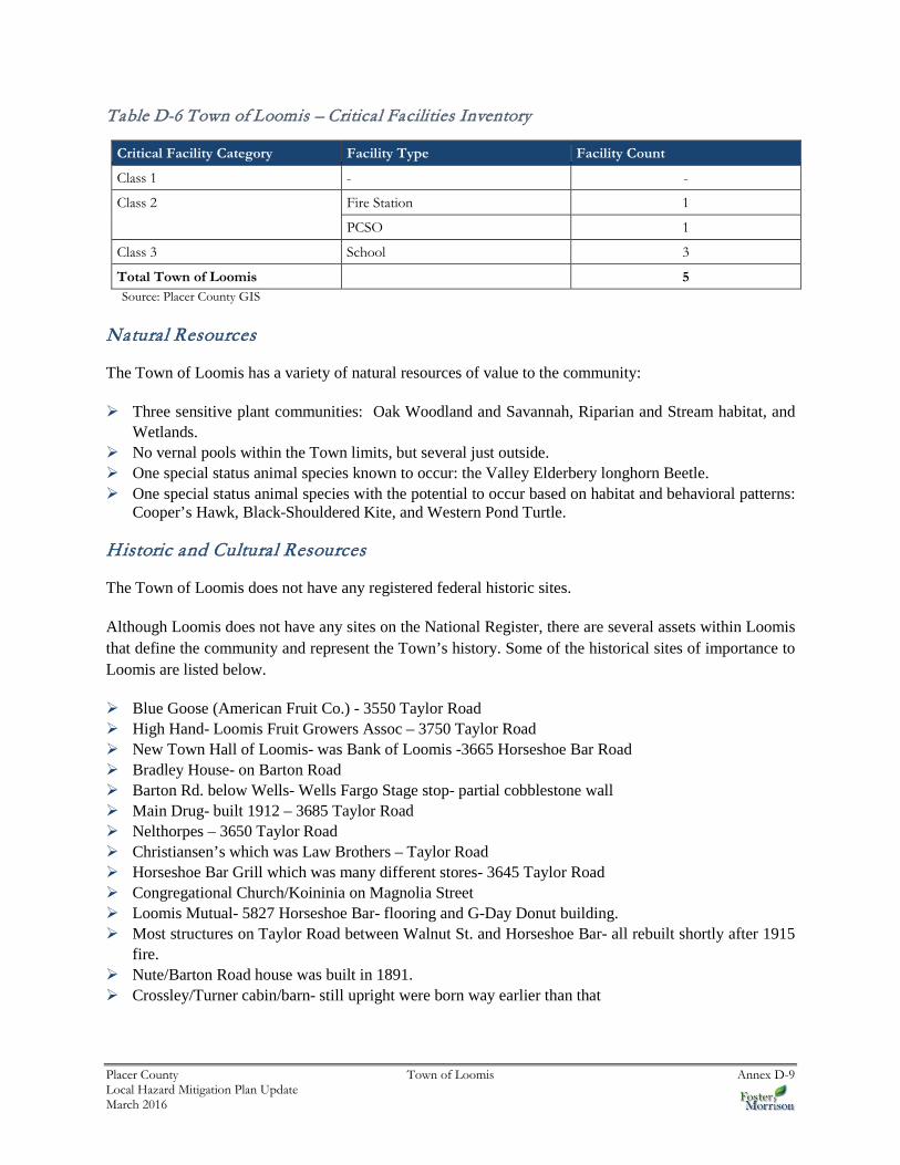
An inventory of critical facilities in the Town of Loomis from Placer County GIS is shown on Figure D-2 and detailed in Table D-6. Details of critical facility definition, type, name, address, and jurisdiction by hazard zone are listed in Appendix F.

Placer County Town of Loomis Annex D-8 Local Hazard Mitigation Plan Update March 2016
Figure D-2 Town of Loomis– Critical Facilities
Placer County Town of Loomis Annex D-9 Local Hazard Mitigation Plan Update March 2016
Table D-6 Town of Loomis – Critical Facilities Inventory
Critical Facility Category Facility Type Facility Count
Class 1 - -
Class 2 Fire Station 1
PCSO 1
Class 3 School 3
Total Town of Loomis 5 Source: Placer County GIS
Natural Resources
The Town of Loomis has a variety of natural resources of value to the community:
Three sensitive plant communities: Oak Woodland and Savannah, Riparian and Stream habitat, and Wetlands.
No vernal pools within the Town limits, but several just outside. One special status animal species known to occur: the Valley Elderbery longhorn Beetle. One special status animal species with the potential to occur based on habitat and behavioral patterns:
Cooper’s Hawk, Black-Shouldered Kite, and Western Pond Turtle.
Historic and Cultural Resources
The Town of Loomis does not have any registered federal historic sites.
Although Loomis does not have any sites on the National Register, there are several assets within Loomis that define the community and represent the Town’s history. Some of the historical sites of importance to Loomis are listed below.
Blue Goose (American Fruit Co.) - 3550 Taylor Road High Hand- Loomis Fruit Growers Assoc – 3750 Taylor Road New Town Hall of Loomis- was Bank of Loomis -3665 Horseshoe Bar Road Bradley House- on Barton Road Barton Rd. below Wells- Wells Fargo Stage stop- partial cobblestone wall Main Drug- built 1912 – 3685 Taylor Road Nelthorpes – 3650 Taylor Road Christiansen’s which was Law Brothers – Taylor Road Horseshoe Bar Grill which was many different stores- 3645 Taylor Road Congregational Church/Koininia on Magnolia Street Loomis Mutual- 5827 Horseshoe Bar- flooring and G-Day Donut building. Most structures on Taylor Road between Walnut St. and Horseshoe Bar- all rebuilt shortly after 1915
fire. Nute/Barton Road house was built in 1891. Crossley/Turner cabin/barn- still upright were born way earlier than that
Placer County Town of Loomis Annex D-10 Local Hazard Mitigation Plan Update March 2016
Growth and Development Trends
Since 1990, Loomis’ population has increased by nearly 13 percent from 5,705 people to 6,427, based on 2000 Census data. In 2010, the US Census Bureau estimated the population to be 6,430, which is virtually no increase since 2000. The California Department of Finance estimated the January 1, 2014 total population for the Town of Loomis was 6,608
Development since 2010 Plan
Development within the Town Limits has been limited over the past five years. The Town does not track building permits by hazard risk areas. However, Loomis does have building codes and construction standards in place that effectively mitigate against hazards. Thus, the development that has occurred has not significantly increased the Town’s vulnerability to hazards. With continued population growth anticipated, the City will need to continue to effectively manage future development in hazard-prone areas.
Future Development
The Sacramento Council on Governments (SACOG) modeled population projections for the City of Loomis and other areas of the region in 2012 for a Metropolitan Transportation Plan/Sustainable Communities Strategy report. This forecast uses a 2008 base year estimate with projections to 2020 and 2035 for population, housing units, households and employment. SACOG estimated the City population in 2020 and 2035 to be 6,443 and 8,463 respectively.
The Town of Loomis has identified sites in the Town that may be considered for future development. These areas are shown on Figure D-3.

Placer County Town of Loomis Annex D-11 Local Hazard Mitigation Plan Update March 2016
Figure D-3 Town of Loomis Future Development Areas
Source: Loomis Planning Commission
D.5.2. Estimating Potential Losses
This section provides the vulnerability assessment, including any quantifiable loss estimates, for those hazards identified above in Table D-4 as high or medium significance hazards. Impacts of past events and vulnerability of the Town to specific hazards are further discussed below (see Section 4.1 Hazard Identification for more detailed information about these hazards and their impacts on the Placer County

Placer County Town of Loomis Annex D-12 Local Hazard Mitigation Plan Update March 2016
planning area). Methodologies for calculating loss estimates are the same as those described in Section 4.3 of the base plan. In general, the most vulnerable structures are those located within the floodplain, in the wildland urban interface, other priority hazard areas, unreinforced masonry buildings, and buildings built prior to the introduction of modern building codes.
An estimate of the vulnerability of the Town to each identified hazard, in addition to the estimate of risk of future occurrence, is provided in each of the hazard-specific sections that follow. Vulnerability is measured in general, qualitative terms and is a summary of the potential impact based on past occurrences, spatial extent, and damage and casualty potential. It is categorized into the following classifications:
Extremely Low—The occurrence and potential cost of damage to life and property is very minimal to nonexistent.
Low—Minimal potential impact. The occurrence and potential cost of damage to life and property is minimal.
Medium—Moderate potential impact. This ranking carries a moderate threat level to the general population and/or built environment. Here the potential damage is more isolated and less costly than a more widespread disaster.
High—Widespread potential impact. This ranking carries a high threat to the general population and/or built environment. The potential for damage is widespread. Hazards in this category may have occurred in the past.
Extremely High—Very widespread with catastrophic impact.
Earthquake
Likelihood of Future Occurrence–Occasional Vulnerability–High
The most significant effect of an earthquake would likely be to the transportation system in the Town. Local bridges may be susceptible earthquakes. The railroad and freeway may also be effected by earthquakes. Many of the buildings in Loomis are only one and two stories.
Future Development
All future development in the Town is at risk to future earthquake. The City enforces building code, which mandates construction techniques that minimize seismic hazards. Future development in the City is subject to these building codes.
Flood: 100/500 year
Likelihood of Future Occurrence–Occasional Vulnerability–Medium
Loomis is traversed by several stream systems and is at risk to both the 100-year flood as well as to localized stormwater flooding. The Safety Element of Loomis’ General Plan notes that flooding has been a minor hazard because of the Town’s relatively elevated location compared to downstream localities. However, the 1998 Flood Insurance Rate Map does identify portions of Loomis that could be inundated in the event

Placer County Town of Loomis Annex D-13 Local Hazard Mitigation Plan Update March 2016
of 100- and 500-year floods from several creeks that flow through the Town (Antelope Creek, Secret Ravine, and Sucker Creek and their tributaries).
Local drainage problems exist because of inadequately-sized culverts and bridges that impede high water flows, including culverts under Interstate 80; the Horseshoe Bar Road crossing over Secret Ravine; the railroad and Taylor Road crossing of Sucker Ravine; and crossings of Antelope Creek and its tributaries. In the 1995 floods, local flooding did cause damage to the floors of a few buildings. Most recently, the 2005 New Year’s Eve flooding created significant problems in various areas of the Town.
A small portion of the City is located inside of the 100- and 500-year flood zone as defined by the Federal Emergency Management Agency (FEMA). This is seen in Figure D-4.

Placer County Town of Loomis Annex D-14 Local Hazard Mitigation Plan Update March 2016
Figure D-4 Town of Loomis – FEMA DFIRM Flood Zones

Placer County Town of Loomis Annex D-15 Local Hazard Mitigation Plan Update March 2016
Values at Risk
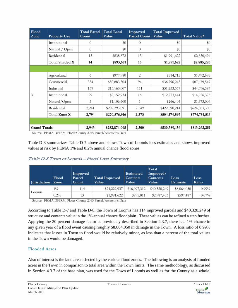
GIS was used to determine the possible impacts of flooding within the Town of Loomis. The methodology described in Section 4.3.7 of the base plan was followed in determining structures and values at risk to the 1% (100-year) and 0.2% (500-year) annual chance flood event. Table D-7 shows the property use, improved parcel count, improved values, estimated contents, total values and estimated loss of parcels that fall in a floodplain in the City.
Table D-7 Town of Loomis – Count and Improved Value by Property Use Detailed Flood Zone
Flood Zone Property Use
Total Parcel Count
Total Land Value
Improved Parcel Count
Total Improved Value Total Value*
A
Agricultural 0 $0 0 $0 $0
Commercial 1 $2,265,000 1 $4,850,000 $7,115,000
Industrial 0 $0 0 $0 $0
Institutional 0 $0 0 $0 $0
Natural/Open 0 $0 0 $0 $0
Residential 0 $0 0 $0 $0
Total Zone A 1 $2,265,000 1 $4,850,000 $7,115,000
AE
Agricultural 0 $0 0 $0 $0
Commercial 20 $1,434,051 2 $3,121,681 $4,555,732
Industrial 1 $0 0 $0 $0
Institutional 1 $0 0 $0 $0
Natural / Open 1 $0 0 $0 $0
Residential 111 $7,704,457 111 $16,251,256 $23,955,713
Total Zone AE 134 $9,138,508 113 $19,372,937 $28,511,445
AO
Agricultural 0 $0 0 $0 $0
Commercial 0 $0 0 $0 $0
Industrial 0 $0 0 $0 $0
Institutional 0 $0 0 $0 $0
Natural / Open 0 $0 0 $0 $0
Residential 0 $0 0 $0 $0
Total Zone AO 0 $0 0 $0 $0
Shaded X
Agricultural 0 $0 0 $0 $0
Commercial 1 $54,799 0 $0 $54,799
Industrial 0 $0 0 $0 $0
Placer County Town of Loomis Annex D-16 Local Hazard Mitigation Plan Update March 2016
Flood Zone Property Use
Total Parcel Count
Total Land Value
Improved Parcel Count
Total Improved Value Total Value*
Institutional 0 $0 0 $0 $0
Natural / Open 0 $0 0 $0 $0
Residential 13 $838,872 13 $1,991,622 $2,830,494
Total Shaded X 14 $893,671 13 $1,991,622 $2,885,293
X
Agricultural 6 $977,980 2 $514,715 $1,492,695
Commercial 354 $50,883,304 94 $36,796,243 $87,679,547
Industrial 159 $13,163,007 111 $31,233,577 $44,396,584
Institutional 29 $2,152,934 16 $12,773,444 $14,926,378
Natural/Open 5 $1,106,600 1 $266,404 $1,373,004
Residential 2,241 $202,293,091 2,149 $422,590,214 $624,883,305
Total Zone X 2,794 $270,576,916 2,373 $504,174,597 $774,751,513
Grand Totals 2,943 $282,874,095 2,500 $530,389,156 $813,263,251 Source: FEMA DFIRM, Placer County 2015 Parcel/Assessor’s Data
Table D-8 summarizes Table D-7 above and shows Town of Loomis loss estimates and shows improved values at risk by FEMA 1% and 0.2% annual chance flood zones.
Table D-8 Town of Loomis – Flood Loss Summary
Jurisdiction Flood Zone
Improved Parcel Count
Total Improved Value
Estimated Contents Value
Total Improved/ Contents Value
Loss Estimate
Loss Ratio
Loomis 1% 114 $24,222,937 $16,097,312 $40,320,249 $8,064,050 0.99%
0.2% 13 $1,991,622 $995,811 $2,987,433 $597,487 0.07% Source: FEMA DFIRM, Placer County 2015 Parcel/Assessor’s Data
According to Table D-7 and Table D-8, the Town of Loomis has 114 improved parcels and $40,320,249 of structure and contents value in the 1% annual chance floodplain. These values can be refined a step further. Applying the 20 percent damage factor as previously described in Section 4.3.7, there is a 1% chance in any given year of a flood event causing roughly $8,064,050 in damage in the Town. A loss ratio of 0.99% indicates that losses in Town to flood would be relatively minor, as less than a percent of the total values in the Town would be damaged.
Flooded Acres
Also of interest is the land area affected by the various flood zones. The following is an analysis of flooded acres in the Town in comparison to total area within the Town limits. The same methodology, as discussed in Section 4.3.7 of the base plan, was used for the Town of Loomis as well as for the County as a whole.

Placer County Town of Loomis Annex D-17 Local Hazard Mitigation Plan Update March 2016
Table D-9 represents a detailed and summary analysis of total acres for each FEMA DFIRM flood zone in the City.
Table D-9 Town of Loomis – Flooded Acres
Flood Zone Property Use Total Flooded Acres Improved Flooded Acres
% of Improved Flooded Acres
A
Agricultural 0 0 0.0%
Commercial 5.28 5.28 100.0%
Industrial 0 0 0.0%
Institutional 0 0 0.0%
Natural/Open 0 0 0.0%
Residential 0 0 0.0%
AE
Agricultural 0 0 0.0%
Commercial 34.13 3.27 9.6%
Industrial 0.37 0 0.0%
Institutional 0.20 0 0.0%
Natural/Open 4.04 0 0.0%
Residential 122.71 122.71 100.0%
AO
Agricultural 0 0 0.0%
Commercial 0 0 0.0%
Industrial 0 0 0.0%
Institutional 0 0 0.0%
Natural/Open 0 0 0.0%
Residential 0 0 0.0%
Total 1% 166.73 131.25 78.7%
Shaded X
Agricultural 0 0 0.0%
Commercial 0.62 0 0.0%
Industrial 0 0 0.0%
Institutional 0 0 0.0%
Natural/Open 0 0 0.0%
Residential 15.64 15.64 100.0%
Total 0.2% 16.26 15.64 96.2% Source: FEMA DFIRM, Placer County 2015 Parcel/Assessor’s Data
Population at Risk
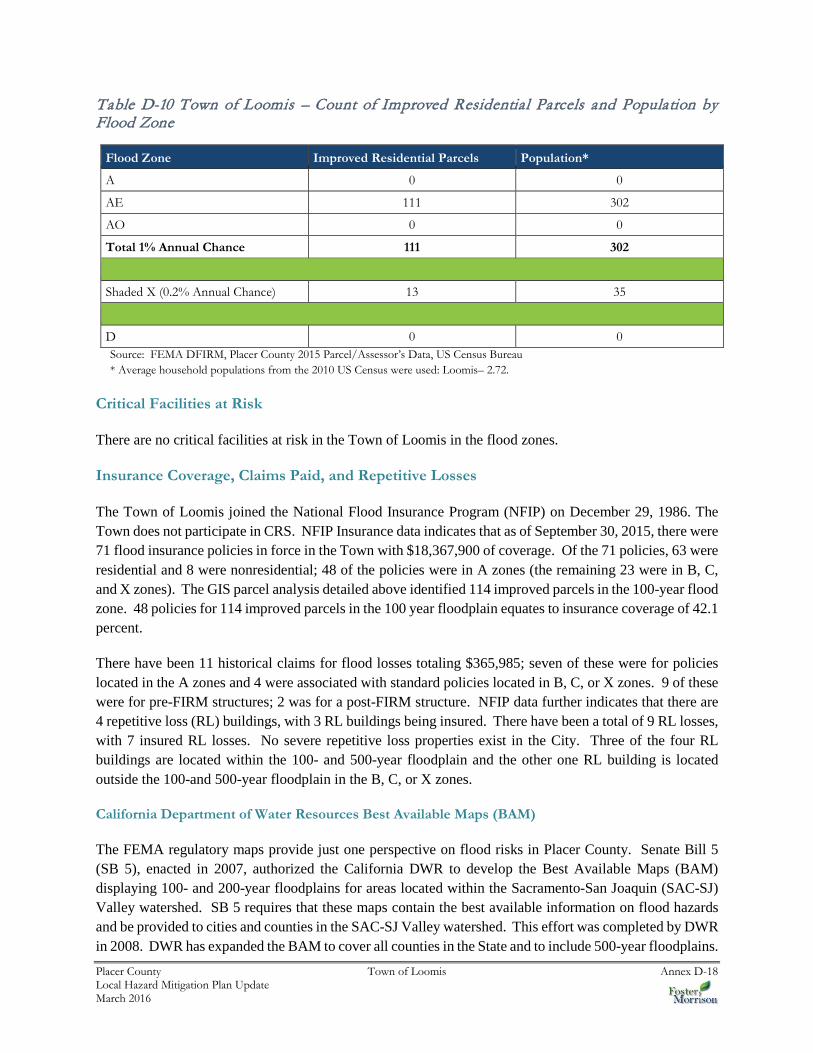
The DFIRM flood zones were overlayed on the parcel layer. Those residential parcel centroids that intersect the severity zones were counted and multiplied by the 2010 Census Bureau average household factors for Loomis. According to this analysis, there is a total population of 337 residents of the City at risk to flooding, 302 in the 1% and 35 in the 0.2% annual chance floodplains. This is shown in Table D-10.
Placer County Town of Loomis Annex D-18 Local Hazard Mitigation Plan Update March 2016
Table D-10 Town of Loomis – Count of Improved Residential Parcels and Population by Flood Zone
Flood Zone Improved Residential Parcels Population*
A 0 0
AE 111 302
AO 0 0
Total 1% Annual Chance 111 302
Shaded X (0.2% Annual Chance) 13 35
D 0 0 Source: FEMA DFIRM, Placer County 2015 Parcel/Assessor’s Data, US Census Bureau * Average household populations from the 2010 US Census were used: Loomis– 2.72.
Critical Facilities at Risk
There are no critical facilities at risk in the Town of Loomis in the flood zones.
Insurance Coverage, Claims Paid, and Repetitive Losses
The Town of Loomis joined the National Flood Insurance Program (NFIP) on December 29, 1986. The Town does not participate in CRS. NFIP Insurance data indicates that as of September 30, 2015, there were 71 flood insurance policies in force in the Town with $18,367,900 of coverage. Of the 71 policies, 63 were residential and 8 were nonresidential; 48 of the policies were in A zones (the remaining 23 were in B, C, and X zones). The GIS parcel analysis detailed above identified 114 improved parcels in the 100-year flood zone. 48 policies for 114 improved parcels in the 100 year floodplain equates to insurance coverage of 42.1 percent.
There have been 11 historical claims for flood losses totaling $365,985; seven of these were for policies located in the A zones and 4 were associated with standard policies located in B, C, or X zones. 9 of these were for pre-FIRM structures; 2 was for a post-FIRM structure. NFIP data further indicates that there are 4 repetitive loss (RL) buildings, with 3 RL buildings being insured. There have been a total of 9 RL losses, with 7 insured RL losses. No severe repetitive loss properties exist in the City. Three of the four RL buildings are located within the 100- and 500-year floodplain and the other one RL building is located outside the 100-and 500-year floodplain in the B, C, or X zones.
California Department of Water Resources Best Available Maps (BAM)
The FEMA regulatory maps provide just one perspective on flood risks in Placer County. Senate Bill 5 (SB 5), enacted in 2007, authorized the California DWR to develop the Best Available Maps (BAM) displaying 100- and 200-year floodplains for areas located within the Sacramento-San Joaquin (SAC-SJ) Valley watershed. SB 5 requires that these maps contain the best available information on flood hazards and be provided to cities and counties in the SAC-SJ Valley watershed. This effort was completed by DWR in 2008. DWR has expanded the BAM to cover all counties in the State and to include 500-year floodplains.
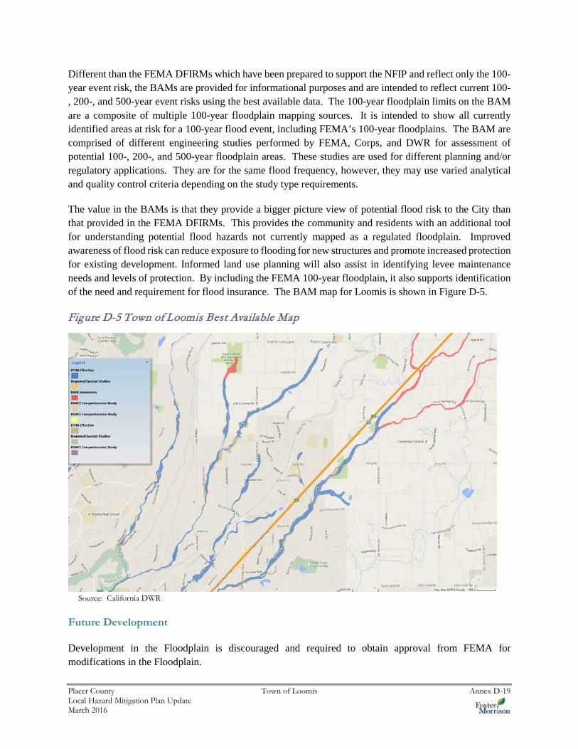
Placer County Town of Loomis Annex D-19 Local Hazard Mitigation Plan Update March 2016
Different than the FEMA DFIRMs which have been prepared to support the NFIP and reflect only the 100-year event risk, the BAMs are provided for informational purposes and are intended to reflect current 100-, 200-, and 500-year event risks using the best available data. The 100-year floodplain limits on the BAM are a composite of multiple 100-year floodplain mapping sources. It is intended to show all currently identified areas at risk for a 100-year flood event, including FEMA’s 100-year floodplains. The BAM are comprised of different engineering studies performed by FEMA, Corps, and DWR for assessment of potential 100-, 200-, and 500-year floodplain areas. These studies are used for different planning and/or regulatory applications. They are for the same flood frequency, however, they may use varied analytical and quality control criteria depending on the study type requirements.
The value in the BAMs is that they provide a bigger picture view of potential flood risk to the City than that provided in the FEMA DFIRMs. This provides the community and residents with an additional tool for understanding potential flood hazards not currently mapped as a regulated floodplain. Improved awareness of flood risk can reduce exposure to flooding for new structures and promote increased protection for existing development. Informed land use planning will also assist in identifying levee maintenance needs and levels of protection. By including the FEMA 100-year floodplain, it also supports identification of the need and requirement for flood insurance. The BAM map for Loomis is shown in Figure D-5.
Figure D-5 Town of Loomis Best Available Map
Source: California DWR
Future Development
Development in the Floodplain is discouraged and required to obtain approval from FEMA for modifications in the Floodplain.

Placer County Town of Loomis Annex D-20 Local Hazard Mitigation Plan Update March 2016
Severe Weather: Heavy Rains and Storms (Thunderstorms/Hail, Lightning/Wind/Tornadoes)
Likelihood of Future Occurrence–Occasional Vulnerability–Medium
According to historical hazard data, severe weather is an annual occurrence in the Town of Loomis. Damage and disaster declarations related to severe weather have occurred and can be expected to occur in the future. Heavy rain and thunderstorms are the most frequent type of severe weather occurrence in the area. Wind and lightning often accompany these storms and have caused damage in the past. Problems associated with the primary effects of severe weather include flooding, pavement deterioration, washouts, high water crossings, landslide/mudslides, debris flows, and downed trees.
Future Development
The City enforces building codes and other ordinances, which regulate construction techniques that minimize damage from heavy storms and rain. Future development in the City is subject to these building codes. New critical facilities such as communications towers should be built to withstand hail damage, lightning, and heavy rains.
Wildfire
Likelihood of Future Occurrence–Likely Vulnerability–High
According to the Safety Element of the General Plan, two types of fires are of concern to the Town of Loomis: wildland (including wildland urban interface) fires and structural fires. The topography, climate, and vegetation of Loomis are conducive to the spread of wildland fires. It contains extensive grasslands and oak woodlands in rolling terrain. The area is subject to hot, dry summers, with frequent wind gusts. However, prolonged summer heat spells often induce the delta breeze, a moist, cooling wind that temporarily reduces the high fire hazard condition common during the summer months.
Although small grass fires are common in the planning area, they have historically been limited in size by prompt emergency response. In 2002 the town was impacted by the Sierra Fire which burned 900 acres, including six structures. More than 100 homes were evacuated and over 1,000 homes were threatened in both Loomis and Granite Bay. The structural fire hazard, caused largely by human activities, is greatest in areas containing older buildings that do not meet current building codes.
Following the methodology described in Section 4.3.2 Vulnerability of Placer County to Specific Hazards, a wildfire map for the Town of Loomis was created (see Figure D-6). Wildfire threat within the Town is moderate.

Placer County Town of Loomis Annex D-21 Local Hazard Mitigation Plan Update March 2016
Figure D-6 Town of Loomis’s Fire Severity Zones

Placer County Town of Loomis Annex D-22 Local Hazard Mitigation Plan Update March 2016
Values at Risk
Analysis results for Loomis are shown in Table D-12, which summarizes total parcel counts, improved parcel counts and their structure values by occupancy type as well as the percentage of parcels affected by fire.
Table D-11 Town of Loomis – Count and Value of Parcels by Property Use and Fire Severity Zone
Fire Severity Zone
Property Use
Total Parcel Count
Total Land Value
Improved Parcel Count
Improved Value
Total Value*
% of Affected Parcels to Total
Very High
Agricultural 0 $0 0 $0 $0 0.0%
Commercial 0 $0 0 $0 $0 0.0%
Industrial 0 $0 0 $0 $0 0.0%
Institutional 0 $0 0 $0 $0 0.0%
Natural/Open Space
0 $0 0 $0 $0 0.0%
Residential 0 $0 0 $0 $0 0.0%
Total 0 $0 0 $0 $0 0.0%
High
Agricultural 0 $0 0 $0 $0 0.0%
Commercial 5 $186,422 0 $0 $186,422 0.0%
Industrial 0 $0 0 $0 $0 0.0%
Institutional 0 $0 0 $0 $0 0.0%
Natural/Open Space
1 $0 0 $0 $0 0.0%
Residential 32 $2,156,929 27 $5,827,719 $7,984,648 1.2%
Total 38 $2,343,351 27 $5,827,719 $8,171,070 1.1%
Moderate
Agricultural 6 $977,980 2 $514,715 $1,492,695 100.0%
Commercial 219 $35,378,507 33 $18,150,436 $53,528,943 34.0%
Industrial 22 $1,537,020 5 $1,074,614 $2,611,634 4.5%
Institutional 13 $1,095,687 10 $9,400,299 $10,495,986 62.5%
Natural/Open Space
3 $1,106,600 1 $266,404 $1,373,004 100.0%
Residential 1,014 $118,690,025 978 $249,218,906 $367,908,931 43.0%
Total 1,277 $158,785,819 1,029 $278,625,374 $437,411,193 41.2%
Urban Unzoned
Agricultural 0 $0 0 $0 $0 0.0%
Commercial 152 $19,072,225 64 $26,617,488 $45,689,713 66.0%

Placer County Town of Loomis Annex D-23 Local Hazard Mitigation Plan Update March 2016
Fire Severity Zone
Property Use
Total Parcel Count
Total Land Value
Improved Parcel Count
Improved Value
Total Value*
% of Affected Parcels to Total
Industrial 138 $11,625,987 106 $30,158,963 $41,784,950 95.5%
Institutional 17 $1,057,247 6 $3,373,145 $4,430,392 37.5%
Natural/Open Space
2 $0 0 $0 $0 0.0%
Residential 1,312 $89,495,641 1,262 $185,141,914 $274,637,555 55.5%
Total 1,621 $121,251,100 1,438 $245,291,510 $366,542,610 57.5%
Non-Wildland/Non-Urban
Agricultural 0 $0 0 $0 $0 0.0%
Commercial 0 $0 0 $0 $0 0.0%
Industrial 0 $0 0 $0 $0 0.0%
Institutional 0 $0 0 $0 $0 0.0%
Natural/Open Space
0 $0 0 $0 $0 0.0%
Residential 7 $493,825 6 $644,553 $1,138,378 0.3%
Total 7 $493,825 6 $644,553 $1,138,378 0.2%
Grand Total 2,943 $282,874,095 2,500 $530,389,156 $813,263,251 100.0% Source: Placer County 2015 Parcel/Assessor’s Data, CAL FIRE *Land and structure values
Population at Risk
The Fire Severity Zone dataset was overlayed on the parcel layer. Those residential parcel centroids that intersect the severity zones were counted and multiplied by the 2010 Census Bureau average household factors for each jurisdiction and unincorporated area. Results were tabulated by jurisdiction. According to this analysis, there is a total population of 2,733 residents of Loomis at risk to moderate or higher wildfire risk. This is shown in Table D-13.

Placer County Town of Loomis Annex D-24 Local Hazard Mitigation Plan Update March 2016
Table D-12 Town of Loomis – Count of Improved Residential Parcels and Population by Fire Severity Zone
Fire Severity Zone Improved Residential Parcels Population*
Very High 0 0
High 27 73
Moderate 978 2,660
Urban Unzoned 1,262 3,433
Non-Wildland/Urban 6 16
None 0 0
Total 2,273 6,183 Source: Placer County 2015 Parcel/Assessor’s Data, CAL FIRE * Average household populations for Loomis (2.72) from the 2010 US Census were used
Critical Facilities at Risk
Wildfire analysis was performed on the critical facility inventory in Placer County and all jurisdictions. GIS was used to determine whether the facility locations intersect a fire severity zone provided by CAL FIRE, and if so, which zone it intersects. There is one facility in the moderate or higher fire severity zone in the City. These are shown in Figure D-7 and detailed in Table D-14. Details of critical facility definition, type, name and address and jurisdiction by fire zone are listed in Appendix F.

Placer County Town of Loomis Annex D-25 Local Hazard Mitigation Plan Update March 2016
Figure D-7 Town of Loomis – Critical Facilities in the Fire Severity Zones

Placer County Town of Loomis Annex D-26 Local Hazard Mitigation Plan Update March 2016
Table D-13 Town of Loomis– Critical Facilities in the Fire Severity Zones
Fire Hazard Severity Zone Critical Facility Class Facility Type Facility Count
Very High Class 1 - -
Class 2 - -
Class 3 - -
Total Very High 0
High Class 1 - -
Class 2 - -
Class 3 - -
Total High 0
Moderate Class 1 - -
Class 2 PCSO 1
Class 3 - -
Total Moderate 1
Non-Wildland/Non-Urban Class 1 -
Class 2 -
Class 3 School 1
Total Non-Wildland/Non-Urban 0
Urban Unzoned Class 1
Class 2 Fire Station 1
Class 3 School 3
Total Urban Unzoned 4
Total 5 Source: CAL FIRE, Placer County GIS
Future Development
All new development in the WUI is subject to Fire Department approval that requires adequate fire breaks for structures.
Hazardous Materials Transport
Likelihood of Future Occurrence–Likely Vulnerability–High
The Union Pacific Railroad line passes through the Town of Loomis. Hazardous materials are regularly shipped via the rail line and, while unlikely, an incident involving a rail accident within the City could have devastating effects.
The City has little control over the types of materials that are shipped via the rail line. With regard to government activities, the content of shipments may be confidential for reasons of security and/or is
Placer County Town of Loomis Annex D-27 Local Hazard Mitigation Plan Update March 2016
generally unknown to the City. While the City has little influence over the types of material transported via the rail line, the potential for rail incidents can be reduced by ensuring that at-grade crossings within the City are operating in a safe and effective manner.
Interstate 80 passes through the City as well. This is a designated Cal Trans haz-mat routes.
Populations at Risk
To determine the populations at risk from a transportation-related hazardous materials release within identified transportation corridors, an analysis was performed using GIS. A one mile buffer was applied to both sides of Highways 20, 49, 65, 80, 89, 174, 193, and 267, as well as the BNSF and Union Pacific Railroads. The result is a two-mile buffer zone around each transportation corridor that is used for risk-analysis.
Analysis was done for jurisdictions found in Table D-15. This table shows total population that are within the proximity of this two-mile buffer of all the highway and railroad corridors. Using GIS, the buffered corridor was overlaid on the improved residential parcel data. Those parcel centroids that intersect the buffered corridor were counted and multiplied by the 2010 Census Bureau average household factors for the City. According to this analysis, there is a total population of 6,425 in the buffered corridors.
Table D-14 Town of Loomis – Populations at Risk in Haz-Mat Corridors
Jurisdiction Residential Parcels Population
Loomis 2,362 6,425 Source: Cal Trans, Placer County GIS, US Census Bureau * Average household populations from the 2010 US Census were used: Loomis– 2.72.
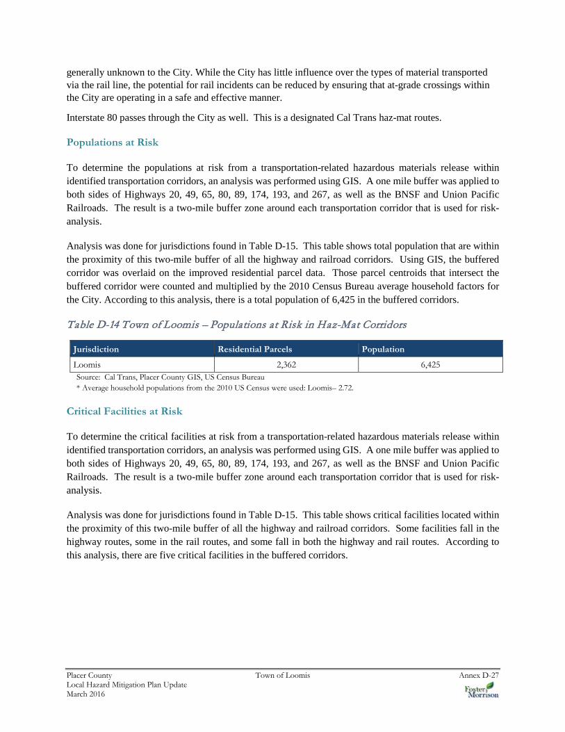
Critical Facilities at Risk
To determine the critical facilities at risk from a transportation-related hazardous materials release within identified transportation corridors, an analysis was performed using GIS. A one mile buffer was applied to both sides of Highways 20, 49, 65, 80, 89, 174, 193, and 267, as well as the BNSF and Union Pacific Railroads. The result is a two-mile buffer zone around each transportation corridor that is used for risk-analysis.
Analysis was done for jurisdictions found in Table D-15. This table shows critical facilities located within the proximity of this two-mile buffer of all the highway and railroad corridors. Some facilities fall in the highway routes, some in the rail routes, and some fall in both the highway and rail routes. According to this analysis, there are five critical facilities in the buffered corridors.
Placer County Town of Loomis Annex D-28 Local Hazard Mitigation Plan Update March 2016
Figure D-8 Town of Loomis – Critical Facilities at Risk in Haz-Mat Corridors

Placer County Town of Loomis Annex D-29 Local Hazard Mitigation Plan Update March 2016
Table D-15 Town of Loomis– Critical Facilities at Risk in Haz-Mat Corridors
Hazardous Materials Route
Critical Facility Class Facility Type Facility Count
Hazardous Materials Highway Route
Class 1 - -
Class 2 - -
Class 3 - -
Total Hazardous Materials Highway Route
0
Hazardous Materials Railroad Route
Class 1 - -
Class 2 - -
Class 3 School 1
Total Hazardous Materials Railroad Route
1
Combined Hazardous Materials Highway and Railroad Route
Class 1 - -
Class 2 Fire Station 1
PCSO 1
Class 3 School 2
Total Combined Routes 4
Total 5 Source: Cal Trans, Placer County GIS, US Census Bureau
Future Development
Development will continue to occur in hazmat affected areas. It is important that the City make residents who choose to live or develop in hazmat zones about the possibility of being affected by a hazmat spill.
D.6 Capability Assessment
Capabilities are the programs and policies currently in use to reduce hazard impacts or that could be used to implement hazard mitigation activities. This capabilities assessment is divided into four sections: regulatory mitigation capabilities; administrative and technical mitigation capabilities; fiscal mitigation capabilities; and mitigation education, outreach, and partnerships.
D.6.1. Regulatory Mitigation Capabilities
Table D-17 lists regulatory mitigation capabilities, including planning and land management tools, typically used by local jurisdictions to implement hazard mitigation activities and indicates those that are in place in the Town.

Placer County Town of Loomis Annex D-30 Local Hazard Mitigation Plan Update March 2016
Table D-16 Town of Loomis’s Regulatory Mitigation Capabilities
Plans Y/N Year
Does the plan/program address hazards? Does the plan identify projects to include in the mitigation strategy? Can the plan be used to implement mitigation actions?
Comprehensive/Master Plan Y
Capital Improvements Plan Y The Public Works Department looks for opportunities to improve/correct hazards that are within or adjacent to CIPs.
Economic Development Plan N The Town is working with Planning and the Chamber of Commerce to develop a plan
Local Emergency Operations Plan Y
Continuity of Operations Plan N
Transportation Plan Y
Stormwater Management Plan/Program Y
Engineering Studies for Streams Y
Community Wildfire Protection Plan Y
Other special plans (e.g., brownfields redevelopment, disaster recovery, coastal zone management, climate change adaptation)
N
Building Code, Permitting, and Inspections Y/N Are codes adequately enforced?
Building Code Y Version/Year:
Building Code Effectiveness Grading Schedule (BCEGS) Score
Y Score:
Fire department ISO rating: NA Rating: (Loomis does not operate its fire department)
Site plan review requirements
Land Use Planning and Ordinances Y/N
Is the ordinance an effective measure for reducing hazard impacts? Is the ordinance adequately administered and enforced?
Zoning ordinance Y
Subdivision ordinance Y
Floodplain ordinance Y
Natural hazard specific ordinance (stormwater, steep slope, wildfire)
Y
Flood insurance rate maps Y
Elevation Certificates Y
Acquisition of land for open space and public recreation uses
Y
Erosion or sediment control program Y
Other
How can these capabilities be expanded and improved to reduce risk?
Placer County Town of Loomis Annex D-31 Local Hazard Mitigation Plan Update March 2016
As indicated above, the Town has several programs, plans, policies, and codes and ordinances that guide hazard mitigation. Some of these are described in more detail below.
As indicated above, the Town has several programs, plans, policies, codes and ordinances in place and/or that they follow. The General Plan for the Town of Loomis is the most comprehensive. The following section provides an overview of the General Plan and identifies specific policies related to hazard mitigation that are included in the plan.
The Town of Loomis General Plan Program, 2001
The Town of Loomis General Plan Program serves as the blueprint for future growth and development and provides comprehensive planning for the future. It encompasses what the Town is now, and what it intends to be, and provides the overall framework of how to achieve this future condition (see the discussion in Section 4.3.1 Growth and Development Trends).
The general plan includes a Safety Element that focuses on safety issues to be considered in planning for the present and future development of the Loomis Planning Area. Identified hazards include fire, geologic/seismic, flooding, and hazardous materials. Mitigation-related issues, goals, policies, and actions are presented below.
Issues
Issue 1: The rural nature of the community and presence of large open space parcels increases the Town’s risk of wildland and fire hazards at the urban edge.
Issue 2: A number of properties along local creeks have been flooded during winter storms, despite flood preventative measures.
Goals Goal 1: To reduce the risks associated with wildland and urban edge fires in the Town’s rural areas. Goal 2: To reduce the risks associated with wildland and urban edge fires in the Town’s rural areas. Goal 3: To reduce the potential for and damage resulting from storm flooding hazards within the community. Goal 4: To reduce the risks associated with potential seismic activity, including groundshaking, liquefaction,
and landslides.
Policies
Policy 1: Loomis shall enforce building codes and other Town ordinances having an effect upon fire hazards and fire protection. The Town shall maintain adequate street widths and turning radii to accommodate fire protection equipment. New development shall ensure adequate water pressure and volume for firefighting.
Policy 2: Engineering analysis of new development proposals shall be required in areas with possible soil instability, flooding, earthquake faults, or other hazards, and prohibit development in high danger areas.

Placer County Town of Loomis Annex D-32 Local Hazard Mitigation Plan Update March 2016
Policies
Policy 3: Loomis shall comply with Placer County's Emergency Response Plan, as well as revise the Town Emergency Plan to address Town-specific issues.
Policy 4: No new structures or additions to existing structures shall be permitted in areas identified by the federal Flood Insurance Rate Maps (FIRMs) or the Town Engineer as being subject to inundation in a 100-year or more frequent flood event. Exceptions may be granted for public facilities and utilities. New development shall also be prohibited in the future 100-year flood zone, based on buildout conditions as determined by FEMA and FIRM maps. Development will be required to adhere to Placer County Flood Control District policies and the Dry Creek Watershed Control Plan.
Policy 5: New development near stream channels shall be designed so that reduced stream capacity, stream bank erosion, or adverse impacts on habitat values are avoided.
Policy 6: Further channelization and/or banking of creeks or streams within the planning area shall be discouraged, unless no other alternative is available to minimize flood risk. Setbacks from flood sources shall be the preferred method of avoiding impacts.
Policy 7: Site-specific recommendations of the Town’s Drainage Master Plan, upon completion, shall be applied to individual development projects as appropriate.
Policy 8: Loomis shall cooperate with Federal, State, and local authorities to ensure that loss due to seismic activity and other natural and man-made disasters is minimized.
Policy 9: Loomis shall encourage compliance with State requirements for unreinforced masonry buildings and seismic safety.
Policy 10: Loomis shall continue to train and equip Town personnel to cope with emergency disaster situations, including hazardous material incidents.
Policy 11: A Street Address Ordinance shall be adopted to assist effective emergency response by requiring adequate street address identification.
Policy 12: Application materials for residential subdivisions proposed within or near oak woodlands shall include Wildland fire protection plans showing how vegetation clearance will be maintained around structures while preserving oak trees.
D.6.2. Administrative/Technical Mitigation Capabilities
Table D-18 identifies the personnel responsible for activities related to mitigation and loss prevention in the Town.
Table D-17 Town of Loomis’s Administrative and Technical Mitigation Capabilities
Administration Y/N Describe capability Is coordination effective?
Planning Commission Y
Mitigation Planning Committee N
Maintenance programs to reduce risk (e.g., tree trimming, clearing drainage systems)
Y
Mutual aid agreements Y
Other

Placer County Town of Loomis Annex D-33 Local Hazard Mitigation Plan Update March 2016
Staff Y/N
FT/PT
Is staffing adequate to enforce regulations? Is staff trained on hazards and mitigation? Is coordination between agencies and staff effective?
Chief Building Official Y Consultant
Floodplain Administrator Y Certified Floodplain Manager
Emergency Manager Y Town Manager
Community Planner Y Consultant
Civil Engineer Y Licensed Professional Engineer
GIS Coordinator N
Other
Technical Y/N
Describe capability Has capability been used to assess/mitigate risk in the past?
Warning systems/services (Reverse 911, outdoor warning signals)
N The Town relies on the County and Fire District that do have these services
Hazard data and information Y
Grant writing N
Hazus analysis N
Other
How can these capabilities be expanded and improved to reduce risk?
D.6.3. Fiscal Mitigation Capabilities
Table D-19 identifies financial tools or resources that the Town could potentially use to help fund mitigation activities.
Table D-18 Town of Loomis’s Fiscal Mitigation Capabilities
Funding Resource
Access/ Eligibility
(Y/N)
Has the funding resource been used in past and for what type of activities? Could the resource be used to fund future mitigation actions?
Capital improvements project funding Y
Authority to levy taxes for specific purposes Y
Fees for water, sewer, gas, or electric services N
Impact fees for new development Y
Storm water utility fee Y
Incur debt through general obligation bonds and/or special tax bonds
Y
Incur debt through private activities Y
Community Development Block Grant Y

Placer County Town of Loomis Annex D-34 Local Hazard Mitigation Plan Update March 2016
Funding Resource
Access/ Eligibility
(Y/N)
Has the funding resource been used in past and for what type of activities? Could the resource be used to fund future mitigation actions?
Other federal funding programs Y
State funding programs Y
Other
How can these capabilities be expanded and improved to reduce risk?
D.6.4. Mitigation Education, Outreach, and Partnerships
Table D-20 identifies education and outreach programs and methods already in place that could be/or are used to implement mitigation activities and communicate hazard-related information. More information can be found below the table.
Table D-19 Town of Loomis’s Mitigation Education, Outreach, and Partnerships
Program/Organization Yes/No
Describe program/organization and how relates to disaster resilience and mitigation. Could the program/organization help implement future mitigation activities?
Local citizen groups or non-profit organizations focused on environmental protection, emergency preparedness, access and functional needs populations, etc.
N
Ongoing public education or information program (e.g., responsible water use, fire safety, household preparedness, environmental education)
Y
Natural disaster or safety related school programs Y
StormReady certification N
Firewise Communities certification Y
Public-private partnership initiatives addressing disaster-related issues
N
Other
How can these capabilities be expanded and improved to reduce risk?
Town of Loomis Code Enforcement works with the Loomis Fire Department to notify and remind residents and businesses within Loomis to provide the required fire protection buffer zone. The Town and Fire Department mail out letters to all that are in violation. Within this letter sections 7.04.010 – 7.04.190 of the Loomis Code are referenced.

Placer County Town of Loomis Annex D-35 Local Hazard Mitigation Plan Update March 2016
D.6.5. Other Mitigation Efforts
The Town of Loomis has many other ongoing mitigation efforts that include the following:
In 2000-2001 the Town replaced all old street signs with new larger and more reflective signs. The Town’s construction standard was also changed so that all new developments within town are built to this standard. By increasing the size of lettering and requiring them to be made with a high intensity back ground will help emergency responders.
The Town’s Maintenance Department evaluates and then focuses efforts on the creeks and channels that have the highest probability to cause flooding.
D.7 Mitigation Strategy
D.7.1. Mitigation Goals and Objectives
The Town adopts the hazard mitigation goals and objectives developed by the HMPC and described in Chapter 5 Mitigation Strategy.
D.7.2. NFIP Mitigation Strategy
The Town of Loomis joined the National Flood Insurance Program (NFIP) on December 29, 1986. As a participant of the NFIP, the Town of Loomis has administered floodplain management regulations that meet the minimum requirements of the NFIP. The management program objective is to protect people and property within the Town. The Town of Loomis will continue to comply with the requirements of the NFIP in the future.
In addition, the Town of Loomis actively participates with the County of Placer to address local NFIP issues through a regional approach. Many of the program activities are the same for the Town of Loomis as for Placer County since participation at the County level includes all local jurisdictions. An elected official of the Town of Loomis is a designated representative on the Placer County Flood Control District Board.
The Town’s regulatory activities apply to existing and new development areas of the Town; implementing flood protection measures for existing structures and new development, and maintaining drainage systems. The goal of the program is to enhance public safety, and reduce impacts and losses while protecting the environment. The Town has a Flood Damage Prevention Ordinance that regulates construction in the floodplain. The Town intends to continue to implement the ordinance and participate at the regional level with Placer County implementing appropriate measures to mitigate exposure and damages within designated flood prone areas.
The National Flood Insurance Program’s (NFIP) Community Rating System (CRS) is a voluntary incentive program that recognizes and encourages community floodplain management activities that exceed the minimum NFIP requirements. As a result, flood insurance premium rates are discounted to reflect the reduced flood risk resulting from the community actions meeting the three goals of the CRS which are to reduce flood losses, facilitate accurate insurance rating, and promote the awareness of flood insurance. The Town of Loomis is not a current participant in the CRS program.

Placer County Town of Loomis Annex D-36 Local Hazard Mitigation Plan Update March 2016
D.7.3. Mitigation Actions
The planning team for the Town identified and prioritized the following mitigation action based on the risk assessment. Background information and information on how each action will be implemented and administered, such as ideas for implementation, responsible office, partners, potential funding, estimated cost, and schedule are included.
Action 1. Integrate Local Hazard Mitigation Plan into Safety Element of General Plan
Hazards Addressed: All hazards
Issue/Background: Local jurisdictional reimbursement for mitigation projects and cost recovery after a disaster is guided by Government Code Section 8685.9 (AB 2140). Specifically, this section requires that each jurisdiction adopt a local hazard mitigation plan (LHMP) in accordance with the federal Disaster Mitigation Act of 2000 as part of the Safety Element of its General Plan. Adoption of the LHMP into the Safety Element of the General Plan may be by reference or incorporation.
Other Alternatives: No action
Existing Planning Mechanisms through which Action will be Implemented: Safety Element of General Plan
Responsible Office: Town of Loomis Planning Department
Priority (H, M, L): High
Cost Estimate: Jurisdictional board/staff time
Potential Funding: Local budgets
Benefits (avoided Losses): Incorporation of an adopted LHMP into the Safety Element of the General Plan will help jurisdictions maximize the cost recovery potential following a disaster.
Schedule: As soon as possible
Action 1. Local Bridges Evaluation Program
Hazard Addressed: Multi-hazard
Issue/Background Statement: Working with the local Fire Districts evaluate all the bridges in the Town limits and ensure they meet minimum requirements.
Other Alternatives:
Existing Planning Mechanisms through which Action Will be Implemented: Working with the local Fire Districts set minimum criteria, evaluate local bridges, seek funding to improve bridges to minimum standards.
Placer County Town of Loomis Annex D-37 Local Hazard Mitigation Plan Update March 2016
Responsible Office: Town of Looms and Loomis Fire Protection District
Priority (H, M, L): M
Cost Estimate: To be determined.
Benefits (Losses Avoided): Reduced loss of life.
Potential Funding: To be determined
Schedule: To be determined
Action 2. Address Signage for Property Addresses
Hazard Addressed: Multi-hazard
Issue/Background: Finding addresses on rural roads with no street lights.
Other Alternatives:
Existing Planning Mechanism(s) through which Action Will Be Implemented: Get engineers estimate and propose to Town Council.
Responsible Office: Town of Loomis
Priority (High, Medium, Low): Low
Cost Estimate: $30,000
Benefits (Losses Avoided): Reduced loss of life.
Potential Funding: To be determined.
Schedule: To be determined.
Action 3. Delmar Avenue Headwall Reconstruction
Hazard Addressed: Flooding
Issue/Background: Headwall has cracked vertically.
Other Alternatives:
Existing Planning Mechanism(s) through which Action Will Be Implemented: Get Engineers estimate and propose to Town Council.
Responsible Office: Town of Loomis

Placer County Town of Loomis Annex D-38 Local Hazard Mitigation Plan Update March 2016
Priority (High, Medium, Low): Medium
Cost Estimate: $100,000
Benefits (Losses Avoided): Road and Flood protection
Potential Funding: Town budgets, Grant funding
Schedule: 1-3 years
Action 4. Creek Maintenance Secret Ravine & Antelope Creek
Hazard Addressed: Flooding
Issue/Background: During winter, debris blocks creek.
Other Alternatives:
Existing Planning Mechanism(s) through which Action Will Be Implemented: Get Engineers estimate and propose to Town Council.
Responsible Office: Town of Loomis
Priority (High, Medium, Low): Medium
Cost Estimate: Unknown
Benefits (Losses Avoided): Flood prevention
Potential Funding: Town budgets
Schedule: 1-3 years
Action 5. Reconstruction of Brace Bridge at Secret Ravine
Hazard Addressed: Flooding
Issue/Background: Old bridge, not heavy truck rated. Creek has topped the bridge in the past due to flow restriction.
Other Alternatives:
Existing Planning Mechanism(s) through which Action Will Be Implemented: Get Engineers estimate and propose to Town Council.
Responsible Office: Town of Loomis
Priority (High, Medium, Low): High

Placer County Town of Loomis Annex D-39 Local Hazard Mitigation Plan Update March 2016
Cost Estimate: $200,000
Benefits (Losses Avoided): Road and Flood protection
Potential Funding: Town budgets, Grand funding
Schedule: 2010
Action 6. Raise Flood-Prone Houses Along Loomis Creeks
Hazard Addressed: Flooding
Issue/Background: The Town has kept structure flooding data since 1984. Within the Town limits, there have been 16 homes and 4 buildings flooded in the 1986 flood and 10 homes flooded in the 1995 flood. All homes flooded in 1995 were flooded in 1986.
There are four significant creeks that flow north to south through Loomis; they are Antelope Creek, Sucker Ravine, Loomis Tributary and Secret Ravine. Antelope Creek is 9,000 feet long and runs along the west portion of the Town. The creek is a natural channel throughout Loomis. The creek crossed three important street systems (King Road, Sierra College Boulevard and Del Mar Road). There are three structures identified that are affected by flooding on Antelope Creek. Sucker Ravine is in the central portion of Loomis and is roughly 8,500 feet long. Flow in this system changes in character from the north to the south. The north area flow is gathered by surface runoff near the railroad tracks and enters into pipe systems in the industrial area of Swetzer Road. The flow then runs within pipes and concrete channels within the Sunrise-Loomix Subdivision and enters a naturally lined channel north of King Road. Once the flow crosses King Road, the remaining channel to the south Town limit is natural. The creek also crosses Saunders Avenue, Sierra College Boulevard, Bankhead Road, and Taylor Road (within Rocklin). One structure is identified as being effected by flooding on Sucker Ravine. The Loomis tributary is 10,000 feet long and collects flow from the central portion of Loomis. The flow runs through several piped systems within subdivisions to the north and south of Horseshoe Bar Road. The other segments are natural channel. No flooding of structures have been identified on this tributary. Secret Ravine runs parallel with Highway 80 and is 6,000 feet in length. The creek is a natural channel with two major street crossings at Horseshoe Bar Road and Brace Road. Most of the flooding occurs on this creek system due to the building of structures along the banks. Sixteen structures have been identified as flood prone within Secret Ravine.
Under the Town’s updated General Plan, no new structures are allowed to be built within the 100 year floodplain. Existing structures can only be raised or extended to a second story. All information is taken from the FEMA FIRMs. Proposed projects adjacent to the 100-year floodplain must submit to the Town a drainage study report evaluating the drainage and verifying the location of the 100-year floodplain. Larger projects may be required to submit to FEMA, a Letter of Map Revision (LOMR) to update or amend the 100-year floodplain should it be affected by the project.
Other Alternatives: Relocate the structures out of the 100-year floodplain; purchase the property, remove structure and designate it as open space. Purchase the structure/land within the 100-year floodplain, designate it as open space/detention and leave the remaining land for property owner to develop.
Placer County Town of Loomis Annex D-40 Local Hazard Mitigation Plan Update March 2016
Compensate property owner for removing structure and acquire a no-build easement of property within 100-year floodplain. No Action.
Existing Planning Mechanism(s) through which project will be implemented:
Responsible Office: Brit Snipes, Director of Public Works/Town Engineer, Town of Loomis
Priority (High, Medium, Low): High
Cost Estimate: In 2009 dollars, there is roughly $5 million dollars of structures within the flood prone areas. The cost of land was not factored into the calculation. Depending on the alternative that is used, the cost of construction and incidentals would need to be estimated at current dollar values.
Benefits (avoided Losses): With the cost of property and construction and material costs going up, the Town would alleviate much of the cost and flooding concerns by being proactive before future flooding occurs. Providing open space upstream of many of the effected properties may provide additional detention and relieve flooding downstream. As future development occurs in Placer County, in the Town and in Rocklin, the Town of Loomis will need to look for areas to detain floodwaters. This mitigation action works towards flood control in the Town.
Potential funding: FEMA, Town of Loomis, Affected Property Owner
Schedule: TBD, depending on funding