towards a comprehensive and continuously updated swedish cadastre kristin land coordinator of...
TRANSCRIPT

Towards a Comprehensive and Continuously Updated Swedish Cadastre
Kristin LandCoordinator of Research and International Relations
Cadastral Services Division, Lantmäteriet, Sweden
PCC Conference, Riga, 12-13 May 2015

Two ongoing initiatives to meet the needs of the society
NDRK2017 – National Digital Cadastral Index Map 2017
KUF – Quality Development of Cadastral Data
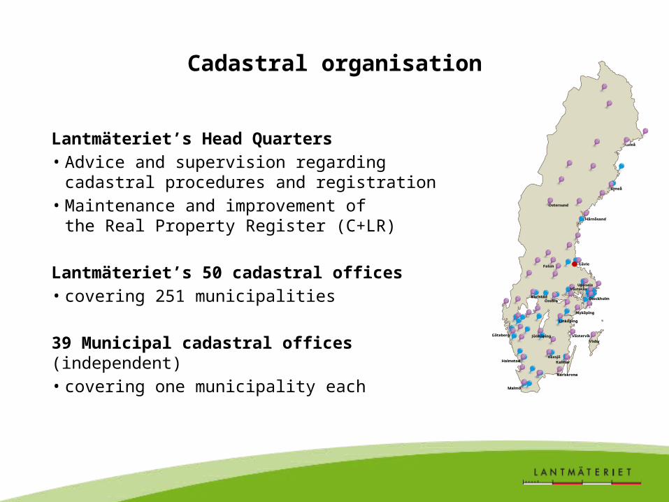
Cadastral organisation
Lantmäteriet’s Head Quarters• Advice and supervision regarding cadastral
procedures and registration• Maintenance and improvement of
the Real Property Register (C+LR)
Lantmäteriet’s 50 cadastral offices • covering 251 municipalities
39 Municipal cadastral offices (independent)• covering one municipality each

Development of the Real Property Register
1628-mapping
1827-1926land reform
1970-1995digitalisation
Ready

NDRK2017
National Digital Cadastral Index Map 2017
Appropriation Direction from Swedish Gov. related to INSPIRE:
• All data of the official Real Property Register to be kept by
Lantmäteriet
• Securing continuous updating of cadastral map data by the
municipal cadastral authorities
• Aligning textual and map information in the register
Deadline: 31st December 2017
Cadastral Services
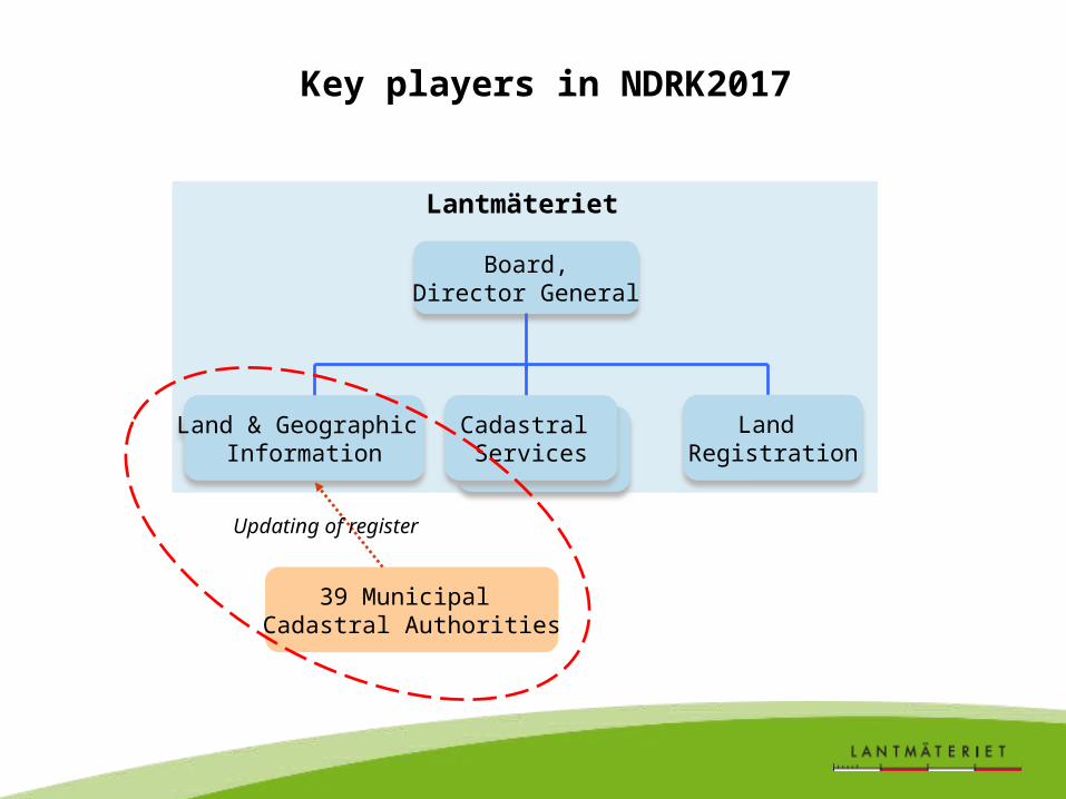
Key players in NDRK2017
Land & Geographic Information
Board,Director General
Land Registration
Cadastral Services
39 Municipal Cadastral Authorities
Lantmäteriet
Updating of register

NDRK2017 aims
• Continuous (daily) updating of the national cadastral map, to
match the updating of the textual information
• Focus objects: property units, use rights, development plans
• Improved interface for data exchange based on two current
system applications
• No more local (neither analogue nor digital) cadastral maps
kept by municipalities
• Simplified user access to all registry data via Lantmäteriet
Changes in legislation required per 1st January 2018

Municipal cadastral authorities with continuous (daily) updating
June 2012 June 2013 Nov. 20140
5
10
15
20
25
30
35
40
Property units
Use rights
Development plans

Updating applications and principlesNovember 2014
Property units Use rights Development plans
0
5
10
15
20
25
30
35
"Bryggan" (daily)
"Geometristöd i Ut-sikten" (daily)
Periodical updating (monthly)
No updating


”Geometristöd i Utsikten” (best option)
• Tailor-made solution for all municipal cadastral authorities• Based on ArcCadastre• Integrated in Lantmäteriet’s IT environment• All focus objects can be handled• Two-way communication between municipality and Lantmäteriet
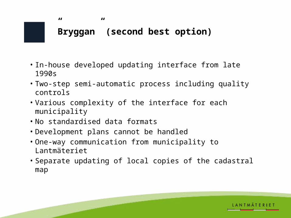
”Bryggan” (second best option)
• In-house developed updating interface from late 1990s• Two-step semi-automatic process including quality controls• Various complexity of the interface for each municipality• No standardised data formats• Development plans cannot be handled• One-way communication from municipality to Lantmäteriet• Separate updating of local copies of the cadastral map

Periodcial updating (to be phased out)
• New cadastral survey data etc. gathered monthly• Data sent to a special updating team at Lantmäteriet• No standardised data formats • Semi-manual updating of the national database• Separate updating of local copies of the cadastral map

Ongoing activities of NDRK2017
• Improving the second best application for continuous updating to handle all focus objects and to allow full data exchange (two-way communication)
• Assisting the municipalities still using periodical or no updating to start using either of the two applications for continuous updating
• Preparing for amendments to the registration legislation
… and discussing – as a separate initiative – future data exchange based on GML (no decision made yet)

KUF
Quality Development of Cadastral Data
Initiative originating from problems of missing data, contradictions, low accuracy etc. in the Real Property Register:
• Improving existing textual and map information on property
units and use rights
• Special focus on property boundaries in the cadastral map
• 2011-2015, budget 2-3 million Euro per year
• Cooperation with municipalities, Swedish Transport
Administration and Swedish Forestery Agency
Previous project ”ALBIN”, 2006-2009: 10 million Euro.Cost-benefit analysis showed good payback (factor 2.34)

Before

Mixed methodology for improving boundary data
Archive research, georeferencing, ortophoto comparison, field survey control…
… laser scanning, drones, crowd sourcing?

Archive research output
Information in cadastral documents
1. Coordinate lists connected to the national geodetic network >> direct use
2. Coordinate lists not connected to the national geodetic network >> GPS survey and transformation
3. Technical descriptions >> Polar, Orthogonal and other constructions

Before
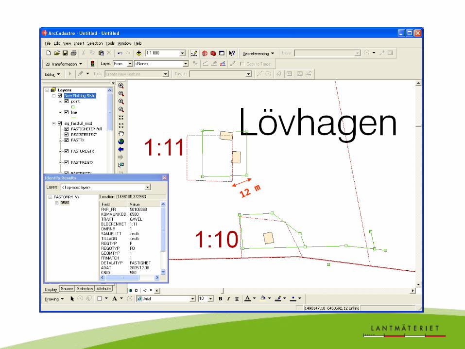
12 m

After

Boundary accuracy indication
Thank you!