05 cadastral system in poland ok - eurocadastre.org · into real estate cadastre, the cadaster is...
TRANSCRIPT
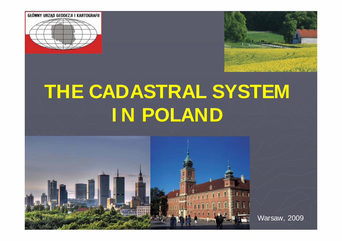
THE CADASTRAL SYSTEMIN POLAND
Warsaw, 2009
HISTORY OF THE CADASTRE IN POLAND
► The Polish real estate cadastre was formed under influence of cadastral systems applied in neighbouring countries: the Prussian and the Austrian Empires in the middle of the 19th century.
► In post partition period, i.e. after 1795 a part of the Polish state, which was included to Austria, was embraced by Austrian cadastre, while land of the Prussian partition – by Prussian cadastre.
► Real estates placed in the Russian partition were not embraced by a unified land cadastre. The lack of complete coverage with maps for this area was a major reason that hindered establishing of land cadastre. A family Estate of Zamoyski family (Ordynacja Zamojska) was an exception where there was established a detailed register modelled on Austrian cadastre.

The coverage of Prussian cadastre (in blue) amounts 40% and the coverage of the Austrian cadastre (in green) – 14%.
For the remaining part of the country, depicted in white colour, i.e. 46 % of the country’s area (the Russian partition), no cadastral documentation was prepared.
COVERAGE OF POLAND WITH CADASTRAL DOCUMENTATION

Fragment of a cadastral map (Prussian Cadastre)
Fragment of a cadastral map (Austrian Cadastre)
Fragment of a cadastral map (Russian Cadastre)

► 1935-1939 - works aimed at establishment of unified cadastral system were undertaken,
► the Act dated 26 March 1935 on Land Classification for Land Tax (‘fiscal classification’) - the beginning of system organization,
► the Decree of 1945 on the State Geodetic and Cartographic Service - the first legal act, which assumed a need for establishing and continuation of real estate cadastre in Poland,
► the Decree on land and building cadastre dated 24 September 1947 - the first legal regulation concerning the cadastre issued in Poland after II World War. Its legacies constituted about establishment of unified multi-purpose land and building cadastre for the whole area of Poland.
► the Decree of the Council of Ministers dated 4th June 1956 on Soil Quality Valuation - in this Decree the rules for conducting the soil quality valuation in Poland were defined. On the basis of this Decree the soil quality valuation was conducted in the whole country for the farm lands, private lands under forests and under water basins with area below 10 hectares.
Content was determined by the fiscal purposes. The ownership of real estate was treated marginally and they focused on possession mainly.
HISTORY OF THE CADASTRE IN POLAND (1935 – 1956)

REGISTER OF LAND AND BUILDINGS -REAL ESTATE CADASTRE
Register of land and buildings was named real estate cadastre in act dated 17 May 1989 - Geodetic and Cartographic Law (Journal of Laws of 2005 No. 240, pos. 2027 with further amendments): ‘until transformation of land and building register into real estate cadastre, the cadaster is understood as this register’ (art. 5a of the Act).
According to the art. 2, point 8 of the Act register of land and buildings (real estate cadastre) ‘is a uniform collection for the whole country of systematized, updated data on land, buildings and premises, their owners and other natural persons and corporate bodies holding these lands, buildings and premises’.
Data included in the register are basis for:
► economic planning,► spatial planning,► tax and fees assessment,► denotations in land and mortgage registers,► national statistics,► land management,► farm registry.
Main characteristics of the cadastral system in Poland
Land and Building Register:
responsibility of Surveyor General of Poland (Ministry of PublicAdministration and Internal Affairs)covers continuously the whole territory of Poland (312 000km2, 33mln cadastral parcels)consists of two parts – descriptive and graphical
Descriptive is numerical in 100%Graphical part is victories in 75%
maintenance is a governmental task but delegated to the selfgovernmental bodies linked to the other register concerning property data by the administrative procedures stipulated by the law supported by technical solutions. :
Land and Mortgage Register - Ministry of Justice Tax Register - Ministry of Finance

AUTHORITIES FOR LAND AND BUILDINGS REGISTER
Surveyor General of Polandcentral governmental administration unit
supervises the State policy within the scope of geodesy and cartography performs his tasks with the assistance of the Head Office of Geodesy and Cartography
Province heads (voivodes)control starostas’ (district chief officials) actions within the scope of these tasksperform their tasks with the assistance of Regional Inspectors for Geodetic and
Cartographic Supervision
Chiefs poviat officials (starostas)or Presidents of the city governed on district laws
run the real estate registerperform their tasks with the assistance of the poviat surveyors
475
16
CONTENT OF THE LAND AND BUILDINGS REGISTER
► land - its location, boundaries, area, kinds of grounds (land uses) and their soil quality, the denotations in land and mortgage registers or collections of documents,
► buildings - their location, designation, utility function and general technical data (year of completion of construction, number of storeys, material used in external walls of a building),
► premises - their location, utility function and utilizable area.
The land and building register also identifies:► the owner and, in the case of the State and communal land, other natural
persons or bodies corporate who hold the land and buildings or their parts,► the place of residence or the registered address of the owners and possessors
of real estates,► information on entering of the real properties or their parts to the historical
monuments register,► the value of the real estate (cadastral value, determined through Real Estate
Mass Appraisal).
The register of land and buildings (real estate cadastre) comprises information concerning:
CADASTRAL MAPS
Contents of a cadastral map:1. boundaries: of the State, units of fundamental three level territorial division,
cadastral complexes, cadastral sections, cadastral parcels,2. designations of boundary points, with distinguishing points which were
determined in proper procedure and with proper accuracy and among them –points solidly marked in terrain,
3. contours of land uses and their designations,4. contours of soil valuation classes and their designations,5. contours of buildings,6. numbers of cadastral parcels,7. boundaries of statistical areas and their designations,8. descriptive-informative data, and in particular:
a) names of the units of fundamental three level State territorial division,b) designations of cadastral unit and cadastral section,c) name of street, square, sacred spots, watercourse, water basins and other
physiographic objects,d) numbers of public roads given on the basis of regulations on public roads,e) reference and cadastral numbers of buildings.
Cadastral map - a large-scale map, which contains spatial cadastral data in the scale of 1:500, 1:1000, 1:2000 or 1: 5000 depending on degree of urbanization.

1. Information on land, buildings and premises are open to public and commonly accessible (restricted in cases when the data sets or documents include personal data)
2. The fees are collected for disseminated data sets and distributed extracts from the registers and directories as well as for copies of cadastral maps
3. Transposition of the INSPIRE Directive to the Polish legal system, according to the draft Act, all public organizations will be not charged cadastral data for realization of public tasks
Accessibility of data

UPDATING PROCEDURES
Data included in land and building register are subject to Data included in land and building register are subject to updating updating ex officio ex officio or on request or on request of interested persons, authorities and organizational unitsof interested persons, authorities and organizational units. .
Chief district officials are obliged by law to keep the real estate register updated.
The obligations with this regard are as follow:► entering changes to cadastral documentation promptly i.e. without
unnecessary delay,
► demanding from the engaged persons documents which constitute the basis for change in cadastral data,
► collecting and keeping notifications on changes together with source documents for changes,
► mandatory notifying Divisions of Land Books, taxs organs, public statistics, owners and possessors (who applied for changes)

PROVIDED SERVICES
Chief district officials distribute cadastral data in following forms:► computer printout cadastral map, register, directories, lists, specifications
and indexes► extracts from registers and directories► copies from cadastral map► computer files► information conveying orally and visually
The basic way of distribution of cadastral data by personal contact of interested persons with authority responsible for running land and building register.
In many cases, on initiative of local or regional self-government’s authorities, Internet portals, enabling dedicated and, in some scope, also public access for cadastral data, are established.

MODERNISATION OF LAND AND BUILDINGS REGISTER
► improving the quality of data and giving these data a standard shape► Integration of descriptive data with the cadastral map and converting
analogue register maps to a digital (vector) form (administrative procedure)
► supplementing survey registration dossiers with data concerning buildings and flats
The use is made from the orthophotomaps
Modernization is focused on:

INTEGRATING ELECTRONIC PLATFORM (IPE)
Integrating Electronic Platform (IPE) System enables exchange of data between land and buildings register and land and mortgage registry and tax register. Also it allows access to data from land and buildings registers for the needs of the other IT systems run by public administration bodies, verification of data in land and buildings registers with data held in PESEL (Universal Population Census Register) and REGON (National Official Register of Economic Subjects).
Data integration within IPE system
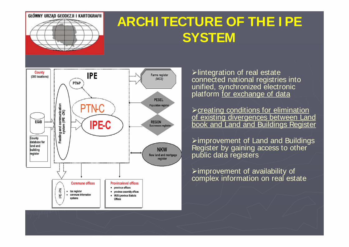
ARCHITECTURE OF THE IPE SYSTEM
lintegration of real estate connected national registries into unified, synchronized electronic platform for exchange of data
creating conditions for elimination of existing divergences between Land book and Land and Buildings Register
improvement of Land and Buildings Register by gaining access to other public data registers
improvement of availability of complex information on real estate

LINKS BETWEEN REGISTERS
Both registers - land and building register and land and mortgage register (land books), are two independent real estate data sets.
Land and building register contains full information of lands, buildings and premises, and limited information of real estate’s legal status.
Land and mortgage register contains real estate’s full legal status and limited information of real estate’s designation.
Land and mortgage register is maintained by local courts of justice (the land book divisions).
Currently 350 divisions run the land and mortgage register. It is estimated that about 60% of real estate is registered in land books.Land books are open to public.
Since 2003 on the basis of the Act dated 14 February 2003 on Migration of Land Book Contents to the Structure of Land and Mortgage Register kept in IT system the project of land book computerisation is being realized.
In most land books courts new land books are established and conducted at once in electronic form. The content of existing land books, conducted previously in written form, is transferred to electronic form (migration to the NKW system).
It is assumed that this process will be finished in 2010.
The contents of land books included in the NKW system is collected in Land and Mortgage Register Central Database, localized in the Main Centre of Data Processing of the Ministry of Justice.
Land and Mortgage Register
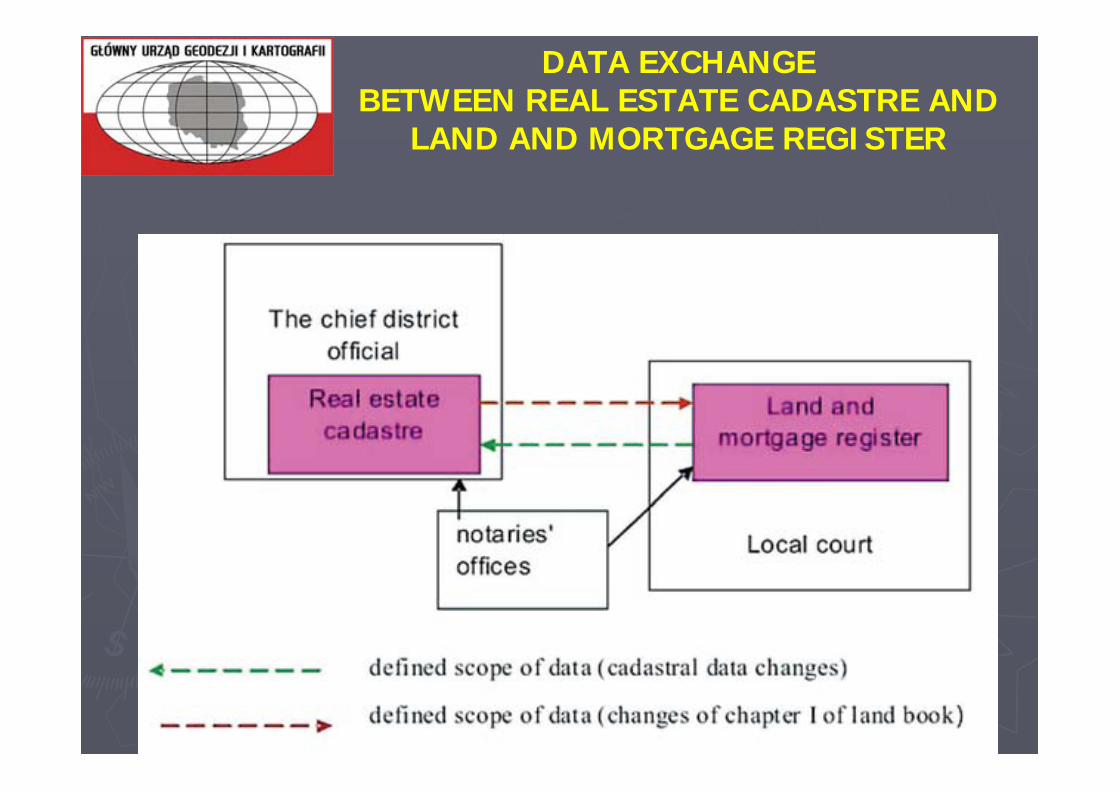
DATA EXCHANGE BETWEEN REAL ESTATE CADASTRE AND
LAND AND MORTGAGE REGISTER

Agricultural land are taxed with the agricultural tax.
The real estate tax register includes data on taxpayers and objects of taxation, which come particularly from information and declarations submitted by taxpayers and regulations on agricultural and forest tax, data contained in the land books, real estate cadastre and other records and registers.
LINKS BETWEEN CADASTRE AND TAXS REGISTER
The tax organs maintain the real estate tax register in an IT system for needs of assessment and collection of real estate tax, agricultural and forest tax.
The taxable base for real estate tax is:
► for lands – area of land,► for buildings or their parts – area of usable space of building,► for structures or their parts used for running business activities - value which is
defined in the regulations relating to income taxes assessed for the 1st of January of the tax year.

Cadastral system will be (to some extend) a part of the national spatial data infrastructure (SDI)
IEP is going to be included in the infrastructure
Cadastral parcels are distributed in the infrastructure
Services according to the INSPIRE directive will be available in SDI
SPATIAL DATA INFRASTRUCTURE and
CADASTER SYSTEM
National Spatial Data Infrastructure is operating on the three levels: central, provincial and district, cooperating together and providing services - from searching, trough giving access, to analyzing data.
Geoportal - an Internet based portal harmonious with regulations of INSPIRE Directive, playing a role of broker, allowing its users to access demanded geospatial information
The databases of the register of lands and buildings (cadastral data) and other large scale data bases are placed on the poviat level while the warehouses of the topographical data are stored on the regional level
Digital cadastral maps are stored also on the central level
SDI and CADASTER

Districts in which the Integrating Electronic Platform system was implemented after the“GEOPORTAL.GOV.PL”project
GEOPORTAL.GOV.PL
REMARKS
Goal of performed activities: To enable the cadastre to be performed in the newest technologies and modern administrative procedures
Further modernisation of land and building register to improve data quality
Further integration of the cadastral data with the data of land book (development of the IPE system)
Improvement of data distribution and services (via internet tools) –changes in law and new functionality implementation of the IT systems
Integration of the cadastral system into the SDI (cadastral parcel)
Changes in the organization of public administration in cadastre and geodesy

Thank you for attention
Head Office of Geodesy and Cartography
Wspólna 2 StreetWarsaw , PolandPhone: (22) 661 80 17 Fax: (22) 629 18 67 e-mail: [email protected]