toward a fire and haze early warning system for southeast asia · a clear need for a fire and haze...
TRANSCRIPT

ABSTRACT Smoke haze from forest fires is among South-east Asia’s most serious environmental problems and there is a clear need for a fire and haze early warning system (EWS) for the region. APEC Climate Center (APCC) has been collecting monthly dynamic prediction data produced by 16 institutions and has been producing 6-month lead multi-model ensem-ble (MME) climate forecasts every month. In this study, we developed four different statistical downscaling methods and assessed the forecast skill of the integrated forecast system over four provinces in Borneo Island. We developed a EWS pro-totype in which three-month precipitation (August to October) is predicted during April to July and the forecasted precipitation amount is then translated into four fire danger ratings based on the relationship between precipitation amount and CO2 emission. A needs assessment for early warning information was conducted through field surveys with resource managers at three provinces in Indonesia. A two-day workshop was held for the improvement of the EWS. Finally, the forest fire early warning information on Borneo Island created using the EWS will be provided though the hosting server in APCC.
KEYWORDS fire danger; seasonal forecasts; statistical down-scaling; dynamical downscaling; seasonal drought
1. Introduction
Smoke haze from forest fires is among Southeast Asia’s most serious environmental problems. Severe burning in Indo-nesia occurs only during years with anomalously low rainfall. Monitoring for these conditions is important, but has limited effectiveness because the burning is opportunistic. As a result, measures to prevent these fires and mitigate their impacts remains limited by the absence of long-lead early warning system (EWS). Severe burning conditions, therefore, need to be forecast weeks to months in advance for any prevention to be effective. In this context, little of the progress made in seasonal forecasting has been applied to fire early warning in Indonesia and there is a clear need for a fire and haze EWS for the region. The project builds upon current fire danger rating systems by providing forecasts at a longer lead-time using sea-sonal forecast data maintained at APCC, a time-scale that is more relevant and useable for decision makers. The final objec-tive of the project is to develop a prototype of fire danger EWS by considering field survey results and conducting a training workshop.
Toward a Fire and Haze Early Warning System for Southeast Asia
Jin Ho YOOa, Jaepil CHOa , Saji HAMEEDb, Robert FIELDc, Kok Foo KWANd, Israr ALBARe
J. H. Yoo, J. Cho, S. Hameed, R. Field, K. F. Kwan, & I. Albar
a APEC Climate Center, 12 Centum 7-ro, Haeundae-gu, Busan,
612-020, Republic of Korea
b Aizu University, street, Aizu-Wakamatsu City, Fukushima-ken
965-8580, Japan
c Columbia University, 116th Street and Broadway, New York,
10027, USA
d Malaysian Meteorological Department, Petaling Jaya, Selangor,
47301, Malaysia
e Department of Forestry, Gedung Manggala Wanabakti Blok,
Jakarta, 10207, Indonesia
Corresponding author. Email: [email protected];
Tel: +82-51-745-3994, Fax: +82-51-745-3999.
APN Project Reference: ARCP2013-10CMY-Yoo / Received: January 2016 / Published online: March 2016
Available online at APN E-Lib: http://www.apn-gcr.org/resources
HIGHLIGHTS
• Four different downscaling methods were devel-oped and integrated into the prototype of EWS in order to improve the predictability.
• Long-term predictability of monthly precipitation for the four regions within Borneo Island was evaluated.
• APCC led a two-day workshop in Malaysia, including hands-on training sessions on statistical downscaling and prototype.
• Needs assessment for early warning informa-tion was conducted through field surveys with resource managers.
• Monthly precipitation forecasts for dry season (August to October) over 4 provinces in Borneo Island showed good predictability less than four-month lead time by showing temporal correlation coefficients (TCCs) greater than 0.5 in all prov-inces.
ARCP2013-10CMY-Yoo
FEATURED ARTICLES 13
ARCP2013-10CMY-YOO
2. Methodology
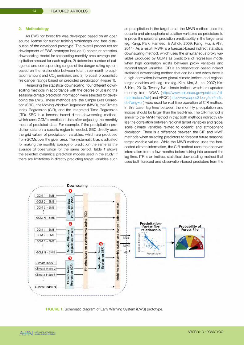
An EWS for forest fire was developed based on an open source license for further training workshops and free distri-bution of the developed prototype. The overall procedures for development of EWS prototype include 1) construct statistical downscaling model for forecasting monthly area-average pre-cipitation amount for each region, 2) determine number of cat-egories and corresponding ranges of fire danger rating system based on the relationship between total three-month precipi-tation amount and CO2 emission, and 3) forecast probabilistic fire danger ratings based on predicted precipitation (Figure 1).
Regarding the statistical downscaling, four different down-scaling methods in accordance with the degree of utilising the seasonal climate prediction information were selected for devel-oping the EWS. These methods are: the Simple Bias Correc-tion (SBC), the Moving Window Regression (MWR), the Climate Index Regression (CIR), and the Integrated Time Regression (ITR). SBC is a forecast-based direct downscaling method, which uses GCM’s prediction data after adjusting the monthly mean of predicted data. For example, if the precipitation pre-diction data on a specific region is needed, SBC directly uses the grid values of precipitation variables, which are produced from GCMs over the given area. The systematic bias is adjusted for making the monthly average of prediction the same as the average of observation for the same period. Table 1 shows the selected dynamical prediction models used in the study. If there are limitations in directly predicting target variables such
as precipitation in the target area, the MWR method uses the oceanic and atmospheric circulation variables as predictors to improve the seasonal prediction predictability in the target area (eg. Kang, Park, Hameed, & Ashok, 2009; Kang, Hur, & Ahn, 2014). As a result, MWR is a forecast-based indirect statistical downscaling method, which uses the simultaneous proxy var-iables produced by GCMs as predictors of regression model when high correlation exists between proxy variables and regional target variables. CIR is an observation-based indirect statistical downscaling method that can be used when there is a high correlation between global climate indices and regional target variables with lag time (eg. Kim, Kim, & Lee, 2007; Kim & Kim, 2010). Twenty five climate indices which are updated monthly from NOAA (http://www.esrl.noaa.gov/psd/data/cli-mateindices/list/) and APCC (http://www.apcc21.org/ser/indic.do?lang=en) were used for real time operation of CIR method. In this case, lag time between the monthly precipitation and indices should be larger than the lead-time. The CIR method is similar to the MWR method in that both methods indirectly uti-lise the correlation between regional target variables and global scale climate variables related to oceanic and atmospheric circulation. There is a difference between the CIR and MWR methods when selecting predictors to forecast future seasonal target variable values. While the MWR method uses the fore-casted climate information, the CIR method uses the observed information from a few months before taking into account the lag time. ITR is an indirect statistical downscaling method that uses both forecast and observation-based predictors from the
Figure 1. Schematic diagram of Early Warning System (EWS) prototype.
FEATURED ARTICLES14
ARCP2013-10CMY-YOO

MWR and CIR methods, respectively. As a result, it can be used only when the MWR and CIR methods simultaneously select predictors for a particular target period.
We used the same regions from previous research by Field and Shen (2008) for developing and evaluating the statistical downscaling methods. The regions include Southern Sumatra (SSUM), Central Sumatra (CSUM), Eastern Kalimantan (EKAL) and Southern Kalimantan (SKAL). However, we decided the administrative boundary for managerial purpose of the EWS and four provinces in Borneo Island were used in this study (Figure 2).
Second, an analysis of the threshold levels for the study regions was conducted in order to translate the predicted precipitation amount to the fire danger ratings. If the amount of precipitation dips below the threshold level, this predicts an increased risk for severe burning, carbon emissions, and transboundary haze. It is necessary to connect the forecasted precipitation to the possible EWS index based on region-spe-cific threshold level. We used the relationship between region-average ASO precipitation and carbon emission data. The region-average monthly precipitation and carbon emission data were derived from APHRODITE’s Water Resources (http://
www.chikyu.ac.jp/precip/) and Global Fire Emissions Database (http://www.globalfiredata.org/) webpages, respectively. At first, we attempted to determine the ranges for each category using a segmented regression method. However, the result-ing threshold precipitation was too low, which increased the likelihood of extreme carbon emissions being predicted due to scattered data. As a result, we set the threshold value manually based on the time series of three-month accumulated monthly precipitation and carbon emissions.
Based on an earlier version of the prototype, APCC led a workshop including hands-on training sessions on statistical downscaling and the prototype. After the training, we improved the predictor selection algorithm for the MWR and CIR meth-ods in order to avoid overfitting in real-time forecasts. The con-cepts of both cross-validation and split-validation were applied in order to prevent overfitting problems. The Leave-one-out Cross-Validation (LOOCV) technique was applied to the obser-vation period (1983–2013). In other words, when predicting target variables for a specific target period (year/month), all pre-dictors for the same target period are removed from the model construction procedure in order to reproduce the same con-ditions as real time forecasting. For example, when predicting
Model Institution Raw Resolution Ensemble Size
CANCM3 Meteorological Service of Canada (Canada)
T63L31 (AGCM)1.41°× 0.94° L40 (OGCM)
10
CANCM4 Meteorological Service of Canada (Canada)
75.37 10
NASA National Aeronautics and Space Administration (USA)
220.1 10
NCEP Climate Prediction Center - NCEP/NWS/NOAA (USA)
11.41 17
PNU Pusan National University (Republic of Korea)
320.41 4
POAMA Centre for Australian Weather and Climate Research/
Bureau of Meteorology (Australia)
T47L17 (AGCM)0.5–1.5°LAT × 2°Lon, L25 (oGCM)
30
Table 1. Description of dynamical seasonal prediction models used in the study.
Figure 2. Selected regions for developing statistical downscaling methods and early warning system.
FEATURED ARTICLES 15
ARCP2013-10CMY-YOO

for January 1983, only predictors from January 1984 to 2013 are utilised in constructing the regression model. Predictions are made in the same way for the rest of the simulation period. For each cross-validation process, the split validation approach was applied, and then the best predictors that showed con-sistent performance for both training and verification periods were finally selected. In addition, a needs assessment for early warning information was conducted through field surveys with resource managers. Based on the survey results, we decided to use four danger rating categories and six-month lead time in developing the EWS prototype by considering ASO precipita-tion as a trigger for forest fire. As a result, we are able to issue an ASO precipitation forecast from April to July.
3. Results and Discussions
Only individual forecast models that show consistent selection of predictors through cross and split validation pro-cedures with significant forecast skill score (TCC) were finally selected for the EWS. The SBC method, which is based on dynamic prediction data, shows the highest model selection and is followed by statistical downscaling methods such as MWR and CIR/ITR. In most of the months, when the selected models are based on dynamic model predictions (SBC), there is a decreasing trend in TCC values as the lead times increase. Table 2 and Figure 3 show the TCC values for each month according to changes in lead time. The TCC values were cal-culated using MME with the condition that forecasts are issued every month. Figure 4 shows the comparison of observed and forecasted monthly precipitation for August issued in April using all selected individual models. Equal weight average of indi-vidual forecasts were used for estimating MME and the result showed a trend that lower precipitations were overestimated and higher precipitations were underestimated. Finally, monthly precipitation forecast for dry season (August to October) over four provinces in Borneo Island showed good predictability less than four-month lead time by showing temporal correlation
coefficient (TCC) greater than 0.5 in all provinces. When we consider ASO precipitation as a trigger for forest fire, we can issue an ASO precipitation forecast from April to July because we are using 6-month lead forecast data in developing proto-type EWS.
In order to translate forecasted precipitation into fire danger ratings, four categories (Extreme, High, Moderate and Low) were established based on the results from the field survey. We designed a template for delivering forecast information on both precipitation and probability of forest fire for ASO period. Figure 5 shows the forecast summary for monthly precipita-tion and probability of forest fire in Selatan region for August to October in 1997, which was issued in April, 1997. The graph shows the graphical information for previous and current years by providing climatology (blue), observed (red), and forecasted precipitaion (black). The boxplot in the figure shows the var-iations of predicted values by individual models. The dots at the end of the boxplots represent outliers defined by less than Q1 − 1.5×IQR or greater than Q3 + 1.5×IQR. Where, Q1, Q3, and IQR are 25th and 75th percentiles, and difference between Q3 and Q1, respectively. The figure shows that severe drought during August to October, 1997 was closely predicted in Sela-tan region. The bottom-left table shows the overall summay of one-month lead forecast skill scores based on the long-term period with monitoring data. Skill score with resepect to TCC according to different lead time was presented in Table 2. The used performance measures include TCC and NRMSE, which can be used for continous variables and Accuracy and Heidke Skill Score (HSS), which in turn can be used for category fore-casts. For calculating Accuracy and HSS, we equally divided the observed monthly precipitation into four categories (25% for each). Finally, the forecast information for four regions within Borneo Island will be issued each month from April to July and the forecast summary will be posted on the APCC’s web host-ing server (http://www.apcc21.org/eng/html/apn.jsp).
Month Region 1 month 2 month 3 month 4 month 5 month 6 month
JAN
Barat 0.52 0.52 0.52 0.52 0.52 0.52
Selatan 0.69 0.69 0.63 0.49
Tengah 0.42 0.42 0.42 0.42
Timur 0.75 0.72 0.69 0.59 0.56 0.56
FEB
Barat 0.68 0.68 0.63 0.45 0.45
Selatan 0.72 0.68 0.59 0.5 0.5
Tengah
Timur 0.71 0.68 0.62 0.63 0.62 0.63
MAR
Barat 0.8 0.69 0.7 0.42
Selatan 0.82 0.82 0.76 0.55 0.55 0.45
Tengah 0.57 0.43
Timur 0.68 0.69 0.67 0.59 0.57 0.55
FEATURED ARTICLES16
ARCP2013-10CMY-YOO

Month Region 1 month 2 month 3 month 4 month 5 month 6 month
APR
Barat 0.68 0.68 0.63 0.43 0.43 0.43
Selatan 0.49 0.49
Tengah 0.65 0.51
Timur 0.74 0.72 0.72 0.69 0.69 0.62
MAY
Barat 0.77 0.75 0.52 0.52 0.52 0.52
Selatan 0.68 0.64 0.61 0.51 0.52 0.52
Tengah 0.8 0.85 0.83 0.83 0.71 0.71
Timur 0.65 0.67 0.72 0.72 0.57
JUN
Barat 0.51 0.51
Selatan 0.58 0.58 0.41
Tengah
Timur 0.81 0.81 0.69 0.52 0.52
JUL
Barat 0.62 0.62 0.64 0.6 0.45 0.48
Selatan 0.6 0.59 0.58 0.58 0.47 0.47
Tengah 0.55 0.52 0.55 0.58 0.43 0.43
Timur 0.53 0.53 0.54 0.56 0.52
AUG
Barat 0.7 0.69 0.68 0.67 0.67 0.65
Selatan 0.76 0.76 0.75 0.75 0.74 0.7
Tengah 0.67 0.66 0.67 0.68 0.68 0.62
Timur 0.57 0.56 0.55 0.54 0.49
SEP
Barat 0.63 0.59 0.59 0.59 0.57 0.53
Selatan 0.54 0.54 0.53 0.51 0.52 0.54
Tengah 0.6 0.61 0.62 0.63 0.64 0.61
Timur 0.66 0.64 0.63 0.61 0.58 0.57
OCT
Barat 0.7 0.61 0.64 0.47 0.43
Selatan 0.62 0.59 0.55 0.51 0.51 0.5
Tengah 0.6 0.57 0.53 0.53 0.46
Timur 0.58 0.57 0.51 0.45
NOV
Barat 0.75 0.71 0.65 0.67 0.69 0.67
Selatan 0.58 0.56 0.56 0.59 0.58 0.58
Tengah 0.71 0.7 0.68 0.68 0.68
Timur 0.68 0.5 0.5 0.5
DEC
Barat 0.63 0.63 0.63 0.63 0.55 0.55
Selatan 0.69 0.62 0.62 0.62 0.62
Tengah 0.69 0.63 0.54 0.49 0.45
Timur 0.63 0.63
Table 1. Temporal correlation coefficients (TCC) according to changes in lead time for predicting precipitation using multi-model ensemble (MME) average.
FEATURED ARTICLES 17
ARCP2013-10CMY-YOO

Figure 3. Temporal correlation coefficients (TCC) according to changes in lead time for predicting precipitation in Barat (a), Selatan (b), Tengah (c), and Timur (d) regions using multi-model ensemble (MME) average.
Figure 4. Timeseries (left) and scatter plot (right, next page) of monthly precipitation for August issued in April, where B_, M_, C_, I_ indicate SBC, MWR, CIR, ITR downscaling methods, respectively.
FEATURED ARTICLES18
ARCP2013-10CMY-YOO
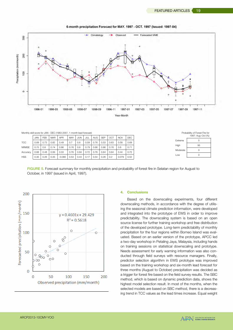
Figure 5. Forecast summary for monthly precipitation and probability of forest fire in Selatan region for August to October, in 1997 (issued in April, 1997).
4. Conclusions
Based on the downscaling experiments, four different downscaling methods, in accordance with the degree of utilis-ing the seasonal climate prediction information, were developed and integrated into the prototype of EWS in order to improve predictability. The downscaling system is based on an open source license for further training workshop and free distribution of the developed prototype. Long-term predictability of monthly precipitation for the four regions within Borneo Island was eval-uated. Based on an earlier version of the prototype, APCC led a two-day workshop in Petaling Jaya, Malaysia, including hands on training sessions on statistical downscaling and prototype. Needs assessment for early warning information was also con-ducted through field surveys with resource managers. Finally, predictor selection algorithm in EWS prototype was improved based on the training workshop and six-month lead forecast for three months (August to October) precipitation was decided as a trigger for forest fire based on the field survey results. The SBC method, which is based on dynamic prediction data, shows the highest model selection result. In most of the months, when the selected models are based on SBC method, there is a decreas-ing trend in TCC values as the lead times increase. Equal weight
Monthly skill score for JAN - DEC (1983-2007, 1-month lead forecast)
JAN FEB MAR APR MAY JUN JUL AUG SEP OCT NOV DEC
TCC 0.69 0.73 0.82 0.49 0.7 0.6 0.59 0.76 0.53 0.63 0.58 0.69
NRMSE 0.75 0.8 0.74 0.86 0.76 0.8 0.79 0.66 0.86 0.76 0.8 0.71
Accuracy 0.68 0.48 0.56 0.33 0.76 0.84 0.72 0.76 0.64 0.64 0.44 0.72
HSS 0.35 0.26 0.35 -0.085 0.53 0.44 0.17 0.54 0.26 0.2 0.079 0.52
Probability of Forest Fire for 1997: Aug~Oct (%)
Extreme 5
High 95
Moderate 0
Low 0
FEATURED ARTICLES 19
ARCP2013-10CMY-YOO

averages of individual forecasts were used for estimating MME and the result showed a decrease trend in yearly variation. A template was designed for delivering forecast information on both precipitation and probability of forest fire for ASO period. Monthly precipitation forecast for dry season (August to October) over four provinces in Borneo Island showed good predictability less than four-month lead time by showing TCC greater than 0.5 in all provinces. The forest fire early warning information on Southeast Asia created using the EWS will be provided though the hosting server in APCC.
Acknowledgement
We are grateful to APN for the financial support for this pro-ject and we are also grateful to the Malaysian Meteorological Department for financial and logistical support for the work-shop in Petaling Jaya, Malaysia, June 9–10, 2015.
References
Field, R. D., & Shen, S. S. P. (2008). Predictability of carbon emissions from biomass burning in Indonesia from 1997 to 2006. Journal of Geophysical Research, 113(G4), G04024. http://doi.org/10.1029/2008JG000694
Kang, H., Park, C.-K., Hameed, S. N., & Ashok, K. (2009). Statistical downscaling of precipitation in Korea using multimodel output variables as predictors. Monthly Weather Review, 137(6), 1928–1938. http://doi.org/10.1175/2008MWR2706.1
Kang, S., Hur, J., & Ahn, J.-B. (2014). Statistical downscaling methods based on APCC multi-model ensemble for sea-sonal prediction over South Korea. International Journal of Climatology, 34(14), 3801–3810. http://doi.org/10.1002/joc.3952
Kim, M.-K., & Kim, Y.-H. (2010). Seasonal prediction of monthly precipitation in China using large-scale climate indices. Advances in Atmospheric Sciences, 27(1), 47–59. http://doi.org/10.1007/s00376-009-8014-x
Kim, M.-K., Kim, Y.-H., & Lee, W.-S. (2007). Seasonal predic-tion of Korean regional climate from preceding large-scale climate indices. International Journal of Climatology, 27(7), 925–934. http://doi.org/10.1002/joc.1448
FEATURED ARTICLES20
ARCP2013-10CMY-YOO