toponymic guidelines for map editors and other editors 1 languages 1.1 general remarks 2 the english...
TRANSCRIPT

E/CONF.105/32/CRP.32
* E/CONF.105/1
** Prepared by Catherine Cheetham, Permanent Committee on Geographical Names
23 June 2017
Original: English
11th
United Nations Conference on the
Standardization of Geographical Names
New York, 8 -17 August 2017
Item 9( e ) of the provisional agenda* National standardization: toponymic guidelines for map editors and other editors
Toponymic guidelines for map editors and other editors
Submitted by United Kingdom of Great Britain and Northern Ireland **

Contents 1 Languages 1.1 General remarks 2 The English Language in the United Kingdom 2.1 General remarks 2.2 Alphabet 2.3 Spelling of English language geographical names 2.4 Pronunciation of English language geographical names 3 The Gaelic Language 3.1 General remarks 3.2 Alphabet 3.3 Spelling of Gaelic language geographical names 3.4 Pronunciation of Gaelic language geographical names 4 The Welsh Language 4.1 General remarks 4.2 Alphabet 4.3 Spelling of Welsh language geographical names 4.4 Pronunciation of Welsh language geographical names 5 Other Languages 5.1 General remarks 6 Geographical Names: Standardization and Portrayal 6.1 General remarks 6.2 Geographical names in Scotland 6.3 Geographical names in Wales 6.4 Geographical names in Northern Ireland 7 Source Materials 7.1 Ordnance Survey 7.2 Ordnance Survey of Northern Ireland 7.3 Other major recent source materials 8 Glossary of appellatives, adjectives and other words relevant to geographical names 8.1 Gaelic glossary 8.2 Welsh glossary 8.3 Scots glossary 9 Abbreviations encountered in official mapping 10 Geopolitical Terminology 10.1 Timeline 10.2 Definitions 10.2.1 United Kingdom of Great Britain and Northern Ireland 10.2.2 Great Britain 10.2.3 British 10.2.4 Crown Dependencies 11 Population and Area 11.1 England; Scotland; Wales; Northern Ireland 11.2 Cities and Towns 12 Administrative Divisions 12.1 General Information 12.2 England 12.3 Scotland 12.4 Wales 12.5 Northern Ireland
3
1 Languages 1.1 General remarks The English language is the only language relevant to the United Kingdom as a whole. In certain parts of the United Kingdom, other languages are locally relevant alongside English. These languages are Gaelic, Welsh, Cornish, Scots, and Irish – plus a number of more recently arrived languages such as Punjabi1.
2 The English language in the United Kingdom 2.1 General remarks English is a Germanic language taxonomically located within the Indo-European family of languages. Its origins stem from the Anglo-Saxon colonisations of Britain, which took place following the final withdrawal of the Romans, accomplished by AD 410. These colonisations, cemented over much of Britain from the 5th century AD onwards, involved the following peoples:
Angles, originating from the Schleswig and Flensburg area in northern Germany and settling in Northumbria (= much of England north of the river Humber), Mercia (= much of the English Midlands) and East Anglia
Saxons, originating from Old Saxony (roughly the territory in northern Germany between the lower courses of the rivers Weser and Elbe), and settling in Wessex (= approximately present-day Somerset, Dorset and Wiltshire), Sussex and Essex
Jutes, originating from Jutland (northern Schleswig in Germany and southern Jylland in Denmark), and settling in Kent and southern Hampshire.
The Anglo-Saxon colonisations from the 5th century established the language that has come to be known as Old English. This was subsequently influenced by the Scandinavian invasions of the 8th-9th centuries, and then following the Norman invasions of the 11th century it was also heavily influenced by Norman French, developing into what has become known as Middle English (the language used by Geoffrey Chaucer in the 14th century). From the 15th and 16th centuries a grammatically simpler language began to emerge; this was the origin of today’s Modern English. The impact of Modern English was enhanced by the advent of the printing press; Johannes Gutenberg’s original mid-15th century German model was replicated in England by Thomas Caxton in (probably) 1476. The playwright William Shakespeare, writing just over 100 years later around the turn of the 17th century, wrote in this early variety of Modern English, and the Church of England’s Authorised King James Bible of 1611 was also published in this style. Later, Samuel Johnson’s 1755 Dictionary of the English Language was a key factor in accelerating the process of orthographical standardization. The keystone of Modern English is its Germanic roots and its incorporation of Germanic, Greek and Latin vocabulary. The principal overall characteristics of Modern English are its flexibility and its capacity to adapt to changing circumstances. For more on the English language see the Wikipedia article entitled English language available at the webpage http://en.wikipedia.org/wiki/English_language and also the website http://www.englishlanguageguide.com.
1 For Gaelic, see Sections 3 and 6.2. For Welsh see Sections 4 and 6.3. For the remaining languages see
Section 5.1.

2.2 Alphabet The alphabet of the English language consists of 26 letters; 21 letters representing consonant sounds and 5 letters representing vowel sounds. A a J j S s B b K k T t C c L l U u D d M m V v E e N n W w F f O o X x G g P p Y y H h Q q Z z I i R r
The five vowels in this inventory are: A a, E e, I i, O o, U u. 2.3 Spelling of English language geographical names The orthography of the English language is standardized but can nonetheless be problematic. There are no fixed rules for the spelling of English language geographical names, except that individual words within a name will usually – but not always – begin with an upper-case letter. Spellings should be taken from the sources noted in Section 7 of this paper, particularly the sources in Sections 7.1 and 7.2. 2.4 Pronunciation of English language geographical names The pronunciation of English language geographical names, and indeed of the English language in general, is not easy to indicate. The 26 letters of the alphabet are obliged to represent 44 different phonemes2. Each name has its own pronunciation, and indeed there may be more than one acceptable pronunciation if local dialectal forms of English come into play. The spelling of a geographical name as found in the sources listed in Sections 7.1 and 7.2 of this paper may not be a wholly reliable guide as to its pronunciation.
3 The Gaelic language3 3.1 General remarks Gaelic (Gàidhlig) is a Celtic language taxonomically located within the Indo-European family of languages. It forms part of the Goidelic branch of the Celtic languages, along with Irish and Manx. Descended from Old Irish, Gaelic has probably been spoken in Scotland since Roman times. From an initially widespread geographical and social distribution in Scotland Gaelic began to decline from the 13th-14th centuries, often the victim of the advance of Middle English into Scotland4. Regular conflicts with England, and the Highland Clearance programme of the 18th century, hastened the decline of the language. A rich oral Gaelic tradition survived, however, and the language did achieve some recognition when the Bible was first translated into Gaelic in
2 44 is the number of phonemes recorded in many dialects of English, though some have more. See
http://www.englishlanguageguide.com/english/pronunciation. 3 This section relates to Scottish Gaelic; for information on Irish Gaelic see Section 5.2.
4 For more on Middle English see Section 2.1. Note that Middle English as spoken in Scotland went on to
develop as much into Scots (see Section 5.1) as into Modern English.

5
1767. At that juncture some 20% of the population of Scotland was recognised as being monolingual in Gaelic; that figure has steadily declined to zero. Despite more recent attempts at reviving the language the 2011 census showed that only about 1.1% of the population of Scotland (58,000 people) speak Gaelic well, (a decline of 0.1% of the population since the 2001 census) and fewer than 2% of the population had any familiarity with Gaelic at all5. The present geographical distribution of the language is weighted heavily towards western Scotland, with the greatest concentrations in the Outer Hebrides (Western Isles) and on Skye and Tiree. Attempts to halt the decline in the use of Gaelic have included granting the language official recognition through the Gaelic Language (Scotland) Act of April 20056 and establishing the statutory Bòrd na Gàilidh, designed to secure the status of the language7. Gaelic is today also promoted in education, in the media, and by the deployment of bilingual road signage and railway station names8. In 2001 the United Kingdom ratified the European Charter for Regional or Minority Languages in respect of Gaelic. 3.2 Alphabet The alphabet of the Gaelic language consists of 18 letters; 13 letters representing consonant sounds and 5 letters representing vowel sounds.
A a G g O o
B b H h P p
C c I i R r
D d L l S s
E e M m T t
F f N n U u
The 5 vowel letters denote 10 vowel sounds, the grave accent being used to indicate vowel length: A a, À à, E e, È è, I i, Ì ì, O o, Ò ò, U u, Ù ù. The acute accent has in the past also occasionally been used on vowels but this is no longer used in modern spelling. 3.3 Spelling of Gaelic language geographical names For the rules concerning the spelling of Gaelic language geographical names, please consult the website of the Ordnance Survey at the following webpage: https://www.ordnancesurvey.co.uk/resources/historical-map-resources/gaelic-language.html 3.4 Pronunciation of Gaelic language geographical names For the rules concerning the pronunciation of Gaelic language geographical names, please consult https://www.ordnancesurvey.co.uk/resources/historical-map-resources/gaelic-language.html. Also of interest in this regard is the Wikipedia article entitled Scottish Gaelic phonology available at the webpage http://en.wikipedia.org/wiki/Scottish_Gaelic_phonology.
5 See https://www.nrscotland.gov.uk/files/statistics/gaelic-rep-english-commentary.pdf
6 See http://www.opsi.gov.uk/legislation/scotland/acts2005/asp_20050007_en_1#pb5-l1g10.
7 See http://www.gaidhlig.org.uk/
8 See http://www.scot-rail.co.uk/page/Gaelic+Station+Names
4 The Welsh language 4.1 General remarks Welsh (Cymraeg) is a Celtic language taxonomically located within the Indo-European family of languages. It forms part of the Brythonic branch of the Celtic languages, along with Breton and Cornish9. It originated as Old Welsh in the 6th century AD, developed into Middle Welsh in the 12th century, and later gradually evolved into Modern Welsh – particularly with the publication in 1588 of William Morgan’s Welsh language Bible. The arrival of English workers during the Industrial Revolution, coupled with the inferior legal status of the Welsh language vis-à-vis English, caused a drop in the number of people speaking Welsh as their first language, a decrease which lasted through much of the 19th and 20th centuries. But from the late 20th century conscious efforts were made to revive Welsh, and in 1993 the Welsh Language Act gave the language official status and parity with English. The Act also established the Welsh Language Board (Bwrdd yr Iaith Gymraeg), a body with statutory powers, which has since 2012 been known as the Welsh Language Service10. The number of Welsh speakers stabilised, helped by the fact that since 2000 the teaching of Welsh has been compulsory in schooling up to the age of 16. The annual population survey of 2016 recorded 27% claiming some understanding of Welsh11. The geographical distribution of Welsh is concentrated in the rural west of the country, especially in Anglesey, Gwynedd, Ceredigion and Carmarthenshire. Most road signs in Wales are now bilingual. In 2001 the United Kingdom ratified the European Charter for Regional or Minority Languages in respect of Welsh. 4.2 Alphabet The alphabet of the Welsh language consists of 28 letters; 21 letters representing consonant sounds and 7 letters representing vowel sounds. Eight of the letters representing consonant sounds are digraphs.
A a NG ng R r
B b H h RH rh
C c I i S s
CH ch L l T t
D d LL ll TH th
DD dd M m U u
E e N n W w
F f O o Y y
FF ff P p
G g PH ph
The seven vowels in this inventory are: A a, E e, I i, O o, U u W w, Y y. A circumflex may be used on vowels; this indicates vowel length.
9 The term Brythonic is related to Britannic; see also Section 10.2.3.
10 The Welsh Language Service’s website is at http://www.welsh-language-board.org.uk/. See also
Section 6.3. 11
https://statswales.gov.wales/Catalogue/Welsh-Language/annualpopulationsurveyestimatesofpersonsaged3andoverwhosaytheycanspeakwelsh-by-localauthority-measure.
7
4.3 Spelling of Welsh language geographical names For the rules concerning the spelling of Welsh language geographical names, please consult the very useful e-book entitled The Welsh origins of place names in Britain, which can be found on the website of the Ordnance Survey at the following webpage: https://www.ordnancesurvey.co.uk/docs/ebooks/guide-to-welsh-origins-of-place-names.pdf
4.4 Pronunciation of Welsh language geographical names For the rules concerning the pronunciation of Welsh language geographical names, please consult the very useful e-book entitled The Welsh origins of place names in Britain, which can be found on the website of the Ordnance Survey at the following webpage: https://www.ordnancesurvey.co.uk/docs/ebooks/guide-to-welsh-origins-of-place-names.pdf. Also of interest in this regard is the Wikipedia article entitled Welsh phonology available at the webpage http://en.wikipedia.org/wiki/Welsh_phonology.
5 Other Languages 5.1 General remarks Apart from English, Gaelic and Welsh, three other languages are also very well established in the United Kingdom and are currently recognised as living languages under the European Charter for Regional or Minority Languages:
Cornish (found in Cornwall). This Celtic language (self-designation = Kernewek or Kernowek) has been resuscitated in recent decades and there are now perhaps 3000 people with rudimentary language skills at least, some 300 of whom can use Cornish effectively for everyday purposes. In May 2008 a standard orthography for Cornish, called the Standard Written Form (SWF), was approved
12. Cornish gained recognition as a living language under the European Charter in 2002.
Scots (found in Scotland, where it is sometimes termed Lowland Scots; also found in Northern Ireland, where it is termed Ulster Scots). This is a Germanic language, not to be confused with the Celtic language known as Gaelic. The number of speakers of Scots is very difficult to determine; a combined total of 100,000 in Scotland and Northern Ireland may be a reasonable estimate. Scots gained recognition as a living language under the European Charter in 2001
13.
Irish or Irish Gaelic (self-designation = Gaeilge; found in Northern Ireland). This forms part of the Goidelic branch of the Celtic language and is closely related to Scottish Gaelic (see Section 3). It is the first official language of neighbouring Ireland, and according to the 2011 United Kingdom census it is also relevant to almost 185,000 people in Northern Ireland (= 10.65% of the province’s population, an increase of 0.25% since the 2001 census), of whom 105,000 have some level of fluency. Since 1998 Irish has been promoted in education in Northern Ireland and it is an officially recognised minority language in the province. In 2001 Irish gained recognition in Northern Ireland as a living language under the European Charter
14.
British Sign Language was recognised as an official minority language in 2003, and has an estimated 150,000 users.
Languages relating to more recent immigration into the United Kingdom, especially from the South Asian sub-continent during the past half-century or so, are also significant in some
12
See the webpage http://kernowek.net/Specification_Final_Version.pdf. 13
For more information on the Scots language see The Scots Language in education in Scotland at: http://www1.fa.knaw.nl./mercator/regionale_dossiers/PDFs/scots_in_scotland.PDF. 14
For more information on Irish in Northern Ireland see the website http://www.ultach.org/.
(particularly urban) communities. As an indicator, six such languages were spoken as a first language by more than 0.5% of the total number of school pupils in England in January 201215. It is of note that the speaker numbers of each of these languages except Gujarati has increased, sometimes significantly (more than doubling in the case of Polish), since a report of 2008:
Punjabi 1.7 116,350 pupils
Urdu 1.6 109,215 pupils
Bengali 1.3 87,945 pupils
Polish 0.8 53,915 pupils
Somali 0.6 42,215 pupils
Gujarati 0.6 40,490 pupils
Arabic 0.6 39,135 pupils
6 Geographical Names: Standardization and Portrayal 6.1 General remarks There is no national names authority in the United Kingdom. Instead, the geographical names as portrayed on hard-copy and digital products of the national mapping agencies – the Ordnance Survey (for Great Britain) and the Ordnance Survey of Northern Ireland (for Northern Ireland) – are recognised as being the authoritative geographical names of the United Kingdom. Toponymic information is collected and updated by the Ordnance Survey as an integral element of its map product revision, and is achieved in consultation with local authorities, reliable organisations and expert individuals. Common local usage, preservation of historical form, and the current relevant language for the name are all factors taken into account. As noted in Sections 3 and 4, particular emphasis is placed on standardizing Welsh names in Wales and Gaelic names in the Gaelic-speaking areas of north-west Scotland, since Welsh and Gaelic are official languages in those respective areas. Note that the English language does not have official status anywhere in the United Kingdom, though it is certainly a national language throughout the United Kingdom and can also be regarded as a de facto official language throughout. 6.2 Geographical names in Scotland The Ordnance Survey operates a Gaelic Names Policy, latest edition 2015, setting out how Gaelic names and bilingual English/Gaelic names should be shown on Ordnance Survey products (see https://www.ordnancesurvey.co.uk/docs/policies/ordnance-survey-gaelic-names-policy-in-english.pdf for the English language version of this policy, Gaelic also available). The Ordnance Survey uses recognised authoritative advice and established conventions to determine the correct depiction of Gaelic place names, working principally with the Gaelic Names Liaison Committee (GNLC) and the Scottish Qualifications Authority (SQA: http://www.sqa.org.uk/sqa/1.html). The Gaelic Names Liaison Committee (GNLC) was established in 2001, bringing together bodies with an interest in the Gaelic orthography of place names in Scotland. With members drawn from a range of backgrounds and different institutions, the GNLC advised and assisted the Ordnance Survey with the implementation of its Gaelic Names Policy and it established a set of Orthographic Principles designed to ensure a consistency of policy application.
15
See the webpage: https://www.naldic.org.uk/research-and-information/eal-statistics/lang/ which includes data from the Department for Education from January 2012. The total number of school pupils in England in January 2012 was 6,626,690.
9
At the end of 2006, the GNLC was replaced by a successor partnership known as the Ainmean-Àite na h-Alba – Gaelic Place Names of Scotland (AÀA-GPNS). This partnership brings together bodies with an interest in the Gaelic orthography of place names in Scotland, including local authorities, the Ordnance Survey, academics, and the Scottish Place Name Society, as well as other bodies with an interest in Gaelic development. The AÀA-GPNS has adopted the 2006 Orthographic Principles developed by the GNLC, and has additionally adopted other GNLC policy documents including Gaelic Street Names – a Standardised Approach (June 2006) 16. The Scottish Qualifications Authority originally established a set of Gaelic Orthographic Conventions in 1981, designed to assist in the teaching of Gaelic in schools. These conventions were subsequently revised in 200517. In particular, one major revision has involved the use of diacritical signs; whereas both grave and acute accents had been used until 2005, since that date the acute accent has no longer featured in Gaelic language place names on Ordnance Survey products. The GNLC Orthographic Principles and SQA Orthographic Conventions result in greater clarity and consistency in the orthography of Gaelic place names. In particular, they assisted in one of the principal projects of the AÀA-GPNS partnership; the production of a National Gazetteer of Gaelic Place Names, available at www.ainmean-aite.org. This gazetteer includes over 1,000 entries at present, with links to digital maps and sound files to aid pronunciation. The Scottish Parliament's Gaelic Language (Scotland) Act of 2005 came into force in February 200618 and a consultation draft for the second iteration of the Scottish Parliament’s National Plan for Gaelic is available online here: http://www.gov.scot/Publications/2015/04/6007/0. The National Plan recognises the important role that the depiction of place names has in ensuring the relevance and consistency of the Gaelic language, and supports the production of a National Gazetteer of Gaelic Place Names. The AÀA-GPNS sees itself as being the correct body to take this work forward, and Ordnance Survey is happy to support it in this role. With regard to the Scots language, a very useful paper entitled The Scots origins of place names in Britain can be found on the website of the Ordnance Survey at the following webpage: https://www.ordnancesurvey.co.uk/docs/ebooks/guide-to-scots-origins-of-place-names.pdf 6.3 Geographical names in Wales The Ordnance Survey Welsh Language Policy, most recently updated in August 2016, describes Ordnance Survey policy for the use of Welsh language place names on Ordnance Survey products (see https://www.ordnancesurvey.co.uk/docs/policies/os-welsh-names-policy.pdf). This Ordnance Survey policy was originally developed in close association with the work of the Welsh Language Board. This Board was disbanded in 2012 and its work has since been overseen by the Welsh Language Commissioner whose main task is to promote and facilitate the use of the Welsh Language. The Commissioner has responsibility for providing expert advice on the
16
See the website at http://www.gaelicplacenames.org for these policy documents and other information. 17
See the webpage http://www.sqa.org.uk/sqa/7339.html. 18
See the webpage http://www.gov.scot/News/Releases/2006/02/13130418.
standard forms of Welsh language place names using both historical evidence and the linguistic knowledge of the Guidelines for Standardizing Place-names in Wales19. The main principles of Ordnance Survey policy are to support the Welsh Language Act 1993 and the Welsh Language (Wales) Measure 2011 both of which have the aim of promoting and facilitating the use of the Welsh language throughout Wales and to endeavour to achieve consistency in the depiction of names within each mapping series and across Ordnance Survey products. 6.4 Geographical names in Northern Ireland Standardized geographical names in Northern Ireland are found in the products of the Ordnance Survey of Northern Ireland (OSNI: https://www.nidirect.gov.uk/campaigns/ordnance-survey-of-
northern-ireland), which was subsumed into Land & Property Services (see https://www.finance-
ni.gov.uk/land-property-services-lps), an executive agency within the Department of Finance for Northern Ireland in 2008 (see also Section 7.2).
7 Source Materials 7.1 Ordnance Survey The Ordnance Survey (OS: http://www.ordnancesurvey.co.uk) is the official mapping organisation of Great Britain and its products carry standardized geographical names. From the toponymic point of view the most relevant Ordnance Survey product is:
OS Open Names, this new facility was launched in March 2015 in beta version, to combine the best elements of the 1:50,000 Scale Gazetteer, OS Locator and Code-Point Open, which have now been withdrawn. OS Open Names provides place names, road names and numbers in one comprehensive, searchable list of more than 2.5 million locations in Great Britain: https://www.ordnancesurvey.co.uk/business-and-
government/products/os-open-names.html OS Explorer Map series at 1:25,000 scale
OS Landranger Map series at 1:50,000 scale
Geographic area names and other named features will be available through the OS Open Names API: https://www.ordnancesurvey.co.uk/business-and-government/products/os-
open-names-api.html The themes are: o Large geographical area names e.g. New Forest, Dartmoor etc. o Water features - lakes, ponds and reservoirs o Hills and mountain ranges o Hills and mountains o Network names –Named railway lines o Woods and forests o Sea area names o Beaches and sandbanks o Islands and coastal rock o Valleys, hollows and cirques o Headlands, bays and other coastal names (cliffs, rocks etc.)
19
Guideline document available here: http://www.comisiynyddygymraeg.cymru/English/Publications%20List/20160222%20DG%20S%20Guidelines%20for%20Standardizing%20Place-names%20in%20Wales.pdf
11
o Sites including schools, hospitals and transport hubs For a comprehensive listing of paper map products see the OS website at the following page: https://www.ordnancesurvey.co.uk/shop/
7.2 Ordnance Survey of Northern Ireland The Ordnance Survey of Northern Ireland (https://www.nidirect.gov.uk/campaigns/ordnance-survey-of-northern-ireland, now administered within Land and Property Services) is responsible for mapping in Northern Ireland and its products carry standardized geographical names. Relevant OSNI paper mapping products include the 1:25,000-scale Activity map series, and the 1:50,000-scale Discoverer Map series. For a more comprehensive listing of products see the following page: https://www.nidirect.gov.uk/information-and-services/ordnance-survey-northern-ireland/product-range
OSNI also maintains four gazetteers: the Place Names gazetteer, Street Names gazetteer, and two licensed products: 1:50,000 gazetteer and 1:250,000 gazetteer https://www.nidirect.gov.uk/articles/gazetteers 7.3 Other major recent source materials
Dictionary of the Place-Names of Wales, Hywel Wyn Owen & Richard Morgan; Gomer Press, 2007; reprinted with minor corrections 2008; 590pp: ISBN 9781843239017. This very significant publication contains in the region of 2000 entries.
Scotland: An Encyclopedia of Places & Landscape, David Munro & Bruce Gittings; Royal Scottish Geographical Society & HarperCollins, 2006; 520pp plus maps and map index: ISBN 9780004724669: see also http://www.geo.ed.ac.uk/scotgaz. Comprising over 8000 entries, this important publication is the first comprehensive guide to the toponymy of Scotland for over a century.
The Cambridge Dictionary of English Place-Names, V Watts (ed); Cambridge University Press, 2004; 778pp; ISBN 9780521362092. This publication contains in the order of 20,000 entries.
Oxford Dictionary of British Place Names, A D Mills; Oxford University Press, 2003; 560pp plus maps; ISBN 9780198527589. This publication contains some 15,000 entries.
Gazetteer of British Place Names, posted online at http://www.gazetteer.org.uk/ by the Association of British Counties. This electronic index contains over 50,000 entries.
A Key to English Place-Names, showing the work of the English Place-Name Society and posted online at http://www.nottingham.ac.uk/english/ins/kepn/ by the Institute for Name-Studies.
Scottish Place-Name Society / Comann Ainmean-Àite na h-Alba, see the website of the society at http://www.spns.org.uk/.
A crowdsourcing project, called FINTAN, coordinated by Ordnance Survey and the Maritime and Coastguard Agency to collect vernacular place names to assist rescue services: https://www.ordnancesurvey.co.uk/blog/2012/12/collecting-place-names-with-the-
maritime-and-coastguard-agency/ https://www.ordnancesurvey.co.uk/business-and-government/case-studies/maritime-coastguard-agency-deploys-vernacular-geography.html

8 Glossary of appellatives, adjectives and other words relevant to geographical names 8.1 Gaelic glossary A full glossary of Gaelic appellatives, adjectives and other words relevant to geographical names is too lengthy for inclusion in this document. Instead such a glossary can be found on the website of the Ordnance Survey within the document available at: https://www.ordnancesurvey.co.uk/docs/ebooks/guide-to-gaelic-origins-of-place-names.pdf
8.2 Welsh glossary A full glossary of Welsh appellatives, adjectives and other words relevant to geographical names is too lengthy for inclusion in this document. Instead such a glossary can be found on the website of the Ordnance Survey within the document available at: https://www.ordnancesurvey.co.uk/docs/ebooks/guide-to-welsh-origins-of-place-names.pdf
8.3 Scots glossary A full glossary of Scots appellatives, adjectives and other words relevant to geographical names is too lengthy for inclusion in this document. Instead such a glossary can be found on the website of the Ordnance Survey within the document available at: https://www.ordnancesurvey.co.uk/docs/ebooks/guide-to-scots-origins-of-place-names.pdf
9 Abbreviations encountered in official mapping A full set of abbreviations encountered in official mapping of Great Britain is too lengthy for inclusion in this document. Instead such a set can be found on the website of the Ordnance Survey at the following page: https://www.ordnancesurvey.co.uk/resources/maps-and-geographic-resources/map-abbreviations.html
10 Geopolitical Terminology 10.1 Timeline
By about the 11th century AD England and Scotland had each become a kingdom, each with a geographical extent recognisable today.
In the period 1535 to 1542 Wales was annexed to the Kingdom of England, and the English monarch also became the ruler of Ireland.
In 1603 King James VI of Scotland, of the House of Stuart, inherited the English crown and thereby became King James I of England, giving the two kingdoms a single monarch.
In 1707 an Act of Union signalled a deeper unification of the two kingdoms. The single kingdom was called the Kingdom of Great Britain. It was noted in the Act as a “united kingdom” (though the word “united” was not part of the official term) and its people were called “British”.
In 1801, by a new Act of Union, Ireland was joined to the union to form the United Kingdom of Great Britain and Ireland.
In 1922 the Irish Free State (later to become Ireland) was formed by 26 of the 32 counties of Ireland; as a result the 1801 union title was no longer applicable and since

13
1927 the union has been termed the United Kingdom of Great Britain and Northern Ireland.
10.2 Definitions 10.2.1 United Kingdom of Great Britain and Northern Ireland (usually shortened to United Kingdom) The United Kingdom is a constitutional monarchy consisting of four constituent parts: • • • 3 countries: England + Scotland + Wales20 • 1 province: Northern Ireland. The abbreviation is UK or U.K.; the code (according to the ISO 3166 standard of the International Organization for Standardization) is GB/GBR. Since 1998, Scotland, Wales and Northern Ireland have possessed a substantial measure of devolved government, by means of a parliament (in Scotland) or an assembly (in Wales & in Northern Ireland21). Note that the term “Ulster” is not a synonym for Northern Ireland; Ulster is one of four historic provinces of Ireland and has an extent broader than Northern Ireland alone. 10.2.2 Great Britain Great Britain consists of England + Scotland + Wales. The term is exclusive of Northern Ireland and is therefore not a synonym for the term United Kingdom. Note that the word “Great” is not in any way intended as an indicator of self-styled “greatness”; it simply derives from the French term Grande-Bretagne (“Greater Brittany” or “Larger Brittany”), used since mediaeval times to distinguish the British Isles from Bretagne (“Brittany”, the region of north-western France). 10.2.3 British This is the adjectival form of Britain, but the word is also frequently employed as the adjectival form of United Kingdom; thus “British government” is used at least as frequently as “United Kingdom government”, and “British citizen” is actually the correct official term for a citizen of the United Kingdom. As an adjective, therefore, the term British is frequently inclusive of Northern Ireland; it is only the one specific nominal term “Great Britain” which invariably excludes Northern Ireland. The term British has been used with something akin to its current meaning since the Act of Union in 170722, though the origins of the word date back much earlier. A Celtic word Pritani or Priteni may have denoted the inhabitants as far back as the 6th or 7th century BC, and this word may itself have been based on the 10th century BC Phoenician word Baratanic (= “islands of tin”). The form Britannic, presumably derived from Baratanic, may have been first used by the Greek philosopher Aristotle in 340 BC. 10.2.4 Crown Dependencies There are 3 Crown Dependencies: • Guernsey full form = Bailiwick of Guernsey (administratively including Alderney, Brecqhou, Burhou, Herm, Jethou, Lihou, Little Sark, Sark); total population = approximately 62,000 • Jersey full form = Bailiwick of Jersey; total population = approximately 90,000 • Isle of Man no full form; total population = approximately 80,000
The legal/political status of these three entities dates from the early mediaeval era. They are direct fiefdoms of the Crown, with Her Majesty the Queen as Head of State, but they are not part of Great Britain or the United Kingdom; nor are they part of the European Union. Guernsey
20
Though there is a Prince of Wales, this role is deemed to be titular rather than exerting executive authority, and therefore Wales is described as a country rather than a principality. 21
The Northern Ireland assembly was suspended between October 2002 and May 2007. 22
See Timeline, Section 10.1; fourth bullet point.
(with its associated islands) and Jersey together make up the Channel Islands, but this term relates to a geographical feature (the island grouping) and not to any legal/political entity.
11 Population and Area 11.1 England; Scotland; Wales; Northern Ireland The estimated total population of the United Kingdom as of June 2016 was approximately 65,110,000, inhabiting an area of roughly 95,000 square miles (244,000 square kilometres). These figures break down roughly as follows23: England 54,786,300 inhabitants (84.1% of total UK population) 51,000 sq ml / 130,000 sq km (53.7% of total UK area) Scotland 5,373,000 inhabitants (8.3% of total UK population) 31,000 sq ml / 79,000 sq km (32.6% of total UK area) Wales 3,099,100 inhabitants (4.8% of total UK population) 8,000 sq ml / 21,000 sq km (8.4% of total UK area) Northern Ireland 1,851,600 inhabitants (2.8% of total UK population) 5,000 sq ml / 14,000 sq km (5.3% of total UK area)
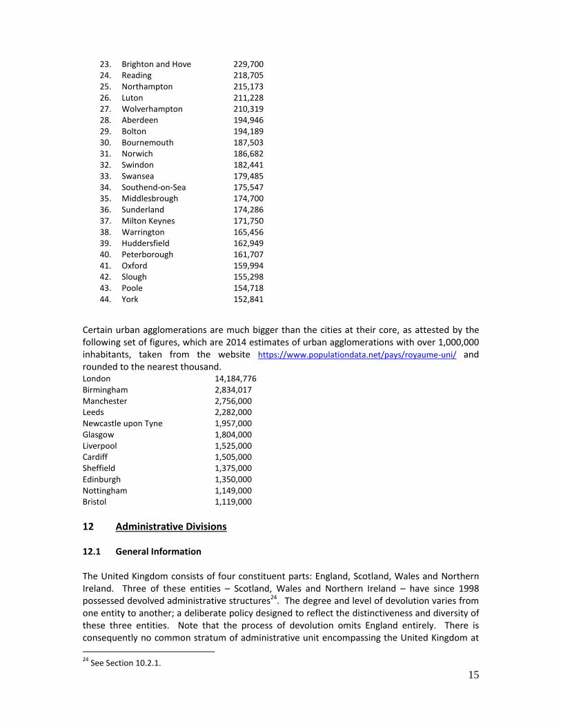
11.2 Cities and Towns The following list shows the populations of all cities and towns with 150,000 inhabitants or more. The figures are taken from the 2011 census. Notably there are now 44 cities with a population of over 150,000 while in the previous edition of the Toponymic Guidelines, based on 2009 estimates, there were 36 such cities.
1. London 8,250,205 2. Birmingham 1,085,810 3. Glasgow 590,386 4. Liverpool 552,267 5. Bristol 535,907 6. Sheffield 518,090 7. Manchester 510,746 8. Leeds 474,632 9. Edinburgh 459,366 10. Leicester 443,760 11. Bradford 349,561 12. Cardiff 335,145 13. Belfast 328,937 14. Coventry 325,949 15. Nottingham 289,301 16. Kingston upon Hull (Hull) 284,321 17. Stoke-on-Trent 270,726 18. Newcastle upon Tyne 268,064 19. Derby 255,394 20. Southampton 253,651 21. Portsmouth 238,137 22. Plymouth 234,982
23
The source for these figures is the Office for National Statistics: see the webpage at https://www.ons.gov.uk/peoplepopulationandcommunity/populationandmigration/populationestimates .
15
23. Brighton and Hove 229,700 24. Reading 218,705 25. Northampton 215,173 26. Luton 211,228 27. Wolverhampton 210,319 28. Aberdeen 194,946 29. Bolton 194,189 30. Bournemouth 187,503 31. Norwich 186,682 32. Swindon 182,441 33. Swansea 179,485 34. Southend-on-Sea 175,547 35. Middlesbrough 174,700 36. Sunderland 174,286 37. Milton Keynes 171,750 38. Warrington 165,456 39. Huddersfield 162,949 40. Peterborough 161,707 41. Oxford 159,994 42. Slough 155,298 43. Poole 154,718 44. York 152,841
Certain urban agglomerations are much bigger than the cities at their core, as attested by the following set of figures, which are 2014 estimates of urban agglomerations with over 1,000,000 inhabitants, taken from the website https://www.populationdata.net/pays/royaume-uni/ and rounded to the nearest thousand. London 14,184,776 Birmingham 2,834,017 Manchester 2,756,000 Leeds 2,282,000 Newcastle upon Tyne 1,957,000 Glasgow 1,804,000 Liverpool 1,525,000 Cardiff 1,505,000 Sheffield 1,375,000 Edinburgh 1,350,000 Nottingham 1,149,000 Bristol 1,119,000
12 Administrative Divisions 12.1 General Information The United Kingdom consists of four constituent parts: England, Scotland, Wales and Northern Ireland. Three of these entities – Scotland, Wales and Northern Ireland – have since 1998 possessed devolved administrative structures24. The degree and level of devolution varies from one entity to another; a deliberate policy designed to reflect the distinctiveness and diversity of these three entities. Note that the process of devolution omits England entirely. There is consequently no common stratum of administrative unit encompassing the United Kingdom at
24
See Section 10.2.1.
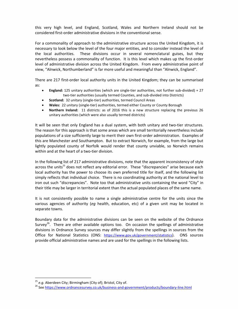
this very high level, and England, Scotland, Wales and Northern Ireland should not be considered first-order administrative divisions in the conventional sense. For a commonality of approach to the administrative structure across the United Kingdom, it is necessary to look below the level of the four major entities, and to consider instead the level of the local authorities. These divisions occur in several nomenclatural guises, but they nevertheless possess a commonality of function. It is this level which makes up the first-order level of administrative division across the United Kingdom. From every administrative point of view, “Alnwick, Northumberland” is far more useful and meaningful than “Alnwick, England”. There are 217 first-order local authority units in the United Kingdom; they can be summarised as:
England: 125 unitary authorities (which are single-tier authorities, not further sub-divided) + 27 two-tier authorities (usually termed Counties, and sub-divided into Districts)
Scotland: 32 unitary (single-tier) authorities, termed Council Areas
Wales: 22 unitary (single-tier) authorities, termed either County or County Borough
Northern Ireland: 11 districts: as of 2016 this is a new structure replacing the previous 26 unitary authorities (which were also usually termed districts)
It will be seen that only England has a dual system, with both unitary and two-tier structures. The reason for this approach is that some areas which are small territorially nevertheless include populations of a size sufficiently large to merit their own first-order administration. Examples of this are Manchester and Southampton. But to extract Norwich, for example, from the large but lightly populated county of Norfolk would render that county unviable, so Norwich remains within and at the heart of a two-tier division. In the following list of 217 administrative divisions, note that the apparent inconsistency of style across the units25 does not reflect any editorial error. These “discrepancies” arise because each local authority has the power to choose its own preferred title for itself, and the following list simply reflects that individual choice. There is no coordinating authority at the national level to iron out such “discrepancies”. Note too that administrative units containing the word “City” in their title may be larger in territorial extent than the actual populated places of the same name. It is not consistently possible to name a single administrative centre for the units since the various agencies of authority (eg health, education, etc) of a given unit may be located in separate towns. Boundary data for the administrative divisions can be seen on the website of the Ordnance Survey26. There are other available options too. On occasion the spellings of administrative divisions in Ordnance Survey sources may differ slightly from the spellings in sources from the Office for National Statistics (ONS: https://www.gov.uk/government/statistics). ONS sources provide official administrative names and are used for the spellings in the following lists.
25
e.g. Aberdeen City; Birmingham (City of); Bristol, City of. 26
See https://www.ordnancesurvey.co.uk/business-and-government/products/boundary-line.html
17
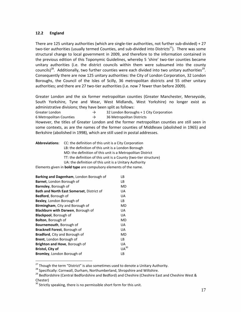
12.2 England There are 125 unitary authorities (which are single-tier authorities, not further sub-divided) + 27 two-tier authorities (usually termed Counties, and sub-divided into Districts27). There was some structural change to local government in 2009, and therefore to the information contained in the previous edition of this Toponymic Guidelines, whereby 5 ‘shire’ two-tier counties became unitary authorities (i.e. the district councils within them were subsumed into the county councils)28. Additionally, two further counties were each divided into two unitary authorities29. Consequently there are now 125 unitary authorities: the City of London Corporation, 32 London Boroughs, the Council of the Isles of Scilly, 36 metropolitan districts and 55 other unitary authorities; and there are 27 two-tier authorities (i.e. now 7 fewer than before 2009). Greater London and the six former metropolitan counties (Greater Manchester, Merseyside, South Yorkshire, Tyne and Wear, West Midlands, West Yorkshire) no longer exist as administrative divisions; they have been split as follows: Greater London → 32 London Boroughs + 1 City Corporation 6 Metropolitan Counties → 36 Metropolitan Districts
However, the titles of Greater London and the former metropolitan counties are still seen in some contexts, as are the names of the former counties of Middlesex (abolished in 1965) and Berkshire (abolished in 1998), which are still used in postal addresses. Abbreviations: CC: the definition of this unit is a City Corporation LB: the definition of this unit is a London Borough MD: the definition of this unit is a Metropolitan District TT: the definition of this unit is a County (two-tier structure) UA: the definition of this unit is a Unitary Authority Elements given in bold type are compulsory elements of the name. Barking and Dagenham, London Borough of LB Barnet, London Borough of LB Barnsley, Borough of MD Bath and North East Somerset, District of UA Bedford, Borough of UA Bexley, London Borough of LB Birmingham, City and Borough of MD Blackburn with Darwen, Borough of UA Blackpool, Borough of UA Bolton, Borough of MD Bournemouth, Borough of UA Bracknell Forest, Borough of UA Bradford, City and Borough of MD Brent, London Borough of LB Brighton and Hove, Borough of UA Bristol, City of UA
30
Bromley, London Borough of LB
27
Though the term “District” is also sometimes used to denote a Unitary Authority. 28
Specifically: Cornwall, Durham, Northumberland, Shropshire and Wiltshire. 29
Bedfordshire (Central Bedfordshire and Bedford) and Cheshire (Cheshire East and Cheshire West & Chester) 30
Strictly speaking, there is no permissible short form for this unit.

Buckinghamshire, County of TT Bury, Borough of MD Calderdale, Borough of MD Cambridgeshire, County of TT Camden, London Borough of LB Central Bedfordshire, County of
31 UA
Cheshire East, Borough of UA Cheshire West and Chester, Borough of UA Cornwall, County of UA
32
Coventry, City and Borough of MD Croydon, London Borough of LB Cumbria, County of TT Darlington, Borough of UA Derby, City of UA Derbyshire, County of TT Devon, County of TT Doncaster, Borough of MD Dorset, County of TT Dudley, Borough of MD Durham, County UA
33
Ealing, London Borough of LB East Riding of Yorkshire, District of UA East Sussex, County of TT Enfield, London Borough of LB Essex, County of TT Gateshead, Borough of MD Gloucestershire, County of TT Greenwich, London Borough of LB Hackney, London Borough of LB Halton, Borough of UA Hammersmith and Fulham, London Borough of LB Hampshire, County of TT Haringey, London Borough of LB Harrow, London Borough of LB Hartlepool, Borough of UA Havering, London Borough of LB Herefordshire, County of UA
34
Hertfordshire, County of TT Hillingdon, London Borough of LB Hounslow, London Borough of LB Isle of Wight, County of UA
35
Isles of Scilly, Council of the UA36
Islington, London Borough of LB
31
Though there is some uncertainty, it is believed that, though a Unitary Authority, this unit is termed a “County”, see: http://www.legislation.gov.uk/uksi/2008/907/note/made 32
Note that this unit, although termed a “County”, is now a Unitary Authority. 33
Note that there is no word “of” in this name, and that, although termed a “County”, it is now a Unitary Authority. 34
Note that this unit, although termed a “County”, is in fact a Unitary Authority. 35
Note that this unit, although termed a “County”, is in fact a Unitary Authority. 36
The Isles of Scilly do not formally constitute part of Cornwall but are instead separately administered by a body known as the Council of the Isles of Scilly, a sui generis unitary authority. In practice, the Isles of Scilly are often associated within Cornwall; they were not a separate unit in the 1972 Local Government Act and are included within Cornwall by the Office for National Statistics (ONS).
19
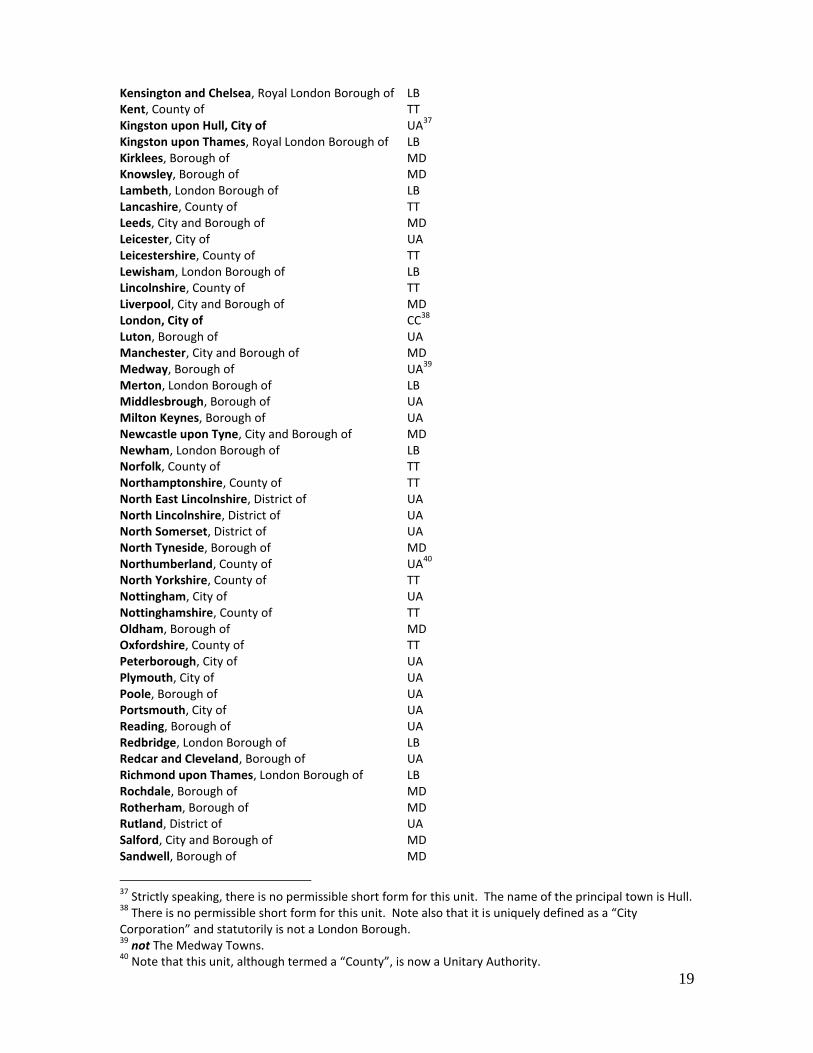
Kensington and Chelsea, Royal London Borough of LB Kent, County of TT Kingston upon Hull, City of UA
37
Kingston upon Thames, Royal London Borough of LB Kirklees, Borough of MD Knowsley, Borough of MD Lambeth, London Borough of LB Lancashire, County of TT Leeds, City and Borough of MD Leicester, City of UA Leicestershire, County of TT Lewisham, London Borough of LB Lincolnshire, County of TT Liverpool, City and Borough of MD London, City of CC
38
Luton, Borough of UA Manchester, City and Borough of MD Medway, Borough of UA
39
Merton, London Borough of LB Middlesbrough, Borough of UA Milton Keynes, Borough of UA Newcastle upon Tyne, City and Borough of MD Newham, London Borough of LB Norfolk, County of TT Northamptonshire, County of TT North East Lincolnshire, District of UA North Lincolnshire, District of UA North Somerset, District of UA North Tyneside, Borough of MD Northumberland, County of UA
40
North Yorkshire, County of TT Nottingham, City of UA Nottinghamshire, County of TT Oldham, Borough of MD Oxfordshire, County of TT Peterborough, City of UA Plymouth, City of UA Poole, Borough of UA Portsmouth, City of UA Reading, Borough of UA Redbridge, London Borough of LB Redcar and Cleveland, Borough of UA Richmond upon Thames, London Borough of LB Rochdale, Borough of MD Rotherham, Borough of MD Rutland, District of UA Salford, City and Borough of MD Sandwell, Borough of MD
37
Strictly speaking, there is no permissible short form for this unit. The name of the principal town is Hull. 38
There is no permissible short form for this unit. Note also that it is uniquely defined as a “City Corporation” and statutorily is not a London Borough. 39
not The Medway Towns. 40
Note that this unit, although termed a “County”, is now a Unitary Authority.

Sefton, Borough of MD Sheffield, City and Borough of MD Shropshire, County of UA
41
Slough, Borough of UA Solihull, Borough of MD Somerset, County of TT Southampton, City of UA Southend-on-Sea, Borough of UA South Gloucestershire, District of UA South Tyneside, Borough of MD Southwark, London Borough of LB Staffordshire, County of TT St. Helens, Borough of MD Stockport, Borough of MD Stockton-on-Tees, Borough of UA Stoke-on-Trent, City of UA Suffolk, County of TT Sunderland, City and Borough of MD Surrey, County of TT Sutton, London Borough of LB Swindon, Borough of UA
42
Tameside, Borough of MD Telford and Wrekin, District of UA
43
Thurrock, Borough of UA Torbay, Borough of UA Tower Hamlets, London Borough of LB Trafford, Borough of MD Wakefield, City and Borough of MD Walsall, Borough of MD Waltham Forest, London Borough of LB Wandsworth, London Borough of LB Warrington, Borough of UA Warwickshire, County of TT West Berkshire, District of UA
44
Westminster, City and London Borough of LB West Sussex, County of TT Wigan, Borough of MD Wiltshire, County of UA
45
Windsor and Maidenhead, Royal Borough of UA Wirral, Borough of MD Wokingham, Borough of UA Wolverhampton, Borough of MD Worcestershire, County of TT York, City of UA
41
Note that this unit, although termed a “County”, is now a Unitary Authority. 42
not Thamesdown. 43
not The Wrekin. 44
not Newbury. 45
Note that this unit, although termed a “County”, is now a Unitary Authority.

21
12.3 Scotland There are 32 unitary authorities, termed Council Areas, which are single-tier administrative structures with no sub-divisions. Strictly speaking, none of these units has any official form other than that listed below; ie the terms “City” and “City of” are a necessary part of the four names in which they occur. Aberdeen City Aberdeenshire Angus Argyll and Bute Clackmannanshire Dumfries and Galloway Dundee City East Ayrshire East Dunbartonshire East Lothian East Renfrewshire Edinburgh, City of Eilean Siar
46
Falkirk Fife Glasgow City Highland Inverclyde Midlothian Moray North Ayrshire North Lanarkshire Orkney Islands Perth and Kinross Renfrewshire Scottish Borders Shetland Islands South Ayrshire South Lanarkshire Stirling West Dunbartonshire West Lothian
12.4 Wales Wales has 22 unitary authorities; these are single-tier administrative structures with no sub-divisions. Eleven of these authorities are termed as a County; eleven are termed as a County Borough. The titles of all 22 are officially bilingual in English and Welsh; the Welsh forms are
46
Uniquely in the United Kingdom, this administrative unit has a name solely in a language (Gaelic) other than English. The English version would be Western Isles, but this is not official. Note that the Gaelic name for the geographical feature, the island grouping “Western Isles” (or more usually “Hebrides”), is Eileanan an Iar.

inset below. Note that in most cases the Welsh generic term “Sir” or “Sir y” is a necessary part of the Welsh name. Abbreviations & Terms: C: the definition of this unit is a County CB: the definition of this unit is a County Borough Bwrdeistref Sirol: = County Borough of Dinas a Sir: = City and County of Sir; Sir y: = County of Elements given in bold type are compulsory elements of the name. Blaenau Gwent, County Borough of CB Blaenau Gwent, Bwrdeistref Sirol Bridgend, County Borough of CB Pen-y-bont ar Ogwr, Bwrdeistref Sirol Caerphilly, County Borough of CB Caerffili, Bwrdeistref Sirol Cardiff, City and County of C Caerdydd, Dinas a Sir Carmarthenshire, County of C Gaerfyrddin, Sir Ceredigion, County of C
47
Ceredigion, Sir Conwy, County Borough of CB Conwy, Bwrdeistref Sirol Denbighshire, County of C Ddinbych, Sir Flintshire, County of C Fflint, Sir y Gwynedd C
48
Gwynedd Isle of Anglesey C
49
Ynys Môn, Sir Merthyr Tydfil, County Borough of CB Merthyr Tudful, Bwrdeistref Sirol Monmouthshire, County of C Fynwy, Sir Neath Port Talbot, County Borough of CB Castell-nedd Port Talbot, Bwrdeistref Sirol Newport, City of CB Casnewydd, Bwrdeistref Sirol Pembrokeshire, County of C Benfro, Sir Powys, County of C
50
Powys, Sir Rhondda Cynon Taff, County Borough of CB Rhondda Cynon Taf, Bwrdeistref Sirol Swansea, City and County of C
47
The name Ceredigion is used for the administrative unit in English and Welsh. Note that in the Welsh form use of the term “Sir” is not essential. The principal town is named Cardigan in English and Aberteifi in Welsh. 48
No generic term. 49
For the administrative unit, there is no generic term and the name is “Isle of Anglesey” in that sequence of wording. 50
Note that in the Welsh form use of the term “Sir” is not essential.

23
Abertawe, Dinas a Sir Torfaen, County Borough of CB Tor-faen, Bwrdeistref Sirol Vale of Glamorgan, The CB
51
Bro Morgannwg Wrexham, County Borough of CB Wrecsam, Bwrdeistref Sirol
12.5 Northern Ireland Until 2016 divided into 26 (single-tier) unitary authorities, termed Districts, a reform process was implemented in April 2015 resulting in a new pattern of 11 districts. The pre-1973 structure of 6 counties (Antrim, Armagh, Down, Fermanagh, Londonderry, Tyrone) is still frequently encountered but is not part of the current official administrative division structure. Elements given in bold type are compulsory elements of the name. Antrim and Newtownabbey District Ards and North Down District Armagh, Banbridge and Craigavon District Belfast City
52
Causeway Coast and Glens District Derry and Strabane District Fermanagh and Omagh District Lisburn and Castlereagh District Mid and East Antrim District Mid-Ulster District Newry, Mourne and Down District
51
No generic term. 52
Belfast remains a City: https://minutes3.belfastcity.gov.uk/mgAi.aspx?ID=187