tonga lidar factsheet - terra nova
TRANSCRIPT
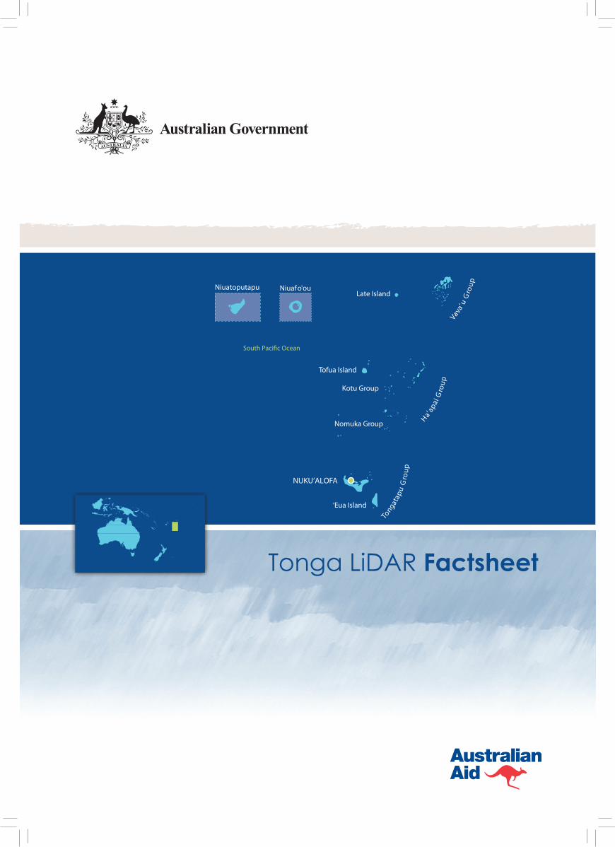
NUKU’ALOFA
Tofua Island
‘Eua Island
Kotu Group
Nomuka Group
Late Island
Vava’u
Gro
up
Ha’ap
ai G
roup
Tongat
apu
Gro
up
Niuafo'ouNiuatoputapu
Tonga LiDAR Factsheet
Tonga’s Joint National Action Plan on Climate Change Adaptation and Disaster Risk Management 2010-2015 (JNAP), the key national plan for addressing climate change adaptation in Tonga, identified managing the risk of sea level rise and coastal inundation as a priority. The north coast of Tongatapu, and the lagoons are low lying and vulnerable to sea level rise. This area includes the capital and largest city of Tonga – Nuku’alofa. Low lying villages in the Nuku’alofa areas
are affected by tidal inundation, particularly during spring tides. In addition, some families migrating from outer islands are building on reclaimed land in the tidal zone of the lagoon, exacerbating vulnerability to sea level rise.
Adaptation to future sea level rise requires a sound understanding of the potential impacts of coastal inundation. For populated coastal areas of low gradient elevation, such as Nuku’alofa and the north coast
of Tongatapu, high resolution topographic data can improve the accuracy of inundation modelling and subsequently the estimation of risk to infrastructure and communities. In addition, shallow-water bathymetric data can better inform assessments of how sea level rise may affect inundation through changing wave directions and energy. Such high resolution elevation data has not previously been available in Tonga.
PACCSAP Tonga LiDAR projectAs part of the Australian Government’s International Climate Change Adaptation Initiative (ICCAI), the Pacific Adaptation Strategies Assistance Program (PASAP) and it’s continuation the Pacific Australia Climate Change Science and Adaptation Planning (PACCSAP) Program aims to strengthen partner country capacity to assess vulnerability to climate change and develop robust adaptation strategies.
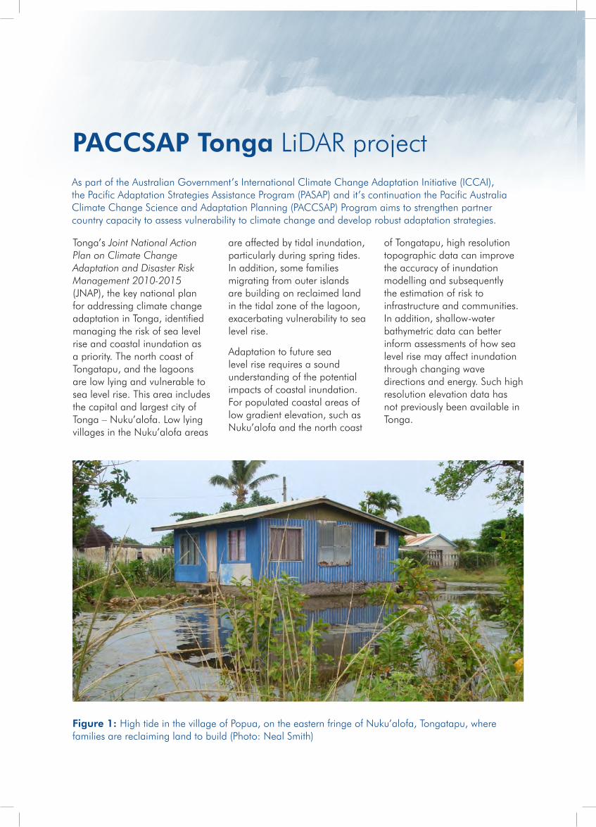
Figure 1: High tide in the village of Popua, on the eastern fringe of Nuku’alofa, Tongatapu, where families are reclaiming land to build (Photo: Neal Smith)
Discussions during 2010 between the Australian Government Department of Climate Change and Energy Efficiency (DCCEE) and Tonga’s Ministry of Environment and Climate Change (MECC) highlighted the potential for supporting Action 2.1 of the JNAP relating to the acquisition of high resolution topography and bathymetry data through Light Detection and Ranging (LiDAR) surveys, and mapping of vulnerable coastal areas of Tongatapu.
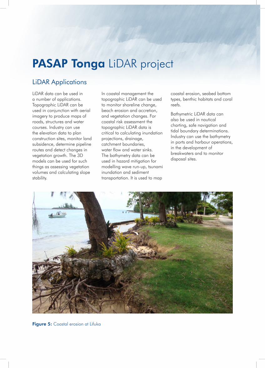
North of Tongatapu in the Ha’apai group, the island of Lifuka is particularly vulnerable to the impacts of sea level rise
following the 2006 earthquake which caused subsidence along the western shoreline of the island 23cm. Since the earthquake, the island has experienced significant coastal erosion impacting on infrastructure over a three kilometre section of the coastline. This includes the harbour, residential dwellings, a broadcasting tower, a church and the Lifuka hospital. Rising sea-levels over the next several decades and resulting wave impact, particularly at high tide, will rapidly deteriorate the existing coastline and inundate infrastructure along Lifuka’s western shoreline. Coastal erosion in Lifuka Island has
been identified at the national and community level as an adaptation priority.
For coastline management and planning it is important to have accurate data and tools for decision making. Digital elevation modelling (DEM) is an important tool for analysing the impacts of climate change on infrastructure and the environment. DEMs are produced from LiDAR surveys, therefore as a result of the 2010 JNAP discussion, DCCEE undertook topographic and bathymetric (shallow-water) LiDAR surveys of both Tongatapu and Lifuka islands.
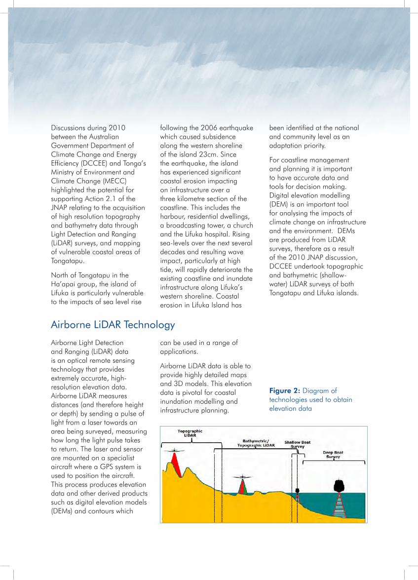
Airborne Light Detection and Ranging (LiDAR) data is an optical remote sensing technology that provides extremely accurate, high-resolution elevation data. Airborne LiDAR measures distances (and therefore height or depth) by sending a pulse of light from a laser towards an area being surveyed, measuring how long the light pulse takes to return. The laser and sensor are mounted on a specialist aircraft where a GPS system is used to position the aircraft. This process produces elevation data and other derived products such as digital elevation models (DEMs) and contours which
can be used in a range of applications.
Airborne LiDAR data is able to provide highly detailed maps and 3D models. This elevation data is pivotal for coastal inundation modelling and infrastructure planning.
Airborne LiDAR Technology
Figure 2: Diagram of technologies used to obtain elevation data
AAM Pty Ltd was engaged to capture and supply topographic data and aerial imagery for the Kingdom of Tonga, to assist future coastal planning and management. The land elevation data or heights are termed topography. A topographic LiDAR system is specifically designed to capture land heights and cannot penetrate water to obtain seafloor depths.
The topographic LiDAR for Tongatapu Island was acquired over six flights flown between 3rd October and 23rd
October 2011. The Lifuka and Foa Islands were captured during one flight on the 24th October 2011. The total area of the topographic survey for Tongatapu was 376km2. The total area for the Lifuka and Foa Islands was 28km2.
The vegetation on Tongatapu ranges from coconut plantations to dense tropical vegetation with dense undergrowth, where defining ground height can be less accurate. There are also numerous settlements scattered around the island with the capital of Tonga,
Nuku’alofa, located on the northern coastline which is low lying and faces onto a reef flat. This coastal area has bordered the seafloor survey to the north of the island. . The southern coastline is steeper, with an elevation of approximately 65m.
The island of Lifuka (in the Ha’apai Group) is situated approximately 160km north of the island of Tongatapu. This island also consists of dense tropical vegetation, and is relatively low-lying, reaching an elevation of about 5m.
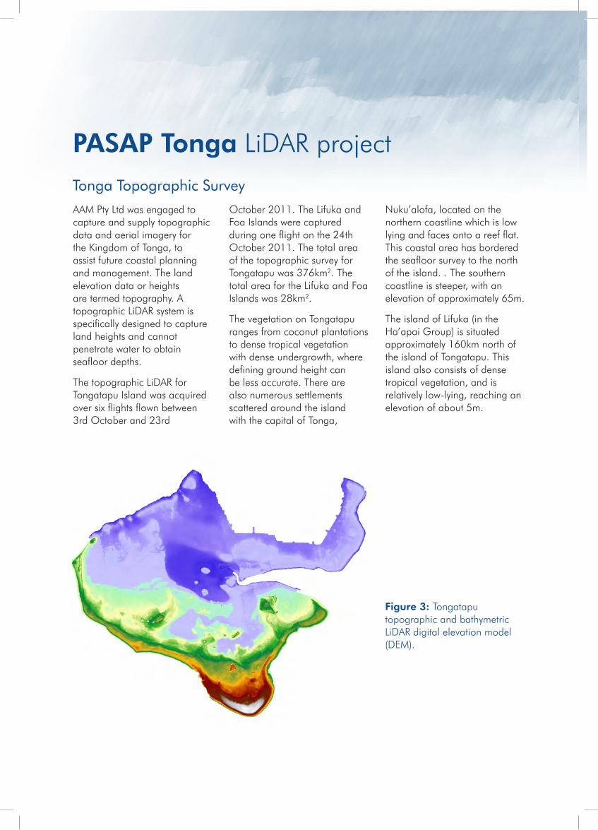
Figure 3: Tongatapu topographic and bathymetric LiDAR digital elevation model (DEM).
Tonga Topographic Survey
PASAP Tonga LiDAR project
The seafloor elevation or depths are termed bathymetry. Bathymetric LiDAR surveys work in a similar manner to topographic surveys, using slightly different lasers and sensors. For bathymetric LiDAR surveys to successfully measure the depth of water the water must be clear enough for sufficient light to reach the seafloor and return to the sensor. In addition bathymetric LiDAR surveys are effected by turbidity, depth, bottom type and obstructions. AAM Pty Ltd worked in partnership with Pelydryn Ltd to capture and supply the bathymetric data for the Kingdom of Tonga.
The bathymetric LiDAR was acquired to the north of Tongatapu Island with multiple flights flown between 5th September and 15th September 2011. The west coast of Lifuka Island was captured during one flight on 9th September 2011.
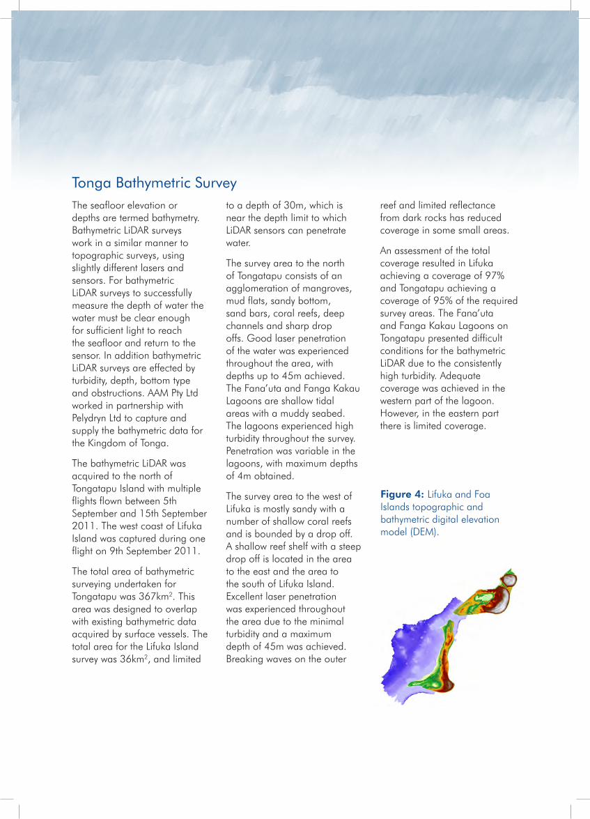
The total area of bathymetric surveying undertaken for Tongatapu was 367km2. This area was designed to overlap with existing bathymetric data acquired by surface vessels. The total area for the Lifuka Island survey was 36km2, and limited
to a depth of 30m, which is near the depth limit to which LiDAR sensors can penetrate water.
The survey area to the north of Tongatapu consists of an agglomeration of mangroves, mud flats, sandy bottom, sand bars, coral reefs, deep channels and sharp drop offs. Good laser penetration of the water was experienced throughout the area, with depths up to 45m achieved. The Fana’uta and Fanga Kakau Lagoons are shallow tidal areas with a muddy seabed. The lagoons experienced high turbidity throughout the survey. Penetration was variable in the lagoons, with maximum depths of 4m obtained.
The survey area to the west of Lifuka is mostly sandy with a number of shallow coral reefs and is bounded by a drop off. A shallow reef shelf with a steep drop off is located in the area to the east and the area to the south of Lifuka Island. Excellent laser penetration was experienced throughout the area due to the minimal turbidity and a maximum depth of 45m was achieved. Breaking waves on the outer
reef and limited reflectance from dark rocks has reduced coverage in some small areas.
An assessment of the total coverage resulted in Lifuka achieving a coverage of 97% and Tongatapu achieving a coverage of 95% of the required survey areas. The Fana’uta and Fanga Kakau Lagoons on Tongatapu presented difficult conditions for the bathymetric LiDAR due to the consistently high turbidity. Adequate coverage was achieved in the western part of the lagoon. However, in the eastern part there is limited coverage.
Figure 4: Lifuka and Foa Islands topographic and bathymetric digital elevation model (DEM).
Tonga Bathymetric Survey
LiDAR data can be used in a number of applications. Topographic LiDAR can be used in conjunction with aerial imagery to produce maps of roads, structures and water courses. Industry can use the elevation data to plan construction sites, monitor land subsidence, determine pipeline routes and detect changes in vegetation growth. The 3D models can be used for such things as assessing vegetation volumes and calculating slope stability.
In coastal management the topographic LiDAR can be used to monitor shoreline change, beach erosion and accretion, and vegetation changes. For coastal risk assessment the topographic LiDAR data is critical to calculating inundation projections, drainage, catchment boundaries, water flow and water sinks. The bathymetry data can be used in hazard mitigation for modelling wave run-up, tsunami inundation and sediment transportation. It is used to map
coastal erosion, seabed bottom types, benthic habitats and coral reefs.
Bathymetric LiDAR data can also be used in nautical charting, safe navigation and tidal boundary determinations. Industry can use the bathymetry in ports and harbour operations, in the development of breakwaters and to monitor disposal sites.
LiDAR Applications
Figure 5: Coastal erosion at Lifuka
PASAP Tonga LiDAR project
The data will be used to inform further projects between the Government of Tonga and DCCEE. The coastal modelling and capacity building project will be implemented under the Pacific-Australia Climate Change Science and Adaptation Planning (PACCSAP) program and will build on the LiDAR acquisition by:
» undertaking a capacity building and training program for relevant Government of Tonga personnel to support
management and use of the LiDAR and high resolution elevation data in a GIS environment;
» using the high resolution DEMs and other products to undertake simple coastal inundation modelling to support an initial risk assessment of priority coastal areas of Tongatapu;
» investigating and scoping potential follow-up work to support more detailed coastal modelling and risk assessment, and
» enabling the interpretation of the inundation risk assessment to support sustainable planning decisions.
The project will be coordinated by DCCEE in partnership with the Government of Tonga. Initial coastal inundation modelling and risk assessment will be integrated into the capacity building program and will be undertaken by technical personnel within the Government of Tonga with the technical assistance of a service provider.
Future work between Government of Australia and Government of TongaThe data captured through the PASAP LiDAR project is a significant asset to the Kingdom of Tonga to improve their understanding of coastal impacts from climate change and other inundation events.
Lifuka Island Assessing Vulnerability and Adaptation to Sea-Level Rise ProjectIn addition, the LiDAR data acquired under the PACCSAP LiDAR project will be made available to other projects in the region. One such project is the Pacific Adaptation Strategy Assistance Program (PASAP) project on Lifuka Island, Tonga on Assessing Vulnerability and Adaptation to Sea-Level Rise. This project, undertaken in partnership with the Ministry of Environment and Climate Change (MECC) and the Secretariat of the Pacific Community (SPC), is designed to develop an evidence-based strategy for adapting to seal-level rise and coastal erosion.
Some of the project objectives include:
» Assess the impacts of seismic subsidence of the coastal zone and people of Lifuka
» Assess the vulnerability of the coastal zone and people of Lifuka to future rises in sea-level
» Propose and assess a range of adaptation strategies for adapting to sea-level rise in Lifuka.

For further information about the Pacific-Australia Climate Change Science and Adaptation Planning program, please contact the International Adaptation Strategies team:
Canberra OfficeAdaptation, Science and Communication Division Department of Climate Change and Energy Efficiency GPO Box 854, Canberra ACT 2601, Australia
+61 2 6159 7000
Samoa OfficePACCSAP Pacific office c/- SPREP PO Box 240 Apia, Samoa
+685 66316
For information about other Australian Government Aid projects in the Pacific visit www.ausaid.gov.au (or email)
Contact us
CC
077.
0315