tonga climate resilient transport project (tcrp) ports
TRANSCRIPT

Environmental & Social
Impact Assessment
Tonga Climate Resilient
Transport Project (TCRP)
Ports Infrastructure
FINAL
August 2018
Pub
lic D
iscl
osur
e A
utho
rized
Pub
lic D
iscl
osur
e A
utho
rized
Pub
lic D
iscl
osur
e A
utho
rized
Pub
lic D
iscl
osur
e A
utho
rized

EXECUTIVE SUMMARY
The Government of Tonga is seeking funding from the World Bank for the Climate Resilient Transport
Project to facilitate the safe, efficient and sustainable movement of goods and people in the Kingdom of
Tonga, whilst strengthening climate resilience of the transport sector. The overall Project addresses
rehabilitation of key roading, maritime and airport infrastructure. The focus of this Report however, is the
proposed maritime infrastructural Project which includes minor maintenance, dredging and safety repair
works in ‘Eua (Nafanua Port), Ha’apai (Taufa’ahau Port), Vava’u (Halaevalu Port) and Niuatoputapu
(Pasivulangi Port) and channel entrances in Vava’u and Niuatoputapu.
An Environmental and Social Impact Assessment (ESIA) for the Project has been undertaken which
assesses the environmental and socio-economic impacts arising from the Project and outlines measures to
mitigate these impacts in accordance with Tongan legislation and World Bank safeguard policies.
Key stakeholders and Villages in ‘Eua, Ha’apai, Vava’u and Niuatoputapu potentially impacted by the
proposed Project were consulted and feedback has been incorporated into mitigation measures.
A number of key issues were identified that need to be resolved in the Project design phase including:
The requirement to undertake a survey to confirm location and volume of materials to be removed
at all sites and identify dredged material stockpile locations to ensure they are located in
Government land.
Undertake quantitative survey of adjacent coral reef communities and baseline water quality
surveys for monitoring purposes adjacent to all Port and channel dredging sites particularly in
relation to the ‘Utulei SMA and the oyster farms in Neiafu harbour, Vava’u.
A range of potential impacts of the Project were identified including the following:
Disturbance of undersea cable in entrance to Neiafu Harbour Vava’u
Noise disturbance generated from dredging operations at Ports in ‘Eua, Ha’apai, Vava’u.
Potential impact on movement of subsistence fishers, recreational boating and commercial shipping
due to dredging operations.
Potential impact on coastal resource users where access is restricted to Port facilities during safety
improvement works
Overall, all significant adverse impacts can be mitigated through adoption of the following measures:
Strict adherence to working hours and regular maintenance of all machinery
Confine activities to as short a period as possible
Request Port Authorities / Fisheries Authority to advise local fishers of impending works and issue
notice to all mariners.
Implementation of a grievance redress mechanism to address any local community issues that may
arise.

TCRTP – Ports Infrastructure Environmental & Social Impact Assessment ii
August 2018 Final
TABLE OF CONTENTS
1 INTRODUCTION 1
1.1 Background 1 1.2 Project Rationale 1 1.3 Project Categorisation 1
2 PROJECT DESCRIPTION 1
2.1 Background 1 2.2 ‘Eua (Nafanua Port) 2
Port Safety Improvement Works 2 Dredging Works 2
2.3 Ha’apai (Taufa’ahau Port) 3
Port Safety Improvement Works 3 Dredging Works 3
2.4 Vava’u (Halaevalu Port) 4
Port Safety Improvement Works 4 Dredging Works 5
2.5 Niuatoputapu (Pasivulangi Port) 5
Port Safety Improvement Works 5 Dredging Works 5
2.6 Nuiafo’ou (Futu Port) 6
Port Safety Improvement Works 6
2.7 Additional Port Works Methodology 6 2.8 Timing / Expected Duration of Works 7 2.9 Alternative Methodologies 7
3 ENVIRONMENTAL POLICY, LEGAL & ADMINISTRATIVE FRAMEWORK 8
3.1 Environmental Regulatory Framework 8 3.2 Environmental Approvals Framework 8 3.3 Environmental Approvals Process 10
Introduction 10 Application and Initial Evaluation Phase 10 Determination of Major or Minor Project Status 14 EIA Preparation Phase - Major Projects 14
3.4 Other Applicable Legislation 14
Aquaculture Management Act 2003 14 Bird and Fish Preservation Act 1988 15 Fisheries Management Act 2008 15 Harbours Act (1988) CAP 137 15 Marine Pollution Prevention Act 2002 15 Parks and Reserves Acts 1988 (CAP 89) 15 International and Regional Policies 16
3.5 World Bank Safeguards Policies 17
Introduction 17 Operational Policy 4.01 – Environmental Assessment 18 Operational Policy 4.04 – Natural Habitats 18
4 DESCRIPTION OF THE ENVIRONMENT 20
4.1 Introduction 20 4.2 General Environmental Description 20

TCRTP – Ports Infrastructure Environmental & Social Impact Assessment iii
August 2018 Final
4.3 Physical Environment 21
Climate 21 Climate Change 22 Coastal Hazards 23
4.4 Marine Ecology 25
Intertidal & Subtidal Ecology 25 Marine Mammals 25 Seabirds 26 Turtles 27
4.5 Social Environment 28
Demographic Data 28 Fisheries 29 Marine Traffic 30 Other Infrastructure 32 Issues associated with existing infrastructure 32
5 CONSULTATION & STAKEHOLDER ENGAGEMENT 33
5.1 Background and Approach 33 5.2 Outcome of Consultation 33 5.3 Disclosure 33
6 ASSESSMENT OF POTENTIAL IMPACTS, RISK & MITIGATION MEASURES 34
6.1 Introduction 35 6.2 Construction Impacts 35
Biophysical Impacts 35 Impact of sediment removal 35 Socio-Economic Impacts 38
6.3 Operational Impacts 39 6.4 Risk Assessment & Impact Identification Methodology 39 6.5 Outcome of Risk Assessment & Impact Identification 40 6.6 Residual Risk Matters 45 6.7 Cumulative & Induced Impacts 45
7 ENVIRONMENTAL & SOCIAL MANAGEMENT PLAN 46
7.1 Introduction 46 7.2 Performance Indicators 46 7.3 Implementation Arrangements 46 7.4 Institutional Capacity 46 7.5 Mitigation Costs 47
8 GRIEVANCE REDRESS MECHANISM 51
8.1 Grievance Redress Mechanism 51 8.2 Judiciary Level Grievance Redress Mechanism 52
9 APPENDICES 54
APPENDIX 1: TOR ERROR! BOOKMARK NOT DEFINED.
APPENDIX 2: DREDGED MATERIAL VOLUMES & LOCATIONS 55
APPENDIX 3: MARINE ECOLOGICAL RESOURCE ASSESSMENT 61
APPENDIX 4: LAND DUE DILIGENCE REPORT ERROR! BOOKMARK NOT DEFINED.

TCRTP – Ports Infrastructure Environmental & Social Impact Assessment 1
August 2018 Final
1 Introduction
1.1 Background
The Government of Tonga is seeking funding from the World Bank for the Climate Resilient
Transport Project (the Project), to facilitate the safe, efficient and sustainable movement of
goods and people in the Kingdom of Tonga, whilst strengthening climate resilience of the
transport sector.
The overall Project addresses rehabilitation of key roads, maritime and aviation sector
infrastructure. This Report focuses on maritime sector infrastructure Project which includes
minor maintenance, dredging and safety repair works in ‘Eua (Nafanua Port), Ha’apai
(Taufa’ahau Port), Vava’u (Halaevalu Port) and Niuatoputapu (Pasivulangi Port) and channel
entrances in Vava’u and Niuatoputapu.
The Ministry of Infrastructure (MOI) are the agency responsible for Project implementation.
Argo Environmental Ltd in association with Landcare Solutions Limited have been
commissioned to assess the potential environmental impacts of the Project (see TOR
Appendix 1).
1.2 Project Rationale
The Tonga Climate Resilient Transport (TCRT) Project aims to support the transport sector in
Tonga by:
Addressing the infrastructure maintenance backlog in the road, aviation and, in this
case, maritime sectors;
Increasing the resilience of transport infrastructure to climate change and extreme
weather events; and
Ensuring safer and more reliable transport services.
In accordance with the TOR for the TCRT Project, an Environmental and Social Impact
Assessment (ESIA) protocol has been adopted and an Environmental & Social Management
Plan (ESMP) has been prepared to facilitate the various transport Projects proposed.
1.3 Project Categorisation
The World Bank requires the categorisation of Project under OP 4.01. Based on Project
activities, the Project is considered to be Category B on the basis that the impacts will not be
irreversible or unprecedented, and mitigation measures can be readily identified. The
applicable safeguards policies which are triggered by the Project are OP 4.01 Environmental
Assessment and OP 4.04 Natural Habitats.
OP4.12 Involuntary Resettlement is not triggered. There will be no land acquisition required
for any project works. If any additional land is required, it will be subject to a negotiated lease
arrangement with the land owner.
2 Project Description
2.1 Background
The key proposed maritime activities include minor maintenance, dredging and safety repair
works at the following ports:
‘Eua (Nafanua Port)
Ha’apai (Taufa’ahau Port).
Vava’u (Halaevalu Port)
Niuatoputapu (Pasivulangi Port)

TCRTP – Ports Infrastructure Environmental & Social Impact Assessment 2
August 2018 Final
Safety improvement works include repairs to include activities such as sheet pile walls,
breakwaters, pavements and concrete capping beams, as well as replacement of fenders and
bollards.
Table 2A in Appendix 2 presents the volumes of dredged material for each Port identified by
MOI. Figures 2A-2D in Appendix 2 presents excerpts from the marine charts showing
proposed dredging locations supplied by MOI. Hydrographic surveys have not been
completed and the dredging volume estimates provided by MOI are based on an evaluation
of marine chart. This issue is addressed further by way of assessment of potential impacts
and mitigation measures (Section 6).
Set out below is further detail relating to the proposed scope of works for each Port.
2.2 ‘Eua (Nafanua Port)
Port Safety Improvement Works
A series of immediate and future safety improvement works for Nafanua have been
recommended1. In summary, key immediate works include:
Installation of moveable traffic barriers.
Investigate condition of tie-rods and anchor walls to determine whether the sheet pile
wall can be repaired.
Repairs to sheet pile wall on western face including a new concrete capping beam, and
installation of Fenders and bollards and a new ladder on the western berth.
The total cost of the works is estimated to be USD$832,000.
Dredging Works
The Marine and Ports Department of MOI propose the following scope of maintenance
dredging at Nafanua Port in ‘Eua:
Extraction of between 4,000 m3 (at a dredging depth of up to 2m depth) and 16,512 m3
(2-5m depth) of spoil material.
The material to be dredged is located on the eastern side of Nafanua Harbour (see
Figure 2.1) adjacent to the boat ramp and discharge from the adjacent stream.
For dredging located within the wharf basin an excavator located on the wharf is to be
used. For harbour channel excavation the excavator is to be located on a barge.
Expected total duration of works including mobilization and dredging is expected to be
15 days approximately including 5 days of dredging works.
1Cooper D., 2017. Assessment of Maritime Safety Conditions of Ports and Wharves. MOI/AF-MPD/IC-B02.

TCRTP – Ports Infrastructure Environmental & Social Impact Assessment 3
August 2018 Final
Figure 2.1: Approximate location of proposed dredging works at Nafanua Port, ‘Eua
2.3 Ha’apai (Taufa’ahau Port)
Port Safety Improvement Works
A series of immediate and future safety improvement works for Taufa’ahau Port have been
recommended1. In summary, immediate works include:
Repairs to concrete capping beam.
Filling of void under concrete ramp.
In-situ painting of existing bollards.
Replacement of damaged fenders and repairs to ladders and repairs and installation of
cap plates on piles on Naval Wharf
Repair to erosion and extension of rock revetment at outer end of Pier Ramp and
existing pavement.
Repairs to toilets in the passenger area and provision of additional seating.
The total cost of the works is estimated to be USD$535,000.
Dredging Works
The Marine and Ports Department of MOI propose the following scope of maintenance
dredging at Taufa’ahua Port in Ha’apai:
The areas of proposed dredging are located adjacent to the wharf inside the habour
and an area of shallows outside the Harbour (see Figure 2.3).
Extraction of between 2,520 m3 (to 2m depth) and 65,700 m3 (to obtain between 2
and 5m depth) of spoil material. The rationale provided for the different volumes is
that in order to accommodate deep draft vessels two areas in the entrance to the
Harbour must be dredged to a depth of 5m so that the area adjacent to the wharf
within the harbour can be dredged to a similar depth.
Expected total duration of works including mobilization and dredging is expected to
be 25 days approximately including 10 days of dredging works.
If the additional berthage option is pursued as part of future works (see Figure 2.2), an area
to the north of the existing wharf would require dredging and the material could be disposed
in the new reclamation.
200m

TCRTP – Ports Infrastructure Environmental & Social Impact Assessment 4
August 2018 Final
Figure 2.2: Location of recommended additional berthage area and reclamation (from
Cooper 20171).
Figure 2.3: Approximate location of proposed dredging works at Taufa’ahau, Ha’apai
2.4 Vava’u (Halaevalu Port)
Port Safety Improvement Works
A range of immediate and future safety improvement works for Halaevalu Port have been
recommended1. In summary, key immediate works include:
Repairs to concrete capping beam and existing pavements;
Fill and paint existing bollards and install a new bollard; replace fenders at the
international and ferry wharves; and install a new ladder on the International wharf.
The total cost of the works is estimated to be USD$533,000.
200m

TCRTP – Ports Infrastructure Environmental & Social Impact Assessment 5
August 2018 Final
Dredging Works
The Marine and Ports Department of MOI propose the following scope of maintenance
dredging at Halaevalu Port in Vava’u:
Extraction of between 9,600-68,950m3 of spoil material from adjacent to the domestic
ferry wharf and Galloway Rock located to the West (see Figure 2.4). The rationale
provided for the different volumes is that there will be a need to accommodate
progressively larger vessels with a deeper draft.
Expected total duration of works including mobilization and dredging is expected to be
25 days approximately including 10 days of dredging works.
Figure 2.4: Approximate location of proposed dredging works at Neiafu Port, Vava’u
2.5 Niuatoputapu (Pasivulangi Port)
Port Safety Improvement Works
A range of immediate and future safety improvement works for Pasivulangi Port have been
recommended1. In summary, key immediate works include:
Fill void at south-eastern corner of wharf;
Replace existing bollards and install new fenders;
Repair passenger shed and install light poles on wharf and causeway.
The total costs of the works are estimated to be USD$160,000.
Dredging Works
The Marine and Ports Department of MOI propose the following scope of maintenance
dredging works at Pasivulangi in Niuatoputapu:
Extraction of between 4,000-16,000m3 of spoil material in the channel entrance (see
Figure 2.5).
Once equipment has been secured it is likely that works will commence late 2018.
Expected total duration of works including mobilization and dredging is expected to be
40 days approximately including 10 days of dredging works.

TCRTP – Ports Infrastructure Environmental & Social Impact Assessment 6
August 2018 Final
Figure 2.5: Approximate location of proposed dredging works in the channel entrance to access Pasivulangi Port, Niuatoputapu
2.6 Nuiafo’ou (Futu Port)
Port Safety Improvement Works
A range of immediate and future safety improvement works for Pasivulangi Port have been
recommended1. In summary, key immediate works include:
Undertake repairs to the wharf embankment; and
In-situ painting of existing bollard and install new ladders.
The total cost of the works are estimated to be USD$124,000.
2.7 Additional Port Works Methodology
Dredging and Port safety improvement works methodology that is consistent across all Ports
includes:
Excavated material is to be stockpiled on land adjacent to the Wharf for reuse in areas
of the wharf requiring repair with excess material being made available for use by the
general public. The exact location is unknown at this stage but MOI have indicated it
will be on Government owned land.
MOI will either hire all the required equipment for the dredging proposed work or
purchase the equipment (except for vessel required to tow the barge and the truck
required to transport excavated material).
Small work force requirements due to the nature of the dredging works proposed with
the majority travelling with the equipment and barge from Tongatapu.
Possible need for local unskilled labour for Port safety improvement works. By
providing paid employment, even for a short duration, would assist with alleviating local
unemployment.
Any non-resident individuals required for the workforce would be housed in existing
accommodation.
200m

TCRTP – Ports Infrastructure Environmental & Social Impact Assessment 7
August 2018 Final
2.8 Timing / Expected Duration of Works
Timing and expected duration of works are unknown at this stage and are dependent on the
requirements of MOIs contract with the Contractor. The Contractor will need to take into
account seasonal issues such as cyclone season (detailed in Section 4.2.2.) particularly
with any inter-island crossings of a barge that may be required.
Normal working hours are Monday to Friday, 7am to 6pm. Works outside of these hours will
require permission from MOI and notice to affected parties and the public at least one week
prior to work commencing.
Work on a Sunday (Sabbath Day) is not permitted (as protected in the Constitution of
Tonga) and any requirements to work on a Sunday (e.g. emergency works) will require
special approvals.
2.9 Alternative Methodologies
The Ports are existing infrastructure which requires improvements to ensure continued
operation and to be more climate resilient.
The design approach and methodology for Port safety improvements are outlined in a Report
undertaken to address these issues1, and summarised in the previous Section, with a series
of recommendations made. It is considered likely that this is the most cost effective and
practical approach.
For dredging works, alternative methodologies are available (e.g., using a cutter suction
dredge based in Fiji) but the current proposed method (excavator and barge) is considered
the most cost effective and practical approach.
Overall, the preliminary designs and proposed construction methodology upon which this
impact assessment is based, have been selected on the basis that they present the most
effective use of natural resources and labour in order to minimise potential impacts on the
local environment and community.

TCRTP – Ports Infrastructure Environmental & Social Impact Assessment 8
August 2018 Final
3 Environmental Policy, Legal & Administrative Framework
3.1 Environmental Regulatory Framework
Tonga has a well-established regulatory framework that provides measures to protect and
preserve the environment from abuse, pollution and degradation, to manage the
environment for sustainable development and to promote environmental awareness.
Legislation concerning the protection and preservation of the environment is found in a
number of Acts and is the responsibility of a number of different Ministries according to their
focus. Amongst these, are the following key legislations:
Environmental Impact Assessment Act 2003 and Environmental Impact Assessment
Regulations 2010
Environmental Management Act 2010
Marine Pollution Prevention Act 2002
Parks and Reserves Act 1988
Fisheries Management Act 2002
Aquaculture Management Act 2003
Birds and Fish Preservation Act 1988
Public Health Act 1992
The Ministry of Meteorology, Energy, Information, Disaster Management, Environment,
Climate Change and Communications (MEIDECC) is the principal agency responsible for
the management of the environment, and in administering environmental-related legislation
in Tonga. It provides environmental assessments, reports and recommendations to the
responsible Ministry, as well as being mandated under the Environmental Impact
Assessment Act 2003 and the EIA Regulations 2010 to require environmental impact
assessments and impose conditions for development projects within Tonga.
Accordingly, activities funded under the TSCP will follow the GOT’s established procedures
and associated guidelines established under the Environmental Assessment Act 2003, and
environmental legislation of the relevant Ministry.
3.2 Environmental Approvals Framework
In broad terms, the environmental approval framework in Tonga involves:
Land acquisition and lease approval (Ministry of Lands and Natural Resources
“MLNR”)
Building Permit approval (Ministry of Infrastructure “MOI”)
Environmental approval (“MEIDECC”).
The application process is summarised Figure 3.1.

TCRTP – Ports Infrastructure Environmental & Social Impact Assessment 9
August 2018 Final
Figure 3.1: High level linkages between the three main environmental approval elements

TCRTP – Ports Infrastructure Environmental & Social Impact Assessment 10
August 2018 Final
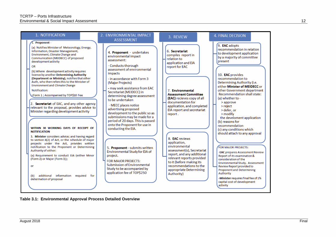
3.3 Environmental Approvals Process
Introduction
Proposals for all development activities must be notified to the Minister of Environment, Information, Disaster Management, Energy and Climate Change for approval under the Environmental Impact Assessment Act 2003 and Environmental Impact Assessment Regulations 2010.
The Secretariat and the Minister determine whether the proposed development is a “minor” or a “major” project, and this determination is to be advised to the proponent within 30 days. Proponents of major projects are required to submit a full Environmental Impact Assessment for review by the Secretariat. If the Project is deemed to be a minor project, approval is granted with or without conditions and the Project may proceed.
The broad environmental approval process is summarised in Table 3.1 and Figure 3.5.
Figure 3.4: Ministry of Infrastructure overview of approval pathway
Application and Initial Evaluation Phase
Submission of Application to EIA Unit
Proposals for all development activities when notified to MEIDECC must include a completed “Form 1” as set out in Schedule 1 of the Regulations. The Secretariat and the Minister use Form 1 to determine whether the proposed development is a “minor” or a “major” project, and they are required to advise the proponent of this determination within 30 days.
If Proponents don’t need any other permits the completed Form 1 may be delivered directly to the EIA Unit at the Environment Office of MEIDECC2. The EIA Unit will check that the correct form has been used.
However, most RE development activities would require a building permit from the Ministry
2 Vuna Rd, Nuku'alofa, Tonga

TCRTP – Ports Infrastructure Environmental & Social Impact Assessment 11
August 2018 Final
of Infrastructure (MOI) in which case the Form 1 would also be lodged with MOI,
Delivering the application to the EIA Unit involves two steps.
1. Delivering the application to the EIA Unit at the Environment Office. The EIA Unit will check that a Form 1 is attached to the building permit application.
2. Paying the $10 registration fee to the EIA Unit at the Environment Office. They will issue a receipt, and keep a photocopy of the receipt for their records. MEIDECC will not process the application until the fee has been paid.
Initial Screening Phase – MEIDECC EIA Unit
An initial screening evaluation is undertaken during consideration of the completed Form 1 provided pursuant to Schedule 1 of the EIA Regulations 2010. The main purpose of Form 1 is to help the Minister determine whether a project should be dealt with as a Minor or Major Project.
TCRTP – Ports Infrastructure Environmental & Social Impact Assessment 12
August 2018 Final
Table 3.1: Environmental Approval Process Detailed Overview

TCRTP – Ports Infrastructure Environmental & Social Impact Assessment 13
August 2018 Final
Figure 3.5: Environmental Approval Process Detailed Flowchart

TCRTP – Ports Infrastructure Environmental & Social Impact Assessment 14
August 2018 Final
Determination of Major or Minor Project Status
Once the EIA Unit has received the completed Form 1 it is assessed against the criteria in the EIA Act and EIA Regulations to determine whether the development activity is a minor or major project.
The Schedule in the EIA Act classifies a range of transport-related activities as Major Projects including:
(c) buildings, works, or land associated with the landing, take-off, parking or servicing of aircraft or helicopters;
(l) sand or gravel extraction from any beach within 50 metres of the high tide mark;
(r) construction of roads, wharfs, barrages, embankments or levees which affect the flow of tidal waters;
If the project is a Major Project, MEIDECC will issue a Form 3 and explain the next steps of the EIA process to the Proponent. If it is a minor project, the Minister will issue a Form 2.
For a major project, the proponent is required to submit a full Environmental Impact Assessment for review. The Minister subsequently issues an approval (with or without conditions), a request for further information, or a rejection.
For a minor project, approval is granted with or without conditions and the Project may proceed, usually under the provisions of an Environmental Management Plan (“EMP”) which is binding on the Proponent. The EMP will address environmental management and protection measures and will be specific to the development under consideration.
EIA Preparation Phase - Major Projects
If the Project is defined as a Major Project or if the Minister otherwise so directs based on a risk assessment, the proponent will need to conduct an EIA in accordance with Form 3 (Major Projects) of the Regulations. The purpose of the EIA is to assess potential significant environmental issues associated with a project, and to develop appropriate methods to resolve those issues.
Preparation of the EIA is the responsibility of the Project Proponent.
The EIA element of the process involves a Scoping Phase and a Preparation phase both undertaken by the proponent in collaboration with regulators and other parties as necessary. The comprehensive initial screening undertaken during preparation of the Form 1 appraisal will inform this Scoping exercise and will greatly streamline this stage of the process.
Scoping identifies existing sources of data, key individual contacts and important areas of field study. It increases local, regional and national awareness of the project, its environmental concerns and facilitates rapid data collection and analysis.
The findings of the scoping exercise (i.e. information recorded in the scoping checklist) provide a list of potential environmental issues, which should be considered and assessed in detail in the subsequent EIA.
EIA Regulation 12 sets out factors to be taken into account by the Minister and the Secretariat when considering the likely impact of an activity upon the environment, including provision of an environmental management plan.
Minor Projects – Environmental Management Plan
Minor projects are not required to provide an EIA and are approved with or without conditions.
Major Projects – Environmental Management Plan
This ESIA incorporates an Environmental and Social Management Plan (ESMP) for each
component in partial fulfilment of the requirements of the Act.
3.4 Other Applicable Legislation
Aquaculture Management Act 2003
TCRTP – Ports Infrastructure Environmental & Social Impact Assessment 15
August 2018 Final
This Act allows for the designation of areas for aquaculture management and may also declare
any associated development buffer zones.
The PIA for this Project is not proximal to any areas designation for aquaculture management.
Bird and Fish Preservation Act 1988
This Act defines species of birds and fish (including turtles) that are protected from being
killed, shot, captured, taken or destroyed within their defined protected time period. The Act
also defines protected areas within which it is prohibited to:
Discharge or cause to be discharged into the protected area any effluent or noxious or
toxic liquid or substance.
Erect any harbour, wharf, pier, jetty or other building works, temporary or permanent.
Cut, damage, remove or destroy any mangrove.
Erect any fish-fence or set any fish trap; or trawl for fish (including shellfish) or engage
in fishing for commercial purposes.
Carry out any boring, drilling or dredging operations.
The Tongatapu Lagoon is the only defined protect area within the Act which does not fall
within the PIA for this assessment. The listed protected species are not recorded as
occurring within the PIA and therefore compliance is assured.
Fisheries Management Act 2008
This Act provides for the sustainable management and extraction of fisheries resources and
governs all aspects of the fishery industry within Tonga. It recognizes the importance of
protecting marine ecosystems as a whole. This Act also governs the creation and management
of Special Managed Areas (SMAs) within the Kingdom.
Regulations for the provision of this Act include those for local fisheries, for processing and
export of fisheries resources, for the conservation of fisheries resources and the designation
of SMAs. The Project is anticipated to be in compliance with this Act.
Harbours Act (1988) CAP 137
This Act allows for the declaration of harbour areas by the Minister. This act determines:
The master of any vessel arriving near or in any harbour shall ‘bring to’ on being
approached or hailed or otherwise contacted by the harbour master and comply with
all reasonable directions issued by him as to the bringing of such vessel into harbour.
No rubbish, ballast or earth may be thrown into the harbour without the permission
of the harbour master or except at such a place and in such a manner as the harbour
master may direct.
No stones, coral, sand, earth or other material shall be removed from the beach or
from any part of any harbour as ballast or for any other purpose without the
permission of the harbour master.
Marine Pollution Prevention Act 2002
This Act provides for the prevention of and response to marine pollution and the dumping of
wastes and other matter and to give effect to international marine pollution conventions. The
Act, as a whole provides, for marine pollution prevention, marine pollution response, marine
casualties, liability and compensation for oil pollution damage and regulates dumping and
incineration of waste at sea.
This Act also lists a number of pollutants and identifies eight international conventions to which
Tonga is a party. Within the listed conventions, the following have relevance to this project and
are described later in this chapter: SPREP convention, London Convention, MARPOL, CLC,
HNS Convention, OPRC Convention, FUND and the Intervention Convention.
Parks and Reserves Acts 1988 (CAP 89)
This Act provides for the establishment of a Parks and Reserves Authority and for the

TCRTP – Ports Infrastructure Environmental & Social Impact Assessment 16
August 2018 Final
establishment, preservation and administration of parks and reserves. It enables the Parks and
Reserves Authority to seek permission to declare any area or land or sea to be a protected
area. The attached schedules to this Act define five marine reserves: Hakaumama’o Reef,
Pangaimotu Reef, Monuafe Island Park and Reef, Ha’atafu Beach and Malinoa Island. The
Parks and Reserves Declaration Amendment (1992) established the ‘Eua National Park on
‘Eua Island.
None of the marine reserves or parks are within the PIA (see Section 4.1 for further detail).
International and Regional Policies
Convention on Biological Diversity (CBD) (1998)
The CBD is a multilateral treaty with three goals:
Conservation of biodiversity
Sustainable use of its components, and
Fair and equitable sharing of benefits arising from genetic resources.
The convention was opened for signature at the Earth Summit in Rio de Janeiro in 1994 and
was ratified by Tonga in 1998. As part of its obligations to the CBD, Tonga has developed a
National Biodiversity Strategies and Action Plan (NBSAP) in which Tonga identifies several
actions under the CBD in respect to the protection of marine ecosystems. When considered
in relation to this project, actions include:
Reducing the impact of land-based activities by prohibiting dumping and chemical
discharges, prohibiting sand mining, conducting environmental assessments on
development and reducing erosion.
Increase the number of marine conservation areas (which is currently underway in
Vava’u, but in an area not associated with this project).
Promoting sustainable management of marine ecosystem.
Convention on the Conservation of Migratory Species of Wild Animals (CMS)
The CMS aims to conserve terrestrial, marine and avian migratory species throughout their
range. It is an intergovernmental treaty under the United Nations Environment Program
concerned with conservation of wildlife and habitats on a global scale.
Tonga is not yet a party to the CMS, however it has signed a Memorandum of Understanding
(2010) with regard to Pacific Island Cetaceans. Within Tongan waters there are 14 species
that are related to the CMS, including the humpback whales, and several shark and turtle
species.
Convention for the Protection of the World Cultural and Natural Heritage (2004)
This convention founded the UNESCO World Heritage Site List (the List). To be a site on this
List, it must be a place of special cultural or physical significance. The programme catalogues
names and conserves sites of outstanding cultural or natural importance to the common
heritage of humanity.
Tonga became a signatory to this convention in 2004. It does not have any approved sites
on the List but does have two tentative items for consideration for the List, neither of which
are in the geographic range impacted by this project.
United Nations Convention on the Law of the Sea
The convention lays down a comprehensive regime of law and order in the world’s oceans
and seas establishing rules governing all uses of the oceans and their resources. It enshrines
the notion that all problems of ocean space are closely interrelated and need to be addressed
as a whole.
The convention was responsible for setting the limits of various areas, measured from a
baseline. These areas are: Internal waters, Territorial waters (12nm), Archipelagic waters,
Contiguous zone (24nm), EEZ (200nm) and the continental shelf.

TCRTP – Ports Infrastructure Environmental & Social Impact Assessment 17
August 2018 Final
With specific regard to the protection and preservation of the marine environment, Part XII
includes the following Articles:
192: a general obligation of States to protect and preserve the marine environment
194: measures to prevent, reduce and control pollution
199: an obligation of States to develop and promote contingency plans for responding
to pollution incidents in the marine environment
204: requires States to endeavour, as far as possible to monitor the effects of any
activities that they permit in order to determine whether these activities are likely to
pollute the marine environment
206: provides for States to conduct Environmental Impact Assessments of planned
activities that have the potential to cause substantial pollution or significant and harmful
changes to the marine environment
The following conventions all find their force of law in Tonga through the Marine Pollution
Prevention Act 2004:
The Convention for the Protection of Natural Resources and Environment of the South
Pacific (SPREP or Noumea Convention) (1990). This convention, along with its two
protocols, entered into force in 1990. The convention is a comprehensive umbrella
agreement for the protection, management and development of the marine and coastal
environment of the South Pacific Region. As a signatory of the SPREP convention,
Tonga has agreed to take all appropriate measures in conforming to international law
to prevent, reduce and control pollution in the Convention Area from any source, and
to ensure sound environmental management and development of natural resources.
Convention on the Prevention of Marine Pollution by dumping of Wastes and Other
Matter (London Convention). The London Convention is an agreement to control
pollution of the sea by dumping and to encourage regional agreements supplementary
to the Convention. It covers deliberate disposal at sea of wastes or other matter from
vessels. Following an update of the London Convention protocols in 1996, the
convention adopted a restrictive precautionary approach to dumped materials and
permits are required to dump only those materials that are listed on the reserve list. All
other materials are to be disposed of on land.
International Convention for the Prevention of Pollution from Ships (MARPOL) 1972.
This convention is the main international convention covering prevention of pollution
in the marine environment by ships, from operational or accidental causes. It is a
combination of two treaties adopted in 1973 and 1978 and updated by amendments
throughout the years.
International Convention on Civil Liability for Oil Pollution Damage (CLC) 1992. This
convention ensures that adequate, prompt and effective compensation is available to
persons who suffer damage caused by oil spills.
The Convention on Oil Pollution Preparedness, Response and Co-Operation (OPRC)
1990. This convention is an international maritime convention establishing measures
for dealing with marine oil pollution incidents nationally and in co-operation with other
countries.
3.5 World Bank Safeguards Policies
Introduction
This ESIA is based on the following World Bank [“WB”] Operational Policies [“OPs”]3. The
3https://policies.worldbank.org/sites/ppf3/Pages/Manuals/Operational%20Manual.aspx

TCRTP – Ports Infrastructure Environmental & Social Impact Assessment 18
August 2018 Final
WB Environmental and Social Framework 20174 has not been applied as it is not yet in force.
Environmental and Social Policies
OP 4.01 Environmental Assessment
OP 4.04 Natural Habitats
OP 4.10 Indigenous Peoples does not apply to this Project – indigenous peoples are broadly
defined as “distinct, vulnerable, social and cultural group attached to geographically distinct
habitats or historical territories, with separate culture than the project area, and usually
different language”. This definition does not apply to the Tongan situation.
OP 4.11 Physical Cultural Resources (PCR)* does not apply as the Project involves works
to existing infrastructure
OP4.12 Involuntary Resettlement does not apply.
The relevant WB Policies OP 4.01 and OP 4.04. These policies are addressed further below.
Operational Policy 4.01 – Environmental Assessment
The WB requires an Environmental Assessment (EA) of Projects proposed for WB financing
to ensure they are environmentally sound and sustainable, thereby improving decision-
making.
OP 4.01 classifies the proposed project into one of four categories, depending on the type,
location, sensitivity, and scale of the project and the nature and magnitude of its potential
environmental impacts:
Category Status
A Likely to have significant adverse environmental impacts that are sensitive,
diverse, or unprecedented.
B Potential adverse environmental impacts on human populations or
environmentally important areas--including wetlands, forests, grasslands,
and other natural habitats--are less adverse than those of Category A
projects.
C Likely to have minimal or no adverse environmental impacts. Beyond
screening, no further EA action is required for a Category C project.
FI Involves investment of Bank funds through a financial intermediary, in
subprojects that may result in adverse environmental impacts.
The Project, assessed as a Category B Project, with this ESIA presenting information on the
following matters identified in OP 4.01:
• measures to prevent, minimise, mitigate or compensate adverse impacts (Section 6),
• public consultation and disclosure as part of the EA process (Section 5) and
• an Environmental and Social Management Plan (ESMP) (Section 7).
Operational Policy 4.04 – /
OP 4.04 Natural Habitats requires the conservation of natural habitats and specifically prohibits
the support of projects that involve significant conversion or degradation of critical habitats, as
defined by the policy. No such significant habitat effects are identified in relation to the Project,
but there remains the possibility of low to medium level adverse impacts on the marine
environment and therefore consideration is given to the requirements of OP 4.04.
The policy requires the EA to identify impacts on biodiversity and species; to determine project
4http://documents.worldbank.org/curated/en/383011492423734099/pdf/114278-WP-REVISED-PUBLIC-Environmental-and-Social-Framework.pdf

TCRTP – Ports Infrastructure Environmental & Social Impact Assessment 19
August 2018 Final
impacts on these species; and to propose acceptable mitigation and monitoring measures.
These matters are addressed in Section 6.2 of this ESIA.

TCRTP – Ports Infrastructure Environmental & Social Impact Assessment 20
August 2018 Final
4 Description of the Environment
4.1 Introduction
This section provides information on the physical, biological and socio-economic elements of
the environment, which forms the baseline dataset that can be used as benchmarks for any
potential future monitoring requirements. Where site-specific information is available, this
has been presented, otherwise Tonga-wide data has been referred too.
The area considered for assessment of baseline conditions (the “Project Influence area” or
“PIA”) consists of the marine environment in and immediately adjacent to the proposed
dredging works.
The PIA is defined through consideration of the project footprint including all ancillary project
components and potential impacts on environmental, economic and social resources.
Table 4.1 outlines the guidelines that have been followed to determine the PIA for the Project
which is based around a precautionary approach. All data was obtained by desktop study
and a field survey conducted in May and June 2018.
Table 4.1: Project influence areas delineations and conditions
Environment PIA
Important Species Habitat Coastal reef/mangroves areas in close proximity to
dredging areas
Inshore & Coastal Waters (<1nm from coastline)
Assuming a precautionary approach, a 250m corridor
either side of the dredging areas has been adopted
4.2 General Environmental Description
Tonga is an archipelago located directly south of Samoa and about two-thirds of the way
from Hawaii to New Zealand. Consisting of 169 islands, 36 of them inhabited, Tonga is
divided into three main groups Tongatapu, Vava’u and Ha’apai which lie approximately 800
km north to south (see Figure 4.1).
Figure 4.1: Location of Tonga and island groups in the Kingdom of Tonga.
Geologically the Tongan islands are of two types: most have a limestone base formed from

TCRTP – Ports Infrastructure Environmental & Social Impact Assessment 21
August 2018 Final
uplifted coral formations; others consist of limestone overlaying a volcanic base.
4.3 Physical Environment
Climate
The climate is tropical with a distinct warm period (December–April), during which the
temperatures rise above 32°C and a cooler period (May–November), with temperatures
rarely rising above 27 C. Between Tongatapu in the south and the more northerly islands
closer to the Equator, temperatures increase from 23 to 27 C and the annual rainfall from
1,700 to 2,970 millimetres. The average wettest period is around March with on average 263
mm. Average daily humidity is 80%.
Cyclones
Cyclone season is from November to April. In the 25 year period between 1989 and 2014,
19 cyclones tracked through the Tonga group of islands with 13 of those making landfall: 10
in Ha’apai, two in Vava’u and one in Tongatapu. Typically, the paths of cyclones are from the
northwest, moving in a south-easterly direction (Figure 4.2).
Figure 4.2: Category 3 and higher cyclone activity in Tonga 1945 – 20085
Tides
The astronomical tide is a mixed, dominant semi-diurnal type with high water levels
alternately higher and lower than the average (high water level). Mean spring tide range is
around 1.1 m, maximum spring tide range approximately 1.5 m, and mean neap range around
0.6 m.
Tide ranges and high tide levels vary over different timeframes (e.g. daily, two weekly Spring-
Neap tide, 7 month perigean-spring cycle). Longer-term cycles also influence tide range and
magnitude of the highest tide. Of particular relevance is the 8.85 year complete cycle of the
lunar perigee which influences high tides on a 4.4 year cycle.
Tide levels (and hence the level of the sea observed at any one time) can be also be elevated
5World Bank 2008. Pacific Catastrophe Risk Financing Initiative, Country Risk Profile: Tonga . Boston, MA: Air Worldwide on behalf of World Bank, SOPAC and GFDRR.

TCRTP – Ports Infrastructure Environmental & Social Impact Assessment 22
August 2018 Final
(or lowered) by other factors, the most significant in the Pacific is the ENSO cycle: During El
Niño phases sea levels are pushed down (resulting in lower high tide levels), and conversely
during La Niña phases sea levels are pushed up (resulting in higher high tide levels).
However, the influence of ENSO on mean sea level variability is not as pronounced as in the
Pacific Islands further west with variability in mean sea levels tending to be less than 0.15 m.
Climate Change
The IPCC Fifth Assessment Report6 provides broad scale climate change projections for the
Pacific region. A more detailed assessment of past and potential future climate change was
carried out for the region7. The key points are as follows:
Surface air temperature and sea surface temperature are projected to continue to
increase (very high confidence). Annual mean surface temperatures are expected to
be between 0.5° to 1°C higher by 2030 relative to 1990 and by 1°C to 2°C depending
on emission scenario by 2055.
The intensity and frequency of days of extreme heat are projected to increase (very
high confidence).
Annual and seasonal mean rainfall is projected to increase (high confidence).
Increases in annual mean rainfall are projected to be most prominent near the SPCZ,
with widespread increases in the number of heavy rain days (20-50 mm).
A number of projections however, suggest that islands located near the eastern edge of the
SPCZ, such as Tonga, may become drier in the wet season as the trade winds in the south-
east Pacific become stronger. There is also some suggestion of a shift towards the equator
of the SPCZ in the dry season (May to October), which could increase mean rainfall during
these months. In addition:
The intensity and frequency of days of extreme rainfall are projected to increase (high confidence), for example rainfall events that occur on average once every 20 years are generally simulated to occur four times per year by 2055 (high emission scenario).
Tropical cyclone numbers are projected to decline in the south Pacific sub-basin but with an increase in the proportion of more intense storms by the late 21st century. The occurrence of tropical cyclones affecting Niue will still be closely linked to the occurrence of periods of El Niño which will have a much more dominant influence on the cyclone occurrence than potential gradual changes in long-term average cyclone activity due to climate change.
Sea-level Rise
The rate of rise of sea levels across the globe is far from uniform. In some places, notably
the western Pacific, sea levels have been rising rapidly (> 10 mm a year in some places), in
others it has fallen. Since 1993 these regional differences have been measured by satellite
(Figure 4.8). Tonga is on the edge of the area in the western Pacific that has experienced
large rates of sea-level rise over the period of satellite recording period.
Over the longer term it is expected that sea-level rise over this last century around Tonga will
have been close to the global average of about 0.19 m between 1901 and 2010.
Sea levels will continue to rise primarily because of thermal expansion within the oceans and
loss of ice sheets and glaciers on land. Even if greenhouse gas emissions were stabilised
today, sea levels would continue to rise. Sea levels to about 2050 are relatively insensitive
to changes in emissions over this timeframe because of the time it takes the oceans to
respond to changes in carbon dioxide and atmospheric temperatures, but future changes
and trends in emissions become increasingly important in determining the magnitude of sea
level rise beyond 2050.
6 IPCC, 2013. Climate Change 2013: The Physical Science Basis. Contribution of Working Group I to the Fifth Assessment Report of the Intergovernmental Panel on Climate Change [Stocker, T.F., D. Qin, G.-K. Plattner, M. Tignor, S.K. Allen, J. Boschung, A. Nauels, Y. Xia, Bex and P.M. Midgley (eds.)]. Cambridge University Press, Cambridge, United Kingdom and New York, NY, USA, 1535 pp. 7 Australian Bureau of Meteorology & CSIRO, 2011. Climate change in the Pacific. Scientific assessment and new research. Volume 1: Regional overview.

TCRTP – Ports Infrastructure Environmental & Social Impact Assessment 23
August 2018 Final
The rate of global mean sea level rise during the 21st century is expected to exceed the rate
observed during 1971–2010 due to increased ocean warming and loss of mass from glaciers
and ice sheets10. For the period 2081–2100, compared to 1986–2005, global mean sea level
is likely to be between 0.26–0.54 m for the lowest emission scenario considered
(Representative Concentration Pathway scenario, RCP2.6) to between 0.45–0.81 m for the
highest emission scenario (RCP8.5) (Figure 4.9).
High tides and extreme sea levels are likely to increase close to the same rate as mean sea-
level rise in Niue. There is nothing obvious to suggest that storm surge has increased in
magnitude or frequency or will do so within the next one to two generations (30 - 50 yrs).
Long-term sea-level rise will continue to push sea levels higher resulting in high tide levels
increasingly exceeding what may be presently considered extreme or king- tide level.
Figure 4.8: Global distribution of the rate of absolute sea-level rise between January 1993 and
May2017 from satellite altimeter data. Source:
https://www.aviso.altimetry.fr/en/data/products/ocean-indicators-products/mean-sea-
level.html
Figure 4.9: Projected global mean sea-level rise to 2100 relative to the average mean sea level between 1986 to 2005 for the four future scenarios presented in the Intergovernmental Panel for Climate Change Fifth Assessment Report (IPCC, 2013).
Coastal Hazards
Tides
TCRTP – Ports Infrastructure Environmental & Social Impact Assessment 24
August 2018 Final
The astronomical tide is a mixed, dominant semi-diurnal type with high water levels
alternately higher and lower than the average (high water level). Mean spring tide range is
around 1.1 m, maximum spring tide range approximately 1.5 m, and mean neap range around
0.6 m.
Tide ranges and high tide levels vary over different timeframes (e.g. daily, two weekly Spring-
Neap tide, 7 month perigean-spring cycle). Longer-term cycles also influence tide range and
magnitude of the highest tide. Of particular relevance is the 8.85 year complete cycle of the
lunar perigee which influences high tides on a 4.4 year cycle.
Tide levels (and hence the level of the sea observed at any one time) can be also be elevated
(or lowered) by other factors, the most significant in the Pacific is the ENSO cycle: During El
Niño phases sea levels are pushed down (resulting in lower high tide levels), and conversely
during La Niña phases sea levels are pushed up (resulting in higher high tide levels).
However, the influence of ENSO on mean sea level variability is not as pronounced as in the
Pacific Islands further west with variability in mean sea levels tending to be less than 0.15 m.
Any changes in tide levels as the results of changing climate could potentially affect the Port
facilities as a result of an increase in tidal inundation.
Sea Level Rise & Erosion
The impacts of sea level rise and erosion has been investigated previously8 for Lifuka in
Ha’api. It is likely that similar issues will be experienced for the other islands.
An analysis of satellite images for the last four decades has shown that the Pangai shoreline
has receded at an average rate of 0.7 m/year, with localised rates as high as 1.4 m/year.
Erosion intensified after 1982, when a jetty in the current Port area consisting of concrete
piles and timber decking was replaced by a stone causeway and ramp. Coral heads in the
area were also blasted to provide a swing basin. The present Pangai Harbour and
breakwater were completed in 1996 which has interrupted the natural longshore sediment
drift and appears to have contributed to the erosion south of the harbour.
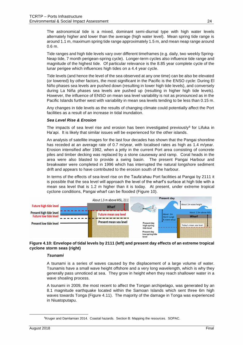
In terms of the effects of sea-level rise on the Taufa’ahau Port facilities at Pangai by 2111 it
is possible that the sea level will approach the level of the wharf’s surface at high tide with a
mean sea level that is 1.2 m higher than it is today. At present, under extreme tropical
cyclone conditions, Pangai wharf can be flooded (Figure 10).
Figure 4.10: Envelope of tidal levels by 2111 (left) and present day effects of an extreme tropical
cyclone storm seas (right)
Tsunami
A tsunami is a series of waves caused by the displacement of a large volume of water.
Tsunamis have a small wave height offshore and a very long wavelength, which is why they
generally pass unnoticed at sea. They grow in height when they reach shallower water in a
wave shoaling process.
A tsunami in 2009, the most recent to affect the Tongan archipelago, was generated by an
8.1 magnitude earthquake located within the Samoan Islands which sent three 6m high
waves towards Tonga (Figure 4.11). The majority of the damage in Tonga was experienced
in Niuatoputapu.
8Kruger and Damlamian 2014. Coastal hazards. Section B: Mapping the resources. SOPAC.

TCRTP – Ports Infrastructure Environmental & Social Impact Assessment 25
August 2018 Final
Figure 4.11: 2009 tsunami wave height and travel time9.
4.4 Marine Ecology
Intertidal & Subtidal Ecology
A qualitative assessment of the marine ecological resources adjacent to the TCRP Port sites
in Tonga has been undertaken and is provided in Appendix 3. This assessment is based on
site investigations undertaken in June 2018. In summary, the key points to note are as
follows:
Habitat in and immediately adjacent of the Ports of ‘Eua, Ha’apai, Vava’u and channel
in Niuatoputapu typically consists of: coral aggregate and sands in the deep water
directly adjacent to the wharfs; intertidal and subtidal reef flats with robust coral
communities; and the reef slope and sands of the deeper sea floor. The Port in ‘Eua
has a build-up of deposited sediment in the western part of the harbour. Galloway
Rocks in Vava’u consists of coral outcrops across the sandy bottom.
Generally, the habitat encountered is populated with a range of species that are
adapted to the less than ideal conditions (i.e., high suspended solids or wave energy)
that prevail in these locations.
Apart from the Utulei SMA in Vava’u which is located directly adjacent to the proposed
dredging location at Galloway Rocks and within the PIA, and the oyster farm in Neiafu
Harbour no areas particular significance were identified.
Water quality conditions at the time of the site visits are typically within ANZECC (2000)
default trigger values for inshore marine waters.
Marine Mammals
9 NOAA Centre for Tsunami Research.

TCRTP – Ports Infrastructure Environmental & Social Impact Assessment 26
August 2018 Final
A total of 16 species of marine mammal have been recorded within the Tongan EEZ10 (see
Table 4.1) the majority of which have been confirmed in field (or specimen) records.
The majority of research effort to date to determine the abundance and distribution of
cetaceans in Tonga has been conducted in Eu’a (located approximately 20km south east of
Tongatapu) and Vava’u (located approximately 280km north east of Tongatapu) reflecting
the fact that the larger cetaceans are migratory animals are primarily located typically
between mid-August to mid-September.
Table 4.1: Tongan cetacean species records and IUCN conservation status
Common Name Scientific Name Class Status
Minke whale Balaenoptera acutorostrata 1 LC (Pop trend: stable)
Humpback whale Megaptera novaeangliae 1 LC (Pop trend: increasing)
Melon-headed whale Peponocephala electra 1 LC (Pop trend: unknown)
Pygmy killer whale Feresa attenuata 1 LC (Pop trend: unknown)
Short-finned pilot whale Globicephala macrorhynchus 1 DD (Pop trend: unknown)
Risso’s dolphin Grampus griseus 1 LC (Pop trend: unknown)
Orca Orcinus orca 1 DD (Pop trend: unknown)
False killer whale Pseudorca crassidens 1 DD (Pop trend: unknown)
Pantropical spotted dolphin
Stenella attenuat 1 LC (Pop trend: stable)
Spinner dolphin Stenella longirostris 1 DD (Pop. trend: unknown)
Bottlenose dolphin Tursiops aduncu 1 DD (Pop trend: unknown)
Blainville’s Beaked Whale
Mesoplodon densirostris - DD (Pop trend: unknown)
Ginkgo Toothed Beaked Whale
Mesoplodon ginkgodens - DD (Pop trend: unknown)
Hector’s Beaked Whale Mesoplodon hectori - DD (Pop trend: unknown)
Fraser’s Dolphin Lagenodelphis hosei - LC (Pop trend: unknown)
Sperm whale Physeter macrocephalus 2 V (Pop trend: unknown)
Notes: LC = least concern. DD = Data Deficient. V = Vulnerable. 1 = Class 1 relatively recent field (or specimen record)
confirmation of a given species within EEZ. 2 = Class 2 potentially Class 1 record that is either dated or may be marginally
outside of a given EEZ. – = species presence reported by IUCN only.
Tongan waters are known for their yearly humpback migration11. Tongan humpbacks are
thought to represent a specific isolated breeding stock of humpback whales in the South
Pacific12. Whales migrate are known to migrate past various islands in the Tonga group.
It is considered unlikely that there will be any significant impacts on migrating whales as all
works are confined to Ports or channel entrances with migration pathways located outside
the PIA.
Seabirds
There are 15 species of seabirds with a known presence in Tonga according to the IUCN
and Birdlife International.13 A recent checklist reported as many as 41 species14, including
the wandering albatross, one giant petrel, several additional petrel and storm-petrel species,
four shearwater species, three species of skuas, and many more tern species (Table 4.2).
As many as twenty three of these species, such as black noddies, brown noddies and white
terns, may also breed in Tonga. A number of the islands in the Tongan group (such as
Maninita, ‘Ata, Late Hunga Ha’apai, and Fonualei Islands) provide nesting or breeding habitat
for these bird species.
10 SPREP 2007. Secretariat of the Pacific Regional Environment Programme Pacific Islands Regional Marine Species Programme 2008 – 2012. Apia Samoa, SPREP:48. 11 Orams, M. 2001. "From Whale Hunting to Whale Watching in Tonga: A Sustainable Future?" Journal of Sustainable Tourism 9(2): 128-146. Olavarría, C et al. 2005. Population structure of humpback whales throughout the South Pacific with reference to the origins of the eastern Polynesian breeding grounds. SC/57/For Information 8 Report to the Scientific Committee of the International Whaling Commission. Garrigue, C., C. Olavarria, et al. 2006. Demographic and genetic isolation of New Caledonia (E2) and Tonga (E3) breeding stocks. Inter-sessional Workshop for the Comprehensive Assessment of Southerm Hemisphere Humpback Whales. Hobart. 12 Olivarria et al. 2007. Population structure of South Pacific humpback whales and the origin of the eastern Polynesian breeding grounds. Mar. Ecol. Prog. Ser. 330: 257-268 13 www.birdlife.org 14 Environment Consultants Fiji 2001. Summary list of the Birds of Tonga. Pacific Birds. Suva Fiji Islands.

TCRTP – Ports Infrastructure Environmental & Social Impact Assessment 27
August 2018 Final
It is considered unlikely that there will be any significant impact on seabird nesting or breeding
habitat on the basis of the PIA.
Table 4.2: Seabird species in Tonga and their IUCN conservation status
Common Name Scientific Name Status
Herald Petrel Pterodroma heraldic LC
Wedge tailed Shearwater Puffinus pacificus LC
White-tailed Tropicbird Phaethon lepturus LC
Lesser Frigatebird Fregata ariel LC
Masked Booby Sula daactylatra LC
Red-footed Booby Sula sula LC
Brown Booby Sula leucogaster LC
Great Crested Tern Sterna bergii LC
Black-naped Tern Sterna sumatrana LC
Sooty Tern Sterna fuscata LC
Brown Noddy Anous stolidus LC
Black Noddy Anous minutus LC
Blue Noddy Procelsterna cerulea LC
Common White Tern Gygis alba LC
Phoenix Petrel Pterodroma alba EN
Notes: LC = least concern. EN = Endangered.
Turtles
Four species of sea turtle have been reported from within Tongan waters; the leatherback,
green, olive ridley and hawksbill (Table 4.3). The green and hawksbill turtle are the most
common15. There is limited information on migrations or connectivity to South Pacific
populations or on nesting beaches in Tonga. Two species (Olive Ridley Turtle Lepidochelys
olivacea and Green Turtle Chelonia mydas) are considered critically endangered reduction
in population size of 80% over the last 10 years or three generations.
Table 4.3: Sea Turtle species in Tonga and their IUCN conservation status
Common Name Scientific Name Status
Hawksbill Turtle Eretmochelys imbricata CR
Leatherback Turtle Dermochelys coriacea CR
Olive Ridley Turtle Lepidochelys olivacea EN
Green Turtle Chelonia mydas EN
Notes: CR = Critically endangered. EN = Endangered.
Marine turtles are also protected in Tongan waters under the Fisheries Management
(Conservation) Regulations 2008, although males (over 45cm carapace lengths) of certain
species are subject to open fishing seasons during February to August each year. Green turtles
and hawksbill turtles are known to nest in Vava’u (Figure 4.12) and Ha’apai although
occurrences of nesting activity is very low and distributed over scattered outer islands
(SPREP). The peak nesting season is from December to January.
Although the proposed dredging operations do not appear to conflict with any turtle nesting
locations in Vava’u, or known foraging grounds, monitoring for presence of turtles is
recommended during dredging operations.
15 Prescott, N. 2004. Tonga Biodiversity Stocktaking. Technical Report 1: For the Development of a National Biodiversity Strategic Action Plan. Tonga Department of Environment. Tongatapu, Tonga. 275.

TCRTP – Ports Infrastructure Environmental & Social Impact Assessment 28
August 2018 Final
Figure 4.12: Marine turtle nesting map for Vava’u14
4.5 Social Environment
Demographic Data
Population
Population data is provided in the 2016 census16. The following key points can be made:
the Kingdom of Tonga has a total population of 100,651 (50,312 males and 50,433
females) compared with 103,252 in 2011.
The largest Island, Tongatapu, has 74% of the population (74,611) and with a land
area of 257 km2, this equates to a population density of 290.6 persons per km2.
Vava’u, Ha’apai, ‘Eua and Niuatoputapu have populations of 13,740, 6,144, 4,950 and
1,232 respectively and with land areas of 138, 109.3 87.4 and 71.7 km2 respectively,
equating to population densities of 99.5, 56.2 56.6 and 17.2 persons respectively per
km2.
16Tonga 2016. Census of population and housing. Volume 1: basic tables and administration Report. Tonga Statistics Department.
TCRTP – Ports Infrastructure Environmental & Social Impact Assessment 29
August 2018 Final
Since the 2011 census there has been an overall population decline in Tonga of 2.5% with
islands ranging from 1.1 % (Tongatapu) to 7.9% (Vava’u). The issues associated with
population decline in outer islands are likely to be many and varied but it is possible that the
ongoing investment in infrastructural Projects such as the Port upgrade and dredging projects
may in a small part assist with retaining population in these locations.
Employment
The key points relating to economic activity in the Islands identified in the 2016 census14 are
as follows:
In Vava’u, 5,715 (41.5%) of the total population of 13,738 are economically active with
1,850 (13.5%) subsistence workers. 14% of the population are unemployed.
In Ha’apai, 2,828 (46%) of the total population of 6,125 are economically active with
918 (15%) subsistence workers. 9.7% of the population are unemployed.
In ‘Eua, 2,143 (43.4%) of the total population of 4,945 are economically active with 717
(14.4%) subsistence workers. 12.4% of the population are unemployed.
In Niuatoputapu, 588 (47.7%) of the total population of 1,232 are economically active
with 107 (9%) subsistence workers. 5% of the population are unemployed.
Possible short-term employment opportunities associated with the Project will assist with
providing paid employment to local villagers in the islands.
Fisheries
Commercial and subsistence fishing
Both commercial and subsistence fishing is undertaken in Tonga. The commercial fishery
targets tuna, snapper, commercial sport, seaweed and the aquarium trade17. Subsistence
fisheries common throughout the Tonga target mostly reef fish by a variety of methods such
as night spearfishing, gillnetting, hand-line fishing and the use of fish fences18. Small boats
of various types are used including canoes, outboard-powered dinghies and inboard-motor
vessels.
According to the FAO, Tonga’s fisheries and their proportional associated production are
estimated as: Coastal Commercial 54%; Coastal Subsistence 30%; Offshore: Locally Based
15%; Offshore: Foreign Based 0%; and Freshwater & Aquaculture <1%.
In the past mullet, beche-de-mer (sea cucumber), lobster and giant clam have had
commercial value but severe population declines has resulted in these species being mostly
absent from both commercial and subsistence fishing. Fishery exports are dominated by
tuna and deep-water snappers (red snapper (Etelis coruscans) and pink snapper
(Pristopomoides filamentosus)) which are air-freighted fresh mainly to Hawaii19.
The inshore fishery is dominated by four main methods: diving/spear fishing, gill netting,
bottom fishing and reef gleaning. Spear fishing targets reef fish while the 19 registered bottom
fishing vessels in Tonga target deep water snappers, groupers, trevallies, jacks and jobfish.
Reef gleaning is traditionally undertaken by the women of the community and surveyed coastal
households showed that most women carried out some form of gleaning20.
17 CFC 2007. Tonga Commercial Fisheries Conference. Tongatapu, Tonga. 18 Malm, T. 2001 The tragedy of hte commoners: the decline of the customary marine tenure system of Tonga. SPC Traditional Marine Resource Management and Knowledge Information Bulletin 13: 3-13. Kronen, M. 2004. Fishing for fortunes? A socio-economic assessment of Tonga's artisanal fisheries. Fisheries Research 70: 121-134. Gillett, R. 1994. Tonga Fisheries Bibliography. FAO. Suva, Fiji Islands, FAO: 93. 19 Chapman, Lindsey. 2000. Development Options and Constraints Including Training Needs Within the Tuna Fishing Industry and Support Services in the Kingdom of Tonga. Secretariat of the Pacific Community. Noumea, New Caledonia. 53pp. Hamilton, A. & M. Batty 2007. Constraints to Tuna Fisheries Development in the Pacific. Tonga National Commercial Fisheries Conference. Tonga, FFA. 20Pacific Environmental Consulting 2016. Environmental Assessment. Tonga Cable Extension Project: Nuku’alofa, Ha’api & Vava’u. Prepared for Tonga Cable Ltd, Nuku’alofa, Tonga. April 2016.
TCRTP – Ports Infrastructure Environmental & Social Impact Assessment 30
August 2018 Final
In a recently referenced14 World Bank study, residents of six coastal communities were asked
to identify the three subsistence fishery resources most important to them. Seven types were
most commonly cited: finfish, octopus, lobster, bêche-de-mer, giant clams, seaweed and
Anadara (shellfish).
In Vava’u directly adjacent to the area proposed for dredging at Galloway Rocks there is a
local Special Marine Area (SMA) which is overseen by the local community (see Appendix 3
for further detail) to manage fisheries resources that they rely on for food and income. SMAs
are legislated under the Fisheries Management Act 2002 for the purposes of community-
based fisheries management in their adjacent coastal areas.
Aquaculture
The Ministry of Fisheries has developed an aquaculture program in Vava’u primarily focusing
on the customary significance and improvement of livelihood that this program can bring.
Currently Tonga has aquaculture programs focusing on Wing Pearl Oyster (Pteria penguin)
farming, Giant Clam (Tridacna derasa) cultivation, live rock and coral cultivation and the
cultivation of other edible species such as urchins (Tripneustes sp.) and seaweed
(‘Limufuofua’).
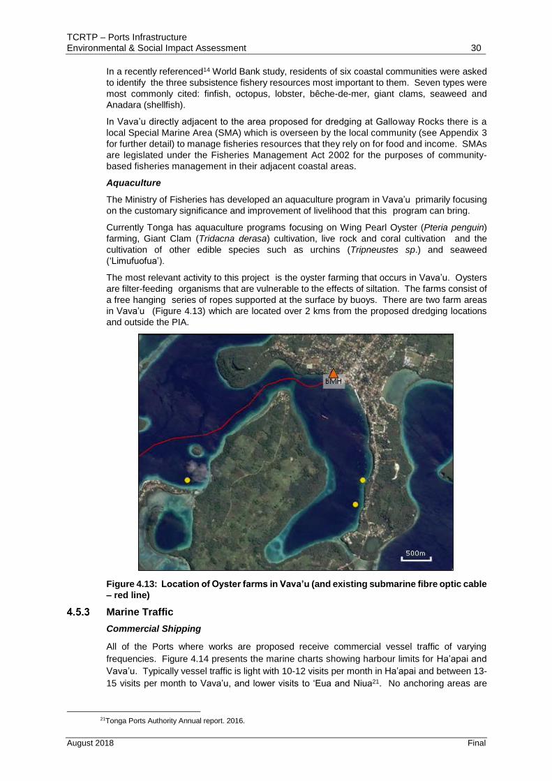
The most relevant activity to this project is the oyster farming that occurs in Vava’u. Oysters
are filter-feeding organisms that are vulnerable to the effects of siltation. The farms consist of
a free hanging series of ropes supported at the surface by buoys. There are two farm areas
in Vava’u (Figure 4.13) which are located over 2 kms from the proposed dredging locations
and outside the PIA.
Figure 4.13: Location of Oyster farms in Vava’u (and existing submarine fibre optic cable
– red line)
Marine Traffic
Commercial Shipping
All of the Ports where works are proposed receive commercial vessel traffic of varying
frequencies. Figure 4.14 presents the marine charts showing harbour limits for Ha’apai and
Vava’u. Typically vessel traffic is light with 10-12 visits per month in Ha’apai and between 13-
15 visits per month to Vava’u, and lower visits to ‘Eua and Niua21. No anchoring areas are
21Tonga Ports Authority Annual report. 2016.
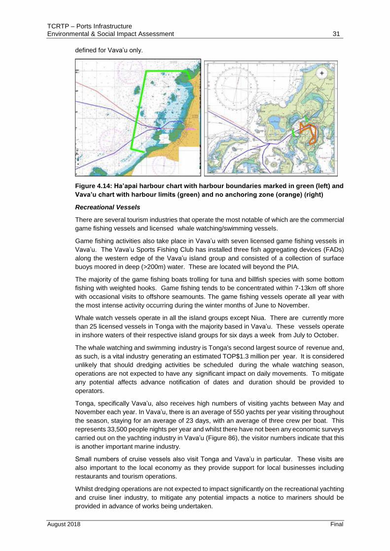
TCRTP – Ports Infrastructure Environmental & Social Impact Assessment 31
August 2018 Final
defined for Vava’u only.
Figure 4.14: Ha’apai harbour chart with harbour boundaries marked in green (left) and
Vava’u chart with harbour limits (green) and no anchoring zone (orange) (right)
Recreational Vessels
There are several tourism industries that operate the most notable of which are the commercial
game fishing vessels and licensed whale watching/swimming vessels.
Game fishing activities also take place in Vava’u with seven licensed game fishing vessels in
Vava’u. The Vava’u Sports Fishing Club has installed three fish aggregating devices (FADs)
along the western edge of the Vava’u island group and consisted of a collection of surface
buoys moored in deep (>200m) water. These are located will beyond the PIA.
The majority of the game fishing boats trolling for tuna and billfish species with some bottom
fishing with weighted hooks. Game fishing tends to be concentrated within 7-13km off shore
with occasional visits to offshore seamounts. The game fishing vessels operate all year with
the most intense activity occurring during the winter months of June to November.
Whale watch vessels operate in all the island groups except Niua. There are currently more
than 25 licensed vessels in Tonga with the majority based in Vava’u. These vessels operate
in inshore waters of their respective island groups for six days a week from July to October.
The whale watching and swimming industry is Tonga's second largest source of revenue and,
as such, is a vital industry generating an estimated TOP$1.3 million per year. It is considered
unlikely that should dredging activities be scheduled during the whale watching season,
operations are not expected to have any significant impact on daily movements. To mitigate
any potential affects advance notification of dates and duration should be provided to
operators.
Tonga, specifically Vava’u, also receives high numbers of visiting yachts between May and
November each year. In Vava’u, there is an average of 550 yachts per year visiting throughout
the season, staying for an average of 23 days, with an average of three crew per boat. This
represents 33,500 people nights per year and whilst there have not been any economic surveys
carried out on the yachting industry in Vava’u (Figure 86), the visitor numbers indicate that this
is another important marine industry.
Small numbers of cruise vessels also visit Tonga and Vava’u in particular. These visits are
also important to the local economy as they provide support for local businesses including
restaurants and tourism operations.
Whilst dredging operations are not expected to impact significantly on the recreational yachting
and cruise liner industry, to mitigate any potential impacts a notice to mariners should be
provided in advance of works being undertaken.

TCRTP – Ports Infrastructure Environmental & Social Impact Assessment 32
August 2018 Final
Other Infrastructure
A fibre optic cable installed in 2016 currently sits on the seabed along the channel approach
to Neiafu harbour, and into Neiafu Harbour itself. In addition, the same fibre optic cable
comes ashore at Pangai in Ha’apai just south of the main Port. Figure 4.11 shows the
approximate orientation of the cable in Neiafu and Figure 4.15 in Pangai, Ha’apai.
As built drawings will be required to establish where the cable is located particularly in Neiafu
prior to dredging works being undertaken.
Figure 4.15: Location of submarine fibre optic cable in Pangai, Ha’apai
A fish trap in Pangai, Ha’apai is located south of the Taufa’ahau Port and Harbour and outside
the PIA.
Issues associated with existing infrastructure
Information to allow an evaluation of the importance of functioning Port facilities (including
access to these facilities) for local island communities is limited. However, anecdotal
evidence and community consultation outcomes (see Appendix 4 for detail), although limited
in terms of specific feedback relating to the Ports Projects, indicates local communities on all
islands depend on functioning Ports for their survival for a number of reasons as follows:
Income from tourism activities from tourists arriving in larger cruise liners and
recreational yachts particularly in Vava’u (as outlined in Section 4.5).
General access for all vessels including those that undertake subsistence, commercial
and recreational fishing (see Section 4.3.5). In Niuatoputapu for example, the vessel
which ships essential supplies to the island can often be delayed due to unfavourable
weather conditions that restrict access to the Port facility through the shallow channel
entrance.
Public travel to and from Tongatapu and the other Tonga Islands. In ‘Eua for example,
ferry travel is often curtailed due to the restricted access to the Port during unfavourable
weather conditions.
Public safety. In ‘Eua for example, use of the boat ramp in the eastern part of the
harbour is restricted to high tide and relatively calm seas due to dangerous nature of
launching smaller vessels at any other tide and sea state. This in turn impacts on local
fishing industry and tourism operators.
Export of crops and fish to wider markets which provides income to islanders.
In terms of potential gender-specific impacts, reef gleaning is traditionally undertaken by the
women of the community, but it is of limited relevance given the nature and scope of the

TCRTP – Ports Infrastructure Environmental & Social Impact Assessment 33
August 2018 Final
proposed Port works.
5 Consultation & Stakeholder Engagement
5.1 Background and Approach
As required by WB Safeguard Policies consultation and disclosure of Category B projects
must be undertaken with project affected groups (stakeholders) and non-government
organisations (NGO).
The potential environmental and social impacts of the project require the opportunity for
discussion and review during the environmental assessment/ESMP process to inform
detailed design and mitigation measures.
The ESMP remains a draft until public disclosure and consultation has been completed. This
will allow for the ESMP to be updated with details of consultation and disclosure as and when
this is completed. Disclosure and consultation will be the responsibility of MOI.
5.2 Outcome of Consultation
Appendix 3 details the outcome of the public consultation process. Table 5.1 summarise the
public consultation undertaken. The key points to note are as follows:
In ‘Eua, a total of 5 public consultation meetings were held in Houma, ‘Ohonua, Mu’a,
Angaha and Kolomaile Villages.
In Vava’u, a total of 11 public consultation meetings were held in Pangaimotu,
Leimatu’a, Mataika, Tu’anekivale, Tu’anuku, Longomapu, Tefisi and Houma Villages.
A total of 136 people attended the meetings including both men (97) and women (39).
In Ha’apai, a total of 7 public consultation meetings were held with villages located
across the main Island of Lifuka including Ha’ateihosi’I, Faleloa, Faleloa, Koulo Pangai
and Vahe Foa Villages. A total of 79 people attended the meetings including both men
(46) and women (33).
In Niuatoputapu, one public consultation meeting was held with villagers at the wharf
when they were gathered for the arrival of the ferry. A total of 28 people attended the
meetings including both men (17) and women (11).
Overall, a total of over 140 people attended the public consultation meetings or were met
with to discuss the Project and garner feedback. Table 5.2 summarises the feedback
received. No specific comments were provided regarding the Ports Project in meetings held
in Vava’u Ha’apai and ‘Eua apart from indicating support with most people’s attention
focussed on the roading upgrade Project. In Niuatoputapu, a number of comments were
made regarding the proposed Port Project summarised as follows:
Villagers rely on the shipping service for supplies and sending cargo.
The Project will help to improve wharf to make sure ferry will dock anytime.
Deeper wharf may allow bigger ships to dock.
No issues relating to gender, age or vulnerable groups were raised.
5.3 Disclosure
Disclosure is about transparency and accountability through release of information about the
project and does not equate to consultation (and vice versa). This ESIA / ESMP document
will be made available on the WB Infoshop website and in hard copy at Government offices
and community centres on Tonga (most applicable and accessible).

TCRTP – Ports Infrastructure Environmental & Social Impact Assessment 34
August 2018 Final
Table 5.1: Summary of public consultation
Location Date Village/Ministry Gender
Male Female
‘Eua 19.06.18
‘Eua Governor + Town Officers 1+
Houma
‘Ohonua
Mu’a
Angaha
Kolomaile
Ha’apai 06.06.18 Ha’apai Governor & Town Officers 6 -
Weaving Women’s Group - 3
Ha’ateihosi’i 4 9
Faleloa 6 9
Koulo 9 4
Pangai 8 3
07.06.18 Vahe Foa 12 5
TAL 1
Vava’u 13.06.18 Neiafu 13 5
14.06.18 Governor 1 -
Weaving Women’s Group - 2
Pangaimotu 3 4
Leimatu’a 11 6
Mataika 16
15.06.18 Tu’anekivale (incl. Mangia) 13 7
Tu’anuku 7
Longomapu 15 4
Tefisi 7 4
16.06.18 Houma 11 7
Niuatoputapu
13.06.18 Niua Toputapu 17 11
Table 5.1: Summary of comments made during public consultation
Communities Communities Comments
Vava’u
Tefisi, Longomapu - Support wharf upgrade
Neiafu - No comment
Tu’anekivale, Mangia - Wharf dredging welcomed.
Tu’anuku, Longomapu - No comment
Pangaimotu - Concur for need for wharf dredging
Mangia, Houma, Mataika - No comment
Neiafu - No comment
Tefisi, Vaihoi, Leimatu’a - No comment
Ha’api
Koula - Wharf dredging is needed
Pangai, Holopeka, Hihifo, - No comment
Loto Foa, Fotua, Fangale’ounga
- Welcome wharf dredging
‘Eua
Mu’a, Angaha, Kolomaile* - No comment
Houma - Approve of wharf dredging
Ohonua - Wharf dredging is good
Niuatoputapu
Hihifo, Vaipoa, Falehau - Welcomed and support the proposed dredging - Rely on the shipping service for supplies and also sending cargo to
Tongatapu - Help to improve wharf to make sure ferry will dock anytime - Deeper wharf may allow bigger ships to dock, which is a bonus for the island
6 Assessment of Potential Impacts, Risk & Mitigation Measures

TCRTP – Ports Infrastructure Environmental & Social Impact Assessment 35
August 2018 Final
6.1 Introduction
The TCRT Project has the potential to create a variety of impacts. These potential impacts
are either positive or negative depending on the receptors involved. The impact of this project
on the social, ecological and physical environment has been assessed using methodology
described in this chapter.
The impact assessment process initially involves identification of the project’s activities and
potential environmental and social impacts resulting from each activity during the project
phases. A project activity could include site preparation, construction, reinstatement,
operation and maintenance.
This ESIA document defines an impact as “any change to the physical, biological or social
environment, whether adverse or beneficial, wholly or partially resulting from an
organisation’s activities, products or services”.
This section provides an assessment of the potential construction and operational impacts of
the proposed TCRT Project on the physical and ecological and socio-economic resources on
and adjacent to the site. Potential impacts have been identified and evaluated as to whether
they are adverse, positive, or have a negligible or neutral impact. These issues are discussed
in the following sections in relation to the proposed Project activities.
6.2 Construction Impacts
Biophysical Impacts
Potential biophysical impacts associated with the proposed Port safety improvements to the
wharfs are not considered significant and are not considered further.
Potential biophysical impacts arising as a result of proposed dredging activities are as
follows:
Loss or change in benthic habitat, ecology and physical characteristics
Generation of suspended solids and offsite deposition.
Changes in water quality.
Water column and sediment toxicity.
In addition, potential impacts may arise as a result of disposal of dredged material to land
such as silt runoff and salt leaching affecting adjacent marine or terrestrial environment. Due
to the lack of significant vegetation in and adjacent to the Port facilities the potential impact of
salt leaching is not expected to be significant relation to proposed dredging activities.
Impact of sediment removal
The removal of sediment by dredging at the Port facilities in ‘Eua, Ha’apai, Vava’u and the
channel areas in Vava’u and Niuatoputapu will result in the disturbance to and loss of benthic
habitat. The benthic communities of these areas are summarised in Section 4.4.1 and in
detail in Appendix 3. However, this potential impact is not expected to be significant due to
the following:
No species or ecological communities of particular ecological or social concern, or
conservation value are likely to be present in proposed dredging footprint. In this regard,
removal of existing bottom habitat is considered to be of little or no significance.
Over time, the dredged area will be recolonised by invertebrate species typical of the
area.
A. SEDIMENT RESUSPENSION
Sediment Sources

TCRTP – Ports Infrastructure Environmental & Social Impact Assessment 36
August 2018 Final
All dredging operations resuspend some sediment during the extraction process. The
mechanism by which sediment is resuspended depends on:
The dredging method – In this case the proposed method (excavator) has the advantage
in that the amount of sediment disturbance and resuspension is minimised compared
with many other dredging techniques.
The characteristics of the sediment – With the exception of ‘Eua, the sediments in the
areas to be dredged have a large sand component minimising silt resuspension.
The depth of dredging and water at the site – the maximum depths of dredging at sites
is approximately 3-5m.
Tidal currents and turbulence at the site – given the limited range tidally driven current
speed is likely to be low.
Operational considerations such as equipment type, method of operation and skill of the
operator.
Issues
Resupension and transport of sediment may result in the following impacts:
Physical effects of sedimentation on benthic communities.
Reduction in water clarity due to increases in water-borne suspended solids
concentrations.
In addition, potential impacts relating to the release of sediment-associated contaminants to
the water column and potential toxic effects of contaminants in redeposited sediment on
benthic communities can arise.
The various Port facilities were visited in June 2018 and a preliminary assessment of the risk
of potential contaminated sediments being present adjacent to these wharfs undertaken.
Given the lack of high risk activities undertaken the port facilities the risk of contaminated
sediments being present is low.
The other potential issues identified above are discussed in detail below.
Extent of Sediment Resuspension
Sediment resuspension and downstream transport have been assessed in a number of New
Zealand harbours and estuaries.
Dredging using less precise dredging methods such as clamshell dredging (similar in effect
to an excavator) of the Auckland naval base, Port of Onehunga, Half Moon Bay marina, Pine
Harbour marina22 have also not resulted in any identifiable downstream increases in
suspended solids concentrations. Typical release rates of 2,250 kg/hr (or 1.5 m3/hr) have
been measured.
Sediment Dispersion
Suspended solids generated on an ebb or flood tide could potentially travel offsite. Estimating
the cumulative dispersed increase in suspended solids depends on an accurate knowledge
of the rate of release of sediment to the water column. Based on the release rate identified
in the previous Section and the development of a typical ‘triangular’ plume, it is predicted that
22Kingett Mitchell 1995. Effects on the marine environment associated with the expansion of the Fergusson container terminal. Prepared for BCHF Ltd. November 1995.

TCRTP – Ports Infrastructure Environmental & Social Impact Assessment 37
August 2018 Final
the release of 2,250 kg of sediment per hour from the dredging operation would result in a
downstream net addition of suspended solids of 25 - 42 g/m3 based upon:
Concentration = mass release / width x depth x tidal velocity
Where: 0.15 m s-1 = mean tidal velocity
50m = plume width at 200m from the dredged area
3-5m = average water depth
This concentration is within the likely range of suspended solids concentrations observed in
these Ports where a range of 2.2 – 37 g/m3 is reported (see Appendix 3). Concentrations are
likely to be significantly higher during extreme events such as cyclones when nearshore
sediments are resuspended and runoff from the adjacent land area carries considerable
volumes of suspended material.
As a result, the possible suspended solids output due to dredging activity is not considered to
have a significant impact on local water quality. In addition, the proposed dredging durations
for all ports are very limited, and any turbidity impacts will be short-lived as a result.
B. WATER QUALITY
Introduction
In this section, matters relating to potential effects of contaminants associated with the
sediment are examined. Such issues include:
Changes in water quality resulting from the release of interstitial water during dredging
and desorption of constituents on particulate surfaces.
The potential for deposited sediment to exert toxic effects on benthic biota off site.
The potential for bioaccumulation in organisms exposed to sediment released by the
dredging operation.
Issues
The key water quality issues typically identified as being associated with dredging operations
include: dissolved oxygen; and dissolved chemical release.
As previously indicated due to the likely low level of contaminants present in the seabed
sediments dissolved chemical release is not expected to be significant.
In addition, past research has indicated changes in dissolved oxygen concentrations adjacent
to and downstream of dredging operations are typically undetectable. Reductions in DO
concentrations due to clam shell dredging are typically 5% of ambient concentration or less23.
Work undertaken on oxygen consumption in the Waitemata Harbour in Auckland has shown
that consumption as a result of anaerobic sediment suspension is unlikely. The potential
impacts, should they occur, are unlikely as marine animals are typically unaffected by small
fluctuations in concentrations and fish are able to detect and avoid such situations. As a result
it is generally considered that there is little cause for concern in relation to the effects of
reduced dissolved oxygen concentrations that could result from dredging operations24.
The ‘Utulei SMA located directly adjacent to the dredging site in Vava’u is unlikely to be
affected by changes in water quality due to the reasons outlined above.
23Palermo et al. 1990. Evaluation of clamshell dredging and barge overflow. Technical Report D-90-6. US Army Engineer Waterways Experiment Station. March 1990 24Hayes, D., and P.-Y. Wu. 2001. Simple approach to TSS source strength estimates. In Proceedings of the WEDA XXI Conference, Houston, TX, June 25-27, 2001.

TCRTP – Ports Infrastructure Environmental & Social Impact Assessment 38
August 2018 Final
C. IMPACT OF SEDIMENT DEPOSITION
Due to the likely low level of contaminants present in the seabed sediments the potential
impacts due to toxicity related to sediment deposition is not expected to be significant. The
potential impacts of sediment deposition are dependent on:
Tolerance of biota to smothering should it occur;
The volume of sediment transported out of the dredged area;
How the materials is dispersed; and
The overall loading on the benthic community.
Overall, the potential impacts associated with offsite sediment deposition are not expected to
be significant due to the following:
The short duration of dredging activity which ranges from 10-15 days depending on
location.
The soft bottom benthic communities where present at each Port locations are already
adapted to natural fluctuations in sediment loads currently experienced, and the ability of
these communities to quickly recover following a depositional event minimises any
potential impact.
The reef communities adjacent to the harbours in Eua, Ha’apai and Vava’u and the
channel entrance in Niuatoputapu are considered to be dominated by robust species that
are already to sediment deposition or, in the case of Niuatoputapu, the high energy
environment in which they prevail.
The ‘Utulei SMA in Vava’u is located in the PIA directly adjacent to the proposed dredging
activity and could be potentially adversely effected by sediment deposition. However,
significant adverse effects are not anticipated due to: a high proportion of sediments would be
expected to deposit downstream of dredging activity (the SMA is located parallel to the
dredging location); and the degraded nature of the ecological community present in the SMA.
In addition, the Neiafu Harbour oyster farms are located considerable distance from the
proposed dredging activity and are likely to be unaffected.
Socio-Economic Impacts
Potential negative socio-economic impacts resulting from the Port safety improvement works
and dredging projects include the following:
Disturbance of the subsea cable in the channel leading to Neiafu Harbour and adjacent
to the Port facility as a result of dredging activities.
Potential hazards to other vessel movements during dredging activities adjacent to Port
facilities (in ‘Eua (Nafanua Port), Ha’apai (Taufa’ahau Port) and Vava’u (Halaevalu Port))
and in channel entrances (Vava’u & Niuatoputapu).
Conflict with all vessels accessing facility during Port safety works.
Potential impact on fish communities and harvested benthic invertebrates within ‘Utulei
SMA affecting subsistence harvesting for local villagers and oyster farmers in Neiafu
Harbour both in Vava’u.
Potential employment opportunities due to the possible need for local labour for Port
safety works.
Noise generated from dredging activities in Nafanua Port (‘Eua), Taufa’ahau Port

TCRTP – Ports Infrastructure Environmental & Social Impact Assessment 39
August 2018 Final
(Ha’apai), Halaevalu Port (Vava’u) and in channel entrances (Vava’u). Overall, noise
impacts are not expected to be significant on account of the following: the proposed
dredging activity with an excavator on a barge is not inherently a noise process; Ports
undertake a range of other activities that generate noise; and channel dredging locations
are remote from settlements where disturbance could potentially arise.
6.3 Operational Impacts
Potential biophysical impacts following completion of the proposed works are limited and are
not considered further. A range of potential positive socio-economic impacts can be identified
as follows:
Potential for increased income in Vava’u from tourism activities as a result of improved
access for larger cruise liners
Unrestricted access for all vessels including those that undertake subsistence,
commercial and recreational fishing. For example dredging of the channel entrance in
Niua will allow the vessel which ships essential supplies to the island as scheduled.
Unrestricted public travel to and from Tongatapu and the other Tonga Islands. In ‘Eua
the ferry will be allowed to access the Port as scheduled so disruption to travellers will
not occur.
Improved public safety. In ‘Eua small vessels will have all tide access reducing potential
impact on the local fishing boats and tourism operators that rely on the ramp for access.
Certainty of continued export of crops and fish to wider markets which provides income
to island.
Improved climate resilience as a result of the Port safety improvement works particularly
where repairs are planned to existing wharf structures in ‘Eua, Ha’api, Niuatoputapu and
Niuafo’ou making them potentially less susceptible to the effects of changing climatic
conditions.
6.4 Risk Assessment & Impact Identification Methodology
Risk Assessment is routinely undertaken as part of the ESIA process. In assessing a projects
environmental risk, impacts are rated to determine the appropriate response or management
actions that should be implemented to minimise potential impacts. The risk assessment
methodology for the TCRT Project is described in this Section.
An EMP25 has been prepared for the Transport Sector Consolidation Project which outlines
an approach to assessment of risk that has been previously agreed with MEIDECC. To
ensure consistency the same approach to risk management has been adopted for the
assessment of risk for this Project whereby the level of risk posed by the activities associated
with the Project is assessed and is based on the following: the likelihood or probability of an
event; and the consequences of the impacts of that event occurring (see Table 6.1).
Table 6.1: Qualitative risk analysis matrix
Consequence
1 2 3 4 5 Risk Map Colour Code
Likelihood Severe Major Moderate Minor Negligible E = Extreme
A - Almost Certain E E H M M H = High
B – Likely E H H M L M = Moderate
C- Possible H H M M L L = Low
D – Unlikely H M M L L
25MOI 2018. Environmental Management Plan. Transport Sector Consolidation Project, Additional Financing. Revised Version. Ministry of Infrastructure, Kingdom of Tonga. 18 January 2018.

TCRTP – Ports Infrastructure Environmental & Social Impact Assessment 40
August 2018 Final
E - Rare M M L L L
This is a conventional risk management framework and is considered applicable in the
context of this assessment which has a focus on high level identification of biodiversity and
ecosystem services risks. The ESIA process will provide detail on these risk areas as
appropriate.
There are four main levels of risk after combining the ‘likelihood’ and ‘consequences’ factors
(see Tables 6.2 & 6.3).
Table 6.2: Qualitative measures of likelihood
Each level has a response or management control action. The four ‘Risk Levels’ are:
Extreme (E) Risk - those impacts that require immediate action at the highest level of
management.
High (H) Risk - those impacts requiring action at senior management level.
Moderate (M) Risk - those that require policies in place to address impacts and
monitoring programs.
Low (L) Risk - those impacts that do not require any specific management actions but
may be part of routine management and monitoring plans.
In cases of “E”, “H” and “M” Risks, mitigation measures are identified to reduce the level of
residual Project risk as shown in Table 6.3.
6.5 Outcome of Risk Assessment & Impact Identification
Tables 6.4 present the results of the risks associated with the proposed TRCT Project. Key
points in relation to identified ‘Extreme’ and ‘High’ Risk Project activities are outlined in the
following Sections of this Report.

TCRTP – Ports Infrastructure Environmental & Social Impact Assessment 41
August 2018 Final
Table 6.3: Qualitative measures of consequence Rating Project Objectives Financial Safety Environment Compliance Reputation
Severe
Failure to meet all three objectives with termination of project.
Cost over-run by 25% or financial loss greater than TOP1M.
Fatality or permanent significant disability, long term impairment or illness significantly affecting the quality of life for an employee, contractor or member of the public.
Permanent impacts to populations of significant flora or fauna (e.g. threatened), highly significant heritage items, complete removal of habitat or significant impairment of ecosystem function.
Claim or action could be brought in the Courts; and
Court, regulator or Government/ Cabinet inquiry concludes improper, corrupt or grossly negligent conduct.
Regulators could bring prosecution and penalties (and potential imprisonment for individuals); and
Other action by MOI results in termination of Minister or CEO.
Ma
jor
Project substantially fails to meet one objective of the project
Cost over-run between 15-25% or financial loss between TOP500 and TOP1M.
Long term or permanent disability, impairment or illness not significantly affecting the quality of life for an employee, contractor or member of the public.
Medium-long term (>10 years) physical impacts likely to cause impacts to flora/fauna populations, or direct impacts to flora / fauna populations. Adverse impacts to significant heritage items.
Claim or action could be brought in the Courts; and
Action by MOI results in one or more Executives or senior managers being terminated.
Project requires restructuring to meet revised project objectives
Regulator could bring prosecution for which the penalty (and potential imprisonment for individuals).
Government or Cabinet inquiry into our actions or operations.
Prolonged and negative national media attention.
Mo
de
rate
Project does not meet the target(s) of at least one indicator for the project objectives
Cost over-run between 5% - 15% or financial loss between TOP100,000 - TOP500,000.
Hospitalisation with medical intervention of an employee, contractor or member of the public.
Medium term (3-10 years) impacts on populations of native flora / fauna including loss of individuals of threatened species, Significant impacts on physical environment.
Claim or action could be brought in the Courts; &
Short term negative national media attention.
Project requires time extension to meet project objectives
Regulator could bring prosecution for which a penalty or fine for an individual.
Regulator conducts formal inquiry.
Prolonged and negative media attention.
Min
or
Project fails to meet intermediate results, but could with intervention, meet the project objectives
Cost over-run less than 5% or financial loss between TOP10,000 and TOP100,000.
Injury or illness requiring medical treatment of an employee, contractor or member of the public.
Short term (1-3 years) direct impacts on physical environment (water, soil, air) that may impact on flora or fauna. Loss of individuals of common native flora or fauna. May extend outside of work area.
Claim or action could be brought in the Court; and
Formal complaint made to a Regulator.
Regulator could issue an enforcement or penalty notice.
Short term negative media attention.
Neg
lig
ible
Intervention required to meet targets and results to achieve project objectives
Financial loss less than TOP10,000K.
Nil to first aid injury, low level short term inconvenience or symptoms for an employee, contractor or
Low-level direct impacts on physical environment (water, soil, air) within work area.
Offence is merely reportable; and/or
Negative comment about MOI at Cabinet level.
Impacts easily remedied. Regulator could issue a warning notice.
Formal complaint made to MOI.

TCRTP – Ports Infrastructure Environmental & Social Impact Assessment 42
August 2018 Final
Rating Project Objectives Financial Safety Environment Compliance Reputation
member of the public. No identifiable impact on flora or fauna.

TCRTP – Ports Infrastructure Environmental & Social Impact Assessment 43
August 2018 Final
Table 6.4: Issues & risk assessment
Activity Source of Risk Description of Potential Impact Assessment of Risk
Mitigation
Post-Mitigation Residual Impact
C L Rating
A. Design
1. Confirmation of Dredged Material volumes
Dredging Project design All Ports & channels
Unnecessary mobilization of machinery for dredging activities
1 B E MOI to undertake survey to confirm location and volume of materials to be removed
M
All Ports & channels
Stockpiling of dredged material on private land 2 A E MOI to confirm where on Government land stockpiles are to be located
M
Internet cable, Vava’u
Disturbance of undersea cable in entrance to Neiafu Harbour resulting in loss of internet access
1 B E Contractor to confirm location of subsea cable to ensure no disturbance occurs
M
2. Climate Resilience
Proposed safety improvement works
Wharf structures Failure of existing wharf structures given the current state of repair (in some cases)
2 A E Provision of more robust structures to withstand the rigors of climate change.
M
Activity Source of Risk Description of Potential Impact Assessment of Risk
Mitigation
Post-Mitigation Residual Impact
C L Rating
B. Construction
B1 DREDGING PROJECT
1. Dredging Operations
Proposed dredging operations All vessel operators that use Port facilities
Potential conflict of dredging operation with other vessels
3 A H Contractor to issue notice to Mariners, Port Operations, ferry operators, tourism operators, commercial fishing fleets, etc, advising of timing of works
M
2. Mobilisation
Movement of barge to site Other mariners / barge
Potential collision risk with other boat users. Potential loss of barge in poor weather conditions
1 C H Travel during daylight hours, notice to mariners Ensure suitable weather conditions for inter-island crossings
L
3. Dredging Activity

TCRTP – Ports Infrastructure Environmental & Social Impact Assessment 44
August 2018 Final
Activity Source of Risk Description of Potential Impact Assessment of Risk
Mitigation
Post-Mitigation Residual Impact
C L Rating
B. Construction
B1 DREDGING PROJECT
Removal of seabed materials Adjacent ecological communities
Deposition of resuspended materials on adjacent marine ecological communities
3 B H Develop Monitoring Plan including undertaking baseline survey of fish / benthic communities and water quality to ensure no significant impact. Important for ‘Utulei SMA and Neiafu oyster farmers
L
Loss of benthic community in area of dredging
Habitat loss in dredging areas in Vava’u, Ha’api and Niuatoputapu
2 A E Undertake survey to determine extent and health of colonies present to determine potential requirement for relocation.
M
Excavator removal of sediments Contractors staff Injury to personnel 1 B E Site-specific training to workers. PPE to be provided.
M
Stockpiling of dredged material on land
Adjacent marine environment
Runoff of silt 3 A H Contractor to ensure any silt runoff is contained.
M
Fuel management Marine environment
Spillage of fuel into marine environment 3 A H Refueling of excavator to be undertaken in contained area
L
Spill kit available for use.
B2 PORT SAFETY IMPROVEMENT PROJECT
1. Port Improvement Activities
Proposed safety improvement works
All vessel operators that use Port facilities
Potential conflict of works with vessels using Port facilities
2 A E Contractor to issue notice to Mariners, Port Operations, ferry operators, tourism operators, commercial fishing fleets, etc, advising of timing and extent of works. Contractor to ensure works are undertaken at times when that don’t conflict with commercial shipping activity.
M
Fuel management Marine environment
Spillage of fuel into marine environment 3 A H Refueling of all equipment to be undertaken at wharf in contained area.
L
Spill kit available for use.
Undertaking Port safety works Contractors staff Injury to personnel 1 B E Site-specific training to workers. PPE to be provided.
M
Local community Assist with alleviating unemployment 3 B H Contractor to use local labour where possible
M

TCRTP – Ports Infrastructure Environmental & Social Impact Assessment 45
August 2018 Final
6.6 Residual Risk Matters
All of the “Extreme“, “High“ and “Medium“ Risk matters identified in Section 6.5 of this ESIA
are resolved to a “Low“ Risk category by application of mitigation measures (which will be
included in the ESMP set out in Section 7). As a result, all key Project risks are able to be
mitigated.
6.7 Cumulative & Induced Impacts
Cumulative impacts are those that result from the successive, incremental and/or combined
effects of an action, project of activity.
It is envisaged that the TCRT Project will not result in any long term adverse impacts to any
identified environmental or social resources.
No adverse cumulative or induced impacts are expected for any phases of the various
Projects.

TCRTP – Ports Infrastructure Environmental & Social Impact Assessment 46
August 2018 Final
7 Environmental & Social Management Plan
7.1 Introduction
The ESMP is outlined in Tables 7.1 which identifies the mitigation measures and monitoring
actions that the Executing Agency (MOI) has committed to implement for the design
construction and operational period of the project.
This approach makes for an ESMP that is practical and can be easily be used during project
implementation. This ESMP will inform the Contractor’s ESMP to be prepared following
detailed design.
7.2 Performance Indicators
Given that nearly all of the potential negative impacts would occur during the construction
period, and that robust environmental contract clauses will be able to avoid all impacts, key
performance indicators will be as follows:
i) Confirmation that the ESMP tasks are defined as specific individual or grouped
environmental and social clauses in contract bid documents.
ii) Confirmation that environmental management criteria are included as part of the
contractor selection process, including their experience preparing and implementing
ESMPs, etc;
iii) Safeguards advisors retained by the Contractor and by the PMU to provide assistance
with ESMP implementation, contractor briefing on habitat protection, contractor ESMP
supervision (including observations during construction), and participation in
community consultation;
iv) A written record of the briefing on safeguards according to tasks defined in the ESMP
and contract specification as soon as contractors have been selected.
v) Compliance monitoring checklists prepared and being used by the contractor and
safeguards consultant and due diligence notes, completed as defined in the ESMP,
and making the notes available in an easily accessible file for the contractor, Technical
Coordinator, PMU Project Manager and others to use.
vi) Preparation of a completion report, identifying mitigation measures defined in the
ESMP, their implementation timing and any follow up actions; and,
vii) A written record of all interviews and consultations.
The safeguards advisor will be responsible for preparing a performance indicator report on
behalf of the PMU, by listing the seven items above and provide a short text to indicate how
these items were implemented and their success as of the start of the operating period of the
project.
7.3 Implementation Arrangements
The Ministry of Finance and National Planning is the Executing Agency and the MOI is the
Implementing Agency. The MOI is responsible for the management of all activities, including
procurement, financial management, and reporting.
7.4 Institutional Capacity
The successful implementation of this project will depend on the management of the
environmental and social impacts, in addition to the effective management of construction and
operational processes. These roles and responsibilities will fall under MOI and MEIDECC.
MOI will require environmental awareness training for monitoring the Contractors’
implementation of the ESMP. Project management staff will have overall responsibility to
ensure safeguard compliance in the preparatory and construction phase and will work in
collaboration with the Government staff with regard to safeguard requirements.

TCRTP – Ports Infrastructure Environmental & Social Impact Assessment 47
August 2018 Final
An Environmental Assessment Committee (EAC) has been established in 2013 with the
responsibility for enforcing the EIA Act. This committee has the responsibility of ensuring that
all regulations are adhered to and is also responsible for managing the EIA application and
reporting processes. The forming of the EAC shows a level of commitment from MEDE to
ensuring that development in Tonga is done in consideration to the environment and while
there are budgetary constraints to consider, the EAC team has already been active in enforcing
regulations in the island groups.
The EAC is still very much dependent on self-regulation in adhering to the EIA regulations and
processes. MOI has already committed itself to the correct EIA processes as outlined in
Section 4 of this assessment and the EAC is aware of the project. The onus will be on MOI to
ensure that they are following correct processes to obtain their environmental permit. The EAC
will use this ESIA report to inform MOI of their conditions of permit and any monitoring
requirements. It will then be the responsibility of MOI, as the proponent, to facilitate the EAC
in their stipulated monitoring requirements which usually includes on-site inspections and
monitoring parameters as per the EIA recommendations.
As MOI is committed to the EIA process, this will act as a capacity development tool for the
new EAC and the MEECCDMMIC. No direct involvement is required from the Ministry as the
project develops, so no additional capacity building is required.
A safeguards consultant will fill the gap in institutional safeguards capacity. The safeguards
specialists will also assist to build capacity for implementation of safeguards instruments during
supervision missions.
7.5 Mitigation Costs
The cost of a part time safeguards advisor, with marine ecology experience, to implement
the ESMP and monitor the Contractor’s CESMP is budgeted at $NZ75,000. This work would
include all reporting and contractor briefing. Mitigation measures, where required to be
implemented, are detailed in the ESMP.
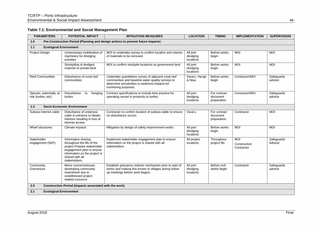
TCRTP – Ports Infrastructure
Environmental & Social Impact Assessment 48
August 2018 Final
Table 7.1: Environmental and Social Management Plan
PARAMETERS POTENTIAL IMPACT MITIGATION MEASURES LOCATION TIMING IMPLEMENTATION SUPERVISION
1.0 Pre-Construction Period (Planning and design actions to prevent future impacts)
1.1 Ecological Environment
Project Design Unnecessary mobilization of machinery for dredging activities
MOI to undertake survey to confirm location and volume of materials to be removed
All port dredging locations
Before works begin
MOI MOI
Stockpiling of dredged material on private land
MOI to confirm stockpile locations on government land All port dredging locations
Before works begin
MOI MOI
Reef Communities Disturbance of coral reef communities
Undertake quantitative survey of adjacent coral reef communities and baseline water quality surveys to determine sensitivities to sediment impacts for monitoring purposes.
Vava’u, Ha’api & Niua
Before works begin
Contractor/MOI Safeguards advisor
Species potentially at risk (turtles, etc)
Disturbance to foraging turtles
Contract specifications to include best practice for operating vessel in proximity to turtles.
All port dredging locations
For contract document preparation
Contractor/MOI Safeguards advisor
1.2 Socio-Economic Environment
Subsea internet cable Disturbance of undersea cable in entrance to Neiafu Harbour resulting in loss of internet access
Contractor to confirm location of subsea cable to ensure no disturbance occurs
Vava’u For contract document preparation
Contractor MOI
Wharf structures Climate impacts Mitigation by design of safety improvement works All port dredging locations
Before works begin
MOI MOI
Stakeholder engagement (SEP)
Information sharing throughout the life of the project Prepare stakeholder engagement plan to ensure information on the project is shared with all stakeholders.
Implement stakeholder engagement plan to ensure information on the project is shared with all stakeholders.
All project locations
Throughout project life
MOI
Construction Contractor
Safeguards Advisor
Community Grievances
Minor concerns/issues developing community resentment due to unaddressed project related concerns
Establish grievance redress mechanism prior to start of works and making this known to villages during follow up meetings before work begins.
All port dredging locations
Before civil works begin
Contractor Safeguards advisor
2.0 Construction Period (Impacts associated with the work)
2.1 Ecological Environment

TCRTP – Ports Infrastructure
Environmental & Social Impact Assessment 49
August 2018 Final
PARAMETERS POTENTIAL IMPACT MITIGATION MEASURES LOCATION TIMING IMPLEMENTATION SUPERVISION
Reef Communities Disturbance to benthic communities including ‘Utulei SMA and Oyster farms (Vava’u)
Contractor(s) to adhere to best practice dredging techniques to minimize sediment suspension during dredging activities.
Undertake monitoring survey of fish / benthic communities and water quality to determine whether any changes due to dredging activity
Sites adjacent to dredging locations
When dredging work work is being undertaken.
Contractor Safeguards advisor
Marine environment Runoff of silt from stockpiled dredged material on land to marine environment
Contractor to ensure runoff from dredged material stockpile is contained and treated prior to any discharge.
All port dredging locations
When work is undertaken.
Contractor Safeguards advisor
Spillage of fuel into marine environment
Refueling of excavator to be undertaken in contained area
Spill kit available for use.
All port dredging locations
When work is undertaken.
Contractor Safeguards advisor
Species of special Interest – turtles, etc
Disturbance to migrating turtles
Contractor to adhere to guidelines on minimally intrusiveness wrt turtles.
All port dredging locations
When work is under taken.
Contractor Safeguards advisor
2.2 Socio-Economic Environment
Workers Injury to personnel during dredging and safety improvement works activities
Site-specific training to workers. PPE to be provided. All port locations
When work is under taken.
Contractor Safeguards advisor
Local land owners Stockpiling of dredged material on private land
Ensure stockpile locations are located on Government land
All port dredging locations
When work is under taken.
Contractor Safeguards advisor
Coastal Resource Users - subsistence
Potential impact on movements of existing subsistence fishers
As per the contract specifications, contractor is to confine activities to as short a period as possible
Request Fisheries Authority to advise local fishers of dredging activities, dates, and avoidance measures.
All port locations
When work is under taken.
Contractor Safeguards advisor
Coastal shipping – recreational boating and commercial shipping
Disruption to shipping during mobilisation and dredging activities
Ensure shipping notice is issued, advising of dredging activities, dates, and safe clearance for other activities.
Request Port Authorities to advise local shipping of activities and avoidance measures.
Contractors to provide written statement that marine navigation lights and other national maritime measures are closely followed by contractors’ vessel at all times.
Port dredging locations
When work is under taken.
Contractor Safeguards advisor

TCRTP – Ports Infrastructure
Environmental & Social Impact Assessment 50
August 2018 Final
PARAMETERS POTENTIAL IMPACT MITIGATION MEASURES LOCATION TIMING IMPLEMENTATION SUPERVISION
Coastal Resource Users - all
Restricted access to Port facilities during safety improvement works
Contractor to issue notice to Mariners, Port Operations, ferry operators, tourism operators, commercial fishing fleets, etc, advising of timing and extent of works.
Contractor to prepare work plan that enables Port access to be maintained.
Port safety works locations
When work is under taken.
Contractor Safeguards advisor

TCRTP – Ports Infrastructure
Environmental & Social Impact Assessment 51
August 2018 Final
8 Grievance Redress Mechanism
A grievance redress mechanism (GRM) is presented below to ensure the Project’s social and
environmental safeguards performance. The purpose of the GRM is to record and address
any complaints that may arise during the implementation phase of the project. The GRM is
designed to address concerns and complaints promptly and transparently with no impacts
(cost, discrimination) on project affected people (APs). The GRM works within existing legal
and cultural frameworks, providing an additional opportunity to resolve grievances at the
local, project level.
The key objectives of the GRM are:
Record, categorize and prioritize the grievances;
Settle the grievances via consultation with all stakeholders (and inform those
stakeholders of the solutions)
Forward any unresolved cases to the relevant authority.
As the GRM works within existing legal and cultural frameworks, the GRM will have
community, project and RMI judiciary level redress mechanisms. Details of these
components are described as follows.
8.1 Grievance Redress Mechanism
Many project related grievances are minor and site-specific. Often they revolve around
nuisances generated during construction such as noise, dust, vibration, workers disputes etc.
These grievances may be community-specific or may relate to other users of the marine
areas where dredging and part safety improvement works are proposed.
For all sites the Project Contact Person (PCP) within the MOI PMU will receive, review, record
and address project related complaints.
In practice not many complaints are expected with potential some complaints likely to be
associated with construction impacts. Most will be received directly on site by the
Contractor’s Site Supervisor (CSS) who will endeavour to resolve them satisfactorily on site.
The CSS will inform the MOI Contact Person who will relay to the PCP at MOI/PMU the
complaints and outcomes, and of others not satisfactorily resolved. At this point the PCP
should take over.
The PCPs will, on receipt of each complaint, note date, time, name and contact details of the
complainant, and the nature of the complaint in the Complaints Register. The PCP will inform
the complainant of when to expect a response. They will then address the complaint to the
best of their abilities, as quickly as possible. Should the PCP not be able to resolve the
complaint to the satisfaction of the affected persons, they will then refer the complaint directly
to the MOI Project Manager (PM).
Complaints referred to the MOI PM will require immediate action to reach a resolution. The
aggrieved party will be informed of the course of action being taken, and when a result may
be expected. Reporting back to the complainant will be undertaken within a period of two
weeks from the date that the complaint was received.
If the complaint is not resolved to the satisfaction of the aggrieved party, the complaint will
then be referred by the MOI Secretary to the National Steering Committee (NSC). The NSC
will be required to address the concern within 1 month.
Should measures taken by the National Steering Committee fail to satisfy the complainant,
the aggrieved party is free to take his/her grievance to the Ombudsman’s Office, and the
Ombudsman’s decision will be final.
It is rare for a complaint to be unresolved after the Ombudsman’s decision. However, the
very last resort will be redress in the Courts.
Appropriate signage will be erected at works sites providing the public with updated project
information, summarising the GRM process and including contact details of the PCP. In

TCRTP – Ports Infrastructure
Environmental & Social Impact Assessment 52
August 2018 Final
addition, a comments box should be placed in the Airport facility as an additional avenue to
receive complaints. Anyone is able to lodge a complaint and the methods (forms, in person,
telephone, forms written in Tongan) should not inhibit the lodgement of any complaint.
The Complaints Register will be maintained by the PCP, who will log:
i) details and nature of the complaint;
ii) the complainant name and their contact details;
iii) date;
iv) corrective actions taken in response to the complaint.
This information will be included in MOI’s progress reports to the Bank.
Table 8.1 and Figure 8.1 outline the Project level grievance redress process.
8.2 Judiciary Level Grievance Redress Mechanism
The project level process will not impede affected persons access to the legal system. At
any time, the complainant may take the matter to the appropriate legal or judicial authority as
per the laws of Tonga.
Table 8.1: Grievance Redress Process – Project level
Stage Process Duration
1 The Aggrieved Party (AP) will take his/her grievance to Construction Site Supervisor (CSS) who will endeavor to resolve it immediately. Where AP is not satisfied, the CSS will refer the AP to the Project’s Contact Person (PCP). For complaints that were satisfactorily resolved by the CSS, he/she will inform the PCP and the PCP will log the grievance and the actions that were taken.
Any time.
2 On receipt of the complaint, the Project PCP will endeavor to resolve it immediately. If unsuccessful, he/she then notify PMU Project Manager
Immediately after logging of grievance.
3 The PMU Project Manager will endeavor to address and resolve the complaint and inform the aggrieved party. The Project Manager will also refer to the MOI Project Manager other unresolved grievances for his/her action.
2 weeks.
If the matter remains unresolved, or complainant is not satisfied with the outcome at the project level
4 The MOI Project Manager, will then refer matter to the National Steering Committee (NSC) for a resolution.
1 month.
5 If it remains unresolved or the complainant is dissatisfied with the outcome proposed by the NSC, he/she is free to refer the matter to the Ombudsman’s Office.
Anytime.
7 If the issue remains unresolved through the Ombudsman’s decision then the ultimate step will be for the Courts or Land Court respectively to deliberate. All decisions are final at this point.

TCRTP – Ports Infrastructure
Environmental & Social Impact Assessment 53
August 2018 Final
Figure 8.1: Flow Diagram showing Project level Grievance Redress Mechanism

TCRTP – Ports Infrastructure
Environmental & Social Impact Assessment 54
August 2018 Final
9 Appendices

Appendix 2: Dredged Material Volumes & Locations

Table 2A: Proposed dredging volumes and locations
Place Depth (m) Area (m2)
Total Volume (m3) Remark
A1 A2 A3 A4 A5 A6 A7 A8 A9
Niuatoputatu
0 to 2 0 0 1,760 714 1,430 0 0 0 0 3,904
These dredge areas are mainly at channel toward the leading light, 27 meters to the starboard and 20 meters to port when approaching
2 to 5 3,848 1,163 2,640 3,570 2,145 180 1,425 43 1,081 16,094
Vava'u 0 to 2 9,600 0 0 0 0 0 0 0 0 9,600
Area A1 are mainly for small local boats in Vava'u but it will be dredge down to the same depth as area A2 to cater for other deeper draft vessel. Area A2 will then dredge with area A3 to same depth for the use of foreign vessel with deeper draft
2 to 5 0 38,400 0 0 0 0 0 0 0 38,400
5 to 10 0 0 64,000 4,950 0 0 0 0 0 68,950
Ha'apai 0 to 2 0 0 2,520 0 0 0 0 0 0 2,520
Area A1 & A2 outside the harbour must be dredge down to 5m so that dredging within the harbour could go down to match A1 & A2 for deep draft vessel 2 to 5 41,400 13,500 10,800 0 0 0 0 0 0 65,700
Eua 0 to 2 4,000 0 0 0 0 0 0 0 0 4,000
The estimation of the volume to dredge at 'Eua harbour would come with the most error since the accuracy of the source of information were it was collected is very low 2 to 5 6,000 10,512 0 0 0 0 0 0 0 16,512
Legend Total Volume (m3)
0 to 2 20,024
These are priority area which may be of interest to local boat in the area as well as to Domestic ferries
2 to 5 136,706
These area basically intended for the Domestic ferries or other vessels with deeper draft
5 to 10 68,950
This area in Vava'u Harbour only are intended for Internation vesse with deeper draft than 5m. The draft restriction in Vava'u is 6m and if it require to dredge the wharf for deeper draft vessel, Galloway Rock at 'Utulei will have to go as deep as required for the wharf

Figure 2A: Nuiatoputapu channel entrance

Figure 2B: Taufa’ahau Port and channel entrance at Ha’apai

Figure 2C: Halaevalu Port and channel entrance at Vava’u

Figure 2D: Nafanua Port at ‘Eua

Appendix 3: Marine Ecological Resource Assessment
