tolowa dunes state park draft resources …€¦ · the purpose of tolowa dunes state park is to...
TRANSCRIPT

Tolowa Dunes SP Resources Summary & Reclassification DRAFT August 25, 2010
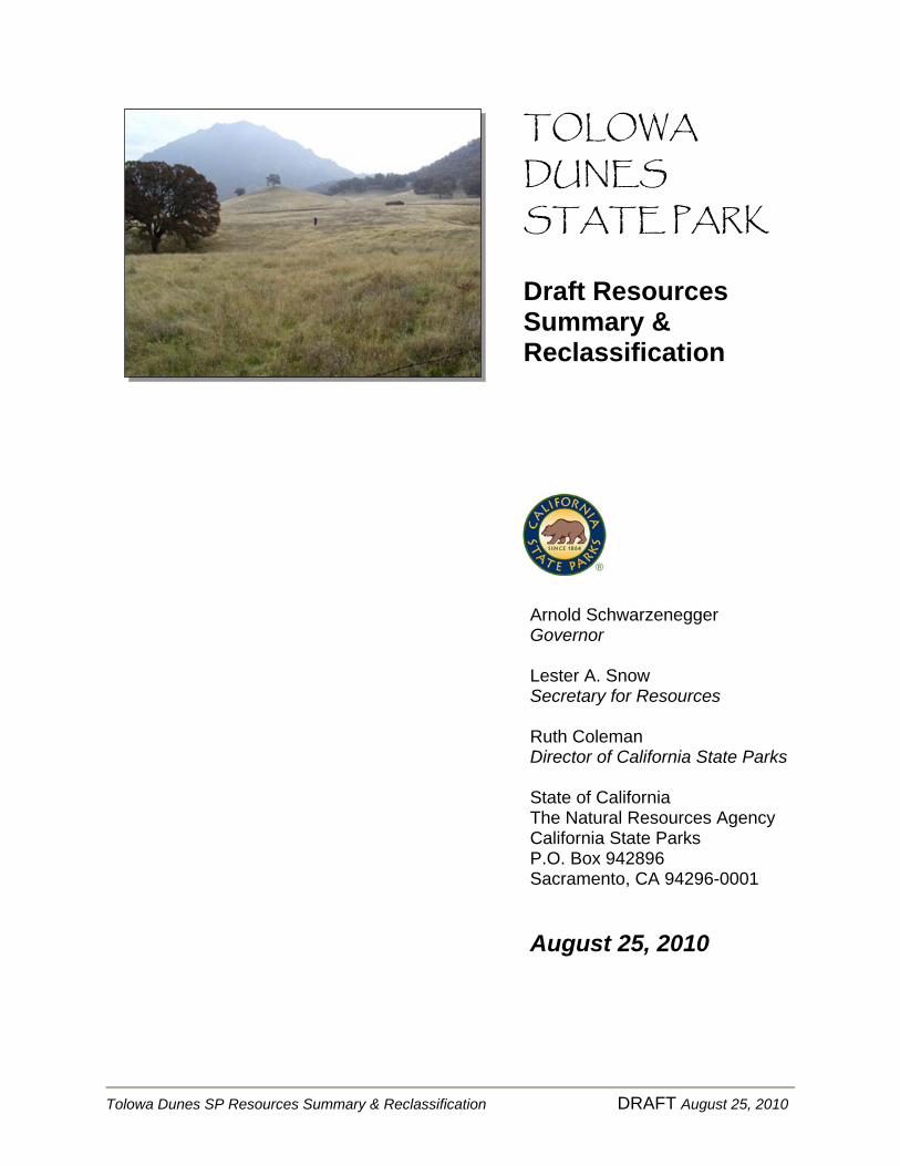
TOLOWA DUNES STATE PARK
Draft Resources Summary & Reclassification
August 25, 2010
Tolowa Dunes SP Resources Summary & Reclassification DRAFT August 25, 2010
TOLOWA DUNES STATE PARK
Draft Resources Summary & Reclassification
Arnold Schwarzenegger Governor
Lester A. Snow Secretary for Resources Ruth Coleman Director of California State Parks State of California The Natural Resources Agency California State Parks P.O. Box 942896 Sacramento, CA 94296-0001
August 25, 2010
Tolowa Dunes SP Resources Summary & Reclassification DRAFT August 25, 2010
TABLE OF CONTENTS INTRODUCTION.............................................................................................................................. 1
Classification Purpose ..............................................................................................1
Classification and Naming Process ......................................................................1
PROJECT DESCRIPTION ....................................................................................................... 3 DECLARATION OF PURPOSE........................................................................................ 4 RESOURCES SUMMARY ..................................................................................................... 5
Aesthetic Resources and Spirit of Place ..........................................................5
Recreation Resources ...............................................................................................7
Cultural Resources.....................................................................................................9
Natural Resources ...................................................................................................18
POTENTIAL CLASSIFICATION............................................................25
Discussion and Analysis........................................................................................25
Subclassifications………………………………………………………………………………………26
Area of Consideration...........................................................................................27
PROPOSED NAMES................................................................................................................27
Alternative Names Considered..........................................................................27
SELECTED REFERENCES ............................................................................................28
APPENDIX A – Map (Area of Consideration) ......................................................................31
APPENDIX B - Commission Statement of Policy...................................................................32
Tolowa Dunes SP Resources Summary & Reclassification DRAFT August 25, 2010
Tolowa Dunes State Park Location Map

Tolowa Dunes SP Resources Summary & Reclassification 1 DRAFT August 25, 2010
INTRODUCTION
Classification Purpose
The California Public Resources Code, Section 5002.1, requires that an inventory of scenic, natural and cultural features be provided to the California State Parks and Recreation Commission when classifying a unit of the State Park System. This Resources Summary and Reclassification is intended to provide the Commission with the necessary information for classification as specified in Article 1.7 of the Public Resources Code. (Also, see Commission Policy II.2 located in Appendix B). This Resources Summary and Reclassification establishes resource values and provides an overview of the project area. Information contained in this document has been compiled from various reports and field investigations. This information will also be useful to assist in developing resource policies, resource management programs, and as background information for land use planning, maintenance, interpretation, and operations. Additional and more detailed resource inventory information will be developed during the preparation of a future General Plan and specific management plans.
Classification and Naming Process The following describes the primary tasks for this naming and classification process:
• Identify significant resource values and opportunities (Resource Summary)
• Evaluate potential unit classification(s)
• Determine appropriate unit classification(s) and name(s)
The following are expanded descriptions of these tasks, performed during this process:
Resource Summary In 2001, the resources team conducted initial research and field
investigations, evaluated resource significance, and prepared a summary of the Park’s natural, cultural, recreational, and aesthetic resources. This resource summary was recently updated and serves as the inventory of
Tolowa Dunes SP Resources Summary & Reclassification 2 DRAFT August 25, 2010
features for the purpose of determining the desired level of resource protection and appropriate unit classification.
As part of the resource summary and evaluation, the planning team
evaluated past and present uses and addressed public access, park development and recreational potential.
Unit Classification and Name
The State Park and Recreation Commission in August 2001 classified Tolowa Dunes as a state park. Since 2001, a more detailed ecological assessment was made, and a draft management plan was prepared for protection of natural and cultural resources. Evaluating the potential for reclassification of a portion of the State Park to a State Recreation Area to allow waterfowl hunting was the primary focus of this effort. The Department will evaluate the purpose and benefits of the different possible classifications and provide a recommendation and justification for the appropriate change in classification for a portion of Tolowa Dunes State Park (TDSP) or potential sub classifications. In addition to determining the unit classification, alternative unit names will be considered, with a preferred name recommended to the Commission with supporting justification.
This classification and naming process also includes opportunities for the public to provide input and make recommendations for their preference of park names and desirable classification.

Tolowa Dunes SP Resources Summary & Reclassification 3 DRAFT August 25, 2010
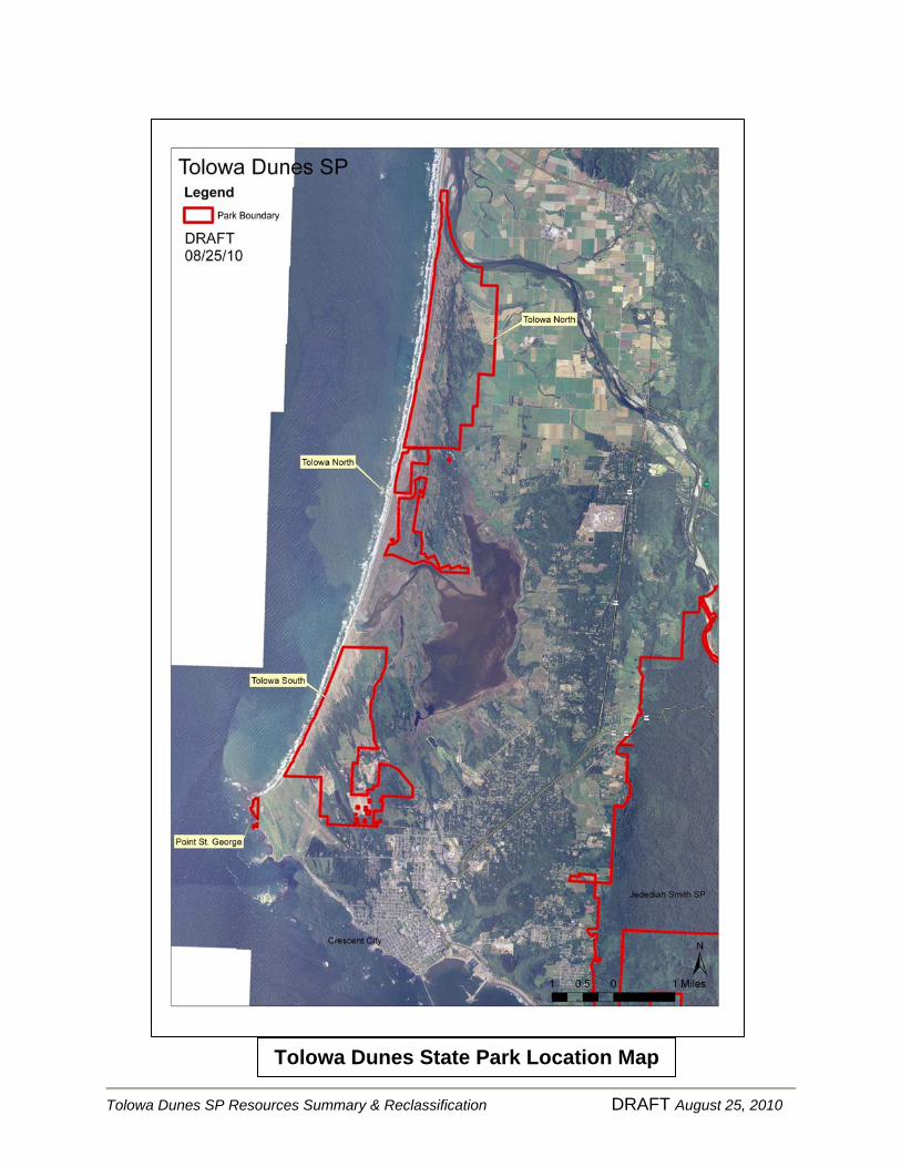
PROJECT DESCRIPTION Tolowa Dunes State Park (TDSP) is located on the northwest coast of California
in Del Norte County, just south of the Oregon border. TDSP is an integral part of 11,000 contiguous acres of protected public lands that stretch from Point Saint George to the mouth of the Smith River. TDSP contains some of the finest wetland and dune habitat on California’s northern coast. Located far from urban centers, TDSP is positioned adjacent to the Pacific Coast between the mouth of the Smith River and Crescent City. TDSP’s 4,310 acres are divided into three sections: the northern section (Tolowa North) is between the mouth of the Smith River and Kellogg Road; the southern section (Tolowa South) is between the southern shores of lakes Earl and Tolowa to the Crescent City Airport; and the third section, Point Saint George, is just west of Crescent City. Adjacent and between these areas is land managed by the California Department of Fish and Game, Del Norte County, and private property. This report focuses on the Tolowa North section, where the area proposed for reclassification is located. Established in 2001 to protect one of California’s largest undeveloped coastal areas, TDSP contains a diverse assortment of birds, animals, and plant life. Marine mammals, such as sea lions and harbor seals, can be spotted along the coast and on the beaches; gray whales migrate from Alaska to Baja California and back. The coastal beaches are built and rebuilt by the powerful tidal currents, and ocean winds mold new shapes in the dunes. Great displays of wildflowers can be seen in the spring and early summer, including the sensitive sand dune phacelia, which is only known in California from the lakes Earl and Tolowa area. TDSP coastal dunes support many upland and wetland habitats. Among these are native dune herbaceous communities, conifer forests, meadows dominated by exotic grasses, and areas dominated by European beach grass, all of which are interspersed by critical and diverse wetlands habitats (Mad River Biologists 2009). The area surrounding lakes Earl and Tolowa is rich in cultural resources with more than 19 known archaeological and two historic districts that are listed on the National
Photo © F.L. Hiser Jr. (seeking photo permission from DFG)
Tolowa Dunes SP Resources Summary & Reclassification 4 DRAFT August 25, 2010
Register of Historic Places. These sites indicate a 2,000 year span of human occupation (Gould 1966). The unit also includes Point Saint George, a National Register of Historic Places site of the famous 1861 paddle wheeler Brother Jonathan shipwreck. The area serves as an important stopover on the Pacific flyway for thousands of migrating ducks, geese and swans. Salmon and steelhead, including the State and Federally Threatened coho in the Smith River; cutthroat trout, Starry flounder, and the Federally Endangered tidewater goby in lakes Earl and Tolowa, and non-native bass and crappie can be found in Dead Lake. Hundreds of species of birds, including the once Federally Endangered Aleutian cackling goose and the peregrine falcon, can be seen in the TDSP dunes, dune forests, and wetlands. Deer, coyote and raccoons may be spotted along the many miles of trails that traverse the Park. From certain vantage points in the Park, jagged summits are visible miles inland, rising 7,300 feet in elevation at the summit of Preston Peak, in adjacent Siskiyou County. The Park’s diversity of wildlife, natural beauty and many recreational opportunities attracted 25,807 visitors in 2008/09 Fiscal Year.
DECLARATION OF PURPOSE
The Declaration of Purpose defines the purpose of a unit and broad management goals. It establishes long range management objectives consistent with the unit classification. The Declaration of Purpose for Tolowa Dunes State Park is:
The purpose of Tolowa Dunes State Park is to preserve the natural, cultural, aesthetic, and recreational resources of the dune and wetland habitats, and to preserve the cultural and historic resources in the vicinity of lakes Earl and Tolowa, and make them available to the people, forever, for their education and enjoyment. The Department of Parks and Recreation will protect, manage and restore the resources and values of the State Park, and provide appropriate programs, facilities and opportunities for public use consistent with preservation of the resource values.
If the California State Parks Commission adopts a resolution to reclassify a portion of this unit as a State Recreation Area (SRA), as outlined in PRC 5019.56(a), a separate Declaration of Purpose will be established for the new SRA as follows:
The purpose of New Name State Recreation Area is to provide recreational opportunities, including waterfowl hunting, in cooperation with the California Department of Fish and Game. The cultural and natural resource preservation and protection in this SRA will continue to be managed to preserve their important resource values.
Tolowa Dunes SP Resources Summary & Reclassification 5 DRAFT August 25, 2010
RESOURCES SUMMARY
Aesthetic Resources and Spirit of Place Aesthetic Resources Throughout the area, aesthetic resources abound. Sequences of varying terrain, wildlife habitat and sites of cultural significance combine spatially to provide high quality “re-creational” experiences. The ocean’s overwhelming expanse, power and noise are temporarily countered by the discovery of a tiny unbroken shell washed ashore on a broad lonely beach.
…Dancing wind driven sand migrates to the crest of a primary dune leaving endless patterns amid the tenacious sand verbena and beach primrose. …Sudden calm reveals the muffled chuckles of resting puddle ducks amid the pondweed and cattails of an adjacent dune hollow. …A dark and unidentified silhouette darts into tall woodland shadows while the pungent aroma of Douglas fir announces a nearby forest. …From forest edge, views of distant mountains, and the marks of society, are occasionally interrupted by gaggles of Aleutian Canada geese, avian reminders of a delicate global balance. …An unexpected encounter with an isolated cemetery gives somber meaning to a place called…Yontocket.
Spirit of Place
Tolowa Dunes is composed within a landscape of spectacular natural, cultural, and aesthetic resources. Wild and dynamic, the true character of this richly natural and cultural area can not be perceived through a singular image. Here, beaches are built and rebuilt by the powerful tidal currents, while ocean winds sculpt new shapes in the ancient dunes daily. Beach grass waves while tufts of colorful dune tansy and beach strawberry struggle to sustain. On the ocean horizon, jets of silver spray signal migrating California gray whales. Inland, tall stands of blue-black Sitka spruce rise to the distant snowcapped mountains as silent sentinels for black-tailed deer browsing in the lushly vegetated emerald green meadows below. The sweet, pungent scent of the forest fills the air washed clean by ocean breezes. In nearby ponds, shimmering reflections of passing clouds are broken only by the wake of a passing river otter. Overhead, the muted honking of a small flock of Aleutian cackling geese intensifies into
Tolowa Dunes SP Resources Summary & Reclassification 6 DRAFT August 25, 2010
a chorus of thousands, preening and resting on adjacent grasslands. Along the lake’s edge, a pair of mating western grebes dart in tandem across the waters surface. Beneath them, in the waning light of the lakes’ depths, the iridescent form of a passing salmon is revealed. From the distance, the raucous cries of flashing white gulls and terns can be heard while the dark brown silhouette of an osprey slowly glides on broad powerful wings to its perch atop an old lone snag. “As moments pass to seasons, the diverse resources of this unique, and potentially endangered, landscape become increasingly important. Within California, there are no other coastal landscapes providing the same qualities of natural light, visual patterns and textures, wild and dynamic action, temperature, scent, sounds, expanding vistas or focused views. Combined, the rich and varied resources found within and around the lakes Earl and Tolowa evoke a “spirit of place” that reconnects us with the earth.” (DPR Resource Summary, et al. 2001)
Tolowa Dunes SP Resources Summary & Reclassification 7 DRAFT August 25, 2010
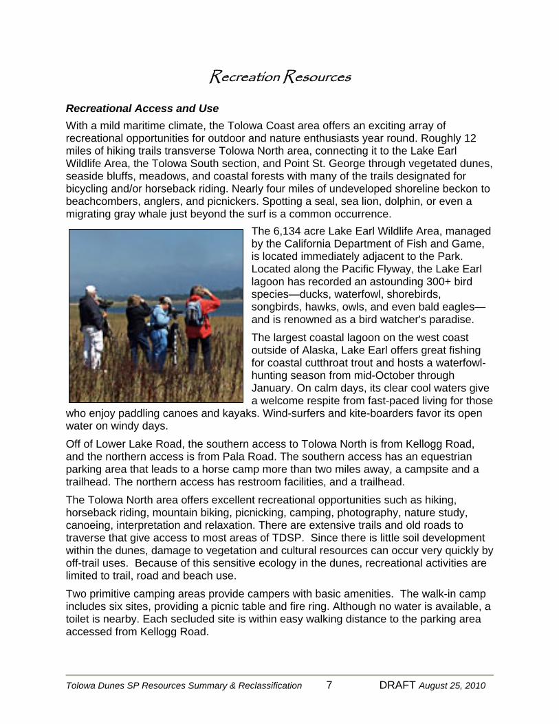
Recreation Resources Recreational Access and Use With a mild maritime climate, the Tolowa Coast area offers an exciting array of recreational opportunities for outdoor and nature enthusiasts year round. Roughly 12 miles of hiking trails transverse Tolowa North area, connecting it to the Lake Earl Wildlife Area, the Tolowa South section, and Point St. George through vegetated dunes, seaside bluffs, meadows, and coastal forests with many of the trails designated for bicycling and/or horseback riding. Nearly four miles of undeveloped shoreline beckon to beachcombers, anglers, and picnickers. Spotting a seal, sea lion, dolphin, or even a migrating gray whale just beyond the surf is a common occurrence.
The 6,134 acre Lake Earl Wildlife Area, managed by the California Department of Fish and Game, is located immediately adjacent to the Park. Located along the Pacific Flyway, the Lake Earl lagoon has recorded an astounding 300+ bird species—ducks, waterfowl, shorebirds, songbirds, hawks, owls, and even bald eagles—and is renowned as a bird watcher's paradise. The largest coastal lagoon on the west coast outside of Alaska, Lake Earl offers great fishing for coastal cutthroat trout and hosts a waterfowl-hunting season from mid-October through January. On calm days, its clear cool waters give a welcome respite from fast-paced living for those
who enjoy paddling canoes and kayaks. Wind-surfers and kite-boarders favor its open water on windy days. Off of Lower Lake Road, the southern access to Tolowa North is from Kellogg Road, and the northern access is from Pala Road. The southern access has an equestrian parking area that leads to a horse camp more than two miles away, a campsite and a trailhead. The northern access has restroom facilities, and a trailhead. The Tolowa North area offers excellent recreational opportunities such as hiking, horseback riding, mountain biking, picnicking, camping, photography, nature study, canoeing, interpretation and relaxation. There are extensive trails and old roads to traverse that give access to most areas of TDSP. Since there is little soil development within the dunes, damage to vegetation and cultural resources can occur very quickly by off-trail uses. Because of this sensitive ecology in the dunes, recreational activities are limited to trail, road and beach use. Two primitive camping areas provide campers with basic amenities. The walk-in camp includes six sites, providing a picnic table and fire ring. Although no water is available, a toilet is nearby. Each secluded site is within easy walking distance to the parking area accessed from Kellogg Road.
Tolowa Dunes SP Resources Summary & Reclassification 8 DRAFT August 25, 2010
A ride-in horse camp, also available to other users, is located about one mile southwest of the Pala Road trailhead. The camp includes corrals, picnic tables, fire rings, non-potable water and toilets. Volunteers from the Tolowa Dunes Stewards provide interpretive activities in TDSP. Guided walks, talks and slide programs, as well as arranged auto tours, are offered during the summer months. Seasonal waterfowl hunting was legally permitted within the lakes Earl and Tolowa area. DFG allows hunting with shotguns for most waterfowl along the shore and on open waters of its Lake Earl Wildlife Area. Hunters may use decoys to lure game to blinds they erect along the shoreline, or to non-motorized skull boats on the lakes’ surface. Trained dogs retrieve downed ducks. Mallards and teal are among popular species, but the big lagoon, with its fluctuating water levels and wind exposure, can be challenging to hunt. Hunting regulations are established by DFG, annually, in a process intended to conserve waterfowl populations. Ducks could be hunted for 40 days on Saturday, Sunday, and Wednesday, from late October through January 31. The goose hunting season extended from early November to January 31. Hunters could have up to seven ducks and six geese in their possession. Heavy rainfall in the fall fills several ponds within Tolowa Dunes. Once flooded, these ponds attract a variety of waterfowl. Local hunters, especially youth and older hunters, valued these waterfowling opportunities because it was a more isolated, quieter experience that did not require a boat, as does much of the more traditional hunting at lakes Earl and Tolowa. Hunting had occurred on Tolowa Dunes’ Yontocket Slough and the ponds prior to Tolowa Dunes being classified as a state park.
Off-Highway Vehicle (OHV) use is strictly controlled. Only street-legal vehicles are allowed on the beach wave slope (wetted sand) north of Kellogg Road from sunrise to sunset. The speed limit on the wave slope is 15 mph.

Tolowa Dunes SP Resources Summary & Reclassification 9 DRAFT August 25, 2010
Cultural Resources
Figure 1. Tolowa sweathouse at village of Šxme ca. 1910 (Fred Endert photograph, in Gould 1978:131)
INTRODUCTION
The cultural resources located in TDSP northern section reflect the close association that the Tolowa people had and have with this location. To the Tolowa, for whom the Park was named, this area is known as Yan’-daa-k’vt or Yontocket, and is the center of their world and the birthplace of creation. The former village sites, archaeological remains, features, and religiously significant places have been integral components to their way of lives for thousand of years as evidenced by archaeological data. To the Tolowa this place has been sacred since time immemorial.
PREHISTORY This portion of Northwest California, in which TDSP is located, has experienced three identified time periods and adaptive modes throughout prehistory (Fredrickson 1984; Hildebrandt and Hayes 1993; Hildebrandt and Levulett 2003). These have been named and are collectively recognized as the Borax Lake Pattern (8000-3500 BP), the Mendocino Pattern (3500-1500 BP) and the Gunther Pattern (post-1500 BP). The Contact Period is generally accepted as 1850-1852, though encounters with Euro-Americans occurred as early as 1828 (Gould 1972).
Borax Lake Pattern:

Tolowa Dunes SP Resources Summary & Reclassification 10 DRAFT August 25, 2010
The earliest forms of occupation documented in Northwest California Prehistory date back to 8000 years before present and are identified as the Borax Lake Pattern. Large wide-stemmed projectile points with indented bases, serrated bifaces, ovoid flake tools, handstones, milling slabs, and edged-flaked spalls, are representative artifacts of this assemblage. Borax Lake sites have been found in sites “located across a wide range of environmental contexts” (Jones and Klar 2007). In nearby Jedediah Smith Redwoods State Park, deposits have been identified on the Smith River that date to this pattern (Tushingham, et al, 2008).
Mendocino Pattern: Around 5,000 years before present, a new manifestation of a prehistoric society emerges in Northwestern California. Collectively, this is recognized as the Mendocino Pattern. Artifacts of this assemblage commonly include side-notched, corner-notched, and concave-base projectile points, handstones, milling slabs, various types of flake tools and cobble tools (Jones and Klar 2007). In contrast to earlier multi-activity Borax Lake sites, Mendocino Pattern sites emerge as specialized and more sedentary. Gould identified Mendocino Pattern archaeological data at Point St. George within Tolowa Dunes State Park dating to 2260 (+/- 210) years before present (Gould 1966a, 1972). Gunther Pattern: The Gunther Pattern or Late Period is seen on the northwest coast of California from approximately 1500 years before present to the Contact Period. Significant changes occur in the archaeological record during this time period, most evidenced by major sedentary activities and village establishment. Excavations have demonstrated an artifact assemblage consisting of small arrow points, triangular spear and harpoon points, ground and polished stone artifacts, including pestles, mauls, hammerstones, and mortars. Other artifacts representative of this period include stone net sinkers, steatite bowls and pipes, and wealth items such as obsidian blades and zoöforms or “slave killers” (Jones and Klar 2007). Artifacts from this pattern have been identified in archaeological sites located within Tolowa Dunes State Park (Burns, et al 2008). Contact Period: The Contact Period in the northwestern portion of the state took place rather late compared to most of California. The first recorded direct contact between the Tolowa and whites did not occur until 1828 when Jedediah Smith traveled through the area trapping fur bearing mammals. However, there is evidence that Tolowa people obtained trade goods from early explorers, either directly and or indirectly from other tribes. The discovery of gold on the Trinity and Klamath Rivers inspired thousands of miners to flood the region in the 1850s. The contact period was devastating to local Indian populations. The Tolowa suffered four horrific massacres in the 1850s. One such incident took place one night at Yontocket during a religious celebration where the majority of the tribe was gathered. On the third night of the celebration approximately 30 Americans encircled the village and indiscriminately slaughtered 450 to 600 people,
Tolowa Dunes SP Resources Summary & Reclassification 11 DRAFT August 25, 2010
including numerous women and children. Only three survivors were reported. One of the survivors told of how the morning after he found the Yontocket Slough “red with the blood of his people.” (Bommelyn 1985)
ETHNOGRAPHY
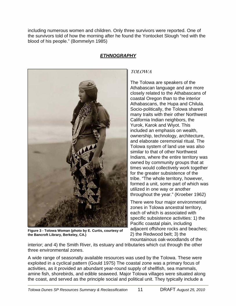
TOLOWA The Tolowa are speakers of the Athabascan language and are more closely related to the Athabascans of coastal Oregon than to the interior Athabascans, the Hupa and Chilula. Socio-politically, the Tolowa shared many traits with their other Northwest California Indian neighbors, the Yurok, Karok and Wiyot. This included an emphasis on wealth, ownership, technology, architecture, and elaborate ceremonial ritual. The Tolowa system of land use was also similar to that of other Northwest Indians, where the entire territory was owned by community groups that at times would collectively work together for the greater subsistence of the tribe. “The whole territory, however, formed a unit, some part of which was utilized in one way or another throughout the year.” (Kroeber 1962) There were four major environmental zones in Tolowa ancestral territory, each of which is associated with specific subsistence activities: 1) the Pacific coastal plain, including adjacent offshore rocks and beaches; 2) the Redwood belt; 3) the mountainous oak-woodlands of the
interior; and 4) the Smith River, its estuary and tributaries which cut through the other three environmental zones. A wide range of seasonally available resources was used by the Tolowa. These were exploited in a cyclical pattern (Gould 1975) The coastal zone was a primary focus of activities, as it provided an abundant year-round supply of shellfish, sea mammals, amine fish, shorebirds, and edible seaweed. Major Tolowa villages were situated along the coast, and served as the principle social and political unit. They typically include a
Figure 3 - Tolowa Woman (photo by E. Curtis, courtesy of the Bancroft Library, Berkeley, CA.)
Tolowa Dunes SP Resources Summary & Reclassification 12 DRAFT August 25, 2010
“rich man” who had the greatest amount of regalia and could hold dances. Inter-village and intertribal alliances were formed through marriage with outlying groups, including Yurok, Karok, and the more northerly Chetco (Tushingham 2008). Most villages were occupied by the entire population for nine to ten months of the year (winter, spring, summer), but would disperse at the other times of the year. People occupied redwood plank houses while in the major villages. The houses were made of upright planks built over a shallow semi-subterranean house pit, with a hearth built into the center. Temporary summer camps would be established in the late summer near the beach to harvest the surf smelt and other marine resources. Smelt were caught in V-shaped dip nets and laid out on logs or next to a slow burning fire to dry. The fish were then placed in carrying baskets and hauled back to villages and placed in storage baskets within the houses. The fall would see families venture inland to the riverine habitat and oak woodland to procure salmon and acorns. Salmon were split and smoked, the halves were placed on a backframe between alternating layers of fern. Acorns were placed in carrying baskets and along with the processed salmon, transported to the permanent village by the end of November for use during the winter months (Tushingham 2008).
ARCHAEOLOGICAL RESOURCES TDSP is located within the ancestral territory of the Tolowa people. The property was part of the Tolowa settlement system described above and included several documented villages, camps, hunting and gathering areas, and ritual or religious places. Waterways and trails provided transport between these locations. Two nationally registered historic districts and twenty-three cultural and archaeological sites are present within the boundaries of TDSP, as are many cultural features and isolates. Four of these sites are classified as villages Two are located in Tolowa-North: Yontocket (DNO-19), Troolet (DNO-247). The Yontocket Historic District was entered on the National Register of Historic Places in 1973 and is located in the northern section of the Park (above Lake Earl). The District includes the villages of Yontocket (DNO-19), and Troolet (DNO-247) and the nearby sites of Te’ligemiLyagi:a, an important place for shamanistic activities south of Yontocket, and Tu’tinwure, a complex of sacred pools which one was lucky to bathe in except for one which harbored a huge sea serpent. It is approximately 1900 acres (King 1973). In December 1973, when the property was still in private ownership, the Yontocket Historic District was nominated to the National Register of Historic Places to recognize its significance as the center of the Tolowa world and as an archaeological site, and to memorialize a brutal massacre. In his nomination to the Register, Tom King, Northwest District Archaeologist, Society for California Archaeology, concluded: “The proposed district is...a vitally important place in terms of Tolowa religion, a significant [and] fairly
Tolowa Dunes SP Resources Summary & Reclassification 13 DRAFT August 25, 2010
intact residential site, and the site of an historical event whose memory should be preserved as an example of the barbarism of armed conquest.” (King 1973). In a survey of coastal sites in TDSP, a large coastal fish and shellfish processing camp ethnographically known as “Sweetwater” (DNO-22/XX7) was recorded. A hearth containing a massive amount of surf fish bone and several varieties of shellfish was recorded. A date of approximately 200 years before present was obtained from wood charcoal from the hearth. (Tushingham 2006) Yontocket Virtually, all cultures of the world hold a religious belief in the axis mundi, or world axis, which is the mythological center of the world that connects Heaven and Earth. Many cultures believe that the axis mundi is a particular place, such as a mountain or other promontory. For example, the Temple Mount, site of the Dome of the Rock, is also holy to Judaism and Christianity. Other nearby sites that are considered sacred, and are on hills, include the Mount of Olives and Calvary. Yontocket is such a place. It is the origin of the Tolowa genesis. (Tushingham 2006) The village of Yontocket, located in the northern section of TDSP, is the axis mundi of the Tolowa people. As such, it is one of the most sacred and important cultural sites in Tolowa ancestral territory. Yontocket is regarded as the center of the Tolowa world, their place of origin, the location of the first white Redwood tree, sacred pools and of the sacred sweat house associated with the annual first-salmon rite. Yontocket District towns, economic sites and ritual or religious locations A Village District was known as “yvth-‘in”, and translates to “that which is looked over.” Traditional land use worked under the auspices of the Village District, which consisted of one or more villages and satellite communities and included many places (whether owned or not) of economic, ritual or religious importance that were under the control or jurisdiction of the lineal groups associated with the District. The Yontocket village was the core of the Yontocket village district, which included many nearby sites, only a few of which are on the National Register. (Tushingham 2006) The Burnt Ranch Massacre Curtis wrote that “With the Tolowa of Smith River, there was trouble almost from the very beginning” with violence recorded as early as 1851 (Curtis 1925:91). In 1853, the first of a series of devastating massacres occurred at the sacred village of Yontocket, the largest Tolowa settlement at the time. That winter, a large number of people were gathered for a World Renewal Dance. At dawn, on the third day of the ten day celebration, an armed group of men from Crescent City who suspected the Indians for the murder of several prospectors, set fire to the houses. Men, women and children were gunned down as they fled the burning houses. Hundreds died, and only a few Tolowa survived the massacre. One man survived by escaping to a nearby slough. He took cover for hours, and later reported: “…I could hear them people talking and laughing. I looked in the water, and the water was just red with blood, with people floating around all over.”
Tolowa Dunes SP Resources Summary & Reclassification 14 DRAFT August 25, 2010
One Tolowa account of the tragedy was given by Amelia Brown to Gould:
“I just hear this, I wasn’t there myself. They (the Indians) had one old sweathouse, only used this at certain times. They was having a big time. The people were gambling, the people from Pebble Beach and even Tututni (Athabaskan speaking Indians immediately to the north of the Tolowa). They had a big celebration there one night. The white people were all around, they just watched. Then they set fire to the place. Women try to get away, they grab ‘em and throw ‘em in the fire. Take pot shots at ‘em when they try to run. Just two men got away. They rand down to the slough, dived in, swam along underwater, take breath, dive again till got away to a little island there. Later on these men fought with the whites. This was at the village of Yonktakut, that’s how got the name, ‘Burnt Ranch.’ (Amelia Brown in Gould 1966b:35-36; Tushingham 2006).
HISTORY Since the Yontocket Massacre, the area became known as Burnt Ranch, as the Indians dwellings were all burned. Euro-American owners of the lands encompassing Yontocket from the time of settlement to State Parks ownership include the Smythes; Felix Scott; John and Ann Rigg and their partners Marion Scott and Peter Smythe; John Hegler and sons Frederick and Edwin; Charles Pala; the Masonic Lodge; George Tryon; Millard Johnson; and Loren Bliss. These early settlers of the lower Smith River engaged primarily in ranching activities. Stock-raising, dairy, and agriculture all were employed one time or another by these various land owners. An article in the Crescent City News on October 25, 1895 stated
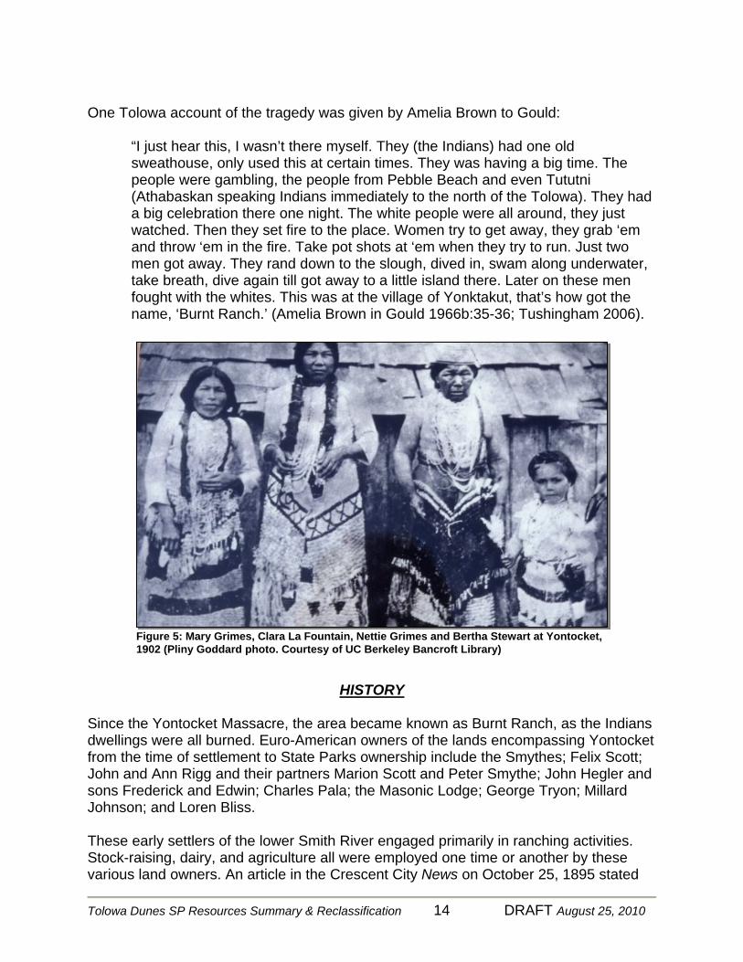
Figure 5: Mary Grimes, Clara La Fountain, Nettie Grimes and Bertha Stewart at Yontocket, 1902 (Pliny Goddard photo. Courtesy of UC Berkeley Bancroft Library)

Tolowa Dunes SP Resources Summary & Reclassification 15 DRAFT August 25, 2010
that “No better creamery butter is sold in the state than the butter from the Yontockett dairy.” (Van Kirk 2009) The last of the Tolowa to live at Yontocket, Raleigh (Rolly) Grimes died in 1951. Millard Johnson reportedly burned all the remaining Indian structures after this. Loren Bliss purchased the land from Johnson in 1957. In 1961, with consent from Bliss, members of the Yontocket Cemetery Committee constructed the first fence around the cemetery. In 1964 anthropologist Richard Gould, extended the fence to include additional burials. Bliss operated his ranch into the 1970s. (Van Kirk 2009) California State Parks The Yontocket Ranch was acquired by the State in 1979 (Official Records 236:263, 27 June 1979). In 1984, with a focus on recreation and public access, State Parks management authorized construction of a parking lot and restroom adjacent to the Yontocket village site and cemetery. Yontocket descendants were concerned that such easy access to the cemetery would result in vandalism. On January 30, 1985, three individuals were observed looting graves, resulting in a 100-square-foot excavation. In light of this event, State Parks agreed to move the parking lot a half mile to the east. During the summer of 1985, State Parks Archaeologist Breck Parkman arranged to have Bar-O boys work at the cemetery, covering it with chain link fencing and three feet of soil, and constructing a sturdy redwood fence around the boundary (Parkman 2006). Protection of the Yontocket Historic District as a place of great significance to Tolowa people is now part of State Parks management. But there is also recognition that this is not simply a historic site—a museum piece—but a place to continue traditional cultural practices. An informal agreement was reached in 1985 between the Tolowa and the North Coast District that echoes DPR policy in regards to Pioneer Cemeteries, where those individuals associated and or born at the location may be interred within the cemetery. In recent years, three Yontocket descents and the husband of one have been buried there (Kirk 2009).
Figure 4. Cemetery fence at Yontocket (Green 2009)
Tolowa Dunes SP Resources Summary & Reclassification 16 DRAFT August 25, 2010
“Yontocket is a very special place and I feel that if the State of California is to be the owner of this property, the only way that this could be accomplished is that the Indians who lived there should have a place there, I do feel that the home that was in our family should be protected. This is the only way that our cemetery can be protected. The Park personnel cannot protect it. We know this…No one
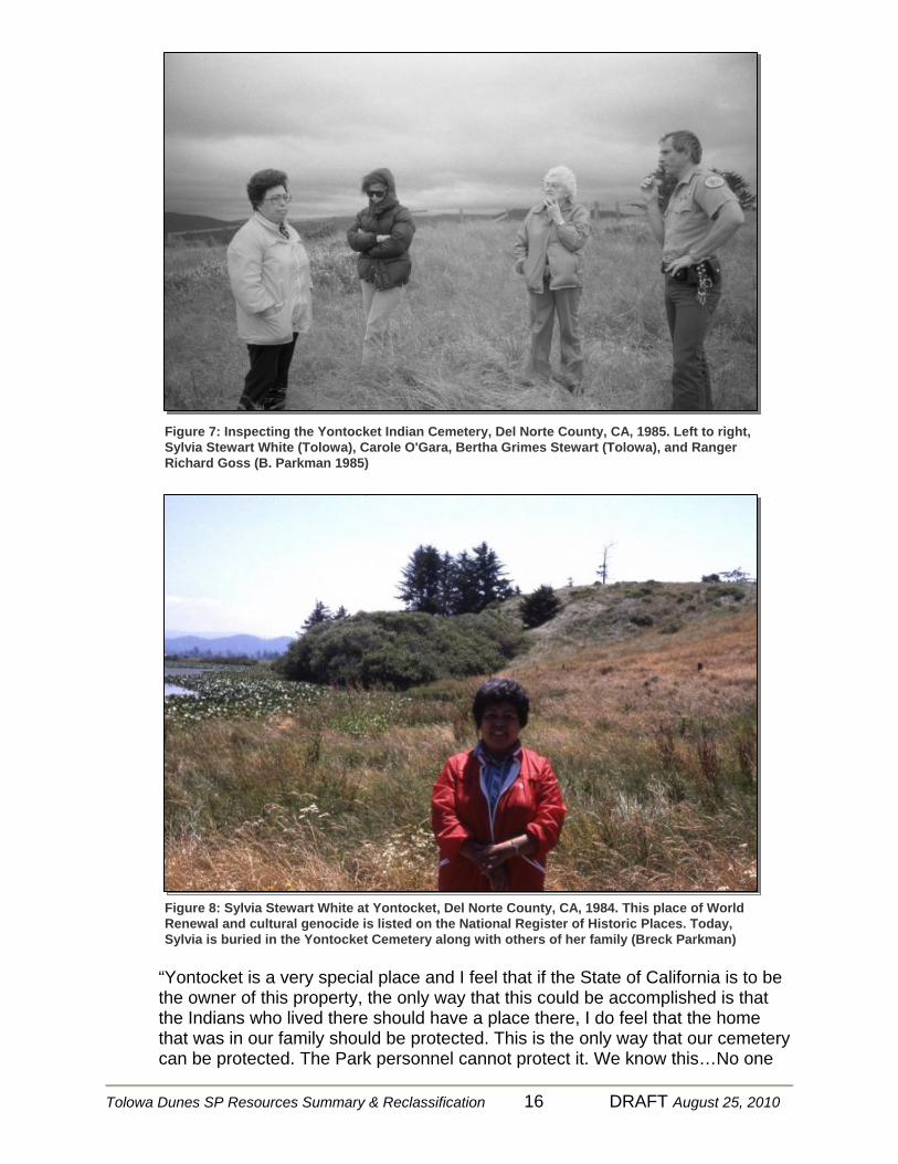
Figure 7: Inspecting the Yontocket Indian Cemetery, Del Norte County, CA, 1985. Left to right, Sylvia Stewart White (Tolowa), Carole O'Gara, Bertha Grimes Stewart (Tolowa), and Ranger Richard Goss (B. Parkman 1985)
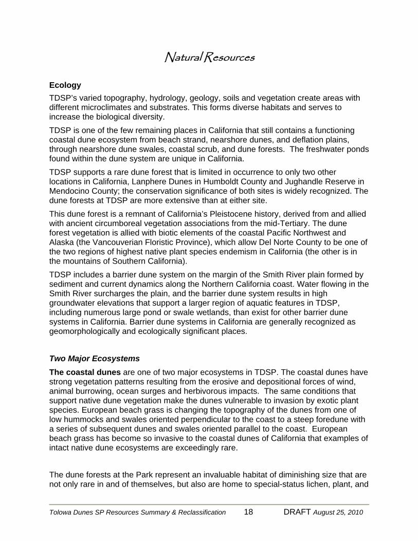
Figure 8: Sylvia Stewart White at Yontocket, Del Norte County, CA, 1984. This place of World Renewal and cultural genocide is listed on the National Register of Historic Places. Today, Sylvia is buried in the Yontocket Cemetery along with others of her family (Breck Parkman)

Tolowa Dunes SP Resources Summary & Reclassification 17 DRAFT August 25, 2010
will appreciate Yontocket like I do and my family. I have always loved Yontocket, going and picking berries with my grandmother, doing summersaults down the sandhills, going in the boat with her and picking lily seeds (wocus), going to the Smith River with her in the afternoon, swimming, rowing the boat while she trolled for salmon, watching my uncle spear flounder in the river…” (White 1984)
Tolowa Dunes SP Resources Summary & Reclassification 18 DRAFT August 25, 2010
Natural Resources Ecology TDSP’s varied topography, hydrology, geology, soils and vegetation create areas with different microclimates and substrates. This forms diverse habitats and serves to increase the biological diversity. TDSP is one of the few remaining places in California that still contains a functioning coastal dune ecosystem from beach strand, nearshore dunes, and deflation plains, through nearshore dune swales, coastal scrub, and dune forests. The freshwater ponds found within the dune system are unique in California. TDSP supports a rare dune forest that is limited in occurrence to only two other locations in California, Lanphere Dunes in Humboldt County and Jughandle Reserve in Mendocino County; the conservation significance of both sites is widely recognized. The dune forests at TDSP are more extensive than at either site. This dune forest is a remnant of California’s Pleistocene history, derived from and allied with ancient circumboreal vegetation associations from the mid-Tertiary. The dune forest vegetation is allied with biotic elements of the coastal Pacific Northwest and Alaska (the Vancouverian Floristic Province), which allow Del Norte County to be one of the two regions of highest native plant species endemism in California (the other is in the mountains of Southern California). TDSP includes a barrier dune system on the margin of the Smith River plain formed by sediment and current dynamics along the Northern California coast. Water flowing in the Smith River surcharges the plain, and the barrier dune system results in high groundwater elevations that support a larger region of aquatic features in TDSP, including numerous large pond or swale wetlands, than exist for other barrier dune systems in California. Barrier dune systems in California are generally recognized as geomorphologically and ecologically significant places.
Two Major Ecosystems The coastal dunes are one of two major ecosystems in TDSP. The coastal dunes have strong vegetation patterns resulting from the erosive and depositional forces of wind, animal burrowing, ocean surges and herbivorous impacts. The same conditions that support native dune vegetation make the dunes vulnerable to invasion by exotic plant species. European beach grass is changing the topography of the dunes from one of low hummocks and swales oriented perpendicular to the coast to a steep foredune with a series of subsequent dunes and swales oriented parallel to the coast. European beach grass has become so invasive to the coastal dunes of California that examples of intact native dune ecosystems are exceedingly rare. The dune forests at the Park represent an invaluable habitat of diminishing size that are not only rare in and of themselves, but also are home to special-status lichen, plant, and
Tolowa Dunes SP Resources Summary & Reclassification 19 DRAFT August 25, 2010
animal species. Rich in abundance, these areas provide wildlife much needed refuge from the harsh elements of the dunes (Mad River Biologists 2009). The forests and inland woodlands contain habitat elements important to wildlife, including snags, down logs and multiple canopy layers. Snags and large trees provide sites for cavity nesting places. Down logs and woody debris are particularly important for reptile, amphibians, and mammals. The multi-layered canopy provides a diversity of nesting and foraging areas.
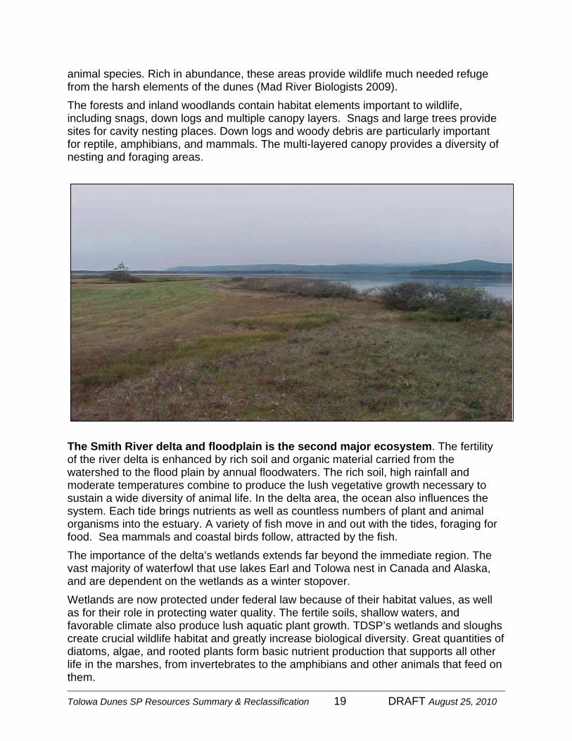
The Smith River delta and floodplain is the second major ecosystem. The fertility of the river delta is enhanced by rich soil and organic material carried from the watershed to the flood plain by annual floodwaters. The rich soil, high rainfall and moderate temperatures combine to produce the lush vegetative growth necessary to sustain a wide diversity of animal life. In the delta area, the ocean also influences the system. Each tide brings nutrients as well as countless numbers of plant and animal organisms into the estuary. A variety of fish move in and out with the tides, foraging for food. Sea mammals and coastal birds follow, attracted by the fish. The importance of the delta’s wetlands extends far beyond the immediate region. The vast majority of waterfowl that use lakes Earl and Tolowa nest in Canada and Alaska, and are dependent on the wetlands as a winter stopover. Wetlands are now protected under federal law because of their habitat values, as well as for their role in protecting water quality. The fertile soils, shallow waters, and favorable climate also produce lush aquatic plant growth. TDSP’s wetlands and sloughs create crucial wildlife habitat and greatly increase biological diversity. Great quantities of diatoms, algae, and rooted plants form basic nutrient production that supports all other life in the marshes, from invertebrates to the amphibians and other animals that feed on them.
Tolowa Dunes SP Resources Summary & Reclassification 20 DRAFT August 25, 2010
Topography TDSP is dominated by a dune system created in part by the mouth of the Smith River. The dunes present at the Park were formed by two episodes of dune movement, involving an older, stabilized system that is partially buried by the currently active dunes (Cooper 1967). These systems occupy a lowland area along the coast that extends inland as much as two miles from the ocean. Much of the center portion of TDSP is bordered by the Lake Earl/Lake Tolowa lagoon complex. North of the lagoons the east side of TDSP is primarily agricultural pastures. In this portion, Yontocket Slough flows in from the east and connects to the Smith River to the north. Climate Like the rest of the California coast, the Del Norte County coast experiences a Mediterranean climate: cool and wet in winter, mostly dry in summer. Below‐freezing temperatures occur on a few days during most winters. Snow is rare. Storms originating in the Gulf of Alaska or the subtropical North Pacific bathe the area with 60 to 80 inches of rain per year, mostly from October through April. Fog‐drip from trees locally augments measured precipitation. Temperatures are moderated by the nearby Pacific Ocean through coastal upwelling and hot inland temperatures that bring in the marine layer (coastal fogs), which are frequent in summer. Conversely, the proximity of the ocean ‐ which absorbs heat in summer and reradiates it in winter ‐ generally precludes extreme cold. Hydrology The flood plain of the Smith River, in addition to the delta, extends southerly to include lakes Earl and Tolowa and surrounding lowlands. Excluding periodic floods from the Smith River, lakes Earl and Tolowa primarily receive water from local drainages to the east and from other ground water sources. Both lakes are shallow with a mean depth of only 5 feet. Within TDSP, permanent water flows include the Smith River and Sweetwater Creek. A relatively high water table exists throughout TDSP for most of the year. Seasonal water flows occur just east of the foredunes and flow mostly to the south. Isolated ponds and marshes impound water within the dunes depending on available ground water and rainfall levels.

Tolowa Dunes SP Resources Summary & Reclassification 21 DRAFT August 25, 2010
Geology Twenty-five million years ago, the TDSP area, now known as the Smith River Plain, was part of the Coastal Range Mountains. Through geologic processes, this portion of the mountain range separated and sank into the ocean. For more than twenty-four million years, the Smith River deposited its alluvium over this block. The alluvium deposits were eventually contoured into a flat submarine plateau by wave action and ocean currents. In the late Pleistocene, the entire plateau tilted landward forming a wave cut platform, which continued to accumulate the sediments of the Smith River. By the end of the Pleistocene, uplift or sea level retreat had exposed parts of the platform with the mouth of the Smith River located where Lake Earl is today. In recent times, the Smith River has migrated to the north. Many of the old channel configurations are still in evidence, the youngest of which is probably Yontocket Slough. Today, lakes Earl and Tolowa are separated from the ocean by a long, wave-built, smoothly beached sand reef with associated dunes. Factors contributing to the formation of the sand reef and dunes include the predominant southward littoral ocean drift, northwesterly winds, abundant sand brought, in part, by the Smith River, and the receptive orientation of the shoreline. Sand dunes run the entire length of the TDSP, forming a very narrow sand spit in the north, becoming wide and flat in the vicinity of Lake Earl, and narrowing again in the south. The dune system consists of older, stabilized dunes that are partially buried by more recent active dunes. Recent aerial photography shows clear evidence of a newly deposited sand sheet north of Pala Road. Most of the dunes within TDSP have become stabilized, and may be reforming, due to the rapid spread of exotic beach grasses.
Soils Soils within TDSP have been mapped and characterized by the United States Soil Conservation Service. The soils range from very well developed loams, to very young soils with little development. Tolowa fine sandy loam soil occurs on the slightly uplifted marine terrace with elevations ranging between 25 and 50 feet above sea level. This soil has minimum profile development, is dark brown in color and is well drained. Texture varies from fine sandy loam to loam with some clay. Presently, grassland and pasture are the predominant land covers found on these soils.

Tolowa Dunes SP Resources Summary & Reclassification 22 DRAFT August 25, 2010
Timmons soil has developed from the medium textured alluvium typically formed from sedimentary rock. This well drained soil has high levels of quartz and some clay. In TDSP, Timmons soils are found on predominately flat terraces, with elevations ranging from 10 to 30 feet above sea level. Coniferous forests are typically associated with this soil. Grasses and forbs mostly stabilize the sand dunes within TDSP, with some willows in low-lying wet sand areas. Shore pine and Sitka spruce are found in drier locations. The older dunes exhibit very little pedogenic development. Particle size analysis indicates these dunes contain a high percentage of fine and very fine sand. This indicates that the dune soils are likely to be deficient in nutrients, especially in nitrogen and phosphorus. Available water for plant growth may be seasonally low, depending on the height of the area above the water table (Mad River Biologists 2009).
Area Description An irregular mosaic of habitats occurs throughout the TDSP. A patchwork of successional stages in the dune habitats allows a diversity of species to occur there. These stages are present due to such agents as wind, animal burrowing, herbivory, and wave surges (Pickart and Sawyer 1998). The natural resources and area descriptions are largely through the efforts of Mad River Biologists 2009. A complete biological resource description of TDSP is available by reading the 2009 Tolowa Dunes Ecological Assessment, Mad River Biologist 2009* (Pages 5-57). The resource description is organized by their position in the overall dune morphology. They contain a brief description of the characteristics of the habitat and a discussion of the plants occurring in the habitat, especially those of special concern. This is followed by a discussion of the animals that may be present in the habitat. Lists of all plant and animal species observed in the field during Mad River Biologist’s study are in Appendices A and B of their report. Status and habitat requirements of all special‐status species present or with potential to occur in the area can be found in their reports. Beach strand or open sand dunes are located within the tidal inundation zone, west of the foredunes. This area consists of loosely compacted sand. Winds, waves, and cyclic tidal inundation restrict plant growth. During the summer months, persistent onshore breezes and moderate wave action causes sand to move onshore. In winter, heavy surf, helped by the absence of the northerly onshore breeze, erodes sand, removes vegetation, and creates a steep foredune, especially in areas vegetated with European beach grass. A diverse assortment of water birds, such as pelicans, gulls, and shorebirds, are common along the beach, especially during the migration periods for those species. Positioned above the mean high tide line is the foredune, a ridge of sand parallel with the beach. It has resulted from sand accumulation around sand tolerant plants (Pickart and Sawyer 1998). The high and steep foredunes at TDSP are attributed to the invasion by European beach grass. The European beach grass has also displaced native beach grass and low growing herbaceous vegetation, known as “dune mat” (Pickart and Barbour 2007).

Tolowa Dunes SP Resources Summary & Reclassification 23 DRAFT August 25, 2010
TDSP contains a nearshore deflation plain, a weathered, basin of unvegetated sand that forms in the wake of moving dunes and in which swales may come together. During storms, deflation plains become seasonally inundated by a rising water table. The emphemeral pools created in these areas are used by a wide variety of wildlife, including ducks, shorebirds, herons, egrets, and river otters. TDSP has nearshore swales, which occur in the comparatively stable dune hollows, or troughs, lying between dune ridges in the nearshore dunes. This area is seasonally flooded by a rising water table and can support herbaceous and woody dune swale vegetation (Pickart and Sawyer 1998). Over time, the dunes at TDSP will be colonized by woody species and become stabilized back dunes, forming coastal scrub and dune forests . This results in a pattern of low wooded ridges interspersed with unforested openings. Plant species common in the dune forest include shore pine, Sitka spruce, grand fir, and rattlesnake plantain. Shore pines tend to be early successional species among the conifers, and are eventually overtopped by both spruces and firs. Advancing dunes overcome and kill pines on their windblown slopes. Spruces and firs standing in close proximity to the pine snags give some wind protection, causing these dune forests to support many snags. Located in depressions within the stabilized dunes, numerous large ponds surrounded by forest contain year‐round standing water. These ponds provide habitat to many aquatic flora and fauna. Crescent Pond is the only open pond. All other ponds are surrounded by shrubs and trees. The most dramatic of the wildlife habitats are the freshwater marshes and associated wetlands. The freshwater marshes are considered Waters of the U.S. and are regulated by the Corps under section 404 of the Federal Clean Water Act. Species include breeding mallards, wood ducks, ringnecked ducks, and, possibly, hooded mergansers. A variety of shorebirds use some of the ponds that have shorelines, and herons, egrets, and American Bitterns hunt the edges, as do swallows and dragonflies. Mammals such as raccoon, beaver, and northern river otter, frequent the ponds, while amphibians such as the northern red‐legged frog depend on them for breeding and foraging. The ponds are among the few sites where western pond turtles are found coastally. The area being considered for reclassification includes Crescent Pond. Historically, the lands east of the dune system were seasonally inundated. These areas have been diked and the land drained in order to create agriculturally productive land. Most of these lands are now grazed by cattle. The vegetation is composed largely of exotic grass species. These areas consist of uplands and persistent freshwater wetlands that are seasonally saturated. A small portion of TDSP is managed for agriculture, and have been dramatically altered from their historical state. Before the introduction of exotic pasture grasses, these areas supported Sitka spruce forests and native coastal prairies. Wetlands were inundated and/or saturated for large portions of the growing season and vegetated by native herbs, sedges, rushes, and grasses. In addition to colonizing the agricultural lands, exotic grasses have spread into the dune ecosystem and are often found invading areas of dune mat, wetlands, and forest. Reed canary grass is an aggressive invasive that was introduced for grazing and now dominates slough channels and meadows at the northern end of the Park along Pala Road and in the Yontocket Slough. Introduced

Tolowa Dunes SP Resources Summary & Reclassification 24 DRAFT August 25, 2010
exotic grasses have changed the species composition of the dunes, as they displace native dune mat plants. They also have changed the morphology of the dunes by reducing wind erosion, as they produce denser vegetal cover than native grasses. This leads, in turn, to the stabilization of dunes that were once mobile. The Area of Consideration includes these agricultural lands and seasonal wetlands including wetlands at Yontocket Slough. TDSP is remarkable not only for its biological richness, but for the opportunities afforded to recreationists. This is a well‐used equestrian venue, and it is also frequented by hikers, nature photographers, and natural Historians and a small number of waterfowl hunters. The near‐absence of human sounds and litter to be experienced in the Park are rarely encountered elsewhere in California’s coastal state parks. It is a natural, scenic, and sensory heritage to be understood, respected, and protected (Mad River Biologists). *This report is used by Park management and resource specialists for resource management and protection at TDSP.
Tolowa Dunes SP Resources Summary & Reclassification 25 DRAFT August 25, 2010
POTENTIAL CLASSIFICATION
Discussion and Analysis Appropriate classifications for this unit were identified and an analysis was undertaken to determine the most suitable classification. Classification categories are described in Division 5, Chapter 1, Article 1.7, Sections 5019.50- 5019.80 of the California Public Resources Code, as follows: State Park Public Resources Code - 5019.53. State parks consist of relatively spacious areas of outstanding scenic or natural character, oftentimes also containing significant historical, archaeological, ecological, geological, or other similar values. The purpose of state parks shall be to preserve outstanding natural, scenic, and cultural values, indigenous aquatic and terrestrial fauna and flora, and the most significant examples of ecological regions of California, such as the Sierra Nevada, northeast volcanic, great valley, coastal strip, Klamath-Siskiyou Mountains, southwest mountains and valleys, redwoods, foothills and low coastal mountains, and desert and desert mountains. Each state park shall be managed as a composite whole in order to restore, protect, and maintain its native environmental complexes to the extent compatible with the primary purpose for which the park was established. Improvements undertaken within state parks shall be for the purpose of making the areas available for public enjoyment and education in a manner consistent with the preservation of natural, scenic, cultural, and ecological values for present and future generations. Improvements may be undertaken to provide for recreational activities including, but not limited to, camping, picnicking, sightseeing, nature study, hiking, and horseback riding, so long as those improvements involve no major modification of lands, forests, or waters. Improvements that do not directly enhance the public's enjoyment of the natural, scenic, cultural, or ecological values of the resource, which are attractions in themselves, or which are otherwise available to the public within a reasonable distance outside the park, shall not be undertaken within state parks. State parks may be established in the terrestrial or nonmarine aquatic (lake or stream) environments of the state.

Tolowa Dunes SP Resources Summary & Reclassification 26 DRAFT August 25, 2010
State Recreation Area Public Resources Code - 5019.56 (a) State recreation areas, consisting of areas selected and developed to provide multiple recreational opportunities to meet other than purely local needs. The areas shall be selected for their having terrain capable of withstanding extensive human impact and for their proximity to large population centers, major routes of travel, or proven recreational resources such as manmade or natural bodies of water. Areas containing ecological, geological, scenic, or cultural resources of significant value shall be preserved within state wildernesses, state reserves, state parks, or natural or cultural preserves, or, for those areas situated seaward of the mean high tide line, shall be designated state marine reserves, state marine parks, state marine conservation areas, or state marine cultural preservation areas. Improvements may be undertaken to provide for recreational activities, including, but not limited to, camping, picnicking, swimming, hiking, bicycling, horseback riding, boating, waterskiing, diving, winter sports, fishing, and hunting. Improvements to provide for urban or indoor formalized recreational activities shall not be undertaken within state recreation areas.
Subclassifications The Public Resources Code also allows for areas within a classified unit of the State Park System to be sub classified as a Natural or Cultural Preserve. The management intent for these sub classifications is to provide for further preservation and protection of the significant natural and cultural resources. In preserves, visitor services and improvements are secondary to resource protection, and overnight use is nonexistent. Areas identified for sub classification require that an approved boundary be defined for Park and Recreation Commission approval.
Natural Preserve (sub-classification)
Public Resources Code - 5019.71. Natural preserves consist of distinct nonmarine areas of outstanding natural or scientific significance established within the boundaries of other state park system units. The purpose of natural preserves shall be to preserve such features as rare or endangered plant and animal species and their supporting ecosystems, representative examples of plant or animal communities existing in California prior to the impact of civilization, geological features illustrative of geological processes, significant fossil occurrences or geological features of cultural or economic interest, or topographic features illustrative of representative or unique biogeographical patterns. Areas set aside as natural preserves shall be of sufficient size to allow, where possible, the natural dynamics of ecological interaction to continue without interference, and to provide, in all cases, a practicable management unit. Habitat manipulation shall be permitted only in those areas found by scientific analysis to require manipulation to preserve the species or associations that constitute the basis for the establishment of
Tolowa Dunes SP Resources Summary & Reclassification 27 DRAFT August 25, 2010
the natural preserve.
Cultural Preserve (sub-classification)
Public Resources Code - 5019.74. Cultural preserves consist of distinct nonmarine areas of outstanding cultural interest established within the boundaries of other state park system units for the purpose of protecting such features as sites, buildings, or zones which represent significant places or events in the flow of human experience in California. Areas set aside as cultural preserves shall be large enough to provide for the effective protection of the prime cultural resources from potentially damaging influences, and to permit the effective management and interpretation of the resources. Within cultural preserves, complete integrity of the cultural resources shall be sought, and no structures or improvements that conflict with that integrity shall be permitted.
Area of Consideration State Recreation Area Classification
The Area of Consideration for the potential SRA is indentified along the state park’s eastern boundary with vehicle access from Lower Lake Road off Pala Road at the north end and just south of Silva Road at the southern end. The western boundary of the Area of Consideration is depicted on the map at Appendix A. This open space area includes seasonal ponds, slough and wetlands habitat that supported waterfowl hunting for much of the past 30 years. The actual SRA boundary will be determined based on public input and further evaluation of factors such as potential conflicts between hunters and other park visitors and protection of resource values, among others. With this change in classification, the natural and cultural resources in this area would continue to be managed for their protection and the preservation of important resource values.
PROPOSED NAMES
Alternative Names Considered Alternative unit names considered for the proposed SRA, along with the Department’s recommendation, will be included in the final document to the Commission. Unit names should reflect the geographic location or place names people associated with this area.
Tolowa Dunes SP Resources Summary & Reclassification 28 DRAFT August 25, 2010
SELECTED REFERENCES Natural Resources
Chad Roberts. 2010. Findings and Recommendations, Tolowa Dunes State Park Dune Forest Ponds. Mad River Biologists. Revised Jan. 15, 2009. Tolowa Dunes Ecological Assessment.
California Department of Parks and Recreation. 2001, Lakes Earl and Tolowa Project Resource Summary Recommendation to Name and Classify. Pickart, A.J. and J.O. Sawyer.1988. Ecology and Restoration of Northern California Coastal Dunes. California Native Plant Society, Sacramento, CA. Cultural Resources Bledsoe, A.J. 1881 History of Del Norte County, California, with a Business Directory and Traveler’s Guide. Humboldt Times Print, Wyman and Co. Publishers, Eureka. Bommelyn, Loren n.d. Smith River Rancheria Tolowa De-ni’ History. Manuscript for revised Tolowa Language Dictionary. Courtesy of author. Burns, Jennifer 2009 et al, DPR 523 site records DN) 19,247,XX3,CRF-YON-01,02,03 Chase, Don n.d. Notes for Del Norte Co. Historical Society: Subject Yontocket, or Burnt Ranch. Copy located in “Yontocket” file, Del Norte County Historical Society, Crescent City. Drucker, Philip 1937 The Tolowa and their Southwest Oregon Kin. University of California Publications in American Archaeology and Ethnology, 36(4):221-300. Berkeley. Eidsness, Janet P. 2002 Tolowa Cultural Sites at Lakes Earl and Talawa in Del Norte County, California. Report prepared for the Smith River Rancheria, Smith River California, and the Elk Valley Rancheria, Crescent City. Fredrickson, D.A. 1984 The North Coast Region. In California Archaeology, edited by M.J. Moratto, pp. 471- 527. Academic Press, New York.

Tolowa Dunes SP Resources Summary & Reclassification 29 DRAFT August 25, 2010
Gould, Richard 1966a Archaeology of the Point St. George Site and Tolowa Prehistory. University of California Publications in Anthropology 4. Berkeley. 1966b Indian and White Versions of “The Burnt Ranch Massacre”: A Study in Comparative Ethnohistory, Journal of the Folklore Institute III. 1975 Ecology and Adaptive Response Among the Tolowa Indians of Northwest California. Journal of California Anthropology 2:148-170 1978 Tolowa. In Handbook of North American Indians: California, Volume 8, edited by Robert F. Heizer, pp. 128-136. Smithsonian Institution, Washington, D.C. Hampson, R. Paul 1973 Nomination Forms, Point St. George Historic District. On file at Yurok Tribal Historic Preservation Office, Klamath.
Hildebrandt, W.R. and J.F. Hayes 1993 Settlement Pattern Change in the Mountains of Northwest California: A View from Pilot Ridge. In There Grows a Green Tree: Papers in Honor of David A. Fredrickson, edited by G.White, P. Mikkelsen,. W.R. Hildebrandt, and M.E. Basgall, pp.107-120. Center for Archaeological Research at Davis Publication no. 11 University of California, Davis.
Hildebrandt, W.R. and V.A. Levulett 1997 Middle Holocene Adaptations on the Northern California Coast: Terrestrial Resource Productivity and Its Influence on the Use of Marine Foods. In Archaeology of the California Coast During the Middle Holocene, edited J.M. Erlandson and T.L. Jones, pp. 303-319. Costen Institute of Archaeology, University of California, Los Angeles. Hood, Joe and John Kelly 1980 Supplemental Site Record for CA-DNO-19. On file at Yurok Tribal Historic Preservation Office, Klamath. Jones, Terry and Klar, Kathryn A. 2007 California Prehistory: Colonization, Culture, and Complexity. Altamira Press
Lanham ,MD
King, Thomas F. and William E. Pritchard 1973 Nomination Forms, Yontocket Historical District. On file at Yurok Tribal Historic Preservation Office, Klamath. Kroeber, A.L. 1925 Handbook of the Indians of California. Bureau of American Ethnology, Bulletin 78. Smithsonian Institution, Washington, D.C.
Tolowa Dunes SP Resources Summary & Reclassification 30 DRAFT August 25, 2010
1962 The Nature of Land-Holding Groups in Aboriginal California. In Aboriginal California: Three Studies in Culture History, pp. 81-120. Archaeological Research Facility, University of California, Berkeley. Parkman, Breck 1984 An Archaeological Evaluation of the Yontocket Village Site (CA-DNO-19), Lakes Earl and Tolowa Project. On file at the California Department of Parks and Recreation, Sacramento. 2006 “An Interview with Bertha Grimes Stewart Regarding Yontocket (CA-DNO- 19/H), the Center of the Tolowa World.” Science Notes Number 37. California State Parks, Diablo Vista District, Petaluma, California.
Tushingham, Shannon 2006 Management Plan of Cultural Resources Located in Tolowa Dunes State Park On file at North Coast District, California State Parks, Eureka, CA. 2008 et al, Archaeological Test Excavations and Sensitivity Assessment for Jedediah Smith Campground, Redwood National and State Parks Del Norte County, California. Van Kirk, Susie 2009 Yontocket Ranch, Del Norte County. On file at North Coast District, California State Parks, Eureka, CA. Waterman, Thomas Talbot 1925 The Village Sites in Tolowa and Neighboring Areas in Northwestern California. American Anthropologist, 27(4):528-543. White, Sylvia Stewart 1984 Letter to Breck Parkman, California State Parks. On file at California State Parks DPR, Sacramento. Recreation Resources 2001 Lakes Earl and Tolowa Project, Resource Summary

Tolowa Dunes SP Resources Summary & Reclassification 31 DRAFT August 25, 2010
APPENDIX A

Tolowa Dunes SP Resources Summary & Reclassification 32 DRAFT August 25, 2010
APPENDIX B
State Park and Recreation Commission STATEMENTS OF POLICY
POLICY II.2
CLASSIFICATION AND NAMING UNITS, FEATURES, GROVES, AND TRAILS OF THE STATE PARK SYSTEM
(Amended 5-4-94) The following procedure will be used to identify, classify, and name units of the State Park System: 1. Unit Project Name
A unit project name may be used by the Department of Parks and Recreation throughout the initial phase of site selection, planning, and acquisition of a unit to be added to the State Park System. The project name, so far as possible, will be based on the criteria outlined in Paragraph 3 below.
2. Classification and Naming
a. Following the acquisition of and preparation of a resource inventory for a new unit of the State Park System, the Department will provide the secretary of the Commission with a recommendation containing the unit's permanent name and classification.
b. The type of classification shall be governed by existing State law, principally the Public Resources Code, Division 5, Chapter 1, Article 1.7, Section 5019.53, et seq.
c. With regard to naming, the Department's recommendation will be based on the criteria outlined in Paragraph 3 below and any existing State regulations.
d. Upon receiving a recommendation for the classification and naming of a unit of the State
Park System, the secretary of the Commission will select the time and place for holding a public hearing before the Commission for this specific purpose. The secretary will ensure that the hearing is properly announced in accordance with existing State regulations in order that the classification and naming as adopted by the Commission may be recorded and made a part of Title 14 of the California Code of Regulations.
3. State Park System Unit Names
In most cases, a unit should bear the name to which it has been accustomed due to location, association, history, natural features, or general usage. Changing the name of a classified unit is strongly discouraged. A unit may be named by the Commission in honor of a person living or deceased, or a group, organization, or other entity which has rendered services of statewide significance to the State Park System.
4. Naming of Features Within Units of the State Park System
The Director may approve the use of a name to identify a feature within a unit of the State Park

Tolowa Dunes SP Resources Summary & Reclassification 33 DRAFT August 25, 2010
System when this action is necessary or desirable for any reason, such as ease in identifying a feature for users of the system, preparation of maps, recognition of deserving individuals or groups, organizations or other entities. Names so selected may be altered or changed by the Director as conditions warrant. The approval of a map or the use of a sign identifying a feature shall constitute the Director's approval and the recording of the Director's actions.
5. Memorial Groves
The Commission reserves the privilege of approving the selection and names given to memorial groves within the State Park System. Sections or areas within units of the State Park System may be permanently set aside as memorial groves for any reason approved by the Commission. However, generally, memorial groves will be approved and named only to honor individuals or organizations who have donated at least $5,000 or one-half of the present market value of the area to be named. Memorial plaques approved by the Department shall be used to identify such areas. These plaques shall include a statement of the State's participation in the acquisition of the grove if appropriate. Memorial groves will be indicated on an official map left in the headquarters of the unit concerned and in the archives of the Commission. The naming of a memorial grove will not have any effect on the area, section, or unit name of a unit of the State Park System.
6. Memorial Trails
The Commission reserves the privilege of approving the selection and names given to memorial trails within the State Park System. Areas within units of the State Park System may be permanently set aside as memorial trails for any reason approved by the Commission. However, generally, memorial trails will be approved and named only to honor individuals or organizations who have donated at least $5,000 or comparable service for trail improvements. Memorial plaques approved by the Department shall be used to identify such areas. These plaques shall include a statement of the State's participation in the establishment of the trail if appropriate. Memorial trails will be indicated on an official map in the headquarters of the unit concerned and in the archives of the Commission. The naming of a memorial trail will not have any effect on the area, section, or unit name of a unit of the State Park System.