tolko/bcts/wfn okanagan operationstolko.com/system/resources... · environmental, economic and...
TRANSCRIPT

Tolko/BCTS/WFN Okanagan Operations
Sustainable Forest Management Plan
April 1, 2016 to March 31, 2017


Tolko/BCTS/WFN Okanagan SFM Plan – 2016/17
Table of Contents
VISION STATEMENT................................................................................................... I EXECUTIVE SUMMARY .............................................................................................1 1.0 INTRODUCTION AND OVERVIEW ......................................................................3 2.0 THE PLAN AREA..................................................................................................5 3.0 THE PLANNING PROCESS................................................................................11 4.0 VALUES AND OBJECTIVES..............................................................................17 5.0 INDICATORS AND INDICATOR MATRICES .....................................................23 6.0 LINKS TO OTHER PLANNING PROCESSES AND POLICIES.........................83 GLOSSARY OF TERMS ...........................................................................................95 APPENDIX 1: DEFINED FOREST AREA MAP .....................................................101 APPENDIX 2: INFORMATION FOR FUTURE CONSIDERATION.........................105 APPENDIX 3: SFM PLAN REPORTING FORMAT ................................................107 APPENDIX 4: SUMMARY OF VALUES, OBJECTIVES INDICATORS
AND TARGETS................................................................................123 APPENDIX 5: OKANAGAN-SHUSWAP LAND AND RESOURCE MANAGEMENT
PLAN................................................................................................139 APPENDIX 6: ADVISORY GROUP TERMS OF REFERENCE..............................149 APPENDIX 7: WEBSITE LINKS TO GOVERNMENT PLANS AND PROCESSES
THAT SUPPORT THE OKANAGAN SFM PLAN ...........................155

Tolko/BCTS/WFN Okanagan SFM Plan – 2016/17

Tolko/BCTS/WFN Okanagan SFM Plan – 2016/17 Page i
Vision Statement
The Tolko, B.C. Timber Sales and Westbank First Nation’s Okanagan
Sustainable Forest Management Plan will foster forest management
practices based on science, professional experience and local public and
First Nations input that contribute to the long-term health and productivity
of forest ecosystems and related forest economies.

Tolko/BCTS/WFN Okanagan SFM Plan – 2016/17

Tolko/BCTS/WFN Okanagan SFM Plan – 2016/17 Page 1
Executive Summary The Sustainable Forest Management (SFM) process was initiated in the Okanagan TSA in May 2000. The public, including First Nations, were invited to participate in the development of a sustainable forest management plan that included indicators and targets that would measure performance. The Public Advisory Group (PAG) that was established included individuals with backgrounds related to recreation, ranching, forestry, conservation, water and community. Over the next 10 years, the application of the sustainable forest management plan changed as other forest organizations elected to become part of the SFM process. As a result, PAG membership changed from public members being mostly concentrated in the south Okanagan (where the Plan was first applied), to that where membership includes those residing in the north Okanagan and Shuswap area. Currently, Tolko, BC Timber Sales, and the Westbank First Nation are the forest organizations participating in the SFM Process. The SFM Plan includes a set of values, objectives, indicators and targets that address environmental, economic and social aspects of forest management in Tolko’s, BCTS and WFN’s (the Licensees) primary operating areas in the Okanagan, as well as Tolko’s operating areas in the Arrow and Boundary Forest District. The plan area also includes block specific areas that fall outside of the primary plan area. The SFM Plan is based on the Canadian Standards Association (CSA) Sustainable Forest Management Standard (CAN/CSA Z809) one of the primary certification systems currently being used in British Columbia and Canada. The CSA system sets performance objectives and targets over a defined forest area to reflect local and regional interests. Consistent with most certifications, the CSA standards require compliance with existing forest policies, laws and regulations. The SFM Plan is an evolving document that will be reviewed and revised on an annual basis with the SFM Advisory Group to address changes in forest condition and local community values. Each year the SFM Advisory Group reviews an annual report prepared by the Licensees, to assess achievement of performance measures. This monitoring process provides the Licensees, public and First Nations with an opportunity to bring forward new information and provide input concerning new or changing public values that can be incorporated into future updates of the SFM Plan. Current information on the SFM Plan and process can be viewed on the website:
http://thompsonokanagansustainableforestry.ca/okanagan_top.htm

Tolko/BCTS/WFN Okanagan SFM Plan – 2016/17 Page 2

Tolko/BCTS/WFN Okanagan SFM Plan – 2016/17 Page 3
1.0 Introduction and Overview For more than a decade, there has been an increasing worldwide demand for “certified” wood products. This has led to the development of a number of certification systems to provide assurance to consumers that forest products have been produced using environmentally and socially responsible forest practices. The Canadian Standards Association (CSA) Sustainable Forest Management Standard (CAN/CSA Z809); is one of the primary forest certification programs currently being used in British Columbia and Canada. The CSA system requires the development of performance objectives and targets over a defined forest area to reflect local and regional interests. The process of CSA certification includes advisory committees composed of a range of public, stakeholders with specified interests and First Nations. Tolko Industries Ltd., B.C. Timber Sales (BCTS) and Westbank First Nation (WFN) are the participating entities in the Okanagan Sustainable Forest Management Plan. These organizations are commonly referred to in the plan as the “participating Licensees” or “Licensees”. Of note is the absence of Gorman Bros. – who decided in 2013 not to continue with CSA certification and participation in the SFM Plan. The other licencees thank Gorman’s for their contribution to the continual improvement of the Plan over the years. The Licensees, with advice from the SFM Public Advisory Group, have used the CSA certification system as the basis to develop the Okanagan Sustainable Forest Management (SFM) Plan. This Plan provides management direction for all of Tolko’s operating areas in the Okanagan-Shuswap Forest District and Arrow Boundary Forest District, and for BCTS and WFN operating areas within the Okanagan-Shuswap Forest District. The Licensees have been consulting with the public to develop responsible forest management plans for over 25 years. Many planning processes, including those for Forest Stewardship Plans, provide for public and First Nations review and comment. The Licensees prepare Forest Stewardship Plans that incorporate the direction provided through these various planning processes. Licensee standards and operating plans are continuously updated as new information comes forward. The SFM Plan is one component of the Licensees’ commitment to adapt their management practices in response to changes in societal values. This Sustainable Forest Management Plan is a “roadmap” to current and future strategies related to long-term performance. The values, objectives, indicators and targets described in this document were developed with advice from the SFM Advisory Group. The Licensees adherence to these values, objectives, indicators and targets will support sustainable forest management within their respective operating areas. The SFM Plan is an evolving document that will be reviewed and revised on an annual basis with the SFM Advisory Group to address changes in forest conditions and local community values.

Tolko/BCTS/WFN Okanagan SFM Plan – 2016/17 Page 4
More information about the Okanagan certification process, Sustainable Forest Management planning, meeting summaries, annual reporting and maps can be obtained at the Okanagan Certification website: http://thompsonokanagansustainableforestry.ca/okanagan_top.htm

Tolko/BCTS/WFN Okanagan SFM Plan – 2016/17 Page 5
2.0 The Plan Area The Defined Forest Area (DFA) for Tolko’s Okanagan Regional Woodlands is located in the Okanagan Shuswap and Arrow Boundary Forest Districts. For BCTS-Okanagan Columbia Business Area and WFN, the Defined Forest Area is located within the Okanagan Shuswap Forest district. The boundary of the DFA is specified in the Licensees’ geographic information system (GIS) inventory. A map of the area, depicting the Licensees primary operating areas, is shown in Appendix 1. In order to generate a legible map for the SFM Plan, land ownership status is incomplete. It should be noted that private land, federal land, and other reserves are not part of the DFA. Licensees have access to more detailed mapping that can identify ownership should there be an interest in looking at a refined map area of the DFA. The Plan area and the statistics that follow were revised in 2013 to reflect Gorman Bros.’s election not to participate in the Plan, updated inventory information from the latest Timber supply Review and the recent adjustments to the operating areas of participating licencees. The DFA includes Tolko’s traditional operating areas in the Okanagan and Arrow TSA's including TFL 49, FL’s A18632, A18667, A18672, A20191, and A74912, and Timber Licence T0816. Tolko manages FL A18632 on behalf of the Licensee, Selkirk Timber Company. A portion of Bell Pole Company Ltd’s FL A18666, which is also managed by Tolko, is included in the DFA. Additional tenures that would be included in the DFA are as specified in Tolko’s Forest Stewardship Plan. There are also a number of cutblocks within and outside Tolko’s operating area that have been previously harvested under various tenures, and for which Tolko still has silvicultural liability. These blocks will be included in the reporting for indicators related to silvicultural activities.
The DFA for WFN includes their Community Forest Agreement K1P, FLA91134 and their Woodlot Licence W0346. These replaceable licenses give the Licensees the authority to harvest trees and construct roads along with the responsibility for forest planning, reforestation and road maintenance. The DFA also includes approximately 25 BCTS operating areas scattered across the Okanagan Timber Supply Area, ranging in size from a few hundred hectares to several thousand hectares. In addition to the listed licences, there may be other licences that operate within the DFA through such mechanisms as Non-Replaceable Forest Licences or transfers through Section 18 of the Cut Control Regulation. Activity on these licences may occur inside the Licensees primary operating areas or outside the primary areas. Annual reporting will occur for these licences where they are under the control of the Licensees or where the Ministry of Forests, Lands and Natural Resource Operations has included the requirement for reporting in the licence document. The successful bidders are encouraged to participate in both the SFM process and meetings. Tenure specific reporting requirements are included in the appendices of each tenure document. Reporting data for blocks outside the primary operating area will be cutblock specific. Thus inventory reporting information for the DFA will be restricted to the primary operating areas only, however for reporting of block specific targets (such as area in permanent access structures) reporting will be for the entire DFA (activities within primary operating areas and block specific activities outside the primary area). Table 1 illustrates the distribution of land classes within the DFA. Nearly 40 percent of the DFA (including parks, inoperable areas, and non-productive areas) is not available for harvesting.

Section 3.0 – The Planning Process
Tolko/BCTS/WFN Okanagan SFM Plan – 2016/17 Page 6
However, these areas are included in the DFA as they play a role in biodiversity and landscape level ecosystem functions. Table 1: DFA Allocation for Tolko, BCTS and WFN (area in hectares)
Land Classification Westbank Tolko BCTS Total Area Percent of Total
Area
Streams, wetlands, lakes 32 7,621 1,863 9,516 1% Non Forest Land (alpine, rock, open range) 407 38,130 11,725 50,262 5% Non-contributing forest (deciduous, problem forest type, ESAs, inoperable, NP, NPBR) 12,814 117,915 53,628 184,357 18% Forest set aside for other values (parks, protected areas, old growth areas, riparian, wildlife tree reserves, etc). 8,932 101,656 38,231 148,819 14% Timber Harvesting Land Base 36,691 430,780 173,471 640,942 62% Total Defined Forest Area 58,876 696,102 278,918 1,033,896 100%
The Crown land portion of the DFA proposed for harvesting and related development must be referred to the public, and approved by the appropriate government agencies. All activities must be consistent with government regulations, as well as relevant regional and sub-regional planning directions. The Licensees incorporate any applicable regulation, direction and information into their Forest Stewardship Plans, which are available to the public for comment. In the case of development occurring under an approved FSP, individual cutblocks will only be referred to those stakeholders who have expressed an interest at the FSP stage, or where the Licensee is aware of there being public interest in the proposed development.
Figure 5 in the 2011 Okanagan TSA Timber Supply Analysis Public Discussion Paper (refer to Appendix 7 for access to the website link - page 10 of the Discussion Paper) illustrates the transition from existing natural stands to managed stands is expected to occur approximately 55 years from now.
Section 3.0 – The Planning Process
Tolko/BCTS/WFN Okanagan SFM Plan – 2016/17 Page 7
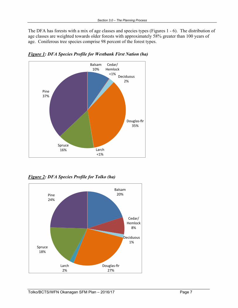
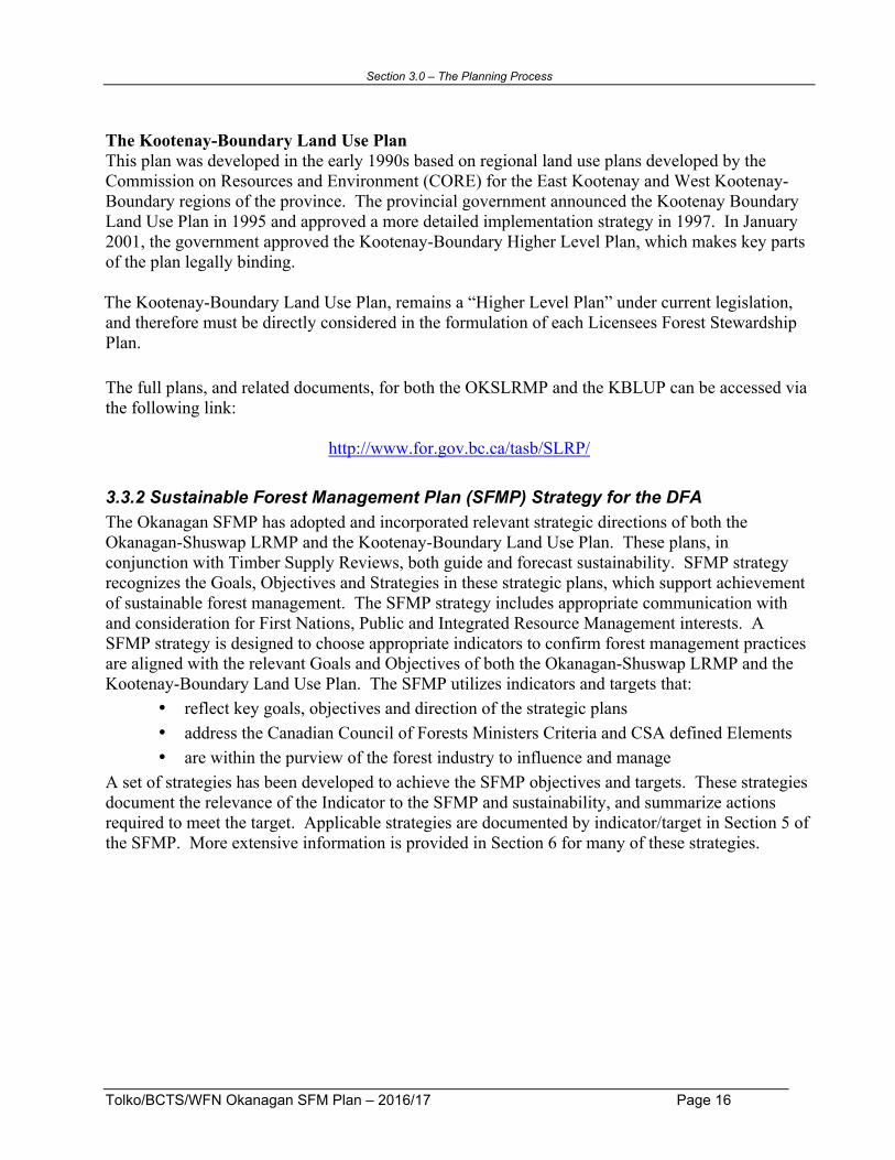
The DFA has forests with a mix of age classes and species types (Figures 1 - 6). The distribution of age classes are weighted towards older forests with approximately 58% greater than 100 years of age. Coniferous tree species comprise 98 percent of the forest types. Figure 1: DFA Species Profile for Westbank First Nation (ha)
Figure 2: DFA Species Profile for Tolko (ha)
Balsam10%
Cedar/Hemlock<1%
Deciduous2%
Douglas-fir35%
Larch<1%
Spruce16%
Pine37%
Balsam20%
Cedar/Hemlock
8%
Deciduous1%
Douglas-fir27%
Larch2%
Spruce18%
Pine24%

Section 3.0 – The Planning Process
Tolko/BCTS/WFN Okanagan SFM Plan – 2016/17 Page 8
Figure 3: DFA Species Profile for BC Timber Sales (ha)
Figure 4: DFA Species Profile for Tolko, BCTS and WFN combined (ha)
Balsam15%
Cedar/Hemlock
7%
Deciduous1%
Douglas-fir28%
Larch4%
Spruce14%
Pine31%
Balsam18%
Cedar/Hemlock7%
Deciduous2%
Douglas-fir28%
Larch2%
Spruce16%
Pine27%
DFASeciesProfile

Section 3.0 – The Planning Process
Tolko/BCTS/WFN Okanagan SFM Plan – 2016/17 Page 9
Figure 5: DFA Forest Age Class Distribution
Figure 6: DFA Forest Greater than 100 Years of Age
0
20,000
40,000
60,000
80,000
100,000
120,000
140,000
160,000
180,000
200,000
1-20 21-40 41-60 61-80 81-100 101-120 121-140 141-250 250+
1 2 3 4 5 6 7 8 9
Area(ha)
Age/AgeClass
BCTS
Tolko
WFN
42%lessthan100years
58%greaterthan100years
DFAForestAge


Tolko/BCTS/WFN Okanagan SFM Plan – 2016/17 Page 11
3.0 The Planning Process 3.1 The CSA Certification Process The CSA Sustainable Forest Management (SFM) Standard initially developed in 1996 and subsequently revised and improved in 2002 and again in 2009 is Canada’s national certification standard. The standard is a voluntary tool that provides independent third party assurance that an organization is practicing sustainable forest management. Consistent with most certifications, the CSA standard requires compliance with existing forest policies, laws and regulations.1 Participants under the CSA certification system must address the following two components: 1. Participants must develop and achieve performance measures for on-the-ground forest
management, monitored through an annual public review with input from the public and First Nations (Sec 3.1.1 following); and
2. Participants who choose to be registered to the CSA standard must internally
incorporate CSA-defined systems components that emphasize an appropriate environmental management system (Sec 3.1.2 following).
Applicants seeking registration to the CSA standard require an accredited, independent third-party auditor to verify that these components have been adequately addressed. Following registration, annual surveillance audits are conducted by each company to confirm that the standard is being maintained. A detailed description of these two components is as follows.
3.1.1 Public involvement: performance requirements and measures The CSA standard includes performance requirements for assessing sustainable forest management practices that influence on-the-ground forestry operations. The performance requirements are founded upon six sustainable forest management criteria: 1. Conservation of biological diversity; 2. Maintenance and enhancement of forest ecosystem condition and productivity; 3. Conservation of soil and water resources; 4. Forest ecosystem contributions to global ecological cycles; 5. Multiple benefits to society; and 6. Accepting society’s responsibility for sustainable development. Each criterion has a number of “elements” that further define the intent. The criteria and associated elements are all defined under the CSA standards and must be addressed during development of the SFM Plan. The criteria are endorsed by the Canadian Council of Forest Ministers and are aligned with international criteria. New to the CSA Standard in 2010 (Z809-08 version) was the need to have specific discussion on selected forest management topics during the public participation process. Also new was the requirement for the SFM Plan to contain core indicators for nearly all of the elements.
1 This includes compliance with relevant strategic directions provided in the Okanagan-Shuswap Land and Resource Management Plan and Kootenay Boundary Land Use Plan.

Section 3.0 – The Planning Process
Tolko/BCTS/WFN Okanagan SFM Plan – 2016/17 Page 12
For each set of criteria and elements, forest managers, and the Public Advisory Group, must identify local values and objectives. Indicators and targets are assigned to the values and objectives to measure performance.
Discussion Items identified in the CSA Z809 Standard for each of the six SFM criteria have been reviewed and discussed as needed by the Public Advisory Group in conjunction with the development of this SFM Plan. Detailed information on the topics can be found in the meeting summaries and reference material associated with the development of this Plan. Values identify the key aspects of the elements. For example, one of the values associated with “species diversity” might be “sustainable populations of native flora and fauna” Objectives describe the desired future condition, given an identified value. For example, the objective to meet the value of sustainable populations of native flora and fauna might be “to maintain a variety of habitats for naturally occurring species.” Indicators are measures to assess progress toward an objective. Indicators are intended to provide a practical, cost-effective, scientifically sound basis for monitoring and assessing implementation of the SFM Plan. There must be at least one indicator for each element and associated value. Core indicators have been included in the CSA standard for nearly all elements. Additionally, local indicators can be added to the SFM Plan. Targets are specific short-term (one or two year) commitments to achieve identified objectives. Targets provide a clear, specific statement of expected results, usually stated as some level of achievement of the associated indicator. For example, if the indicator is “reduction in area of the timber harvesting landbase”, a target might be “to have less than x percent of harvested areas in roads and landings.”
Values, objectives, indicators, and targets apply to socioeconomic and ecological criteria and may address process as well as on-the-ground forest management activities. As part of the process of developing values, objectives, indicators and targets, the SFM Advisory Group also assisted in the development of forecasts of predicted results for indicators and targets.
Forecasts are the long-term projection of expected future indicator levels. These have been incorporated into the SFM Plan targets as predicted results or outcomes for each target. Forecasting is further described in Section 5.

Section 3.0 – The Planning Process
Tolko/BCTS/WFN Okanagan SFM Plan – 2016/17 Page 13
Audits and Public Review Each year the participating Licensees compile a report that summarizes results for each of the performance measures (see Appendix 3: SFM Plan reporting format). This annual report is provided to the SFM Advisory Group for review and comment. Annual monitoring of the achievement of the Plan and comparison of the actual results to forecasts enables the effectiveness of the SFM Plan to be continually improved, in keeping with CSA standards. The achievement of performance measures (indicators and targets) is assessed annually through surveillance audits carried out by a registered third party auditor. The audits will determine whether the registrant has successfully implemented the SFM Plan and continues to meet the CSA Standard. Audit summaries are available to the public. A summary of the third-party audits can be found on the SFM website. SFM Monitoring Report summaries for each licencee may also include a synopsis of the management reviews, where required by each company under the SFM standard. The CSA SFM system includes a number of processes or systems-related requirements called “systems components” as follows: • Commitment: A demonstrated commitment to developing and implementing the SFM Plan. • Public participation: The CSA standards require informed, inclusive, and fair consultation with
the Advisory Group during the development and implementation of the SFM Plan. • CSA-aligned management system: The management system is an integral part of the
implementation of the SFM Plan and is designed to meet CSA standards. The management system has four basic elements: 1) Planning; 2) Implementing; 3) Checking and Monitoring; and 4) Review and Improvement. Each of the Licensees management systems have the following base components:
1. Identify environmental risks. 2. Identify standard operating procedures or develop performance measures to address
significant risks. 3. Develop emergency procedures in the event of an incident causing environmental impacts. 4. Review all laws and regulations. 5. Establish procedures for training. (Providing updated information and training ensures that
forestry staff and contractors stay current with evolving forest management information and are trained to address environmental issues during forestry activities.)
6. If an incident does occur, conduct an investigation or incident review and develop an action plan to take corrective action, based on the preparation undertaken in steps 1 – 5.
• Continual improvement: within the context of the management system, monitoring and
reviewing the system and its components continually improve the effectiveness of the SFM Plan. This includes a review of ongoing planning, and public process to ensure that the management system is being implemented as effectively as possible.

Section 3.0 – The Planning Process
Tolko/BCTS/WFN Okanagan SFM Plan – 2016/17 Page 14
3.2 The Okanagan SFM Planning Process The initial SFM Plan was developed by Licensees based on advice and recommendations provided by the SFM Advisory Group. The Plan was developed to be in compliance with all existing legislation and policy and consistent with the strategic direction and intent of the Okanagan-Shuswap LRMP and the Kootenay-Boundary Land Use Plan. The Licensees participate in the maintenance and continual improvement of the plan. The participating Licensees recognize the legal rights of other resource users on the common land base and have considered these rights in the formulation of this plan and related field operations.
3.2.1 Public Participation The SFM Advisory Group was formed to assist the participating Licensees in developing and maintaining the SFM Plan by identifying local values, objectives, indicators and targets and evaluating the effectiveness of the Plan. Members of the SFM Advisory Group represent a cross-section of local interests including environmental organizations, forest workers, fish and wildlife, agriculture, and research specialists. An open and inclusive process was used to establish the Public Advisory Group. Local First Nations, TFL 15 advisory table members and other interested community members were formally invited to participate. Periodic reviews of the membership have been made with the objective of seeking participants from underrepresented sectors. The Ministry of Forests, Lands and Natural Resource Operations and the Ministry of Environment provide technical support to the SFM planning process including information and advice on land and resource and policy issues. The SFM Advisory Group developed, and is guided by, a terms of reference and procedures consistent with the CSA standard. Specified in the Terms of Reference and Procedures is that the process for developing the SFM Plan will be open and transparent. A copy of the current ToR is available on the website: http://thompsonokanagansustainableforestry.ca/okanagan_top.htm Potential indicators and targets suggested by the SFM Advisory Group that have not been incorporated into the SFM Plan because of either a lack of data or a means to measure the indicator are included in Appendix 2 and will be considered as part of the continual improvement process during subsequent reviews of the plan. The SFM Plan is an evolving document that will be reviewed and revised on an annual basis with the SFM Advisory Group to address changes in forest condition and local community values. Each year the SFM Advisory Group will review an annual report prepared by the Licensees to assess achievement of performance measures. This monitoring report process provides the public and First Nations with an opportunity to bring forward new information and to provide input concerning new or changing public values that can be incorporated into future updates of the SFM Plan.
3.2.2 Government and First Nations Participation Government agencies participate in the SFM planning process in two roles: 1) as a forest Licensee, and 2) to provide technical support to the planning process (see section 3.2.1). The Ministry of Environment also participated in the development of the initial Plan in a resource/support capacity. First Nations were involved in the 2009 revisions to the Plan to meet the new CSA standards, in particular in the development of the new indicator’s.

Section 3.0 – The Planning Process
Tolko/BCTS/WFN Okanagan SFM Plan – 2016/17 Page 15
First Nations have chosen to limit their participation in the process, but were kept advised throughout the SFM Plan development and implementation. Increased Government agency and First Nations participation in the maintenance of the SFM Plan would lead to a stronger and more inclusive plan. To reflect the addition of BCTS and its Okanagan operating areas, BCTS distributed invitations to eleven First Nations, two tribal councils, and eleven forest resource stakeholders.
3.3 Strategy Guiding the SFM Plan
3.3.1 Okanagan - Shuswap Land & Resource Management Plan &
Kootenay Boundary Land Use Plan The Okanagan - Shuswap Land & Resource Management Plan (LRMP) and the Kootenay Boundary Land Use Plan (KBLUP) have provided broad strategic direction for the sustainable management of land and resources. These plans were developed with extensive public input and public participation. The Okanagan-Shuswap LRMP This plan received approval in principle by the LRMP Table in January of 2001 and became a cabinet-approved strategic land use plan shortly thereafter. However, in recent years maintenance of the plan has not been a priority and the unmaintained plan has become progressively less relevant as other planning processes have supplanted it. The Okanagan-Shuswap LRMP is no longer a supported planning process; however, many of the goals and objectives that were included in the plan have been incorporated into a variety of government planning directives and subsequently incorporated into Licensee Forest Stewardship Plans. Government has embarked on a process to declare parts of the OSLRMP as a higher-level plan using “land use objectives” and “orders under the Government Actions Regulation” (GAR) under FRPA. Licensees are legally obligated to incorporate results and strategies in their Forest Stewardship Plans that meet the objectives set by government under the Forest and Range Practices Act. In some cases the Targets and Indicators in this SFMP specifically refer to baseline data, studies, planning zones, etc that were developed in creation of LRMP; these have been retained where appropriate. In this, the 2012 edition of the Okanagan-Shuswap Sustainable Forest Management Plan, most of the references to the OSLRMP have been removed. The exceptions being those reference which have been retained to provide historical perspective, or where the reference is found within the SFMP Target or Indicator itself. In such cases, changes should be reviewed and approved by the Public Advisory Group of the SFMP at future meetings. For a more detailed history of the Okanagan-Shuswap LRMP please refer to Appendix 5 of this document. As a matter of interest, the full plan can be accessed on line via the website link at the bottom of section 3.3.3.
Section 3.0 – The Planning Process
Tolko/BCTS/WFN Okanagan SFM Plan – 2016/17 Page 16
The Kootenay-Boundary Land Use Plan This plan was developed in the early 1990s based on regional land use plans developed by the Commission on Resources and Environment (CORE) for the East Kootenay and West Kootenay-Boundary regions of the province. The provincial government announced the Kootenay Boundary Land Use Plan in 1995 and approved a more detailed implementation strategy in 1997. In January 2001, the government approved the Kootenay-Boundary Higher Level Plan, which makes key parts of the plan legally binding. The Kootenay-Boundary Land Use Plan, remains a “Higher Level Plan” under current legislation, and therefore must be directly considered in the formulation of each Licensees Forest Stewardship Plan. The full plans, and related documents, for both the OKSLRMP and the KBLUP can be accessed via the following link:
http://www.for.gov.bc.ca/tasb/SLRP/ 3.3.2 Sustainable Forest Management Plan (SFMP) Strategy for the DFA The Okanagan SFMP has adopted and incorporated relevant strategic directions of both the Okanagan-Shuswap LRMP and the Kootenay-Boundary Land Use Plan. These plans, in conjunction with Timber Supply Reviews, both guide and forecast sustainability. SFMP strategy recognizes the Goals, Objectives and Strategies in these strategic plans, which support achievement of sustainable forest management. The SFMP strategy includes appropriate communication with and consideration for First Nations, Public and Integrated Resource Management interests. A SFMP strategy is designed to choose appropriate indicators to confirm forest management practices are aligned with the relevant Goals and Objectives of both the Okanagan-Shuswap LRMP and the Kootenay-Boundary Land Use Plan. The SFMP utilizes indicators and targets that:
• reflect key goals, objectives and direction of the strategic plans • address the Canadian Council of Forests Ministers Criteria and CSA defined Elements • are within the purview of the forest industry to influence and manage
A set of strategies has been developed to achieve the SFMP objectives and targets. These strategies document the relevance of the Indicator to the SFMP and sustainability, and summarize actions required to meet the target. Applicable strategies are documented by indicator/target in Section 5 of the SFMP. More extensive information is provided in Section 6 for many of these strategies.

Tolko/BCTS/WFN Okanagan SFM Plan – 2016/17 Page 17
4.0 Values and Objectives The following local values and objectives were identified by the SFM Advisory Group to address each of the criteria2 and associated elements prescribed by the CSA standards. A number of indicators and associated targets have been developed to meet these local values and objectives. SFM Plan indicators and targets are described in Section 6. A summary table showing all criteria and elements and associated local values, objectives, and indicators is provided in Appendix 4.
Criterion 1: Conservation of Biological Diversity Conserve biological diversity by maintaining integrity, function, and diversity of living organisms and the complexes of which they are part.
Element 1.1: Ecosystem Diversity Conserve ecosystem diversity at the stand and landscape levels by maintaining the variety of communities and ecosystems that naturally occur in the DFA.
• Healthy, productive, well-balanced ecosystem
• Well functioning, ecologically diverse ecosystem
• Abundance of connected and productive habitat (i.e. distribution across the landscape)
• Maintenance of a full range of seral stage distribution
• Maintain full range of habitat • Retention of vertical structure for stand
level attributes
1.1.1, 1.1.2, 1.1.3, 1.1.4, 1.1.5
Element 1.2: Species Diversity Conserve species diversity by ensuring that habitats for the native species found in the DFA are maintained through time including habitats for known occurrences of species at risk. • Sustainable populations of flora
and fauna native to the DFA (including subspecies) and the abundance and distribution of species within their natural range of variation
• Species native to the DFA are maintained at sustainable levels
1.2.1, 1.2.2, 1.2.3
2 It should be noted that the in Criterion 6 , the phrase “society’s responsibility for sustainable development” was
interpreted by the SFM Advisory Group to mean “society’s concerns and interests with respect to sustainable development”.

Section 4.0 – Values and Objectives
Tolko/BCTS/WFN Okanagan SFM Plan – 2016/17 Page 18
Element 1.3: Genetic Diversity Conserve genetic diversity by maintaining the variation of genes within species and ensuring that reforestation programs are free of genetically modified organisms.
• Diversity of genetic material within species
• Adaptability to change • Sustainable populations of flora
and fauna native to the DFA (including subspecies) and the abundance and distribution of species within their natural range of variation
• Maintain genetic diversity of all species (and subspecies) native to the DFA
1.3.1, 1.3.2, 1.3.3
Element 1.4: Protected Areas and Sites of Special Biological Significance Respect protected areas identified through government processes. Co-operate in broader landscape management related to protected areas and sites of special biological and cultural significance. Identify sites of special geological, biological, or cultural significance within the DFA, and implement management strategies appropriate to their long-term maintenance.
• Natural functioning ecosystems • Rare physical environments
• Maintenance of representative natural, and known rare, functioning ecosystems
1.4.1, 1.4.2
Criterion 2: Maintenance and Enhancement of Forest Ecosystem Condition and Productivity Conserve forest ecosystem condition and productivity by maintaining the health, vitality, and rates of biological production.
Element 2.1: Forest Ecosystem Resilience Conserve ecosystem resilience by maintaining both ecosystem processes and ecosystem conditions.
• Resilient forest ecosystems • Forest management does not compromise ecosystem resilience
2.1.1
Element 2.2: Forest Ecosystem Productivity Conserve forest ecosystem productivity and productive capacity by maintaining ecosystem conditions that are capable of supporting naturally occurring species. Reforest promptly and use tree species ecologically suited to the site.
• Well-functioning, biologically productive forest ecosystems
• Forest ecosystems that support naturally occurring species.
2.2.1, 2.2.2

Section 4.0 – Values and Objectives
Tolko/BCTS/WFN Okanagan SFM Plan – 2016/17 Page 19
Criterion 3: Conservation of Soil and Water Resources Conserve soil and water resources by maintaining their quantity and quality in forest ecosystems.
Element 3.1: Soil Quality and Quantity Conserve soil resources by maintaining soil quality and quantity.
• Soil health and productivity ! Biological ! Physical
• Minimize physical and biological degradation of soil
3.1.1, 3.1.2
3.2: Water Quality and Quantity Conserve water resources by maintaining water quality and quantity.
• Protection and security of the water resource
• Stream flow regimes that provide levels of water quality and quantity within a natural range of variability
• Retain natural systems that support water quality and quantity
• Protection of quality and quantity of water in licensed domestic watersheds
3.2.1, 3.2.2, 3.2.3, 3.2.5
Criterion 4: Forest Ecosystem Contributions to Global Ecological Cycles Maintain forest conditions and management activities that contribute to the health of global ecological cycles.
Element 4.1: Carbon Uptake and Storage Maintain the processes that take carbon from the atmosphere and store it in forest ecosystems.
• Balanced, well-functioning ecological processes that support healthy, productive forest ecosystems
• Forest management activities are conducted in ways that maintain ecological processes
4.1.1, 2.1.1
Element 4.2: Forest Lands Conversion Protect forestlands from deforestation or conversion to non-forests where ecologically appropriate.
• Protection and security of forest land to ensure health of global ecological cycles
• Maintain healthy, productive forest land base
2.2.1

Section 4.0 – Values and Objectives
Tolko/BCTS/WFN Okanagan SFM Plan – 2016/17 Page 20
Criterion 5: Multiple Benefits to Society Sustain flows of forest benefits for current and future generations by providing multiple goods and services.
Element 5.1: Timber and Non-Timber Benefits Manage the forest sustainably to produce an acceptable and feasible mix of both timber and non-timber benefits. Evaluate timber and non-timber forest products and forest-based services.
• Forests contribute to the quality of life
• Opportunity and access to the forest resource for a variety of commercial and non-commercial uses
5.1.1
Element 5.2: Communities and Sustainability Contribute to the sustainability of communities by providing diverse opportunities to derive benefits from forests and by supporting local community economies.
• Sustained multiple benefits from our forests
• Local public involvement
• Opportunity and access to the forest resource for a variety of commercial and non-commercial uses
• Affected and local interested parties have input into decisions
5.2.1, 5.2.2, 5.2.3, 5.2.4
Criterion 6: Accepting society’s responsibility for sustainable development Society’s responsibility for sustainable forest management requires that fair, equitable, and effective forest management decisions are made.
Element 6.1: Aboriginal and Treaty Rights Recognize and respect Aboriginal title and rights and treaty rights. Understand and comply with current legal requirements related to Aboriginal title and rights and treaty rights. • Respect for Aboriginal title and
rights and treaty rights • Duly established Aboriginal and treaty
rights considered in forest management planning and opportunities provided for meaningful participation by First Nations in forest management and planning
6.1.1, 6.1.2, 6.1.3

Section 4.0 – Values and Objectives
Tolko/BCTS/WFN Okanagan SFM Plan – 2016/17 Page 21
Element 6.2: Respect for Aboriginal Forest Values, Knowledge, and Uses Respect traditional Aboriginal forest values, knowledge and uses as identified through the Aboriginal input process.
• Respect for the special and unique needs of Aboriginal peoples
• Participation by First Nations in forest management and planning to ensure that the special and unique needs of Aboriginal peoples are respected and accommodated in forest management decisions
6.2.1
Element 6.3 Forest Community well-being and resilience Encourage, co-operate with, or help to provide opportunities for economic diversity within the community.
• Economic benefits to society • A prosperous forest industry with sustainable supply of timber and non-timber resources
6.3.1, 6.3.2, 6.3.3
Element 6.4: Fair and Effective Decision-Making Demonstrate that the SFM public participation process is designed and functioning to the satisfaction of the participants and that there is general public awareness of the process and its progress.
• Awareness of what is going on (knowledge/information)
• Ability to influence • Participate in decision making
• Public values are incorporated in decision-making processes and fairly considered in development and maintenance of the SFM Plan
• Implementation of the SFM Plan will influence forest management outcomes
6.4.1, 6.4.2, 6.4.3
Element 6.5: Information for Decision-Making Provide relevant information to interested parties to support their involvement in the public participation process, and increase knowledge of ecosystem processes and human interactions with forest ecosystems.
• Shared knowledge and informed decisions
• Adaptive forest management that is responsive to research, experience and public input
6.5.1, 6.5.2

Section 5.0 – Indicators and Indicator Matrices
Tolko/BCTS/WFN Okanagan SFM Plan – 2016/17 Page 22

Section 5.0 – Indicators and Indicator Matrices
Tolko/BCTS/WFN Okanagan SFM Plan – 2016/17 Page 23
5.0 Indicators and Indicator Matrices In a SFM Plan it is the indicators and targets that provide the performance measures that are to be met through on-the-ground forest management activities. This section provides a detailed description of each of the indicators and targets in the SFM Plan. Core indicators prescribed within the latest CSA standard (Z809-08) have been integrated into the Plan using the numbering system found within the standard. Full compliance is required for most targets (i.e., there is no variance). Where full compliance may not be achievable, an acceptable level of variance is indicated for the target. Participating Licensees monitor the achievement of targets annually. Management strategies, forecasting and current status provides further direction to the performance measures (indicators and targets) and will serve as a guide in annual monitoring activities. The format the Licensees use to complete annual reporting is shown in Appendix 3.
Non-Replaceable Forest Licenses (NRFL’s) and Small Scale Salvage Licensees holding NRFL’s have a limited ability to influence achievement of Targets for some of the SFM Plan Indicators and will report against Targets where they do influence. Where participating licencees are partners in or are managing a NRFL, they will be reported by that licencee. At minimum these NRFL's will report performance against targets 2 to 7, 9, 11 to 22, 24, 25, 27, 29, 31 and 36. The activities occurring within the Ministries' Small Scale Salvage program will not be reported on due to the relatively small size of the program (60,000m3 or approximately 2% of the volume reported in the 2011/12 SFM Monitoring Report).
Additional Guidance The Licensees are guided by the regulations, laws and policies established by the federal, provincial, and municipal governments. Licensees are obligated to incorporate results and strategies in their Forest Stewardship Plans that meet the objectives set by government under the Forest and Range Practices Act. Public participation and input into forest operations is a key component of the participating Licensee’s social license to operate on Crown land. The Licensees have policies to help control and regulate their performance and guide its direction relative to environmental and forest management. The direction in legislation and corporate policies (noted above) guide the Licensee’s strategies for managing its forest operations to provide high quality fiber over the long term. At the same time, legislation and Licensee policies help to manage and balance the landscape for biological diversity, global cycles, soil, water and social responsibility. The Okanagan Sustainable Forest Management Plan public participation process has helped to further refine information and clarify concerns of the local public. Incorporating these concerns and ideas into the Licensee’s operations through the established performance measures and ongoing monitoring will ensure long-term sustainability of the forest resource. Any indicators established in this Sustainable Forest Management Plan that are conducive to long term projections are as noted below. Section 6.4 describes the plans, policies and management strategies that support the achievement of the targets in the SFM Plan.

Section 5.0 – Indicators and Indicator Matrices
Tolko/BCTS/WFN Okanagan SFM Plan – 2016/17 Page 24
Forecasting Predicting the results of forest management indicators and targets for the Defined Forest Area assists in evaluating determining their effectiveness. Forecasts are projections of expected future indicator levels. Forecasts for the indicators agreed upon by the Public Advisory Group have already been incorporated into the SFM Plan targets as predicted results or outcomes for each target. Forecasting of many of the SFM Plan Indicators and Targets has already occurred at the Regional level, and either directly or indirectly at the provincial or regional level. The Okanagan-Shuswap LRMP and Kootenay-Boundary LUP, both developed general targets, and more specific sub-zone targets within their respective plan areas. As appropriate, the SFM Plan has incorporated predicted results or outcomes from these plans for the indicator as part of the target.
Provincial Forecasting Related to the SFM Plan A Provincial Level Timber Supply Analysis of regulatory requirements of the Forest Practices Code occurred in August 2001. The analysis reviewed timber supply impacts of Code requirements related to: riparian management areas, biodiversity at the stand and landscape level, watershed assessment sensitivity, identified wildlife species at risk, soil conservation and visual quality management. The harvest level impact related to biodiversity and riparian management were based on analysis using the BC Forest Service Simulation Model (FSSIM) and impact assessments related to remaining Code requirements were based on professional estimates. The analysis was then completed at both the provincial and regional levels to determine the short-term effects of the legislative requirements.

Section 5.0 – Indicators and Indicator Matrices
Tolko/BCTS/WFN Okanagan SFM Plan – 2016/17 Page 25
Regional Forecasting Related to the SFM Plan Prior to the approval of the Okanagan Shuswap LRMP in January 2001, a multiple accounts analysis was completed which assessed potential social, economic and environmental impacts relative to set of baseline indicators. The analysis assisted the OSLRMP table members in achieving approval in principle for the Plan. In the AAC rationale for the Okanagan TSA, the chief forester determined that a timber harvest level that accommodates objectives for all forest resources can be best achieved by establishing an AAC of 3.1 million m3. In making this determination, the chief forester has considered integrated resource management objectives, social objectives and economic objectives.. The analysis was conducted using a timber supply computer model, information about the timber harvesting landbase, timber volumes and management strategies to project a future state for a period of 250 years. Prior to the Chief Forester making his determination, the public was invited to review and comment on the Timber Supply Review (TSR). Further information on the opportunities for public input and the data used to conduct timber supply analysis can be found on the Ministry of Forests, Lands and Natural Resource Operations website: http://www.for.gov.bc.ca/hts/tsa/tsa22/ - documents The new AAC determination by the Chief Forester was released in March 2012. Any indicators established in this Sustainable Forest Management Plan that are conducive to long term projections are as noted below. The DFA falls within a significant portion of the Okanagan TSA, TFL 49, and only a small portion of the Arrow TSA. All forecasts and strategies apply to the entire DFA and in some cases are based on Timber Supply Reviews. Given the small portion of the Arrow TSA occupied by the DFA, it is not feasible or effective to model or base Arrow TSR level forecasts for this relatively small parcel of land.
Indicators Some indicators/targets are repeated for more than one element – even when indicators/targets are not repeated, this does not imply any limitation of their applicability to other elements. Individual Licensees will determine their staff’s reporting responsibilities for the indicators/targets. Base Line for Indicators The primary source of base line information for indicators is the initial monitoring report subsequent to adoption of the indicator. Where existing indicators and targets were used to satisfy a core indicator, the baseline will be that from the previous SFM Plan. In some instances, particularly in the case of newly developed indicators, a baseline might be difficult to establish and thus be absent in the SFM Plan. In those situations, baseline information will become available through subsequent monitoring reports.

Section 5.0 – Indicators and Indicator Matrices
Tolko/BCTS/WFN Okanagan SFM Plan – 2016/17 Page 26
Current Status Current status of each indicator will be as reported and updated in annual SFM Plan performance reporting. To obtain current information please refer to the most recent monitoring report at the website: http://thompsonokanagansustainableforestry.ca/okanagan_top.htm
Legal Requirements Adherence to federal and provincial laws assists the Licensees in demonstrating sustainable forestry. Compliance with legislation, together with conformance to the SFM Plan Indicators and Targets, leads to the achievement of the SFM Plan’s vision statement. Awareness of legal requirements is essential when considering suitable Objectives for an Element, and determining appropriate Indicators and Targets. In the following Indicator tables applicable Acts and Regulations are noted in the “Legal Requirements” section. Specific Sections/Subsections of these Acts and Regulations have not been identified to avoid having to manage the ongoing changes to forest legislation. Forest Licensees ensure that specific legislation related to Objectives, Indicators and Targets is known and complied with by staying current with legal requirements. Subscribing to commercial services, reliance on in house staff or industry associations and participating in joint legislative review committees are just some of the methods used by Licensees to remain current with legislation

Section 5.0 – Indicators and Indicator Matrices
Tolko/BCTS/WFN Okanagan SFM Plan – 2016/17 Page 27
Guide to Criterion, Elements, Indicators and Targets
Criteria Elements Indicators Targets
1. Conservation of Biological Diversity 1.1 Ecosystem Diversity 1.1.1, 1.1.2 1.1.3, 1.1.4 1.1.5
1, 2, 3, 4, 5, 6, 43
1.2 Species Diversity 1.2.1, 1.2.2 1.2.3
7, 8, 9, 10
1.3 Genetic Diversity 1.3.1, 1.3.2 1.3.3
3, 7, 4
1.4 Protected Areas and sites of Special Biological significance
1.4.1, 1.4.2 7, 3, 11
2.1 Forest ecosystem Resilience
2.1.1 4, 12,13 2. Maintenance and Enhancement of Forest Ecosystem Condition and Productivity
2.2 Forest Ecosystem Productivity
2.2.1, 2.2.2 14, 15
3. Conservation of Soil and Water Resources
3.1 Soil Quality and Quantity 3.1.1, 3.1.2 14, 16, 17, 18, 19
3.2 Water Quality and Quantity
3.2.1, 3.2.2 3.2.3, 3.2.5
20, 21, 22, 24
4. Forest Ecosystem Contribution to Global Ecological Cycles
4.1 Carbon Uptake and Storage
4.1.1, 2.1.1 5, 12, 14, 4, 13
4.2 Forest Lands Conversion 2.2.1 14 5. Multiple Benefits to Society 5.1 Timber and Non Timber
Benefits 5.1.1 15, 26, 11,
24, 27, 28, 29, 30
5.2 Communities and Sustainability
5.2.1, 5.2.2 5.2.3, 5.2.4
15, 26, 31, 32, 33
6. Accepting Society’s Responsibility for Sustainable Development
6.1 Aboriginal and Treaty Rights
6.1.1, 6.1.2 6.1.3
36, 37, 11, 37
6.2 Respect for Aboriginal Forest Values, Knowledge, and Uses
6.2.1 11, 36, 37
6.3 Forest Community Well-being and Resilience
6.3.1, 6.3.2 6.3.3
15, 24, 26, 27, 28, 30, 38, 39
6.4 Fair and Effective Decision-Making
6.4.1, 6.4.2 6.4.3
34, 35, 40, 41, 42, 32, 37
6.5 Information and Decision Making
6.5.1, 6.5.2 29, 41, 42

Section 5.0 – Indicators and Indicator Matrices
Tolko/BCTS/WFN Okanagan SFM Plan – 2016/17 Page 28

Section 5.0 – Indicators and Indicator Matrices
Tolko/BCTS/WFN Okanagan SFM Plan – 2016/17 Page 29
Indicator 1.1.1 Ecosystem Area by Type
Element(s) 1.1 Ecosystem Diversity
Strategy(s) Description
Ecosystem conservation represents a coarse-filter approach to biodiversity conservation. It assumes that by maintaining the structure and diversity of ecosystems, the habitat needs of various species will be provided. For many species, if the habitat is suitable, populations will be maintained. Managers can influence ecosystem area by type, and many foresters/ecologists prefer to characterize the forest in terms of ecosystem types (according to forest ecosystem classifications) rather than by age and type of structures as derived from classic forest inventories. The biogeoclimatic ecosystem classification (BEC) used throughout BC is an integrated hierarchical classification scheme that combines climate, vegetation and site classifications. Within the Defined Forest Area for the SFM Plan, BEC mapping has occurred down to the subzone level (a combination of ecological features, primarily climate and physiography). The broad biogeoclimatic (zonal) units are used in such applications as: a. Seed zones b. Protected area planning c. Land management planning d. Forest pest risk e. Natural disturbance types f. Wildlife habitat management This broad classification is used in combination with detailed site information to derive site series classification—a level that provides operational guidance. Common interpretations for each site series include:
• Most suitable tree species for regeneration • Stocking, stock type, and ‘free-to-grow’ standards for tree species • Vegetation competition after harvesting • Site limiting factors, harvest season and reforestation considerations • Site index by tree species
Biodiversity can be affected by the disruption of natural processes. Future maintenance of biodiversity is in part dependent upon the maintenance and connectivity of representative habitats and seral stages at the landscape and watershed level. Retention of Old Growth Management Areas (OGMA’s) throughout the DFA will assist in providing a supply of late seral habitat. Within the DFA, OGMA placement considered the location of rare ecosystems. It is felt that somewhere around 90% of the mature forested rare ecosystems identified on base maps have been included within OGMA’s. Thus it is important when managing OGMA’s that these rare ecosystems are retained. As only a small amount of mature forested rare ecosystem area is located outside of OGMA’s, there is limited opportunity to replace rare ecosystems inside of OGMA with rare outside.
Means of achieving objective and target
BEC mapping has occurred throughout the TSA to the subzone level. Slight changes to the area and distribution of BEC subzones occurs when new data is collected in poorly sampled areas. Climate change may alter representation, particularly drier sites. The Licensee’s ability to influence change to the area and distribution of BEC subzones is limited. Okanagan-Shuswap LRMP allocated approximately 62,000 ha on the Timber Harvesting Landbase and 124,000 ha on the Non-Timber Harvesting Landbase for Old Growth Management Areas to align with the Provincial biodiversity strategy. These OGMA’s have been identified in the area covered by the OKSLRMP. OGMA's have also been identified in the area covered by the KBLUP The Licensees will be guided by the OSLRMP and KBLUP guidance and will look to find innovative solutions to manage for old forest attributes. There are provisions for Licensees to make changes to OGMA’s, and Changes to specific OGMA’s are managed through the Forest Stewardship Plans of each Licensees have been able to locate the rare ecosystem map coverage used to establish OGMA’s during the LRMP process.
Baseline Data Target 1. Forest Licensees have access to and utilize BEC data to guide their strategic and operational plans. Licensee operations will not contribute to any change in the presence and representativeness of Biogeoclimatic Zones (2008 baseline data). Target 2. Participating licencees currently maintain 74,464.4 hectares of Old Growth Management Area (2014 baseline data). Target 3. There are 5798.2 ha of forested mature rare ecosystems contained within OGMA's. There was a net reduction of 0.5 ha of rare ecosystems within OGMA’s in 2011 and no change to the amount of rare ecosystems in 2012. Target 5. Age classes 2, 3 and 4 each have less than 10 % area representation (2014 baseline data). Age classes 1 to 5 average 8.5% reflecting the disproportionate area in over mature age classes (2014 baseline data).

Section 5.0 – Indicators and Indicator Matrices
Tolko/BCTS/WFN Okanagan SFM Plan – 2016/17 Page 30
Forecast Healthy ecosystems with a diversity and abundance of native species and habitats. The greatest risk to changes in the presence and representativeness of Biogeoclimatic Zones is climate change. The BC Government’s Forest Stewardship Action Plan for Climate Change Adaptation (Feb 2012) http://www.for.gov.bc.ca/ftp/HFP/external/!publish/ClimateChange/Adaptation/MFLNR_CCAdaptation_Action_Plan_2012_final.pdf outlines actions to adjust BC’s existing forest management framework to foster resilient forests, communities and industry. This Action Plan has been built on the work done under the Future Forest Ecosystems Initiative (2005) and will over the next three to five years, provide tools (such as the climate-based seed transfer strategy, new TSA-level silviculture strategies, creation of a “knowledge and tools” website, and other decision support tools that support climate based regeneration decisions) for practitioners to incorporate adaptation to climate change into forest stewardship practices. Analytical forecasting will largely be based on new and emerging policy direction and the framework for which these policies, guidance and tools will be developed. Age class and seral stage distribution of forests are forecast as part of a periodic Timber Supply Review to monitor impacts on the landscape. Okanagan-Shuswap LRMP spatially allocated approximately 62,000 ha on the Timber Harvesting Landbase and 124,000 ha on the Non-Timber Harvesting Landbase for Old Growth Management Areas to align with the Provincial biodiversity strategy. Additionally, 7500 ha is available on the Timber Harvesting Landbase for Identified Wildlife Management Strategy and “interim measures document”. OGMA area within the DFA is slightly more than 119,000 ha. It is expected that in the long-term, 8% of the DFA will be in the Old Seral age-class, and each age-class (to 100 years of age) in the THLB will occupy at least 10% of the landbase. Target 1 for this Indicator is to maintain the number of hectares in landscape level reserves (OGMA’s) thereby ensuring ecosystems representative of specific BEC’s are maintained into the future. Reference: Okanagan Shuswap LRMP Multiple Accounts Analysis – Final Base Case with LRMP Analysis (November 2000)”. The integrity of mapped rare mature forest ecosystems will be retained within OGMA’s. LRMP Analysis3: The plan provides for connectivity in several ways. At the regional level, the importance of maintaining connectivity between the very dry habitats associated with the Okanagan valley to the central interior of the Province was recognized. At the landscape level, the provision of additional protected areas enhances the representation of undisturbed areas. This is augmented by the available OGMA budget, which may be distributed within/across LU's to contribute towards a connectivity objective. At the stand level, the plan provides maintaining functional connectivity by planning for harvested and leave areas that maintain mature/older stands in a connected manner for as long as possible.
Target 1. Maintain the presence and representative area of Biogeoclimatic Zones to the subzone level within the Plan area. 2. Licensee operations will maintain the retention of existing or replacement draft old growth management areas. 3. Licensee operations will maintain the retention of forested mature “rare” ecosystems within old growth management areas (variance for this new target to be set after a few years of monitoring). 5. Progress towards a stable forest age class distribution on the timber harvesting land base where each age class to 100 years old [1 (1 to 20), 2 (21-40), 3 (41-60), 4 (61 to 80) and 5 (81 to 100)] occupies at least 10% of the timber harvesting land base. Three age classes meet this target within 50 years.
Basis for the Target
The province’s ecological classification system is recognized as world class. Utilizing the BEC classification system and mapping was seen to be the best way to report on the indicator. While Licensees have little influence on the presence and representative area of these BEC subzones, the classification system provides tremendous support to both strategic and operational decision making. Provincial Non-spatial Old Growth Order (May 2004) Retention of rare ecosystems within OGMA’s will maintain these areas throughout the DFA.
Legal Requirements
Use of the BEC classification system is inherent in the Forest and Range Practices Act and the Forest Planning and Practices Regulation. Provincial Non-spatial Old Growth Order (May 2004)
Monitoring & Masurement
Periodic
1. Part of periodic Timber Supply Review (TSR) – often used to define of Analysis Units for timber supply modeling. Licensees will report the area for all Biogeoclimatic subzones as updated for the most current TSR’s. Reporting to occur periodically – in the year following completion of subsequent TSR’s and determination of the allowable annual cut (or other known updates to BEC).
Annual 2. Licensees report the total area of draft OGMA’s within their operating area and the area of net OGMA reduction as a result of their operations. 3. Licensees report the total rare ecosystem area within OGMA’s and the reduction of net rare ecosystem area within OGMA’s as a result of their operations. 5. Licensees report the current age class distribution on the DFA for the THLB area.
Variance 3. Target is likely required and will be determined after a few years of monitoring. 5. Age class targets attained 20 years later.
3 Okanagan Shuswap “Land & Resource Management; Multiple Accounts Analysis - Final Base Case with LRMP Analysis”, 2000

Section 5.0 – Indicators and Indicator Matrices
Tolko/BCTS/WFN Okanagan SFM Plan – 2016/17 Page 31
Indicator 1.1.2 Forest Area by type or species composition Element(s) 1.1 Ecosystem Diversity
Strategy(s) Description
Forest area by type is a refinement of the previous indicator – ecosystem area. Tree species composition, stand age, and stand structure are important variables that affect the biological diversity of a forest ecosystem - providing structure and habitat for other organisms. Ensuring a diversity of tree species improves ecosystem resilience and productivity and positively influences forest health. Reporting on this indicator provides information on area covered by forests, forest succession and management practices that might alter species composition.
Means of achieving objective and target
Licensee plans will incorporate strategies that promote multi species regeneration and consider the potential implications of climate change.
Baseline Data Eighty-six percent of the cutblocks declared free growing during the reporting year had three or more tree species. The average of the leading tree species was 64% (2004 baseline data).
Forecast Diversity and abundance of naturally occurring tree species on the landscape. Native species are maintained at endemic and sustainable levels. Analytical forecasting of species composition occurs during each Timber Supply Review and is based on ecologically based regeneration strategies assigned to each Analysis Unit (aggregates of stands with similar characteristics) as outlined in Section 4.4 of the 2010 Okanagan TSA Data Package. http://www.for.gov.bc.ca/hts/tsa/tsa22/index.htm Proportion of leading species on the Crown forested land base and the timber harvesting land base, as of 2011, is referenced on page 5 of the Okanagan TSA Timber Supply Analysis Public Discussion Paper, August 2011. In addition, historical trends from previous monitoring reports illustrate that the target associated with this Indicator is being met consistently thereby placing increased confidence in the forecast. To access data referenced above, refer to Appendices 7 and 10. Species composition information is utilized in the Provincial Timber Supply Review.
Target 4. 70 percent of the area of cutblocks harvested will have three or more tree species (includes conifer and deciduous comprising one percent or more of total trees) in the free growing survey.
Basis for the Target The need to maintain the biological diversity of forest ecosystems in managed second-growth and third-growth forests. Addresses diversity and abundance of naturally occurring tree species on the landscape. OSLRMP guidance.
Legal Requirements Forest and Range Practices Act, Forest Planning and Practices Regulation
Monitoring & Measurement Periodic
Annual To enable reporting, an information system will be used to generate a list of cutblocks that were declared free growing and to track information on the free growing survey (inventory label). A summary will be generated of field survey information, showing tree species present at free growing during the reporting period. The average (in percent) of the leading tree species, for those cutblocks having three or more species, will be identified in the report.
Variance None

Section 5.0 – Indicators and Indicator Matrices
Tolko/BCTS/WFN Okanagan SFM Plan – 2016/17 Page 32
Indicator 1.1.3 Forest area by seral stage or age class
Element(s) 1.1 Ecosystem Diversity
Strategy(s) Description
A balanced age class distribution provides ongoing habitat opportunities for all forest dwellers, some which occupy forests only when specific habitat attributes are present. Often, these attributes are time sensitive. Balanced age classes also allow for a more even flow of timber values and benefits. A reduction of the current imbalance of mature to over mature stands also reduces forest health risks. Forecasted forest age class distribution over time provides an indication of sustainability. Balanced age classes will result in a larger proportion of hectares in younger faster growing stands with a net carbon intake. In addition to the age-class information, Licensees report on the species composition of regenerating forests as they reach “free-growing” status (Target 4). Taken together, these two targets provide a picture of the future forest species composition, age-class breakdown, and inferred ecological conditions.
Means of achieving objective and target
The Okanagan-Shuswap LRMP allocated approximately 62,000 ha on the Timber Harvesting Landbase and 124,000 ha on the Non-Timber Harvesting Landbase for Old Growth Management Areas to align with the Provincial biodiversity strategy. These OGMA’s have been identified in the area covered by the OKSLRMP. OGMA's have also been identified in the area covered by the KBLUP The Licensees are guided by the OSLRMP and KBLUP guidance and will look to find innovative solutions to manage for old forest attributes. There are provisions for Licensees to make changes to OGMA’s, and Changes to specific OGMA’s are managed through the Forest Stewardship Plans of each. Maintain current harvest priority:
Forest health management – harvesting attacked and susceptible stands (generally older stands) “Available” stands with the most years beyond culmination (maximum mean annual increment)
OGMA area within the DFA is slightly more than 119,000 ha.
Baseline Data Target 2. Participating licencees currently maintain 74,464.4 hectares of Old Growth Management Area (2014 baseline data). Target 5. Age classes 2, 3 and 4 each have less than 10 % area representation (2014 baseline data). Age classes 1 to 5 average 8.5% reflecting the disproportionate area in over mature age classes (2014 baseline data).
Forecast Age class and seral stage distribution of forests are forecast as part of a periodic TSR to monitor impacts on the landscape. Okanagan-Shuswap LRMP allocated approximately 62,000 ha on the THLB and 124,000 ha on the Non-THLB for Old Growth Management Areas to align with the Provincial biodiversity strategy. Additionally, 7500 ha is available on the THLB for Identified Wildlife Management Strategy and “interim measures document”. OGMA area within the DFA is slightly more than 119,000 ha. Continuation of current harvest priorities will lead to balanced age classes on the available productive forest land. Protected Area, OGMA’s, and Wildlife Tree Patch Strategies, together with inaccessible areas, ensure retention of sufficient old growth to sustain biodiversity and ecosystem objectives. Progress to target will be steady:
! In 50 years age classes 1 to 5 average 10.6% and three age classes meet target.
Target will be achieved within 100 years. Analytical forecasting of age class distribution occurs during Timber Supply Reviews and is based on expected harvest rates and natural disturbance projections summarized in the 2011 Okanagan TSA Public Discussion Paper. This analysis provides a forecast (page 10 of the Discussion Paper) that provides a timeline for the transition from harvesting natural stands to harvesting managed stands. This transition is expected to occur in approximately 55 years. The SFM Monitoring Report has also been tracking age class distribution for the THLB portion of the DFA for the past several years and is reviewed on an annual basis.
Target 2. Licensee operations will maintain the retention of existing or replacement draft old growth management areas. 5. Progress towards a stable forest age class distribution on the timber harvesting land base where each age class to 100 years old [1 (1 to 20), 2 (21-40), 3 (41-60), 4 (61 to 80) and 5 (81 to 100)] occupies at least 10% of the timber harvesting land base. Three age classes meet this target within 50 years.
Basis for the Target Provincial Non-spatial Old Growth Order (May 2004) Relatively even flow of value to industry and the community
Legal Requirements Forest and Range Practices Act, Forest Planning and Practices Regulation
Monitoring & Measurement Periodic
Current status and future forecast of age class distribution is provided as part of Timber Supply Review completed periodically.

Section 5.0 – Indicators and Indicator Matrices
Tolko/BCTS/WFN Okanagan SFM Plan – 2016/17 Page 33
Annual 2. Licensees report the total area of draft OGMA’s within their operating area and the area of net OGMA reduction as a result of their operations. 5. Licensees report the current age class distribution on the DFA for THLB area.
Variance 5. Age class targets attained 20 years later.

Section 5.0 – Indicators and Indicator Matrices
Tolko/BCTS/WFN Okanagan SFM Plan – 2016/17 Page 34
Indicator 1.1.4 Degree of within-stand structural retention or age class
Element(s) 1.1 Ecosystem Diversity
Strategy(s) Description
Complexity of stand structure is a key component of an operational strategy to sustain biodiversity in forested ecosystems (Bunnell et al 1999). Structural complexity helps to mitigate the potential deleterious effects of large scale stand and landscape simplification associated with intensive short-rotation forest management. It can be provided by the adoption of retention silvicultural systems, a practice broadly applied in interior BC (Lindenmayer and Franklin 2003, Bunnell et al. 1999). Wildlife tree patches (WTP’s) are a retention tool recommended for use in stand and landscape planning to help sustain biodiversity and ecological processes. They are used to provide protection for known wildlife habitat features (including standing dead and dying trees), to provide attributes important to key ecological processes (including woody debris, tree species diversity, and understory vegetation diversity), to protect small, local habitat features (i.e. unclassified riparian or wetlands, rock outcrops or rare plants or ecosystems), or to provide stand level complexity (vertical and horizontal) to harvest areas under even-aged, short rotation management. At the landscape level WTPs can be used with OGMAs to provide landscape structure to help keep landscape complexity more consistent with natural disturbance regimes. Operationally retention of wildlife trees/stubs in cutblocks is subject to worker safety considerations as specified in the WorkSafe BC requirements for wildlife and danger trees. Note that wildlife tree patches may be located outside of cutblocks, along their edge, and still be consistent with provincial policy on wildlife tree retention. Where wildlife tree stubs are left, they should form only one part of the stand level tree retention found on a cutblock.
Means of achieving objective and target
Licensees will achieve targets through allocation of WTP’s/WTRA’s and dispersed retention (individual trees and stubs) during forest development planning. Licensee plans and practices support retention and protection of designated wildlife trees/stubs (e.g. use of no work zones, felling at the silviculture stage where appropriate, etc). Harvest value and ecological value can be optimized by selecting the variety of tree types (e.g., species, size, live and dead, etc.) that have high ecological value and low economic value, and through the number of trees retained. Wildlife trees and tree patches should be favored over stub trees.
Baseline Data 100% of cutblocks harvested (182) each had associated wildlife tree retention (100%). 99% of harvested cutblocks contained at least an average of 2-5 stubs or standing trees per hectare (181/182 cutblocks). 2003 is the year of baseline data for both data sets.
Forecast FREP Report #29, Southern Interior Forest Region: Analysis of Stand-Level Biodiversity Sampling Results in Six Predominant Biogeoclimatic Subzones. Min. For. Lands Nat. Resource. Operations. This report is a preliminary analysis of stand level biodiversity outcomes related to harvesting and tree retention and has been done for several BEC subzones in the Southern Interior. Over 650 cutblocks were assessed for stand-level biodiversity attributes and 91% of these had retention (>0.5% of the cutblock area). Based on this analysis and the Monitoring Report results for the past several years with respect to this target, forecasting of this indicator is expected to result in healthy ecosystems with a diversity and abundance of native species and habitats. Majority of harvested areas (at least 4/5) will have habitat attributes that will help to sustain biodiversity and ecological processes.
Target 6. 100 percent of harvested cutblocks requiring wildlife tree retention (patches and/or individual trees) will be completed in accordance with their Site Plan. 80 percent of harvested areas contain a minimum average of 2-5 stub trees and/or wildlife trees per hectare with consideration given to spatial distribution.
Basis for the Target FSP commitments to manage government objectives for stand level biodiversity. OSLRMP guidance.
Legal Requirements Forest and Range Practices Act, Forest Planning and Practices Regulation, Workers Compensation Act.
Monitoring & Measurement Periodic
Annual To enable reporting, an information system will be used to generate a list of cutblocks where harvesting was completed, those blocks that had WTP requirements, areas where plan commitments related to WTP’s not met as well as a list of cutblocks that contained mature reserve summary data and/or reserve trees and/or reserve stubs. Remaining harvested cutblocks not identified in the information system as having reserve trees or patches associated with the harvest area will be cross referenced with GIS databases, Forest Stewardship Plan or other plans.
Variance None.

Section 5.0 – Indicators and Indicator Matrices
Tolko/BCTS/WFN Okanagan SFM Plan – 2016/17 Page 35
Indicator 1.1.5 Harvest system diversity (Non-core indicator)
Element(s) 1.1 Ecosystem Diversity
Strategy(s) Description
Complexity of stand structure is a key component of an operational strategy to sustain biodiversity in forested ecosystems (Bunnell et al 1999). Structural complexity helps to mitigate the potential deleterious effects of large scale stand and landscape simplification associated with intensive short-rotation forest management. It can be provided by the adoption of retention silvicultural systems, a practice broadly applied in interior BC (Lindenmayer and Franklin 2003, Bunnell et al. 1999). Throughout the DFA forest ecosystems have been historically influenced by the presence or absence of fire as a dominant form of natural disturbance. The similarities in fire return intervals, and disturbance sizes and patterns form the basis for categorizing each of the ecosystems into natural disturbance types (NDT), which in turn is used to provide guidance for maintaining biodiversity. Designing harvest strategies and systems that fall within the range of variation found within disturbance types provides ecosystem diversity.
Means of achieving objective and target
Licensees prescribe a variety of silviculture systems within BEC zones based on stand and site characteristics found within those zones.
Baseline Data The breakdown of silviculture systems for area harvested was as follows: 1,608 hectares even aged; 8,540 hectares of even aged with reserves; 246 hectares uneven aged (2011 SFM Monitoring Report).
Forecast Healthy ecosystems with a diversity and abundance of native species and habitats.
Target 43. Licensees will report annually on the area harvested by silviculture-system (even-aged, even-aged with reserves, uneven aged) by Biogeoclimatic Zone
Basis for the Target FSP commitments to manage for government objectives for stand level biodiversity. OSLRMP guidance.
Legal Requirements Forest and Range Practices Act, Forest Planning and Practices Regulation, Workers Compensation Act.
Monitoring & Measurement Periodic
Annual Report net area to be reforested for harvested cutblocks by silviculture system (even aged, even aged with reserves, uneven aged) and by Biogeoclimatic zone (i.e. IDF, MS, ESSF)
Variance None, reporting only.

Section 5.0 – Indicators and Indicator Matrices
Tolko/BCTS/WFN Okanagan SFM Plan – 2016/17 Page 36
Indicator 1.2.1 Degree of habitat protection for selected focal species, including species at risk
Element(s) 1.2 Species Diversity
Strategy(s) Description
Whileecosystemconservationisthecoarse-filterapproachtobiodiversitymanagement,speciesdiversityisthefine-filterapproach.Formostspecies,forestmanagerscaninfluencehabitatonly,notspeciespopulations.Toaccountforthedegreeofhabitatprotectionforselectedfocalspecies,includingspeciesatrisk,thisindicatorlooksatshort-termhabitatneeds,particularlyforcriticalandcorehabitats.FocalspeciesforthisindicatorincludesthoselistedbygovernmentasIdentifiedWildlifeorasdefinedbytheOSLRMPandKBLUPandresidenttotheDFA.ThegovernmentsIdentifiedWildlifeManagementStrategyincludesaccountsandmeasuresthatcanbeconsideredinpreparingForestStewardshipPlans.SpeciesidentifiedinlanduseplansbeyondthoselistedunderIdentifiedWildlifearemanagedwithconsiderationfortheInterimMeasuresdocumentproducedaspartoftheOSLRMP.
Means of achieving objective and target
Existing Wildlife Habitat Areas have been placed in important habitat to assist in the management of selected at risk species. Forest Stewardship Plans will be written to satisfy government objectives for wildlife by committing to strategies to manage critical and/or core habitat for Identified Wildlife and for rare species listed in higher level plans. Licensees will see those commitments are followed by including applicable results and strategies in their operational plans.
Baseline Data Habitat important to focal species (Identified Wildlife and rare species identified in the OSLRMP and KBLUP and resident to the DFA) will be conserved or managed for their survival. There was 100% conformance to the 211 site plans that contained specific management commitments (2011 SFM Monitoring Report).
Forecast Full compliance with all applicable laws governing forest planning and practices. Adoption and use of best available information and guidelines provides an effective means for protecting biodiversity and species at risk. Within the current rotation, Licensees face a number of significant challenges with respect to the protection of biodiversity and species at risk. The mountain pine beetle outbreak, for example, has resulted in the loss of mature forested habitat for biodiversity in general, as well as habitat for species at risk. Identified Wildlife Species, Grizzly Bear, ungulate winter range, OSLRMP identified species, and landscape level and stand level biodiversity have all been modeled in the 2011 TSR process (see Appendix 7 - AAC Rationale for the Okanagan TSA, February 2012). In addition, old forest habitat requirements have been identified for Mountain Caribou and presently a Recovery Plan is being developed for the Williamson Sapsucker. This information is incorporated into the licensees’ forest planning and practices promote a diversity and abundance of naturally occurring wildlife and their habitats.
Target 7. 100% conformance to site plans to manage for and/or protect important habitat for IWMS species, plant communities, and animal species identified as rare in the OSLRMP and KBLUP.
Basis for the Target Legal obligations, use of best available information and application of resource stewardship principles. Strategies to assist in the protection of biodiversity and species at risk have been included as regulatory requirements. Under FRPA, the Licensees are required to indicate results and strategies to manage objectives set by government for wildlife (including species at risk) and for biodiversity at the stand and landscape levels.
Legal Requirements Forest and Range Practices Act; Forest Planning and Practices Regulation; Government Actions Regulation; Wildlife Act.
Monitoring & Measurement Periodic
Annual Licensees will monitor and report the number of cutblocks harvested where operational plans contained commitments to manage for Identified Wildlife and rare species identified in the OSLRMP or KBLUP. Licensees will also report their success rate at conforming to those commitments.
Variance None, other than what is provided for within the legal framework (statutory decision makers may approve variances from standard requirements provided adequate rationale is provided and long-term objectives continue to be met).

Section 5.0 – Indicators and Indicator Matrices
Tolko/BCTS/WFN Okanagan SFM Plan – 2016/17 Page 37
Indicator 1.2.2 Degree of suitable habitat in the long term for selected focal species, including species at risk4
Element(s) 1.2 Species Diversity
Strategy(s) Description
Whileecosystemconservationisthecoarse-filterapproachtobiodiversitymanagement,speciesdiversityisthefine-filterapproach.Formostspecies,forestmanagerscaninfluencehabitatonly,notspeciespopulations.Toaccountforthedegreeofhabitatprotectionforselectedfocalspecies,includingspeciesatrisk,thisindicatorlooksatmorelongtermhabitatneeds,particularlyforcriticalandcorehabitats.
Means of achieving objective and target
Licensees will achieve the strategy by fully supporting and implementing: Government’s policy and legally established framework for the protection of biodiversity values and species at risk under the Forest and Range Practices Act and Regulations, the Wildlife Act and Amendments, and the Park Act. This government framework includes the establishment of parks and protected areas, the protection of biodiversity, riparian and aquatic habitats, old-growth forests, ungulate winter range, specific wildlife features and the habitat for listed species at risk. It also includes specific habitat commitments for Mountain Caribou with the goal of restoring the provincial population to 2500 animals within 20 years (2007).
Focal species identified and managed for long term habitat requirements include Tiger Salamander, Great Basin Spadefoot, Great Basin Gopher Snake, Flammulated Owl, Interior Western Screech Owl, Lewis’s Woodpecker, Fringed Myotis and Spotted Bat. These species and long term habitat requirements were first identified in government’s FPPR Section 7 notices. Government’s objective for these species is, without unduly reducing the supply of timber from British Columbia’s forests, to conserve sufficient wildlife habitat in terms of the amount of area, distribution of areas and attributes of these areas for their survival. For two of the species (Screech Owl and Lewis’s Woodpecker), enough area has already been committed to Wildlife Habitat Areas, thus they will not be included in reporting. Additionally, the Mountain Caribou Recovery Implementation Plan identified long term habitat protection for the province by identifying 2.2 million hectares of critical habitat that has protection from harvesting and road construction. Orders to restrict operations within the Okanagan Shuswap Forest District were specified in January 2008 for Wildlife Habitat Areas (WHA’s 8-226 to 8-230 totaling 5600 hectares). In December 2009 orders for Ungulate Winter Range in the Revelstoke Shuswap and South Monashee Planning Units (UWR U-8- 004 totaling 178,706 hectares) were also specified.
Baseline Data Target 8 Only Tiger Salamander and Great Basin Spadefoot has Wildlife Habitat Areas established (325.2 total ha). Until such time as WHAs are established, companies continue to reserve potential habitat where planning of operations encounter such. (2011 SFM Monitoring Report). Target 9 All harvesting within Mountain Caribou habitat (12.7 ha) was consistent with Government Action Regulation orders and/or higher-level plan orders (2011 SFM Monitoring Report).
Forecast Long term supply of critical habitat for all focal species (Tiger Salamander, Great Basin Spadefoot, Great Basin Gopher Snake, Flammulated Owl, Interior Western Screech Owl, Lewis’s Woodpecker, Fringed Myotis and Spotted Bat and Mountain Caribou) resulting in stable populations. Full compliance with all applicable laws governing forest planning and practices. Adoption and use of best available information and guidelines provides an effective means for protecting biodiversity and species at risk. Licensees may be challenged to meet the desired amount of critical habitat for the selected focal species where mature forested habitat is desired, particularly in pine forests that have been severely impacted by the Mountain Pine Beetle. Through proposed protected areas and management guidelines for modified harvest zones, critical habitat for Mountain Caribou will receive a higher level of preservation. Through government’s policy and legally established framework for the protection of biodiversity values and species of management concern, the expectation that all forest operations are consistent with this framework, and meeting the SFMP targets associated with this indicator (meeting habitat requirements for focal species, and the protection of Mountain Caribou habitat) the forecast for this indicator is to maintain species diversity within the DFA.
4 List as provided by the Conservation Data Centre (for instructions on accessing the current list go to the TSA SFM website: http://thompsonokanagansustainableforestry.ca/documents.htm )
Section 5.0 – Indicators and Indicator Matrices
Tolko/BCTS/WFN Okanagan SFM Plan – 2016/17 Page 38
Target 8. Conserve habitat for Tiger Salamander, Great Basin Spadefoot, Great Basin Gopher Snake, Flammulated Owl, Fringed Myotis and Spotted Bat by retaining the amount of habitat (provided for in Government’s Section 7 notice for the Okanagan Shuswap Forest District) in a condition suitable for the survival of the species: Tiger Salamander – 541 ha Great Basin Spadefoot – 200 ha Great Basin Gopher Snake – 6250 ha Flammulated Owl – 540 ha Fringed Myotis – 12 ha Spotted Bat – 120 ha 9. Manage Mountain Caribou habitat so it is consistent with Government Action Regulation orders and/or higher level plan orders.
Basis for the Target Habitat supply modeling done at the provincial/regional level for each of the focal species. More detail provided within the specific GAR orders and determinations. Provincial and regional level habitat supply modeling and associated impacts to timber supply for Mountain Caribou
Legal Requirements Forest and Range Practices Act; Forest Planning and Practices Regulation; Government Actions Regulation; Wildlife Act.
Monitoring & Measurement Periodic
Annual 8. Licensees will report on the number of ha of suitable habitat they have conserved or managed for each of the focal species. At the forest district level, hectares of Wildlife Habitat Areas will be reported by focal species. Specific species reporting to stop once area targets have been met at the district level. 9. Licensees will report the area (ha) harvested that is consistent with Government Action Regulation orders and/or higher level plan orders against all of the area harvested within the designated Mountain Caribou recovery strategy during the reporting year.
Variance None, other than what is provided for within the legal framework (statutory decision makers may approve variances from standard requirements provided adequate rationale is provided and long-term objectives continue to be met).

Section 5.0 – Indicators and Indicator Matrices
Tolko/BCTS/WFN Okanagan SFM Plan – 2016/17 Page 39
Indicator 1.2.3 Proportion of regeneration comprised of native species.
Element(s) 1.2 Species Diversity
Strategy(s) Description
One of the objectives of the Okanagan Shuswap LRMP was to promote a range of ecologically appropriate species mixes. This objective aligns very well with the SFM Plan objective to maintain a variety of habitats for naturally occurring species. Silviculture practices that promote regeneration of native species, either through planting or other natural programs assists in meeting these objectives. Considerable effort has been made within the province to map biogeoclimatic zones, subzones and variants. Management interpretations including the preferred and acceptable commercial tree species have been developed for all zones. The mapped zones and interpretations are periodically reviewed and updated with new information such as that being developed by the provincial Future Forest Strategy (incorporating climate change forecasts into changing future ecological conditions).
Means of achieving objective and target
Licensee plans contain reforestation prescriptions that ensure that naturally occurring species are planted or regenerated naturally. This information is contained within the stocking standards of their Forest Stewardship Plans.
Baseline Data Where planting was prescribed, ecologically appropriate species mixes were planted on 99.94% of areas following harvest (9733 ha planted). Baseline data from 2011 SFM Monitoring Report.
Forecast Approved stocking standards associated with all Forest Stewardship Plans ensure native species are used in licensees’ regeneration programs. Performance against the target associated with this Indicator results in a forecast that will provide a diversity and abundance of naturally occurring tree species on the landscape. Native species are maintained at endemic and sustainable levels.
! Species composition information is utilized in the Provincial Timber Supply Review.
Target 10. 100% of trees planted will conform to plan commitments related to the species requirements within approved stocking standards (requires reforestation with commercially valuable and ecologically suitable tree species).
Basis for the Target Demonstrate that reforestation performance meets legal requirements and the objectives of the Okanagan SFM Plan.
Legal Requirements Forest and Range Practices Act; Forest Planning and Practices Regulation.
Monitoring & Measurement Periodic
Annual Licensees will report the number of hectares where trees were planted with species appropriate to the site as outlined in the stocking standards of their Forest Stewardship Plan. Additionally, Licensees will report the total number of hectares where planting occurred.
Variance None, other than what is provided for within the legal framework (statutory decision makers may approve variances from standard requirements provided adequate rationale is provided and long-term objectives continue to be met).
Section 5.0 – Indicators and Indicator Matrices
Tolko/BCTS/WFN Okanagan SFM Plan – 2016/17 Page 40
Indicator 1.3.1 Management strategies for rare ecosystems (non-core indicator)
Element(s) 1.3 Genetic Diversity
Strategy(s) Description
Rare ecosystems are frequently identified as focal points for conservation concern. Provincially, ecosystems are listed based largely on frequency of occurrence or rarity. There are at least three broad reasons for understanding rare ecosystems at the local level:
• to help assess the status of an ecosystem throughout a planning area; • to focus attention and tracking on ecosystems that merit conservation concern; and • to help rank allocation of resources to conservation efforts, such as parks, Wildlife Habitat Areas,
Old Growth Management Areas (OGMA’s) or Wildlife Tree Patches (WTPs), (Bunnell et al 2004). The OSLRMP plan area provides habitat through protected areas and OGMAs for several rare (red and blue-listed) species and plant communities. Many of these are associated with the lower elevations of main valleys, particularly in the South Okanagan and the lower Similkameen valleys. Habitat loss or alteration of habitat has contributed to the threat to some of these species; however, many are naturally rare (they have sparse distributions or numbers, or are near the geographic limits of their distribution). Within the DFA, OGMA placement considered the location of rare ecosystems. It is felt that somewhere around 90% of the mature forested rare ecosystems identified on base maps have been included within OGMA’s. Thus it is important when managing OGMA’s that these rare ecosystems are retained. As only a small amount of mature forested rare ecosystem area is located outside of OGMA’s, there is limited opportunity to replace rare ecosystems inside of OGMA with rare outside.
Means of achieving objective and target
Okanagan-Shuswap LRMP allocated approximately 62,000 ha on the Timber Harvesting Landbase and 124,000 ha on the Non-Timber Harvesting Landbase for Old Growth Management Areas to align with the Provincial biodiversity strategy. These OGMA’s have been identified in the area covered by the OKSLRMP. OGMA's have also been identified in the area covered by the KBLUP The Licensees will be guided by the OSLRMP and KBLUP guidance and will look to find innovative solutions to manage for old forest attributes. There are provisions for Licensees to make changes to OGMA’s, and Changes to specific OGMA’s are managed through the Forest Stewardship Plans of each Licensees have been able to locate the rare ecosystem map coverage used to establish OGMA’s during the LRMP process.
Baseline Data There are 5798.2 ha of forested mature rare ecosystems contained within OGMA's. There was a net reduction of 0.5 ha of rare ecosystems within OGMA’s in 2011 and no change to the amount of rare ecosystems in 2012.
Forecast By ensuring the rare ecosystem coverage is referenced during the development process and reported out on through the associated target, the forecast for this Indicator is to retain the integrity of mapped mature forested rare ecosystems will be retained within OGMA’s.
Target 3. Licensee operations will maintain the retention of forested mature “rare” ecosystems within old growth management areas (variance for this new target to be set after a few years of monitoring).
Basis for the Target Retention of rare ecosystems within OGMA’s will manage these unique areas throughout the DFA.
Legal Requirements Forest and Range Practices Act, Forest Planning and Practices Regulation, Provincial Non-spatial Old Growth Order (May 2004)
Monitoring & Measurement Periodic
Annual Licensees report the total rare ecosystem area within OGMA’s and the reduction of net rare ecosystem area within OGMA’s as a result of their operations.
Variance None, although a variance is likely required and will be determined after a few years of monitoring.

Section 5.0 – Indicators and Indicator Matrices
Tolko/BCTS/WFN Okanagan SFM Plan – 2016/17 Page 41
Indicator 1.3.2 Management and/or protection of important habitat for select species. (non-core indicator)
Element(s) 1.3 Genetic Diversity
Strategy(s) Description
Whileecosystemconservationisthecoarse-filterapproachtobiodiversitymanagement,speciesdiversityisthefine-filterapproach.Formostspecies,forestmanagerscaninfluencehabitatonly,notspeciespopulations.Toaccountforthedegreeofhabitatprotectionforselectedfocalspecies,includingspeciesatrisk,thisindicatorlooksatshort-termhabitatneeds,particularlyforcriticalandcorehabitats.Managingkeyhabitatimportanttoatrisk(focal)specieshelpstoensurethatgeneticdiversityisalsomaintained.FocalspeciesforthisindicatorincludesthoselistedbygovernmentasIdentifiedWildlifeorasdefinedbytheOSLRMPandKBLUPandresidenttotheDFA.ThegovernmentsIdentifiedWildlifeManagementStrategyincludesaccountsandmeasuresthatcanbeconsideredinpreparingForestStewardshipPlans.SpeciesidentifiedinlanduseplansbeyondthoselistedunderIdentifiedWildlifearemanagedwithconsiderationfortheInterimMeasuresdocumentproducedaspartoftheOSLRMP.
Means of achieving objective and target
Existing Wildlife Habitat Areas have been placed in important habitat to assist in the management of selected at risk species. Forest Stewardship Plans are written to satisfy government objectives for wildlife by committing to strategies to manage critical and/or core habitat for Identified Wildlife and for rare species listed in higher level plans. Licensees must adhere to those commitments by including applicable results and strategies in operational plans.
Baseline Data Habitat critical to focal species (Identified Wildlife and rare species identified in the OSLRMP and KBLUP and resident to the DFA) will be conserved or managed for their survival. There was 100% conformance to the 211 site plans that contained specific management commitments (2011 SFM Monitoring Report).
Forecast Full compliance with all applicable laws governing forest planning and practices. Adoption and use of best available information and guidelines provides an effective means for protecting biodiversity and species at risk. Within the current rotation, Licensees face a number of significant challenges with respect to the protection of biodiversity and species at risk. The mountain pine beetle outbreak, for example, has resulted in the loss of mature forested habitat for biodiversity in general, as well as habitat for species at risk. Through conformance to licensee Site Plans - which in turn are consistent with government direction regarding habitat protection for selected focal species, including species at risk. The forecast for this indicator is that licensees’ forest planning and practices promote a diversity of healthy ecosystems while maintaining “rare” attributes as well as a diversity and abundance of naturally occurring wildlife and their habitats.
Target 7. 100% conformance to site plans to manage for and/or protect important habitat for IWMS species, plant communities, and animal species identified as rare in the OSLRMP and KBLUP.
Basis for the Target Legal obligations, use of best available information and application of resource stewardship principles. Strategies to assist in the protection of biodiversity and species at risk have been included as regulatory requirements. Under FRPA, the Licensees are required to indicate results and strategies to manage objectives set by government for wildlife (including species at risk) and for biodiversity at the stand and landscape levels.
Legal Requirements Forest and Range Practices Act; Forest Planning and Practices Regulation; Government Actions Regulation; Wildlife Act.
Monitoring & Measurement Periodic
Annual Licensees will monitor and report the number of cutblocks harvested where operational plans contained commitments to manage for Identified Wildlife and rare species identified in the OSLRMP or KBLUP. Licensees will also report their success rate at conforming to those commitments.
Variance None, other than what is provided for within the legal framework (statutory decision makers may approve variances from standard requirements provided adequate rationale is provided and long-term objectives continue to be met).

Section 5.0 – Indicators and Indicator Matrices
Tolko/BCTS/WFN Okanagan SFM Plan – 2016/17 Page 42
Indicator 1.3.3 Percent of harvested cutblocks having three or more tree species identified in the free growing inventory (non-core indicator)
Element(s) 1.3 Genetic Diversity
Strategy(s) Description
Tree species composition, stand age, and stand structure are important variables that affect the biological diversity of a forest ecosystem - providing structure and habitat for other organisms. Ensuring a diversity of tree species improves ecosystem resilience and productivity and positively influences forest health.
Means of achieving objective and target
Licensee plans will incorporate strategies that promote multi species regeneration and consider the potential implications of climate change.
Baseline Data Eighty-six percent of the cutblocks declared free growing during the reporting year had three or more tree species. The average of the leading tree species was 64% (2004 baseline data).
Forecast Species composition is referenced in the 2011 Okanagan TSA Public Discussion Paper (see Appendix 7 for web link to document). As well, historic trends between 2004 and 2011 in relation to licensee performance of the associated target in the SFM Monitoring Reports indicate that between 82% and 90% (average of 86%) of harvested cutblocks have three or more species identified in the free growing inventory. This trend results in a forecast of healthy ecosystems with a diversity of native broadleaf and coniferous species maintained at endemic and sustainable levels. Species composition information is utilized in the Provincial Timber Supply Review.
Target 4. 70 percent of the area of cutblocks harvested will have three or more tree species (includes conifer and deciduous comprising one percent or more of total trees) in the free growing survey.
Basis for the Target The need to maintain the biological diversity of forest ecosystems in managed second-growth and third-growth forests. Addresses diversity and abundance of naturally occurring tree species on the landscape.
Legal Requirements Forest And Range Practices Act, Forest Planning And Practices Regulation
Monitoring & Measurement Periodic
Annual To enable reporting, the following steps will occur: 1. An information system will be used to generate a list of cutblocks that were declared free growing during
the reporting period. 2. An information system will be used to track information on free growing survey (inventory label) and a
summary will be generated of field survey information, showing tree species present at free growing. The average (in percent) of the leading tree species for those cutblocks having three or more species, will be identified in the report.
Variance None

Section 5.0 – Indicators and Indicator Matrices
Tolko/BCTS/WFN Okanagan SFM Plan – 2016/17 Page 43
Indicator 1.4.1 Proportion of identified sites with implemented management strategies
Element(s) 1.4 Protected Areas and Sites of Special Biological and Cultural Significance.
Strategy(s) Description
Whileecosystemconservationisthecoarse-filterapproachtobiodiversitymanagement,speciesdiversityisthefine-filterapproach.Formostspecies,forestmanagerscaninfluencehabitatonly,notspeciespopulations.Toaccountforthedegreeofhabitatprotectionforselectedfocalspecies,includingspeciesatrisk,thisindicatorlooksatshort-termhabitatneeds,particularlyforcriticalandcorehabitats.Managingkeyhabitatimportanttoatrisk(focal)specieshelpstoensurethatgeneticdiversityisalsomaintained.FocalspeciesforthisindicatorincludesthoselistedbygovernmentasIdentifiedWildlifeorasdefinedbytheOSLRMPandKBLUPandresidenttotheDFA.ThegovernmentsIdentifiedWildlifeManagementStrategyincludesaccountsandmeasuresthatcanbeconsideredinpreparingForestStewardshipPlans.SpeciesidentifiedinlanduseplansbeyondthoselistedunderIdentifiedWildlifearemanagedwithconsiderationfortheInterimMeasuresdocumentproducedaspartoftheOSLRMP.The OSLRMP plan area provides habitat through protected areas and OGMAs for several rare (red and blue-listed) species and plant communities. Many of these are associated with the lower elevations of main valleys, particularly in the South Okanagan and the lower Similkameen valleys. Habitat loss or alteration of habitat has contributed to the threat to some of these species, however, many are naturally rare (they have sparse distributions or numbers, or are near the geographic limits of their distribution). Within the DFA, OGMA placement considered the location of rare ecosystems. It is felt that somewhere around 90% of the mature forested rare ecosystems identified on base maps have been included within OGMA’s. Thus it is important when managing OGMA’s that these rare ecosystems are retained. As only a small amount of mature forested rare ecosystem area is located outside of OGMA’s, there is limited opportunity to replace rare ecosystems inside of OGMA with rare outside.
Means of achieving objective and target
Existing Wildlife Habitat Areas have been placed in important habitat to assist in the management of selected at risk species. Forest Stewardship Plans will be written to satisfy government objectives for wildlife by committing to strategies to manage critical and/or core habitat for Identified Wildlife and for rare species listed in higher-level plans. Licensees must adhere to those commitments by including applicable results and strategies in operational plans. Okanagan-Shuswap LRMP allocated approximately 62,000 ha on the Timber Harvesting Landbase and 124,000 ha on the Non-Timber Harvesting Landbase for Old Growth Management Areas to align with the Provincial biodiversity strategy. These OGMA’s have been identified in the area covered by the OKSLRMP. OGMA's have also been identified in the area covered by the KBLUP The Licensees are guided by the OSLRMP and KBLUP , and will look to find innovative solutions to manage for old forest attributes. There are provisions for Licensees to make changes to OGMA’s, and Changes to specific OGMA’s are managed through the Forest Stewardship Plans of each Licensees have been able to locate the rare ecosystem map coverage used to establish OGMA’s during the LRMP process.
Baseline Data Target 7. Habitat critical to focal species (Identified Wildlife and rare species identified in the OSLRMP and KBLUP and resident to the DFA) will be conserved or managed for their survival. There was 100% conformance to the 211 site plans that contained specific management commitments (2011 SFM Monitoring Report). Target 3. There are 5798.2 ha of forested mature rare ecosystems contained within OGMA's. There was a net reduction of 0.5 ha of rare ecosystems within OGMA’s in 2011 and no change to the amount of rare ecosystems in 2012.
Forecast Full compliance with all applicable laws governing forest planning and practices. Adoption and use of best available information and guidelines provides an effective means for protecting biodiversity and species at risk. Within the current rotation, Licensees face a number of significant challenges with respect to the protection of biodiversity and species at risk. The mountain pine beetle outbreak, for example, has resulted in the loss of mature forested habitat for biodiversity in general, as well as habitat for species at risk. The Okanagan Shuswap LRMP Multiple Accounts Analysis – Final Base Case with LRMP Analysis (November 2000) provided the initial analysis on forecasting the effects of proposed Protected Areas, OGMA’s, and the rare ecosystem coverage (refer to Appendix 7 for a web link to this document). Through proposed protected areas and the rare ecosystem coverage used during the OGMA placement exercise, rare habitats receive a higher level of protection and is forecast to result in licensees’ forest planning and practices promote a diversity of healthy ecosystems while maintaining “rare” attributes as well as a diversity and abundance of naturally occurring wildlife and their habitats. The integrity of mapped mature forested rare ecosystems will be retained within OGMA’s.

Section 5.0 – Indicators and Indicator Matrices
Tolko/BCTS/WFN Okanagan SFM Plan – 2016/17 Page 44
Target 7. 100% conformance to site plans to manage for and/or protect important habitat for IWMS species, plant communities, and animal species identified as rare in the OSLRMP and KBLUP. 3. Licensee operations will maintain the retention of forested mature “rare” ecosystems within old growth management areas (variance for this new target to be set after a few years of monitoring).
Basis for the Target Legal obligations, use of best available information and application of resource stewardship principles. Strategies to assist in the protection of biodiversity and species at risk have been included as regulatory requirements. Under FRPA, the Licensees are required to indicate results and strategies to manage objectives set by government for wildlife (including species at risk) and for biodiversity at the stand and landscape levels. Retention of rare ecosystems within OGMA’s will manage these unique areas throughout the DFA.
Legal Requirements Forest and Range Practices Act; Forest Planning and Practices Regulation; Government Actions Regulation; Wildlife Act, Provincial Non-spatial Old Growth Order (May 2004)
Monitoring & Measurement Periodic
Annual 7. Licensees will monitor and report the number of cutblocks harvested where operational plans contained commitments to manage for Identified Wildlife and rare species identified in the OSLRMP or KBLUP. Licensees will also report their success rate at conforming to those commitments. 3. Licensees report the total rare ecosystem area within OGMA’s and the reduction of net rare ecosystem area within OGMA’s as a result of their operations.
Variance 7. None, other than what is provided for within the legal framework (statutory decision makers may approve variances from standard requirements provided adequate rationale is provided and long-term objectives continue to be met). 3. None, although a variance is likely required and will be determined after a few years of monitoring.

Section 5.0 – Indicators and Indicator Matrices
Tolko/BCTS/WFN Okanagan SFM Plan – 2016/17 Page 45
Indicator 1.4.2 Protection of identified sacred and culturally important sites
Element(s) 1.4 Protected Areas and Sites of Special Biological Significance
Strategy(s) Description
This indicator recognizes the importance of managing and protecting culturally important, sacred and spiritual sites, during forestry operations. First Nations may provide useful information concerning the specific location of these sites and the specific forest characteristics requiring protection or management. The intent of the indicator is to manage and/or protect those truly important sites, thus there is a degree of reasonableness in identifying the sites.
Means of achieving objective and target
Efforts have been made to understand which First Nation traditional territories fall within the TSA and Licensee Defined Forest Areas. Information sharing agreements are made with willing First Nation communities to promote the use and protection of sensitive information. Open communications with local First Nations during Plan reviews. Written requests for communication are responded to. Licensees are aware of culturally important, sacred and spiritual sites leading to appropriate management or and protection.
Baseline Data One hundred percent of areas (12 cutblocks) identifying culturally important, sacred and spiritual sites were properly managed or protected (2011 SFM Monitoring Report).
Forecast Open and meaningful relationships with local First Nations leading to a trust in sharing sensitive information. Forest plans contain information on how these sites will be managed or protected. Forest operations that properly execute the forest plans. Analytical forecasting the outcome of protecting sacred and culturally important sites has not occurred. An alternative of no action or a do nothing strategy would not be entertained given the legal requirements to manage for cultural heritage resources.
Target 11. 100 % protection of culturally important, sacred and spiritual sites that have been reasonably and specifically identified and shared by willing aboriginal communities or 100% conformance to all plan commitments specifically designed to mange for culturally important, sacred and spiritual sites that have been reasonably and specifically identified and shared by willing aboriginal communities
Basis for the Target Developed by Licensees with First Nations
Legal Requirements Heritage Conservation Act, Forest and Range Practices Act, Forest Planning and Practices Regulation, Constitution Act (and subsequent Supreme Court decisions).
Monitoring & Measurement Periodic
Annual Licensees will report the number of roads constructed or cutblocks planned or harvested where culturally important, sacred or spiritual sites had been identified and shared as well as the number that were either relocated or managed/protected in accordance with forest plans. Additionally, report any situation where an unknown feature (not previously identified and shared) was found and then managed or protected.
Variance None

Section 5.0 – Indicators and Indicator Matrices
Tolko/BCTS/WFN Okanagan SFM Plan – 2016/17 Page 46
Indicator 2.1.1 Reforestation Success
Element(s) 2.1 Forest Ecosystem Resilience, 4.1 Carbon Uptake and Storage, 4.2 Forest Land Conversion
Strategy(s) Description
Ensuring a diversity of tree species is maintained improves ecosystem resilience and productivity and positively influences forest health. Prompt reforestation ensures that the productive capacity of forest landbase to grow trees is maintained. Promptness also aids in providing younger trees a head start against competing vegetation, helping to reduce the need for manual or chemical brushing treatments. Forests in British Columbia are classified according to the Biogeoclimatic Ecosystem Classification System, which identifies the tree species that are most suited ecologically for regeneration in any particular site. This not only helps to maintain the natural forest composition in an area, but it also lends itself to long term forest health and productive forests that uptake carbon. Licencees are legally obligated to meet their late free growing requirements. Particularly in brush prone sites, additional efforts are often required to reduce competing vegetation. These might include strategies for prompt reforestation, use of larger planting stock, as well as brushing – both mechanical and chemical. To help to understand how often chemicals are used, licencees have agreed to report additional general information on usage.
Means of achieving objective and target
Licensees will specify reforestation with tree species that are ecologically suited to the site in a timely manner. Silviculture regime and forward plans schedule activities that promote multi species regeneration and consider the potential implications of climate change.
Baseline Data Target 4. Eighty-six percent of the cutblocks declared free growing during the reporting year had three or more tree species. The average of the leading tree species was 64% (2004 baseline data). Target 12. Within the Reporting Period a total of 4940 ha were planted within 2 years of harvest (92 % compared to a target of 70%). Of the 4084 ha managed and surveyed for natural regeneration 100% were satisfactorily restocked within the 7-year window. Baseline data from 2011 SFM Monitoring Report. Target 13. Of the 5,938.6 ha surveyed, 97.4% were found to be free-growing before the late free-growing date. (2011 SFM Monitoring Report).
Forecast A diversity and abundance of naturally occurring tree species on the landscape. Native species are maintained at endemic and sustainable levels. Prompt reforestation ensures that the productive capacity of forest landbase to grow trees is maintained. Promptness also aids in providing young trees a head start against competing vegetation, helping to reduce the need for manual or chemical brushing treatments. Achievement of the earliest free growing date helps ensure that the productive capacity of the forest landbase to grow trees is maintained. The Ministry of Forests, Lands and Natural Resource Operations conducts research and provides guidance on key dates such as free growing, based on specific biogeoclimatic information for each site
Target 4. 70 percent of the area of cutblocks harvested will have three or more tree species (includes conifer and deciduous comprising one percent or more of total trees) in the free growing survey. 12. 70 percent of cutblock area planned for planting is completed within two growing seasons. 100 percent of natural regeneration cutblock area meeting natural regeneration delay. 13. All cutblocks will reach free growing requirements on or before the latest date.
Basis for the Target Addresses diversity and abundance of naturally occurring tree species on the landscape. Prompt reforestation target exceeds legal requirements. Early establishment of a viable crop of trees reduces the need for subsequent interventions (re-planting, brushing) and positively contributes to carbon uptake. Achievement of the free growing date will help ensure that the productive capacity of the forest landbase to grow trees is maintained with species ecologically suited to the site.
Legal Requirements Forest and Range Practices Act, Forest Planning and Practices Regulation

Section 5.0 – Indicators and Indicator Matrices
Tolko/BCTS/WFN Okanagan SFM Plan – 2016/17 Page 47
Monitoring & Measurement Periodic
Annual Target 4. To enable reporting, an information system will be used to generate a list of cutblocks that were declared free growing during the reporting period. The system will track information on the free growing survey (inventory label) and a summary will be generated of field survey information, showing tree species present at free growing. The average (in percent) of the leading tree species for those cutblocks having three or more species, will be identified in the report. Target 12. To enable reporting an information system will be used to generate a summary of area where harvesting was completed and the time delay to have the planned cutblock area planted. An information system will also be used to generate a summary of area to state the percentage of naturally regenerated cutblocks, which have met regeneration delay. Target 13. Report on the cutblock area (hectares) that achieved free growing status and the average time (years) that the cutblock outperformed late free growing date (weighted average). In addition, report as general information, the volume of chemicals (items covered by the Pesticide Control Act and broadcast fertilizer applications) that are applied annually. Also list the actual products applied.
Variance None, other than what is provided for within the legal framework (statutory decision makers may approve variances from standard requirements provided adequate rationale is provided and long-term objectives continue to be met).

Section 5.0 – Indicators and Indicator Matrices
Tolko/BCTS/WFN Okanagan SFM Plan – 2016/17 Page 48
Indicator 2.2.1 Additions and deletions to the forest area
Element(s) 2.2 Forest Ecosystem Productivity 4.2 Forest Land Conversion
Strategy(s) Description
Given the Crown tenure situation in BC forest companies generally have little influence on any additions or deletions to the forest area, which generally are a result of government land use objectives. Where companies can have an influence is through their practices, particularly as it pertains to access structures such as roads and landings. These access structures compact soil, making regeneration difficult, and disrupt the natural connectivity within forest stands.
Means of achieving objective and target
Loss of the landbase to access structures can be minimized with • careful access planning to minimize the length of permanent road required for harvesting and the number
of landings • use of proper road construction, maintenance and deactivation procedures
Baseline Data The area occupied by permanent roads and landings amounted to 3.2% of area harvested (2011 SFM Monitoring Report). Five year trend data is available in the Report.
Forecast Based on recent data it is expected that the long-term, cumulative reduction in productive forest soils, due to roads and landings will be in the range of 3-6%.
Target 14. Less than 6 percent, on average, of harvested areas will be in permanent roads and landings.
Basis for the Target Exceeds the legal requirement. Reflects current performance level. Continued success with results at less than original 7% target resulted in a reduced maximum target at 6%. The percent target refers specifically to loss to the timber harvesting landbase due to access structures within harvested areas. It does not include land area lost to roads connecting harvested areas.
Legal Requirements Forest and Range Practices Act, Forest Planning and Practices Regulation
Monitoring & Measurement Periodic
Permanent access structures percent (NPUNN) are utilized in Provincial Timber Supply Review forecasts.
Annual To enable reporting an information system will be used to generate a list of cutblocks where harvesting was completed during the reporting period and to provide a summary of gross cutblock area and planned area of permanent roads and landings within these cutblocks.
Variance None

Section 5.0 – Indicators and Indicator Matrices
Tolko/BCTS/WFN Okanagan SFM Plan – 2016/17 Page 49
Indicator 2.2.2 Proportion of the calculated long-term sustainable harvest level that is actually harvested
Element(s) 2.2 Forest Ecosystem Productivity 4.2 Forest Land Conversion
Strategy(s) Description
For many, sustainability involves limiting actual timber harvest to levels within the long-term capability of the forest to grow wood. To track this, managers need data on both harvest levels and long-term production capability to make proportional calculations. In practice, only the actual harvest level can be physically measured. The amount of wood that can be produced in perpetuity from a forest is a theoretical calculation that depends not only on the inherent wood-growing capacity of the forest ecosystem but also on the kinds and intensities of management inputs (e.g., silvicultural treatments). Because the latter inputs are under human control, a forest can have a wide range of potential long-term sustainable wood harvest levels. One strategy to ensure the wood growing capacity of forests is fully recognized is to retain it in a productive state. Other core indicators that directly measure this are 2.2.1 (additions and deletions to the forest area by cause) and 2.1.1 (reforestation success). The Chief Forester determines the sustainable harvest level for the Okanagan and Arrow TSA’s, and TFL 49, after considering social, economic and biological criteria. More information on this rigorous process to determine allowable annual cut (AAC) levels can be found at the website: http://www.for.gov.bc.ca/hts/pubs/tsr/tsrbkg.htm The Regional Executive Director using a similar process as that followed by the Chief Forester determines the sustainable harvest level for Community Forest K1P and Woodlot W0346.
Means of achieving objective and target
Licensees contribute to the sustainable harvest level by adhering to their apportioned harvest volume within the TSA. Cut control regulations dictate the short-term harvest flexibility. Essentially, Licensees have flexibility on harvest levels from year to year but must balance every five years or less if desired by the Licensee.
Baseline Data Long term harvest level (2002, 2004 baseline data): • the Okanagan TSA (3,000,000 m3) can be maintained for 40 years • TFL 49 (385,900 m3) can be maintained for 70 years
In 2008, all Licensees were within the cut control variance set out by regulation. The total cut control volume harvested in 2008 was 3,605,482 m3 compared to an allocation of 3,119,985 m3. The total cut control volume harvested in 2007 was 2,602,990 m3 compared to an allocation of 3,624,594 m3.
Forecast Short and long term harvest flows that reflect forest conditions, forest practices, and the socio-economic objectives of the Crown. Timber Supply Review has detailed forecasts which then rely on the Chief Forester to provide a determination of harvest levels utilizing forecast information, Crown objectives and input from the public. A timber supply review for the Okanagan TSA was last completed in 20011 with a resulting Chief Forester’s determination effective February, 2012. The public discussion paper of August4th 2011 revealed the efforts of companies to harvest mountain pine beetle infested stands (from 2006-2010, 72% of harvest came from pine leading forests (see Table 1 on page 7). The discussion paper also forecasted (base case) that the transition of harvesting existing natural forests to managed forests would occur in approximately 50-55 years and the average age of forests harvested would decrease from 160 years to 80 years (see figures 5, 6). In the AAC rationale for the Okanagan TSA, the chief forester determined that a timber harvest level that accommodates objectives for all forest resources can be best achieved by establishing an AAC of 3.1 million m3. In making this determination, the chief forester also noted his expectation that licencees continue to focus their harvest on pine leading forests. More information on the timber supply review can be found at: http://www.for.gov.bc.ca/hts/tfls.htm
Target 15. Harvest the annual cut over the cut control period.
Basis for the Target Legal requirements. Harvesting the allowable cut over the cut control period maintains short and long term harvest flows that reflect forest conditions, forest practices, and the socio-economic objectives of the Crown.
Legal Requirements Forest Act, Cut Control Regulation
Monitoring & Measurement Periodic
The schedule for subsequent Timber Supply Reviews for the TSA and TFL’s can be found at: http://www.for.gov.bc.ca/hts/tsa/tsa22/index.htm#news
Annual Licensees will report the harvest level allocated for each licence and harvest level cut (cut control volume) for the past reporting year. The existing scaling system in place (monitored by MOFLNRO) tracks volume delivered.
Variance According to the Cut Control Regulation and Policy

Section 5.0 – Indicators and Indicator Matrices
Tolko/BCTS/WFN Okanagan SFM Plan – 2016/17 Page 50
Indicator 2.2.3 Ecosystems with naturally occurring species (non-core indicator)
Element(s) 2.2 Forest Ecosystem Productivity
Strategy(s) Description
One of the objectives of the Okanagan Shuswap LRMP was to promote a range of ecologically appropriate species mixes. This objective aligns very well with the SFM Plan objective to maintain a variety of habitats for naturally occurring species. Silviculture practices that promote regeneration of native species, either through planting or other natural programs assists in meeting these objectives. Prompt reforestation ensures that the productive capacity of forest landbase to grow trees is maintained. Promptness also aids in providing younger trees a head start against competing vegetation, helping to reduce the need for manual or chemical brushing treatments.
Means of achieving objective and target
Licensee plans contain reforestation prescriptions that ensure that naturally occurring species are planted. This information is contained within the stocking standards of their Forest Stewardship Plans. Prescriptions will specify reforestation with tree species that are ecologically suited to the site in a timely manner.
Baseline Data Target 10. Where planting is prescribed, ecologically appropriate species mixes were planted on 99.94% of areas following harvest (9733 ha planted). Baseline data from 2011 SFM Monitoring Report. Target 12. Within the Reporting Period a total of 4940 ha were planted within 2 years of harvest (92 % compared to a target of 70%). Of the 4084 ha managed and surveyed for natural regeneration 100% were satisfactorily restocked within the 7-year window. Baseline data from 2011 SFM Monitoring Report.
Forecast A diversity and abundance of naturally occurring tree species on the landscape. Native species are maintained at endemic and sustainable levels. Prompt reforestation ensures that the productive capacity of forest landbase to grow trees is maintained. Promptness also aids in providing young trees a head start against competing vegetation, helping to reduce the need for manual or chemical brushing treatments.
Target 10. 100% of trees planted will conform to plan commitments related to the species requirements within approved stocking standards (requires reforestation with commercially valuable and ecologically suitable tree species).
12. 70 percent of cutblock area planned for planting is completed within two growing seasons. 100 percent of natural regeneration cutblock area meeting natural regeneration delay.
Basis for the Target Addresses diversity and abundance of naturally occurring tree species on the landscape. Prompt reforestation target exceeds legal requirements. Early establishment of a viable crop of trees reduces the need for subsequent interventions (re-planting, brushing) and positively contributes to carbon uptake.
Legal Requirements Forest and Range Practices Act, Forest Planning and Practices Regulation
Monitoring & Measurement Periodic
Annual Target 10. Licensees will report the number of hectares where trees were planted with species appropriate to the site as outlined in the stocking standards of their Forest Stewardship Plan. Additionally, Licensees will report the total number of hectares where planting occurred. Target 12. To enable reporting an information system will be used to generate a summary of area where harvesting was completed and the time delay to have the planned cutblock area planted. An information system will also be used to generate a summary of area to state the percentage of naturally regenerated cutblocks, which have met regeneration delay.
Variance None, other than what is provided for within the legal framework (statutory decision makers may approve variances from standard requirements provided adequate rationale is provided and long-term objectives continue to be met).

Section 5.0 – Indicators and Indicator Matrices
Tolko/BCTS/WFN Okanagan SFM Plan – 2016/17 Page 51
Indicator 3.1.1 Level of soil disturbance
Element(s) 3.1 Soil Quality and Quantity
Strategy(s) Description
Reducing the area in permanent roads and landings is an effective way that Licensees can influence the productive capacity of the forest land base. Soil disturbance can have positive (mineral soil exposure for seed germination) or negative (soil compaction) impacts. Managing the detrimental soil disturbance levels will help to retain the productive capacity of ecosystems. Soil compaction, displacement and erosion are components of potentially detrimental soil disturbance. Prevention of man caused landslides will help to avoid sediment delivery to streams, possible damage to fish and invertebrate habitat, loss of forest site productivity, unsightly scars and damage to roads, culverts and bridges. These targets seek to manage soil disturbance levels caused by permanent roads as well as disturbance levels caused by harvest operations. They also serve to report on landslides, when caused by operations.
Means of achieving objective and target
Loss of the landbase to access structures can be minimized with careful access planning to minimize the length of permanent road required for harvesting and the number of landings and by using proper road construction, maintenance and deactivation techniques. Maximum planned levels of soil disturbance are assigned to all cutblocks based on related field data. Expeditious re-establishment of new stands can assist in preventing erosion and other forms of soil displacement. Licensee plans specify acceptable levels of disturbance. Licensees exercise due diligence in assessing sensitive terrain prior to road construction or harvesting, using specialists as required to provide recommendations, completing inspections of drainage ditches and culverts regularly, and taking preventative measures to minimize the potential for debris flow initiation and soil erosion.
Baseline Data Target 14. The area occupied by permanent roads and landings amounted to 3.2% of area harvested (2011 SFM Monitoring Report). Five year trend data is available in the Report. Target 16. All 357 harvested blocks were within their prescribed soil disturbance limits. In addition, 2.4% of the area harvested had the more restrictive “sensitive” soil disturbance (SD) limit of 5% (2011 SFM Monitoring Report). Target 17. There were two landslides reported in 2011. For perspective, there was a total of 10,493 ha harvested and 3,269 km of permanent road inspected. Target of zero was not met. Data from 2011 SFM Monitoring Report.
Forecast Based on recent data it is expected that the long-term, cumulative reduction in productive forest soils, due to roads and landings will be in the range of 3-6%. Minimizing soil disturbance will reduce the potential for soil movement and sedimentation thereby contributing to the maintenance of water quality. Decreased forest soil exposure from slides will reduce the potential for sedimentation thereby contributing to the maintenance of water quality and provide landbase for facilitating timber production.
Target 14. Less than 6 percent, on average, of harvested areas will be in permanent roads and landings. 16. Zero percent of cutblocks harvested in which soil disturbance exceeds specified level of disturbance. 17. Licensees will report the number of slides within the DFA. 100% of mitigative actions to stabilize the area
and/or to prevent the reoccurrence of similar incidents will be completed within the assigned timeframes.
Basis for the Target The permanent access target exceeds legal requirements. Continued success with results at less than original 7% target resulted in a reduced maximum target at 6%. Minimizing the negative impacts of soil disturbance results in productive forest soils with minimized losses to forest development. It also reduces the potential for sedimentation thereby contributing to the maintenance of water quality
Legal Requirements Forest and Range Practices Act, Forest Planning and Practices Regulation
Monitoring & Measurement Periodic
Annual 14. To enable reporting an information system will be used to generate a list of cutblocks where harvesting was completed during the reporting period and to provide a summary of gross cutblock area and planned area of permanent roads and landings within these cutblocks. 16. Utilize incident reports completed for the reporting year to determine the number of non-conformances related to soil disturbance commitments made in plans. Also agreed to report percent of areas harvested where the maximum allowable soil disturbance level was 5%, indicating operations on more sensitive soils. 17. Utilize incident reports completed for the reporting year to compile the number of slides >0.1 hectare from forest management activities. For perspective, cutblock area where harvesting was completed during the reporting period and kilometers inspected of permanent roads will be provided.
Variance None

Section 5.0 – Indicators and Indicator Matrices
Tolko/BCTS/WFN Okanagan SFM Plan – 2016/17 Page 52
Indicator 3.1.2 Level of downed woody debris
Element(s) 3.1 Soil Quality and Quantity
Strategy(s) Description
This indicator and target addresses the need to maintain structural features of forest ecosystems at the stand level. Strategies include direction for basic levels of coarse woody debris CWD, creation of stubs, and guidelines for enhanced levels of CWD in landscape units with high biodiversity emphasis options. The indicator is complimented by Indicator 1.1.4: Degree of within-stand structural retention or age class. Coarse woody debris (i.e., downed wood) plays an important role in forest ecosystems including provision of food and shelter for invertebrates and smaller wildlife, growing sites for trees, nutrients for soils, and structure in streams to maintain channel stability. Excessive removal of coarse woody debris (CWD) may affect habitat needs for some wildlife species (e.g., pine marten, fisher, grizzly bear, small mammals, snakes, some amphibians and numerous invertebrates). The main ecological principles guiding a CWD management strategy are: • CWD immediately after harvest is rarely a concern in the DFA (except in some uniform second-growth
sites, or with intensive site preparation). The predicted shortfall in managed stands is low CWD levels 50-80 years after harvest, particularly larger pieces.
• Leaving more downed wood at harvest does not help CWD levels later in the rotation. Retained snags and live trees, and mortality of regenerating trees are required.
• Distribution of CWD across managed stands is important, particularly maintaining some CWD through time in the harvested areas (outside of retention patches).
• Variability in CWD levels and types among stands is high and important ecologically. • Landscape context matters: cutblocks with low CWD levels are of less concern where most stands in the
Non-THLB have natural CWD levels, and occurrence of Non-THLB is significant. Government has set an objective for soils – to conserve its productivity and hydrologic function, meaning that companies will have results and strategies in their Forest Stewardship Plan to meet those objectives. Additionally, there are forest practices requirements to retain wildlife trees and for coarse woody debris.
Means of achieving objective and target
Licensees will achieve objectives through a combination of stand-level actions including salvage guidelines, dispersed and group retention, modifying piling practices and adhering to minimum post-harvest limits of coarse woody debris. CWD is managed on a rotation bases. Salvage of current wildlife trees, wildlife tree patches or future mortality within reserves is by exception. Live, dead and dying trees are generally left on site for CWD recruitment. Licensee plans for cut blocks that require debris accumulating to meet reforestation objectives will state that a proportion of loose piles or windrows are to be retained. The preferred locations for the unburned piles are near cutblock edges, wildlife tree patches and riparian areas.
Baseline Data Target 18. All 357 harvested areas conformed to the CWD requirements for these areas (2011 SFM Monitoring Report). Target 19. Ninety-two percent of cutblocks had loose piles or windrows retained (2011 SFM Monitoring Report).
Forecast Healthy ecosystems with a diversity and abundance of native species and habitats. Retention of large organic debris on harvested sites and utilization as habitat for wildlife.
Target 18. One hundred percent of cut-blocks will be consistent with the CWD requirements identified in plans. 19. One hundred percent of cut blocks that require debris accumulating to meet reforestation objectives have a proportion of loose piles or windrows retained.
Basis for the Target Targets consider the Forest Practices Branch Coarse Woody Debris Best Management Guidelines for the Interior BC (Lloyd, 2005). Retention of standing and downed woody debris provides habitat for many living organisms and soil organic matter as it decomposes.
Legal Requirements Forest and Range Practices Act, Forest Planning and Practices Regulation, Wildfire Act and Regulation
Monitoring & Measurement Periodic
Annual 18. Report on adherence to CWD strategies identified in plans for cutblocks where harvesting was completed during reporting period. To enable reporting, an information system will be used to generate a list of cutblocks where harvesting was completed and a list of cutblocks that comply with the stated CWD targets. 19. To enable reporting, an information system will be used to generate a list of blocks where burning of accumulations piled during site prep occurred, and those blocks which met the target of retaining a portion of loose piles or windrows.
Variance None for target 18, 10% for target 19.

Section 5.0 – Indicators and Indicator Matrices
Tolko/BCTS/WFN Okanagan SFM Plan – 2016/17 Page 53
Indicator 3.2.1 Proportion of watershed or water management areas with recent stand-replacing disturbance
Element(s) 3.2 Water Quality and Quantity
Strategy(s) Description
Water quality and quantity can be affected by stand-replacing disturbances (human and natural-caused). The effects are normally highest in the initial post-disturbance years and diminish over time as regenerating forest cover is established. The critical threshold at which the disturbance begins to effect water values varies according to topography, soil properties, vegetation types, and climate. Roads and stream crossings can have a large impact on water quality and prompt revegetation of road fill and cut slopes help reduce the risk of sedimentation. Equivalent clearcut area (ECA) describes a second-growth block in terms of its hydrological equivalent as a clearcut. As second growth develops, the hydrological impact on a site is reduced. The rate of reduction is expressed in proportion to the height of the second growth. For example, a 20 ha block with 6 m tree heights is 50 per cent recovered so the ECA of the block is 10 ha (20 ha x 50 per cent). On average, a stand must be at least 9 m tall before it can be considered 90 per cent hydrologically recovered. ECA figures, by themselves do not provide an even measure of risk across watersheds with varying soil types, terrain, elevation and precipitation. The ECA is used in calculating the peak flow index. Peak flow index describes the risk of a change in peak flows for an entire watershed. It is calculated as part of the watershed assessment procedure (WAP), one component of the peak flow hazard. All the cutblocks in a watershed are tabulated with their ECAs. A weighting factor then is applied, based on the elevation band of the cutblock. All the weighted ECAs are added to arrive at the peak flow index for the watershed. Peak flow hazard is an assessment of the peak flow index along with the amount of road in the watershed. Roads also have a weighting factor depending on their elevation within the watershed.
Means of achieving objective and target
Licensees carry out necessary watershed assessments prior to implementing operations in community watersheds Licensees will strive to maintain peak flow hazard at a moderate rating or lower. Where the hazard is greater than moderate, then Licensees will incorporate the assessment recommendations in their operational plans.
Baseline Data 20. Peak flow hazard has been maintained at a low or moderate rating for all harvesting that occurred in community watersheds. In addition, all harvesting was consistent with recommendations of the individual watershed assessments (2011 SFM Monitoring Report).
Forecast Acceptable levels of water quality (clean water) and quantity (maintain stream-flow regimes within natural variation). Riparian systems will maintain existing uses and support human and ecological communities and aquatic life. Introduction of sedimentation into streams is minimized.
Target 20. Maintain ECA's in community watersheds such that the peak flow hazard is at or below a moderate rating. If it is necessary to increase the peak flow hazard beyond moderate as the result of harvesting for forest health or because of catastrophic natural events, the harvesting must be consistent with the recommendations in the watershed assessment. Report current equivalent clear cut area (ECA) for all community watersheds where harvesting operations occurred during the reporting period.
Basis for the Target Follows existing best practices and Watershed Assessment process. Ensures focused assessment of watershed conditions prior to additional operations in community watersheds.
Legal Requirements Forest and Range Practices Act, Forest Planning and Practices Regulation
Monitoring & Measurement Periodic
Annual 20. Licensees will report the peak flow hazard for all community watersheds where harvest operations occurred. Where the hazard exceeds moderate, Licensees will further report if harvesting was consistent with recommendations contained in the watershed assessment. Report current equivalent clear cut area (ECA) for all community watersheds where harvesting operations occurred during the reporting period. Use recent ECA determinations (new calculation not needed) when incursion for harvest is minor (such as a small amount of salvage harvest).
Variance None

Section 5.0 – Indicators and Indicator Matrices
Tolko/BCTS/WFN Okanagan SFM Plan – 2016/17 Page 54
Indicator 3.2.2 Water quality impacts at stream crossings in community watersheds (non core indicator) Element(s) 3.2: Water Quality and Quantity
Strategy(s) Description
The Okanagan-Shuswap LRMP recognized water as a primary and fundamental resource. As a finite resource water needs to be protected and managed in order to sustain human populations and natural ecosystems. This indicator focuses on evaluating and managing forestry operation’s effect on water quality. For the purpose of this indicator, the primary water quality characteristic of interest is turbidity, which is a measure of the cloudiness of water. When forestry related disturbances generate fine sediment that is then transported to a stream, turbidity pulses occur which degrade water quality. The Water Quality Effectiveness Evaluation methodology utilized by this indicator provides a means to quantify the effect of forestry related disturbances on water quality. The assessment of turbidity takes precedence over other water quality characteristics in this evaluation system. Of all forest harvesting activities, construction, maintenance and use of roads carries the highest risk for impacting water quality. This is particularly true for road sections directly tied to, or in close proximity of stream channels (i.e. stream crossings, ditch lines leading directly to stream channels). The Water Quality Effectiveness Evaluation methodology provides forestry managers and machine operators the ability to quantify and manage their impact on water quality. It provides an opportunity to quantify the relative impact of differing road construction and maintenance options. This methodology can be used during both planning and operational phases. By comparing the management practices employed at a site, with an indication of sediment generated at the same site, the road manager can prioritize activities related to road planning, construction and maintenance. Based on where and how sediment is being generated, the road operator will be able to prioritize the importance of various management activities based on their effectiveness.
Means of achieving objective and target
Forestry supervisors and machine operators involved with road construction will be trained on how to complete the Water Quality Effectiveness Evaluation. The training is expected to improve decisions and practices. Machine operators or supervisors will complete the evaluation for stream crossings once completed.
Baseline Data There were 16 permanent road stream crossings constructed in community watersheds. Of these, 3 crossings were rated as high. In each of these 3 crossings, all reasonable mitigation measures were taken (2007 baseline data).
Forecast Through the immediate feedback loop the assessment system provides to forestry managers and machine operators, road planning and construction techniques will be improved. Reduced water turbidity due to forestry practices
Target 21. 100% of newly constructed or reconstructed permanent road stream crossings in Community Watersheds have a water quality effectiveness evaluation incorporated into the planning, construction, and maintenance and monitoring phases. Licensees will bench mark and report on the number of crossings rated as High, Medium and Low. No “High” ratings
Basis for the Target This indicator represents a new direct approach to managing water quality. It also involves “grass roots” operators in its implementation and ongoing use. The target reflects the innovative, relatively challenging start up phase for this indicator. Over time it is anticipated the target will be expanded to include additional crossings. Over time it is expected data from bench marking will lead to development of a new or amended target stipulating a number, proportion or distribution of High, Medium or Low ratings.
Legal Requirements Water Act, Fisheries Act, Forest And Range Practices Act, Forest Planning And Practices Regulation, Drinking Water Protection Act
Monitoring & Measurement Periodic
Annual Licensees report both the number of new or reconstructed permanent road stream crossings in Community Watersheds, and the number of those stream crossings that have had a water quality effectiveness evaluation completed. The number of crossings rated as High, Medium and Low will be reported The number of crossings rated as High excluding those where all reasonable mitigation measures were taken
Variance Variance 10%. None “High” rating is acceptable if all reasonable mitigation measures have been taken.

Section 5.0 – Indicators and Indicator Matrices
Tolko/BCTS/WFN Okanagan SFM Plan – 2016/17 Page 55
Indicator 3.2.3 Completion of road inspections (non core indicator)
Element(s) 3.2 Water Quality and Quantity
Strategy(s) Description
Okanagan residents recognize water as a primary and fundamental resource. Water is a crucial component of the plan area’s ecosystems with lakes, rivers and riparian areas providing critical habitat for many fish and wildlife species. Water is also an important resource for human consumption. As a finite resource it needs to be protected and managed in order to sustain human populations and natural ecosystems.
Means of achieving objective and target
Licencees will schedule and complete inspections with frequency based on road risk: high, medium and low risk roads.
Baseline Data
22. More road inspections were completed than were on the books for inspection (102%). Target of 100% has been met. The amount of road inspections that were completed increased by 966 km from the previous year (nearly 3200 km of road inspected). Inspections were completed on 99.1% of temporary roads that required an inspection. Data from 2011 SFM Monitoring Report.
Forecast Active road maintenance and deactivation programs, particularly during the spring snowmelt, will assist in the prevention of soil movement and sedimentation; thereby, contributing to the maintenance of water quality and soil productivity.
Target 22. 100 percent of road inspections will be completed as planned.
Basis for the Target Due diligence and legal requirements to maintain roads. Recognition that roads not inspected and maintained can present a very high risk to soil erosion and water quality.
Legal Requirements Forest And Range Practices Act, Forest Planning And Practices Regulation
Monitoring & Measurement Periodic
Annual To enable reporting, licencees will keep a file for inspections required based on the roads risk (high, medium and low). For the reporting period, query road information system for inspections planned and completed. Reporting will also include percent of roads by High, Medium and Low risk category (if a Licensee had a VH category, they would be added to the H category for reporting).
Variance None

Section 5.0 – Indicators and Indicator Matrices
Tolko/BCTS/WFN Okanagan SFM Plan – 2016/17 Page 56
Indicator 3.2.5 Amount of time for road cut and fill slope revegetation application (non core indicator)
Element(s) 3.2 Water Quality and Quantity
Strategy(s) Description
Prompt revegetation of road cuts and fill slopes will minimize potential for soil movement and sedimentation. This contributes to the maintenance of water quality and to the long-term productivity of the land. Additionally, prompt revegetation of recently disturbed sites helps reduce the establishment of invasive plants. The seed used for revegetation is graded by Agriculture Canada to protect against the presence of noxious weeds and other unwanted species.
Means of achieving objective and target
Timely revegetation of exposed soils on newly constructed road cut and fill slopes is completed per Licensee plans. Licensees use appropriately graded grass seed mixes.
Baseline Data 24. Revegetation was carried out on 97% of the newly constructed “non-winter” permanent road and 100% of the newly constructed permanent “winter” road within the reporting period. All seed purchased for revegetation purposes was Canada No 1 seed. Data from 2011 SFM Monitoring Report
Forecast Timely revegetation of exposed soils on newly constructed road cut and fill slopes reduces the potential for soil movement and sedimentation thereby contributing to the maintenance of water quality. Application of certified grass seed will reduce invasive plant establishment.
Target 24. Permanent road cut and fill slope re-vegetation application carried out within the current or first available growing season of road completion under normal conditions. 100 percent of rights-of-way revegetated for noxious weed and erosion control with Canada No.1 or equivalent grass seed.
Basis for the Target Legal Requirements. Reduce soil erosion and sedimentation of streams, and reduce invasive plant establishment.
Legal Requirements Forest and Range Practices Act, Forest Planning and Practices Regulation
Monitoring & Measurement Periodic
Annual For permanent roads built under the authority of the Road Permit that provide access to one or more cutblocks, licensees will retain a record of road construction and subsequent application of grass seed for the reporting period. The records will be used to provide a summary of timing of right-of-way revegetation application. Units will provide a file for tracking the grass seed purchased. Compile total amount of Canada No. 1 or equivalent seed purchased (kilograms) and compare to total seed purchased (kilograms) for the reporting period.
Variance Grass seed application occurs in the subsequent growing season.

Section 5.0 – Indicators and Indicator Matrices
Tolko/BCTS/WFN Okanagan SFM Plan – 2016/17 Page 57
Indicator 3.2.6 Level of conformance to riparian area commitments within plans (non-core indicator)
Element(s) 3.2 Water Quality and Quantity
Strategy(s) Description
This indicator forms part of the overall strategy to manage forest ecosystems at the landscape and stand levels. Riparian areas, as prescribed in legislation, retain the integrity of the stream channel and the often unique vegetation adjacent to that channel. The riparian areas also serve to provide connectivity of forested cover along waterways, which are generally areas with high value for wildlife habitat and movement.
Means of achieving objective and target
Licensees will attempt to identify small and unclassified wetlands and take measures to minimize impacts to these features. All commitments are included and highlighted in Licensee plans. Licensees will have an environmental management system that includes incident reporting.
Baseline Data 25. Two incidents were adequately responded to within set timelines. While the ultimate goal of having no riparian incidents was not met, the target of responding to these incidents, if/when they occur, was met.
Forecast Well functioning connected ecosystems that are managed for timber and non-timber forest values. Properly functioning riparian systems and conservation of fish habitat. Okanagan-Shuswap LRMP established an additional 10,000 ha for the TSA for enhanced riparian protection. This area will be forecast in the next Timber Supply Review.
Target 25. Licensees will report the number of environmental incidents related to riparian areas. 100% of action items to restore the area and/or prevent the reoccurrence of those incidents will be completed within the timeframes.
Basis for the Target Recognition that riparian areas are “focus areas” for successfully meeting biodiversity and ecosystem objectives. Commitments may, and often do, exceed legal requirements.
Legal Requirements Forest and Range Practices Act, Forest Planning and Practices Regulation,
Monitoring & Measurement Periodic
Annual Licensees will record any non-conformances to riparian areas that are contained within plans as an environmental incident. Incident reports will have appropriate action items to restore the area and/or prevent the incidents re-occurrence. Licensees will report number of related incidents, number of action items planned and the number of action items completed within their set timeframe.
Variance None

Section 5.0 – Indicators and Indicator Matrices
Tolko/BCTS/WFN Okanagan SFM Plan – 2016/17 Page 58
Indicator 4.1.1 Net Carbon Uptake
Element(s) 4.1 Carbon Uptake and Storage
Strategy(s) Description
Forests have great potential to sequester and store carbon from the atmosphere. Given this, managers should recognize the imperative of keeping forest lands in vigorous tree growth at all times. This often means understanding any age class imbalances and strategies for correction. It also includes ensuring prompt tree regeneration following disturbances such as timber harvests and converting the smallest possible amount of forest land to non-forest land during forest operations (e.g., minimizing roads and landings). Forest carbon has recently become a key SFM value, especially in light of Canada’s international commitment to lower its net carbon outputs to the atmosphere. Models for calculating a forest carbon budget (e.g., the Canadian Forest Service’s Carbon Budget Model of the Canadian Forest Sector (CBM-CFS3)) are becoming available for use by practitioners particularly where they can be linked to forest inventory and timber supply models. Their use in forest planning can indicate whether a specific forest is expected to be a net carbon source or sink over the period normally used for wood-supply forecasts. In their 2009 summary of carbon management in BC’s forests5 Mike Greig and Gary Bull report a need for additional guidance for forest managers and practitioners. “The interest in managing British Columbia’s forests for climate control and CO2 offsetting projects has built to the point where forest managers are seeking guidance. Equally important is the public’s desire to understand the potential of provincial forests in mitigating climate change and to have this clearly communicated. Some work has taken place in assembling carbon yield curves, researching local carbon storage (Kranabetter and Macadam 2006), and undertaking carbon accounting projects. However, no published handbooks or policies exist to guide forest managers, practitioners, or the public.” The level of carbon budget analysis in British Columbia relies largely on the forest inventory (species and growth rates) and underlying assumptions the forest management regime and what makes up the timber harvesting land base. Because of some of the uncertainty surrounding the data inputs, it can be difficult to tease out changes in carbon sequestration modeling that are strictly as a result of changes to a particular management regime. This creates difficulties for forest managers who are trying to understand the carbon balance implications of various management regimes. Recent timber supply reviews in the province have included carbon sequestration in the analysis such as that for the Lillooet TSA (May 2009). This trend is expected to continue. In his rationale for the Allowable Annual Cut determination for the Lillooet TSA, the Chief Forester reported “as government and society address the important considerations related to carbon management and climate change mitigation, and reach decisions on how all of the potential uses of forest land should be balanced with carbon management, those decisions will be reflected in future AAC determinations.” Also in his rationale, the Chief Forester recognizes the need for government to take an active role in understanding carbon budgets: “No doubt governments will be called on to analyse and prioritise the many alternative potential uses of the forest, from which to derive and provide a range of socially acceptable management objectives. Analysis of the carbon implications of forest management alternatives will be important information for consideration in the making of such decisions on society’s behalf by our elected representatives.” Thus, the strategy within the SFM Plan will be to continue to report on the targets within this indicator (forest age class distribution, prompt reforestation and forest land conversion) as a means of demonstrating commitment to positively influence carbon balance within the TSA. Licensees will continue to monitor developments in carbon sequestration modeling both at the provincial and regional level and will utilize this information within the SFM Plan. Where available, licensees will utilize forest carbon analysis conducted in conjunction with Timber Supply Review. If government elects not to conduct this analysis, Licensee will select the appropriate forest carbon stock model and calculate carbon stock within the TSA.
Means of achieving objective and target
Contribute positively to carbon uptake and storage by: 1. Maintain current harvest priority: • Forest health management – harvesting attacked and susceptible stands (generally older stands) • Concentrate harvest on stands with the most years beyond culmination (maximum mean annual
increment) 2. Promptly reforesting areas following harvest with tree species ecologically suited to the site. 3. Minimize loss of the landbase to access structures by:
• careful access planning to minimize the length of permanent road required for harvesting and the number of landings
• use of proper road construction, maintenance and deactivation procedures
5 CarbonManagementinBritishColumbia’sForests:OpportunitiesandChallenges.ForrexSeries24.2009

Section 5.0 – Indicators and Indicator Matrices
Tolko/BCTS/WFN Okanagan SFM Plan – 2016/17 Page 59
Baseline Data Target 5. Age classes 2, 3 and 4 each have less than 10 % area representation (2014 baseline data). Age classes 1 to 5 average 8.5% reflecting the disproportionate area in over mature age classes (2014 baseline data). Target 12. Within the Reporting Period a total of 4940 ha were planted within 2 years of harvest (92 % compared to a target of 70%). Of the 4084 ha managed and surveyed for natural regeneration 100% were satisfactorily restocked within the 7-year window. Baseline data from 2011 SFM Monitoring Report. Target 14: The area occupied by permanent roads and landings amounted to 3.2% of area harvested (2011 SFM Monitoring Report). Five year trend data is available in the Report.
Forecast Continuation of current harvest priorities will lead to balanced age classes on the available productive forest land. The resulting actively growing, healthy forests will best contribute to carbon uptake and storage. Progress to target will be steady:
! In 50 years age classes 1 to 5 average 7.4% and three age classes meet target. ! Target will be achieved within 100 years
Based on recent data it is expected that the long-term, cumulative reduction in productive forest soils, due to roads and landings will be in the range of 3-6%. Timely reforestation ensures the landbase supports actively growing trees.
Target 5. Progress towards a stable forest age class distribution on the timber harvesting land base where each age class to 100 years old [1 (1 to 20), 2 (21-40), 3 (41-60), 4 (61 to 80) and 5 (81 to 100)] occupies at least 10% of the timber harvesting land base. Three age classes meet this target within 50 years.
12. 70 percent of cutblock area planned for planting is completed within two growing seasons. 100 percent of natural regeneration cutblock area meeting natural regeneration delay. 14. Less than 6 percent, on average, of harvested areas will be in permanent roads and landings.
Basis for the Target A more even distribution of age classes will provide a relatively even flow of value to industry and the community, and a more stable carbon balance. Early establishment of a viable crop of trees reduces the need for subsequent interventions (re-planting, brushing) and positively contributes to carbon uptake. Managing the area lost to permanent roads has a direct impact on retaining the productive capacity of the landbase.
Legal Requirements Forest and Range Practices Act, Forest Planning and Practices Regulation
Monitoring & Measurement Periodic
Current status and future forecast of age class distribution, regeneration delay and area in permanent access is provided as part of Timber Supply Review and completed periodically.
Annual 5. Licensees report the current age class distribution on the DFA for the THLB area. 12. To enable reporting, an information system will be used to generate a summary of area where harvesting was completed and the time delay to have the planned cutblock area planted. An information system will also be used to generate a summary of area to state the percentage of naturally regenerated cutblocks, which have met regeneration delay. 14. To enable reporting an information system will be used to generate a list of cutblocks where harvesting was completed during the reporting period and to provide a summary of gross cutblock area and planned area of permanent roads and landings within these cutblocks.
Variance 5. Age class targets attained 20 years later. Variance for targets 12, 14 are as provided for within the legal framework.

Section 5.0 – Indicators and Indicator Matrices
Tolko/BCTS/WFN Okanagan SFM Plan – 2016/17 Page 60
Indicator 5.1.1 Quantity and quality of timber and non-timber benefits, products, and services produced in the DFA
Element(s) 5.1 Timber and Non-Timber Benefits
Strategy(s) Description
Forests represent not only a return on investment for an organization (measured, for example, in profit/loss, or product output) but also a source of income and non-financial benefits for DFA-related workers, local communities and governments. While there is limited information on the ecological services and non-timber benefits produced in the DFA, it is important to consider the costs and benefits of a variety of goods and services. Timber benefits can be measured by looking at sustainable harvest levels in relation to the allocated supply levels determined by the Chief Forester. The harvest level is set only after considering social, economic and biological criteria. More information on this rigorous process to determine allowable annual cut (AAC) levels can be found at the website: http://www.for.gov.bc.ca/hts/pubs/tsr/tsrbkg.htm Support for local communities through business relationships provides employment diversification and increased local revenue. Non-timber benefits can be assessed using a variety of measures that benefit other forest users and stakeholders. Prompt revegetation of disturbed sites reduces the risk of invasive plants and helps manage soil erosion and sedimentation into streams. Forest recreational users benefit from public access, management of trials and visual quality retention. First Nations expect that culturally important, sacred and spiritual sites are managed or protected.
Means of achieving objective and target
Licensees contribute to the sustainable harvest level by adhering to their apportioned harvest volume within the TSA. Cut control regulations dictate the short-term harvest flexibility. Continued discussions with existing and potential business customers. Licensees promptly revegetate exposed mineral soil with certified seed. Site plan commitments to manage access and trails, retain visual quality and manage/protect sites important to First Nations are adhered to.
Baseline Data Target 15. Long term harvest level (2002, 2004 baseline data): • the Okanagan TSA (3,000,000 m3) can be maintained for 40 years • TFL 49 (385,900 m3) can be maintained for 70 years
In 2007, all Licensees were within the cut control variance set out by regulation. The total cut control volume harvested in 2007 was 2,602,990 m3 compared to an allocation of 3,624,594 m3. Target 26. Licensees reported 145 different contractual relationships with customers/suppliers of value added materials (2011 SFM Monitoring Report). Target 11. One hundred percent of areas (12 cutblocks) identifying culturally important, sacred and spiritual sites were properly managed or protected (2011 SFM Monitoring Report).. Target 24. Revegetation was carried out on 97% of the newly constructed “non-winter” permanent road and 100% of the newly constructed permanent “winter” road within the reporting period. All seed purchased for revegetation purposes was Canada No 1 seed. Data from 2011 SFM Monitoring Report Target 27. Access management commitments (31 in total) were implemented as planned (2011 SFM Monitoring Report). Target 28. One hundred percent of harvested cutblocks (73 blocks total) met the objectives for visual quality objectives (2011 SFM Monitoring Report). Target 29. Numerous (over 15) educational or research initiatives occurred ranging from public school presentations to relationships with National research organizations (2011 SFM Monitoring Report).. Target 30. There was 100% conformance to plan commitments (18 cut blocks) made to manage trails (2011 SFM Monitoring Report)..
Forecast Short and long term harvest flows that reflect forest conditions, forest practices, and the socio-economic objectives of the Crown. (see indicator 2.2.2 for more detail on forecast). Business initiatives and partnerships are strengthened and provide benefits and opportunities to all parties. Forest operations that respect Aboriginal title and rights and reflect the timber and non-timber interests of local First Nations. Timely revegetation of exposed soils on newly constructed road cut and fill slopes reduces the potential for soil movement and sedimentation thereby contributing to the maintenance of water quality. Application of certified grass seed reduces invasive plant establishment. Implemented access controls (government lead process to determine locations) will minimize disruption to the sensitive ecosystems and disruption to sensitive wildlife populations. Adaptive forest management, based on facts and data, that are supported by ongoing monitoring and research Visual quality within scenic areas reflects social preferences; important trails are managed as desired.

Section 5.0 – Indicators and Indicator Matrices
Tolko/BCTS/WFN Okanagan SFM Plan – 2016/17 Page 61
Target 15. Harvest the annual cut over the cut control period. 26. Maintain active involvement with value-added and business initiatives/partnerships. 11. 100 % protection of culturally important, sacred and spiritual sites that have been reasonably and specifically identified and shared by willing aboriginal communities or 100% conformance to all plan commitments specifically designed to manage for culturally important, sacred and spiritual sites that have been reasonably and specifically identified and shared by willing aboriginal communities 24. Permanent road cut and fill slope revegetation application carried out within the current growing season of road completion under normal conditions. 100 percent of rights-of-way revegetated for noxious weed and erosion control with Canada No.1 or equivalent grass seed. 27. 100 percent of annual access management commitments contained within the FSP will be implemented during the reporting period. 28. 100 percent conformance to site plans having preservation, retention or partial retention visual quality objectives. 29. Maintain involvement and sponsorship in research and educational initiatives (e.g., summer students, post graduate research projects, volunteer sites for studies, association support – FERIC, Forest Products Association of Canada, OSLRMP Wildlife subcommittee, etc.). 30. 100% conformance to Site Plan commitments that manage for trails.
Basis for the Target Developed by Licensees with input from the stakeholders, broader public or First Nations. Essential that holders of varying land use tenure on the same land base communicate regularly. Legal requirements.
Legal Requirements Forest Act, Cut Control Regulation, Heritage Conservation Act, Forest and Range Practices Act, Forest Planning and Practices Regulation
Monitoring & Measurement Periodic
The schedule for subsequent Timber Supply Reviews for the TSA and TFL’s can be found at: http://www.for.gov.bc.ca/hts/schedule.htm.
Annual Target 15. Licensees will report the harvest level allocated for each licence and harvest level cut (cut control volume) for the past reporting year. The existing scaling system in place (monitored by MOFLNRO) tracks volume delivered. Target 26. Report on value added and business initiatives/partnerships. Target 11. Licensees will report the number of roads constructed or cutblocks planned or harvested where culturally important, sacred or spiritual sites had been identified and shared as well as the number that were either relocated or managed/protected in accordance with forest plans. Additionally, report any situation where an unknown feature (not previously identified and shared) was found and then managed or protected. Target 24. For permanent roads built under the authority of the Road Permit that provide access to one or more cutblocks, licensees will retain a record of permanent road construction and subsequent application of grass seed for the reporting period. The records will be used to provide a summary of timing of right-of-way revegetation application. Units will provide a file for tracking the grass seed purchased. Compile total amount of Canada No. 1 or equivalent seed purchased (kilograms) and compare to total seed purchased (kilograms) for the reporting period. Target 27. To enable reporting, Licensees will utilize Forest Stewardship Plan access and timing restriction information. To determine the above has been achieved, refer to the information system for road completion status, access management commitment status, and other relevant information. Target 28. Report on the number of cutblocks harvested in the reporting period that had preservation, retention or partial retention visual quality objectives, and the number of cutblocks that achieved the visual intent as planned. Achievement of visual intent will be confirmed with photos from a key viewpoint demonstrating that operations provided results similar to plan. Target 29. To enable reporting, documentation on research programs and educational initiatives will be retained at the appropriate Licensee’s office. Target 30. Report on the number cutblocks harvested in the reporting period that had one or more commitments to manage for a trail (could be for hiking, biking, cattle, historic, etc) in the Site Plan. Also report whether those plan commitments were properly executed.
Variance 15. According to the Cut Control Regulation and Policy 24. Grass seed application occurs in the subsequent growing season. There is no variance provided for the remaining targets (11, 26, 27, 28, 29, 30)

Section 5.0 – Indicators and Indicator Matrices
Tolko/BCTS/WFN Okanagan SFM Plan – 2016/17 Page 62
Indicator 5.2.1 Level of investment in initiatives that contribute to community stability.
Element(s) 5.2 Communities and Sustainability
Strategy(s) Description
Investments that contribute to community stability are largely predicated by looking at the harvest level for an organization. As the majority of forest workers are hired locally, communities benefit by forest planning and operations. Additional investments that occur in manufacturing facilities are also dependant upon a secure and stable harvest level. The amount of local spending related to delivered log costs and Licence obligations for that right to harvest is estimated by Licensees within the TSA to be 75% even when including stumpage paid to government. With stumpage removed local spending is 85-90% of all delivered log costs. The average breakdown of expenditures by phase of log deliveries and local spending is as follows: Logging – 38% of expenditure (all local – within the TSA) Hauling – 20% of expenditure (all local – within the TSA) Road construction and maintenance – 7% of expenditure (all local – within the TSA) Reforestation – 8% of expenditure (mostly local – within the TSA) Indirect costs – 12% of expenditure (partially local – within the TSA) Stumpage 15% of expenditure (provincial money – some returned locally) Using a conservative figure of $40.00/m3 expenditure for log deliveries and associated license obligations, spending within the TSA would be over 100 million dollars annually if the entire AAC allocation were harvested. Thus the forest sectors contribution to community stability can be measured by looking at sustainable harvest levels in relation to the allocated supply levels determined by the Chief Forester. The harvest level for the TSA, or TFL, is set only after considering social, economic and biological criteria. More information on this rigorous process to determine allowable annual cut (AAC) levels can be found at the website: http://www.for.gov.bc.ca/hts/pubs/tsr/tsrbkg.htm Support for local communities through business relationships provides employment diversification and increased local revenue.
Means of achieving objective and target
Licensees contribute to the sustainable harvest level by adhering to their apportioned harvest volume within the TSA. Cut control regulations dictate the short-term harvest flexibility. Essentially, Licensees have flexibility on harvest levels from year to year but must balance every five years or less if desired by the Licensee. Licensees seek and maintain active, mutually beneficial business relationships with other forest products businesses in the DFA and vicinity.
Baseline Data Target 15. Long term harvest level (2002, 2004 baseline data): • the Okanagan TSA (3,000,000 m3) can be maintained for 40 years • TFL 49 (385,900 m3) can be maintained for 70 years
In 2007, all Licensees were within the cut control variance set out by regulation. The total cut control volume harvested in 2007 was 2,602,990 m3 compared to an allocation of 3,624,594 m3. Target 26. Licensees reported 145 different contractual relationships with customers/suppliers of value added materials (2011 SFM Monitoring Report).
Forecast Short and long term harvest flows that reflect forest conditions, forest practices, and the socio-economic objectives of the Crown. (see indicator 2.2.2 for more detail on forecast). Forest organizations that harvest in relation to their allocation of the allowable annual cut thereby providing for employment and taxation revenue in local communities. Business initiatives and partnerships are strengthened and provide benefits and opportunities to all parties.
Target 15. Harvest the annual cut over the cut control period. 26. Maintain active involvement with value-added and business initiatives/partnerships.
Basis for the Target Mutually beneficial business relationships, legal requirements.
Legal Requirements Forest Act, Cut Control Regulation
Monitoring & Measurement Periodic
The schedule for subsequent Timber Supply Reviews for the TSA and TFL’s can be found at: http://www.for.gov.bc.ca/hts/schedule.htm.
Annual 15. Licensees will report the harvest level allocated for each licence and harvest level cut (cut control volume) for the past reporting year. 26. Report on value added and business initiatives/partnerships.
Variance Target 15 - According to the Cut Control Regulation and Policy, no variance for target 26.

Section 5.0 – Indicators and Indicator Matrices
Tolko/BCTS/WFN Okanagan SFM Plan – 2016/17 Page 63
Indicator 5.2.2 Level of investment in training and skills development.
Element(s) 5.2 Communities and Sustainability
Strategy(s) Description
Sustainable forest management provides training and awareness opportunities for forest workers as organizations seek continual improvement in their practices. Investments in training and skill development generally pay dividends to forest organizations by way of a safer and more environmentally conscious work environment. Assessing whether forest contractors have received both safety and environmental training is a direct way of measuring this investment. Additionally, training plans should be in place for employees of the forest organizations who work in the forest. Measuring whether the training occurred in accordance with these plans will confirm an organizations commitment to training and skills development. Effective January 1, 2009, SAFE certification (WorkSafe BC) became a pre-requisite to bid on BCTS contracts. The Ministry’s Forests For Tomorrow program also requires SAFE certification for its agreement holders.
Means of achieving objective and target
Licensees invest in skills development by ensuring forest contractors have adequate safety and environmental training and for woodland employees (staff) by ensuring training occurs in accordance with their plans.
Baseline Data The results for contractor and licencee employees having environmental and safety training indicate a conformance rate of 99% and 78% respectively (2011 SFM Monitoring Report).
Forecast Forest planning and operations are conducted with a genuine focus on worker safety and environmental stewardship. Forest contractors and employees have the adequate knowledge and tools to conduct their jobs, performing well even under upset conditions.
Target 31. 100% of DFA forest contractors will have both environmental and safety training that is consistent with the company or organization’s safety and environmental program.
90% of woodlands employees are trained in accordance with training plans.
Basis for the Target Having a trained workforce is critical to safe and proper execution of plans. Company programs generally provide exceptions where work is insulated from forest operations (for example administrative or clerical work).
Legal Requirements Voluntary certification commitments, Workers Compensation Act.
Monitoring & Measurement Periodic
Annual Forest contractor target: Licensees will report the total number of forest contractors and identify the number that had received both environmental and safety training. For BCTS, report on the number of licences and contracts awarded that required SAFE certification or an equivalent safety certification/registration. Woodlands employees target: Licensees will report the total number of forestland employees (staff) and identify the number that had received training in accordance with their training plan.
Variance None

Section 5.0 – Indicators and Indicator Matrices
Tolko/BCTS/WFN Okanagan SFM Plan – 2016/17 Page 64
Indicator 5.2.3 Level of direct and indirect employment
Element(s) 5.2 Communities and Sustainability
Strategy(s) Description
Forests represent not only a return on investment (measured, for example, in dollar value, person-days, donations, etc.) for the organization but also a source of income and non-financial benefits for DFA-related workers, local communities and governments. While employment levels have been declining in many manufacturing industries including the forest industry, there remains a very direct relationship between direct and indirect employment and annual harvest levels. The 2013 State of Forests Report from the Natural Resources Canada website (http://www.nrcan.gc.ca/forests) indicates the multiplier is approximately 4 direct and indirect jobs per 1000 m3 of harvest. Licensees that harvest at sustainable harvest levels in relation to the allocated supply levels determined by the Chief Forester continue to provide direct and indirect employment opportunities. The harvest level for the TSA’s and TFL’s is set only after considering social, economic and biological criteria. More information on this rigorous process to determine allowable annual cut (AAC) levels can be found at the website: http://www.for.gov.bc.ca/hts/pubs/tsr/tsrbkg.htm As of March 2010, there were 744 woodlands staff and contractors serving the DFA and 1199 manufacturing and sales staff and employees within the DFA. The staff and contractor figure includes the staff of BCTS but does not include any contractors or Licensees who bid on contracts or timber sales.
Means of achieving objective and target
Licensees contribute to direct and indirect employment within the region and to sustainable harvesting by adhering to their apportioned harvest volume within the TSA. Cut control regulations dictate the short-term harvest flexibility.
Baseline Data Long term harvest level (2002, 2004 baseline data): • the Okanagan TSA (3,000,000 m3) can be maintained for 40 years • TFL 49 (385,900 m3) can be maintained for 70 years
In 2007, all Licensees were within the cut control variance set out by regulation. The total cut control volume harvested in 2007 was 2,602,990 m3 compared to an allocation of 3,624,594 m3.
Forecast Short and long term harvest flows that reflect forest conditions, forest practices, and the socio-economic objectives of the Crown. (see indicator 2.2.2 for more detail on forecast). Forest organizations that harvest in relation to their allocation of the allowable annual cut thereby providing for employment and taxation revenue in local communities. Retaining a Forestlands organization that is adequately staffed to safely practice sustainable forestry.
Target 15. Harvest the annual cut over the cut control period.
Basis for the Target Legal requirements.
Legal Requirements Forest Act, Cut Control Regulation
Monitoring & Measurement Periodic
The schedule for subsequent Timber Supply Reviews for the TSA and TFL’s can be found at: http://www.for.gov.bc.ca/hts/schedule.htm.
Annual Licensees will report the harvest level allocated for each licence and harvest level cut (cut control volume) for the past reporting year.
Variance According to the Cut Control Regulation and Policy

Section 5.0 – Indicators and Indicator Matrices
Tolko/BCTS/WFN Okanagan SFM Plan – 2016/17 Page 65
Indicator 5.2.4 Level of Aboriginal participation in the forest economy
Element(s) 5.2 Communities and Sustainability
Strategy(s) Description
Forests represent not only a return on investment (measured, for example, in dollar value, person-days, donations, etc.) for the organization but also a source of income and non-financial benefits for First Nation communities. This indicator and related targets look specifically at First Nation participation in the forest economy, first to look at Licensees’ efforts to partner with First Nations on matters related to the forest industry and secondly to look at the percentage of the allocated harvest level in the TSA that has been offered to First Nations (indicating the potential opportunity). Reporting on the volume (%) accepted by them provides an indication of what has been realized. With the target largely outside the control of Licensees, an initial 10% target was deemed appropriate.
Means of achieving objective and target
Licensees engage in building mutually beneficial relationships with Aboriginal peoples and participate in government discussions on any redistribution of tenure within the TSA.
Baseline Data Target 32. There were 14 working partnerships with First Nation communities in the SFM Plan area (2011 SFM Monitoring Report). Target 33. The AAC of the Okanagan Timber Supply Area was 3,375,000m3 in 2011 and reduced to 3,100.000 m3 in March, 2012. As of March 31, 2012 there is 235,814m3 of AAC in the forms of NRFL’s, Community Forest Agreements and Woodlots representing 7.6% of the Okanagan TSA AAC.
Forecast Operational activities and plans that recognize and manage for known aboriginal rights and duly established title. Licensees support First Nations in building organizational capacity. • As responsible stewards of public forest land, Licensees engage in building mutually beneficial
relationships with Aboriginal peoples. Economic opportunities and benefits to local First Nation communities resulting from a secure source of forest tenure.
Target 32. Support partnership opportunities (including training) with First Nations through mutually beneficial involvement in forest management. 33. At the discretion of government, approximately 10% of the TSA’s AAC will be offered to First Nation ventures. Licensees will also report the volume that has been accepted by First Nations.
Basis for the Target Partnerships, built on mutual principles, are not only beneficial to the partners, but also to the vitality of the DFA. Access to forest tenure provides First Nations with direct control on how forests are sustainably managed and marketed.
Legal Requirements Forest Act
Monitoring & Measurement Periodic
Annual Target 32. Documentation and reporting on First Nations partnerships and training sessions will be retained at the appropriate Licensee’s office. Target 33. Licensees report total AAC of any tenure offered under Section 12 of the Forest Act (forms of agreement) to First Nations and the volume that has been accepted by those First Nations.
Variance None

Section 5.0 – Indicators and Indicator Matrices
Tolko/BCTS/WFN Okanagan SFM Plan – 2016/17 Page 66
Indicator 5.2.5 Opportunities for public access and for public input (non-core indicator)
Element(s) 5.2 Communities and Sustainability
Strategy(s) Description
An economically and socially diverse community is often more sustainable in the long term. Licensees support efforts to enhance the many forest values and forest experiences available to the public. These efforts often start with open communication between the public and its stakeholders. Full access to public forest lands is the historical expectation of the general public, thus public members need to be actively engaged when access restrictions are being considered. The Public Advisory Group is a good example of input from public members who have a desire to see forests managed for a variety of values. Theabilityofpeopletoshareinformation,discussandsolveproblems,andsetandmeetobjectivesiskeytoachievingandmaintainingmeaningfulparticipation. Members of the public can provide local knowledge that contributes to socially and environmentally responsible forest management.
Means of achieving objective and target
Licensees are committed to work with members of the public on forest management issues and to improve the effectiveness of public processes. At a broad level, this includes involvement in public awareness and education forums related to sustainable forest management. At a more specific level this would involve the active participation of the Public Advisory Group. Providing access to the measures and performance of sustainable forest management plans adds to the open understanding of concepts and practices. This indicator and target recognizes the importance of providing opportunities for members of the public, to provide input into forestry planning. Open lines of communication allow forest Licensees to maintain an awareness of social values and concerns and to respond accordingly. Members of the public can also provide local knowledge that contributes to socially and environmentally responsible forest management. The indicator also recognizes the desire by most public members to have full access to the forest resource, and a chance for input where access restrictions are considered. Licensees are committed to work with members of the public on forest access strategies and to improve the effectiveness of public processes.
Baseline Data Target 27. Access management commitments (31 in total) were implemented as planned (2011 SFM Monitoring Report). Target 34. Satisfied advisory group (2005 baseline data)
a. Survey response was an average of 4.0 out 5.0. There were 14 respondents to the survey. b. Results of the feedback form were compiled and are reported as part of the annual monitoring
program in the Appendix of the Monitoring Report. Target 35. There were 58 meetings related to Forest Stewardship Plans and 97 meetings held with stakeholders (an increase of 700% and 50 % respectively) from that in the previous year. (2011 baseline data).
Forecast Active, engaged public with input into decisions on management of public forests. Publically supported access controls (government lead process to determine locations) will minimize disruption to the sensitive ecosystems and disruption to sensitive wildlife populations.
Target 27. 100 percent of annual access management commitments contained within the FSP will be implemented during the reporting period. 34. Advisory group feedback will result in:
a. 80% of survey responses “3” or better b. All written comments are reviewed and considered, and all line responses with a rating averaging
less than 3.0 become action items 35. Public/Stakeholder participation in Forest Planning
Basis for the Target An educated and informed public with a broad based understanding of forestry can provide local input into forest planning and operations. Public desire to access to forests.
Legal Requirements Forest Stewardship Plan commitments, Forest and Range Practices Act, Forest Planning and Practices Regulation

Section 5.0 – Indicators and Indicator Matrices
Tolko/BCTS/WFN Okanagan SFM Plan – 2016/17 Page 67
Monitoring & Measurement Periodic
Annual Target 27. To enable reporting, Licensees will utilize Forest Stewardship Plan access and timing restriction information. To determine the above has been achieved, refer to the information system for road completion status, access management commitment status, and other relevant information. Target 34. Survey responses coded 1 (poor), 2, 3 (satisfactory), 4, 5 (well done). Results of feedback form compiled and reported as part of annual monitoring program. Target 35. Documentation for Forest Stewardship Plan and other stakeholder meetings are kept at the appropriate Licensee’s office.
Variance None

Section 5.0 – Indicators and Indicator Matrices
Tolko/BCTS/WFN Okanagan SFM Plan – 2016/17 Page 68
Indicator 6.1.1 Evidence of a good understanding of the nature of Aboriginal title and rights
Element(s) 6.1 Aboriginal and Treaty Rights
Strategy(s) Description
Section 35 of the Constitution Act states “The existing aboriginal and treaty rights of Aboriginal Peoples of Canada are hereby recognized and affirmed”. Some examples of the rights that Section 35 has been found to protect include hunting, fishing, trapping, gathering, sacred and spiritual practices, and title. SFM requirements are not in any way intended to define, limit, interpret, or prejudice ongoing or future discussions and negotiations regarding these legal rights and do not stipulate how to deal with Aboriginal title and rights, and treaty rights. The first step toward respecting Aboriginal title and rights, and treaty rights is compliance with the law. Section 7.3.3 of the CSA Z809 Standard reinforces legal requirements for many reasons, including the reality that demonstrating respect for Aboriginal title and rights, and treaty rights can be challenging in Canada’s fluid legislative landscape and therefore it is important to identify these legal requirements as a starting point. It is important for the organization to have an understanding of applicable Aboriginal title and rights, and treaty rights, as well as the Aboriginal interests that relate to the DFA. Both the desire of Licensees to comply with laws and open communication with local First Nations ensures that there is a good understanding of Aboriginal title and rights.
Means of achieving objective and target
Open communications with local First Nations during Plan reviews. Licensees maintain a record of Band interest areas and associated Band contacts. Information is shared in a variety of ways to meet the specific needs of the Band when harvesting, road building, herbicide application or broadcast fertilization activities are contemplated. In some instances this takes the form of an information sharing agreement, outlining the approach to communication and confidentiality. In other situations a Band may prefer a more informal one-on one discussion to review Plans and share concerns. Written requests for communication are responded to.
Baseline Data Target 36. Open communication and follow-up with local First Nations (2006 baseline data): • A total of 38 meetings and meaningful communications were held with First Nations. • Licensees responded to all 10 First Nation written requests for communication.
Forecast Forest operations that respect Aboriginal title and rights and reflect the timber and non-timber interests of local First Nations.
Target 36. Open communication with affected aboriginal communities will be provided in advance of harvesting, road building, herbicide application or broadcast fertilization activities 100% of the time. Licensees respond to all written requests for communication from First Nations.
Basis for the Target Legal obligations, communication process developed by Licensees with First Nations. Sharing information and communication with First Nations on Forest Stewardship Plans supports the provincial government’s legal obligation to consult with First Nations regarding Aboriginal rights and title. Licensees are committed to assisting the Crown in carrying out its duty to consult by sharing information and endeavoring to address concerns.
Legal Requirements Constitution Act, Forest and Range Practices Act
Monitoring & Measurement Periodic
Annual Licensees will report the number of times that meaningful communications occurred in advance of harvesting, road building, herbicide application or broadcast fertilization activities and the number of times where that communication did not occur. Number of written requests for communication from First Nations versus the number of responses made to First Nations. Reporting is on a one to one ratio (one response for each request).
Variance None

Section 5.0 – Indicators and Indicator Matrices
Tolko/BCTS/WFN Okanagan SFM Plan – 2016/17 Page 69
Indicator 6.1.2 Evidence of best efforts to obtain acceptance of management plans based on Aboriginal communities having a clear understanding of the plans
Element(s) 6.1 Aboriginal and Treaty Rights
Strategy(s) Description
The first step toward respecting Aboriginal title and rights, and treaty rights is compliance with the law. Section 7.3.3 of the CSA Z809 Standard reinforces legal requirements for many reasons, including the reality that demonstrating respect for Aboriginal title and rights, and treaty rights can be challenging in Canada’s fluid legislative landscape and therefore it is important to identify these legal requirements as a starting point. It is important for the organization to have an understanding of applicable Aboriginal title and rights, and treaty rights, as well as the Aboriginal interests that relate to the DFA. Open communication with local First Nations includes not only the organization understanding the First Nations rights and interests but for First Nations to understand the forest management plans of organizations. With this open dialogue, the two parties can then best work towards plans and operations that mutually agreeable. First Nations may provide useful information concerning the specific location of sites having a sacred or cultural significance and the specific forest characteristics requiring protection or management. The intent of the targets are to manage and/or protect those truly important sites, thus there is a degree of reasonableness in identifying the sites.
Means of achieving objective and target
Open communications with local First Nations during Plan reviews. Licensees maintain a record of Band interest areas and associated Band contacts. Information is shared in a variety of ways to meet the specific needs of the Band when harvesting, road building, herbicide application or broadcast fertilization activities are contemplated. In some instances this takes the form of an information sharing agreement, outlining the approach to communication and confidentiality. In other situations a Band may prefer a more informal one-on one discussion to review Plans and share concerns. Licensees actively listen and respond to requests to manage or protect non-timber resources, and cultural and spiritual values. Written requests for communication are responded to.
Baseline Data Target 36. Open communication and follow-up with local First Nations (2006 baseline data): • A total of 38 meetings and meaningful communications were held with First Nations. • Licensees responded to all 10 First Nation written requests for communication..
Target 37. There were 2 cutblocks where specific actions were requested. These two blocks have not been laid out yet, but it is the Licensee’s intent to buffer a trail as requested (2006 baseline data).
Forecast Open and meaningful relationships with local First Nations leading to a trust in sharing sensitive information. Forest operations that respect Aboriginal title and rights and reflect the timber and non-timber interests of local First Nations.
Target 36. Open communication with affected aboriginal communities will be provided in advance of harvesting, road building, herbicide application or broadcast fertilization activities 100% of the time. Licensees respond to all written requests for communication from First Nations. 37. Incorporation of traditional knowledge, non-timber resources, and cultural and spiritual values in forest planning where they have been identified and shared by willing aboriginal communities.
Basis for the Target Legal obligations, communication process developed by Licensees with First Nations Sharing information and communication with First Nations on Forest Stewardship Plans supports the provincial government’s legal obligation to consult with First Nations regarding Aboriginal rights and title. Licensees are committed to assisting the Crown in carrying out its duty to consult by sharing information and endeavoring to address concerns.
Legal Requirements Constitution Act, Forest and Range Practices Act
Monitoring & Measurement Periodic
Annual Target 36. Licensees will report the number of times that meaningful communications was provided in advance of harvesting, road building, herbicide application or broadcast fertilization activities and the number of times where that communication was not provided. Number of written requests for communication from First Nations versus the number of responses made to First Nations. Reporting is on a one to one ratio (one response for each request). Target 37. Number of cutblocks where specific actions were requested and were taken, using traditional knowledge where available, to manage for and/or protect non-timber resources, and cultural and spiritual values.
Variance None

Section 5.0 – Indicators and Indicator Matrices
Tolko/BCTS/WFN Okanagan SFM Plan – 2016/17 Page 70
Indicator 6.1.3 Level of management and/or protection of areas where culturally important practices and activities (hunting, fishing, gathering) occur
Element(s) 6.1 Aboriginal and Treaty Rights
Strategy(s) Description
The first step toward respecting Aboriginal title and rights, and treaty rights is compliance with the law. Section 7.3.3 of the CSA Z809 Standard reinforces legal requirements for many reasons, including the reality that demonstrating respect for Aboriginal title and rights, and treaty rights can be challenging in Canada’s fluid legislative landscape and therefore it is important to identify these legal requirements as a starting point. It is important for the organization to have an understanding of applicable Aboriginal title and rights, and treaty rights, as well as the Aboriginal interests that relate to the DFA. Open communication with local First Nations includes not only the organization understanding the First Nations rights and interests but for First Nations to understand the forest management plans of organizations. With this open dialogue, the two parties can then best work towards plans and operations that mutually agreeable. First Nations may provide useful information concerning the specific location of sites having a sacred or cultural significance and the specific forest characteristics requiring protection or management. The intent of the targets are to manage and/or protect those truly important sites, thus there is a degree of reasonableness in identifying the sites.
Means of achieving objective and target
Open communications with local First Nations during Plan reviews. Licensees maintain a record of Band interest areas and associated Band contacts. Information is shared in a variety of ways to meet the specific needs of the Band when harvesting, road building, herbicide application or broadcast fertilization activities are contemplated. In some instances this takes the form of an information sharing agreement, outlining the approach to communication and confidentiality. In other situations a Band may prefer a more informal one-on one discussion to review Plans and share concerns. Licensees actively listen and respond to requests to manage or protect non-timber resources, and cultural and spiritual values. Written requests for communication are responded to.
Baseline Data Target 11. One hundred percent of areas (12 cutblocks) identifying culturally important, sacred and spiritual sites were properly managed or protected (2011 SFM Monitoring Report).. Target 37. There were 2 cutblocks where specific actions were requested. These two blocks have not been laid out yet, but it is the Licensee’s intent to buffer a trail as requested (2006 baseline data).
Forecast Open and meaningful relationships with local First Nations leading to a trust in sharing sensitive information. Forest operations that respect Aboriginal title and rights and reflect the timber and non-timber interests of local First Nations.
Target 11. 100 % protection of culturally important, sacred and spiritual sites that have been reasonably and specifically identified and shared by willing aboriginal communities or 100% conformance to all plan commitments specifically designed to manage for culturally important, sacred and spiritual sites that have been reasonably and specifically identified and shared by willing aboriginal communities 37. Incorporation of traditional knowledge, non-timber resources, and cultural and spiritual values in forest planning where they have been identified and shared by willing aboriginal communities.
Basis for the Target Legal obligations, communication process developed by Licensees with First Nations Sharing information and communication with First Nations on Forest Stewardship Plans supports the provincial government’s legal obligation to consult with First Nations regarding Aboriginal rights and title. Licensees are committed to assisting the Crown in carrying out its duty to consult by sharing information and endeavoring to address concerns.
Legal Requirements Constitution Act, Forest and Range Practices Act
Monitoring & Measurement Periodic
Annual
Target 11. Licensees will report the number of roads constructed or cutblocks planned or harvested where culturally important, sacred or spiritual sites had been identified and shared as well as the number that were either relocated or managed/protected in accordance with forest plans. Additionally, report any situation where an unknown feature (not previously identified and shared) was found and then managed or protected. Target 37. Number of cutblocks where specific actions were requested and were taken, using traditional knowledge where available, to manage for and/or protect non-timber resources, and cultural and spiritual values.
Variance None

Section 5.0 – Indicators and Indicator Matrices
Tolko/BCTS/WFN Okanagan SFM Plan – 2016/17 Page 71
Indicator 6.2.1 Evidence of understanding and use of Aboriginal knowledge through the engagement of willing Aboriginal communities, using a process that identifies and manages culturally important resources and values
Element(s) 6.2 Respect for Aboriginal Forest Values, Knowledge, and Uses
Strategy(s) Description
The first step toward respecting Aboriginal title and rights, and treaty rights is compliance with the law. Section 7.3.3 of the CSA Z809 Standard reinforces legal requirements for many reasons, including the reality that demonstrating respect for Aboriginal title and rights, and treaty rights can be challenging in Canada’s fluid legislative landscape and therefore it is important to identify these legal requirements as a starting point. It is important for the organization to have an understanding of applicable Aboriginal title and rights, and treaty rights, as well as the Aboriginal interests that relate to the DFA. Open communication with local First Nations includes not only the organization understanding the First Nations rights and interests but for First Nations to understand the forest management plans of organizations. With this open dialogue, the two parties can then best work towards plans and operations that mutually agreeable. First Nations may provide useful information concerning the specific location of sites having a sacred or cultural significance and the specific forest characteristics requiring protection or management. The intent of the targets are to manage and/or protect those truly important sites, thus there is a degree of reasonableness in identifying the sites.
Means of achieving objective and target
Open communications with local First Nations during Plan reviews. Licensees maintain a record of Band interest areas and associated Band contacts. Information is shared in a variety of ways to meet the specific needs of the Band when harvesting, road building, herbicide application or broadcast fertilization activities are contemplated. In some instances this takes the form of an information sharing agreement, outlining the approach to communication and confidentiality. In other situations a Band may prefer a more informal one-on one discussion to review Plans and share concerns. Licensees actively listen and respond to requests to manage or protect non-timber resources, and cultural and spiritual values. Written requests for communication are responded to.
Baseline Data Target 11. One hundred percent of areas (12 cutblocks) identifying culturally important, sacred and spiritual sites were properly managed or protected (2011 SFM Monitoring Report).. Target 36. Open communication and follow-up with local First Nations (2006 baseline data):
• A total of 38 meetings and meaningful communications were held with First Nations. • Licensees responded to all 10 First Nation written requests for communication.
Target 37. There were 2 cutblocks where specific actions were requested. These two blocks have not been laid out yet, but it is the Licensee’s intent to buffer a trail as requested (2006 baseline data).
Forecast Open and meaningful relationships with local First Nations leading to a trust in sharing sensitive information. Forest operations that respect Aboriginal title and rights and reflect the timber and non-timber interests of local First Nations.
Target 11. 100 % protection of culturally important, sacred and spiritual sites that have been reasonably and specifically identified and shared by willing aboriginal communities or 100% conformance to all plan commitments specifically designed to manage for culturally important, sacred and spiritual sites that have been reasonably and specifically identified and shared by willing aboriginal communities 36. Open communication with affected aboriginal communities will be provided in advance of harvesting, road building, herbicide application or broadcast fertilization activities 100% of the time. Licensees respond to all written requests for communication from First Nations. 37. Incorporation of traditional knowledge, non-timber resources, and cultural and spiritual values in forest planning where they have been identified and shared by willing aboriginal communities.
Basis for the Target Legal obligations, communication process developed by Licensees with First Nations Sharing information and communication with First Nations on Forest Stewardship Plans supports the provincial government’s legal obligation to consult with First Nations regarding Aboriginal rights and title. Licensees are committed to assisting the Crown in carrying out its duty to consult by sharing information and endeavoring to address concerns.
Legal Requirements Constitution Act, Heritage Conservation Act, Forest and Range Practices Act

Section 5.0 – Indicators and Indicator Matrices
Tolko/BCTS/WFN Okanagan SFM Plan – 2016/17 Page 72
Monitoring & Measurement Periodic
Annual
Target 11. Licensees will report the number of roads constructed or cutblocks planned or harvested where culturally important, sacred or spiritual sites had been identified and shared as well as the number that were either relocated or managed/protected in accordance with forest plans. Additionally, report any situation where an unknown feature (not previously identified and shared) was found and then managed or protected. Target 36. Licensees will report harvesting, road building, herbicide application or broadcast fertilization activities that occurred during the reporting period, the number of times that meaningful communications were provided in advance of those activities and the number of times where that communication was not provided. Number of written requests for communication from First Nations versus the number of responses made to First Nations. Reporting is on a one to one ratio (one response for each request). Target 37. Number of cutblocks where specific actions were requested and were taken, using traditional knowledge where available, to manage for and/or protect non-timber resources, and cultural and spiritual values.
Variance None
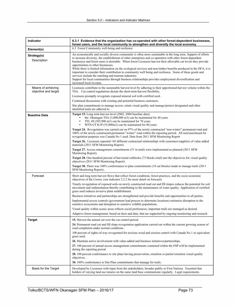
Section 5.0 – Indicators and Indicator Matrices
Tolko/BCTS/WFN Okanagan SFM Plan – 2016/17 Page 73
Indicator 6.3.1 Evidence that the organization has co-operated with other forest-dependent businesses, forest users, and the local community to strengthen and diversify the local economy
Element(s) 6.3 Forest Community well-being and resilience
Strategy(s) Description
An economically and socially diverse community is often more sustainable in the long term. Support of efforts to increase diversity, the establishment of other enterprises and co-operation with other forest-dependent businesses and forest users is desirable. When forest Licensees harvest their allowable cut levels they provide opportunities to other businesses. While there is limited information on the ecological services and non-timber benefits produced in the DFA, it is important to consider their contribution to community well being and resilience. Some of these goods and services include the ranching and tourism industries. Support for local communities through business relationships provides employment diversification and increased local revenue.
Means of achieving objective and target
Licensees contribute to the sustainable harvest level by adhering to their apportioned harvest volume within the TSA. Cut control regulations dictate the short-term harvest flexibility. Licensees promptly revegetate exposed mineral soil with certified seed. Continued discussions with existing and potential business customers. Site plan commitments to manage access, retain visual quality and manage/protect designated and other identified trails are adhered to.
Baseline Data Target 15. Long term harvest level (2002, 2004 baseline data): • the Okanagan TSA (3,000,000 m3) can be maintained for 40 years • TFL 49 (385,900 m3) can be maintained for 70 years • WFN-CF K1P (55,000m3) can be maintained for 80 years
Target 24. Revegetation was carried out on 97% of the newly constructed “non-winter” permanent road and 100% of the newly constructed permanent “winter” road within the reporting period. All seed purchased for revegetation purposes was Canada No 1 seed. Data from 2011 SFM Monitoring Report Target 26. Licensees reported 145 different contractual relationships with customers/suppliers of value added materials (2011 SFM Monitoring Report). Target 27. Access management commitments (31 in total) were implemented as planned (2011 SFM Monitoring Report). Target 28. One hundred percent of harvested cutblocks (73 blocks total) met the objectives for visual quality objectives (2011 SFM Monitoring Report). Target 30. There was 100% conformance to plan commitments (18 cut blocks) made to manage trails (2011 SFM Monitoring Report)..
Forecast Short and long term harvest flows that reflect forest conditions, forest practices, and the socio-economic objectives of the Crown. (see indicator 2.2.2 for more detail on forecast). Timely revegetation of exposed soils on newly constructed road cut and fill slopes reduces the potential for soil movement and sedimentation thereby contributing to the maintenance of water quality. Application of certified grass seed reduces invasive plant establishment. Business initiatives and partnerships are strengthened and provide benefits and opportunities to all parties. Implemented access controls (government lead process to determine locations) minimize disruption to the sensitive ecosystems and disruption to sensitive wildlife populations. Visual quality within scenic areas reflects social preferences; important trails are managed as desired. Adaptive forest management, based on facts and data, that are supported by ongoing monitoring and research
Target 15. Harvest the annual cut over the cut control period. 24. Permanent road cut and fill slope revegetation application carried out within the current growing season of road completion under normal conditions. 100 percent of rights-of-way revegetated for noxious weed and erosion control with Canada No.1 or equivalent grass seed. 26. Maintain active involvement with value-added and business initiatives/partnerships. 27. 100 percent of annual access management commitments contained within the FSP will be implemented during the reporting period. 28. 100 percent conformance to site plans having preservation, retention or partial retention visual quality objectives. 30. 100% conformance to Site Plan commitments that manage for trails.
Basis for the Target Developed by Licensees with input from the stakeholders, broader public or First Nations. Essential that holders of varying land use tenures on the same land base communicate regularly. Legal requirements.

Section 5.0 – Indicators and Indicator Matrices
Tolko/BCTS/WFN Okanagan SFM Plan – 2016/17 Page 74
Legal Requirements Forest Act, Cut Control Regulation, Heritage Conservation Act, Forest and Range Practices Act, Forest Planning and Practices Regulation
Monitoring & Measurement Periodic
The schedule for subsequent Timber Supply Reviews for the TSA and TFL’s can be found at: http://www.for.gov.bc.ca/hts/schedule.htm.
Annual Target 15. Licensees will report the harvest level allocated for each licence and harvest level cut (cut control volume) for the past reporting year. The existing scaling system in place (monitored by MOFLNRO) tracks volume delivered. Target 24. For permanent roads built under the authority of the Road Permit that provide access to one or more cutblocks, licensees will retain a record of permanent road construction and subsequent application of grass seed for the reporting period. The records will be used to provide a summary of timing of right-of-way revegetation application. Target 26. Report on value added and business initiatives/partnerships. Units will provide a file for tracking the grass seed purchased. Compile total amount of Canada No. 1 or equivalent seed purchased (kilograms) and compare to total seed purchased (kilograms) for the reporting period. Target 27. To enable reporting, Licensees utilize Forest Stewardship Plan access and timing restriction information. To determine the above has been achieved, refer to the information system for road completion status, access management commitment status, and other relevant information. Target 28. Report on the number of cutblocks harvested in the reporting period that had preservation, retention or partial retention visual quality objectives, and the number of cutblocks that achieved the visual intent as planned. Achievement of visual intent will be confirmed with photos from a key viewpoint demonstrating that operations provided results similar to plan. Target 30. Report on the number cutblocks harvested in the reporting period that had one or more commitments to manage for a trail (could be for hiking, biking, cattle, historic, etc) in the Site Plan. Also report whether those plan commitments were properly executed.
Variance 15. According to the Cut Control Regulation and Policy 24. Grass seed application occurs in the subsequent growing season. There is no variance provided for the remaining targets (26, 27, 28, 30)

Section 5.0 – Indicators and Indicator Matrices
Tolko/BCTS/WFN Okanagan SFM Plan – 2016/17 Page 75
Indicator 6.3.2 Evidence of co-operation with DFA-related workers and their unions to improve and enhance safety standards, procedures, and outcomes in all DFA-related workplaces and affected communities
Element(s) 6.3 Forest Community well-being and resilience
Strategy(s) Description
The BC Forest Safety Council was created in September 2004 after the release eight months earlier of a unanimous report from the provincial government’s Forest Safety Task Force. The mandate of the task force had been to set out a comprehensive strategy to reduce high levels of injuries and fatalities in the forest sector. Its membership consisted of representatives of companies, unions, independent contractors, forestry associations and the Workers’ Compensation Board of B.C. (since renamed WorkSafe BC). SAFE Companies is the flagship program of the BC Forest Safety Council, certifying B.C. forestry operations that show a commitment to safety and demonstrate, through audits, that their safety programs meet industry standards. This earns SAFE-certification status for companies of all sizes, from individual owner operators to the largest firms. More information is available at: http://www.bcforestsafe.org/index.html Effective January 1, 2009, certification became a pre-requisite to bid on BCTS contracts. The Ministry’s Forests For Tomorrow program also requires SAFE certification for its agreement holders. Licensees that subscribe to the SAFE Company program demonstrate a commitment to forest workers that they go home safely to their families at the end of each work day.
Means of achieving objective and target
Licensees require those who conduct forest operations be SAFE Company or equivalent registered and/or certified.
Baseline Data 137 out of 141 contractors (98.6%) were considered to have the SAFE certification or equivalent (2011 SFM Monitoring Report).
Forecast From 1998 to 2005, WorkSafe BC accepted an average of nearly 22 harvesting fatality claims each year — the worst in 2005 with 34 claims. But the industry averaged fewer than 14 fatalities from 2006 to 2008. While this 35-per-cent reduction is a step in the right direction, no fatality is acceptable. Companies and contractors who are SAFE Company or equivalent certified, demonstrate the efforts to make safety integral to each worker’s life, and that unsafe is unacceptable.
Target 38. 100% of contractors conducting on the ground work are SAFE Company registered and/or certified or they carry an equivalent safety program.
Basis for the Target Continuously improve forest worker safety record.
Legal Requirements Workers Compensation Act
Monitoring & Measurement Periodic
Annual Licensees will report: Number of on the ground contractors/BCTS Licensees in total working within their DFA and the number of those that are SAFE Company registered and/or certified – or that carry an equivalent safety program.
Variance None

Section 5.0 – Indicators and Indicator Matrices
Tolko/BCTS/WFN Okanagan SFM Plan – 2016/17 Page 76
Indicator 6.3.3 Evidence that a worker safety program has been implemented and is periodically reviewed and improved
Element(s) 6.3 Forest Community well-being and resilience
Strategy(s) Description
The BC Forest Safety Council was created in September 2004 after the release eight months earlier of a unanimous report from the provincial government’s Forest Safety Task Force. The mandate of the task force had been to set out a comprehensive strategy to reduce high levels of injuries and fatalities in the forest sector. Its membership consisted of representatives of companies, unions, independent contractors, forestry associations and the Workers’ Compensation Board of B.C. (since renamed WorkSafe BC). SAFE Companies is the flagship program of the BC Forest Safety Council, certifying B.C. forestry operations that show a commitment to safety and demonstrate, through audits, that their safety programs meet industry standards. This earns SAFE-certification status for companies of all sizes, from individual owner operators to the largest firms. More information is available at: http://www.bcforestsafe.org/index.html Effective January 1, 2009, certification became a pre-requisite to bid on BCTS contracts. The Ministry’s Forests For Tomorrow program also requires SAFE certification for its agreement holders. Licensees that subscribe to the SAFE Company program demonstrate a commitment to forest workers that they go home safely to their families at the end of each work day.
Means of achieving objective and target
Licensees subscribe to the SAFE Company program.
Baseline Data All forest companies report having SAFE certification (2011 SFM Monitoring Report).
Forecast From 1998 to 2005, WorkSafe BC accepted an average of nearly 22 harvesting fatality claims each year — the worst in 2005 with 34 claims. But the industry averaged fewer than 14 fatalities from 2006 to 2008. While this 35-per-cent reduction is a step in the right direction, no fatality is acceptable. Companies and contractors who are SAFE Company or equivalent certified, demonstrate the efforts to make safety integral to each worker’s life, and that unsafe is unacceptable.
Target 39. 100% of CSA SFM participating Licensees will be SAFE Company certified.
Basis for the Target Continuously improve forest worker safety record.
Legal Requirements Workers Compensation Act
Monitoring & Measurement Periodic
Annual Licensees will report a yes/no answer as to whether they are SAFE Company certified.
Variance none

Section 5.0 – Indicators and Indicator Matrices
Tolko/BCTS/WFN Okanagan SFM Plan – 2016/17 Page 77
Indicator 6.4.1 Level of participant satisfaction with the public participation process
Element(s) 6.4 Fair and Effective Decision Making
Strategy(s) Description
The SFM Advisory Group was formed to assist Tolko, BCTS and WFN in developing the SFM Plan by identifying local values, objectives, indicators and targets and evaluating the effectiveness of the Plan. The SFM Plan is an evolving document that will be reviewed and revised on an annual basis with the SFM Advisory Group to address changes in forest condition and local community values. Ensuring the continuing interest and participation of this important Group is a Licensee priority. Theabilityofpeopletoshareinformation,discussandsolveproblems,andsetandmeetobjectivesiskeytoachievingandmaintainingmeaningfulparticipation.
Means of achieving objective and target
Licensees provide all Advisory Group members, and interested public who have shown notable interest (written comments or SFM Plan meeting attendance) during the year, a feedback form (survey) to assess their satisfaction with the process. All survey questions will have a 1-5 scoring assessment (1 being poor or ineffective and 5 being excellent or highly effective).
Baseline Data Satisfied advisory group (2005 baseline data) a. Survey response was an average of 4.0 out 5.0. There were 14 respondents to the survey. b. Results of the feedback form were compiled and are reported as part of the annual monitoring
program in the Appendix of the Monitoring Report.
Forecast Active, engaged Public Advisory Group
Target 34. Advisory group feedback will result in: a. 80% of survey responses “3” or better b. All written comments are reviewed and considered, and all line responses with a rating averaging less than
3.0 become action items
Basis for the Target Ensure issues are identified discussed and where possible, resolved. Advisory Group process is being continuously improved.
Legal Requirements NA
Monitoring & Measurement Periodic
Annual a. Survey responses coded 1 (poor), 2, 3 (satisfactory), 4, 5 (well done). b. Results of feedback form compiled and reported as part of annual monitoring program.
Variance None
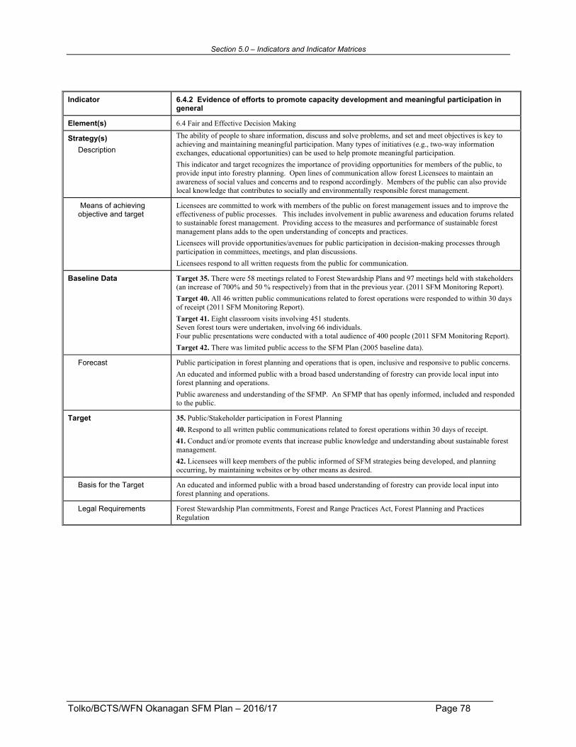
Section 5.0 – Indicators and Indicator Matrices
Tolko/BCTS/WFN Okanagan SFM Plan – 2016/17 Page 78
Indicator 6.4.2 Evidence of efforts to promote capacity development and meaningful participation in general
Element(s) 6.4 Fair and Effective Decision Making
Strategy(s) Description
The ability of people to share information, discuss and solve problems, and set and meet objectives is key to achieving and maintaining meaningful participation. Many types of initiatives (e.g., two-way information exchanges, educational opportunities) can be used to help promote meaningful participation. This indicator and target recognizes the importance of providing opportunities for members of the public, to provide input into forestry planning. Open lines of communication allow forest Licensees to maintain an awareness of social values and concerns and to respond accordingly. Members of the public can also provide local knowledge that contributes to socially and environmentally responsible forest management.
Means of achieving objective and target
Licensees are committed to work with members of the public on forest management issues and to improve the effectiveness of public processes. This includes involvement in public awareness and education forums related to sustainable forest management. Providing access to the measures and performance of sustainable forest management plans adds to the open understanding of concepts and practices. Licensees will provide opportunities/avenues for public participation in decision-making processes through participation in committees, meetings, and plan discussions. Licensees respond to all written requests from the public for communication.
Baseline Data Target 35. There were 58 meetings related to Forest Stewardship Plans and 97 meetings held with stakeholders (an increase of 700% and 50 % respectively) from that in the previous year. (2011 SFM Monitoring Report). Target 40. All 46 written public communications related to forest operations were responded to within 30 days of receipt (2011 SFM Monitoring Report). Target 41. Eight classroom visits involving 451 students. Seven forest tours were undertaken, involving 66 individuals. Four public presentations were conducted with a total audience of 400 people (2011 SFM Monitoring Report). Target 42. There was limited public access to the SFM Plan (2005 baseline data).
Forecast Public participation in forest planning and operations that is open, inclusive and responsive to public concerns. An educated and informed public with a broad based understanding of forestry can provide local input into forest planning and operations. Public awareness and understanding of the SFMP. An SFMP that has openly informed, included and responded to the public.
Target 35. Public/Stakeholder participation in Forest Planning 40. Respond to all written public communications related to forest operations within 30 days of receipt. 41. Conduct and/or promote events that increase public knowledge and understanding about sustainable forest management. 42. Licensees will keep members of the public informed of SFM strategies being developed, and planning occurring, by maintaining websites or by other means as desired.
Basis for the Target An educated and informed public with a broad based understanding of forestry can provide local input into forest planning and operations.
Legal Requirements Forest Stewardship Plan commitments, Forest and Range Practices Act, Forest Planning and Practices Regulation

Section 5.0 – Indicators and Indicator Matrices
Tolko/BCTS/WFN Okanagan SFM Plan – 2016/17 Page 79
Monitoring & Measurement Periodic
Annual Target 35. Documentation for Forest Stewardship Plan and other stakeholder meetings are kept at the appropriate Licensee’s office. Target 40. Retain and review documentation (often contained within the Licensee’s Forest Stewardship Plan) for responses to public communications related to DFA forest operations. Licensees will report on the number of responses sent out compared to the number of written requests for communication. Report the average timeline for response. Target 41. Licensees to report all activities where they conducted, participated in or sponsored events that increased public awareness of SFM. Examples would include classroom visits, forest tours, public presentations, trade shows and community fairs. Report on the number of people reached. Target 42. Licensees will report a yes/no answer as to whether web sites or other tools to disseminate information are being maintained, and whether SFMP and other information were made publicly available in the last year.
Variance None

Section 5.0 – Indicators and Indicator Matrices
Tolko/BCTS/WFN Okanagan SFM Plan – 2016/17 Page 80
Indicator 6.4.3 Evidence of efforts to promote capacity development and meaningful participation for Aboriginal communities
Element(s) 6.4 Fair and Effective Decision Making
Strategy(s) Description
The ability of people to share information, discuss and solve problems, and set and meet objectives is key to achieving and maintaining meaningful participation. Many types of initiatives (e.g., two-way information exchanges, educational opportunities) can be used to help promote meaningful participation. Open lines of communication allow forest Licensees to maintain an awareness of social values and concerns and to respond accordingly. First Nations members can also provide local knowledge that contributes to socially and environmentally responsible forest management. This indicator and related targets look specifically at First Nation participation in the forest economy: to look at open communications, Licensees’ efforts to build capacity within First Nations on matters related to the forest industry and to how traditional knowledge, non-timber resources, and cultural and spiritual values have been incorporated into in forest planning
Means of achieving objective and target
Licensees engage in building mutually beneficial relationships with Aboriginal peoples. Open communications with local First Nations during Plan reviews. Information sharing requires an understanding of all parties’ interests and in doing so, building capacity of those involved. Licensees actively listen and respond to requests to manage or protect non-timber resources, and cultural and spiritual values.
Baseline Data Target 32. There were 14 working partnerships with First Nation communities in the SFM Plan area (2011 SFM Monitoring Report). Target 37. There were 2 cutblocks where specific actions were requested. These two blocks have not been laid out yet, but it is the Licensee’s intent to buffer a trail as requested (2006 baseline data).
Forecast Licensees support First Nations in building organizational capacity. As responsible stewards of public forest land, Licensees engage in building mutually beneficial relationships with Aboriginal peoples. Open and meaningful communications with local First Nations leading to a trust in sharing sensitive information. Two way dialogue of and understanding of interests helps to build capacity for the parties involved.
Target 32. Support partnership opportunities (including training) with First Nations through mutually beneficial involvement in forest management. 37. Incorporation of traditional knowledge, non-timber resources, and cultural and spiritual values in forest planning where they have been identified and shared by willing aboriginal communities.
Basis for the Target Licensees engage in building mutually beneficial relationships with Aboriginal peoples. Communications process developed by Licensees with First Nations.
Legal Requirements Forest and Range Practices Act
Monitoring & Measurement Periodic
Annual Target 32. Documentation and reporting on First Nations partnerships and training sessions will be retained at the appropriate Licensee’s office. Target 37. Number of cutblocks where specific actions were requested and were taken, using traditional knowledge where available, to manage for and/or protect non-timber resources, and cultural and spiritual values.
Variance None

Section 5.0 – Indicators and Indicator Matrices
Tolko/BCTS/WFN Okanagan SFM Plan – 2016/17 Page 81
Indicator 6.5.1 Number of people reached through educational outreach
Element(s) 6.5 Information for Decision-Making
Strategy(s) Description
The Licensees are committed to working with directly affected stakeholders and members of the public on forest management issues and have a well-established history of participation in community meetings, including local planning processes. Organizations and the public provide and receive information through interactions with each other. The sharing of learning’s and opinions contributes to informed, balanced decisions and plans acceptable to the majority of public. When informed and engaged, members of the public can provide local knowledge that contributes to socially and environmentally responsible forest management.
Means of achieving objective and target
Licensees maintain their involvement and sponsorship in research and educational initiatives (e.g., summer students, post graduate research projects, volunteer sites for studies, association support – FERIC, Forest Products Association of Canada, etc.). Licensees will be involved with educational support to ensure the importance of resource management is conveyed. In addition to direct actions by Licensees and their employees, additional outside resources including the sharing of information on the website: http://thompsonokanagansustainableforestry.ca/okanagan_top.htm may be used to achieve the target.
Baseline Data Target 29. Numerous (over 15) educational or research initiatives occurred ranging from public school presentations to relationships with National research organizations (2011 SFM Monitoring Report).. Target 41. Eight classroom visits involving 451 students. Seven forest tours were undertaken, involving 66 individuals. Four public presentations were conducted with a total audience of 400 people (2011 SFM Monitoring Report).
Forecast Adaptive forest management, based on facts and data that are supported by ongoing monitoring and research. An educated and informed public with a broad understanding of forestry that can provide local input into forest planning and operations.
Target 29. Maintain involvement and sponsorship in research and educational initiatives (e.g., summer students, post graduate research projects, volunteer sites for studies, association support – FERIC, Forest Products Association of Canada etc.). 41. Conduct and/or promote events that increase public knowledge and understanding about sustainable forest management.
Basis for the Target Adaptive forest management should be based on facts and data, and supported by ongoing monitoring and research. An educated and informed public with a broad based understanding of forestry can provide local input into forest planning and operations.
Legal Requirements NA
Monitoring & Measurement Periodic
Annual Target 29. To enable reporting, documentation on research programs and educational initiatives will be retained at the appropriate Licensee’s office. Target 41. Licensees to report all activities where they conducted, participated in or sponsored events that increased public awareness of SFM. Examples would include classroom visits, forest tours, public presentations, trade shows and community fairs. Report on the number of people reached.
Variance None

Section 5.0 – Indicators and Indicator Matrices
Tolko/BCTS/WFN Okanagan SFM Plan – 2016/17 Page 82
Indicator 6.5.2 Availability of summary information on issues of concern to the public
Element(s) 6.5 Information for Decision-Making
Strategy(s) Description
This target recognizes the importance of keeping members of the public informed of forestry strategies being developed and planning occurring in their area. Open lines of communication facilitate public awareness and understanding of the SFMP and other current forestry topics, and provide an open opportunity for the public to respond. Members of the public can provide local knowledge that contributes to socially and environmentally responsible forest management.
Means of achieving objective and target
Licensees cooperatively manage a web site dedicated to providing the latest SFM Plan information, providing topical forestry information and links to other sources. Licensees develop and distribute the SFM Plan and performance results to the public annually, including a summary of research and extension initiatives.
Baseline Data Target 42. There was limited public access to the SFM Plan (2005 baseline data).
Forecast Public awareness and understanding of the topical forest issues and the SFM Plan. A continuously improving SFM Plan that has openly informed, included and responded to the public – one that is supported by ongoing monitoring and research..
Target 42. Licensees will keep members of the public informed of SFM strategies being developed, and planning occurring, by maintaining websites or by other means as desired.
Basis for the Target Developed by Licensees in consultation with the Public Advisory Group. Provides topical information to local public as well as a world wide audience. Has instant feedback mechanism for those looking for additional information.
Legal Requirements n/a
Monitoring & Measurement Periodic
Annual Target 42. Licensees will report a yes/no answer as to whether web sites or other tools to disseminate information are being maintained, and whether SFMP and other information were made publicly available in the last year.
Variance None

Tolko/BCTS/WFN Okanagan SFM Plan – 2015/16 Page 83
6.0 Links to Other Planning Processes and Policies Resource use planning in British Columbia occurs at a variety of levels ranging from strategic land use plans (LRMP’s) to site specific plans for small areas (e.g., site plans for individual cutblocks). Strategic land use plans provide broad direction for the sustainable management of land and resources through the establishment of resource management zones (e.g., protected areas, special management areas and general resource management zones), management objectives and strategies to guide land and resource management activities. Forest Stewardship Plans (FSP’s) address resource management at various scales and are often regulated by government objectives. These objectives come from a variety of sources including the Forest and Planning Practices Regulation, orders made under the Land Act, the Land Use Objectives Regulation, the Government Actions Regulation, and strategic land use plans such as the Kootenay Boundary Higher Level Plan Order. The Forest Stewardship Plans contain results and strategies to manage for these objectives set by government. There is little contradiction between these Plans and that of the SFMP for the DFA. In fact, the indicators and targets found in the SFMP are often complimentary to those found in a Licensee’s FSP. Figure 7 on the following page illustrates the links between various levels of provincial resource use plans and related policies and procedures.

Section 6.0 – Other Planning Processes and Policies
Tolko/BCTS/WFN Okanagan SFM Plan – 2016/17 Page 84
Legislation and Policy
Higher Level Plans (KBLUP) Land Use Plans
Landscape Unit
Forest Stewardship Plan
Licensee Plan (SP)
Management Plan (CFA, TFL, Woodlots)
Cutting Permit
Harvest & Silviculture Operations – on the Ground
TSA-SFM Plan Annual Monitoring Report
Annual Public Review
e.g. Forest & Range Practices Act Forest Act Fisheries Act WorksafeBC
Public Review Okanagan SFM Advisory Group Gov. Agency Review
Gov. Agency Review
Continual Improvement of TSA-SFM Plan & Licensee SFM Plan
Forest Resource Inventories
Research
Figure 7. Links Between Plans

Section 6.0 – Other Planning Processes and Policies
Tolko/BCTS/WFN Okanagan SFM Plan – 2016/17 Page 85
Existing legislation and policy contributes to sustainable forest management. Current legislation requires the identification of old growth management areas and wildlife/leave tree retention areas. There are also numerous policies and guidelines in place at the regional and district levels that contribute to the principles of sustainable forest management. These include the following:
• Public Involvement: Provincial direction for forest management on publicly owned lands includes a requirement to maintain a mix of opportunities that reflect changing resources and social values over time. Public involvement in Forest Stewardship Plan (FSP) reviews is intended to facilitate the exchange of information between developers and people interested in, or affected by, forest operations.
To ensure that public input can be considered in FSP development, comments must be submitted to the Licensee in writing. The Licensee’s response should document actions taken to accommodate public concern. This formal process ensures public concerns pertaining to items such as recreation features, visual quality, identified trails or other features of significance are identified. Early identification of issues enables the forest Licensee to adapt plans accordingly. Licensees in the within the Okanagan Defined Forest Area have a long-standing commitment to work with members of the public on forest management issues, and there is a well-established history of Licensee participation in community meetings, including local planning processes and strategic plans. In addition, Licensees are committed to providing topical education updates on forest management issues during meetings. This ensures the public and local First Nation tribal councils and bands have up-to-date information. Members of the public continue to support strategic and local planning processes and actively participate in meetings on forest management issues. Licensees are committed to improving the effectiveness of public processes in the TSA.
• Access Management: Access plans are co-coordinated by government with input from the public and forest resource stakeholders. Forest Licensees and proponents from other resource industries follow the advice and direction set by the government agencies through these planning processes. Presently access management is discussed at localized meetings with affected stakeholders and Licensees implement them through commitments made in their Forest Stewardship Plan. Access plans consider the condition of roads, road maintenance and deactivation, and the need for access restrictions based on long term objectives for an area. Access planning includes identifying potential impacts on resources such as wildlife, tourism, recreation, or other values due to open public access. Public access controls are implemented where required.
• Terrain stability: The Defined Forest Area (DFA) has significant climatic variations from wet conditions in the north to drier conditions in the south. Steep slopes and terrain conditions in the entire DFA have the potential for landslides and surface soil erosion. Landslides are a natural and inevitable phenomenon that contributes to the evolution of the landscape. Although landslides occur in both logged and unlogged terrain, logging and road building can increase their frequency. Impacts of landslides include acceleration of sediment delivery to streams, possible damage to fish and invertebrate habitat and productivity, loss of forest site productivity, unsightly scars and damage to roads, culverts and bridges. The Forest
Section 6.0 – Other Planning Processes and Policies
Tolko/BCTS/WFN Okanagan SFM Plan – 2016/17 Page 86
and Range Practices Act (FRPA) stipulates that forest harvesting and road construction must not cause landslides (FPPR 37). The following are examples of the process undertaken to minimize landslides: i. Assess all steep/sensitive terrain prior to road construction or harvesting to evaluate
terrain stability and provide recommendations on: ! whether or not development should proceed; ! best road and cutting boundary locations or changes to proposed layout or road
alignment; ! riparian management areas; ! possible mitigative actions and criteria; and ! road construction and harvesting constraints or special techniques.
ii. Inspections of drainage ditches and culverts regularly and take preventative measures to minimize the potential for debris flow initiation and soil erosion.
• Road construction and maintenance procedures: Certain soil types are sensitive to
disturbance especially from road construction and harvesting activities involving mobile equipment such as excavators and skidders. These sensitive soils are identified in advance to help prevent/minimize soil compaction, poor drainage, puddling and soil displacement that result in loss of productive forest sites. With respect to forest roads, the soil and water information collected during the planning phase and future expected use of the road are used to determine the type of road constructed and level of maintenance, deactivation or rehabilitation to be prescribed. Deactivation and rehabilitation provides a distinction between the varying construction standards and duration of roads as follows:
! Deactivation: The intent is to control water and maintain natural drainage patterns based on the risks associated. Activity includes: cross ditches, waterbars, backup drainage control or removing culverts, bridges, seeding and revegetation and pulling back of material (recontouring or returning material).
! Rehabilitation: some of the same prescriptions above may be completed to control water and maintain natural drainage; however, the intent is to have the site capable of growing a productive crop of trees. Potential strategies may include pulling back of material (recontouring or returning material), seeding and revegetation and decompaction.
There are two administrative categories of road types: status and non-status. i. Status roads are ones held under road permit or road use permit by Licensees. These
permits give the Licensees responsibility for maintaining the roads. There are two types of status roads: ! permanent roads are long term roads that may be deactivated for control of water ! temporary roads are short-term roads that will be rehabilitated – including water
management – to return the area into a productive growing site. Commitments related to the amount of permanent access structures (i.e. roads, gravel pits) are included in site-specific plans. Temporary access structures included in plans are part of the net area that requires reforestation and must be suitably treated to enable tree survival and growth.
i. Non-status roads have no assigned permit holder and responsibility is that of the Crown (usually old trails and roads)

Section 6.0 – Other Planning Processes and Policies
Tolko/BCTS/WFN Okanagan SFM Plan – 2016/17 Page 87
The new Forest Stewardship Plans contain several results and strategies where road construction and deactivation are referenced, and that must be met or implemented. Communication and input by the public, other resource users and resource agencies are important to ensure access meets necessary requirements.
• Invasive Plants: Invasive plants are non-native plant species that can be difficult to control. They can have a significant impact on agriculture and timber production, reducing forage production for livestock and wildlife and threatening forest regeneration. They may also alter the structure of natural plant communities, threatening biodiversity. The most effective strategy for controlling invasive plants is to prevent their establishment. Once established, the cost and difficulty of controlling invasive plants increases significantly. The Licensees have committed to promptly re-vegetate road cuts and fills in order to reduce the spread of invasive plants..
• Quality of seed for revegetation of rights-of-way: Grass seeding is carried out for three reasons: 1) invasive plant control; 2) erosion prevention; and, 3) to provide forage. The seed used for revegetation is graded by Agriculture Canada to protect against the presence of invasive plants and other unwanted species. Measures used to ensure seed quality in the production cycle include sowing seeds with clean equipment, crop inspection, crop certificate permitting seed from inspected crop to be sold as certified seed, seed crop harvested with clean equipment, seed inspected, graded and sealed to Canada Seeds Act requirements by Agriculture Canada.
• Pest Management: The Licensees are required under their Crown licenses to address forest
pest/health at the operational level. Managing for health must take into account the natural variability and cyclical variations that occur on the landscape. Management for forest health includes both preventive action and proactive response measures. Examples include participation in overview flights, focused reconnaissance action resulting from overview flights, strategies and coinciding action plans, communication, implementation and review.
• Forest Industry-Caused Wildfires: The forest industry has numerous legal requirements to
minimize the potential for wildfires being started by forest operations. Licensee employees and contractors are trained and knowledgeable in preventing and actioning wildfires. During fire season, the Licensees monitor fire weather indices, which help determine the level of risk in terms of forest operations. Fire prevention activities such as maintaining fire watch and moving to early shift help reduce the risk of fires starting and spreading as a result of industrial operations. Wildfires are a natural part of ecosystem rejuvenation. However, human safety and potential loss of resources plays a role in strategies to control loss.
• Free to Grow Silviculture Practices: A free growing stand is defined in the legislation as a
healthy stand of trees of a commercially valuable species, the growth of which is not impeded by competition from plants, shrubs or other trees. Prior to 1987, the Ministry of Forests, Lands and Natural Resource Operations funded all stand establishments to the free to grow stage on Crown lands.

Section 6.0 – Other Planning Processes and Policies
Tolko/BCTS/WFN Okanagan SFM Plan – 2016/17 Page 88
With a change to the Forest Act that year, stand establishment (basic silviculture) became the financial responsibility of the Licensee. The regeneration date is the date by which at least the minimum number of healthy well-spaced trees of the preferred and acceptable species per hectare must be established and subsequently maintained until the stand is declared free growing. The free growing assessment period is the time within which a free growing stand must be established as required in the Licensee Plan. A survey must be conducted on or before the latest free growing date to determine whether the number of free growing trees per hectare meets the number set in the Licensee Plan. Periodic monitoring and/or assessments are completed between the harvest and free growing dates.
• Genetic diversity: The Ministry of Forests, Lands and Natural Resource Operations Tree Improvement Branch (TIB) oversees the development and implementation of regulations, guidelines, policies and standards to ensure that tree seed used for Crown land reforestation is locally adapted and contains sufficient genetic diversity. To conserve the genetic diversity of the province’s forests, tree breeders collect hundreds of samples of tree species. Collections range from places where the species are found in large quantities to isolated populations at the edge of where they grow naturally. Breeders ensure that enough trees are selected to provide a level of diversity that will buffer future forests from environmental extremes and insect and disease attacks. In addition to breeding protocols, the genetic diversity of British Columbia’s trees is protected in parks, protected areas and in special reserves that are established by making “duplicates” of parent trees. All trees planted on Crown lands must have originated from seed registered by the BC Tree Seed Centre. The Centre has strict requirements for tree seed acceptability, selection and storage. More information on the Tree Improvement Branch and the Seed Centre can be found at the website: http://www.for.gov.bc.ca/HTI/.
• Seed and Vegetative Material Transfer Guidelines: Seed and vegetative material transfer guidelines are intended to minimize the risks of maladaptation or growth loss associated with regenerating trees (planted from seed or vegetative material) in a different location from their source. Transferring seeds or vegetative materials beyond the limits specified in the guidelines may decrease productivity or increase susceptibility to frost, insects or disease. With respect to genetic diversity, these guidelines geographically limit the amount of natural change and spread of seed or vegetative material over the landscape. The transfer guidelines must be adhered to when prescribing reforestation measures in Licensee plans. The government has implemented its Future Forest Strategy that recognizes the impact that climate change may have on future forests and how seed transfer guidelines may need to be modified.
• Wildlife Tree Retention: During forest development planning, Licensees incorporate a
number of strategies for maintaining diversity of structure and function within cutblocks. These include wildlife/leave tree retention, either in single trees or patches, as described in the Wildlife Tree Retention Guidance, May 2006 document.. During operational activities, tree species of merchantable size will be retained, where this is in keeping with safety standards of Worksafe BC.

Section 6.0 – Other Planning Processes and Policies
Tolko/BCTS/WFN Okanagan SFM Plan – 2016/17 Page 89
Included are green trees that will develop into wildlife trees. Characteristics that make broad leaf trees and conifers suitable as future wildlife/leave trees include large diameter and height, and structural features such as cavities, loose bark, dead tops, and signs of damage or rot. Also retained are trees of suitable quality and productivity that can act as seed trees to aid in the natural regeneration of harvested areas. Locating wildlife/leave trees in unique microsites, in known habitat areas, and along riparian areas can contribute to long-term forest function and biodiversity.
The intent is to provide wildlife tree patches that are windfirm and that will provide standing live and dead trees for habitat within or on the edge of harvested areas for the course of the rotation. Where merchantable trees in adjacent areas are not threatened, natural processes will be allowed to take their course within wildlife tree patches. Trees that burn, are attacked by insects, or are blown down contribute to biodiversity objectives. Other strategies for managing a diversity of vertical structure within cutblocks include regenerating a diversity of tree species and maintaining understory vegetation. Other aspects of maintaining structural diversity within cutblocks include providing a diversity of tree species, maintaining understory vegetation, and retaining coarse woody debris on sites after logging.
• Visual management: Visually sensitive areas are viewsheds or viewscapes visible from communities, public use areas and travel corridors, or viewpoints identified through a variety of referral or planning processes where the maintenance of visual quality is important. The OSLRMP identified and mapped the priority (Zone 1) areas for visual management. Planned harvesting within this priority area requires a visual impact assessment and operations must be conducted to maintain visual quality. Measures to maintain visual quality are included in Licensee plans.
• Archaeology: During plan development, cutblock and road proposals are provided to archeologists to determine if there is potential significance through an archaeological overview assessment. If yes, then additional fieldwork is scheduled as an archaeological impact assessment and any necessary changes are incorporated into the appropriate Licensee plan
• Carbon Balance: Forests have great potential to sequester and store carbon from the atmosphere. Given this, managers should recognize the imperative of keeping forest lands in vigorous tree growth at all times. This often means understanding any age class imbalances and strategies for correction. It also includes ensuring prompt tree regeneration following disturbances such as timber harvests and converting the smallest possible amount of forest land to non-forest land during forest operations (e.g., minimizing roads and landings). Forest carbon has recently become a key SFM value, especially in light of Canada’s international commitment to lower its net carbon outputs to the atmosphere. Models for calculating a forest carbon budget (e.g., the Canadian Forest Service’s Carbon Budget Model of the Canadian Forest Sector (CBM-CFS3)) are becoming available for use by practitioners particularly where they can be linked to forest inventory and timber supply models. Their use in forest planning can indicate whether a specific forest is expected to be a net carbon source or sink over the period normally used for wood-supply forecasts.

Section 6.0 – Other Planning Processes and Policies
Tolko/BCTS/WFN Okanagan SFM Plan – 2016/17 Page 90
A retrospective analysis of the forest carbon budget for BC (1920-1989) revealed that forest ecosystem carbon storage has increased from 14.2 Pg C in 1920 to 18.1 Pg C 1990 (Pg stands for petagram =one billion metric tonnes or 1000 x one billion kg). The increase in ecosystem C storage is attributed to an increase in the average age of forests and to the associated accumulation of C in biomass and soil and detritus pools. The average annual increase in ecosystem C storage over the 70-year period was 55.2 Tg C yr1 (Tg stands for teragram = one million metric tonnes or 1000 x one million kg. One teragram is also equivalent to one megatonne or Mt). In figure 10 following, the Interior Cordilleran (lower left) graph provides an indication of how this applies to the Okanagan.
Figure 8. Changes to the total above ground and below ground biomass C (ο), soil (Δ) and forest product sector (♦) by ecoclimatic provinces from 1920 to 1989. The steady increase to carbon stored can be attributed to large scale natural disturbances of the previous century (where large amounts of carbon were released).

Section 6.0 – Other Planning Processes and Policies
Tolko/BCTS/WFN Okanagan SFM Plan – 2016/17 Page 91
Since these disturbances, forests have been in a rigorously growing phase sequestering large amounts of carbon. As time progresses, these forests will lose their ability to take up large amounts of carbon. They will also become more susceptible to large scale natural disturbances such as that occurring presently with Mountain Pine Beetle. The following graph (Figure 11) provides an illustration of the overall carbon cycle within Canada:
Figure 9. Carbon cycle within Canada. In a 2009 Report - Carbon Management in British Columbia’s Forests: Opportunities and Challenges, authors Mike Greig and Gary Bull consolidated forest carbon management information currently available for British Columbia in the policy, research, and operational communities. They summarized the forest carbon cycle as: “Net changes in forest carbon stocks determine whether a forest ecosystem is a net source of atmospheric carbon or a net sink of atmospheric carbon. Overall, it is the forest’s net carbon balance that must be accounted for by adding up the ever-changing contributions of all the stands. For example, when a tree is harvested, carbon is removed in the logs, but 40–60% of the tree biomass (branches, roots, leaves) remains in the forest where it decomposes slowly and gradually releases nutrients and CO2. The harvested areas also regenerate so that over time a substantial new pool of carbon is created. Harvested logs are sent to mills for conversion into forest products, such as lumber, panels, or paper. Depending on the use and disposal of these products, the carbon may be stored for a very long time, or it may be released into the atmosphere relatively quickly. About 45–50% of the carbon harvested and removed from the forest is stored in long-lasting structures such as houses. This carbon is not released back into the atmosphere until, for instance, a house is torn down many decades later and the wood is burnt or sent to landfills. About 25–30% of the carbon goes into less durable products such as wooden pallets, or quickly disposed of newspapers and other paper goods.

Section 6.0 – Other Planning Processes and Policies
Tolko/BCTS/WFN Okanagan SFM Plan – 2016/17 Page 92
Strategies prolonging the storage of carbon in wood products and landfills can help to reduce green house gas emissions. The remaining carbon (about 25%) is in the bark and leftover wood pieces, which are often used to fuel pulp and paper mills, thus providing a renewable energy substitute for fossil fuels (Natural Resources Canada 2007). In most Canadian forests, however, more carbon exists in soils and dead organic matter than in the living biomass”. The report notes the interest in managing British Columbia’s forests for climate control and CO2 offsetting projects has built to the point where forest managers are seeking guidance. “Equally important is the public’s desire to understand the potential of provincial forests in mitigating climate change and to have this clearly communicated. Some work has taken place in assembling carbon yield curves, researching local carbon storage (Kranabetter and Macadam 2006), and undertaking carbon accounting projects. However, no published handbooks or policies exist to guide forest managers, practitioners, or the public”. The report includes example of carbon offsetting projects such as:
• Afforestation/Reforestation: Creating a forest where none has existed in recent history (e.g., planting trees on agricultural land, urban landscapes, riparian areas and parks, and on previously degraded forest sites such as old roads and landings). • Avoided/reduced deforestation: Avoiding or reducing the permanent loss of forest (e.g., narrowing of cleared rights-of-way on utilities and roadways, reducing road density, and reducing site degrading processes). • Forest Management: Managing activities or changing the level of an existing activity within forest areas to increase carbon sequestration and to reduce or avoid emissions (e.g., fire and pest management; intensive silviculture involving fertilization and the use of faster-growing tree species; prompt reforestation of sites that might not regenerate quickly; extension of harvest rotations; reclamation of slash piles; use of differing tree retention levels in harvest areas; and rehabilitation of skids trails and roads).
Finally the report concludes by recognizing the uncertainty that exists in managing forests for carbon. “But who are the forest managers that will be compensated for managing forests for carbon stock? And who owns the carbon credits? A carbon credit is generated on the amount of carbon sequestered above the normal business practice for an area, or “in addition to” what would have occurred had no change in management strategy taken place. On private land, the landowner is generally considered to be the forest manager and owns carbon credits the land generates. British Columbia, however, comprises almost 48 million ha productive Crown forest land. Who owns the carbon credits generated on Crown forest land? Companies that wish to establish carbon sequestration projects or simply alter forest management practices to increase carbon storage or uptake on Crown land will require some level of certainty to the ownership before investing in these projects. This remains one of the province’s key challenges. Given the province’s vast forested area, its advanced levels of forest management, and the presence of knowledgeable forest managers and communities in all parts of British Columbia, Crown land offers great opportunities for forest carbon stock management. Logically, the forest manager should reap the benefits, although implications

Section 6.0 – Other Planning Processes and Policies
Tolko/BCTS/WFN Okanagan SFM Plan – 2016/17 Page 93
exist for those who do not presently have Crown tenure. This leads to the need for incentives that encourage innovative approaches or practices leading to carbon sequestration/storage or reduction of impacts on sequestration/storage.” In British Columbia, two models have generally been used to calculate carbon stock. The first, developed by the Canadian Forest Service (CFS), is a net volume-to-biomass conversion model that estimates the gross biomass quantity based on the net merchantable volume (an attribute readily available in our forest inventory) (Boudewyn et al. 2007). This carbon-stock calculator is used in conjunction with the CFS carbon accounting model, Carbon Budget Model of the Canadian Forest Sector 3 (cbm-cfs3). The second model (forecast), developed at the University of British Columbia, uses a different technique whereby biomass accumulation (live and dead) is modeled directly for the various components of forest ecosystems (a bottom-up approach). Volume is calculated as a function of stemwood biomass and tree height, if needed. The level of carbon budget analysis in British Columbia relies largely on the forest inventory (species and growth rates) and underlying assumptions the forest management regime and what makes up the timber harvesting land base. Because of some of the uncertainty surrounding the data inputs, it can be difficult to tease out changes in carbon sequestration modeling that are strictly as a result of changes to a particular management regime. This creates difficulties for forest managers who are trying to understand the carbon balance implications of various management regimes. Licensees will continue to monitor the evolving field of carbon budgets and offsets and look for opportunities to positively contribute to the carbon cycle.
• Allowable Annual Cut (AAC) determination: The AAC is the allowable rate of timber harvesting in a management unit such as timber supply area (TSA) or a tree farm licence (TFL). The Chief Forester sets the AAC for each of the province’s Timber SupplyAreas and Tree Farm Licences. The Regional Executive Director sets the AAC for Community Forest Licences and Woodlot Licences.
Timber supply is the rate at which timber could be made available for harvesting. It is a measure of the potential flow of logs out of the forest. It is not the same as the inventory or amount of wood in the forest. The size and productivity of a given area of land available for timber harvesting (timber harvesting land base) are factors used to determine the amount of timber that can be produced over time. Economic, environmental and social factors affect the rate of timber harvesting and the methods used. Economic factors may include prices for wood products, location and quality of timber, and costs of production. Environmental considerations include wildlife habitat, riparian buffers and environmentally sensitive areas. Examples of social factors are visual appearance of the landscape and drinking water quality and supply. Timber supply analysis is a process that explores the effects on timber supply of existing or possible future forest management strategies and alternative timber harvesting levels. The analysis makes it possible to compare how alternative management strategies affect forest structure and timber production over time. The steps in timber supply analysis to support AAC determination include:

Section 6.0 – Other Planning Processes and Policies
Tolko/BCTS/WFN Okanagan SFM Plan – 2016/17 Page 94
i. Categorize the land base – define the timber harvesting land base by separating lands suitable for timber production from lands unavailable or inappropriate for timber production (e.g., protected areas or inaccessible terrain). Lands outside of the timber harvesting land base are still part of the provincial forest and contribute to and are managed for other values (e.g., wildlife habitat, old growth).
ii. Project growth and yield – growth and timber yield are projected for each stand based on current management. These projections show the characteristics of a stand (e.g., timber volume per hectare, average stem diameter) at different ages.
iii. Identify management activities and requirements – current management practices – including those that enhance timber production (e.g., planting) and those that maintain or enhance other values (e.g., wildlife habitat, visual quality) – are identified and the amount and timing of each activity is specified. It is often necessary to restrict some activities in some areas to achieve multiple objectives.
iv. Model timber supply based on current management – a computer model is used to simulate the way a stand grows and is harvested over time. Forecasting occurs out for the next 250 years.
v. Run sensitivity analyses – sources of uncertainty in the data and management assumptions are analyzed to determine which factors most affect analysis results (e.g., where small changes in a management objective can cause large changes in timber supply). This knowledge helps to establish priorities for collecting new information and indicates where caution is required in interpreting results.
In setting an AAC, the Chief Forester considers information such as biodiversity, wildlife, and the social impacts of changes to timber supply including: ⇒ the rate of timber production that may be sustained from the area; ⇒ the short- and long-term implications to the province of alternative rates of timber
harvesting from the area; ⇒ constraints on the amount of timber produced from the area due to use of the forest
for purposes other than timber production; ⇒ the nature, production capabilities and timber requirements of established and
proposed processing facilities; ⇒ the economic and social objectives of the Crown, for the area, the region and the
province, as expressed by the Minister of Forests and Range; and, ⇒ abnormal insect or disease infestations and major salvage programs planned for the
area. ⇒
Ultimately the Chief Forester’s AAC determination is based on independent professional judgment.
.

Tolko/BCTS/WFN Okanagan SFM Plan – 2016/17 Page 95
Glossary of Terms


Tolko/BCTS/WFN Okanagan SFM Plan – 2016/17 Page 97
Glossary of Terms Abbreviations/Acronyms Acronym Meaning Acronym Meaning
AAC Allowable Annual Cut MOE Ministry of Environment BCTS British Columbia Timber Sales MOFLNRO Ministry of Forests, Lands and
Natural Resource Operations BEC Biogeoclimatic Ecosystem
Classification NAR Net Area to Reforest
CFA Community Forest Licence NDT Natural Disturbance Type
CSA Canadian Standards Association NP Non-Productive CWD Coarse Woody Debris NTHLB Non Timber Harvesting Land
Base DFA Defined Forest Area OGMA Old Growth Management Area DFO Department of Fisheries and
Oceans OSFMP Okanagan SFMP
EMS Environmental Management System
OSLRMP Okanagan Shuswap Land and Resource Management Plan
ESA Environmentally Sensitive Area RMZ Resource Management Zone FERIC Forest Engineering Research
Institute of Canada SFM(P) Sustainable Forest Management
(Plan) FPAC Forest Products Association of
Canada SP Site Plan
FPC Forest Practices Code of BC Act SU Standards Unit FPPR Forest Planning and Practices
Regulation TDG Transportation of Dangerous
Goods FRPA Forest and Range Practices Act TFL Tree Farm Licence FSP Forest Stewardship Plan THLB Timber Harvesting Land Base FSSIM Forest Service Simulation Model TSA Timber Supply Area GAR Government Actions Regulation TSL Timber Sale Licence HLP Higher Level Plan TSR Timber Supply Review IWMS Identified Wildlife Management
Strategy VQO Visual Quality Objective
KBLUP Kootenay Boundary Land Use Plan WFN Westbank First Nation LRMP Land and Resource Management
Plan WFN-CF Westbank First Nation Community Forest
LU Landscape Unit WHA Wildlife Habitat Area LUP Land Use Plan WTP Wildlife Tree Patch WTRA Wildlife Tree Retention Area

Tolko/BCTS/WFN Okanagan SFM Plan – 2016/17 Page 98
Definitions The following definitions were taken from the Canadian Standards Association (CSA) Sustainable Forest Management; Requirements and Guidance Z809, the Okanagan-Shuswap LRMP, the Forest Act, the Forest and Range Practices Act or provided by the Licensees. Aboriginal Rights: are recognized and affirmed by Sec. 35(1) of the Constitution Act, 1982. Aboriginal rights involve practices that were integral to the aboriginal society before contact. For example, Aboriginal rights may include (but are not limited to) fishing, hunting, gathering, trapping, and the use of land and resources for social, medicinal, spiritual and ceremonial purposes (Sparrow Decision, Guerin Decision, Calder Decision, Jack Decision). Generally the priority set in the Courts is conservation first, aboriginal rights to carry on an activity and/or practice next. (SFM Advisory Group)
Aboriginal Title: (Delgamuukw Decision): is an Aboriginal right recognized and affirmed in Section 35(1) of the Constitution Act, 1982. Aboriginal title is right to the land itself and encompasses the right to exclusive use and occupation of the land held pursuant to that title for a variety of purposes, which need not be aspects of those aboriginal practices, customs and traditions that are integral to distinctive aboriginal cultures (Para 177). Aboriginal title also encompasses within it a right to choose to what ends a piece of land can be put (Para 168). (SFM Advisory Group)
Adaptive management –a learning approach to management that recognizes substantial uncertainties in managing forests and incorporates into decisions experience gained from the results of previous actions. (Can/CSA Z809 – 02)
Biodiversity (or biological diversity) – the diversity of plants, animals, and other living organisms in all their forms and levels of organization, including genes, species, ecosystems, and the evolutionary and functional processes that link them. (Glossary of Resource Planning Terms)
Cultural heritage resource – means an object, a site or the location of a traditional societal practice that is of historical, cultural or archaeological significance to British Columbia, a community or an aboriginal people. (Forest Act)
Defined Forest Area (DFA) – a specified area of forest, including land and water (regardless of ownership or tenure) to which the requirements of this Standard apply. The DFA may or may not consist of one or more contiguous blocks or parcels. (Can/CSA Z809 – 02)
Forest resources – all resources and values associated with forests and range including, without limitation, timber, water, wildlife, fisheries, recreation, botanical forest products, forage, and biological diversity. (Forest Practices Code of British Columbia Act)
Free growing stand – a stand of healthy trees of a commercially valuable species, the growth of which is not impeded by competition from plants, shrubs or other trees. (Forest and Range Practices Act)
Indicator – a variable that measures or describes the state or condition of a value (see Figure 5 of Standard). (Can/CSA Z809 – 02)

Tolko/BCTS/WFN Okanagan SFM Plan – 2016/17 Page 99
Information System – A system to manage harvesting, road activities and reforestation obligations and commitments. (The Licensees)
Invasive Plant – means a plant listed in the Invasive Plants Regulation (B.C. Reg. 18/2004). (Forest and Range Practices Act)
Licensee – includes Tolko Industries Ltd., B.C. Timber Sales (BCTS) and Westbank First Nation (WFN)
Licensee plans – detail the logistics for forest and range development in particular locations. Methods, schedules and responsibilities for accessing, harvesting, renewing, and protecting the resources are set out to enable site-specific operations to proceed. Licensee plans include Forest Stewardship Plans, harvest plans, range use plans, fuel management prescriptions, and site plans.
Objective – a broad statement describing a desired future state or condition of a value (see Figure 5 of Standard). (Can/CSA Z809 – 02)
Old growth management area – means an area that is subject to old growth management objectives established under section 3 [resource management zones and objectives] or 4 [landscape units and objectives] of the Forest Practices Code of British Columbia Act. (Forest Planning and Practices Regulation)
Permanent access structure – means an access structure in a cutblock that a) at the time of its construction, is reasonably expected to provide access for timber harvesting and other activities that are not wholly contained in the cutblock, or b) is constructed on or through, or contains, materials unsuitable for the establishment of a commercial crop of trees and is not an excavated or bladed trail (Forest Planning and Practices Regulation)
Pest -- means an injurious, noxious or troublesome living organism but does not include a virus, bacteria, fungus or internal parasite that exists on humans or animals. (Provincial Pesticide Control Act)
Potential natural community (PNC) – the biotic community that would become established on an ecological site if all successional sequences were completed without interference by humans under the present environmental conditions. Natural disturbances are inherent in its development. The PNC may include acclimatized or naturalized non-native species. (Ministry of Forests and Range Management Guidebook)
Range development – means (a) ) a structure, (b) an excavation, (c) a livestock trail indicated in a range use plan or a range stewardship plan as a range development, or (d) an improvement to forage quality or quantity on an area that results from (i) the application of seed, fertilizer or prescribed fire to the area, or (ii) the cultivation of the area (Forest and Range Practices Act) Recreation feature – means a biological, physical, cultural or historic feature that has recreational significance or value. (Forest and Range Practices Act)
Resource feature – includes all of the following: (a) a cultural heritage resource; (b) a recreation feature; and (c) a range development that is a structure, excavation or constructed livestock trail. (Forest Practices Code of British Columbia Act)

Tolko/BCTS/WFN Okanagan SFM Plan – 2016/17 Page 100
Riparian reserve zones – means an area described under Division 3 [Riparian areas] of Part 4 [Practice requirements], that (a) is a portion of a riparian management area, and (b) is established to protect fish, wildlife habitat, biodiversity and the water values of the riparian reserve zone (Forest and Range Practices Act - Forest Planning and Practices Regulation)
Rare ecosystem – is an ecosystem (site series or surrogate) that makes up less than 2 percent of a landscape unit and is not common in adjacent landscape units. (Forest Practices Code of British Columbia Act, Biodiversity Guidebook)
Rare physical environment – a landscape where very uncommon features are present including wildlife, plants, vegetation associations and rock formations (Okanagan-Shuswap LRMP)
Seral stage distribution – the stages of ecological succession of a plant community (e.g., from young stage to old stage). The characteristic sequence of biotic communities that successively occupy and replace each other by which some components of the physical environment become altered over time. (Glossary of Resource Planning Terms)
Stubs – Merchantable residual tree cut by a mechanical harvester and retained during harvest with an approximate height of 3-5 meters. (The Licensees)
Sustainable forest management – management to maintain and enhance the long-term health of forest ecosystems, while providing ecological, economic, social, and cultural opportunities for the benefit of present and future generations. (Can/CSA Z809 – 02)
Sustainable forest management system – the structure, responsibilities, practices, procedures, processes, and timeframes set by a registration applicant for implementing, maintaining, and improving sustainable forest management. (Can/CSA Z809 – 02)
Target – a specific statement describing a desired future state or condition of an indicator. Targets should be clearly defined, time-limited, and quantified, if possible (see Figure A.4 of the Standard). (Can/CSA Z809 – 08)

Tolko/BCTS/WFN Okanagan SFM Plan – 2016/17 Page 101
Appendix 1
Defined Forest Area Map


Tolko/BCTS/WFN Okanagan SFM Plan – 2016/17 Page 103
"
"
"
"
"
"
"
" "
"
"
"
""
" "
"
"
Lumby
Chase
Oliver
Vernon
Enderby
Osoyoos
Kelowna
Sicamous
Keremeos
Armstrong
Peachland
Penticton
Coldstream
Summerland
Salmon Arm
Revelstoke
Spallumcheen
Lake Country
Defined Forest Area
January 2014
TSA
Park
Highway
BC Timber SalesTolko
A18666 (Stella-Jones)
A20191 (Arrow)
FL's (Okanagan)
T0816
TFL49
Westbank First Nation
Westbank - Community Forest K1P
Woodlot W0346
Westbank - FL A91134
0 20 40Km
1:1,200,000
®

Tolko/BCTS/WFN Okanagan SFM Plan – 2016/17 Page 104

Tolko/BCTS/WFN Okanagan SFM Plan – 2016/17 Page 105
Appendix 2: Information for Future Consideration The Licensees and the Sustainable Forest Management Advisory Group decided that the "parking lot" items should be added to the SFM Plan as an appendix to ensure the ideas are not forgotten. Items were placed in the parking lot generally because they lacked information or a practical means of measurement. Information below will be revisited periodically to determine if new information allows for their incorporation into the indicator set.
Genetic Diversity There have been a number of published reports on the genetic conservation of forests that document provincial gene conservation efforts (http://www.for.gov.bc.ca/hre/forgen/geneconoverview.htm). The 2010 BC State of Forest Report summarizes the state of genetic diversity in the province as follows: “Forest tree genetic resources are currently well represented in British Columbia’s protected areas network. Standards for seedlot genetic diversity and seed use support the use of adapted, productive, and resilient reforestation stock on public land. Forest genetics research and tree breeding are well established and supported by recent developments in climate modeling, genecology, and genetic conservation. Development of a climate-based seed transfer system is underway, including interim changes to seed transfer limits. A provincial strategy for management of the province’s genetic resources is in place.” Continue to monitor developments and research related to genetic diversity.
Species Diversity Continue to monitor/review research that may have applicability in development/refinement of species targets that assess forest habitat and connectivity.
Grass Seed application vs. germination and establishment (added February, 2010) Agreed to continue to look for efficient ways to assess results (actual grass establishment on exposed soils where it is applied) as opposed to the action of applying the seed.

Tolko/BCTS/WFN Okanagan SFM Plan – 2016/17 Page 106
Appendix 3 – SFM Plan Reporting
Tolko/BCTS/WFN Okanagan SFM Plan – 2016/17 Page 107
Appendix 3
SFM Plan Reporting Format
The following table is the reporting form that Licensees will use when reporting the results of monitoring the SFM Plan. The Plan will be monitored annually and the information will contribute to an annual review to confirm that CSA that performance measures are being met. The SFM Advisory Group will review and comment on the annual report.

Appendix 3 – SFM Plan Reporting

Appendix 3 – SFM Plan Reporting
Tolko/BCTS/WFN Okanagan SFM Plan – 2016/17 Page 109
Okanagan/Boundary Sustainable Forest Management Plan Annual Report Licensee Name and Reporting Year: ______________________________________________________________________
Tar #
Indicators (that target applies to)
Monitoring parameter Monitoring results
1 1.1.1 Target: Maintain the presence and representative area of Biogeoclimatic Zones to the subzone level within the Plan area.
Reporting: Part of periodic Timber Supply Review (TSR) – often used to define of Analysis Units for timber supply modeling. Licensees will report the area for all Biogeoclimatic subzones as updated for the most current TSR’s. Reporting to occur periodically – in the year following completion of subsequent TSR’s and determination of the allowable annual cut (or other known updates to BEC).
Periodic reporting following TSR or known updates by the MoFLNRO.
2 1.1.1, 1.1.3, Target: Licensee operations will maintain the retention of existing or replacement draft old growth management areas.
Reporting: Licensees report the total area of draft OGMA’s within their operating area and the area of net OGMA reduction (or increase) as a result of their operations.
Total draft OGMA area (ha) _____________ Net change in OGMA area for the reporting year (ha) ________________
3 1.1.1, 1.3.1, 1.4.1 Target: Licensee operations will maintain the retention of forested mature “rare” ecosystems within old growth management areas (variance for this new target to be set after a few years of monitoring).
Reporting: Licensees report the total rare ecosystem area within OGMA’s and the reduction of net rare ecosystem area within OGMA’s as a result of their operations.
Total rare within OGMA (ha) _____________ Reduction of net rare area for the reporting year (ha) ________________
4 1.1.2, 1.3.3, 2.1.1 Target: 70 percent of the area of cutblocks harvested will have three or more tree species (includes conifer and deciduous comprising one percent or more of total trees) in the free growing survey.
Reporting: To enable reporting, an information system will be used to generate a list of cutblocks that were declared free growing and to track information on the free growing survey (inventory label). A summary will be generated of field survey information, showing tree species present at free growing during the reporting period. The average (in percent) of the leading tree species for those cutblocks having three or more species, will be identified in the report. Data Pool: Reporting based on NAR, species data based in inventory label.
Total area (ha) declared free growing *Percent primary species (average) for declared areas having 3 or more species

Appendix 3 – SFM Plan Reporting
Tolko/BCTS/WFN Okanagan SFM Plan – 2016/17 Page 110
Tar #
Indicators (that target applies to)
Monitoring parameter Monitoring results
5 1.1.1, 1.1.3, 4.1.1 Target: Progress towards a stable forest age class distribution on the timber harvesting land base where each age class to 100 years old [1 (1 to 20), 2 (21-40), 3 (41-60), 4 (61 to 80) and 5 (81 to 100)] occupies at least 10% of the timber harvesting land base. Three age classes meet this target within 50 years.
Reporting: Licensees to report periodically (in the year following completion of subsequent TSR’s and determination of the allowable annual cut.) using the TSR inventory data for their Defined Forest Area.
This information will be summarized and reported for the DFA as follows:
DFA Area
Age Class THLB (ha)
1(1-20)
2(21-40)
3(41-60)
4(61-80)
5(81-100)
Total THLB (all age classes)
Periodic reporting for the DFA following TSR: Please complete the table to the left. Note that total THLB (for all age classes not just 1-5) is needed to calculate overall percentage.

Appendix 3 – SFM Plan Reporting
Tolko/BCTS/WFN Okanagan SFM Plan – 2016/17 Page 111
6 1.1.4 Target: 100 percent of harvested cutblocks requiring wildlife tree retention (patches
and/or individual trees) will be completed in accordance with their Site Plan.
80 percent of harvested areas contain a minimum average of 2-5 stub trees and/or wildlife trees per hectare with consideration given to spatial distribution.
Reporting: To enable reporting, an information system will be used to generate a list of cutblocks where harvesting was completed, those blocks that had WTP requirements, areas where plan commitments related to WTP’s not met as well as a list of cutblocks that contained mature reserve summary data and/or reserve trees and/or reserve stubs.
The remaining harvested cutblocks not identified in the information system as having reserve trees or patches associated with the harvest area, will be cross referenced with GIS databases, Forest Stewardship Plan or other plans.
Data Pool: Site Plan exempt areas are excluded.
Number of cutblocks where harvest complete: __________ Number of cutblocks where harvest complete and site plan had WTP requirements: ________ Number of cutblocks where harvest complete and site plan WTP requirements were not met: ________ Area of cutblocks harvested where a minimum average of 2-5 in-block stubs or trees per hectare remained _______________
7 1.2.1, 1.3.2, 1.4.1 Target: 100% conformance to site plans to manage for and/or protect important habitat for IWMS species, plant communities, and animal species identified as rare in the OSLRMP and KBLUP.
Reporting: Licensees will monitor and report the number of cutblocks harvested where operational plans contained commitments to manage for Identified Wildlife and rare species identified in the OSLRMP or KBLUP. Licensees will also report their success rate at conforming to those commitments.
Number of cutblocks harvested with Site Plan commitments for Identified Wildlife or HLP rare species: ____________ Number of cutblocks above where commitments were properly executed: ____________
Appendix 3 – SFM Plan Reporting
Tolko/BCTS/WFN Okanagan SFM Plan – 2016/17 Page 112
Tar #
Indicators (that target applies to)
Monitoring parameter Monitoring results
8 1.2.2 Target: Conserve habitat for Tiger Salamander, Great Basin Spadefoot, Great Basin Gopher Snake, Flammulated Owl, Fringed Myotis and Spotted Bat by retaining the amount of habitat (provided for in Government’s Section 7 notice for the Okanagan Shuswap Forest District) in a condition suitable for the survival of the species: Tiger Salamander – 541 ha Great Basin Spadefoot – 200 ha Great Basin Gopher Snake – 6250 ha Flammulated Owl – 540 ha Fringed Myotis – 12 ha Spotted Bat – 120 ha Reporting: Licensees will report on the number of ha of suitable habitat they have conserved or managed for each of the focal species. At the forest district level, hectares of Wildlife Habitat Areas will be reported by focal species. Specific species reporting to stop once area targets have been met at the district level.
Habitat retained by species: Tiger Salamander _____________ Great Basin Spadefoot __________ Great Basin Gopher Snake _________ Flammulated Owl ___________ Fringed Myotis ___________ Spotted Bat ____________ For forest district reporting, data to be obtained by the facilitator by going to the website: http://www.env.gov.bc.ca/wld/frpa/iwms/wha.html
9 1.2.2 Target: Manage Mountain Caribou habitat so it is consistent with Government Action Regulation orders and/or higher level plan orders.
Reporting: Licensees will report the area (ha) harvested that is consistent with Government Action Regulation orders and/or higher level plan orders against all of the area harvested within the designated Mountain Caribou recovery strategy during the reporting year.
Total area harvested (ha) within Mountain Caribou strategy area ________________ Area harvested (ha) in strategy area consistent with the strategy ____________________
10 1.2.3, 2.2.3 Target: 100% of trees planted will conform to plan commitments related to the species requirements within approved stocking standards (requires reforestation with commercially valuable and ecologically suitable tree species).
Reporting: Licensees will report the number of hectares where trees were planted with species appropriate to the site as outlined in the stocking standards of their Forest Stewardship Plan. Additionally, Licensees will report the total number of hectares where planting occurred.
Total area planted (ha) ________________ Area planted (ha) with species appropriate for the site _________________ (note: reporting on species only)

Appendix 3 – SFM Plan Reporting
Tolko/BCTS/WFN Okanagan SFM Plan – 2016/17 Page 113
Tar
# Indicators (that target applies to)
Monitoring parameter Monitoring results
11 1.4.2, 5.1.1, 6.1.3, 6.2.1 Target: 100 % protection of culturally important, sacred and spiritual sites that have been reasonably and specifically identified and shared by willing aboriginal communities or
100% conformance to all plan commitments specifically designed to manage for culturally important, sacred and spiritual sites that have been reasonably and specifically identified and shared by willing aboriginal communities Reporting: Licensees will report the number of roads constructed or cutblocks planned or harvested where culturally important, sacred or spiritual sites had been identified and shared as well as the number that were either relocated or managed/protected in accordance with forest plans.
Additionally, report any situation where an unknown feature (not previously identified and shared) was found and then managed or protected.
The number of roads constructed or cutblocks planned where culturally important, sacred or spiritual sites had been identified and shared and blocks were subsequently relocated to avoid the site ________________ The number of roads constructed or cutblocks harvested where culturally important, sacred or spiritual sites had been: a. identified and shared ________________ b. managed or protected in accordance with plans ______________ Also report any situation where an unknown feature was found and protected ______________________________________
12 2.1.1, 2.2.3, 4.1.1 Target: 70 percent of cutblock area planned for planting is completed within two growing seasons. 100 percent of natural regeneration cutblock area meeting natural regeneration delay. Reporting: To enable reporting an information system will be used to generate a summary of area where harvesting was completed and the time delay to have the planned cutblock area planted. Data Pool: Regeneration delay due (by SU) in the reporting period.
• For SUs with 4 year delay due, compare planting dates and harvest completion date.
• For SUs with 7 year delay due, compare declaration met
Area (ha) planted within the first 2 complete growing seasons, following the harvest completion date __________ Total hectares planned for planting __________ Area (ha) managed for natural regeneration and meeting regeneration delay ____________ Total area (ha) managed for natural regeneration __________

Appendix 3 – SFM Plan Reporting
Tolko/BCTS/WFN Okanagan SFM Plan – 2016/17 Page 114
Tar #
Indicators (that target applies to)
Monitoring parameter Monitoring results
13 2.1.1 Target: All cutblocks will reach free growing requirements on or before the latest date. Reporting: Report on the cutblock area (hectares) that achieved free growing status and the average time (years) that the cutblock outperformed late free growing date (area-weighted average). Data Pool: cutblocks where late free growing is due in the reporting period Licensees will also report the quantity of any pesticides applied during the reporting period. In the annual report the PAG has requested to see a list of products applied.
Area (ha) of cutblocks that achieved free growing status (FG) during the reporting period _________ Area where late FG not met in the reporting period__________ Average time (years) that cut blocks out performed late date _________ Pesticide Usage
Pesticide Name Area (ha)
Pesticide Vol (undiluted) (L)
Total harvest area being managed (prior to free growing declaration): ________
14 2.2.1, 3.1.1, 4.1.1 Target: Less than 6 percent, on average, of harvested areas will be in permanent roads
and landings.
Reporting: To enable reporting an information system will be used to generate a list of cutblocks where harvesting was completed during the reporting period and to provide a summary of gross cutblock area and planned area of permanent roads and landings within these cutblocks.
Gross cutblock area (ha) harvested __________ Area (ha) in permanent roads and landings __________
15 2.2.2, 5.1.1, 5.2.1, 5.2.3, 6.3.1 Target: Harvest the annual cut over the cut control period.
Reporting: Licensees will report the harvest level allocated for each licence and harvest level cut (cut control volume) for the past reporting year. The existing scaling system in place (monitored by MOFLNRO) tracks volume delivered.
Licence _______ Annual harvest (m3) _______ Licence _______ Annual harvest (m3) _______ Licence _______ Annual harvest (m3) _______ Licence _______ Annual harvest (m3) _______

Appendix 3 – SFM Plan Reporting
Tolko/BCTS/WFN Okanagan SFM Plan – 2016/17 Page 115
Tar #
Indicators (that target applies to)
Monitoring parameter Monitoring results
16 3.1.1 Target: Zero percent of cutblocks harvested in which soil disturbance exceeds specified level of disturbance.
Reporting: Utilize incident reports completed for the reporting year to determine the number of non-conformances related to soil disturbance commitments made in plans. Also agreed to report percent of areas harvested where the maximum allowable soil disturbance level was 5%, indicating operations on more sensitive soils. Data Pool: For area of sensitive soils, reporting based on net area to be reforested.
Number of cutblocks harvested _________ Number of cutblocks harvested where planned soil disturbance commitments achieved _________ Area (ha) of NAR for all cutblocks harvested _________ Area (ha) harvested where max allowable soil disturbance level set at 5% ____________
17 3.1.1 Target: Licensees will report the number of slides within the DFA. 100% of mitigative actions to stabilize the area and/or to prevent the reoccurrence of similar incidents will be completed within the assigned timeframes. Reporting: Utilize incident reports completed for the reporting year to compile the number of slides >0.1 hectare from forest management activities. For perspective, cutblock area where harvesting was completed during the reporting period and kilometers inspected of permanent roads will be provided.
Number of Slides (>0.1ha) _________ Number of mitigative actions planned during reporting period _________ Number of mitigative actions completed within assigned timeframes _________ Gross cutblock area (ha) harvested __________ Km of permanent Roads inspected during the reporting period__________________
18 3.1.2 Target: One hundred percent of cut-blocks will be consistent with the CWD requirements identified in plans. Reporting: Report on adherence to CWD strategies identified in plans for cutblocks where harvesting was completed during reporting period. To enable reporting, an information system will be used to generate a list of cutblocks where harvesting was completed and a list of cutblocks that comply with the stated CWD targets.
Number of cutblocks harvested during the reporting period _________ Number of cutblocks harvested where planned CWD commitments were achieved _________

Appendix 3 – SFM Plan Reporting
Tolko/BCTS/WFN Okanagan SFM Plan – 2016/17 Page 116
Tar #
Indicators (that target applies to)
Monitoring parameter Monitoring results
19 3.1.2 Target: One hundred percent of cut blocks that require debris accumulating to meet reforestation objectives have a proportion of loose piles or windrows retained.
Reporting: To enable reporting, an information system will be used to generate a list of blocks where burning of accumulations piled during site prep occurred, and those blocks which met the target of retaining a portion of loose piles or windrows.
Number of cutblocks with plans for retention of loose piles ____________ Number of cutblocks where piles retained as planned ___________
20 3.2.1 Target: Maintain ECA's in community watersheds such that the peak flow hazard is at or below a moderate rating. If it is necessary to increase the peak flow hazard beyond moderate as the result of harvesting for forest health or because of catastrophic natural events, the harvesting must be consistent with the recommendations in the watershed assessment. Report current equivalent clear cut area (ECA) for all community watersheds where harvesting operations occurred during the reporting period. Reporting: Licensees will report the peak flow hazard for all community watersheds where harvest operations occurred. Where the hazard exceeds moderate, Licensees will further report if harvesting was consistent with recommendations contained in the watershed assessment. Report current equivalent clear cut area (ECA) for all community watersheds where harvesting operations occurred during the reporting period. Use recent ECA determinations (new calculation not needed) when planned incursion for harvest is minor (such as a small amount of salvage harvest). Data Pool: Reporting based on NAR, species data based in inventory label.
Complete table below.
Community Watershed ECA (current%) ECA% in Snow sensitive Zone
Harvest in Year (Y/N) Peak Flow Hazard Harvest consistent with Assessment (Y/N/)

Appendix 3 – SFM Plan Reporting
Tolko/BCTS/WFN Okanagan SFM Plan – 2016/17 Page 117
Tar #
Indicators (that target applies to)
Monitoring parameter Monitoring results
21 3.2.2 Target: 100% of newly constructed or reconstructed permanent road stream crossings in Community Watersheds have a water quality effectiveness evaluation incorporated into the planning, construction, and maintenance and monitoring phases. Licensees will bench mark and report on the number of crossings rated as High, Medium and Low. No “High” ratings
Reporting: Licensees report both the number of new or reconstructed permanent road stream crossings in Community Watersheds, and the number of those stream crossings that have had a water quality effectiveness evaluation completed. The number of crossings rated as High, Medium and Low will be reported The number of crossings rated as High excluding those where all reasonable mitigation measures were taken
Number of new or reconstructed permanent road stream crossings in Community Watersheds _________ Number of these stream crossings that have had a water quality effectiveness evaluation completed __________ Crossings by rating: High _____Medium_____ Low_____ Number of High where all reasonable mitigation measures were taken________
22 3.2.3 Target: 100 percent of road inspections will be completed as planned. Reporting: To enable reporting, units will keep a file for inspections required based on the roads risk (high, medium and low). For the reporting period, query road information system for inspections planned and completed.
Reporting will also include percent of roads by High, Medium and Low risk category (if a Licensee had a VH category, they would be added to the H category for reporting).
Roads (km) with inspections required _______ Roads (km) with inspections completed _______ Percent of roads by risk category: High______ Moderate_______ Low _______

Appendix 3 – SFM Plan Reporting
Tolko/BCTS/WFN Okanagan SFM Plan – 2016/17 Page 118
Tar #
Indicators (that target applies to)
Monitoring parameter Monitoring results
24 3.2.5, 5.1.1, 6.3.1 Target: Permanent road cut and fill slope revegetation application carried out within the current growing season of road completion under normal conditions. 100 percent of rights-of-way revegetated for noxious weed and erosion control with Canada No.1 or equivalent grass seed.
Reporting: For permanent roads built under the authority of the Road Permit that provide access to one or more cutblocks,licensees will retain a record of permanent road construction and subsequent application of grass seed for the reporting period. The records will be used to provide a summary of timing of right-of-way revegetation application. Units will provide a file for tracking the grass seed purchased. Compile total amount of Canada No. 1 or equivalent seed purchased (kilograms) and compare to total seed purchased (kilograms) for the reporting period.
Total km of permanent RP constructed road _________ Total km of permanent RP constructed road re-vegetated within the current or first available growing season. _________
Total km of permanent RP constructed road re-vegetated in the following growing season _______
Kilograms of Canada No.1 or equivalent seed purchased______ Total kilograms of seed purchased _______
25 3.2.6 Target: Licensees will report the number of environmental incidents related to riparian areas. 100% of action items to restore the area and/or prevent the reoccurrence of those incidents will be completed within the timeframes.
Reporting: Licensees will record any non-conformances to riparian areas that are contained within plans as an environmental incident. Incident reports will have appropriate action items to restore the area and/or prevent the incidents re-occurrence. Licensees will report number of related incidents, number of action items planned and the number of action items completed within their set timeframe.
Number of riparian related environmental incidents _________ Number of incidents where action items related to those incidents were not completed within time frames _________
26 5.1.1, 5.2.1, 6.3.1 Target: Maintain active involvement with value-added and business initiatives/partnerships.
Reporting: Licensees report on value added and business initiatives/partnerships.
List partnerships: ________________________________________________________________________________________________________________________________________________________
27 5.1.1, 5.2.5, 6.3.1 Target: 100 percent of annual access management commitments contained within the FSP will be implemented during the reporting period.
Reporting: To enable reporting, Licensees will utilize Forest Stewardship Plan access and timing restriction information. To determine the above has been achieved, refer to the information system for road completion status, access management commitment status, and other relevant information.
Number of access plan commitments implemented ____________ Number of access plan commitments not implemented ____________
28 5.1.1, 6.3.1 Target: 100 percent conformance to site plans having preservation, retention or partial retention visual quality objectives.
Number of cutblocks harvested that had preservation, retention or partial retention visual

Appendix 3 – SFM Plan Reporting
Tolko/BCTS/WFN Okanagan SFM Plan – 2016/17 Page 119
Tar #
Indicators (that target applies to)
Monitoring parameter Monitoring results
Reporting: Report on the number of cutblocks harvested in the reporting period that had preservation, retention or partial retention visual quality objectives, and the number of cutblocks that achieved the visual intent as planned. Achievement of visual intent will be confirmed with photos from a key viewpoint demonstrating that operations provided results similar to plan. Data Pool: Authorized harvest (i.e. for salvage) that is given an exemption from the VQO is deemed to have met the intent.
quality objectives ________
Number of cutblocks harvested that achieved the intent of the visual quality objective ________
29 5.1.1, 6.5.1 Target: Maintain involvement and sponsorship in research and educational initiatives (e.g., summer students, post graduate research projects, volunteer sites for studies, association support – FERIC, Forest Products Association of Canada, OSLRMP Wildlife subcommittee, etc.).
Reporting: To enable reporting, documentation on research programs and educational initiatives will be retained at the appropriate Licensee’s office.
List involvement in research and educational initiatives: ________________________________________________________________________________________________________________________________________________________
30 5.1.1, 6.3.1 Target: 100% conformance to Site Plan commitments that manage for trails.
Reporting: Report on the number cutblocks harvested in the reporting period that had one or more commitments to manage for a trail (could be for hiking, biking, cattle, historic, etc) in the Site Plan. Also report whether those plan commitments were properly executed.
Cutblocks harvested with a commitment to manage for one or more trails ___________ Cutblocks harvested where trail commitments completed as per plan ____________
31 5.2.2 Target: 100% of DFA forest contractors will have both environmental and safety training that is consistent with the company or organization’s safety and environmental program. 90% of woodlands employees are trained in accordance with training plans.
Reporting: Forest contractor target: Licensees will report the total number of forest contractors and identify the number that had received both environmental and safety training. For BCTS, report on the number of licences and contracts awarded that required SAFE certification or an equivalent safety certification/registration. Woodlands employees target: Licensees will report the total number of forestland employees (staff) and identify the number that had received training in accordance with their training plan.
Total number of forest contractors _________ Number of forest contractors with environmental and safety training __________
Total number of employees _______ Number of employees trained as per their training plan __________

Appendix 3 – SFM Plan Reporting
Tolko/BCTS/WFN Okanagan SFM Plan – 2016/17 Page 120
Tar #
Indicators (that target applies to)
Monitoring parameter Monitoring results
32 5.2.4, 6.4.3 Target: Support partnership opportunities (including training) with First Nations through mutually beneficial involvement in forest management.
Reporting: Documentation and reporting on First Nations partnerships and training sessions will be retained at the appropriate Licensee’s office.
List First Nation partnerships and training sessions: ________________________________________________________________________________________________________________________________________________________
33 5.2.4 Target: At the discretion of government, approximately 10% of the TSA’s AAC will be offered to First Nation ventures. Licensees will also report the volume that has been accepted by First Nations. Reporting: Licensees report total AAC of any tenure offered under Section 12 of the Forest Act (forms of agreement) to First Nations (see data pool for source) and the volume that has been accepted by those First Nations ( source from MoFLNRO District). Data Pool: http://www.for.gov.bc.ca/haa/fn_agreements.htm
AAC volume offered to First Nations (m3) __________ AAC volume accepted by First Nations (m3) __________
34 5.2.5, 6.4.1 Target: Advisory group feedback will result in: a. 80% of survey responses “3” or better b. All written comments are reviewed and considered, and all line responses
with a rating averaging less than 3.0 become action items Reporting: Survey responses coded 1 (poor), 2, 3 (satisfactory), 4, 5 (well done).
Data from completed surveys, see previous monitoring reports for survey. Surveys completed and tallied (Y?N) ________ Average response _______
35 5.2.5, 6.4.2 Target: Public/Stakeholder participation on Forest Planning Reporting: Documentation for Forest Stewardship Plan and other stakeholder meetings are kept at the appropriate Licensee’s office.
FSP meetings attended _______ Stakeholder meetings attended ________
Appendix 3 – SFM Plan Reporting
Tolko/BCTS/WFN Okanagan SFM Plan – 2016/17 Page 121
Tar #
Indicators (that target applies to)
Monitoring parameter Monitoring results
36 6.11, 6.12, 6.21 Target: Open communication with affected aboriginal communities will be provided in advance of harvesting, road building, herbicide application or broadcast fertilization activities 100% of the time. Licensees respond to all written requests for communication from First Nations. Reporting: Licensees will report the number of times that meaningful communications were provided in advance of harvesting, road building, herbicide application or broadcast fertilization activities and the number of times where that communication was not provided. Number of written requests for communication from First Nations versus the number of responses made to First Nations. Reporting is on a one to one ratio (one response for each request).
Number of times communication was provided in advance of activities __________ Number of times communication was not provided in advance of activities _________ Number of written requests for communication ________ Number of responses made _______
37 6.1.2, 6.1.3, 6.2.1, 6.4.3 Target: Incorporation of traditional knowledge, non-timber resources, and cultural and spiritual values in forest planning where they have been identified and shared by willing aboriginal communities Reporting: Number of cutblocks where specific actions were requested and were taken, using traditional knowledge where available, to manage for and/or protect non-timber resources, and cultural and spiritual values.
The number of cutblocks harvested where traditional knowledge, non-timber resources, and cultural and spiritual values had been identified and shared and resulted in specific plan commitments________________
The number of related sites where plan commitments were achieved __________
38 6.3.2 Target: 100% of contractors conducting on the ground work are SAFE Company registered and/or certified or they carry an equivalent safety program. Reporting: Number of on the ground contractors in total working within their DFA and the number of those that are SAFE Company registered and/or certified – or that carry an equivalent safety program.
Total number of forest contractors _________ Number of contractors with SAFE certification or equivalent ___________
39 6.3.3 Target: 100% of CSA SFM participating Licensees will be SAFE Company certified. Reporting: Licensees will report a yes/no answer as to whether they are SAFE Company certified.
Licensee SAFE Company certified (Y/N) ______
40 6.4.2 Target: Respond to all written public communications related to forest operations within 30 days of receipt. Reporting: Retain and review documentation (often contained within the Licensee’s Forest Stewardship Plan) for responses to public communications related to DFA forest operations. Licensees will report on the number of responses sent out compared to the number of written requests for communication. Report the average response timeline.
Number of written communications as a result of forest operations_________ Number of written communications responded to ___________ Average timeline for response (days) ________

Appendix 3 – SFM Plan Reporting
Tolko/BCTS/WFN Okanagan SFM Plan – 2016/17 Page 122
Tar #
Indicators (that target applies to)
Monitoring parameter Monitoring results
41 6.4.2, 6.5.1 Target: Conduct and/or promote events that increase public knowledge and understanding about sustainable forest management. Reporting: Licensees to report all activities where they conducted, participated in or sponsored events that increased public awareness of SFM. Examples would include classroom visits, forest tours, public presentations, trade shows and community fairs. Report on the number of people reached.
Number of activities ______
Number of people reached ______
42 6.4.2, 6.5.2 Target: Licensees will keep members of the public informed of SFM strategies being developed, and planning occurring, by maintaining websites or by other means as desired. Reporting: Licensees will report a yes/no answer as to whether web sites or other tools to disseminate information are being maintained, and whether SFMP and other information were made publicly available in the last year. The SFMP Website manager will annually report on usage statistics for the site.
Website or other tools used (Y/N) ______
43 1.1.5 Target: Licensees will report annually on the area harvested by silviculture-system (even-aged, even-aged with reserves, uneven aged) by Biogeoclimatic Zone Reporting: Report net area to be reforested for harvested cutblocks by silviculture system (even aged, even aged with reserves, uneven aged) and by Biogeoclimatic zone (i.e. IDF, MS, ESSF)
See table below
BEC Silviculture System
Even Aged Even Aged With
Reserves
Uneven Aged
Total (ha)
IDF MS ESSF Total (ha)

Tolko/BCTS/WFN Okanagan SFM Plan – 2016/17 Page 123
Appendix 4
Summary of Values, Objectives Indicators and Targets

Tolko/BCTS/WFN Okanagan SFM Plan – 2016/17 Page 124

Appendix 4 – Summary of Publicly Developed Values, Objectives, Indicators and Targets CCFM CRITERION: 1) Biological Diversity
Tolko/BCTS/WFN Okanagan SFM Plan – 2016/17 Page 125
ELEMENT VALUE OBJECTIVE INDICATOR TARGET
1.1 Ecosystem Diversity Conserve ecosystem diversity at the landscape level by maintaining the variety of communities and ecosystems that naturally occur in the DFA.
• Healthy, productive, well-balanced ecosystem
• Well functioning, ecologically diverse ecosystem
• Abundance of connected and productive habitat (i.e. distribution across the landscape)
• Maintenance of a full range of seral stage distribution
• Maintain full range of habitat
• Retention of vertical structure for stand level attributes
1.1.1 Ecosystem area by type
1.1.2 Forest area by type or species composition
1.1.3 Forest area by seral stage or age class 1.1.4 Degree of within-stand structural retention
or age class 1.1.5 Harvest system diversity (non-core).
1. Maintain the presence and representative area of Biogeoclimatic Zones to the subzone level within the Plan area. 2. Licensee operations will maintain the retention of existing or replacement draft old growth management areas. 3. Licensee operations will maintain the retention of forested mature “rare” ecosystems within old growth management areas (variance for this new target to be set after a few years of monitoring). 5. Progress towards a stable forest age class distribution on the timber harvesting land base where each age class to 100 years old [1 (1 to 20), 2 (21-40), 3 (41-60), 4 (61 to 80) and 5 (81 to 100)] occupies at least 10% of the timber harvesting land base. Three age classes meet this target within 50 years. 4. 70 percent of the area of cutblocks harvested will have three or more tree species (includes conifer and deciduous comprising one percent or more of total trees) in the free growing survey. 2. Licensee operations will maintain the retention of existing or replacement draft old growth management areas. 5. Progress towards a stable forest age class distribution on the
timber harvesting land base where each age class to 100 years old [1 (1 to 20), 2 (21-40), 3 (41-60), 4 (61 to 80) and 5 (81 to 100)] occupies at least 10% of the timber harvesting land base. Three age classes meet this target within 50 years.
6. 100 percent of harvested cutblocks requiring wildlife tree retention (patches and/or individual trees) will be completed in accordance with their Site Plan. 80 percent of harvested areas contain a minimum average of 2-5
stub trees and/or wildlife trees per hectare with consideration given to spatial distribution.
43. Licensees will report annually on the area harvested by
silviculture-system (even-aged, even-aged with reserves, uneven aged) by Biogeoclimatic Zone

Appendix 4 – Summary of Publicly Developed Values, Objectives, Indicators and Targets CCFM CRITERION: 1) Biological Diversity
Tolko/BCTS/WFN Okanagan SFM Plan – 2016/17 Page 126
ELEMENT VALUE OBJECTIVE INDICATOR TARGET
1.2 Species Diversity Conserve species diversity by ensuring that habitats for the native species found in the DFA are maintained through time, including habitats for known occurrences of species at risk.
• Sustainable populations of flora and fauna native to the DFA (including subspecies) and the abundance and distribution of species within their natural range of variation
• Species native to the DFA are maintained at sustainable levels
1.2.1 Degree of habitat protection for selected focal species, including species at risk.
1.2.2 Degree of suitable habitat in the long term
for selected focal species, including species at risk
1.2.3 Proportion of regeneration comprised of
native species
7. 100% conformance to site plans to manage for and/or protect important habitat for IWMS species, plant communities, and animal species identified as rare in the OSLRMP and KBLUP. 8. Conserve habitat for Tiger Salamander, Great Basin Spadefoot, Great Basin Gopher Snake, Flammulated Owl, Fringed Myotis and Spotted Bat by retaining the amount of habitat (provided for in Government’s Section 7 notice for the Okanagan Shuswap Forest District) in a condition suitable for the survival of the species. 9. Manage Mountain Caribou habitat so it is consistent with Government Action Regulation orders and/or higher level plan orders. 10. 100% of trees planted will conform to plan commitments related to the species requirements within approved stocking standards (requires reforestation with commercially valuable and ecologically suitable tree species).
1.3 Genetic diversity Conserve genetic diversity by maintaining the variation of genes within species and ensuring that reforestation programs are free of genetically modified organisms.
• Diversity of genetic material within species
• Adaptability to change
Sustainable populations of flora and fauna native to the DFA (including subspecies) and the abundance and distribution of species within their natural range of variation
• Maintain genetic diversity of all species (and subspecies) native to the DFA
1.3.1 Management strategies for rare ecosystems (non-core indicator) 1.3.2 Management and/or protection of important habitat for select species. (non-core indicator) 1.3.3 Percent of harvested cutblocks having three or more tree species identified in the free growing inventory (non-core indicator)
3. Licensee operations will maintain the retention of forested mature “rare” ecosystems within old growth management areas (variance for this new target to be set after a few years of monitoring). 7. 100% conformance to site plans to manage for and/or protect important habitat for IWMS species, plant communities, and animal species identified as rare in the OSLRMP and KBLUP. 4. 70 percent of the area of cutblocks harvested will have three or more tree species (includes conifer and deciduous comprising one percent or more of total trees) in the free growing survey.

Appendix 4 – Summary of Publicly Developed Values, Objectives, Indicators and Targets CCFM CRITERION: 1) Biological Diversity
Tolko/BCTS/WFN Okanagan SFM Plan – 2016/17 Page 127
ELEMENT VALUE OBJECTIVE INDICATOR TARGET
1.4 Protected Areas and Sites of Special Biological and Cultural Significance Respect protected areas identified through government processes. Co-operate in broader landscape management related to protected areas and sites of special biological and cultural significance. Identify sites of special geological, biological, or cultural significance within the DFA, and implement management strategies appropriate to their long-term maintenance.
• Natural functioning ecosystems
• Rare physical environments
• Maintenance of representative natural, and known rare, functioning ecosystems
1.4.1 Proportion of identified sites with implemented management strategies
1.4.2 Protection of identified sacred and
culturally important sites
7. 100% conformance to site plans to manage for and/or protect important habitat for IWMS species, plant communities, and animal species identified as rare in the OSLRMP and KBLUP. 3. Licensee operations will maintain the retention of forested mature “rare” ecosystems within old growth management areas (variance for this new target to be set after a few years of monitoring). 11. 100 % protection of culturally important, sacred and spiritual sites that have been reasonably and specifically identified and shared by willing aboriginal communities or 100% conformance to all plan commitments specifically designed to mange for culturally important, sacred and spiritual sites that have been reasonably and specifically identified and shared by willing aboriginal communities

Appendix 4 – Summary of Publicly Developed Values, Objectives, Indicators and Targets CCFM CRITERION: 2) Forest Ecosystem Condition and Productivity
Tolko/BCTS/WFN Okanagan SFM Plan – 2016/17 Page 128
ELEMENT VALUE OBJECTIVE INDICATOR TARGET
2.1) Forest Ecosystem Resilience Conserve ecosystem resilience by maintaining both ecosystem processes and ecosystem conditions.
• Resilient forest ecosystems
• Forest management system does not compromise ecosystem resilience
2.1.1 Reforestation success 4. 70 percent of the area of cutblocks harvested will have three or more tree species (includes conifer and deciduous comprising one percent or more of total trees) in the free growing survey. 12. 70 percent of cutblock area planned for planting is completed within two growing seasons. 100 percent of natural regeneration cutblock area meeting natural regeneration delay. 13. All cutblocks will reach free growing requirements on or before the latest date.
2.2) Forest Ecosystem Productivity Conserve forest ecosystem productivity and productive capacity by maintaining ecosystem conditions that are capable of supporting naturally occurring species. Reforest promptly and use tree species ecologically suited to the site.
• Well-functioning, biologically productive forest ecosystems
• Forest ecosystems that support naturally occurring species
2.2.1 Additions and deletions to the forest area 2.2.2 Proportion of the calculated long-term
sustainable harvest level that is actually harvested
2.2.3 Ecosystems with naturally occurring species
(non-core indicator)
14. Less than 6 percent, on average, of harvested areas will be in permanent roads and landings. 15. Harvest the annual cut over the cut control period. 10. 100% of trees planted will conform to plan commitments related to the species requirements within approved stocking standards (requires reforestation with commercially valuable and ecologically suitable tree species).
12. 70 percent of cutblock area planned for planting is completed within two growing seasons. 100 percent of natural regeneration cutblock area meeting natural regeneration delay.

Appendix 4 – Summary of Publicly Developed Values, Objectives, Indicators and Targets CCFM CRITERION: 3) Soil and Water
Tolko/BCTS/WFN Okanagan SFM Plan – 2016/17 Page 129
ELEMENT VALUE OBJECTIVE INDICATOR TARGET
3.1) Soil Quality and Quantity Conserve soil resources by maintaining soil quality and quantity.
• Soil health and productivity
• Biological
• Physical
• Minimize physical and biological degradation of soil
3.1.1 Level of soil disturbance 3.1.2 Level of downed woody debris
14. Less than 6 percent, on average, of harvested areas will be in permanent roads and landings. 16. Zero percent of cutblocks harvested in which soil disturbance exceeds specified level of disturbance. 17. Zero slides induced from the participating licencees’ forest
management activities. 18. One hundred percent of cut-blocks will be consistent with the CWD requirements identified in plans. 19. One hundred percent of cut blocks that require debris
accumulating to meet reforestation objectives have a proportion of loose piles or windrows retained.

Appendix 4 – Summary of Publicly Developed Values, Objectives, Indicators and Targets CCFM CRITERION: 3) Soil and Water
Tolko/BCTS/WFN Okanagan SFM Plan – 2016/17 Page 130
ELEMENT VALUE OBJECTIVE INDICATOR TARGET
3.2 Water Quality and Quantity Conserve water resources by maintaining water quality and quantity.
• Protection and security of the water resource
• Stream flow regimes that provide levels of water quality and quantity within a natural range of variability
• Retain natural systems that support water quality and quantity (e.g., beaver)
• Protection of quality and quantity of water in licensed domestic watersheds
3.2.1 Proportion of watershed or water management areas with recent stand-replacing disturbance
3.2.2 Water quality impacts at stream crossings in Community Watersheds 3.2.3 Completion of road inspections. 3.2.5 Amount of time for road cut and fill slope
revegetation application (soil erosion). 3. 2.6 Number of environmental incidents related
to riparian areas and for those incidents, reporting on the action items and timeframes to restore the area and/or prevent its reoccurrence.
20. Maintain ECA's in community watersheds such that the peak flow hazard is at or below a moderate rating. If it is necessary to increase the peak flow hazard beyond moderate as the result of harvesting for forest health or because of catastrophic natural events, the harvesting must be consistent with the recommendations in the watershed assessment. Report current equivalent clear cut area (ECA) for all community watersheds where harvesting operations occurred during the reporting period.
21. 100% of newly constructed or reconstructed permanent road stream crossings in Community Watersheds have a water quality effectiveness evaluation incorporated into the planning, construction, and maintenance and monitoring phases. Licensees will bench mark and report on the number of crossings rated as High, Medium and Low. Target of no “High” ratings. 22. 100 percent of road inspections will be completed as planned. 24. Permanent road cut and fill slope revegetation application carried out within the current or first available growing season of road completion under normal conditions. 100 percent of rights-of-way revegetated for noxious weed and erosion control with Canada No.1 or equivalent grass seed. 25. Licensees will report the number of environmental incidents related to riparian areas. 100% of action items to restore the area and/or prevent the reoccurrence of those incidents will be completed within the timeframes.

Appendix 4 – Summary of Publicly Developed Values, Objectives, Indicators and Targets CCFM CRITERION: 4) Carbon Uptake and Storage
Tolko/BCTS/WFN Okanagan SFM Plan – 2016/17 Page 131
ELEMENT VALUE OBJECTIVE INDICATOR TARGET
4.1 Carbon Uptake and Storage Maintain the processes that take carbon from the atmosphere and store it in forest ecosystems.
• Balanced, well-functioning ecological processes that support healthy, productive forest ecosystems
• Forest management activities are conducted in ways that maintain ecological processes
4.1.1 Net carbon uptake Note: indicator text to include a commitment to
conduct (or utilize any existing) long term carbon budget modeling – timing prior to next TSR.
2.1.1 Reforestation success.
5. Progress towards a stable forest age class distribution on the timber harvesting land base where each age class to 100 years old [1 (1 to 20), 2 (21-40), 3 (41-60), 4 (61 to 80) and 5 (81 to 100)] occupies at least 10% of the timber harvesting land base. Three age classes meet this target within 50 years.
12. 70 percent of cutblock area planned for planting is completed within two growing seasons. 100 percent of natural regeneration cutblock area meeting natural regeneration delay. 14. Less than 6 percent, on average, of harvested areas will be in permanent roads and landings.
4. 70 percent of the area of cutblocks harvested will have three or more tree species (includes conifer and deciduous comprising one percent or more of total trees) in the free growing survey. 12. 70 percent of cutblock area planned for planting is completed within two growing seasons. 100 percent of natural regeneration cutblock area meeting natural regeneration delay. 13. All cutblocks will reach free growing requirements on or before the latest date.
4.2 Forest Land Conversion Protect forestlands from deforestation or conversion to non-forests, where ecologically appropriate.
• Protection and security of forest land to ensure health of global ecological cycles
• Conserve and maintain a healthy, productive forest land base
2.2.1 Additions and deletions to the forest area.
14. Less than 6 percent, on average, of harvested areas will be in permanent roads and landings.

Appendix 4 – Summary of Publicly Developed Values, Objectives, Indicators and Targets CCFM CRITERION: 5) Economic and Social Benefits
Tolko/BCTS/WFN Okanagan SFM Plan – 2016/17 Page 132
ELEMENT VALUE OBJECTIVE INDICATOR TARGET
5.1 Timber and Non-Timber Benefits Manage the forest sustainably to produce an acceptable and feasible mix of timber and non-timber benefits. Evaluate timber and non-timber forest products and forest based services.
• Forests contribute to the quality of life
• Opportunity and access to the forest resource for a variety of commercial and non-commercial uses
5.1.1 Quantity and quality of timber and non-timber benefits, products, and services produced in the DFA
15. Harvest the annual cut over the cut control period. 26. Maintain active involvement with value-added and business initiatives/partnerships. 11. 100 % protection of culturally important, sacred and spiritual sites that have been reasonably and specifically identified and shared by willing aboriginal communities or 100% conformance to all plan commitments specifically designed to manage for culturally important, sacred and spiritual sites that have been reasonably and specifically identified and shared by willing aboriginal communities 24. Permanent road cut and fill slope revegetation application carried out within the current growing season of road completion under normal conditions; and for roads completed during winter, revegetation application will be completed before or during favourable germinating conditions the following spring. 100 percent of rights-of-way revegetated for noxious weed and erosion control with Canada No.1 or equivalent grass seed. 27. 100 percent of annual access management commitments contained within the FSP will be implemented during the reporting period. 28. 100 percent conformance to site plans having preservation, retention or partial retention visual quality objectives. 29. Maintain involvement and sponsorship in research and educational initiatives (e.g., summer students, post graduate research projects, volunteer sites for studies, association support – FERIC, Forest Products Association of Canada, OSLRMP Wildlife subcommittee, etc.). 30. 100% conformance to Site Plan commitments that manage for trails.

Appendix 4 – Summary of Publicly Developed Values, Objectives, Indicators and Targets CCFM CRITERION: 5) Economic and Social Benefits
Tolko/BCTS/WFN Okanagan SFM Plan – 2016/17 Page 133
ELEMENT VALUE OBJECTIVE INDICATOR TARGET
5.2 Communities and Sustainability Contribute to the sustainability of communities by providing diverse opportunities to derive benefits from forests and by supporting local community economies.
• Sustained multiple benefits from our forests
• Local public involvement
• Opportunity and access to the forest resource for a variety of commercial and non-commercial uses
• Affected and local interested parties have input into decisions
5.2.1 Level of investment in initiatives that contribute to community sustainability
5.2.2 Level of investment in training and skills
development 5.2.3 Level of direct and indirect employment
5.2.4 Level of Aboriginal participation in the forest economy
5.2.5 Opportunities for public access and public input
15. Harvest the annual cut over the cut control period. 26. Maintain active involvement with value-added and business initiatives/partnership 31. 100% of DFA forest contractors will have both environmental and safety training that is consistent with the company or organization’s safety and environmental program. 90% of woodlands employees are trained in accordance with training plans. 15. Harvest the annual cut over the cut control period. 32. Support partnership opportunities (including training) with First Nations through mutually beneficial involvement in forest management. 33. At the discretion of government, approximately 10% of the TSA’s AAC will be offered to First Nation ventures. Licensees will also report the volume that has been accepted by First Nations. 27. 100 percent of annual access management commitments contained within the FSP will be implemented during the reporting period. 34. Advisory group feedback will result in:
a. 80% of survey responses “3” or better b. All written comments are reviewed and considered, and all
line responses with a rating averaging less than 3.0 become action items
35. Public/Stakeholder participation on Forest Planning

Appendix 4 – Summary of Publicly Developed Values, Objectives, Indicators and Targets CCFM CRITERION: 6) Society’s Responsibility for Sustainable Development
Tolko/BCTS/WFN Okanagan SFM Plan – 2016/17 Page 134
ELEMENT VALUE OBJECTIVE INDICATOR TARGET
6.1 Aboriginal and Treaty Rights Recognize and respect Aboriginal title and rights and treaty rights. Understand and comply with current legal requirements related to Aboriginal title and rights and treaty rights.
• Respect for Aboriginal and treaty rights
• Duly established Aboriginal and treaty rights considered in forest management planning and opportunities provided for meaningful participation by First Nations in forest management and planning
6.1.1 Evidence of a good understanding of the nature of Aboriginal title and rights
6.1.2 Evidence of best efforts to obtain
acceptance of management plans based on Aboriginal communities having a clear understanding of the plans
6.1.3 Level of management and/or protection of
areas where culturally important practices and activities (hunting, fishing, gathering) occur
36. Open communication with affected aboriginal communities will be provided in advance of harvesting, road building, herbicide application or broadcast fertilization activities 100% of the time. Licensees respond to all written requests for communication from First Nations. 36. Open communication with affected aboriginal communities will be provided in advance of harvesting, road building, herbicide application or broadcast fertilization activities 100% of the time. Licensees respond to all written requests for communication from First Nations. 37. Incorporation of traditional knowledge, non-timber resources, and cultural and spiritual values in forest planning where they have been identified and shared by willing aboriginal communities. 11. 100 % protection of culturally important, sacred and spiritual sites that have been reasonably and specifically identified and shared by willing aboriginal communities or 100% conformance to all plan commitments specifically designed to manage for culturally important, sacred and spiritual sites that have been reasonably and specifically identified and shared by willing aboriginal communities 37. Incorporation of traditional knowledge, non-timber resources,
and cultural and spiritual values in forest planning where they have been identified and shared by willing aboriginal communities.

Appendix 4 – Summary of Publicly Developed Values, Objectives, Indicators and Targets CCFM CRITERION: 6) Society’s Responsibility for Sustainable Development
Tolko/BCTS/WFN Okanagan SFM Plan – 2016/17 Page 135
ELEMENT VALUE OBJECTIVE INDICATOR TARGET
6.2 Respect for Aboriginal Forest Values, Knowledge, and Uses Respect traditional Aboriginal forest values, knowledge and uses as identified through the Aboriginal input process.
• Respect for the special and unique needs of Aboriginal peoples
• Participation by First Nations in forest management and planning to ensure that the special and unique needs of Aboriginal peoples are respected and accommodated in forest management decisions
6.2.1 Evidence of understanding and use of Aboriginal knowledge through the engagement of willing Aboriginal communities, using a process that identifies and manages culturally important resources and values
11. 100 % protection of culturally important, sacred and spiritual sites that have been reasonably and specifically identified and shared by willing aboriginal communities or 100% conformance to all plan commitments specifically designed to manage for culturally important, sacred and spiritual sites that have been reasonably and specifically identified and shared by willing aboriginal communities 36. Open communication with affected aboriginal communities will be provided in advance of harvesting, road building, herbicide application or broadcast fertilization activities 100% of the time. Licensees respond to all written requests for communication from First Nations. 37. Incorporation of traditional knowledge, non-timber resources, and cultural and spiritual values in forest planning where they have been identified and shared by willing aboriginal communities.

Appendix 4 – Summary of Publicly Developed Values, Objectives, Indicators and Targets CCFM CRITERION: 6) Society’s Responsibility for Sustainable Development
Tolko/BCTS/WFN Okanagan SFM Plan – 2016/17 Page 136
ELEMENT VALUE OBJECTIVE INDICATOR TARGET
6.3 Forest Community well-being and resilience
• Economic benefits to society
• A prosperous forest industry with a sustainable supply of timber and non-timber resources
6.3.1 Evidence that the organization has co-operated with other forest-dependent businesses, forest users, and the local community to strengthen and diversify the local economy 6.3.2 Evidence of co-operation with DFA-related workers and their unions to improve and enhance safety standards, procedures, and outcomes in all DFA-related workplaces and affected communities 6.3.3 Evidence that a worker safety program has been implemented and is periodically reviewed and improved
15. Harvest the annual cut over the cut control period. 24. Permanent road cut and fill slope revegetation application carried out within the current growing season of road completion under normal conditions; and for roads completed during winter, revegetation application will be completed before or during favourable germinating conditions the following spring. 100 percent of rights-of-way revegetated for noxious weed and erosion control with Canada No.1 or equivalent grass seed. 26. Maintain active involvement with value-added and business initiatives/partnerships. 27. 100 percent of annual access management commitments contained within the FSP will be implemented during the reporting period. 28. 100 percent conformance to site plans having preservation, retention or partial retention visual quality objectives. 30. 100% conformance to Site Plan commitments that manage for trails. 38. 100% of contractors conducting on the ground work are SAFE Company registered and/or certified or they carry an equivalent safety program. 39. 100% of CSA SFM participating Licensees will be SAFE Company certified.

Appendix 4 – Summary of Publicly Developed Values, Objectives, Indicators and Targets CCFM CRITERION: 6) Society’s Responsibility for Sustainable Development
Tolko/BCTS/WFN Okanagan SFM Plan – 2016/17 Page 137
ELEMENT VALUE OBJECTIVE INDICATOR TARGET
6.4 Fair and effective decision making Demonstrate that the SFM public participation process is designed and functioning to the satisfaction of the participants and that there is general public awareness of the process and its progress.
• Awareness of what is going on (knowledge/information)
• Ability to influence
• Participate in decision making
• Public values are incorporated in decision-making processes and fairly considered in development and maintenance of the SFM Plan
• Implementation of the SFM Plan will influence forest management outcomes
6.4.1 Level of participant satisfaction with the public participation process 6.4.2 Evidence of efforts to promote capacity development and meaningful participation in general 6.4.3 Evidence of efforts to promote capacity development and meaningful participation for Aboriginal communities
34. Advisory group feedback will result in: a. 80% of survey responses “3” or better b. All written comments are reviewed and considered, and all
line responses with a rating averaging less than 3.0 become action items
35. Public/Stakeholder participation on Forest Planning
40. Respond to all written public communications related to forest operations within 30 days of receipt. 41. Conduct and/or promote events that increase public knowledge and understanding about sustainable forest management. 42. Licensees will keep members of the public informed of TSA strategies being developed, and planning occurring, by maintaining websites or by other means as desired. 32. Support partnership opportunities (including training) with First Nations through mutually beneficial involvement in forest management. 37. Incorporation of traditional knowledge, non-timber resources, and cultural and spiritual values in forest planning where they have been identified and shared by willing aboriginal communities.
6.5 Information for Decision-Making Provide relevant information and educational opportunities to interested parties to support their involvement in the public participation process, and increase knowledge of ecosystem processes and human interactions with forest ecosystems.
• Shared knowledge and informed decisions
• Adaptive forest management that is responsive to research, experience and public input
6.5.1 Number of people reached through educational outreach 6.5.2 Availability of summary information on issues of concern to the public
29. Maintain involvement and sponsorship in research and educational initiatives (e.g., summer students, post graduate research projects, volunteer sites for studies, association support – FERIC, Forest Products Association of Canada etc.). 41. Conduct and/or promote events that increase public knowledge and understanding about sustainable forest management. 42. Licensees will keep members of the public informed of SFM strategies being developed, and planning occurring, by maintaining websites or by other means as desired.


Tolko/BCTS/WFN Okanagan SFM Plan – 2016/17 Page 139
Appendix 5
Okanagan-Shuswap Land and Resource Management Plan


Appendix 5 – Okanagan LRMP
Tolko/BCTS/WFN Okanagan SFM Plan – 2016/17 Page 141 Page 141
Okanagan-Shuswap Land and Resource Management Plan
The Okanagan-Shuswap Land and Resource Management Plan was completed in September 2000. A wide cross-section of stakeholders, interest groups and members of the general public from throughout the area developed the plan. The OSLRMP was approved in January 2001, and was intended to reflect a balance of social, economic and environmental values. It incorporated the principles of sustainability and integrated resource management into a long term, strategic vision for Crown land and resource development for the plan area and assisted statutory decision-makers in making determinations about land and resource use. The OSLRMP provided strategic direction to the management of land and resources on all Crown lands in the Okanagan-Shuswap plan area. Although consideration of the OKLRMP was a central consideration in the development of this SFM process, the Okanagan LRMP is no longer supported as a planning process. Except where reference is appropriate for historical context, referral to the OKLRMP has been removed from this version of the SFM Plan. Some objectives and targets established under the LRMP, have been legally enacted as objectives under the Land Act, or Orders under the Government Actions Regulation (GAR) of FRPA. Both Land Use Objectives and GAR Orders have legal basis and give direction to resource tenure holders in the planning of future operations. Recently, through the Land Use Objective Regulation, eight objectives have been established. All Licensees have amended their FSP’s to incorporate these new objectives. Objectives and strategies for non-forestry related activities (e.g., mining, recreation, tourism, and agriculture) are government policy and provide strong direction to management decision-making in the plan area. Local plans and other public input processes, including the SFM Advisory Group, feed into this process (see Figure 7, Page 94). A number of objectives and strategies in the Okanagan-Shuswap LRMP related to the values, objectives, indicators and targets in the SFM Plan as follows.
Protected Areas The Protected Areas Strategy was established by the provincial government in 1992 with the objective of protecting 12 percent of the province’s land base by the year 2000. In the Okanagan-Shuswap LRMP, lands were recommended for protection based on their representation of natural diversity, wildlife, wilderness, recreation and cultural and heritage values. As a result of the OSLRMP, an additional 122,963 hectares of protected area was added increasing the total amount of protected area from 2.9 percent to 7.9 percent of the plan area. Protected areas are located across the landbase to provide representation of the cross-section of ecosystems. Logging, mining and hydroelectric development are not permitted within protected areas and other resource development activities such as grazing and commercial tourism development, are permitted only in specified areas and under strict guidelines.
Forest Ecosystem Management The Okanagan-Shuswap TSA contains a wide variety of forest ecosystems. Within the TSA ecosystems range from grassland and semi-arid ecosystems in the south and as elevation increases, ponderosa pine and Douglas-fir forests give way to lodgepole pine, sub-alpine fir and spruce, which are common in the south and central plateaus. The northern part of the TSA is

Tolko/BCTS/WFN Okanagan SFM Plan – 2016/17 Page 142
much wetter and supports cedar and hemlock forests at low elevations, and sub-alpine fir and spruce at upper elevations, before rising to rugged mountains. In the south and central portion of the TSA where the DFA is located these forest ecosystems have been historically influenced by the presence or absence of fire as a dominant form of natural disturbance. The similarities in fire return intervals, and disturbance sizes and patterns form the basis for categorizing each of the ecosystems into Natural Disturbance Types (NDT), which in turn is used to provide guidance for maintaining biodiversity. Biological diversity (biodiversity) is the diversity of plants, animals and other living organisms in all their forms and levels of organization. It includes the diversity of genes, species, and ecosystems and the functional and evolutionary processes that link them. The great diversity of physical features and prevailing climatic conditions in the Okanagan-Shuswap LRMP area has resulted in a great diversity of habitats and species. Biodiversity can be affected by the disruption of natural processes. Future maintenance of biodiversity is dependent upon: • the protection and connectedness of representative ecosystems as ecological benchmarks at
the provincial and regional level; • the maintenance and connectivity of representative habitats and seral stages at the landscape
and watershed level; • management for important attributes at the stand (site) level; and • protection of known rare and endangered species and ecosystems. The overall goal for forest ecosystem management is to maintain a representation of the biological and physical diversity native to the plan area, and maintain forested ecosystem functions and conditions. Key objectives related to this goal include: • maintain well distributed habitat for wildlife tree dependent species (retain wildlife tree
patches and individual wildlife trees); • avoid disturbances to known rare ecosystems; • maintain representative old growth forests throughout the plan area; • maintain functional connectivity (movement of plants and animals) at the regional, landscape
and stand level; and • retain coarse woody debris.
Wildlife Tree Retention Strategies related to wildlife tree retention are consistent with the direction in the Landscape Unit Planning Guide with additional consideration for individual large diameter stems in NDT4.
Rare Ecosystems Rare ecosystems are those of limited distribution or those that have been altered through historic land use practices. In the southern part of the plan area, the very dry desert ecosystems are considered rare. Key strategies for managing known rare ecosystems include avoidance of new road construction where practicable, and inclusion of known rare ecosystems, as areas to be given priority for the establishment of old growth management areas.
Maintain Representative Old Growth Forests Strategies for biodiversity include direction to landscape unit planning, identifying areas where conservation is a priority through assignment of biodiversity emphasis options. The OSLRMP

Tolko/BCTS/WFN Okanagan SFM Plan – 2016/17 Page 143
has assigned preliminary biodiversity emphasis options to each landscape unit in the plan area. Old growth management areas (OGMAs) will be established through Landscape Unit planning. OGMAs will be defined in a manner that is biologically relevant (i.e., considers connectivity, age and spatial distribution, etc.). The plan calls for the avoidance of harvesting in OGMAs until such time as the structural and functional attributes can be identified and maintained during timber harvesting.
Connectivity Connectivity will be achieved at the Landscape Unit planning level through the placement of OGMAs or by planning for harvested and leave areas that maintain mature/older stands in a connected manner.
Coarse Woody Debris Coarse woody debris (i.e., downed wood) plays an important role in forest ecosystems including provision of food and shelter for invertebrates and smaller wildlife, growing sites for trees, nutrients for soils, and structure in streams to maintain channel stability. Excessive removal of coarse woody debris (CWD) may affect habitat needs for some wildlife species (e.g., pine marten, fisher, grizzly bear, many small mammals and snakes, some amphibians and numerous invertebrates).
Forest Health In the Okanagan-Shuswap LRMP healthy forests were described as having “a condition that does not pose unacceptable risks to resources or values; characterized by biodiversity, the forest contains sustained habitat for indigenous life and meets present and future resource and value objectives”. Biotic forest health factors and abiotic factors that impact the health of forests are (e.g., fire, root rot, bark beetle, mammal, weevil, defoliators, wind, sun, drought and bacteria). Indicators identified in this plan that are applicable to forest health include 1, 2, 3, 4, 13, and 15.
Land and Soils Soil productivity is vital to all forest resource interests. Objectives in the Okanagan-Shuswap LRMP are aimed at preserving soil resources, managing plant-soil systems and minimizing the potential for the contamination of water resources by naturally occurring uranium deposits. OSLRMP goals for land and soil resource include: • healthy plant soil systems; • forest health, productivity and full functioning ecosystems; and • minimal dissolution of naturally occurring uranium. Regulations and guidelines in the Forest Practices Code and the Forest and Range Practices Act complement strategies for land and soils in the Okanagan-Shuswap LRMP. For example both the Code and the Forest and Range Practices Act set out forest management guidelines to minimize soil disturbance and degradation.
Range In the Okanagan-Shuswap LRMP range is broadly defined as any land that provides food and habitat for animals, both wildlife and domestic livestock. Rangeland includes natural grasslands,

Tolko/BCTS/WFN Okanagan SFM Plan – 2016/17 Page 144
forests, alpine communities, parklands and cutblocks. Two key issues related to range management include the loss of grassland communities from forest in-growth (due largely to fire suppression) and invasion by noxious weeds that out competes native vegetation and threaten the biodiversity and long-term viability of susceptible grassland ecosystems. The CSA standard recognizes both of these threats in the content of the standard and provides guidance to promote activities that fall within their range of natural variation. The goal of the range management in the OSLRMP is to maintain and/or enhance the long-term productivity and sustainability of the range resource for all users.
Wildlife The Okanagan-Shuswap LRMP has a great diversity of wildlife including several species that are considered rare at the provincial level. A key management requirement for sustaining wildlife populations is the protection, maintenance and enhancement of wildlife habitat. To address the needs of wildlife habitat, resource managers have recently begun to adopt an ecosystem approach that addresses the needs of many species at a landscape level. However, in following this approach, the habitat needs of certain key species may not be addressed and additional specific actions may be required to deal with these needs (e.g., mule deer, bighorn sheep). The OSLRMP plan area provides habitat through protected areas and OGMAs for several rare (red and blue-listed) species and plant communities. Many of these are associated with the lower elevations of main valleys, particularly in the South Okanagan and the lower Similkameen valleys. Habitat loss or alteration of habitat has contributed to the threat to some of these species, however, many are naturally rare (they have sparse distributions or numbers, or are near the geographic limits of their distribution). The Identified Wildlife Management Strategy (IWMS) provides some management direction for rare species, however, it does not address all rare species in the plan area and only addresses site level features (e.g., den or nest sites). Additional species are managed under the “Interim Measures” document developed as part of the Okanagan-Shuswap LRMP. Fisher and pine marten are two of the rare species that are addressed in the OSLRMP as well as in the IWMS. These species occupy forested ecosystems dominated by mature and older seral stages. Retention of forest attributes – including intact riparian systems and coarse woody debris – during forest operations can reduce many of the impacts on these two species. The primary goal for wildlife management is to maintain adequate habitat for all naturally occurring and regionally important species through appropriate management of cover requirements, access, forage productivity, movement opportunities and protection of special features. In addition to the management direction provided for wildlife management through general resource management objectives and strategies, polygon-specific resource management zones (RMZs) were established for NDT4, Bighorn Sheep, Elk, Grizzly Bear, Moose, Mountain Caribou, Mountain Goat and Mule Deer. These zones provide area specific objectives and strategies for managing the values identified in the RMZ.

Tolko/BCTS/WFN Okanagan SFM Plan – 2016/17 Page 145
Fish and Aquatic Habitat, Riparian and Wetlands There are some 43 species of fish found within the Okanagan-Shuswap LRMP plan area. Salmon are an important resource in the area and depend on the streams and lakes for migration, spawning and rearing. Human population growth, urban development, land and resource development and water use have all had a cumulative impact on fish populations and fish habitat. A combination of low summer flows, high water temperatures, fines in the gravel and shortage of pools has seriously diminished the quality of fish habitat in many watersheds. Impacts include changes in flow rates, loss of riparian vegetation, destabilization of stream channel, erosion and sedimentation. The Interior Watershed Assessment Procedure (IWAP) is a program for assessing the cumulative impacts of disturbance to a watershed. IWAPs identify impacts that affect fish habitat and water quality and quantity and include recommendations for mitigating impacts and preventing further impacts from occurring. The main goal of the OSLRMP is to conserve the natural diversity of fish and fish habitat, with priority given to wild fish stocks. Key objectives for achieving this goal include protecting the integrity of critical and environmentally sensitive fish habitats and maintaining and restoring the structural and functional integrity of streams, stream channels, lakes, riparian areas and other aquatic ecosystems. Objectives that relate to the SFM Plan include: • reduce the impacts of development activities on fish habitat; • maintain stream temperature conditions considered necessary to sustain and protect fish and
fish habitat; • rehabilitate and stabilize stream banks that have been impacted by resource development
activities; • achieve and maintain properly functioning conditions of streams including the timing and
magnitude of flows; • provide adequate riparian habitat to sustain healthy aquatic ecosystems, fish and wildlife
populations; and • identify and protect wetlands in provincial forests. Regulations and guidelines in the Forest Practices Code and the Forest and Range Practices Act complement strategies for aquatic and riparian ecosystems in the Okanagan-Shuswap LRMP. For example, management within riparian areas is outlined in the Code and in the Riparian Management Area Guidebook. The Okanagan Shuswap and Arrow - Boundary Forest Districts also have district policies for riparian and lakeshore management6.
Water The Okanagan-Shuswap LRMP recognizes water as a primary and fundamental resource. Water is a crucial component of the plan area’s ecosystems with lakes, rivers and riparian areas providing critical habitat for many fish and wildlife species. Water is also an important resource for human consumption. As a finite resource it needs to be protected and managed in order to sustain human populations and natural ecosystems.
6 The Boundary Forest District does not have specific policies for lakeshore management over and above those contained in the Forest and Range Practices Act

Tolko/BCTS/WFN Okanagan SFM Plan – 2016/17 Page 146
Fish and wildlife and domestic and industry water users rely on a stable supply of water as well as good quality water. A major concern related to water quality is sedimentation, which can impact aquatic life by smothering the streambed organisms that fish depend upon for food. Sedimentation can also impact water quality for human use. A major issue in the plan area is the protection of water quality and quantity in watersheds in the face of increasing population growth and resource development activities. Activities such as urban development, agriculture, forestry and other land uses have created cumulative impacts for some of the area’s watersheds. For example, uncontrolled timber harvesting and road development may contribute to increases in peak season flows resulting in erosion, channel destabilization and sedimentation of streams. OSLRMP objectives for water management that relate to the SFM plan include: • manage surface water quality and timing of flow to meet both instream and consumptive
requirements; • protect and/or enhance both surface and ground water quality and quantity; • do not increase the risk to life and property from floods, erosion, mass wasting and debris
torrents and protect ecosystem values; • maintain and/or restore the functional and structural integrity of streams, stream channels,
lakes, riparian areas and aquatic ecosystems; and • manage the water resource on a watershed basis.
Timber and Silviculture The forest industry in the Okanagan-Shuswap LRMP area plays an important role in the regional and provincial economies and accounts for approximately 4 percent of the provincial allowable annual cut (AAC). Within the Okanagan Timber Supply Area (TSA) approximately 65 percent of the 2.2 million hectare landbase is considered productive Crown forest and 45 percent of the land base is deemed suitable for harvesting. The difference between the productive forest land base and the timber harvesting land base is largely attributable to unmerchantable forest types, roads and landings, and inoperable areas. Key land and resource issues for the forest industry in the plan area include security of timber supply and increased costs associated with managing other resource values (e.g., forage for livestock, wildlife habitat, visual quality, etc.). Cost increases are a major concern to the forest industry as they may affect its international competitiveness. The goal of the OSLRMP for timber and silviculture is to maintain or enhance the sustainable supply of economically viable timber and minimize costs while maintaining environmental standards and addressing other resource values. Objectives relating to the SFM Plan include: • maintain or enhance AAC as determined by the Chief Forester for Tree Farm Licenses
(TFLs) and the Timber Supply Areas (TSA); • when constructing new forest development roads, minimize, where practical, site disturbance
that causes permanent withdrawals from the timber harvesting land base; • maintain a diversity of tree species in managed forests; and

Tolko/BCTS/WFN Okanagan SFM Plan – 2016/17 Page 147
• Where practical, important range use related information will be incorporated into Licensee plans.
Access Management The Okanagan-Shuswap LRMP does not contain a specific section on access management, but does include the following principles (somewhat abbreviated) for coordinated access management planning7: • incorporate the advice of a broad spectrum of user groups; • organized forest users must assume some responsibility for resolution; • roaded access may not be compatible with all forest uses and may be a detriment to some; • road networks may need to change over time; • access use decisions should be made in the context of a larger plan area to accommodate the
full spectrum of user’s demands; • scheduled review periods are required to address new information; • utilize a range of alternatives (e.g., physical closure, signage and enforcement); and • information/education strategies to increase public awareness and acceptance of the plan.
Provincial Landscape Unit Plans The Landscape Unit Planning Guide – released March 1999 – provides a foundation for achieving landscape level biodiversity through the achievement of priority objectives for the retention of old growth and wildlife trees. The guide provides clear rules on the development of appropriate objectives for biodiversity conservation based on requirements and direction provided in the Forest Practices Code. Landscape units are areas of land and water for long term planning of resource management activities with an initial priority for biodiversity conservation. They are important in creating objectives and strategies for landscape-level biodiversity and for managing other forest resources. The establishment of old growth management areas (OGMAs) is the most important part of the Forest Practices Code for managing the conservation of biodiversity. The guide provides direction for determining the area of old growth for each of the three types of biodiversity emphasis areas (high, medium, low) and size and spatial location of OGMAs. The Okanagan-Shuswap LRMP has defined target amounts of OGMA for each biogeoclimatic subzone variant and or the timber harvesting land base and the non-timber harvesting landbase. Wildlife trees provide habitat for a variety of species at the stand level. Although wildlife tree retention is managed at the stand level it contributes to landscape level forest structure. Landscape unit planning falls into two categories: • biodiversity planning; and • forest resources planning.
7 Based on a review by BC Environment of the Ministry of Forests Publication: A Guide to Coordinated Access Management Planning (1989)

Tolko/BCTS/WFN Okanagan SFM Plan – 2016/17 Page 148
Biodiversity planning involves setting objectives for six elements including • retention of old growth forest; • stand structure through wildlife tree retention; • seral stage distribution; • landscape productivity; • species composition; and • temporal and spatial distribution of cutblocks (patch size). Forest resources planning may include objectives for any of the following resources: • timber; • wildlife; • recreation; • forage; and • water; • fisheries. • botanical forest products; The first phase of landscape unit planning will focus on the achievement of priority biodiversity objectives for the retention of old growth and wildlife trees. Objectives for non-priority elements may be developed if they do not delay the establishment of objectives for priority biodiversity elements or create an impact on timber supply that exceeds government policy. In some cases, non-priority biodiversity elements may be included as objectives in approved strategic land use plans and will therefore be included in the first phase of landscape unit plans.

Tolko/BCTS/WFN Okanagan SFM Plan – 2016/17 Page 149 Page 149
Appendix 6 Advisory Group Terms of Reference

Tolko/BCTS/WFN Okanagan SFM Plan – 2016/17 Page 150

Tolko/BCTS/WFN Okanagan SFM Plan – 2016/17 Page 151
Tolko, BCTS8, WFN
Okanagan Sustainable Forest Management Plan
SFM Advisory Group Terms of Reference and Procedures
Last revised: Nov 21, 2013
Introduction
The purpose of the Terms of Reference and Procedures is to define the goals, tasks, roles and procedures that will guide the development of the Tolko, BCTS9 and WFN Okanagan Sustainable Forest Management (SFM) Plan. The SFM Plan has been developed based on the Canadian Standards Association (CSA) Standard CAN/CSA-Z809, and will be applied to the participating Licensees’ operating area within the Arrow-Boundary and Okanagan Shuswap Forest Districts. The Terms of Reference and Procedures include the following sections:
• Goals • Operating guidelines • Conflict of interest • Timelines • Roles and responsibilities • Resources • Decision-making process • Information • Communication • Changes to the process. • Evaluation of the public participation process
Goals The goals of the process are to:
• Develop and maintain an SFM plan in accordance with the CSA guidelines • Develop and maintain procedures for the Advisory Group to monitor the effectiveness of the SFM Plan.
Provide ongoing public input into the implementation, monitoring and continual improvement of the SFM Plan.
Operating Guidelines The SFM Plan will be maintained by Tolko, BCTS and WFN based on advice and recommendations provided by the SFM Advisory Group. The SFM Advisory Group will include a cross-section of participants with varying interests and backgrounds. Participants in the process will:
• contribute to the development of the SFM Plan • attend meetings on a regular basis • consider the views of others in developing recommendations • act in “good faith” in all aspects of the process • aim to reach decisions on the basis of consensus • support an open and transparent process in both the development and implementation of the SFM Plan.
Meetings of the SFM Advisory Group will be open to the general public, and as a minimum will be held twice a year with an additional field trip to review issues of concern in the field. The SFM Plan for participating Licensees’ operating areas will comply with all existing legislation and regulations and will be consistent with the strategic direction and intent of the Okanagan-Shuswap LRMP and the Kootenay-Boundary Regional Land Use Plan.
8 Okanagan-Columbia Business Area 9 Also referred to as “Participating Licensees”

Tolko/BCTS/WFN Okanagan SFM Plan – 2016/17 Page 152
Sustainable ecosystem management will be characterized by resource management practices that are ecologically sound, scientifically based, socially and culturally responsible, and recognize and respect First Nations interests.
Conflict of Interest Advisory group members will declare any possible or perceived conflict of interest pertaining to a specific discussion topic, should the situation arise. In such cases, the advisory group will decide on the members’ level of involvement relative to the specific topic matter.
Timelines The SFM Advisory Group will be engaged to review annual progress on performance measures with a goal of continual improvement of the SFM Plan.
Roles and Responsibilities Active Members of the Public Advisory Group (PAG) Active members of the PAG commit to regular attendance to, and participation in, Advisory Group meetings and field trips. Active members receive all PAG information and communication including the most recent SFM Plan and Monitoring Report, draft agendas, meeting summaries, information of interest, and invitations for additional participation (audits, special non PAG meetings, and information sessions). A list of active members, including contact information, is maintained. Regular participation in the PAG is key to its effectiveness; PAG members who miss two or more consecutive meetings, and have not otherwise expressed a desire to remain a member of the PAG, may be removed from the membership list. Partial Participants of the Public Advisory Group Partial participants are those that are interested in the SFM Plan process but have decided they cannot fully commit the time and effort required to be an active member of the Advisory Group. Partial participants receive the most recent SFM Plan and Monitoring Report. Included with this correspondence is an invitation, and encouragement, to more fully participate as an active member of the Advisory Group. Any additional Advisory Group communication is available to partial participants on request. A list of partial participants, including contact information, is maintained. SFM Advisory Group Functioning Participation in the SFM Advisory Group is open to all interested members of the public. First Nation participation in the advisory group is valued and will be encouraged. Government participation and support is valued, particularly in the capacity of technical advisor on how the SFM Plan aligns with legislation, policy and government direction. Public members agree to participate in the advisory group as an individual member of the public and not as a representative of any interest group. A record of attendance will be included as part of each meeting summary. The roles and responsibilities of participants in the process are to assist the participating Licensees in their development of the SFM Plan by:
• expressing local values that relate to the Canadian Council of Forest Ministers (CCFM) SFM criteria and critical elements
• setting objectives that describe a desired future state or condition for each value • developing indicators to be used to assess progress in meeting goals • setting targets related to each indicator that will provide a clear, specific statement of expected results • developing procedures for monitoring the effectiveness of the SFM plan including annual meetings of the
SFM Advisory Group to review results of performance measures and the outcomes of any CSA audits. The long-standing rights and interests of First Nations will be considered in the development of the SFM Plan. Participation in the Public Advisory Group by First Nations is without prejudice to Aboriginal title and rights and treaty rights. The participating Licensees will engage an independent facilitator who is knowledgeable about the CSA certification process to assist the SFM Advisory Group in its work. The role of the facilitator will be to:
• facilitate advisory group meetings • prepare agendas and summaries for meetings • prepare a work plan and time table for the process • assist participants in developing recommendations for the SFM Plan.

Tolko/BCTS/WFN Okanagan SFM Plan – 2016/17 Page 153
Resources Public participants traveling to attend meetings will be reimbursed at a rate equivalent to the provincial government Group I rate. Expenses incurred in the development of this Plan will be the responsibility of the participating Licensees. These will include, but not be limited to, meeting facility rental, catering, publishing and printing costs and field trip transportation.
Decision-making Process Participants in the process will aim to reach decisions on the basis of consensus. Consensus is defined as “agreement by all participants on a recommendation related to the SFM Plan process or on the final SFM Plan”. In negotiating to reach consensus, participants agree to:
• negotiate in good faith. • state concerns openly and directly and as interests rather than positions.10 • listen carefully, ask questions and educate themselves regarding the interests of others. • share relevant information.
When consensus is reached, a written record of the agreement will be recorded in the meeting summary. If consensus is not achieved, the facilitator will assist the participants in resolving their differences. If consensus is still not achieved, participants will agree to disagree and the options defined in the negotiation process will be recorded in the meeting summary. The participating Licensees will consider all options in development of the final SFM plan and will provide a written explanation for decisions taken where consensus was not achieved. The participating Licensees will consider consensus recommendations of the SFM Advisory Group as advice to guide the development of the SFM Plan. In the event that the participating Licensees decide not to accept a consensus recommendation of the SFM Advisory Group, a written explanation for this decision will be included in the SFM Plan process documents. Non consensus items will be periodically revisited by the facilitator and disagreeing parties to work towards common ground and consensual agreement. Consensus will not be required for housekeeping items such as scheduling meeting dates and locations.
Information The SFM Plan process will be supported by relevant information including the CSA SFM guidelines and supporting reference documents, examples of other British Columbia-based SFM Plans, and other technical information as required. Web links to relevant information will be posted on the website (see Communication section below). Where desired by the advisory group the participating Licensees will seek to provide internal or external experts to gain a better understanding of a particular issue.
Communication Agendas and meeting summaries will be prepared for each meeting. These materials will be distributed to members of the SFM Advisory Group and as requested, to other interested members of the public. Revised SFM Plans and Annual Monitoring Reports will be shared with advisory group members and posted to the website: http://thompsonokanagansustainableforestry.ca for broad distribution to all public. The Plans and Reports will also be shared with all affected First Nation communities.
Changes to the Process The Terms of Reference and Procedures for the SFM Plan process may be changed at any time during the process in accordance with the decision-making process described under the section so named, above.
Evaluation of the Public Participation Process Participant’s satisfaction with the public process will be measured through the completion of an annual survey. Survey results will be included in the annual SFM Monitoring Report.
10 Interests are defined as the needs, wants, fears and concerns that are connected to an issue. Positions are defined as a predetermined solution to a problem without consideration for the interests of others.


Tolko/BCTS/WFN Okanagan SFM Plan – 2016/17 Page 155
Appendix 7 Website Links to Government Plans
and Processes that support the Okanagan SFM Plan
Note: if clicking directly on the links listed below does not work, please copy the link and paste it into your web browser.
2011 Okanagan TSA Timber Supply Analysis Public Discussion Paper
http://www.for.gov.bc.ca/hts/tsa/tsa22/current_2011/22ts11pdp.pdf
The BC Government’s Forest Stewardship Action Plan for Climate Change Adaptation (Feb 2012)
http://www.for.gov.bc.ca/ftp/HFP/external/!publish/ClimateChange/Adaptation/MFLNR_CCAdaptation_Action_Plan_2012_final.pdf
Okanagan Shuswap LRMP Multiple Accounts Analysis – Final Base Case with LRMP Analysis (November 2000)
http://www.for.gov.bc.ca/ftp/TOC/external/!publish/SFM/OK_MAA.pdf
Okanagan TSA Timber Supply Review – Data Package (April 2010)
http://www.for.gov.bc.ca/hts/tsa/tsa22/tsr3/22ts10dp.pdf
Okanagan TSA – Rationale for AAC Determination (Feb 2012) https://www.for.gov.bc.ca/hts/tsa/tsa22/current_2011/22ts12ra.pdf

Tolko/BCTS/WFN Okanagan SFM Plan – 2016/17 Page 156