to ensure sufficient quantity and quality...
TRANSCRIPT
WATER MANAGEMENT
TO ENSURE WATER OF SUFFICIENT
QUANTITY AND QUALITY FOR ASUSTAINABLE ENVIRONMENT AND ECONOMYMISSISSIPPI DEPARTMENT OF ENVIRONMENTAL QUALITY
MDEQ

Overview
• MDEQ Mission and Organization• Authorities and Programs Statewide
–Water Availability and Use• Office of Land and Water Resources (OLWR)
–Water Quality• Office of Pollution Control (OPC)
– Surface Water Division– Field Services Division
• Summary
Overview MDEQ Mission
and Organization

MDEQ
Mission StatementThe mission of the Mississippi Department of
Environmental Quality is to safeguard the health, safety, and welfare of present and future generations of Mississippians by conserving and improving our
environment and fostering wise economic growth through focused research and responsible regulation.

Commission on Environmental
Quality
Office of Geology
Office of Land & Water
Office of Pollution Control
Office of Admin Services
Environmental Quality Permit
Board
Executive Director
Chief of StaffOffice of
Restoration
Office of CommEngagement
Legal Division
Overview of Statutes, Regulations, and
Programs Related to Water Supply and Use
Statewide

Office of Land and Water Resources
Dam Safety Division
Water Resources
Management Division
Permitting, Certification, and
Compliance Division

Background/History Water Law Generally in U.S.
• 2 Doctrines of Water Law – Prior Appropriation Doctrine – Riparian Rights Doctrine
• Prior Appropriation = First in Time, First in Right– Most States West of the Mississippi River are Prior Appropriation
states– Before 1985, Mississippi was the only Prior Appropriation state East of
the Mississippi River
• Riparian Rights ‐ Ownership of land gives right to use water that your land borders– A riparian landowner may make “reasonable” use of the water so long
as it does not “unreasonably” interfere with the rights of other riparian landowners along that same waterbody

Statutory Riparian (a.k.a. Regulated Riparian)
• Mississippi passed law to become a Statutory Riparian state in 1985
• Gave Riparian rights to landowners to use water adjacent to their property or under the property but limited these rights by requiring permissionfrom government (i.e. permit) to use the water
• Water Districts statutes, Dam Safety statute, Public Waterways law, and Driller Licensing are additional limits/controls placed on riparian rights
Mississippi Water Law
• All water belongs to the state• A permit from the Environmental Quality Permit Board is required before any water can be used
• MDEQ, the Commission on Environmental Quality, and the Permit Board have the responsibility and authority under Mississippi Law to regulate the use of the surface water and groundwater of the state

Mississippi Water Law
• MDEQ, the Commission on Environmental Quality, and the Permit Board are mandated to ensure the maximum sustainable beneficial use of the waters of the state
• MDEQ, the Commission on Environmental Quality, and the Permit Board are mandated under state law to conserve and prevent the waste or unreasonable use of the waters of the state
How do we accomplish this?
• MDEQ, Office of Land and Water Resources–Water Resources Management Division
• Monitoring and characterization to determine what water resources available
– Permitting, Compliance and Certification Division• Regulate water use
– Dam Safety Division• Implement proactive system of inspections and assessments that identify and address deficiencies in dam design and maintenance prior to failure to protect life and property

Water Resources Management
– Monitor Water Levels in Aquifers Statewide
– Monitor Stream Flows Statewide
– Monitor Agricultural Chemicals in Groundwater
– Develop Cross Sections of Mississippi’s Geology
– Develop and Utilize Groundwater Models
– Protect Source Water

Mississippi’s Abundant Water Resources
GroundwaterSurface Water

Average Annual Precipitation in Mississippi
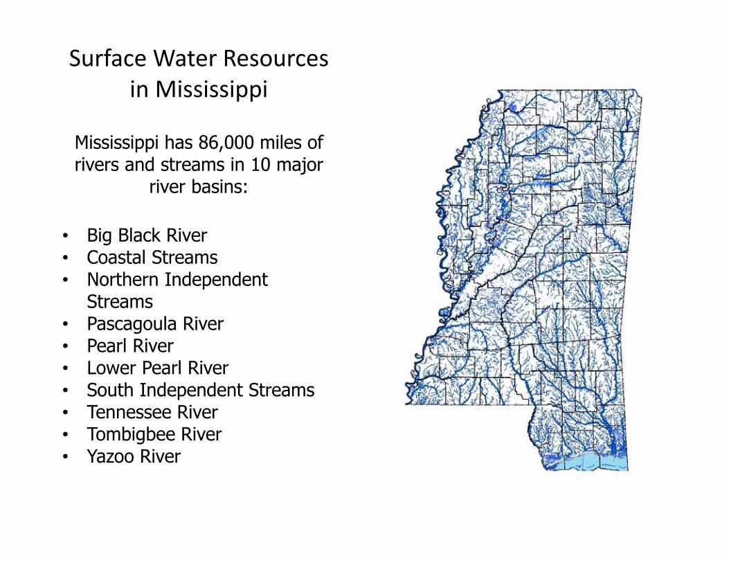
Surface Water Resources in Mississippi
Mississippi has 86,000 miles of rivers and streams in 10 major
river basins:
• Big Black River• Coastal Streams• Northern Independent
Streams• Pascagoula River• Pearl River• Lower Pearl River• South Independent Streams• Tennessee River• Tombigbee River• Yazoo River
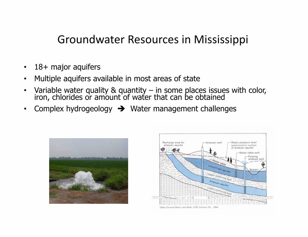
Groundwater Resources in Mississippi
• 18+ major aquifers• Multiple aquifers available in most areas of state• Variable water quality & quantity – in some places issues with color,
iron, chlorides or amount of water that can be obtained• Complex hydrogeology Water management challenges
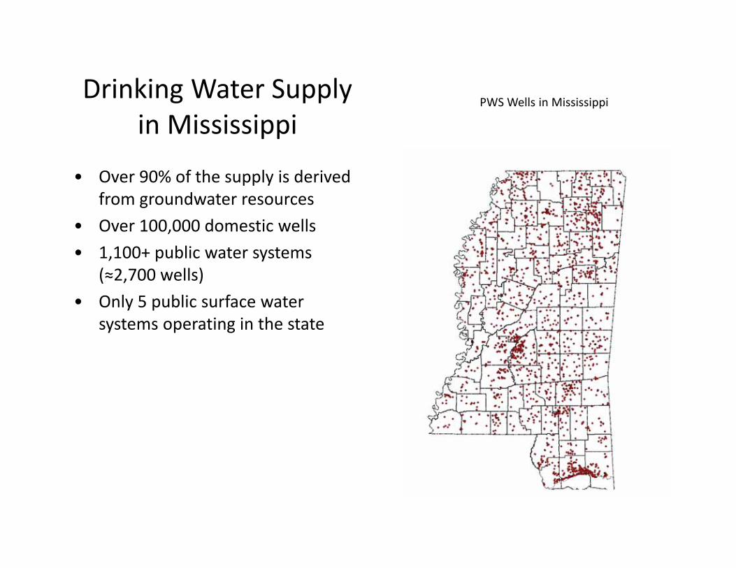
Drinking Water Supply in Mississippi
• Over 90% of the supply is derived from groundwater resources
• Over 100,000 domestic wells• 1,100+ public water systems
(≈2,700 wells)• Only 5 public surface water
systems operating in the state
PWS Wells in Mississippi

Why Groundwater versus Surface Water?
• Groundwater is more reliable during droughts• Generally, groundwater needs less treatment before use
• Drilling a well is less expensive than building a water treatment plant
• Groundwater can be tapped where it is needed, whereas surface waters are concentrated in lakes and streams
• Groundwater is less susceptible to contamination• The amount of groundwater available in Mississippi dwarfs
the amount of surface water available

Source Water Assessment Program
• In 1998, the MS Department of Health contracted with MDEQ to develop and administer the Source Water Assessment Program
• MDEQ assesses the relative susceptibility of public water supply wells to becoming contaminated using various criteria, including well construction, aquifer confinement, pumpage, and flow direction, as well as proximity to possible contaminants
• Three rankings: Higher, Moderate, and Lower Capture zone around PWS well
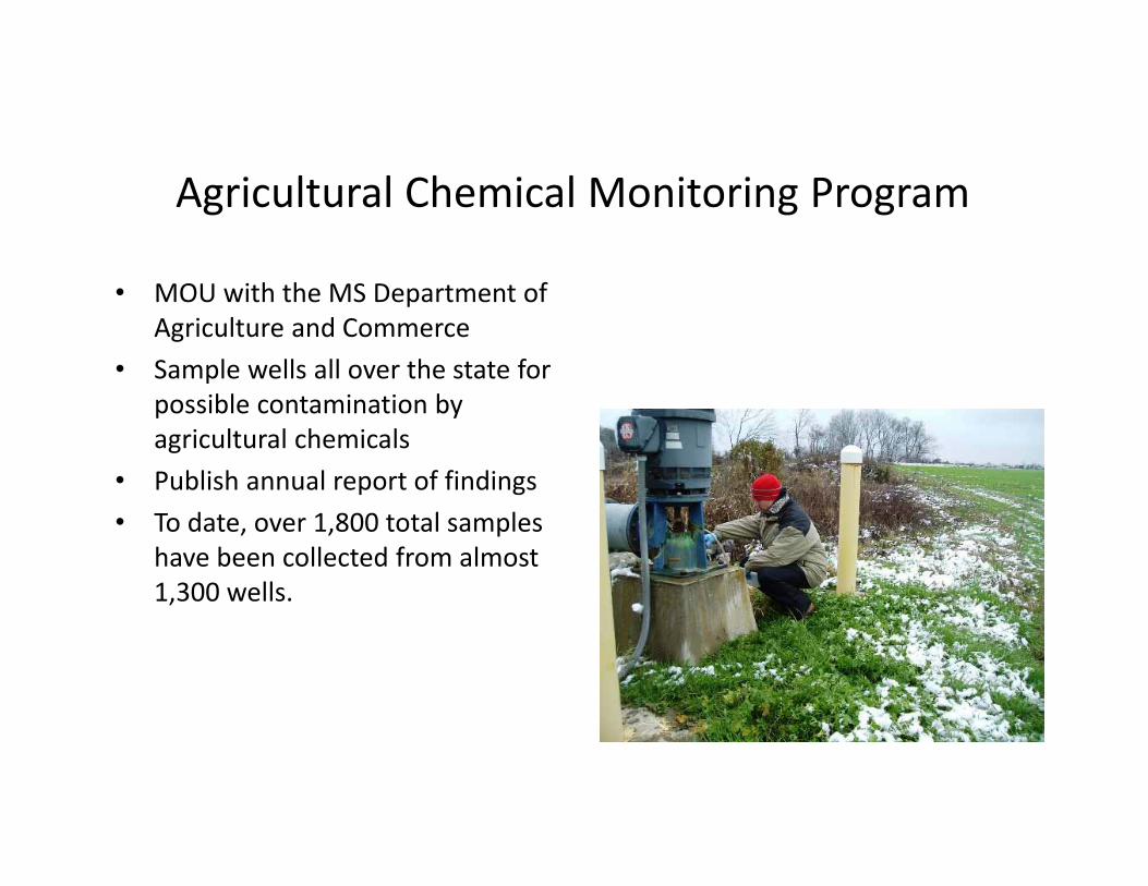
Agricultural Chemical Monitoring Program
• MOU with the MS Department of Agriculture and Commerce
• Sample wells all over the state for possible contamination by agricultural chemicals
• Publish annual report of findings• To date, over 1,800 total samples
have been collected from almost 1,300 wells.

Ambient Water Level Monitoring Network
• Plan to have two wells in each aquifer in every county
• Each well will be measured yearly
• Will add wells or remove wells from network as necessary

Areas of HydrogeologicInvestigation
South – Coastal Aquifer delineation and fracking
Central – Jackson Metro and cross sections
Delta – Alluvial aquifer declines and groundwater modelingNorth – Potentiometric maps and cross sections
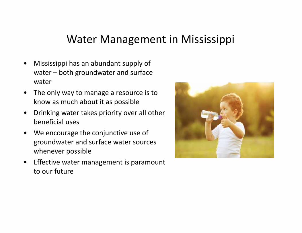
Water Management in Mississippi
• Mississippi has an abundant supply of water – both groundwater and surface water
• The only way to manage a resource is to know as much about it as possible
• Drinking water takes priority over all other beneficial uses
• We encourage the conjunctive use of groundwater and surface water sources whenever possible
• Effective water management is paramount to our future

There is a problem• Long term trend in declining
water levels in alluvial aquifer used for irrigation– Increased pumpage
• Increasing demand on groundwater
• 3,000 wells in 80’s to 19,000 wells in 2015
– Not enough being replenished• Recharge from rainfall and streams
• Inflow from Mississippi River and bluff hills
• Flow from underlying aquifers

Delta Sustainable Water Resources Task Force
Executive/Producer
Staff
MDEQ Gary Rikard Kay Whittington
MSWCC Pete Hunter Don Underwood
Delta FARM Travis Satterfield
Trey Cooke
YMD Rex Morgan Don Christy
MFB MikeMcCormick
Andy Whittington
NRCS Kurt Readus Kevin Kennedy
Delta Council George King Chip Morgan
USACE Kent Parrish

Current Efforts1. Continue to maintain focus on conservation2. Need more information on alternative water
supplies to effectively evaluate3. Comparative analysis of modeling results for
selected alternatives4. Consult with an ag economist to get cost
estimates in a comparable format5. Investigate funding options through the Task
Force Funding Committee6. Implement pilot projects and continue data
collection to improve model for future applications

Improving Information• Need better estimates of inputs and outputs to
improve model so that the Delta can make informed decisions on best suite of solutions– Inputs
• Recharge from above – USGS MAP multi year innovative data collection efforts to better
characterize topstratum and improve modeling of Soil Water Balance• Exchange from below
– MDEQ is monitoring paired wells and evaluating geophysical logs to better define areas of connection
– Outputs• Trend in wrong direction and more is being pumped out than is being recharged
• Voluntary metering is critical to more accurately represent geographic distribution of pumpage

Permitting, Certification & Compliance
• Permitting Branch– Permit all Water Withdrawals Statewide• Groundwater• Surface Water
• Certification and Compliance Branch– Compliance and Enforcement– License and Regulate Well Drillers
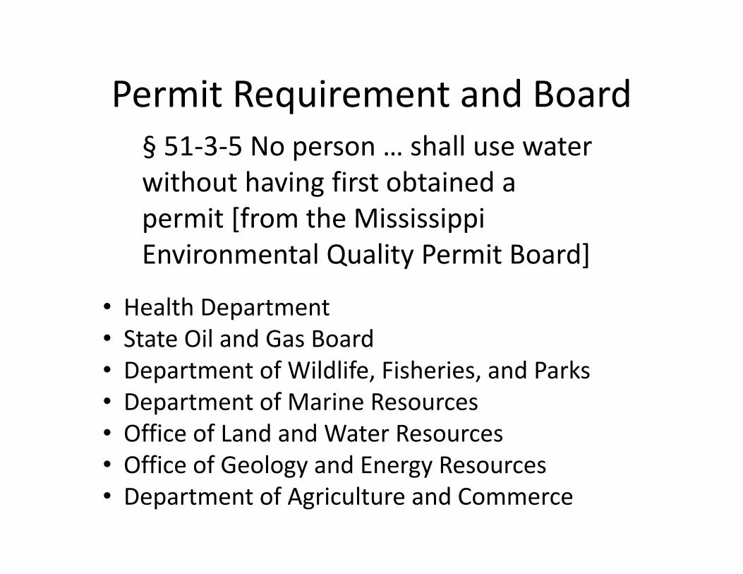
Permit Requirement and Board§ 51‐3‐5 No person … shall use water without having first obtained a permit [from the Mississippi Environmental Quality Permit Board]
• Health Department• State Oil and Gas Board• Department of Wildlife, Fisheries, and Parks• Department of Marine Resources• Office of Land and Water Resources• Office of Geology and Energy Resources• Department of Agriculture and Commerce
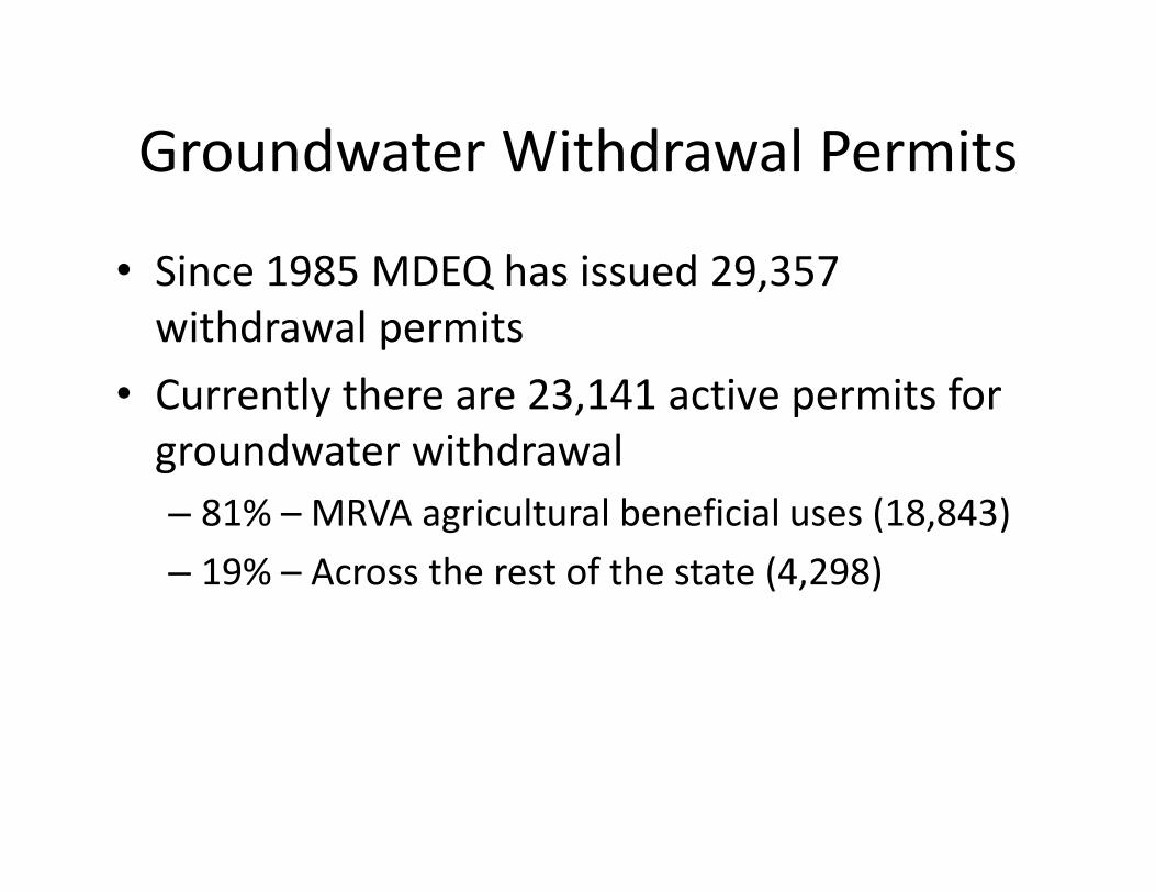
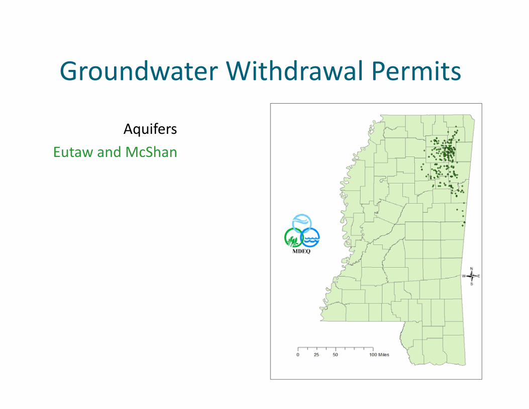
Groundwater Withdrawal Permits
• Since 1985 MDEQ has issued 29,357 withdrawal permits
• Currently there are 23,141 active permits for groundwater withdrawal– 81% – MRVA agricultural beneficial uses (18,843) – 19% – Across the rest of the state (4,298)
Groundwater Withdrawal Permits
AquifersEutaw and McShan

Groundwater Withdrawal Permits
AquifersEutaw and McShan Gordo

Groundwater Withdrawal Permits
AquifersEutaw and McShan Gordo Wilcox Group

Groundwater Withdrawal Permits
AquifersEutaw and McShan Gordo Wilcox GroupMeridian Upper Wilcox

Groundwater Withdrawal Permits
AquifersEutaw and McShan GordoWilcox GroupMeridian Upper WilcoxSparta
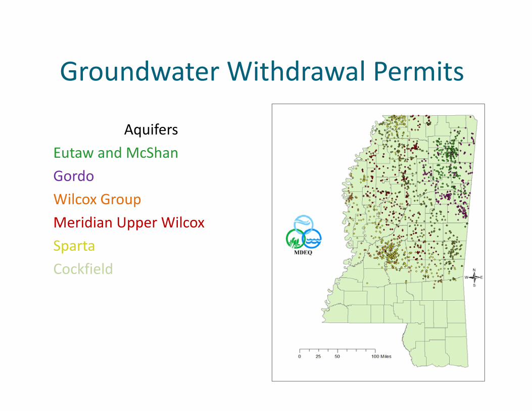
Groundwater Withdrawal Permits
AquifersEutaw and McShan GordoWilcox GroupMeridian Upper WilcoxSparta Cockfield
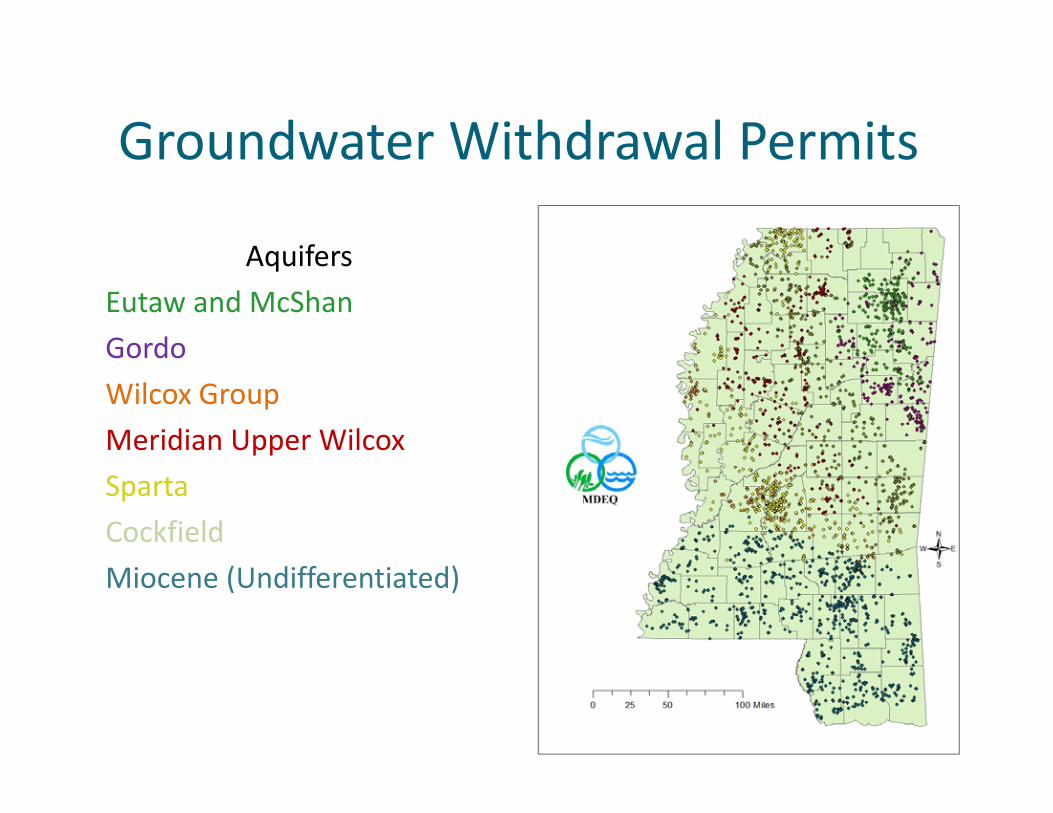
Groundwater Withdrawal Permits
AquifersEutaw and McShan GordoWilcox GroupMeridian Upper WilcoxSparta CockfieldMiocene (Undifferentiated)

Groundwater Withdrawal Permits
AquifersEutaw and McShan GordoWilcox GroupMeridian Upper WilcoxSparta CockfieldMiocene (Undifferentiated)Graham Ferry
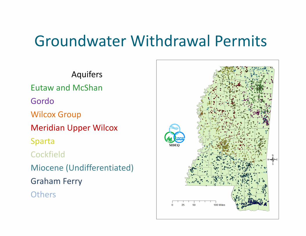
Groundwater Withdrawal Permits
AquifersEutaw and McShan Gordo Wilcox GroupMeridian Upper WilcoxSparta CockfieldMiocene (Undifferentiated)Graham FerryOthers

Groundwater Withdrawal Permits
AquifersEutaw and McShan Gordo Wilcox GroupMeridian Upper WilcoxSparta CockfieldMiocene (Undifferentiated)Graham FerryOthersMS River Valley Alluvial

Surface Water Withdrawal/Diversion Permits
• There are 2,549 active surface water withdrawal permits– 1,725 –Delta Agriculture Irrigation– 802 – Throughout the rest of the state

Surface Water Withdrawal/Diversion Permits
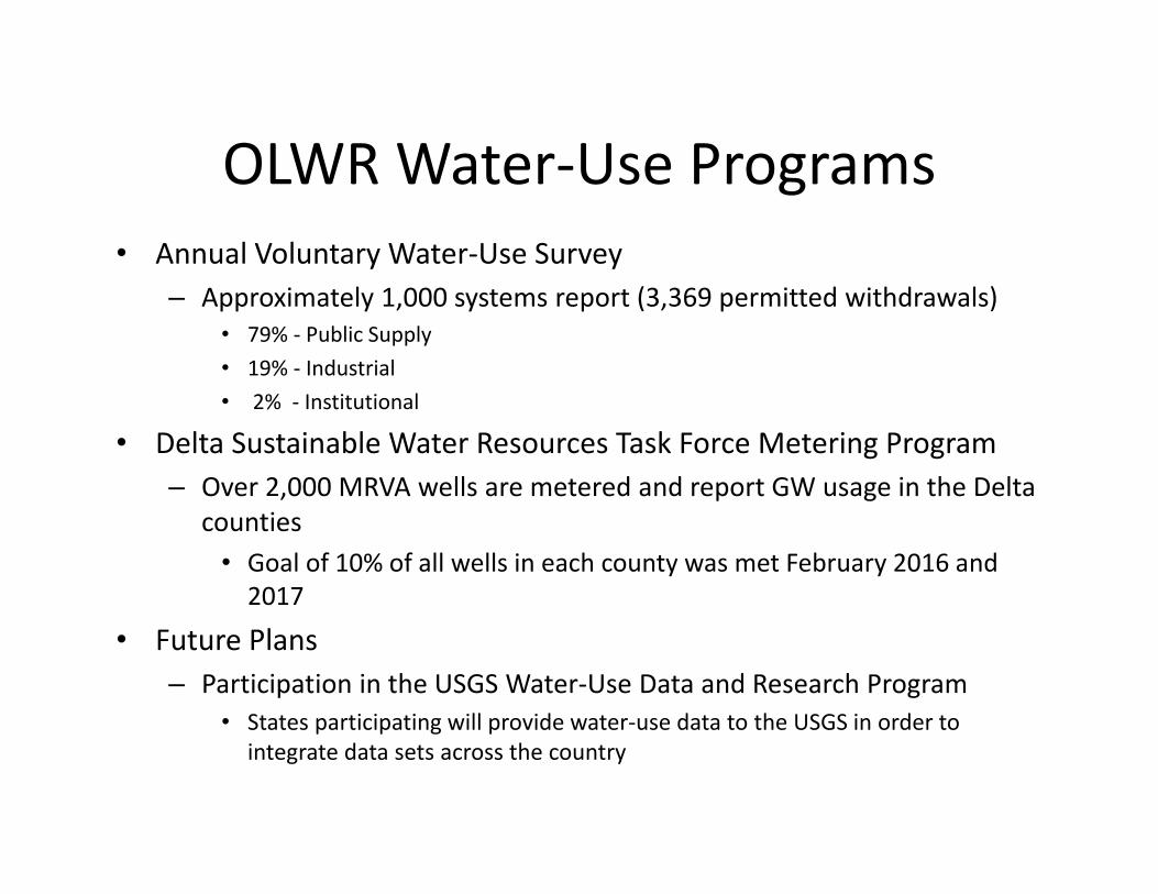
OLWR Water‐Use Programs • Annual Voluntary Water‐Use Survey
– Approximately 1,000 systems report (3,369 permitted withdrawals)• 79% ‐ Public Supply• 19% ‐ Industrial• 2% ‐ Institutional
• Delta Sustainable Water Resources Task Force Metering Program– Over 2,000 MRVA wells are metered and report GW usage in the Delta
counties• Goal of 10% of all wells in each county was met February 2016 and 2017
• Future Plans– Participation in the USGS Water‐Use Data and Research Program
• States participating will provide water‐use data to the USGS in order to integrate data sets across the country

Dam Safety
– Impoundments also an important use of water in MS, but must be done safely• Flood control, recreation
– Issue permits for dam construction and repair and impoundment of surface water
– Assign Hazard Classification Based on Potential Loss of Life and/or Property
– Develop and Administer Emergency Action Plans
– Respond to Emergency Dam Incidents and Failures
– Perform Breaching of Unsafe Dams

Overview of Statutes, Regulations, and
Programs Related to Water Quality Statewide

Office of Pollution Control
Env Compliance and Enforce Division
Env Permits Division
Field Services Division
Surface Water Division
Ground Water Assessment and Remediation
Division
Air Division
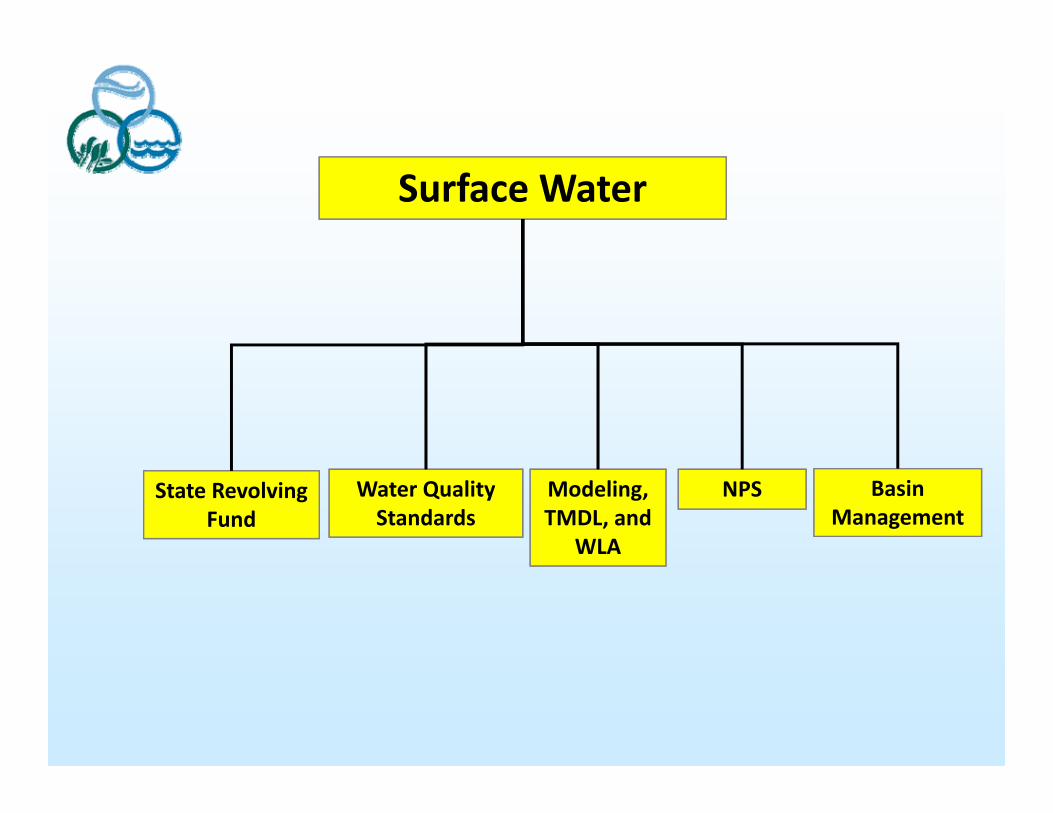
Surface Water
Basin Management
NPSModeling, TMDL, and
WLA
Water Quality Standards
State Revolving Fund
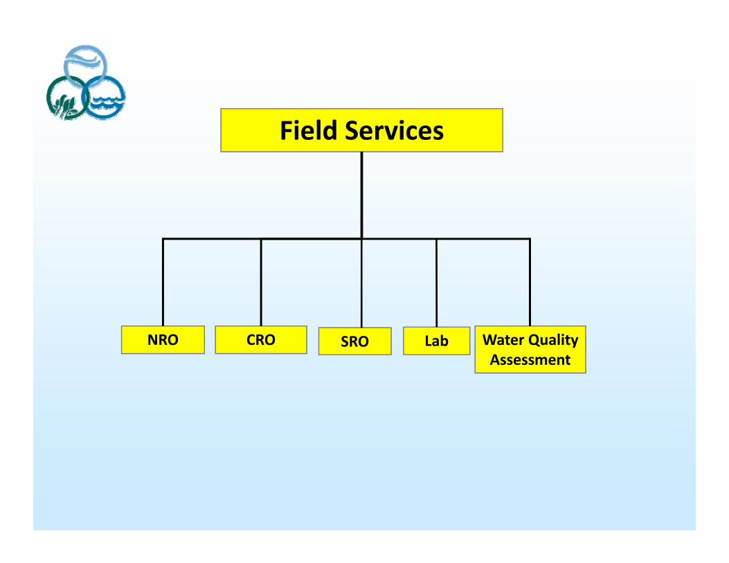
Field Services
Water Quality Assessment
LabCRONRO SRO
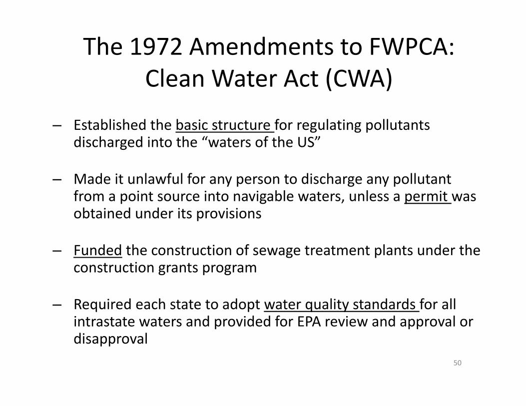
The 1972 Amendments to FWPCA: Clean Water Act (CWA)
– Established the basic structure for regulating pollutants discharged into the “waters of the US”
– Made it unlawful for any person to discharge any pollutant from a point source into navigable waters, unless a permit was obtained under its provisions
– Funded the construction of sewage treatment plants under the construction grants program
– Required each state to adopt water quality standards for all intrastate waters and provided for EPA review and approval or disapproval
50

Why?
51
Cleveland Mayor Carl Stokes on the banks of the Cuyahoga, 1969
Cleveland’s Cuyahoga River on fire, 1969
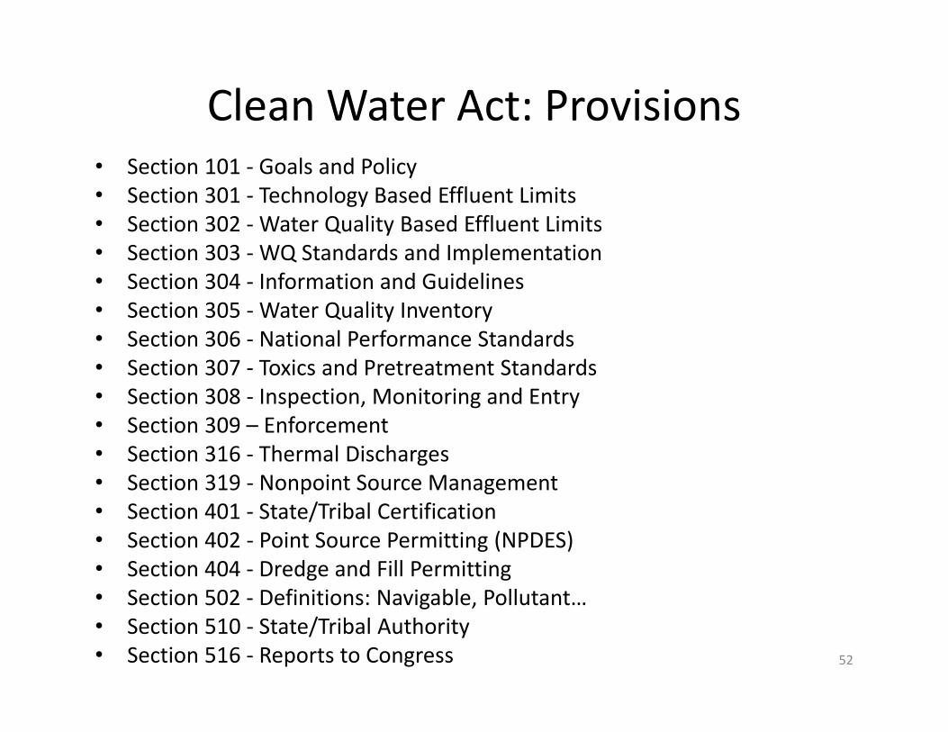
Clean Water Act: Provisions• Section 101 ‐ Goals and Policy• Section 301 ‐ Technology Based Effluent Limits• Section 302 ‐ Water Quality Based Effluent Limits• Section 303 ‐ WQ Standards and Implementation• Section 304 ‐ Information and Guidelines• Section 305 ‐ Water Quality Inventory• Section 306 ‐ National Performance Standards• Section 307 ‐ Toxics and Pretreatment Standards• Section 308 ‐ Inspection, Monitoring and Entry• Section 309 – Enforcement• Section 316 ‐ Thermal Discharges• Section 319 ‐ Nonpoint Source Management• Section 401 ‐ State/Tribal Certification• Section 402 ‐ Point Source Permitting (NPDES)• Section 404 ‐ Dredge and Fill Permitting• Section 502 ‐ Definitions: Navigable, Pollutant…• Section 510 ‐ State/Tribal Authority• Section 516 ‐ Reports to Congress 52

CWA Provisions Establish a Water Quality Based Approach
53
DevelopTMDLs
ImplementTMDLs
MonitorResults
ConductMonitoring andAssessment
WQSWritePermits
IdentifyImpairedWaters

Water Quality Standards (WQS)
54
DevelopTMDLs
ImplementTMDLs
MonitorResults
ConductMonitoring andAssessment
WQSWritePermits
IdentifyImpairedWaters
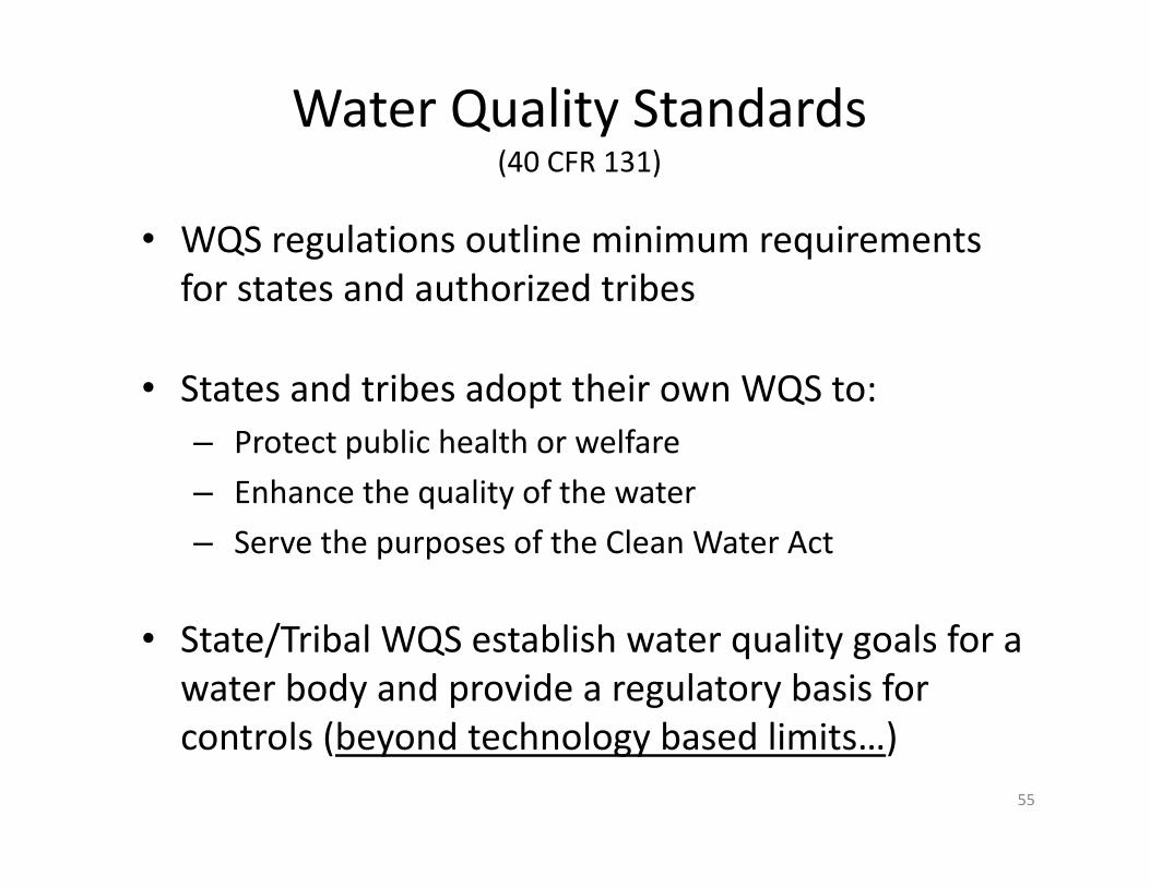
Water Quality Standards(40 CFR 131)
• WQS regulations outline minimum requirements for states and authorized tribes
• States and tribes adopt their own WQS to:– Protect public health or welfare– Enhance the quality of the water– Serve the purposes of the Clean Water Act
• State/Tribal WQS establish water quality goals for a water body and provide a regulatory basis for controls (beyond technology based limits…)
55

3 Components of WQS
• Designated Uses
• Water Quality Criteria (Narrative or Numeric)
• Antidegradation Policy
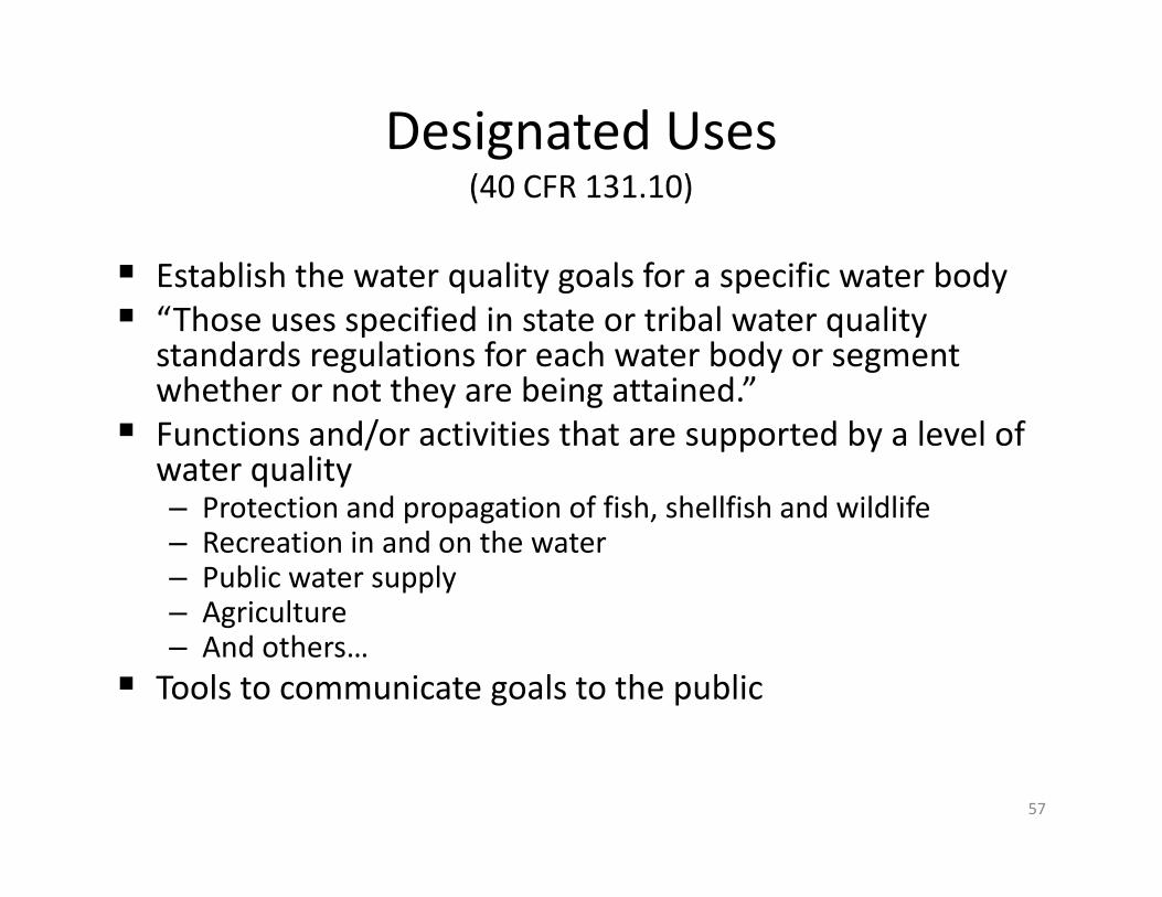
Designated Uses(40 CFR 131.10)
Establish the water quality goals for a specific water body “Those uses specified in state or tribal water quality
standards regulations for each water body or segment whether or not they are being attained.”
Functions and/or activities that are supported by a level of water quality– Protection and propagation of fish, shellfish and wildlife– Recreation in and on the water– Public water supply– Agriculture– And others…
Tools to communicate goals to the public
57
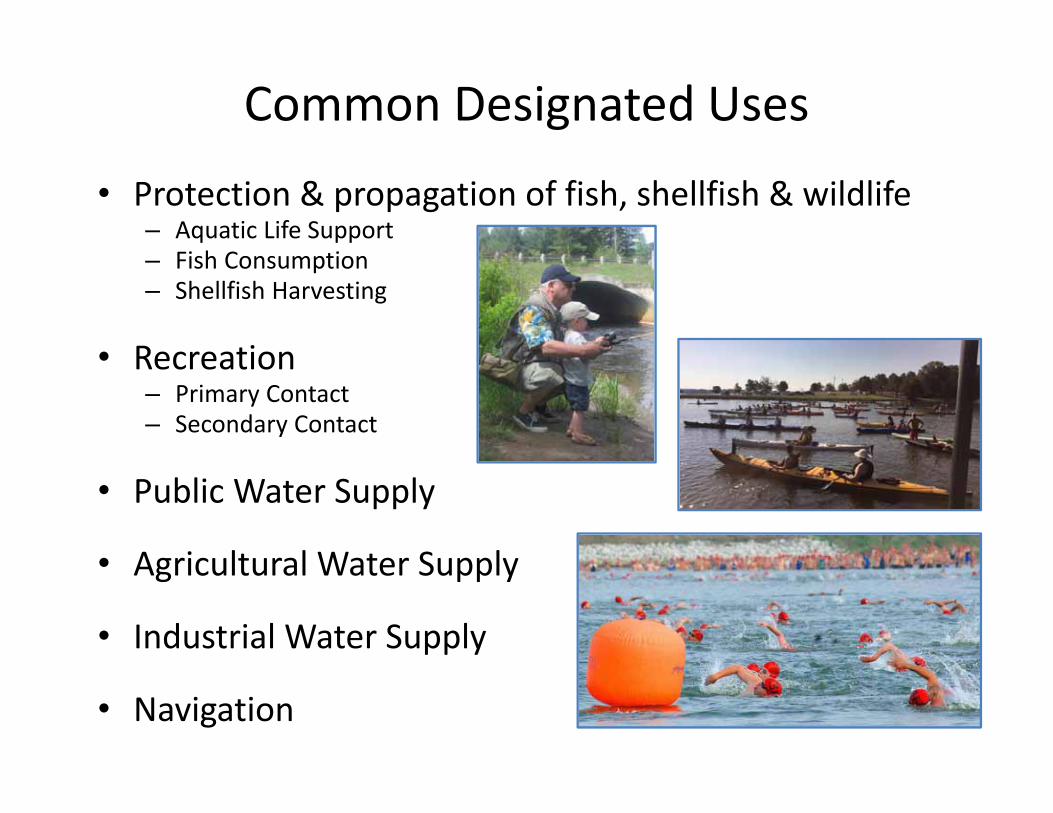
Common Designated Uses
• Protection & propagation of fish, shellfish & wildlife– Aquatic Life Support– Fish Consumption– Shellfish Harvesting
• Recreation– Primary Contact– Secondary Contact
• Public Water Supply
• Agricultural Water Supply
• Industrial Water Supply
• Navigation

Classifications vs. Designated Uses
MS Water BodyClassification
U.S. EPA AssociatedDesignated Use
Fish and WildlifeAquatic Life UseFish ConsumptionSecondary Contact Recreation
Public Water Supply Drinking Water Supply
Recreation Primary Contact Recreation
Shellfish Harvesting Shellfish Consumption
Ephemeral Streams NA

Water Quality Criteria
• A concentration, level, or narrative statement
• Represent a level of water quality that supports a particular designated use
• States must adopt criteria that protect the designated use(s)– Based on a sound, scientific rationale– Sufficient parameters to protect the designated use– Must support the most sensitive use

Types of Water Quality Criteria
To protect aquatic life uses– Aquatic life criteria (focus on chemical parameters)– Biological criteria (focus on aquatic community)– Nutrient criteria (focus on aquatic community)
To protect human uses– Human health criteria (focus on effects over a lifetime)– Recreational criteria (focus on preventing acute illness from recreation or flow needed for recreation)
– Nutrient criteria (focus on human or aesthetic impacts)
61
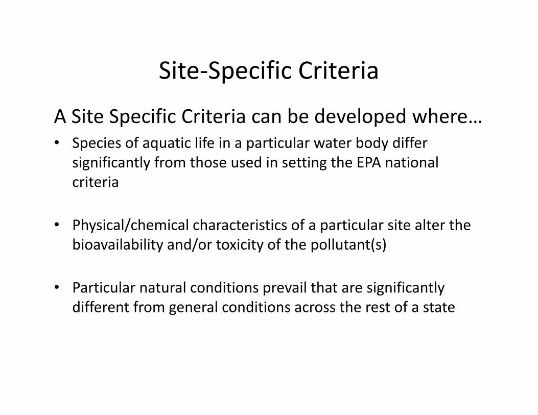
Site‐Specific Criteria
A Site Specific Criteria can be developed where…• Species of aquatic life in a particular water body differ
significantly from those used in setting the EPA national criteria
• Physical/chemical characteristics of a particular site alter the bioavailability and/or toxicity of the pollutant(s)
• Particular natural conditions prevail that are significantly different from general conditions across the rest of a state

Antidegradation
Prevent deterioration of existing levels of good (or better) water quality
Two basic rules apply to all high quality waters
• If better than it has to be, then it should stay that way with limited exception
• Use of assimilative capacity is not an automatic right, a process must be used to determine if the use of a water’s assimilative capacity is necessary
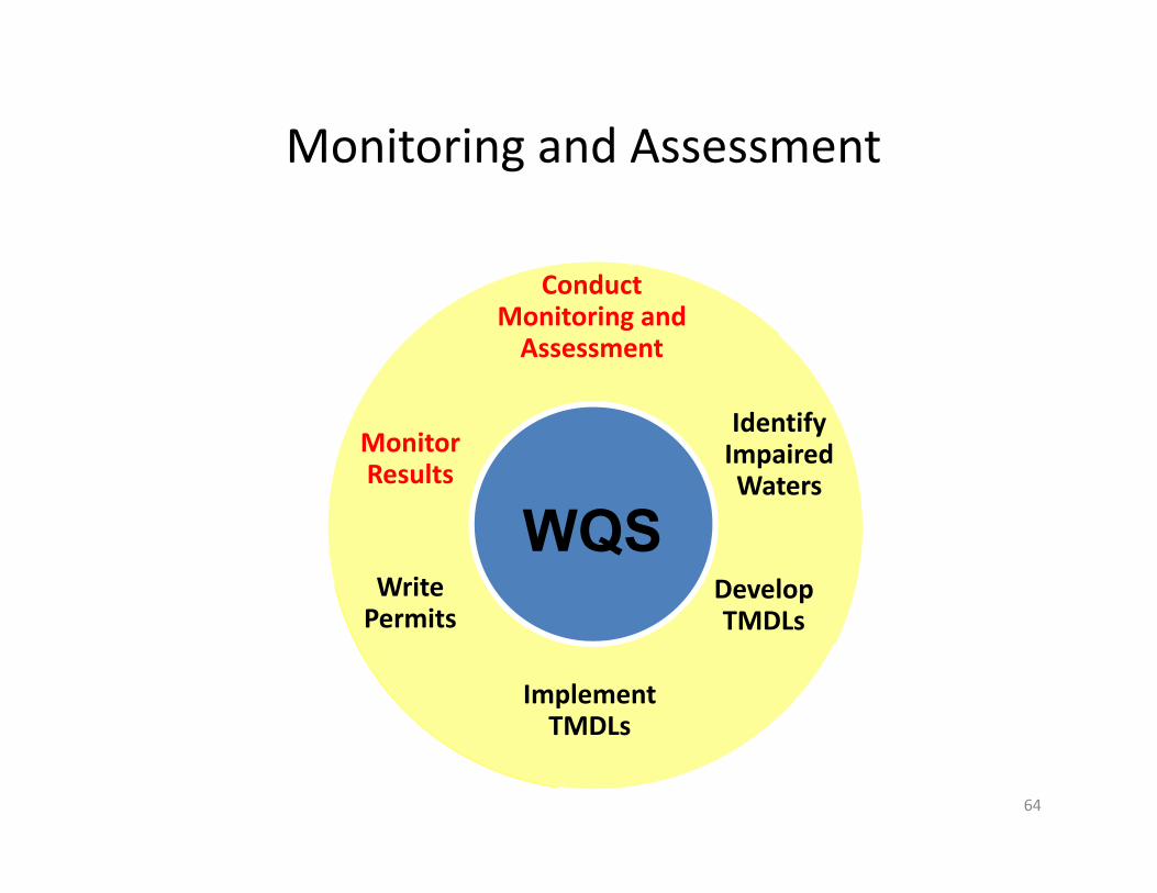
Monitoring and Assessment
64
DevelopTMDLs
ImplementTMDLs
MonitorResults
ConductMonitoring andAssessment
WQSWritePermits
IdentifyImpairedWaters
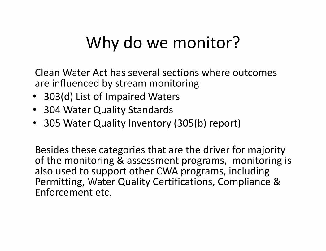
Why do we monitor?Clean Water Act has several sections where outcomes are influenced by stream monitoring• 303(d) List of Impaired Waters• 304 Water Quality Standards• 305 Water Quality Inventory (305(b) report)
Besides these categories that are the driver for majority of the monitoring & assessment programs, monitoring is also used to support other CWA programs, including Permitting, Water Quality Certifications, Compliance & Enforcement etc.

Statewide Ambient Program
• Designed to answer Clean Water Act & State Questions– Status of the states waters (305)– List of Impaired Waters (303)–Water Quality Standards development (304)
• Measuring Success of CWA programs• Used in Water Quality Assessment tool development

How Monitoring Data Are Used
303(d) listing
Stressor identification
Permitting and/or 319
Watershed improvements
Ambient monitoring
305(b) assessment
compliance schedules and monitoring

Water Chemistry Data
• Compared to water quality criteria to determine use attainment
• Examples of parameters with numeric criteria: – Pathogens– Dissolved oxygen– Temperature– pH
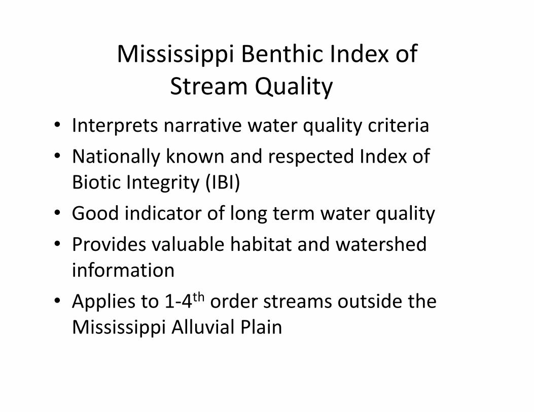
Mississippi Benthic Index of Stream Quality
• Interprets narrative water quality criteria• Nationally known and respected Index of Biotic Integrity (IBI)
• Good indicator of long term water quality• Provides valuable habitat and watershed information
• Applies to 1‐4th order streams outside the Mississippi Alluvial Plain

305(b) Assessments
• The state is required under the CWA section 305(b) to report the “status of the state’s waters”
• Monitoring data are used to make attainment decisions• Is the waterbody “meeting its use”?
– Designated use is the use we expect the waterbody to maintain. In this case is “Aquatic Life Use Support” under the “Fish and Wildlife Classification”
– Fish and Wildlife: “intended for fishing and for propagation of fish, aquatic life, and wildlife.”
• Yes – attaining the use• No – not attaining the use ‐303d list‐TMDL/319 etc

Impaired Waters
71
DevelopTMDLs
ImplementTMDLs
MonitorResults
ConductMonitoring andAssessment
WQSWritePermits
IdentifyImpairedWaters

Monitoring and Assessing Waters Are They “Impaired”?
• The National Water Quality Inventory Report to Congress (305(b) report) characterizes our water quality for Congress and the public:– Documents assessment methodology.– Categorizes all state waters based on WQS attainment
status• ‘impaired’ waters are listed on the ‘303(d) list’)
– Identifies Total Maximum Daily Load (TMDL) development needs
72

TMDL Development
73
DevelopTMDLs
ImplementTMDLs
MonitorResults
ConductMonitoring andAssessment
WQSWritePermits
IdentifyImpairedWaters
Restoring Waters: TMDLs
• When a state or tribe assesses a water and finds that it is not attaining WQS, it lists the water as “impaired” on its 303(d) list.
• The goal is to restore the water quality (CWA)• Total Maximum Daily Load (TMDL) is like a “pollution diet”
for “impaired” waters.• A TMDL is a calculation of the maximum amount of a
pollutant that a water body can receive and still safely meet WQS.
• TMDLs are water body – pollutant specific– Organic Enrichment, Nutrients, Sediment, Pathogens, Mercury,
pH, Pesticides
74

TMDL = WLA + LA + MOSTMDL = WLA + LA + MOS
Point Source
Margin of Safety
Non-Point Source
Non-PointSource
Point Source
Margin ofSafety

What activities impact water quality? • ‘Point source’ discharges generally must be regulated in a
manner consistent with state/tribal WQS. Per CWA 502(14), point sources are “any discernable, confined and discrete conveyance including…any pipe, ditch, channel…[etc] from which pollutants are or may be discharged.”
• Examples:– National Pollutant Discharge Elimination System permits to discharge
pollutants from a point source into waters of the U.S. (NPDES, from CWA 402 authority)
– Permits for operations that may result in discharge of dredged or fill material to waters of the U.S. (from CWA 404 authority)
– Permits or licenses for federal facilities that may result in discharge to waters of the U.S. (from CWA 401 authority)
• ‘Nonpoint source’ discharges (NPS) are a major source, but regulation is at the discretion of states and tribes.
76

Implementing TMDLs
77
DevelopTMDLs
ImplementTMDLs
MonitorResults
ConductMonitoring andAssessment
WQS319 (NPS)
IdentifyImpairedWaters
Reduce Point Sources (WLA) and/orNonpoint Sources (LA) (as needed)
Permitting
WLAs – Point Sources and Permit Limits
• WLAs based on TMDLs• WLAs for routine permitting
NPDES Program
• National Pollutant Discharge Elimination System (NPDES) permits grant permission to discharge pollutants to a water of the U.S. from a point source. (Per CWA 402).
• Permits are issued by an authorized state/tribe (or EPA if the state/tribe is not authorized).
• Permits contain numeric and narrative limitsfor the pollutants to be discharged.
79
TMDL related WLAs
WLAs sets effluent limits for the pollutants defined in the TMDL The TMDL specifies which NPDES permits in the watershed are subject to permit limits The TMDL may specify other permit conditions
80
WLAs for NPDES Permits
In MS all Municipal and Commercial NPDES Permits require Water Quality Based Effluent Limits (WQBELs) All Municipal and Commercial NPDES Discharges are modeled to determine WQBELs All DO related effluent limitations are determined by water quality modeling
81
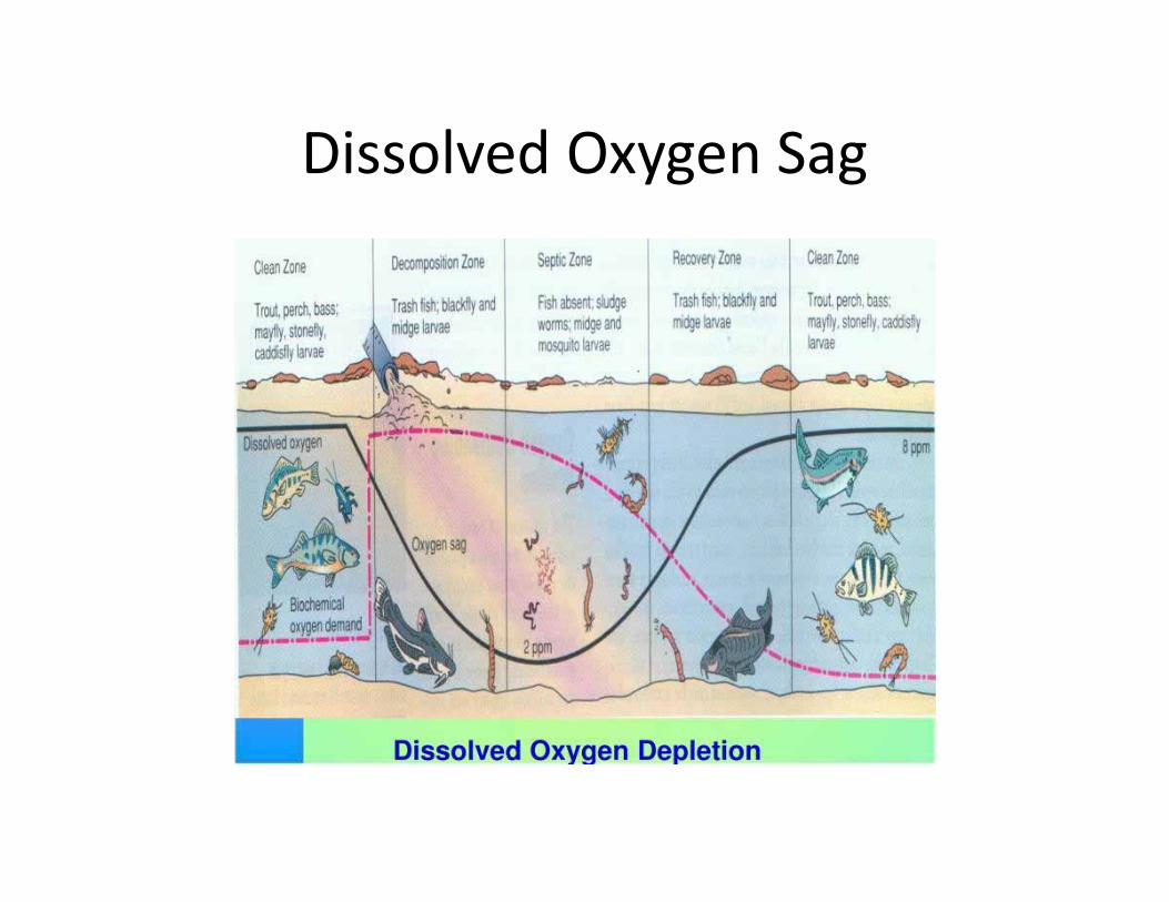
Dissolved Oxygen Sag

Implementing TMDLs
83
DevelopTMDLs
ImplementTMDLs
MonitorResults
ConductMonitoring andAssessment
WQS319 (NPS)
IdentifyImpairedWaters
Permitting

What is Nonpoint Source (NPS) Pollution?
• “Polluted runoff” – rain or snowmelt carries natural and anthropogenic pollutants to waters
• Any source of water pollution that does NOT meet the legal definition of “point source” in CWA 502(14). NPS include many sources, e.g.,:– agricultural storm water discharges– return flows from irrigated agriculture
84

How do we control NPS pollution? • States and tribes have discretion on whether and how to
regulate NPS, and how they implement their WQS for NPS.
• Many government programs are available to assist:– Over 40% of CWA section 319 grants have been used to control
NPS pollution from working farms and ranches. – Programs funded by the U.S. Department of Agriculture and by
states provide cost‐share, technical assistance, and economic incentives to implement NPS pollution management practices.
– Local organizations have helped create regional support networks to adopt technologies and practices to eliminate or reduce water quality impacts caused by agricultural activities.
85
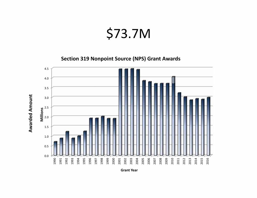
$73.7M
0.0
0.5
1.0
1.5
2.0
2.5
3.0
3.5
4.0
4.5
1990
1991
1992
1993
1994
1995
1996
1997
1998
1999
2000
2001
2002
2003
2004
2005
2006
2007
2008
2009
2010
2011
2012
2013
2014
2015
2016
Awarde
d Am
ount
Millions
Grant Year
Section 319 Nonpoint Source (NPS) Grant Awards

Agriculture
Animals in stream beds as well as runoff from fields add pollutants to surface waters.
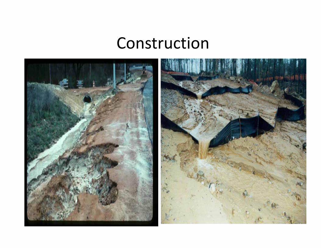
Construction

Silviculture

Urban Stormwater
Litter and debris as well as oil and other car fluids contribute to the pollution of urban stormwater.

Mining

Hydro‐modifications
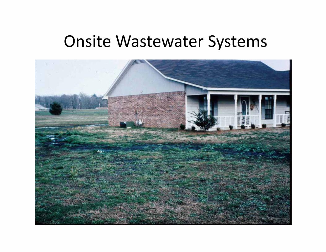
Onsite Wastewater Systems
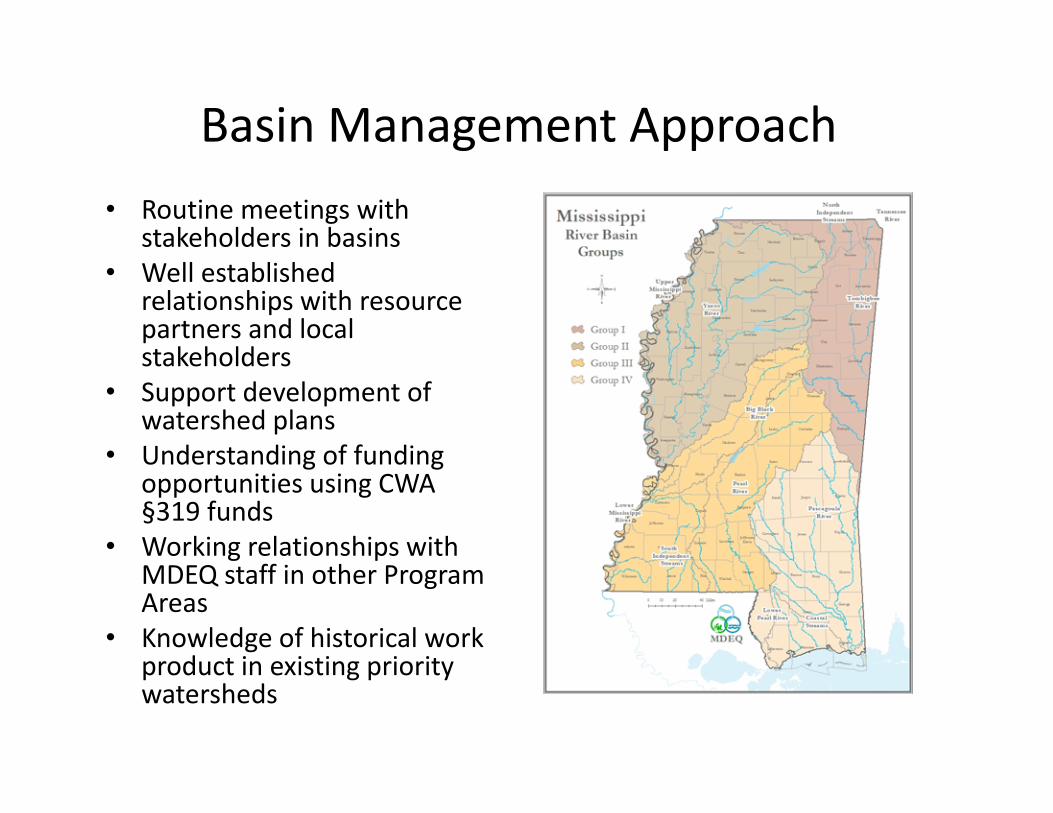
Basin Management Approach• Routine meetings with
stakeholders in basins• Well established
relationships with resource partners and local stakeholders
• Support development of watershed plans
• Understanding of funding opportunities using CWA §319 funds
• Working relationships with MDEQ staff in other Program Areas
• Knowledge of historical work product in existing priority watersheds

Planning with Vision• Inter‐program
coordination of watershed activities
• Coordination with resource partners and stakeholders
• Stakeholder Involvement with Watershed Selection
• Use existing relationships to support activities
• Develop Watershed Plans to address WQ Concerns
• Support contractual, reporting, planning needs for priority watershed
Watershed Planning
§303(d)
Point Source
Nonpoint Source
MonitoringResource Partners
Assessment
Stakeholders

The Basin Management Approach…
• Identifies and prioritizes water quality issues of concern• Identifies and encourages collaboration and leveraging
opportunities• Seeks solutions at the local level• Seeks measurable benefits• Focuses on Success

Summary• MDEQ regulates water
quantity and quality
• Research is an important part of developing innovative solutions to our water challenges
• Help set research priorities through WRRI board
• Communication and coordination key