tibetans in wakhan: new information on...
TRANSCRIPT
John Mock, “Tibetans in Wakhan: New Information on Inscriptions and Rock Art”, Revue d’Etudes Tibétaines, no. 36, October 2016, pp. 121-141.
Tibetans in Wakhan: New Information on Inscriptions and Rock Art
John Mock
(Independent Scholar)
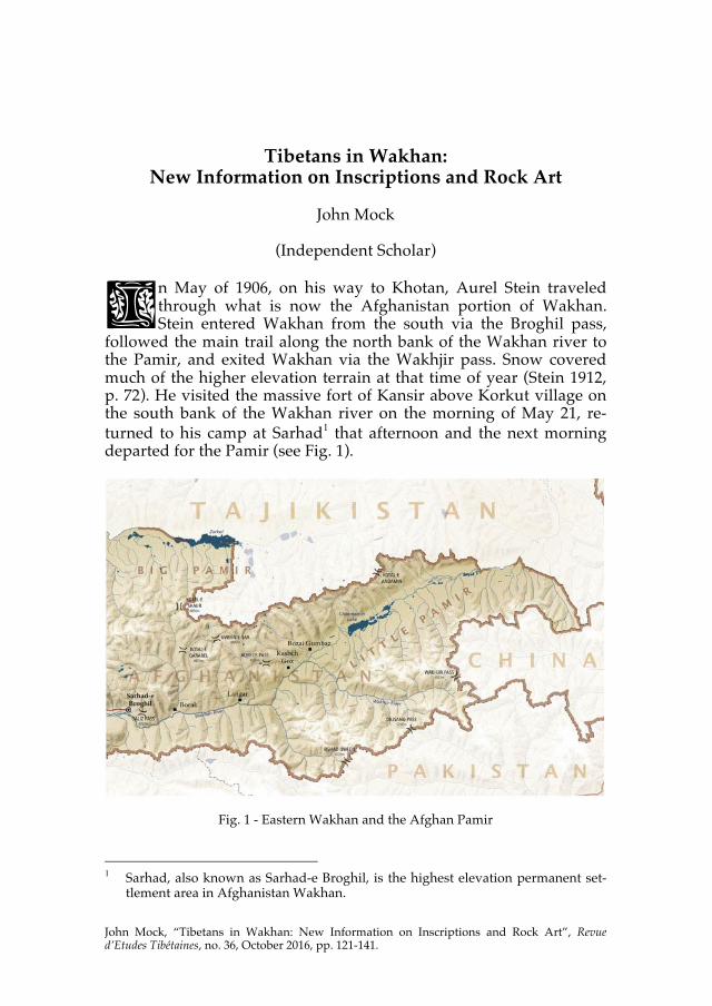
n May of 1906, on his way to Khotan, Aurel Stein traveled through what is now the Afghanistan portion of Wakhan. Stein entered Wakhan from the south via the Broghil pass,
followed the main trail along the north bank of the Wakhan river to the Pamir, and exited Wakhan via the Wakhjir pass. Snow covered much of the higher elevation terrain at that time of year (Stein 1912, p. 72). He visited the massive fort of Kansir above Korkut village on the south bank of the Wakhan river on the morning of May 21, re-turned to his camp at Sarhad1 that afternoon and the next morning departed for the Pamir (see Fig. 1).
Fig. 1 - Eastern Wakhan and the Afghan Pamir
1 Sarhad, also known as Sarhad-e Broghil, is the highest elevation permanent set-
tlement area in Afghanistan Wakhan.
I

Revue d’Etudes Tibétaines 122
Stein’s understanding of Wakhan’s history was “derived solely” from Édouard Chavannes’ French translation of the Tang dynasty annals (Stein 1922, p.133; Chavannes 1903/2006a). Recent scholarship has contributed substantially to our understanding of the history of Wakhan and the Pamir region in the 7th-9th centuries CE. The Tang dynasty annals have been reexamined and compared with other im-portant Chinese sources, the Old Tibetan Annals, the Old Tibetan Chronicle, Old Turkic inscriptions, and Arabic sources.2
Stein’s main interest in Wakhan was the Chinese campaign of 747 CE, in which General Kao Hsien-chih led an army of 10,000 cavalry and infantry across the Pamir and defeated a Tibetan army at Lien-Yün, a fortified place close to present-day Sarhad-e Broghil. Stein noted that a principal Chinese objective in the Pamir was “control of the great Central Asian trade route” (Stein 1922, p. 114), and Kao Hsien-chih’s military campaign was the culmination of decades of struggle with the Tibetan empire for control of the Pamir route(s).
The Tang court maintained diplomatic relations with the inde-pendent kingdoms of Wakhan, Balur/Palola,3 Chitral and Kashmir, which sent emissaries bearing tribute to the court. Despite these trade and diplomatic missions to the Tang court and the Chinese granting official decrees awarding royal titles to the kings, the Tibetans con-tinued to pass through Balur and Wakhan.4 In 722 CE, the Tibetan army occupied Little Balur, provoking a military response from the Chinese,5 who defeated the Tibetans in Balur the same year (Beck-with 1987, p. 95). The Tibetans, however, did not go away and in 730 CE the king of Wakhan fled to Chinese territory where he requested military aid to counter Tibetan influence (Beckwith 1987, p. 111). Fi-nally, in 737 CE, the Tibetan army captured the king of Little Balur, the entire Pamir region came under the control of Tibet, and all trib-ute to the Tang court ceased (Beckwith 1987, p. 116).
2 The ground-breaking study is Beckwith 1987. See also recent scholarship by
Denwood (2007, 2008, 2009), which proposes new interpretations, and Zeisler (2009) which reviews and discusses the scholarship and sources. Dotson (2009) has provided a new and annotated translation of the Old Tibetan Annals.
3 von Hinüber (2004, p. 7) notes that Palola is also a geographic name. 4 Balur and Wakhan, along with neighboring Chitral, Uddyana and Kashmir, re-
mained aligned with China, notwithstanding significant Tibetan influence in the region (Beckwith 1987, p. 87-89; Denwood 2009, p. 152). The Tang court even sent an ambassador to Little Balur in 720 CE to confer the title of king on Su-lin-toi-chih (Surendraditya) (Chavannes 2006b, p. 42).
5 On learning of the Tibetan occupation of Balur, the Chinese Imperial Commis-sioner said: “Balur is the western gate of Tang; if Balur is lost, then the lands of the West will become all Tibetan” (Chavannes 2006a, p. 182, n. 5, my translation).
Tibetans in Wakhan
123
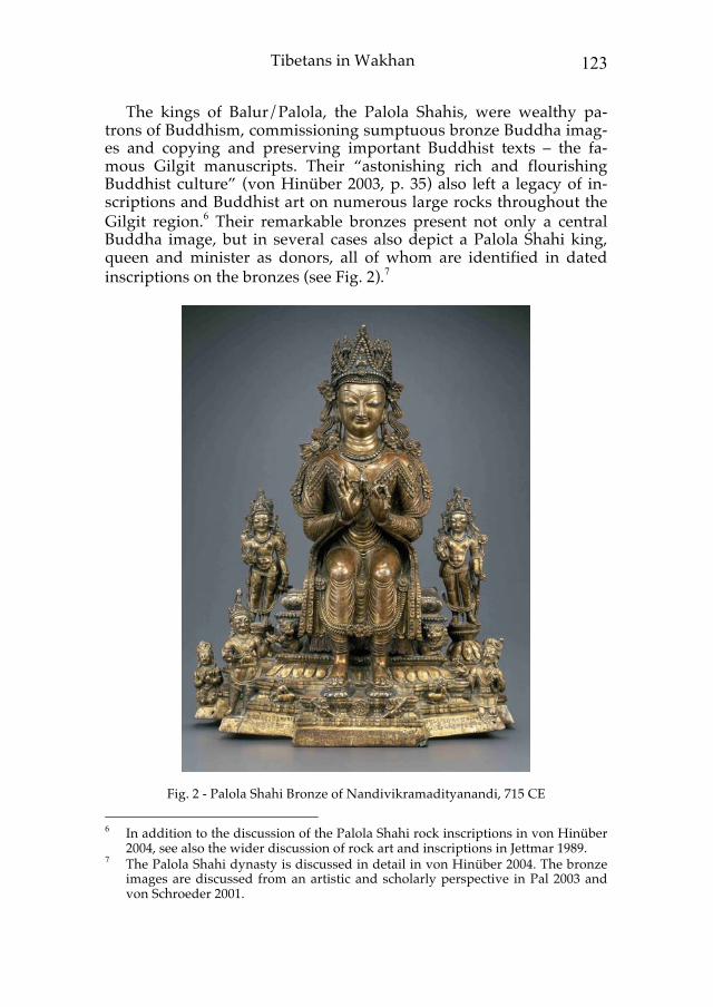
The kings of Balur/Palola, the Palola Shahis, were wealthy pa-trons of Buddhism, commissioning sumptuous bronze Buddha imag-es and copying and preserving important Buddhist texts – the fa-mous Gilgit manuscripts. Their “astonishing rich and flourishing Buddhist culture” (von Hinüber 2003, p. 35) also left a legacy of in-scriptions and Buddhist art on numerous large rocks throughout the Gilgit region.6 Their remarkable bronzes present not only a central Buddha image, but in several cases also depict a Palola Shahi king, queen and minister as donors, all of whom are identified in dated inscriptions on the bronzes (see Fig. 2).7
Fig. 2 - Palola Shahi Bronze of Nandivikramadityanandi, 715 CE 6 In addition to the discussion of the Palola Shahi rock inscriptions in von Hinüber
2004, see also the wider discussion of rock art and inscriptions in Jettmar 1989. 7 The Palola Shahi dynasty is discussed in detail in von Hinüber 2004. The bronze
images are discussed from an artistic and scholarly perspective in Pal 2003 and von Schroeder 2001.
Revue d’Etudes Tibétaines 124
Although the Palola Shahi dynasty was “unknown to ancient Indian historiography” (von Hinüber 2003, p. 36), the cultural and political significance of Balur for the Tang court seems undeniable. Nor could the strategic importance of Balur, the “western gate of Tang” be un-derestimated. Therefore, it is not surprising that when, in 740 CE, the king of Little Balur married a Tibetan princess8 and the Tang Imperial Commissioner’s fears of losing the western regions to Tibet were re-alized, the Tang court sent an army of 10,000 to re-take Little Balur.
Tang China’s Campaign of 747 CE
The campaign, led by general Kao Hsien-chih, is recorded in his bi-ography.9 Appointed by the Tang court as envoy in charge of admin-istration of the army and cavalry of the Four Garrisons, Kao Hsien-chih was ordered by the Emperor to attack the Tibetans. The army, in which the infantry also brought their own horses, marched from Kucha to Kashgar to Tashkurgan. From there, more than twenty days marching brought them to the valley of Po-mi, identified by Cha-vannes (2006a, p. 85) as the Pamir. After more than twenty additional days marching, the army arrived in the Te-le-man valley, which is equated with the kingdom of the five She-ni, identified by Chavannes as Shughnan (2006a, p. 85). The area of Shughnan in present-day Ta-jikistan has five main valleys10 whose rivers arise in the Pamir and descend to join the Panj river (whose name itself means ‘five’). The place Te-le-man, 特勒滿 in Chinese, has an alternative reading of Te-ge-man,11 which corresponds with Tegeman Su, a valley in the extreme northeast of Afghanistan’s Little Pamir that feeds into the Aksu river near Shaymak in Tajikistan. It can be reached from Tashkurgan via either the Neza Tash pass (4476m) or the Beik pass (4662m).
8 The Lady Khri ma lod was married to the Bruzha rje, or Lord of Bruzha, the title
the Tibetans conferred on him. Such marriages resulted in zhang dbon relation-ships, in which the Tibetan king was zhang or uncle, and the local king who mar-ried the princess was dbon or nephew (Richardson 1998a, p. 16, Dotson 2009, pp. 31-37).
9 Found in Chiu T’ang Shu, chapter 104, which was translated into French by É. Chavannes (Chavannes 2006a, pp. 185-189). Stein 1922 interprets the narrative in conjunction with his (Stein’s) 1906 visit to Wakhan. Beckwith (1987, pp. 130-133) offers a revised reading of the original biographic narrative.
10 From north to south, the Vanch, Yazgulem, Bartang, Gund, and Shakhdara riv-ers.
11 I am grateful to Dr. David Keenan, Chinese scholar and colleague at the Universi-ty of California, Santa Cruz, for bringing this to my attention.

Tibetans in Wakhan
125
At this place Te-le-man/Te-ge-man, Kao Hsien-chih divided his ar-my into three. His strategic aim was to attack the Tibetan-occupied fort at Lien-Yün, near present-day Sarhad-e Broghil in Wakhan. Kao Hsien-chih sent three thousand horsemen by the “northern gorge”; a second group went by the “Red Buddha Hall Road”; and the general himself and the Imperial Commissioner went via the “kingdom of Hou-mi”, which Chavannes identified as the kingdom of Wakhan. The plan was for the three groups to meet “about three days after their departure” (Beckwith 1987, p. 132) “on the thirteenth day of the seventh month between seven and nine in the morning at the Tibetan fortress of Lien-Yün” (Chavannes 2006a, p. 186), a date which Beck-with identifies as August 11, 747 CE.
The distances and terrain that would have to be traversed to arrive at Sarhad are such that the three groups would not be able to depart at the same time and arrive at Sarhad at the same time no matter where they started from; the distances and routes through the Wakhan mountains are too varied to allow for that. However, leaving aside the question of whether the times given in Kao Hsien-chih’s biography are entirely accurate, or what the actual place was where the army separated into three groups,12 the general description of the three routes converging on Sarhad appears sound.
The “Northern Gorge” Route Stein supposed that the “northern gorge” route crossed the Pamir Range south-east of Lake Victoria (now known as Zor Kul) via a pass and then descended “into one of the gorges which debouch east of Sarhad” (Stein 1922, p. 118). Stein was able to confirm the existence of such a route on his third Central Asian expedition in 1915, although only through information from two Kirghiz men traveling with him and from looking though his binoculars at the Pamir Range in Af-ghanistan from the northern shore of Zor Kul (Stein 1916, p. 216). The actual pass, known locally as Kotal-e Shaur (4890m), is used today by Tajik traders visiting Kirghiz camps in the Great Pamir. From Sarhad, the route leads due north over a pass to the Wakhi pasture areas known as Chap Dara, which are on a western tributary of the main
12 Stein dealt with this difficulty by proposing that the army must have proceeded
“in three columns moving up from Kashgar in successive stages” (Stein 1922, p. 118). But this conflicts with the Tang Annals version which has the army dividing at Te-le-man. Nor does Beckwith’s statement that the three groups converged at Sarhad “about three days after their departure” from Te-le-man fit either with Stein’s interpretation or with the actual ground to be covered.
Revue d’Etudes Tibétaines 126
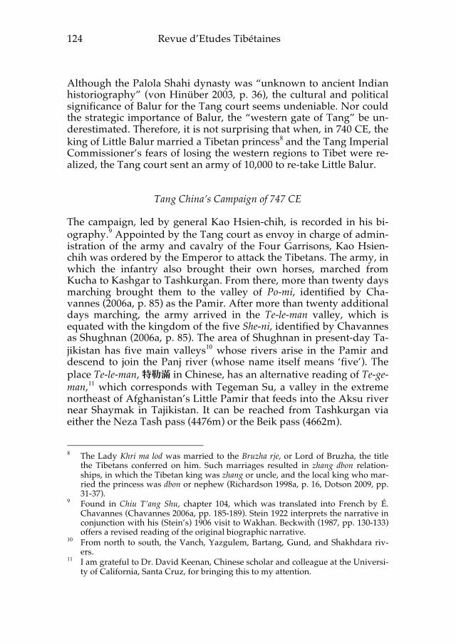
Shaur stream.13 In the Chap Dara area, high on a spur ridge with excellent views
of the entire valley, is a ruined structure constructed of flat stones placed on top of each other (see Fig. 3).
Fig. 3 – ruined structure in Chap Dara It has been dismantled and dug by “illegal excavators”, according to Wakhi herders. This structure matches the locational and structural parameters for a hill-station (Tib. ri-zug) used for signaling with fire or smoke to raise the alarm if enemies approached.14
Numerous rock carvings and inscriptions near this ruined stone structure demonstrate substantial human occupation of the site over many years. The oldest rock carvings15 depict ibex, argali sheep, yaks,
13 When Kimberley O’Neil and I explored this area in 2005 and 2007, we were una-
ware of any other non-local persons having visited the area. We subsequently learned that the Japanese medical doctor Go Hirai explored this route and identi-fied it as the “Northern Gorge” route in 2001 (Hirai 2002).
14 Stein (1912, pp. 152-153) described these at Miran. Takeuchi studied them in de-tail and suggested they may have also existed along the southern route of the Silk Road including “Little and Great Balur … and the Pamirs” (2004, p. 55). Mu Shunying mentions Han and Tang dynasty beacon towers along the northern and southern routes of the Silk Road (1984, p. 65). Dotson links the Tibetan hill-stations with “red fire raising stations” that are mentioned in the Old Tibetan Annals (2009, pp. 56-57).
15 For a thorough discussion of Central Asian rock art see Tashbayeva 2001, espe-cially the section on Petroglyphs of Tadjikistan (Tashbayeva 2001, pp. 122-148),

Tibetans in Wakhan
127
and humans holding spears or bows. Such rock art hunting scenes are widely found throughout Central Asia and were likely related to ritual practices that ensured hunting success (Dodykhudoeva 2004, pp. 151-152; Hauptmann 2007, pp. 24-25, Bellezza 2008, p. 173). The spiritual dimension of the rock art at this site is demonstrated in one panel which shows a hunter holding a spear, several ibex, a yak, and a large ibex with exaggeratedly long curving horns (see Fig. 4). The excessively large size of this ibex with a reverse (counter-clockwise) swastika above and a crescent moon beneath suggests a ritual func-tion for the art.16 (Also published as Fig. 16 and Plate IVb in Mock 2013c).
Fig. 4 - large ibex with reverse swastika and crescent moon There are nine chorten (Tib. mchod-rten) or chorten-like structures17 (see
which includes a site from the north bank of the Panj river in Tajkistan Wakhan. For additional material from Wakhan, see Mock 2013c.
16 These symbols have been associated with Bon traditions. See Hoffman 1969 for a discussion of Bon religion and Bru-sha, the Tibetan name for Burusho people speaking Burushaski language (presently in Hunza and Yasin valleys of Paki-stan). See Bellezza 2010, 2016a, 2016b for examples from Upper Tibet.
17 Ceremonial structures depicted on rocks likely served as a locus of ritual practice for not only Buddhist tradition. They are stepped and usually have a mast or fi-

Revue d’Etudes Tibétaines 128
Fig. 5) depicted on rocks at this site.18
Fig. 5 – chorten-like depictions and swastika Six have Old Tibetan epigraphs associated with them.19 Three of the epigraphs are legible and are discussed below. Two of them name the donors of the chorten and one of those epigraphs has a date in the twelve-year cycle. The third epigraph gives what appears to be a name, but whether it is a donor and whether the structure depicted is a Buddhist chorten or other ceremonial structure is undetermined.
In addition to the epigraphs associated with the chorten, there are eight additional Old Tibetan inscriptions. Most of them are quite weathered and difficult to read. One readable epigraph, discussed below, is not associated with a chorten and gives a date in the twelve-year cycle. Another is the unique Tibetan toponym for Wakhan, dis-cussed in Mock 2013a. The other seven inscriptions are difficult to read, due to weathering and/or lichen growth on the rock.20 These inscriptions are on horizontal rocks, where snow and rain accumulate and weathering tends to be more pronounced.
The variety of rock art, including hunting scenes, animals, shrine structures, and Tibetan inscriptions indicate significant human use of
nial (see Bellezza 2008, pp. 182-186 for detailed discussion of categories of shrines in rock art).
18 Space constraints preclude discussion of all of the ceremonial structures depicted. A full-length treatment of the site, following additional field work in 2016, is planned.
19 For discussion of the paleography of inscriptions, see Takeuchi 2013a and van Schaik 2014.
20 Two inscriptions appear to begin with a year, byi ba lo’i, and end with bris, sug-gesting they follow a formula of date – name – inscribed, as discussed in Takeuchi 2013b, pp. 29-30.
Tibetans in Wakhan
129
the site over time. The site today does not hold any cultural signifi-cance and is not associated with any legends for the Wakhi inhabit-ants of Wakhi, who told me that they were “made by fereshta” (“an-gel” or “fairy” in Persian).21
The Old Tibetan inscriptions and associated chorten structures are relevant to the history of the Tibetan empire in Wakhan. If this site was on the “northern gorge” route taken by the three-thousand horsemen of the Chinese army in 747 CE, why was it not mentioned in Kao Hsien-chih’s biography or elsewhere in Tang records? Alt-hough absence of evidence does not equal evidence of absence, the lack of any mention of Chinese forces encountering Tibetans or of a Tibetan-occupied site in the detailed narrative of Kao Hsien-chih’s biography would seem a significant omission had Tibetans been at the Chap Dara site. The simplest explanation is that Tibetans did not occupy the site at that time. Perhaps only after the successful Chinese expedition of 747 CE did the Tibetans, who reasserted their influence in Wakhan in 756 CE (Beckwith 1987, pp. 144-145; Denwood 2009, p. 156), station forces at the site to guard against enemies approaching via the “northern gorge” route.
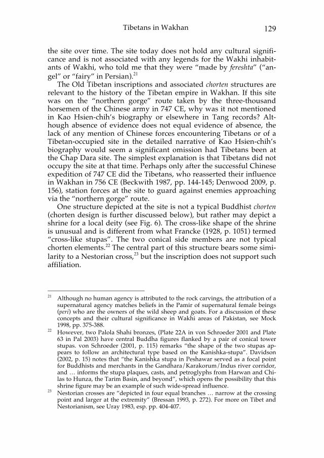
One structure depicted at the site is not a typical Buddhist chorten (chorten design is further discussed below), but rather may depict a shrine for a local deity (see Fig. 6). The cross-like shape of the shrine is unusual and is different from what Francke (1928, p. 1051) termed “cross-like stupas”. The two conical side members are not typical chorten elements.22 The central part of this structure bears some simi-larity to a Nestorian cross,23 but the inscription does not support such affiliation.
21 Although no human agency is attributed to the rock carvings, the attribution of a
supernatural agency matches beliefs in the Pamir of supernatural female beings (peri) who are the owners of the wild sheep and goats. For a discussion of these concepts and their cultural significance in Wakhi areas of Pakistan, see Mock 1998, pp. 375-388.
22 However, two Palola Shahi bronzes, (Plate 22A in von Schroeder 2001 and Plate 63 in Pal 2003) have central Buddha figures flanked by a pair of conical tower stupas. von Schroeder (2001, p. 115) remarks “the shape of the two stupas ap-pears to follow an architectural type based on the Kanishka-stupa”. Davidson (2002, p. 15) notes that “the Kanishka stupa in Peshawar served as a focal point for Buddhists and merchants in the Gandhara/Karakorum/Indus river corridor, and … informs the stupa plaques, casts, and petroglyphs from Harwan and Chi-las to Hunza, the Tarim Basin, and beyond”, which opens the possibility that this shrine figure may be an example of such wide-spread influence.
23 Nestorian crosses are “depicted in four equal branches … narrow at the crossing point and larger at the extremity” (Bressan 1993, p. 272). For more on Tibet and Nestorianism, see Uray 1983, esp. pp. 404-407.
Revue d’Etudes Tibétaines 130
Fig. 6 - ‘jang lha inscription and shrine depiction On the top cross piece the inscription reads ’jang lha, which may refer to a local deity of the place (yul lha).24 On the base, the inscription reads ‘phan gyI yon.25 The phrase gyI yon is a typical offering phrase in which the possessive/genitive case marker gyI and the noun yon (“gift”) follow a name (Karmay 1998, pp. 327, 330). The name in this inscription, ‘phan, is attested in Richardson’s list of titles (Tib. mkhan) (Richardson 1998a, p. 20) and Denwood notes it was “frequent in Central Asia”, citing an example from Dunhuang (Denwood 1980b, p. 162). Perhaps a local person who was a native of Wakhan or Bru-sha serving with the Tibetans offered this shrine composition and
24 Yul lha, “deities of the local territory” are mountain deities. The term yul lha is
attested in the Dunhuang manuscript PT 1047 (Karmay 1998, pp. 432, 442). The ancient tradition of mountain deities is authochthonous and specific to a particu-lar place and community (Karmay 2005, p. 33), consistent with the hypothesis that ’Jang lha may be a deity of this class.
25 The reversed gi-gu (transliterated with I) is an archaic orthographic variant that was common in Dunhuang manuscripts but gradually fell out of use by the 12th century (Denwood 1980b, p. 161; van Schaik 2014).

Tibetans in Wakhan
131
had a literate individual incise the inscription.26
Fig. 7 – Nam bshud’s inscription On the lower left corner of the same rock panel is an inscription read-ing: spre'u'i lo'i ston nam bshud rtsa rtse sa bris Tsuguhito Takeuchi (pers. com.) kindly pointed out that rtse sa may be read as tses, giving: spre'u'i lo'i ston nam bshud rtsa tses bris which he notes follows an inscription formula frequently found in Ladakh.27 Accordingly, an English rendition could be, “In autumn of the monkey year, Nam bshud rtsa tses inscribed (this)”. Above the inscription on a separate layer of rock is a weathered syllable that may be ‘brug or sbrul. Nam bshud does not seem to be a known clan name or a title and may be a non-Tibetan, local name. The inscription provides a date in the twelve-year cycle, naming the autumn season (ston) but not the month (first, middle or last) of the season (Francke 1914, p. 48). Another chorten offering on a separate rock face provides a much more precise date (see Fig. 8).
26 Or perhaps the inscriber was not Tibetan but was literate in Tibetan. Scribes from
Khotan wrote in Tibetan at Dunhuang (Dalton 2007) and Central Asian people under the Tibetan Empire acquired Literary Tibetan (Takeuchi 2013a, pp. 6-7).
27 Published examples from the ruined fort (mkhar ’gog) on the left bank of the In-dus near Saspol on the road to Alchi are found in Denwood 1980b, Francke and Jina 2003, and Takeuchi 2013b. Orofino 1990 has examples from beyond Alchi.

Revue d’Etudes Tibétaines 132
Fig. 8 – Khyung-po Rgyal-tsug’s chorten offering The inscription reads:
bru gi lo'i ston sla bring po tshes nyi shu la zhengs (zhengs is inscribed on the other side of the chorten) khyung po rgyal tsug gyi yon
This inscription identifies the dragon year (bru gi lo), the middle month of autumn (ston sla bring-po), the twentieth day, and the meri-tous donor Khyung-po Rgyal-tsug.
The Old Tibetan year was divided into four seasons, each of which had three months (Dotson 2009, p. 12). Although it is not clear how many days were in each month,28 the middle autumn month corre-sponds roughly to September. The Tang calendar and the Old Tibet-an calendar did not coincide, but comparative dating using the Chi-nese calendar (Hsueh 1940; Tibetan Medical & Astrological Institute 1998) show that the twentieth day of the middle autumn month of 28 I am grateful to Christopher Beckwith for pointing out the uncertainties of as-
signing western dates to Old Tibetan reckonings. For discussion of the question of Old Tibetan chronology, see Beckwith 1989, pp. xvi-xviii, and Dotson 2009, pp. 12-13. The old “farmer’s new year” (Tib. so-nam lo-gsar), still observed in outlying rural regions of Tibet, offers another point of reckoning for the start of the year, and I am grateful to John Bellezza for discussing it with me. See Gergan 1978 for discussion of Losar in Zhang-Zhung and Pirie 2008 for discussion of Losar in Ladakh, both of which observe the so-nam lo-gsar reckoning. In the Pamir today, the winter solstice is literally observed as the annual turning point of the year, as part of the still-followed traditional “farmer’s calendar” (Iloliev 2008, pp. 92-93, Mock 1998, p. 291).
Tibetans in Wakhan
133
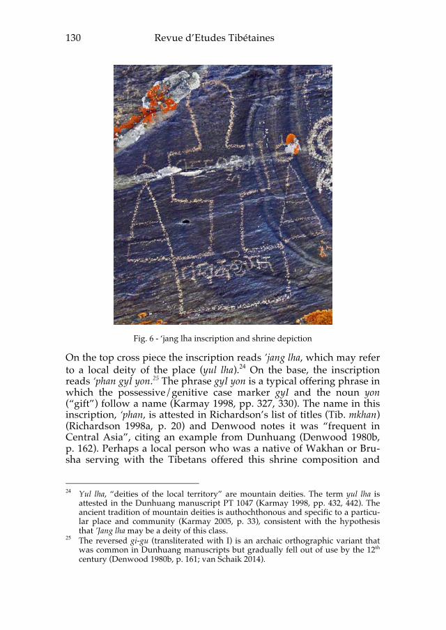
the dragon years between 764 CE and 848 CE29 fell between 12 Sep-tember and 7 October. For an elevation of over 4000m, such dates would be near the end of the season when the site might be occupied, although certainly plausible for occupation.30
The name given in the inscription, Khyung-po, is an Old Tibetan clan name. Typically, clan names (Tib. rus) precede personal names (Tib. mying) in such inscriptions (Francke 1928, p. 1050; Richardson 1998a, p. 18; Takeuchi pers. com.). Richardson’s list (1998a, p. 18) of mying does not include Rgyal-tsug, but does have Rgyal-kong, Rgyal-sum-gzigs and Rgyal-slebs.
This Old Tibetan name and Old Tibetan date accompany an archa-ic chorten. It has a base with three diminishing stages, a tall middle section and upper projecting stages topped by a small dome, a mast and ‘horned sun’ (or crescent moon and sun) finial. Denwood noted that this design, typical of the western Himalaya and Karakoram, was termed “cross-shaped” by Francke who saw “a fancied resem-blance to a Christian cross” (Denwood 2007, p. 45), and that Jettmar considered the design to be an innovation made during the time of imperial Tibetan rule in the region. Denwood published a similar de-sign from near Alchi in Ladakh (Denwood 2007, p. 52, fig. 5), Tucci photographed similar designs near Alchi and at Khalatse (Orofino 1990, figs. 17, 18, 30, 39, 40) and Jettmar and Sagaster (1993) pub-lished a similar design from Gakuch in present-day Pakistan. Den-wood described the sun and crescent moon finial as a distinctive Bon-po element (Denwood 1980a, p. 176). This Bon-po aspect, along with the previously mentioned hunting ritual rock art panel containing symbols associated with Bon (Fig. 4 above), suggests a continuation of beliefs and practices from pre-Tibetan to Tibetan times.31 29 Tibetan control of Wakhan appears to have resumed in 756 CE and lasted until
the mid or late 9th century CE, which serves as a terminus ante quem for the Tibet-an inscriptions. Tibetan control of Dunhuang lasted from 781-848 CE (Dalton 2007, p. 18; but see Horlemann 2000 for an earlier date of in the 760s, which paral-lels dates for Wakhan). Although an Arab army defeated Wakhan in 814-15 (Beckwith 1987, pp. 160-162), Tibetan control soon returned. However, by the end of the ninth century, the high water mark of Buddhism in the Hindukush and Pamir had receded, the Tibetan empire no longer reached to Wakhan, and the re-gion was increasingly influenced by Islam (Beckwith 1987, p. 172; Denwood 2008, p. 157; Hauptmann 2007, p. 32).
30 Early autumn, as we understand the modern autumn season, at 4035m in the Pamir, has relatively light snowfall and rivers are low and easier to cross. Winter brings heavy snow, which lingers through spring, when there is substantial ava-lanche danger and movement is difficult. Summer is the main pasturing season, but rivers are at their peak and difficult to cross.
31 Fussman (1986, p. 47, n. 40) mentions a similar sun-moon finial on a rock carving of a stupa from Chilas I in the Indus valley, and notes that although such finials are typically identified as Tibetan, the example from Chilas is Indian and “is cer-

Revue d’Etudes Tibétaines 134
Another chorten on a separate rock at the site is not so finely in-scribed (see Fig. 9). It has a three-stage base, but the central column is not as tall and it has only a single projecting upper stage. The mast is shorter, but does appear to be topped by the horn-like crescent moon and orb symbol. The rock on which this chorten is inscribed does not have a smooth, varnished surface, but rather a rougher texture, with much lichen present.32
Fig. 9 – btsan la gzigs’ chorten offering The inscription reads: rMe-‘or btsan la gzigs gyI [x], conforming to the formula where final yon (“gift”) would be expected but in this in-scription is not legible. The name btsan was known as a ministerial
tainly to be dated in the 1st century A.D.” Bruneau discusses the crescent moon and sun finial, and notes that Gandharan viharas from Butkara I are depicted with a crescent moon or a disc (Bruneau 2007, p. 66). Orofino (1990, pp. 173-174, n. 2) touches briefly on the question of the relationships of Buddhism as practiced in Swat and Gilgit, the Bon-po traditions of Zhang Zhung, and Tibetan Bud-dhism. Buddhism was officially adopted by the Tibetan royalty in 779 CE (Dot-son 2009, p. 20), which is around the time that the Wakhan art and inscriptions were made. The Tibetan empire’s military projection into these regions brought close contact and interaction which is evidenced by the sending of a copy of the 782 edict of Khri-song-lde-tsan to the country of Bru-sha (Richardson 1998, pp. 91, 93). The “delicate and fascinating” question of the transmission of Buddhism be-tween Gilgit (Bruzha), Western Tibet (Zhang Zhung) and central Tibet is dis-cussed in Scherrer-Schaub 2002.
32 The chorten and inscription are discussed and published in Mock 2013b.

Tibetans in Wakhan
135
title for a person descended from the royal family of Ladakh (Francke 1914, p. 51) and bTsan-gzigs appears on Francke’s list of names (Francke 1914, p. 40). Richardson includes Btsan-zigs in his list of mkhan, a term which he says “seems to signify some sort of title” in Old Tibetan (Richardson 1998a, pp. 17-20). This seems to be an Old Tibetan name or title, perhaps that of a person who had come from the Ladakh area.33
The clan name rMe-‘or is also relevant to historical questions. Alt-hough not appearing in any known lists, this same clan name does appear in the Darkot pass inscription accompanying a chorten of simi-lar design (see Mock 2013b for the photo and discussion). The Darkot chorten has the same “cross-shaped” design, with a two-stage base, a tall central pillar, and two projecting stages below a more oval dome. It has a double mast structure, with a horn-like finial and a more complex central orb on a cross-shape staff. But the general design of the chorten, the inscription formula, the identical clan name, the phys-ical proximity of the Darkot pass to Wakhan and the Tang Annals documentation of the Darkot pass as a route to Wakhan all link the Darkot chorten to this Wakhan chorten and site. Following the previ-ously stated hypothesis that the extensive Wakhan site could not have gone unmentioned in the Tang account of the events of 747 CE, the dating of the Darkot inscription to the same period, when the otherwise unknown rMe-‘or clan must have held some prominence, seems reasonable.34
Conclusion Further study of the Wakhan site and translation of all the Tibetan inscriptions there will help us to better understand the site and its relation to the religious and historical context of the 8th-9th centuries CE. But certainly we now have evidence of the western Himalayan chorten style further north than previously known. The material demonstrates a deeper Tibetan involvement in Wakhan in the 8th and 9th centuries CE and provides significant information about the events of 747 CE, when a Chinese army defeated Tibetan forces at Lien-yün. The material, in conjunction with textual evidence and analysis of the topographic realities on the ground enables identifica-
33 Ladakh was clearly under Tibetan control by 719 CE, when Tibet conducted a
census there (Denwood 2009, p. 43). 34 Takeuchi (2011, p. 55) notes that the Darkot inscription and others in present-day
Gilgit-Baltistan date from the late 8th-early 9th c. CE, which was the only time when Tibetan imperial power reached as far north-west as Gilgit (and Wakhan).
Revue d’Etudes Tibétaines 136
tion of the “northern gorge” route taken by Chinese forces. Explora-tion of the “northern gorge” route has identified a significant Tibetan site, with what appears to be important pre-Tibetan mytho-religious symbolism forming an earlier locus of activity at the site. Textual ev-idence from the Tang Annals and the Old Tibetan Annals offers a ba-sis to assume the site was occupied by Tibetans only after 747 CE and most probably after 756 CE. The site and other monuments discov-ered in Afghanistan support the existence of a network of watch tow-ers and signaling towers in Wakhan. An inscription at the “northern gorge” site links it to the well-known Darkot inscription and provide a context for more closely dating that inscription. Stylistic elements of the chorten carvings in Wakhan, along with onomastic elements of the inscriptions, offer evidence of links with Gandharan-influenced traditions from Balur, with the Ladakh region, and with as yet uni-dentified local or regional traditions, which may include the indige-nous Brusha or other Central Asian groups allied with the Tibetan empire.
Acknowledgments Thanks to Dr. Mark Tatz, formerly of the California Institute of Inte-gral Studies; John Vincent Bellezza, Senior Research Fellow at the Ti-bet Center, University of Virginia; Lobsang Tsering, formerly of Gyumed Tantric University; Professor Christopher Beckwith of Indi-ana University and Professor Tsuguhito Takeuchi of Kobe City Uni-versity of Foreign Studies for their readings and translations of in-scriptions. The map of Wakhan is by Mariele Paley, used with kind permission. The photograph of the Palola Shahi bronze of Nandi-vikramadityanandi is by Hugh DuBois, from the Pritzker Collection, used with kind permission of the owners. The photograph of the ru-ined structure in Chap Dara is by Don Bedunah, used with kind permission. All other photographs are by John Mock. Thanks to the W. L. Gore Inc. Shipton-Tilman Grant program, the Deutsche Gesell-schaft für Technische Zusammenarbeit (GTZ), the Aga Khan Founda-tion-Afghanistan, the Wildlife Conservation Society, and The Chris-tensen Fund for enabling travel to Wakhan.
References Beckwith, Christopher, The Tibetan Empire in Central Asia: A History of
the Struggle for Great Power Among Tibetan, Turks, Arabs and Chi-nese During the Early Middle Ages, Princeton, Princeton Universi-
Tibetans in Wakhan
137
ty Press, 1987. Bellezza, John V., Zhang Zhung: foundations of civilization in Tibet: a
historical and ethnoarchaeological study of the monuments, rock art, texts, and oral tradition of the ancient Tibetan upland, Wien, Östereichischen Akademie der Wissenschaften, 2008.
—— Flight of the Khyung, September 2010, on-line resource accessed May 2016.
http://www.tibetarchaeology.com/september-2010/ —— Flight of the Khyung, May 2016a, on-line resource accessed July
2016. http://www.tibetarchaeology.com/may-2016/ —— Flight of the Khyung, June 2016b, on-line resource accessed July
2016. http://www.tibetarchaeology.com/june-2016/ Bressan, L.C., “Rock-Carved Crosses from the 7th Century in North-
ern Areas of Pakistan”, Journal of Central Asia, 16:1-2, 1993, pp. 270-282.
Bruneau, Laurianne, “L’architecture bouddhique dans la vallée du Haut Indus; un essai de typologie des représentations rupestres de stûpa,” Arts Asiatiques, no. 62, 2007, pp. 63-75.
Chavannes, Édouard, Documents sur les Tou-kiue (Turcs) occidentaux, St. Petersburg, 1903, internet edition http://bibliotheque.uqac. ca Quebec, 2006a.
—— Notes Additionnelles sur les Tou-kiue (Turcs) occidentaux, Paris, 1903, internet edition http://bibliotheque.uqac.ca/ Quebec, 2006b.
Dalton, Jacob, Tom Davis and Sam van Schaik, “Beyond Anonymity: Paleographic Analyses of the Dunhuang Manuscripts”, Journal of the International Association of Tibetan Studies, no. 3 (December 2007), pp.1-23. http://www.thlib.org?tid=T3106 accessed May 23, 2016.
Davidson, Ronald M., “Hidden Realms and Pure Abodes: Central Asian Buddhism as Frontier Religion in the Literature of India, Nepal, and Tibet”, The Pacific World, vol. 4, 2002, pp.153-181.
Denwood, Philip, “Stupas of the Tibetan Bonpos”, in A.L. Dallapicco-la, ed., The stūpa: Its religious, historical and architectural signifi-cance, Wiesbaden, Steiner, 1980a, pp. 175-182.
—— “Temple and Rock Inscriptions of Alchi”, in D.L. Snellgrove & T. Skorupski, eds., The Cultural Heritage of Ladakh, vol. 2, Zangskar and the cave temples of Ladakh, Aris & Phillips, Warminster (England), 1980b, pp. 117-164.
—— “The Tibetans in the Western Himalayas and Karakoram, Sev-enth-Eleventh Centuries: Rock Art and Inscriptions”, The Jour-nal of Inner Asian art and archaeology, 2:2, 2007, pp. 49-57.
Revue d’Etudes Tibétaines 138
—— “Tibetans in the West, Part I”, The Journal of Inner Asian art and archaeology, 3:3, 2008, pp. 7-21.
—— “Tibetans in the West, Part II”, The Journal of Inner Asian art and archaeology, 4:4, 2009, pp. 149-160.
Dodykhudoeva, Leila, “Ethno-cultural Heritage of the Peoples of West Pamir”, Collegium Antropologium, 28 (Supplement 1), 2004, pp. 147-59.
Dotson, Brandon, The Old Tibetan Annals: An Annotated Translation of Tibet’s First History, Vienna, Verlag der osterreichischen Akad-emie der Wissenschaften, 2009.
Francke, Auguste H., “Notes on Sir Aurel Stein’s Collection of Tibet-an Documents from Chinese Turkestan”, Journal of the Royal Asiatic Society, 1914, pp. 37-59.
—— “A Tibetan Inscription on the Darkot Pass”, Appendix L in M.A. Stein Innermost Asia, Oxford, Clarendon, 1928, pp. 1050-1051.
Francke, A.H. and P.S. Jina, First Collection of Tibetan Historical Inscrip-tions on Rock and Stone from Ladakh Himalaya, Delhi, Sri Satguru Publications, 2003.
Fussman, Gérard, “Symbolisms of the Buddhist Stupa”, The Journal of the International Association of Buddhist Studies, 9:2, 1986, pp. 37-53.
Gergan, S.S., “The Lo-sar of Ladakh, Spiti, Lahul, Khunnu and West-ern Tibet”, The Tibet Journal, 3:3, Autumn 1978, pp. 41-43.
Hauptmann, Harald, “Pre-Islamic Heritage in the Northern Areas of Pakistan”, in S. Bianca, ed., Karakoram: Hidden Treasures in the Northern Areas of Pakistan, Turin, Aga Khan Trust for Culture, 2007, pp. 21-40.
von Hinüber, Oskar, “The Magnificent Bronze of Nandi-vikramadityanandi: A Delight for the Beholder, A Worry for the Epigraphist”, Orientations 34:4, 2003, pp. 35-39.
—— Die Palola Sahis: Ihre Steininschriften, Inschriften auf Bronzen, Handschriftenkolophone und Schutzzauber, Mainz, Philipp von Zabern, 2004.
Hirai, Go, “A Journey to Afghan Pamir”, Japanese Alpine News 2, April 2002, republished in Japanese Alpine News 16, 2015, pp. 77-82.
Hoffman, Helmut, “An Account of the Bon Religion in Gilgit”, Cen-tral Asiatic Journal, 13:2, 1969, pp. 137-145.
Horlemann, Bianca, “A Re-evaluation of the Tibetan Conquest of Eighth Century Shazhou/Dunhuang”, Proceedings of the Interna-tional Association of Tibetan Studies: Tibet, past and present: PIATS 2000, pp. 49-66.
Hsueh, Chung-san and Yi Ouyang, A Sino-Western Calendar for Two Thousand Years 1-2000 A.D., Changsha, China, The Commercial
Tibetans in Wakhan
139
Press, Ltd., 1940. Iloliev, Abdulmamad, “Popular Culture and Religious Metaphor:
Saints and Shrines in Wakhan Region of Tajikistan”, Central Asian Survey, 27:1, 2008, pp. 59-73.
Imaeda, Yoshiro, “Towards a Comprehensive and Unambiguous Transliteration Scheme of Tibetan,” in Imaeda et al., eds., New Studies of the Old Tibetan Documents: Philology, History and Reli-gion, Old Tibetan Documents Online Monograph Series, vol. III, Research Institute for Languages and Cultures of Asia and Af-rica, Tokyo, Tokyo University of Foreign Studies, 2011, pp. 39-43.
Iwao, Kazushi et al., eds., Old Tibetan Inscriptions, Old Tibetan Docu-ments Online Monograph Series, vol. II, Research Institute for Languages and Cultures of Asia and Africa, Tokyo, Tokyo Uni-versity of Foreign Studies, 2009.
Jettmar, Karl, ed., Antiquities of Northern Pakistan: Rock inscriptions in the Indus Valley, vol. 1, Mainz, Philipp von Zabern, 1989.
Jettmar, Karl and Klaus Sagaster, “Ein Tibetisches Heiligtum in Pu-nyal”, in K. Jettmar, ed., Antiquities of Northern Pakistan: Reports and Studies, vol. 2, Mainz, Philipp von Zabern, 1993, pp. 123-140.
Karmay, Samten G., The Arrow and the Spindle: Studies in History, Myths, Rituals and Beliefs in Tibet, vol. 1, Kathmandu, Mandala Book Point, 1998.
—— The Arrow and the Spindle: Studies in History, Myths, Rituals and Beliefs in Tibet, vol. 2, Kathmandu, Mandala Book Point, 2005.
Mock, John, The Discursive Construction of Reality in the Wakhi Commu-nity of Northern Pakistan, Ph.D. Dissertation, Berkeley, Universi-ty of California, 1998.
—— "A Tibetan Toponym from Afghanistan", Revue d'Etudes Tibétaines no. 27, Oct. 2013a, pp. 5-9.
—— “Darkot Revisited: New Information on a Tibetan Inscription and mchod-rten”, Revue d'Etudes Tibétaines no. 27, Oct. 2013b, p. 11-19.
—— “New Discoveries of Rock Art from Afghanistan’s Wakhan Corridor and Pamir: A Preliminary Study”, The Silk Road 11, Sa-ratoga (CA), Silkroad Foundation, 2013c, pp. 36-53; Plates III-IV.
Orofino, Giacomella, “A Note on Some Tibetan Petroglyphs of the Ladakh Area”, East and West, 40:1-4, pp. 173-200.
Pal, Pratipaditya, Himalayas: An Aesthetic Adventure, Chicago, Art in-stitute of Chicago, 2003.
Pirie, Fernanda, “Dancing in the Face of Death: Losar Celebrations in Photoksar”, in van Beek, Martijn and Fernanda Pirie, eds.,

Revue d’Etudes Tibétaines 140
Brill's Tibetan Studies Library: Modern Ladakh: Anthropological Perspectives on Continuity and Change, Leiden, NL: Brill, 2008, ProQuest ebrary, Web, 9 July 2016.
Richardson, Hugh, “Names and Titles in Early Tibetan Records”, in H. Richardson, High Peaks, Pure Earth: Collected Writings on Ti-betan History and Culture, M. Aris, ed., London, Serindia Publi-cations, 1998, pp. 12-24.
—— “The First Tibetan Chos-’byung”, in H. Richardson, High Peaks, Pure Earth: Collected Writings on Tibetan History and Culture, M. Aris, ed., London, Serindia Publications, 1998, pp. 89-99.
van Schaik, Sam, “Towards a Tibetan Palaeography: developing a typology of writing styles in early Tibet”, in Quenzer, Jörg B., Dmitry Bondarev and Jan-Ulrich Sobisch, eds., Manuscript cul-tures: mapping the field. De Gruyter, Boston, 2014, ProQuest ebrary, Web. 6 May 2016.
von Schroeder, Ulrich, Buddhist Sculptures in Tibet, vol. 1, India & Ne-pal, Visual Dharma, Hong Kong 2001.
Scherrer-Schaub, Cristina, “Enacting Words: A Diplomatic Analysis of the Imperial Decrees (Bkas Bcad) and their Application in the Sgra Sbyor Bam Po Gñis Pa Tradition”, Journal of the International Association of Buddhist Studies, 25:1-2, 2002, pp. 263-340.
Shunying, Mu, “Development and achievement of archaeology in Xinjiang since the Founding of New China”, Journal of Central Asia, 3:1, 1984, pp. 55-72.
Stein, Mark Aurel, Ruins of Desert Cathay, London, MacMillan & Co., 1912.
—— A third journey of exploration in Central Asia: 1913-1916, London: Royal Geographical Society, 1916.
—— “A Chinese Expedition across the Pamirs and Hindukush, A. D. 747”, The Geographical Journal, 59:2, 1922, pp. 112-31.
Takeuchi, Tsuguhito, “The Tibetan Military System and its Activities from Khotan to Lop-Nor”, in S. Whitfield, ed., The Silk Road: Trade, Travel, War and Faith, Chicago, Serindia Publications, 2004, pp. 50-56.
—— “Historical Development of the Tibetan Languages”, Journal of the Research Institute, no. 49, Kobe, Kobe City University of For-eign Studies, 2013a, pp. 3-17.
—— “Old Tibetan Rock Inscriptions Near Alchi”, Journal of the Re-search Institute, no. 49, Kobe, Kobe City University of Foreign Studies, 2013b, pp. 29-69.
Tashbayeva, K., ed., Petroglyphs of Central Asia, Samarkand, Interna-tional Institute for Central Asian Studies, 2001.
Tibetan Medical & Astrological Institute of H.H. the Dalai Lama, Ti-betan astronomy and astrology, Dharamsala: Documentation and
Tibetans in Wakhan
141
Publication Department, Men-tsee-khang, 1998. Uray, Geza, “Tibet’s Connections with Nestorianism and Manicheism
in the 8th-10th Centuries”, in E. Steinkellner and H. Tauscher, eds., Contributions on Tibetan Language, History and Culture. Wien: Arbeitskreis für Tibetische und Buddhist Studien, 1983.
Zeisler, Bettina, “East of the Moon and West of the Sun? Approaches to a Land with Many Names, North of Ancient India and South of Khotan”, The Tibet Journal, 34/35: 3-4/1-2, 2009, pp. 371-463.
v