thumbnail francis, kelvin matthews, delia sandford and radjan lourde selvanadin at wiley blackwell...
TRANSCRIPT

Field Guide to the Carboniferous Sediments of the Shannon Basin Western Ireland
A Field Guide to the Carboniferous Sediments of the Shannon Basin Western Ireland
Edited by
JamES L BESt amp PauL B WIGnaLL
this edition first published 2016copy 2016 by the International association of Sedimentologists
Registered OfficeJohn Wiley amp Sons Ltd the atrium Southern Gate Chichester West Sussex PO19 8SQ uK
Editorial Offices9600 Garsington Road Oxford OX4 2DQ uKthe atrium Southern Gate Chichester West Sussex PO19 8SQ uK111 River Street Hoboken nJ 07030‐5774 uSa
For details of our global editorial offices for customer services and for information about how to apply for permission to reuse the copyright material in this book please see our website at wwwwileycomwiley‐blackwell
the right of the author to be identified as the author of this work has been asserted in accordance with the uK Copyright Designs and Patents act 1988
all rights reserved no part of this publication may be reproduced stored in a retrieval system or transmitted in any form or by any means electronic mechanical photocopying recording or otherwise except as permitted by the uK Copyright Designs and Patents act 1988 without the prior permission of the publisher
Designations used by companies to distinguish their products are often claimed as trademarks all brand names and product names used in this book are trade names service marks trademarks or registered trademarks of their respective owners the publisher is not associated with any product or vendor mentioned in this book
Limit of LiabilityDisclaimer of Warranty While the publisher and author(s) have used their best efforts in preparing this book they make no representations or warranties with respect to the accuracy or completeness of the contents of this book and specifically disclaim any implied warranties of merchantability or fitness for a particular purpose It is sold on the understanding that the publisher is not engaged in rendering professional services and neither the publisher nor the author shall be liable for damages arising herefrom If professional advice or other expert assistance is required the services of a competent professional should be sought
Library of Congress Cataloging‐in‐Publication data applied for
ISBn 9781119257127
a catalogue record for this book is available from the British Library
Wiley also publishes its books in a variety of electronic formats Some content that appears in print may not be available in electronic books
Cover image James L Best and Paul B Wignall
Set in 925115pt times new Roman by SPi Global Pondicherry India
1 2016
v
Contents
Contributors vii
Acknowledgements ix
About the Companion Website xi
1 Introduction to the Field Guide 1Jim Best amp Paul B Wignall
2 The Shannon Basin Structural Setting and Evolution 16John Graham
3 Basin Models 35Paul B Wignall amp Jim Best
4 Lower Carboniferous of the Shannon Basin Region 48Ian D Somerville
5 Viseacutean Coral Biostromes and Karsts of the Burren 79Ian D Somerville
6 The Clare Shales 97Paul B Wignall Ian D Somerville amp Karen Braithwaite
7 Architecture of a Distributive Submarine Fan The Ross Sandstone Formation 112David R Pyles amp Lorna J Strachan
8 Evolving Depocentre and Slope The Gull Island Formation 174Lorna J Strachan amp David R Pyles
vi Contents
9 The Tullig and Kilkee Cyclothems in Southern County Clare 240Jim Best Paul B Wignall Eleanor J Stirling Eric Obrock amp Alex Bryk
10 The Tullig and Kilkee Cyclothems of Northern County Clare 329Paul B Wignall Jim Best Jeff Peakall amp Jessica Ross
11 The Younger Namurian Cyclothems around Spanish Point 350Paul B Wignall amp Jim Best
Appendix List of GigaPan Images 361
References 362
Index 371
vii
Contributors
Editors
Jim Best Jack and Richard Threet Chair in Sedimentary Geology Departments of Geology Geography amp GIS Mechanical Science and Engineering and Ven Te Chow Hydrosystems Laboratory University of Illinois at Urbana‐Champaign 605 East Springfield Avenue Champaign IL 61820 USA
Paul B Wignall School of Earth and Environment University of Leeds Leeds West Yorkshire LS2 9JT UK
Contributors
Karen Braithwaite School of Earth and Environment University of Leeds Leeds West Yorkshire LS2 9JT UK now at School of Veterinary Medicine and Science University of Nottingham College Road Sutton Bonington Loughborough Leicestershire LE12 5RD UK
Alex Bryk Department of Geology University of Illinois at Urbana‐Champaign 605 East Springfield Avenue Champaign IL 61820 USA now at Department of Earth and Planetary Science University of California Berkeley 307 McCone Hall Berkeley CA 94720 USA
John Graham Department of Geology Museum Building Trinity College Dublin Dublin 2 Ireland
Eric Obrock Department of Geology University of Illinois at Urbana‐Champaign 605 East Springfield Avenue Champaign IL 61820 USA now at ExxonMobil 22777 Springwoods Village Parkway Spring TX 77389 USA
Jeff Peakall School of Earth and Environment University of Leeds Leeds West Yorkshire LS2 9JT UK
David R Pyles EOG Resources 600 17th Street Suite 1000N Denver CO 80202 USA Formerly at Chevron Centre of Research Excellence Department of Geology and Geological Engineering Colorado School of Mines Golden CO 80401 USA
viii Contributors
Jessica Ross School of Earth and Environment University of Leeds Leeds West Yorkshire LS2 9JT UK now at Maersk Oil North Sea UK Maersk House Crawpeel Road Aberdeen AB12 2LG UK
Lorna J Strachan Earth Science Programme School of Environment University of Auckland Auckland 1142 New Zealand
Eleanor J Stirling BP Exploration Operating Company Ltd Chertsey Road Sunbury‐on‐Thames Middlesex TW16 7LN UK
Ian D Somerville School of Earth Sciences Science Centre West University College Dublin Belfield Dublin 4 Ireland
ix
Acknowledgements
We are very grateful to a whole host of people who have inspired and helped us in our research in Western Ireland over the past twenty‐five years and also provided enthusiasm and assistance in completing this field guide
Firstly we are grateful to all of the contributors to this book in its long journey from inception to publication and thank them for their input patience and dedication to producing a field guidebook to a region of globally‐renowned and important geology that will hopefully be very widely used We have also benefitted from visiting this area with many people over the years and are very grateful for the insights and expertise provided by Jeff Peakall (University of Leeds) Drew Phillips (Illinois State Geological Survey) Steve Marshak and Michael Stewart (University of Illinois) Jeff Nittrouer (Rice University) and Owen Sutcliffe (Neftex) We would also like to thank several generations of Leeds University and University of Illinois undergraduates and postgraduates who have worked in the region and greatly contributed to our understanding of the geology especially Dan Bell Alex Bryk Karen Braithwaite Rachael Dale Heather Macdonald Eric Obrock and Eleanor Stirling We are thankful to Dan Bell for data that helped construct the geological map of Kilkee We are also grateful for the help of the IAS Special Publications editors we have worked with ndash Ian Jarvis Tom Stevens and Mark Bateman ndash for their encouragement and perseverance and also to the IAS and the Jack and Richard Threet Chair in Sedimentary Geology at the University of Illinois for funding the final graphics compilation We are indebted to Chris Simpson for his superb work on the final graphics that ensured the consist-ency of all illustrations in the guide and made them available for online download Ian Francis Kelvin Matthews Delia Sandford and Radjan Lourde Selvanadin at Wiley Blackwell are thanked for their guidance and work in bringing this guide to publication
We have also been incredibly fortunate to make lasting friends in County Clare in our many years working there and these people have provided a constant source of knowledge help good humour and true friendship We are especially grateful to Patrick Blake and Patrick Egan (Liscannor) Orla and Mark Vaughan (Kilfenora Hostel and Vaughanrsquos Pub Kilfenora)
x Acknowledgements
Brian Farrell (Burren Coaches Ballyvaughan) and Geoff and Susanne Magee (Dolphinwatch Carrigaholt) for their friendship and help
Finally we would like to dedicate this field guide to the memory of Trevor Elliott who sadly passed away on 28th January 2013 Trevor was an inspirational field geologist who fostered the interest of many geologists including us in the Shannon Basin His seminal work on many parts of the basin fill his mentoring of colleagues in the region and his leadership of many industrial trips to these rocks have left a permanent imprint on many of us who were lucky enough to know and meet Trevor We and his many friends in this area of Western Eire will sorely miss the sight of Trevor striding across the cliff top paths in his brightly coloured field clothes and discussing the geology with him over a Guinness in the evenings His kindness and inspiration will remain with us for many years to come
Jim Best and Paul B Wignall January 2016
xi
About the Companion Website
This book is accompanied by a companion website
wwwwileycomgobestshannonbasin
The website includes
bullensp All figures from the field guide in PowerPoint format for use in teachingbullensp GigaPan Images from various sites that are referred to in the field guidebullensp All outcrop locations as both kmz files and text files (UTM Zone 29U
and OSI Grid co‐ordinates)bullensp Web addresses for the Ordnance Survey of Ireland and Geological
Survey of Irelandbullensp Details of accommodation and travel in the region
A Field Guide to the Carboniferous Sediments of the Shannon Basin Western Ireland First Edition Edited by James L Best and Paul B Wignall copy 2016 International Association of Sedimentologists Published 2016 by John Wiley amp Sons LtdCompanion website wwwwileycomgobestshannonbasin
1
Introduction to the Field Guide
JIM BEST amp PAUL B WIGNALL
Chapter 1
11 The Aim of this Field Guide
This field guide provides a detailed account of the Carboniferous geology of the Shannon Basin principally in County Clare and County Kerry Western Ireland This region has become a classic destination for field groups from across the world in the past 25 years due to its stunning e xposures of a wide range of Carboniferous depositional environments ndash from carbonate platform to deep sea turbidites from black shales to delta slope and from shallow marine environments to fluvial channels ndash that can be viewed on a wide range of spatial scales up to those of interest within hydrocarbon reservoir modelling The region has become a testing ground for concepts within basin analysis and sequence stratigraphy and has been used as a source of outcrop analogues for many hydrocarbon reservoir studies across the globe This guide provides a summary of both past work and ongoing debate on the interpretation of these exceptional outcrops through description of the principal localities and their major features We hope the guide will be valuable to both professional and a mateur geologists as well as a broader audience who want to know more about the rocks that form this beautiful landscape This guide thus p rovides both an account of the deep‐time evolution of this region in the Carboniferous some 320 million years ago as well as setting the stage for a landscape that has a fascinating history of human settlement over the past 6000 years (Jones 2004 2007) The guide assumes a basic knowledge of geology but also includes some terminology associated with specific areas and topics such as palaeontology and sequence stratigraphy
2 Chapter 1
Perhaps what strikes one most when walking over and examining the rocks described in this field guide is the incredible variety and wealth of superbly‐preserved geological features present These outcrops have p rovided the materials for a range of detailed research papers over a 60‐year period and have led to this region being perhaps one of the most v isited destinations by geological field parties in a global context and for specialities that include sedimentology palaeontology structural geology geophysics and reservoir geology Yet despite this extensive study the Shannon Basin continues to reveal new features to stimulate new interpre-tations and debate and there are many questions that remain to be answered about these sedimentary sequences This field guide thus not only aims to provide details about many of the key localities but also highlights areas of ongoing debate and discussion in the hope that it will provide a synthe-sis and starting point for future study and teaching
12 Background to the Area
The Carboniferous‐age Shannon Basin encompasses an area within Western Ireland that includes the majority of County Clare and parts of County Kerry and County Limerick The area lies along the Atlantic coast of Western Ireland (Fig 121) and encompasses regions both to the north and south of the Shannon Estuary a waterway whose trend has consider-able geological importance as regards the formation and evolution of the Shannon Basin (Graham Chapter 2) The topography of the area (Fig 122) consists of higher terrain to the north in the limestone hills and karst terrain of the Burren and gently rolling hills of the Loop Head Peninsula that lies to the north of the Shannon Estuary the mouth of Irelandrsquos largest river The Atlantic coast often possesses high and d ramatic vertical cliffs that afford superb exposures within the Carboniferous s ediments but inland on the Loop Head Peninsula and in Counties Kerry and Limerick the exposures are far more limited The area contains the world heritage area of the Burren in the north that comprises Lower Carboniferous limestones that also make up the Aran Islands (Fig 121) and which exhibits superb geomorphology (Simms 2006) natural history (DrsquoArcy amp Hayward 1991 Nelson 2008) and archaeology (Jones 2004 2007) The region also contains the world famous Cliffs of Moher that display a section through part of the Carboniferous clastic basin fill and the striking coastal scenery of the Loop Head Peninsula The geology of the area allows access to a wide range of sediments that document the formation fill and later deformation of the Carboniferous Shannon Basin with many exposures being located along the western Irish Atlantic coast
Introduction to the Field Guide 3
Tectonic deformation of the area occurred during the Variscan Orogeny with compression from the south producing broadly west‐east oriented fold structures which decrease in their intensity further north Thus the limestones and sandstones of northern County Clare that gently‐dip at a few degrees to the south are increasingly replaced by more intensely folded and faulted sediments further south on the Loop Head Peninsula and south of the Shannon Estuary where pervasive pressure solution cleavage is also developed Indeed the degree of low‐grade metamorphism also increases into the outcrops across the Shannon Estuary to the south
Killimer Ferry
yaByawlaG
Liscan ynor Ba
yrautsEnonnahS
nonnahSehtfooM uth
ATLANTICOCEAN
LoughCorrib
20 kmN
Aran Islands
MuttonIsland
KillimerKilrush
Kilkee
TarbertBallybunnion
Listowel
FoynesKillimer Ferry
Doolin
Lahinch
Spanish Point
MiltownMalbay
Ennistimon
Lisdoonvarna
Ennis
Tulla
Shannon
Kilmallock
Corofin
BallyvaughanKinvarra
Gort
Loughrea
Limerick
Galway
CC
GC
KC
LC
50 km
DUBLIN
N67
N67
N68
N69
N69 N24
N85
M6
M18
M7
M20
N67 National secondary
RegionalN24
M6 Motorway
National primary
o10 W
o9 W
o53 No53 N
o9 Wo10 W
Fig 121 Map of the region detailed in this field guide with principal towns roads and airports marked
4 Chapter 1
13 Climate
The present‐day climate in Western Ireland (Fig 131) is mild being d ominated by the weather systems that track across the Atlantic and pro-viding conditions that are seldom very cold but are often rainy Weather conditions can range from large Atlantic storms that strike the coast and bring considerable rain high seas and gale force winds through to summer anticyclones that yield warm dry periods July is the warmest month (at Kilkee (Fig 131) the average is 152deg C (594deg F) with January being the coldest (Kilkee average = 58deg C or 424deg F)) June and December are the
50 km
DUBLIN
Limerick
Galway
Aran Islands
Kilkee
Ennis
20 kmN
Slievecallan390 m
Slieve Elva344 m
yaByawlaG
Liscan ynor Ba
yrautsEnonnahS
nonnahSehtfooM uth
LoughCorrib
ATLANTICOCEAN
Fig 122 Topographic map of the region derived from Shuttle Radar Topography Mission (SRTM) data (from httpphotojournaljplnasagovcatalogIDNumber=PIA06672) Colour coding is directly related to topographic height with green at the lower elevations rising through yellow and tan to white at the highest elevations
Introduction to the Field Guide 5
d riest and wettest months (at Kilkee 71 and 154 mm rainfall respectively) However rainfall occurs in all months (Fig 131) and thus it is always worthwhile packing waterproof clothes for fieldwork in the area as well as sun‐block and sunhats for the summer months It is also worthy of note that at this latitude the winter days are short (c 75 hrs between sunrise and sunset at the winter solstice) but you are rewarded by long days and light evenings in the summer (c 17 hrs between sunrise and sunset at the s ummer solstice)
14 Accommodation Travel and General Facilities
The field area can be reached easily by car or bus from Dublin (c 4 hours by car) or visitors may also fly direct to either Shannon Airport which is c 15 hrs away from the town of Kilkee (Fig 121) or Galway Airport that is c 15 hrs away from Lahinch (Fig 121) In‐field transport along often small roads is easier by car or minibus Larger coaches can negotiate the small roads that lead to the vast majority of the outcrops detailed herein but it is essential to discuss the localities to be visited with the local coach operators Most of the sites can be accessed easily and the local landowners are very gracious and obliging in allowing geologists to visit
Fig 131 Average monthly temperature and rainfall at Kilkee County Clare (see location on Fig 121)
6 Chapter 1
these localities However it is recommended that visitors ask permission for access to any areas where is it obvious that you are walking across private land and fields
Tourism is important to the local economy in most of the coastal areas to be visited and consequently accommodation in the area is easily availa-ble through a host of options A range of hotels is available in the larger towns with excellent bed‐and‐breakfast guest houses also to be found in towns villages and in the countryside In addition several hostels are p resent in the area (such as in Kilfenora Doolin and Lahinch in northern County Clare) and these can cater for student groups Besides these options houses cottages and caravans can be rented at many localities within the field guide area and the local tourist offices of Counties Clare Kerry and Limerick provide a ready source of excellent information Some useful sources of contact are given in the linked online website
15 Safety
The field area is generally safe and many of the localities can be visited by large groups with the extensive exposures providing easy access However a series of hazards some potentially fatal are present and should be borne in mind when planning visits to these localities Some of the localities detailed herein are also weather dependent (slippery rocks high winds tides) and thus the visitor should always at each outcrop conduct a care-ful safety assessment of local conditions and hazards before proceeding to access the localities described in this field guide A list of the principal hazards is given below but additional factors and hazards may be present at individual sites
High cliffs Some of the coastal outcrops are adjacent to high cliffs that call for great care especially if the rocks are slippery when wet as they often are and when there are high winds which may be stronger near the cliff edges All such localities must be approached with extreme care and cliff edges should not be approached due to potential undercutting and instability of any overhanging ledges
Slippery rocks One of the most frequent hazards in this region is slip-pery rocks caused by either rain or sea‐water Slippery surfaces are often worse in intertidal areas where seaweed and water can make the outcrops truly treacherous Extreme care should be taken in this regard with the limestones also providing sharp surfaces on which cuts can be sustained easily during any falls
Loose rocks Some localities possess high outcrops and cliffs that have loose rocks overhead and thus as always the wearing of hardhats is essential at these localities
Introduction to the Field Guide 7
Tides The western coast of Ireland has large tides (at Kilkee the tidal range is between c 2 and 5 m) with the Shannon Estuary being macrotidal and having the largest tidal range on the western Irish coast Care is thus required at some localities to avoid being cut‐off by the tide with some intertidal localities also being tidally‐restricted and covered at high tides Visitors to the area should thus consult the appropriate tide timetables Outcrops that are tidally‐restricted are highlighted in the text
Small roads Access to many of these localities is along small country roads that are frequently narrow with room only for one‐way traffic with occasional passing places Visitors should be aware of the care needed in driving along such roads the fact that the soft grassy edges of the tracks may often be unstable or adjacent to ditches and that cars drive on the left in Ireland Driving in this region with the geology and geomorphology making for superb viewing is enjoyable but caution is required in negoti-ating some of these roads Additionally at some localities vehicle parking is very restricted and visitors should ensure that they do not block any access points or passing places
Large waves The Atlantic Ocean produces some enormous waves that bombard the Irish coast during storms However even on calm days between storms large waves can and do impact the coast and thus great care should also be taken not to access exposures near the waterrsquos edge on days when rough seas may produce large waves Again care is called for in assessing the sea conditions on arrival at the outcrop and how these may change during the duration of the field visit
Farm animals and electric fences Visitors should be wary of farm a nimals when walking across any fields taking care to close gates that have been opened and to not disturb these animals Electric fences are in use in some cattle fields and visitors should be aware of these wires As always please leave the countryside untouched and do not leave any litter behind
16 Map Coverage
The Ordnance Survey of Ireland (OSI) has produced a range of topo-graphic maps that cover this region and the link to the OSI website is given in the online website supporting this field guide The Discovery series of maps are at a 150 000 scale and provide an excellent resource for use in the field identifying site access and roads A series of sheets must be used to encompass the region detailed in this field guide (Fig 161) with sheets 51 52 57 58 63 64 and 65 covering the main regions of coastal exposure The OSI also sell an electronic version of this map series that can be down-loaded and used on a variety of handheld GPS devices Additionally the OSI sell a range of other maps including historic 25 inch to the mile
8 Chapter 1
(12534) maps that were produced between 1897 and 1913 Although old the detail of these maps along the coast is superb and they are a very useful resource for mapping in the region Google Earth images are also generally excellent for the region and can be well used for locating outcrops A kmz file for all of the principal localities and stops referred to in this guide is available from the linked online website
In this field guide eastings and northings are given for all sites as UTM (Universal Transverse Mercator Zone 29U) co‐ordinates with six‐digit eastings and seven‐digit northings Additionally in the text all locations are given in Irish Grid co‐ordinates that will enable use of the 150 000 maps these grid references are given as map number and then a six figure easting and northing The second and third numbers in these Irish Grid co‐ordinates are those given as larger numbers on the 150 000 maps thus a grid reference of Map 63 087516 m E 160225 m N should be read as
51 52
5763
6465
58
yaByawlaG
Liscan ynor Ba
yrautsEnonnahS
nonnahSehtfoM uo th
ATLANTICOCEAN
LoughCorrib
20 kmN
Aran Islands
MuttonIsland
KillimerKilrush
Kilkee
TarbertBallybunnion
Listowel
FoynesKillimer Ferry
Doolin
Lahinch
Ennistimon
Lisdoonvarna
Ennis
Tulla
Shannon
Kilmallock
Corofin
BallyvaughanKinvarra
Gort
Loughrea
Limerick
Galway
CC
GC
KC
LC
Spanish Point
MiltownMalbay
50 km
DUBLIN
Fig 161 Ordnance Survey of Ireland (OSI) 150 000 map coverage of the area (maps 51 52 57 58 63 64 65)
Introduction to the Field Guide 9
087516 m E 160225 m N on the maps For instance the hostel at Kilfenora is at UTM 29U 485278 m E 5871180 m N and its 150 000 map reference is Map 51 118167m E 193910 m N On the printed 150 000 map readers may wish to simplify this to a six figure grid reference (ie for the above location Map 51 181 m E 939 m N) but the full six figure eastings and northings are given for those using these Irish grid references with a GPS Conversions to latitudelongitude the Irish Grid (IG) and ITM Irish Transverse Mercator (ITM) are available using a free application on the OSI website (see resources link in the online website for this guide book IG and ITM are used on OSI maps)
Geological maps of the region are published by the Geological Survey of Ireland (GSI) and an excellent source of information on their publica-tions is given on the GSI website (see links in Resources in the online web-site for this guide book) Of most relevance to this field guide a series of 1100 000 bedrock geology maps with accompanying booklets have been produced by the OSI that discuss the geology of the Shannon Estuary region (Sleeman amp Pracht 1999) Galway Bay (Pracht et al 2004) and Dingle Bay (Pracht 1996) In addition several very useful books have been written that present broad treatments of the geology of Ireland and some of the localities in this region including the general textbook by Woodcock amp Strachan (2012) the general guide to the geology of the Burren by McNamara amp Hennessy (2010) a geomorphological guide to the Burren (Simms 2006) and recent books specifically concerning the geology of Ireland by Holland amp Sanders (2009) and Meere et al (2013)
17 Geological Map of the Region and Stratigraphy
The geology of the Shannon region broadly consists of nearly 3 km of Carboniferous strata that has been folded into a broad syncline that plunges to the west The youngest strata are found around Spanish Point in the centre of the County Clare coastline (Fig 171) Progressively older strata surround this area with the result that Lower Carboniferous lime-stones are seen both in the northern‐most County Clare outcrops of the Burren region to the east around Ennis the county town and to the south on the County Kerry coast at Ballybunnion However as noted above there is progressively more intense Variscan deformation in the southern area and the southern limb of the synclinal structure consists of secondary folds with wavelengths of hundreds of metres to a few kilometres whereas the northern limb simply shows a dip of a few degrees to the south For the most part these secondary folds are symmetrical
The oldest rocks in the region belong to the Tournaisian Series of the Early Carboniferous (Mississippian) and consist of fossiliferous shallow‐water
Fig 171 Simplified summary geological map of the Shannon Estuary region of western Ireland based on Sleeman amp Pracht (1999) Pracht et al (2004) Gill (1979) and the authorsrsquo own data
Introduction to the Field Guide 11
limestones and minor shales (Fig 172) Outcrops are limited to the banks of the inner Shannon Estuary and are described in Chapter 4 These are succeeded by the Waulsortian Limestones that comprise massive coa-lesced mounds of micrite with a large cement component This enigmatic facies which was widespread during the middle Dinantian interval is especially well developed in the Shannon Estuary region from where the thickest developments (~ 1 km) anywhere in the world are known The overlying limestones show significant regional variation In northern County Clare the thick‐bedded limestones contain abundant brachio-pods crinoids and corals whereas the more southerly correlatives in the Shannon Estuary region are dominated by less fossiliferous thinner‐ bedded more shaly and cherty limestones Regional thickness trends in these Viseacutean limestones show the northern County Clare limestones to be slightly thicker than those in the southern area (Fig 173) ndash a thickness trend that is dramatically reversed in the overlying Carboniferous strata
The transition from the Viseacutean to Namurian Series (alternatively called the Dinantian‐Serpukhovian transition) saw the shutdown of limestone deposition in the Shannon region (and elsewhere the loss of limestones was a widespread and near‐contemporaneous event over a broad area of north‐west Europe) This was followed by the deposition of the black shales of the Clare Shale Formation in the Shannon area followed by tur-biditic sandstones of the Ross Sandstone Formation and then siltstones of the Gull Island Formation (Fig 172) These strata belong to the nearly 1 km thick Shannon Group Further north in County Clare the Shannon Group is much thinner (lt 150 m) and only began to accumulate after a prolonged hiatus of nearly 10 Myr that spanned the entire Serpukhovian Stage The overlying Central Clare Group consists of thick coarsening‐upward packages known as cyclothems The lowest two examples the Tullig and Kilkee cyclothems outcrop over much of the length of the County Clare coastline and exhibit much less lateral thickness variation although the major sandbodies that developed within the upper parts of the cyclothems (eg the Tullig Sandstone) do show major lateral changes (Fig 173) The youngest cyclothems numbered IV and V are only seen around Spanish Point in the centre of the regional syncline and so their lateral variation is unknown
18 Organisation of this Field Guide Areas Covered and Suggested Itineraries
This field guide is broadly arranged in stratigraphic order The guide com-mences with a broad analysis of the structural setting and evolution of the Shannon Basin (Chapter 2) and then a chapter summarizing the various
Vis
eacutean
Ser
pukh
ovia
nB
ashk
irian
Tou
rnai
sian
Cyclothem V Cyclothem V
Cyclothem IV Cyclothem IV
Doonlicky Cyclo Doonlicky Cyclo
Kilkee Cyclothem Kilkee Cyclothem
Tullig Cyclothem Tullig Cyclothem
Gull Island Fm RossGull Island Fm
Ross SandstoneFm
Clare Shale Fm
Clare Shale Fm
Magowna FmCorgrig Lodge Fm
Parsonage Fm
Shannagolden Fm
Durnish Fm
Rathkeale Fm
Waulsortian Limestone
Ballysteen Fm
Ballymartin Fm
Ringmoylan Shale Fm
Mellon House Fm
devresboton
Shannon N ClareShannon Estuary North County Clare
Central Clare GroupGIF
RossFm
ClareShale
ViseacuteanLimestones
WaulsortianLimestones
CourceyanLimestones
hiat
us
320Ma
350Ma
Pen
nsyl
vani
anM
issi
ssip
pian
Din
antia
n
Tou
rnas
ian
Vis
eacutean
Nam
uria
n Cen
tral
Cla
reG
roup
Sha
nnon
Gro
up
Bas
hkiri
anS
er
MARSDENIAN
KINDERSCOUTIAN
ALPORTIAN
CHOKIERIAN
ARNSBERGIAN
PENDLEIAN
BRIGANTIAN
ASBIAN
HOLKERIAN
ARUNDIAN
CHADIAN
COURCEYAN
Slievenaglasha Fm
Burren Fm
Tubber Fm
Fig 172 Summary of the Carboniferous lithostratigraphy in the Shannon Estuary and northern County Clare regions The right‐hand column shows a chronostratigraphic correlation between the southern Shannon sections and those in northern County Clare showing the substantial hiatus developed between the Viseacutean limestones and Clare Shale Ser is Serpukhovian
N County ClareShannon Estuary
Limestone types
Shallow bioclastic
Cherty muddy
Reef
DoonlickyCyclothemKilkeeCyclothem
TulligCyclothem
Gull Island
RossSandstone
ClareShale
ViseacuteanLimestones
Rathkealevolcanics
TournaisianLimestones
CourceyanLimestones
Asbian
Brigantian
Holkerian
Cyclothem V
Cyclothem IV
0 m
500
1000
1500
2000
2500
WaulsortianLimestones
Fig 173 Correlation of summary lithostratigraphic columns from the Shannon Estuary region and northern County Clare sections ~ 50 km to the north This diagram shows the substantial lateral thickness variations at the level of the Clare Shale Ross Sandstone and Gull Island formations and much less lateral variation at other levels
14 Chapter 1
models of sedimentary fill that have been proposed for the Shannon Basin (Chapter 3) The intention of these two chapters is to set the scene for readers as they use the field guide to examine the stratigraphy and sedi-mentology described in the following chapters After these two review chapters the sediments are subsequently detailed in eight chapters that progressively work up‐stratigraphy Each chapter presents details on a range of localities with a summary of these locations being shown in Fig 181 It is worthwhile to examine this map when planning an itinerary to the region as some parts of the stratigraphy detailed in separate c hapters may lie close to each other geographically in the field Fig 181 shows the
yaByawlaG
Liscan ynor Ba
yrautsEnonnahS
nonnahSehtfoMouth
ATLANTICOCEAN
LoughCorrib
20 kmN
Aran Islands
MuttonIsland
KillimerKilrush
Kilkee
TarbertBallybunnion
Listowel
FoynesKillimer Ferry
Doolin
Lahinch
SpanishPoint
Miltown Malbay
Ennistimon
Lisdoonvarna
Ennis
Tulla
Shannon
Kilmallock
Corofin
BallyvaughanKinvarra
Gort
Loughrea
Limerick
Galway
50 km
DUBLIN
CC
GC
KC
LC
4 Lower Carboniferous (Shannon Estuary)5 Lower Carboniferous (Burren)6 Clare Shales7 Ross Sandstone Formation
8 Gull Island Formation9 Tullig and Kilkee cyclothems (S Clare)10 Tullig and Kilkee cyclothems (N Clare)11 Younger cyclothems
Chapters
Fig 181 Overview map of the field localities detailed in this field guide
Introduction to the Field Guide 15
regions of occurrence of the localities detailed in each chapter and allows easy visual recognition of the overlap of the differing localities detailed herein
In addition to the figures printed in the hard copy of the field guide there are a range of online resources available on the linked field guide website (wwwwileycomgobestshannonbasin) These include1 Google Earth kmz Excel and text files of all outcrop locations (in UTM and Irish Grid co‐ordinates) subdivided according to Chapter These allow easy location of all the field stops detailed herein as well as some key access points to certain localities2 High‐resolution copies of all figures in the guidebook as PowerPoint slides These will allow users to utilise these diagrams in their own work in the field in teaching applications and also allow closer inspection of detail3 High‐resolution jpeg GigaPan photo‐montages for several key locali-ties that can be viewed to better examine the detail within these outcrops A listing of these GigaPan images with cross‐referencing to the appropri-ate chapters is also given in Appendix 14 A list of addresses for useful websites including the Ordnance Survey of Ireland Geological Survey of Ireland and various useful field contacts
16
A Field Guide to the Carboniferous Sediments of the Shannon Basin Western Ireland First Edition Edited by James L Best and Paul B Wignall copy 2016 International Association of Sedimentologists Published 2016 by John Wiley amp Sons LtdCompanion website wwwwileycomgobestshannonbasin
The Shannon Basin Structural Setting and Evolution
JOHN GRAHAM
Chapter 2
21 Introduction
During the mid‐Carboniferous around 330 million years ago the area around the modern Shannon Estuary of western Ireland provided signifi-cant accommodation for sediments that are now visible in spectacular coastal exposures This depositional basin has been referred to as the Shannon Trough the Shannon Basin the Clare Basin and the Western Irish Namurian Basin Despite the considerable interest in and study of the coastal exposures the geographical limits of this basin are very poorly constrained To the west the margins are under the Atlantic and geophysi-cal data on their location is equivocal To the south and the south‐east information is present but it has not been interrogated in detail partly due to limited exposure of the basin fill Whilst this does not affect many of the detailed studies that have occurred it does severely limit those that attempt to make larger scale reconstructions
In gross terms the succession represents progressive deepening through a lower carbonate portion a middle part dominated by deep water muds and then progressive shallowing through turbiditic sands and muddy slope sediments to deltas that have been proposed to bear close comparison to the modern Mississippi system The history contained in these rocks is of course more complex and more informative than this as the subsequent chapters will demonstrate Since the pioneering work of Dan Gill in the 1950s and 1960s these rocks have provided useful analogues for petroleum geologists and as such that they have become some of the most visited sections in the world The succeeding chapters discuss many aspects of this succession as well as guiding the reader to where the evidence can be seen
A Field Guide to the Carboniferous Sediments of the Shannon Basin Western Ireland First Edition Edited by James L Best and Paul B Wignall copy 2016 International Association of Sedimentologists Published 2016 by John Wiley amp Sons LtdCompanion website wwwwileycomgobestshannonbasin
1
Introduction to the Field Guide
JIM BEST amp PAUL B WIGNALL
Chapter 1
11 The Aim of this Field Guide
This field guide provides a detailed account of the Carboniferous geology of the Shannon Basin principally in County Clare and County Kerry Western Ireland This region has become a classic destination for field groups from across the world in the past 25 years due to its stunning e xposures of a wide range of Carboniferous depositional environments ndash from carbonate platform to deep sea turbidites from black shales to delta slope and from shallow marine environments to fluvial channels ndash that can be viewed on a wide range of spatial scales up to those of interest within hydrocarbon reservoir modelling The region has become a testing ground for concepts within basin analysis and sequence stratigraphy and has been used as a source of outcrop analogues for many hydrocarbon reservoir studies across the globe This guide provides a summary of both past work and ongoing debate on the interpretation of these exceptional outcrops through description of the principal localities and their major features We hope the guide will be valuable to both professional and a mateur geologists as well as a broader audience who want to know more about the rocks that form this beautiful landscape This guide thus p rovides both an account of the deep‐time evolution of this region in the Carboniferous some 320 million years ago as well as setting the stage for a landscape that has a fascinating history of human settlement over the past 6000 years (Jones 2004 2007) The guide assumes a basic knowledge of geology but also includes some terminology associated with specific areas and topics such as palaeontology and sequence stratigraphy
2 Chapter 1
Perhaps what strikes one most when walking over and examining the rocks described in this field guide is the incredible variety and wealth of superbly‐preserved geological features present These outcrops have p rovided the materials for a range of detailed research papers over a 60‐year period and have led to this region being perhaps one of the most v isited destinations by geological field parties in a global context and for specialities that include sedimentology palaeontology structural geology geophysics and reservoir geology Yet despite this extensive study the Shannon Basin continues to reveal new features to stimulate new interpre-tations and debate and there are many questions that remain to be answered about these sedimentary sequences This field guide thus not only aims to provide details about many of the key localities but also highlights areas of ongoing debate and discussion in the hope that it will provide a synthe-sis and starting point for future study and teaching
12 Background to the Area
The Carboniferous‐age Shannon Basin encompasses an area within Western Ireland that includes the majority of County Clare and parts of County Kerry and County Limerick The area lies along the Atlantic coast of Western Ireland (Fig 121) and encompasses regions both to the north and south of the Shannon Estuary a waterway whose trend has consider-able geological importance as regards the formation and evolution of the Shannon Basin (Graham Chapter 2) The topography of the area (Fig 122) consists of higher terrain to the north in the limestone hills and karst terrain of the Burren and gently rolling hills of the Loop Head Peninsula that lies to the north of the Shannon Estuary the mouth of Irelandrsquos largest river The Atlantic coast often possesses high and d ramatic vertical cliffs that afford superb exposures within the Carboniferous s ediments but inland on the Loop Head Peninsula and in Counties Kerry and Limerick the exposures are far more limited The area contains the world heritage area of the Burren in the north that comprises Lower Carboniferous limestones that also make up the Aran Islands (Fig 121) and which exhibits superb geomorphology (Simms 2006) natural history (DrsquoArcy amp Hayward 1991 Nelson 2008) and archaeology (Jones 2004 2007) The region also contains the world famous Cliffs of Moher that display a section through part of the Carboniferous clastic basin fill and the striking coastal scenery of the Loop Head Peninsula The geology of the area allows access to a wide range of sediments that document the formation fill and later deformation of the Carboniferous Shannon Basin with many exposures being located along the western Irish Atlantic coast
Introduction to the Field Guide 3
Tectonic deformation of the area occurred during the Variscan Orogeny with compression from the south producing broadly west‐east oriented fold structures which decrease in their intensity further north Thus the limestones and sandstones of northern County Clare that gently‐dip at a few degrees to the south are increasingly replaced by more intensely folded and faulted sediments further south on the Loop Head Peninsula and south of the Shannon Estuary where pervasive pressure solution cleavage is also developed Indeed the degree of low‐grade metamorphism also increases into the outcrops across the Shannon Estuary to the south
Killimer Ferry
yaByawlaG
Liscan ynor Ba
yrautsEnonnahS
nonnahSehtfooM uth
ATLANTICOCEAN
LoughCorrib
20 kmN
Aran Islands
MuttonIsland
KillimerKilrush
Kilkee
TarbertBallybunnion
Listowel
FoynesKillimer Ferry
Doolin
Lahinch
Spanish Point
MiltownMalbay
Ennistimon
Lisdoonvarna
Ennis
Tulla
Shannon
Kilmallock
Corofin
BallyvaughanKinvarra
Gort
Loughrea
Limerick
Galway
CC
GC
KC
LC
50 km
DUBLIN
N67
N67
N68
N69
N69 N24
N85
M6
M18
M7
M20
N67 National secondary
RegionalN24
M6 Motorway
National primary
o10 W
o9 W
o53 No53 N
o9 Wo10 W
Fig 121 Map of the region detailed in this field guide with principal towns roads and airports marked
4 Chapter 1
13 Climate
The present‐day climate in Western Ireland (Fig 131) is mild being d ominated by the weather systems that track across the Atlantic and pro-viding conditions that are seldom very cold but are often rainy Weather conditions can range from large Atlantic storms that strike the coast and bring considerable rain high seas and gale force winds through to summer anticyclones that yield warm dry periods July is the warmest month (at Kilkee (Fig 131) the average is 152deg C (594deg F) with January being the coldest (Kilkee average = 58deg C or 424deg F)) June and December are the
50 km
DUBLIN
Limerick
Galway
Aran Islands
Kilkee
Ennis
20 kmN
Slievecallan390 m
Slieve Elva344 m
yaByawlaG
Liscan ynor Ba
yrautsEnonnahS
nonnahSehtfooM uth
LoughCorrib
ATLANTICOCEAN
Fig 122 Topographic map of the region derived from Shuttle Radar Topography Mission (SRTM) data (from httpphotojournaljplnasagovcatalogIDNumber=PIA06672) Colour coding is directly related to topographic height with green at the lower elevations rising through yellow and tan to white at the highest elevations
Introduction to the Field Guide 5
d riest and wettest months (at Kilkee 71 and 154 mm rainfall respectively) However rainfall occurs in all months (Fig 131) and thus it is always worthwhile packing waterproof clothes for fieldwork in the area as well as sun‐block and sunhats for the summer months It is also worthy of note that at this latitude the winter days are short (c 75 hrs between sunrise and sunset at the winter solstice) but you are rewarded by long days and light evenings in the summer (c 17 hrs between sunrise and sunset at the s ummer solstice)
14 Accommodation Travel and General Facilities
The field area can be reached easily by car or bus from Dublin (c 4 hours by car) or visitors may also fly direct to either Shannon Airport which is c 15 hrs away from the town of Kilkee (Fig 121) or Galway Airport that is c 15 hrs away from Lahinch (Fig 121) In‐field transport along often small roads is easier by car or minibus Larger coaches can negotiate the small roads that lead to the vast majority of the outcrops detailed herein but it is essential to discuss the localities to be visited with the local coach operators Most of the sites can be accessed easily and the local landowners are very gracious and obliging in allowing geologists to visit
Fig 131 Average monthly temperature and rainfall at Kilkee County Clare (see location on Fig 121)
6 Chapter 1
these localities However it is recommended that visitors ask permission for access to any areas where is it obvious that you are walking across private land and fields
Tourism is important to the local economy in most of the coastal areas to be visited and consequently accommodation in the area is easily availa-ble through a host of options A range of hotels is available in the larger towns with excellent bed‐and‐breakfast guest houses also to be found in towns villages and in the countryside In addition several hostels are p resent in the area (such as in Kilfenora Doolin and Lahinch in northern County Clare) and these can cater for student groups Besides these options houses cottages and caravans can be rented at many localities within the field guide area and the local tourist offices of Counties Clare Kerry and Limerick provide a ready source of excellent information Some useful sources of contact are given in the linked online website
15 Safety
The field area is generally safe and many of the localities can be visited by large groups with the extensive exposures providing easy access However a series of hazards some potentially fatal are present and should be borne in mind when planning visits to these localities Some of the localities detailed herein are also weather dependent (slippery rocks high winds tides) and thus the visitor should always at each outcrop conduct a care-ful safety assessment of local conditions and hazards before proceeding to access the localities described in this field guide A list of the principal hazards is given below but additional factors and hazards may be present at individual sites
High cliffs Some of the coastal outcrops are adjacent to high cliffs that call for great care especially if the rocks are slippery when wet as they often are and when there are high winds which may be stronger near the cliff edges All such localities must be approached with extreme care and cliff edges should not be approached due to potential undercutting and instability of any overhanging ledges
Slippery rocks One of the most frequent hazards in this region is slip-pery rocks caused by either rain or sea‐water Slippery surfaces are often worse in intertidal areas where seaweed and water can make the outcrops truly treacherous Extreme care should be taken in this regard with the limestones also providing sharp surfaces on which cuts can be sustained easily during any falls
Loose rocks Some localities possess high outcrops and cliffs that have loose rocks overhead and thus as always the wearing of hardhats is essential at these localities
Introduction to the Field Guide 7
Tides The western coast of Ireland has large tides (at Kilkee the tidal range is between c 2 and 5 m) with the Shannon Estuary being macrotidal and having the largest tidal range on the western Irish coast Care is thus required at some localities to avoid being cut‐off by the tide with some intertidal localities also being tidally‐restricted and covered at high tides Visitors to the area should thus consult the appropriate tide timetables Outcrops that are tidally‐restricted are highlighted in the text
Small roads Access to many of these localities is along small country roads that are frequently narrow with room only for one‐way traffic with occasional passing places Visitors should be aware of the care needed in driving along such roads the fact that the soft grassy edges of the tracks may often be unstable or adjacent to ditches and that cars drive on the left in Ireland Driving in this region with the geology and geomorphology making for superb viewing is enjoyable but caution is required in negoti-ating some of these roads Additionally at some localities vehicle parking is very restricted and visitors should ensure that they do not block any access points or passing places
Large waves The Atlantic Ocean produces some enormous waves that bombard the Irish coast during storms However even on calm days between storms large waves can and do impact the coast and thus great care should also be taken not to access exposures near the waterrsquos edge on days when rough seas may produce large waves Again care is called for in assessing the sea conditions on arrival at the outcrop and how these may change during the duration of the field visit
Farm animals and electric fences Visitors should be wary of farm a nimals when walking across any fields taking care to close gates that have been opened and to not disturb these animals Electric fences are in use in some cattle fields and visitors should be aware of these wires As always please leave the countryside untouched and do not leave any litter behind
16 Map Coverage
The Ordnance Survey of Ireland (OSI) has produced a range of topo-graphic maps that cover this region and the link to the OSI website is given in the online website supporting this field guide The Discovery series of maps are at a 150 000 scale and provide an excellent resource for use in the field identifying site access and roads A series of sheets must be used to encompass the region detailed in this field guide (Fig 161) with sheets 51 52 57 58 63 64 and 65 covering the main regions of coastal exposure The OSI also sell an electronic version of this map series that can be down-loaded and used on a variety of handheld GPS devices Additionally the OSI sell a range of other maps including historic 25 inch to the mile
8 Chapter 1
(12534) maps that were produced between 1897 and 1913 Although old the detail of these maps along the coast is superb and they are a very useful resource for mapping in the region Google Earth images are also generally excellent for the region and can be well used for locating outcrops A kmz file for all of the principal localities and stops referred to in this guide is available from the linked online website
In this field guide eastings and northings are given for all sites as UTM (Universal Transverse Mercator Zone 29U) co‐ordinates with six‐digit eastings and seven‐digit northings Additionally in the text all locations are given in Irish Grid co‐ordinates that will enable use of the 150 000 maps these grid references are given as map number and then a six figure easting and northing The second and third numbers in these Irish Grid co‐ordinates are those given as larger numbers on the 150 000 maps thus a grid reference of Map 63 087516 m E 160225 m N should be read as
51 52
5763
6465
58
yaByawlaG
Liscan ynor Ba
yrautsEnonnahS
nonnahSehtfoM uo th
ATLANTICOCEAN
LoughCorrib
20 kmN
Aran Islands
MuttonIsland
KillimerKilrush
Kilkee
TarbertBallybunnion
Listowel
FoynesKillimer Ferry
Doolin
Lahinch
Ennistimon
Lisdoonvarna
Ennis
Tulla
Shannon
Kilmallock
Corofin
BallyvaughanKinvarra
Gort
Loughrea
Limerick
Galway
CC
GC
KC
LC
Spanish Point
MiltownMalbay
50 km
DUBLIN
Fig 161 Ordnance Survey of Ireland (OSI) 150 000 map coverage of the area (maps 51 52 57 58 63 64 65)
Introduction to the Field Guide 9
087516 m E 160225 m N on the maps For instance the hostel at Kilfenora is at UTM 29U 485278 m E 5871180 m N and its 150 000 map reference is Map 51 118167m E 193910 m N On the printed 150 000 map readers may wish to simplify this to a six figure grid reference (ie for the above location Map 51 181 m E 939 m N) but the full six figure eastings and northings are given for those using these Irish grid references with a GPS Conversions to latitudelongitude the Irish Grid (IG) and ITM Irish Transverse Mercator (ITM) are available using a free application on the OSI website (see resources link in the online website for this guide book IG and ITM are used on OSI maps)
Geological maps of the region are published by the Geological Survey of Ireland (GSI) and an excellent source of information on their publica-tions is given on the GSI website (see links in Resources in the online web-site for this guide book) Of most relevance to this field guide a series of 1100 000 bedrock geology maps with accompanying booklets have been produced by the OSI that discuss the geology of the Shannon Estuary region (Sleeman amp Pracht 1999) Galway Bay (Pracht et al 2004) and Dingle Bay (Pracht 1996) In addition several very useful books have been written that present broad treatments of the geology of Ireland and some of the localities in this region including the general textbook by Woodcock amp Strachan (2012) the general guide to the geology of the Burren by McNamara amp Hennessy (2010) a geomorphological guide to the Burren (Simms 2006) and recent books specifically concerning the geology of Ireland by Holland amp Sanders (2009) and Meere et al (2013)
17 Geological Map of the Region and Stratigraphy
The geology of the Shannon region broadly consists of nearly 3 km of Carboniferous strata that has been folded into a broad syncline that plunges to the west The youngest strata are found around Spanish Point in the centre of the County Clare coastline (Fig 171) Progressively older strata surround this area with the result that Lower Carboniferous lime-stones are seen both in the northern‐most County Clare outcrops of the Burren region to the east around Ennis the county town and to the south on the County Kerry coast at Ballybunnion However as noted above there is progressively more intense Variscan deformation in the southern area and the southern limb of the synclinal structure consists of secondary folds with wavelengths of hundreds of metres to a few kilometres whereas the northern limb simply shows a dip of a few degrees to the south For the most part these secondary folds are symmetrical
The oldest rocks in the region belong to the Tournaisian Series of the Early Carboniferous (Mississippian) and consist of fossiliferous shallow‐water
Fig 171 Simplified summary geological map of the Shannon Estuary region of western Ireland based on Sleeman amp Pracht (1999) Pracht et al (2004) Gill (1979) and the authorsrsquo own data
Introduction to the Field Guide 11
limestones and minor shales (Fig 172) Outcrops are limited to the banks of the inner Shannon Estuary and are described in Chapter 4 These are succeeded by the Waulsortian Limestones that comprise massive coa-lesced mounds of micrite with a large cement component This enigmatic facies which was widespread during the middle Dinantian interval is especially well developed in the Shannon Estuary region from where the thickest developments (~ 1 km) anywhere in the world are known The overlying limestones show significant regional variation In northern County Clare the thick‐bedded limestones contain abundant brachio-pods crinoids and corals whereas the more southerly correlatives in the Shannon Estuary region are dominated by less fossiliferous thinner‐ bedded more shaly and cherty limestones Regional thickness trends in these Viseacutean limestones show the northern County Clare limestones to be slightly thicker than those in the southern area (Fig 173) ndash a thickness trend that is dramatically reversed in the overlying Carboniferous strata
The transition from the Viseacutean to Namurian Series (alternatively called the Dinantian‐Serpukhovian transition) saw the shutdown of limestone deposition in the Shannon region (and elsewhere the loss of limestones was a widespread and near‐contemporaneous event over a broad area of north‐west Europe) This was followed by the deposition of the black shales of the Clare Shale Formation in the Shannon area followed by tur-biditic sandstones of the Ross Sandstone Formation and then siltstones of the Gull Island Formation (Fig 172) These strata belong to the nearly 1 km thick Shannon Group Further north in County Clare the Shannon Group is much thinner (lt 150 m) and only began to accumulate after a prolonged hiatus of nearly 10 Myr that spanned the entire Serpukhovian Stage The overlying Central Clare Group consists of thick coarsening‐upward packages known as cyclothems The lowest two examples the Tullig and Kilkee cyclothems outcrop over much of the length of the County Clare coastline and exhibit much less lateral thickness variation although the major sandbodies that developed within the upper parts of the cyclothems (eg the Tullig Sandstone) do show major lateral changes (Fig 173) The youngest cyclothems numbered IV and V are only seen around Spanish Point in the centre of the regional syncline and so their lateral variation is unknown
18 Organisation of this Field Guide Areas Covered and Suggested Itineraries
This field guide is broadly arranged in stratigraphic order The guide com-mences with a broad analysis of the structural setting and evolution of the Shannon Basin (Chapter 2) and then a chapter summarizing the various
Vis
eacutean
Ser
pukh
ovia
nB
ashk
irian
Tou
rnai
sian
Cyclothem V Cyclothem V
Cyclothem IV Cyclothem IV
Doonlicky Cyclo Doonlicky Cyclo
Kilkee Cyclothem Kilkee Cyclothem
Tullig Cyclothem Tullig Cyclothem
Gull Island Fm RossGull Island Fm
Ross SandstoneFm
Clare Shale Fm
Clare Shale Fm
Magowna FmCorgrig Lodge Fm
Parsonage Fm
Shannagolden Fm
Durnish Fm
Rathkeale Fm
Waulsortian Limestone
Ballysteen Fm
Ballymartin Fm
Ringmoylan Shale Fm
Mellon House Fm
devresboton
Shannon N ClareShannon Estuary North County Clare
Central Clare GroupGIF
RossFm
ClareShale
ViseacuteanLimestones
WaulsortianLimestones
CourceyanLimestones
hiat
us
320Ma
350Ma
Pen
nsyl
vani
anM
issi
ssip
pian
Din
antia
n
Tou
rnas
ian
Vis
eacutean
Nam
uria
n Cen
tral
Cla
reG
roup
Sha
nnon
Gro
up
Bas
hkiri
anS
er
MARSDENIAN
KINDERSCOUTIAN
ALPORTIAN
CHOKIERIAN
ARNSBERGIAN
PENDLEIAN
BRIGANTIAN
ASBIAN
HOLKERIAN
ARUNDIAN
CHADIAN
COURCEYAN
Slievenaglasha Fm
Burren Fm
Tubber Fm
Fig 172 Summary of the Carboniferous lithostratigraphy in the Shannon Estuary and northern County Clare regions The right‐hand column shows a chronostratigraphic correlation between the southern Shannon sections and those in northern County Clare showing the substantial hiatus developed between the Viseacutean limestones and Clare Shale Ser is Serpukhovian
N County ClareShannon Estuary
Limestone types
Shallow bioclastic
Cherty muddy
Reef
DoonlickyCyclothemKilkeeCyclothem
TulligCyclothem
Gull Island
RossSandstone
ClareShale
ViseacuteanLimestones
Rathkealevolcanics
TournaisianLimestones
CourceyanLimestones
Asbian
Brigantian
Holkerian
Cyclothem V
Cyclothem IV
0 m
500
1000
1500
2000
2500
WaulsortianLimestones
Fig 173 Correlation of summary lithostratigraphic columns from the Shannon Estuary region and northern County Clare sections ~ 50 km to the north This diagram shows the substantial lateral thickness variations at the level of the Clare Shale Ross Sandstone and Gull Island formations and much less lateral variation at other levels
14 Chapter 1
models of sedimentary fill that have been proposed for the Shannon Basin (Chapter 3) The intention of these two chapters is to set the scene for readers as they use the field guide to examine the stratigraphy and sedi-mentology described in the following chapters After these two review chapters the sediments are subsequently detailed in eight chapters that progressively work up‐stratigraphy Each chapter presents details on a range of localities with a summary of these locations being shown in Fig 181 It is worthwhile to examine this map when planning an itinerary to the region as some parts of the stratigraphy detailed in separate c hapters may lie close to each other geographically in the field Fig 181 shows the
yaByawlaG
Liscan ynor Ba
yrautsEnonnahS
nonnahSehtfoMouth
ATLANTICOCEAN
LoughCorrib
20 kmN
Aran Islands
MuttonIsland
KillimerKilrush
Kilkee
TarbertBallybunnion
Listowel
FoynesKillimer Ferry
Doolin
Lahinch
SpanishPoint
Miltown Malbay
Ennistimon
Lisdoonvarna
Ennis
Tulla
Shannon
Kilmallock
Corofin
BallyvaughanKinvarra
Gort
Loughrea
Limerick
Galway
50 km
DUBLIN
CC
GC
KC
LC
4 Lower Carboniferous (Shannon Estuary)5 Lower Carboniferous (Burren)6 Clare Shales7 Ross Sandstone Formation
8 Gull Island Formation9 Tullig and Kilkee cyclothems (S Clare)10 Tullig and Kilkee cyclothems (N Clare)11 Younger cyclothems
Chapters
Fig 181 Overview map of the field localities detailed in this field guide
Introduction to the Field Guide 15
regions of occurrence of the localities detailed in each chapter and allows easy visual recognition of the overlap of the differing localities detailed herein
In addition to the figures printed in the hard copy of the field guide there are a range of online resources available on the linked field guide website (wwwwileycomgobestshannonbasin) These include1 Google Earth kmz Excel and text files of all outcrop locations (in UTM and Irish Grid co‐ordinates) subdivided according to Chapter These allow easy location of all the field stops detailed herein as well as some key access points to certain localities2 High‐resolution copies of all figures in the guidebook as PowerPoint slides These will allow users to utilise these diagrams in their own work in the field in teaching applications and also allow closer inspection of detail3 High‐resolution jpeg GigaPan photo‐montages for several key locali-ties that can be viewed to better examine the detail within these outcrops A listing of these GigaPan images with cross‐referencing to the appropri-ate chapters is also given in Appendix 14 A list of addresses for useful websites including the Ordnance Survey of Ireland Geological Survey of Ireland and various useful field contacts
16
A Field Guide to the Carboniferous Sediments of the Shannon Basin Western Ireland First Edition Edited by James L Best and Paul B Wignall copy 2016 International Association of Sedimentologists Published 2016 by John Wiley amp Sons LtdCompanion website wwwwileycomgobestshannonbasin
The Shannon Basin Structural Setting and Evolution
JOHN GRAHAM
Chapter 2
21 Introduction
During the mid‐Carboniferous around 330 million years ago the area around the modern Shannon Estuary of western Ireland provided signifi-cant accommodation for sediments that are now visible in spectacular coastal exposures This depositional basin has been referred to as the Shannon Trough the Shannon Basin the Clare Basin and the Western Irish Namurian Basin Despite the considerable interest in and study of the coastal exposures the geographical limits of this basin are very poorly constrained To the west the margins are under the Atlantic and geophysi-cal data on their location is equivocal To the south and the south‐east information is present but it has not been interrogated in detail partly due to limited exposure of the basin fill Whilst this does not affect many of the detailed studies that have occurred it does severely limit those that attempt to make larger scale reconstructions
In gross terms the succession represents progressive deepening through a lower carbonate portion a middle part dominated by deep water muds and then progressive shallowing through turbiditic sands and muddy slope sediments to deltas that have been proposed to bear close comparison to the modern Mississippi system The history contained in these rocks is of course more complex and more informative than this as the subsequent chapters will demonstrate Since the pioneering work of Dan Gill in the 1950s and 1960s these rocks have provided useful analogues for petroleum geologists and as such that they have become some of the most visited sections in the world The succeeding chapters discuss many aspects of this succession as well as guiding the reader to where the evidence can be seen
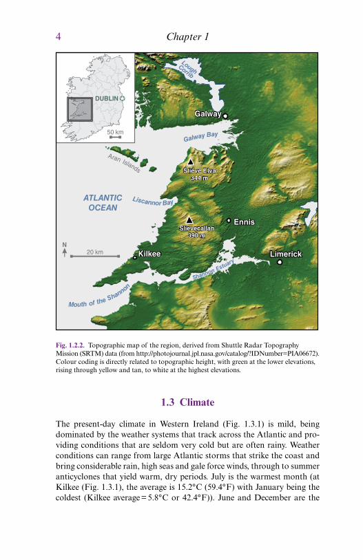
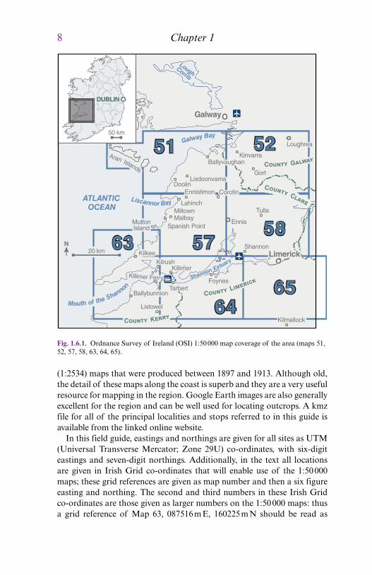
Vis
eacutean
Ser
pukh
ovia
nB
ashk
irian
Tou
rnai
sian
Cyclothem V Cyclothem V
Cyclothem IV Cyclothem IV
Doonlicky Cyclo Doonlicky Cyclo
Kilkee Cyclothem Kilkee Cyclothem
Tullig Cyclothem Tullig Cyclothem
Gull Island Fm RossGull Island Fm
Ross SandstoneFm
Clare Shale Fm
Clare Shale Fm
Magowna FmCorgrig Lodge Fm
Parsonage Fm
Shannagolden Fm
Durnish Fm
Rathkeale Fm
Waulsortian Limestone
Ballysteen Fm
Ballymartin Fm
Ringmoylan Shale Fm
Mellon House Fm
devresboton
Shannon N ClareShannon Estuary North County Clare
Central Clare GroupGIF
RossFm
ClareShale
ViseacuteanLimestones
WaulsortianLimestones
CourceyanLimestones
hiat
us
320Ma
350Ma
Pen
nsyl
vani
anM
issi
ssip
pian
Din
antia
n
Tou
rnas
ian
Vis
eacutean
Nam
uria
n Cen
tral
Cla
reG
roup
Sha
nnon
Gro
up
Bas
hkiri
anS
er
MARSDENIAN
KINDERSCOUTIAN
ALPORTIAN
CHOKIERIAN
ARNSBERGIAN
PENDLEIAN
BRIGANTIAN
ASBIAN
HOLKERIAN
ARUNDIAN
CHADIAN
COURCEYAN
Slievenaglasha Fm
Burren Fm
Tubber Fm
Fig 172 Summary of the Carboniferous lithostratigraphy in the Shannon Estuary and northern County Clare regions The right‐hand column shows a chronostratigraphic correlation between the southern Shannon sections and those in northern County Clare showing the substantial hiatus developed between the Viseacutean limestones and Clare Shale Ser is Serpukhovian
N County ClareShannon Estuary
Limestone types
Shallow bioclastic
Cherty muddy
Reef
DoonlickyCyclothemKilkeeCyclothem
TulligCyclothem
Gull Island
RossSandstone
ClareShale
ViseacuteanLimestones
Rathkealevolcanics
TournaisianLimestones
CourceyanLimestones
Asbian
Brigantian
Holkerian
Cyclothem V
Cyclothem IV
0 m
500
1000
1500
2000
2500
WaulsortianLimestones
Fig 173 Correlation of summary lithostratigraphic columns from the Shannon Estuary region and northern County Clare sections ~ 50 km to the north This diagram shows the substantial lateral thickness variations at the level of the Clare Shale Ross Sandstone and Gull Island formations and much less lateral variation at other levels
14 Chapter 1
models of sedimentary fill that have been proposed for the Shannon Basin (Chapter 3) The intention of these two chapters is to set the scene for readers as they use the field guide to examine the stratigraphy and sedi-mentology described in the following chapters After these two review chapters the sediments are subsequently detailed in eight chapters that progressively work up‐stratigraphy Each chapter presents details on a range of localities with a summary of these locations being shown in Fig 181 It is worthwhile to examine this map when planning an itinerary to the region as some parts of the stratigraphy detailed in separate c hapters may lie close to each other geographically in the field Fig 181 shows the
yaByawlaG
Liscan ynor Ba
yrautsEnonnahS
nonnahSehtfoMouth
ATLANTICOCEAN
LoughCorrib
20 kmN
Aran Islands
MuttonIsland
KillimerKilrush
Kilkee
TarbertBallybunnion
Listowel
FoynesKillimer Ferry
Doolin
Lahinch
SpanishPoint
Miltown Malbay
Ennistimon
Lisdoonvarna
Ennis
Tulla
Shannon
Kilmallock
Corofin
BallyvaughanKinvarra
Gort
Loughrea
Limerick
Galway
50 km
DUBLIN
CC
GC
KC
LC
4 Lower Carboniferous (Shannon Estuary)5 Lower Carboniferous (Burren)6 Clare Shales7 Ross Sandstone Formation
8 Gull Island Formation9 Tullig and Kilkee cyclothems (S Clare)10 Tullig and Kilkee cyclothems (N Clare)11 Younger cyclothems
Chapters
Fig 181 Overview map of the field localities detailed in this field guide
Introduction to the Field Guide 15
regions of occurrence of the localities detailed in each chapter and allows easy visual recognition of the overlap of the differing localities detailed herein
In addition to the figures printed in the hard copy of the field guide there are a range of online resources available on the linked field guide website (wwwwileycomgobestshannonbasin) These include1 Google Earth kmz Excel and text files of all outcrop locations (in UTM and Irish Grid co‐ordinates) subdivided according to Chapter These allow easy location of all the field stops detailed herein as well as some key access points to certain localities2 High‐resolution copies of all figures in the guidebook as PowerPoint slides These will allow users to utilise these diagrams in their own work in the field in teaching applications and also allow closer inspection of detail3 High‐resolution jpeg GigaPan photo‐montages for several key locali-ties that can be viewed to better examine the detail within these outcrops A listing of these GigaPan images with cross‐referencing to the appropri-ate chapters is also given in Appendix 14 A list of addresses for useful websites including the Ordnance Survey of Ireland Geological Survey of Ireland and various useful field contacts
16
A Field Guide to the Carboniferous Sediments of the Shannon Basin Western Ireland First Edition Edited by James L Best and Paul B Wignall copy 2016 International Association of Sedimentologists Published 2016 by John Wiley amp Sons LtdCompanion website wwwwileycomgobestshannonbasin
The Shannon Basin Structural Setting and Evolution
JOHN GRAHAM
Chapter 2
21 Introduction
During the mid‐Carboniferous around 330 million years ago the area around the modern Shannon Estuary of western Ireland provided signifi-cant accommodation for sediments that are now visible in spectacular coastal exposures This depositional basin has been referred to as the Shannon Trough the Shannon Basin the Clare Basin and the Western Irish Namurian Basin Despite the considerable interest in and study of the coastal exposures the geographical limits of this basin are very poorly constrained To the west the margins are under the Atlantic and geophysi-cal data on their location is equivocal To the south and the south‐east information is present but it has not been interrogated in detail partly due to limited exposure of the basin fill Whilst this does not affect many of the detailed studies that have occurred it does severely limit those that attempt to make larger scale reconstructions
In gross terms the succession represents progressive deepening through a lower carbonate portion a middle part dominated by deep water muds and then progressive shallowing through turbiditic sands and muddy slope sediments to deltas that have been proposed to bear close comparison to the modern Mississippi system The history contained in these rocks is of course more complex and more informative than this as the subsequent chapters will demonstrate Since the pioneering work of Dan Gill in the 1950s and 1960s these rocks have provided useful analogues for petroleum geologists and as such that they have become some of the most visited sections in the world The succeeding chapters discuss many aspects of this succession as well as guiding the reader to where the evidence can be seen
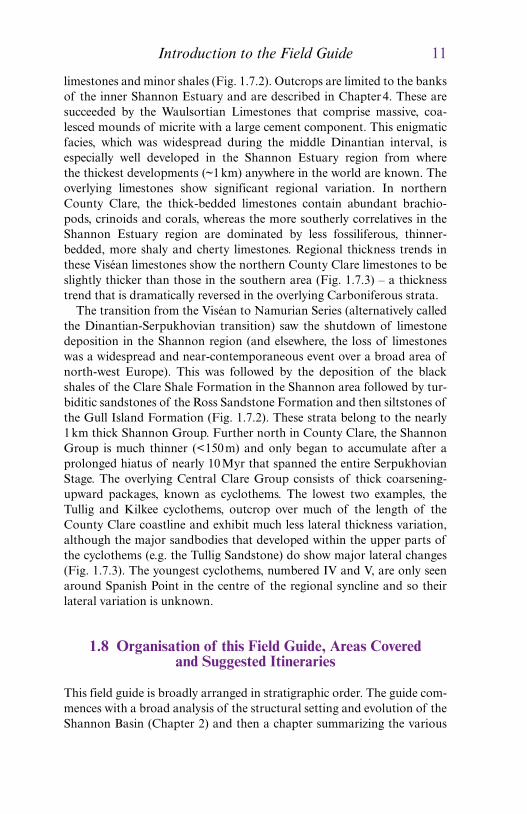
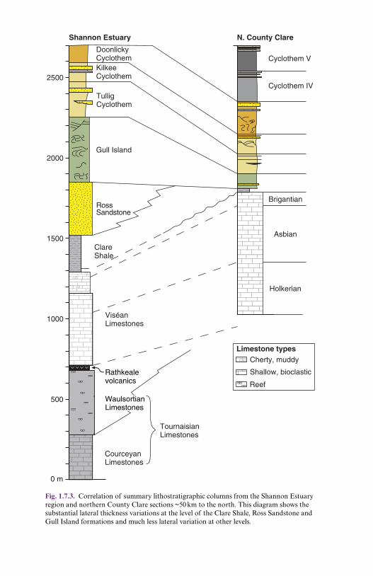