thesis report resized
TRANSCRIPT

SYNERGY
Tridti Patarakiatsan
Master ThesisDepartment of UrbanismFaculty of Architecture
BANGKOK BKKsSYNERGY
In support of: MSC3 UrbanismResearch& Design Methods (AR3U011), Theory of Urbanism (AR3U022), Graduation Lab (AR3U030)
MASTER THESIS TU DELFT BANGKOK SYNERGY 3BKKs2 COLOPHON
BANGKOK SYNERGYA synergetic spatial vision to preserve Bangkok heritage,
integrated with rapid mass transit system
Master ThesisTridti Patarakiatsan
Student ID [email protected]
Graduation StudioComplex cities
Department of UrbanismFaculty of Architecture
Delft University of Technology
Delft, the Netherlands, 2012
Mentor TeamDr. Lei Qu
Chair of Spatial Planning and [email protected]
Ir. Willem HermansChair of Urban Design
[email protected] of the visual information presented in this document has been collected from the sources listed below the items and reproduced by the author.When there is no source indicated, the authorship belongs to the author of this thesis.
MASTER THESIS TU DELFT BANGKOK SYNERGY 5BKKs4 FORWARD
DEVELOPMENT THAT PEOPLE MATTER
“The nature and shape of the future urban world is complex. Large and complex as it is, this is the arena where spatial plan-ners and designers should contribute to with their understand-ing of the way urban space is produced. It is their task to for-mulate tools and strategies to intervene and organize space in order to mediate disparate interests. ”
(Complex cities studio guidebook 2011)
For decades, city plans of Bangkok have been the preroga-tive of a few influential interest groups. Interests of the middle to upper class and more powerful groups have been protects and carelessly neglected the needs and interests of the low-er- income majority or other vulnerable groups, particularly those who live in unprofitable areas. The consequences of this approach can be seen in places, where a high propor-tion of population live in isolated areas lacking provision for basic infrastructure and services. In other words, when the city prioritizes global development towards efficiency and at-tractiveness, this exclusive approach results in segregation and fragmentation on the local level.
Without being integrated to the urban tissue, this undesirable truth has triggered the author’s interest in seeking for the way to change the paradigm in which local level especially the vulnerable groups will also be able to participate and benefit from global interventions by the government. Therefore, it is very significant to promote urban vitality that enhances not only their living quality, but also economic viability and social cohesion.
Thanks to the mass transit system (MTS) expansion plan of Bangkok launched by the government in last few years, the hypothesis of integrating global (infrastructure) into local dimensions (urban tissue) will be experimented. The thesis starts with a serious problem of the city brought by the MTS (elevated level) implemented on a fragmented and unorgan-ized urban spatial structure (ground level) of the city due to a rapid urbanization. Without any coordination to urban de-velopment, when the market begins to intervene, losers are local residents seen via gentrification, segregation and ineq-uity. However, in accordance to the expansion plan, it covers the historic core of the city, which is crucially needed to be preserved. This is a high time to reconsider and integrate not only global and local planning, but also urban and infrastruc-ture development towards sustainability.
By planning for local inhabitants, the inclusive approach aims to prepare for the undeniable infrastructure development to meet local demands and basic services before it comes and to make use of it when it finishes to improve spatial quality and to enhance socio-cultural dimensions together with eco-nomic conditions. To conclude, the author will focus on the local level and search for an appropriate linkage with the glo-bal planning by using the MTS network expansion and the historic core of Bangkok as the study case.
Due to the limitation of the study time at TU Delft, a year of the graduation project has been come to a close. However, the author and the mentor team hope the thesis project, Bangkok Synergy, is a starting point to change the way of thinking in planning between global - local dimensions and urban and infrastructure development especially in Bangkok or other similar developing countries. With a support by the gradua-tion lab “complex cities”, the report consists of both research and design process. It deals with a challenge of complexity and uncertainty in planning and seeks for an opportunity to test the hypothesis, in this case is integration between the MTS network expansion and the historic core of Bangkok.
By sharing my discovery, this project is just a start of a new way of thinking. The author hopes if the project helps shaping the society more or less, the thesis has already accomplished its mission. Lastly, wish readers enjoy reading this book and inspire readers to contribute positively to your own city too.
Tridti Patarakiatsan17-06-2012
BKKs6 MASTER THESIS TU DELFT BANGKOK SYNERGY 7
01
04
INTRODUCTION AND PROBLEM FIELD
02THEORETICALRESEARCH
03CONTEXT RESEARCH
AND ANALYSIS
EMPIRICAL RESEARCH
1. Motivation
2. Principles and objectives
3. Problem statement
4. Aim
5. Research questions
6. Relevance
7. Methodology
8. Time working plan
10
12
13
14
15
16
17
22
88
90
98
101
104
108
110
27
31
38
40
41
114
116
126
134
142
46
52
57
58
60
61
62
64
152
154
156
157
158
70
76
78
79
80
81
162
164
165
166
167
168
1. Theories related the MTS
2. Theories related heritage
3. Urban vitality indicators
4. Conclusion
5. Bibliography for the theory part
1. City profile
2. Historic development
3. Infrastructure development
4. Planning system
5. Relation of two dynamics
6. A change in transport means
7. Gentrification by the MTS
8. Conclusion
1. Selection criteria
2. The strategic location
3. Spatial network fragmentation
4. From orchards to barriers
5. A limitation of local movement
6. Conclusion
05
08
STRATEGY
06STRATEGIC PROJECTS
07MANAGEMENT
STRATEGY
REFLECTION
1. Case study
2. Infrastructural network
3. Natural network
4. Tourist industries
5. Human network
6. Effect
7. Conclusion
1. Projects inventory
2. The station area
3. Transformed open space
4. The riverside areas
5. Local connections
1. Evaluation
2. Governance structure
3. Phasing
4. Stakeholders
5. Urban rules
1. Evaluation
2. City model review
3. Integrated actions
4. Possible side effects
5. Recommendations
6. Bibliography
CONTENT
THESIS STRUCTURE

BKKs8
Chapter 1
MASTER THESIS TU DELFT BANGKOK SYNERGY 9
Source : www.skyscrapercity.com
INTRODUCTION AND PROBLEM FIELD

BKKs10 MASTER THESIS TU DELFT BANGKOK SYNERGY 11
many theories about problems of scale and rapid devel-opment in that it causes spatial fragmentation (Graham, Marvin 2008) and can tear the city apart (Read 2001), with this rapid development, if we do not do it properly, it will be more likely to harm than benefit.However, it also provides a crucial opportunity and a big challenge to create a more sustainable transport mode, and at the same time, to prevent negative effects to the historic core of the city.
Conflicts under the inevitable infrastructure expansion Many cities conceptualize the idea to develop the rail system to create a node and, at the same time, still maintain “place” for the areas. Bertolini and Spit add as the renewal of existing fabric with a reason to deal with future demands with the notion of Transit- Oriented De-velopment (TOD). However, the historic areas are not on the list. Generally, TOD or the station plaza is applied in suburb or redeveloped areas. In the case of Bangkok, the capital city of Thailand, especially, the rail systems are built on the upper level through urban communities. In particular, in 2030, gov-ernment have already planned for the elevated rapid mass transit system (MTS) throughout the city, which will definitely cross the historic core of the city (see illustra-tion 1.3). Although the MTS plan has been announced, there is no in-depth research on how this big infrastructure plan will affect the vitality of the city, particularly historic areas, where their economic status and quality of life are low. The MTS, currently, could solve traffic problem, but there is still lacking of integration between MTS and urban fab-ric. As we have learnt a lot from the past experiences and
The threat of historic areas A historic city has organically developed through sev-eral decades. Their physical conditions are composed by fine-grains in terms of small plot sizes, passageways and the connection to local economic areas. The charac-ter and identity of historic areas will change dramatically from the past when new mode of transport has been implemented. Although, a number of optional modes of transport will increase to serve modern needs, such as new functions, the rapid change might negatively af-fect old living patterns and activities leading to a lost in “place” ( Bertolini and Spit, 1998). The most explicit structure is local streets (see illustration 2). In the past, it functions responding to small areas, but when the ac-cessibility has improved, it has to serve an increasing number of traffic as well. Consequently, when the size is not in a proportion with demands, which requires more spaces, it causes an expropriation in areas both along local roads ,connecting to stations, and around stations (transit area services).
Mode of transportation : the rail transport systemNowadays, in the rapid urbanized period, the develop-ment of the rail transport network, stations and transit nodes become a crucial strategy to develop city areas. To make it function effectively, the rail transport should be accessed easily. Particularly, it should be possible to get to by multi- modes of transport, such as, by car, bus or walk. At the same time, the service facilities should be provided, i.e., parking spaces and sub public trans-port stations (APA, 2006). Moreover, the development also magnets new activities into the areas, such as, new functions, people and so on. The consequence is that the role of the areas would be redefined. New infrastruc-tures developments would be created in order to serve those activities, which make the areas livelier as Berto-lini and Spit name the station as place (1998). However, the way city build the rail transport is limited by space, particularly in the case of elevated rail tracks leading to negative effects to the nearby areas (see illustration 1). The character of Bangkok is that it was planned on the elevated level, plugging in to global functions like de-partment stores and high class hotels and disengage to the lower world functionally and physically.
1.1 MOTIVATION
Illustration1 .2 the current condition of local streets in Bangkok, Thailand ,Source : www.flickr.com
Illustration 1.1 the current condition of rail transport in Bangkok, Thailand,Source : www.flickr.com
Illustration 1.3 the plan for the mass transit system expansion of Bangkok in 2030 (the officially preserved area of Bangkok is in the light green color) ,Source : www.bts.co.th
BKKs12 BANGKOK SYNERGY 13
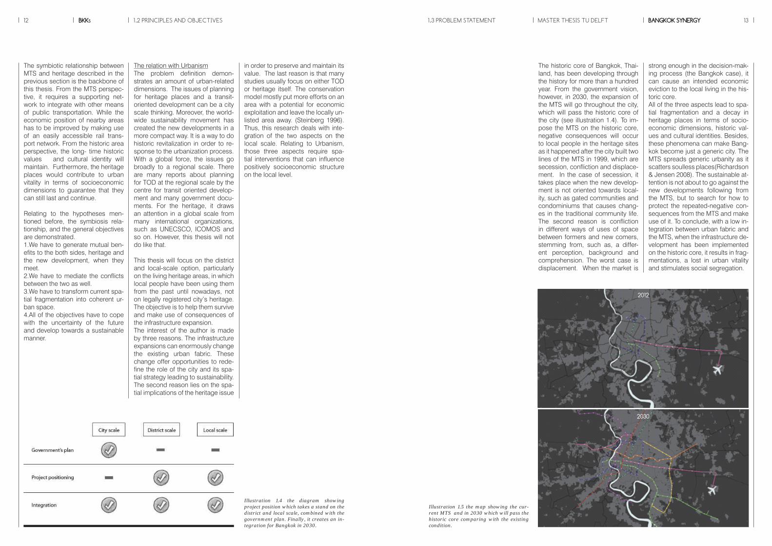
The historic core of Bangkok, Thai-land, has been developing through the history for more than a hundred year. From the government vision, however, in 2030, the expansion of the MTS will go throughout the city, which will pass the historic core of the city (see illustration 1.4). To im-pose the MTS on the historic core, negative consequences will occur to local people in the heritage sites as it happened after the city built two lines of the MTS in 1999, which are secession, confliction and displace-ment. In the case of secession, it takes place when the new develop-ment is not oriented towards local-ity, such as gated communities and condominiums that causes chang-es in the traditional community life. The second reason is confliction in different ways of uses of space between formers and new comers, stemming from, such as, a differ-ent perception, background and comprehension. The worst case is displacement. When the market is
strong enough in the decision-mak-ing process (the Bangkok case), it can cause an intended economic eviction to the local living in the his-toric core. All of the three aspects lead to spa-tial fragmentation and a decay in heritage places in terms of socio-economic dimensions, historic val-ues and cultural identities. Besides, these phenomena can make Bang-kok become just a generic city. The MTS spreads generic urbanity as it scatters soulless places(Richardson & Jensen 2008). The sustainable at-tention is not about to go against the new developments following from the MTS, but to search for how to protect the repeated-negative con-sequences from the MTS and make use of it. To conclude, with a low in-tegration between urban fabric and the MTS, when the infrastructure de-velopment has been implemented on the historic core, it results in frag-mentations, a lost in urban vitality and stimulates social segregation.
The relation with UrbanismThe problem definition demon-strates an amount of urban-related dimensions. The issues of planning for heritage places and a transit-oriented development can be a city scale thinking. Moreover, the world-wide sustainability movement has created the new developments in a more compact way. It is a way to do historic revitalization in order to re-sponse to the urbanization process. With a global force, the issues go broadly to a regional scale. There are many reports about planning for TOD at the regional scale by the centre for transit oriented develop-ment and many government docu-ments. For the heritage, it draws an attention in a global scale from many international organizations, such as UNECSCO, ICOMOS and so on. However, this thesis will not do like that.
This thesis will focus on the district and local-scale option, particularly on the living heritage areas, in which local people have been using them from the past until nowadays, not on legally registered city’s heritage. The objective is to help them survive and make use of consequences of the infrastructure expansion.The interest of the author is made by three reasons. The infrastructure expansions can enormously change the existing urban fabric. These change offer opportunities to rede-fine the role of the city and its spa-tial strategy leading to sustainability. The second reason lies on the spa-tial implications of the heritage issue
in order to preserve and maintain its value. The last reason is that many studies usually focus on either TOD or heritage itself. The conservation model mostly put more efforts on an area with a potential for economic exploitation and leave the locally un-listed area away. (Steinberg 1996). Thus, this research deals with inte-gration of the two aspects on the local scale. Relating to Urbanism, those three aspects require spa-tial interventions that can influence positively socioeconomic structure on the local level.
The symbiotic relationship between MTS and heritage described in the previous section is the backbone of this thesis. From the MTS perspec-tive, it requires a supporting net-work to integrate with other means of public transportation. While the economic position of nearby areas has to be improved by making use of an easily accessible rail trans-port network. From the historic area perspective, the long- time historic values and cultural identity will maintain. Furthermore, the heritage places would contribute to urban vitality in terms of socioeconomic dimensions to guarantee that they can still last and continue.
Relating to the hypotheses men-tioned before, the symbiosis rela-tionship, and the general objectives are demonstrated.1.We have to generate mutual ben-efits to the both sides, heritage and the new development, when they meet.2.We have to mediate the conflicts between the two as well.3.We have to transform current spa-tial fragmentation into coherent ur-ban space.4.All of the objectives have to cope with the uncertainty of the future and develop towards a sustainable manner.
1.2 PRINCIPLES AND OBJECTIVES MASTER THESIS TU DELFT1.3 PROBLEM STATEMENT
Illustration 1.4 the diagram showing project position which takes a stand on the district and local scale, combined with the government plan. Finally, it creates an in-tegration for Bangkok in 2030.
Illustration 1.5 the map showing the cur-rent MTS and in 2030 which will pass the historic core comparing with the existing condition.
2012
2030

BKKs14 MASTER THESIS TU DELFT BANGKOK SYNERGY 15
In order to be able to understand the key elements of the main research question, six sub research question need to be formulated.1. What are benefits and conflicts of the combination of historic and new developments? 2. What is the collective network of these two developments? (to define: what kind of co-using spaces and sharing functions? Which corridors need to be strengthened?)3. What are strategies for urban heritage conservation in relation with the infrastructure expansion?4. What is the role of the heritage places in 2030, when the mass transit comes?5. What kind of spatial design tools are able to integrate physical linkages between the heritage and new development in a sustainable way?6. How to transform the heritage sites towards socioeconomic viability ?
Due to Bangkok has been formed by a market led development; an in-tervention usually is made from the top-down level, which always gives a priority to infrastructure develop-ment. The integrated approach is missing in a connection with the existing urban form. Therefore, the research questions arise from soci-oeconomic and spatial dimensions. This integrated model, between old and new developments, creates two challenges. The first challenge is to exploit the new development by the MTS towards sustainability. The sec-ond challenge is how to protect liv-ing heritage from the negative result. The aim is to achieve them both.
How to preserve the existing historic core of Bangkok when the mass transit system imple-mentation, at the same time enhancing social cohesion and economic viability?
What kind of the strategic plan and spatial in-terventions can be applied on the historic core of Bangkok in order to deal with potentials of spatial quality improvement and integrate it with the MTS in 2030?
Mutual benefit and sustainable ap-proachThe aim of the project is to propose a strategy for the historic areas of Bangkok while integrating it with the expansion of MTS. The future vision of the project does not replace the old with the new developments, but takes a stand on that both process-es have their own dynamics. Thus, the strategy would combine two de-velopments and create a vision that the two are complementing each other. For the historic areas, the heritages need to be preserved and given a framework towards social and economic sustainability. The optimise uses of MTS to link uncon-nected areas and to create better liv-ing environment with improved pub-lic amenities would be proposed. In terms of the new development, new comers will benefit from the pro-
posal and help strengthening the local economic and social viability. Eventually, the synergetic spatial vi-sion will fill in the gap from the gov-ernment plan and provide a solution to solve this widespread problem of the city and work as a pilot project reflecting on the improvement of urban form, socioeconomic issues within a sustainable manner(see il-lustration 1.6)
1.4 AIM 1.5 RESEARCH QUESTIONS
Illustration 1.7 an approach summarized from the current conditions of Bangkok
Illustration 1.6 a sustainable model from triple P to Quadruple P (Duijvestein 2008)
Fact
Identity
Historic value
Social status
Economic status
Consequence Opportunities

BKKs16 MASTER THESIS TU DELFT BANGKOK SYNERGY 17
Societal relevanceThe relevance of the thesis lies in the fact that we have to deal with societal challenges of the current condition of Bangkok to prepare a solution when the MTS meets the historic core. Nowadays, there is a demand from local people to protect their communities from the market that wants to develop the areas around the MTS. However, the market also can financially sup-port the existing area by improving connectivity, public amenities and living quality. For that reason, this research tackles with the general-unsolved problem of Bangkok. It provides an integrated approach, which works as a pilot project, in or-der to generate mutual benefits and minimize social problems of the city.
Scientific RelevanceThis research will reflect on aca-demic debates on the spatial inter-vention and strategic planning for both the rail transport expansion and heritage conservation planning. In academic field, many researches have been done to sustainably pre-serve heritage. However in the de-veloping countries, when market becomes more dominant, preserva-tion plans cannot be enacted suc-cessfully as plans. Besides, to as-sure positive results, this research contributes to urban vitality, which, in this case, is an integration of liv-ing heritage and the MTS as a main component. Based on the different context of each city, another contri-bution of this thesis will stimulate a new approach to other cities to re-think and search for a new way to preserve its heritage to cope with an urbanization process.
Ethical ProblemsThe problem related to ethical is-sues arises in two cases. In heritage sites,the first is the limitation of con-servation areas, “enclave tourism” (Healy 1992). It occurs when the type and location of facilities are not oriented towards locality. As a re-sult, money will not benefit the local economy. This leads to an increase inflationary pressure on local econ-omy. Price of land, products are neither affordable nor responsive to local needs .It leads to a loss of sov-ereignty for locals, which translates, into loss of control in decision-mak-ing and benefits. Every area is differ-ent so that it will experience uneven distribution in conservation efforts. The outsider gains less favours and will see a rise in economic decay and fabric deterioration, while fo-cused areas receive priority aids. The second reason is observed in the style of approaching areas. From the policy level, it usually takes action on improving physical projects rather than social and eco-nomic dimension of the areas. From the past experiences of Bangkok, when the city faces with new infra-structure development, the project generally gives priority to land devel-opment and new construction rather than the conservation of the existing historic communities. Therefore, this thesis aims to not only create mu-tual benefits two new development and heritage places, but also try to mediate negative effects to locals, such as an expropriation and gen-trification.
1.6 RELEVANCE 1.7 METHODOLOGY
The research focuses on the case of living heritage that will face with the MTS expansion based on certain rea-sons.
1. Living heritage, in the historic places, contain-ing historic value, is still in use, has a certain degree of maturity as a social, cultural and economic entity. It pos-sesses certain qualities that best signify the dynamics of characters of the historic core.
2. Living heritage settles heavily along the former mode of transportation, mainly water, and usually close to new development areas, mostly high-rise and a gate community. It is an example of urban polarization of the city. With its historic value, it is a challenge by the con-temporary economic pressure by the market interests came with the MTS.
3. The configuration of function reflects the type of activities, which are commonly found in every old dis-tricts of the city, characterized by a large percentage of economic activities run by informal sectors.
4. Living heritage is not protected by laws as of-ficially registered ones. Besides, in the area itself, it still has traditional characters like low income, high density, and lack of accessibility to public amenities. The thesis aims at seeking for a sustainable way to develop the liv-ing heritage of the city.
The selection of the study case and the limitation of the researchThe historic core of Bangkok is chosen as the study case. Thailand is one of the developing countries in Asia that is facing the spatial and socio-economic transformation. It displays characters of urban problems in developing countries, which are facing with negative consequences from the infrastructure development, such as interven-tions from the market and infrastructure breakdowns on a local level, urban planning and governance failure. Al-though the city has been developing for hundreds years, it still does not plan to coordinate and integrate between infrastructure and urban development.The city of Bangkok has many heritage and high historic value. A number of local people and traditional commu-nities still live in the historic core of the city. The research recognizes the different types of heritage that the city has. Due to its complexity and character individuality, a different type of heritage sites deserves a specific ap-proach, which suits their situation.The thesis focuses on the producing a set of strategy and recommendation that will be able to help planner and decision makers to tackle with the MTS in the his-toric core. The result also paves the way to an integrated strategy to different individual case of heritage site. How-ever, the research will focus on only one types of herit-age, living heritage, to be demonstrated in the thesis. By narrowing down to only one case, the author can do analysis in detail and deeper levels.
Images showing recent social protests against an expropriation,resulting from interventions by the market, influenced by the MTS expansion, which invaded into traditional commercial communities in 2011, Source : http://www.prachachat.net
BKKs18 MASTER THESIS TU DELFT BANGKOK SYNERGY 191.7 METHODOLOGY
Products-Theoretical underpins for the as-pect related to the issue-A historic overview for the city of Bangkok-Developing criteria for choosing strategic locations
MAPPING THE CURRENT CONDI-TION ON THE LIVING HERITAGE IN THE HISTORIC CORE OF THE CITYThe second part of the research will study the existing conditions of the two fields. From the heritage field, it will study on the local network of the core, which needs to be kept and enhanced in terms of spatial, eco-nomic and social dimensions. The second one is from the MTS. It will link to the first field in term of opti-mise uses and minimized unwanted results of the MTS. The thesis pro-vides a synergetic vision for 2030, so a review on their potentials is necessary. The result will build an approach to deal with the project and design tools in the design pe-riod.Methods-Mapping on current social, eco-nomic and spatial condition-Interview local residents in order to know the local network and how they use space-Space syntax in order to discover spatial condition and level of inte-gration of the city and the area-GIS to analyse and calculate data and statisticProducts-An understanding on the MTS im-pact-An overview on the existing social, economic and spatial issue of the living heritage expressed in built en-vironment-A toolbox that can be used in the design phase
POSSIBLE SCENARIOS IN THE RE-LATION OF THE TWO DEVELOP-MENTSThe purpose of this part is to search for successful strategies that can apply to the city of Bangkok. Be-sides the MTS takes twenty years to function, 2030, which the situa-tion can changes. Particularly, in the city that the market is most powerful
among the other sectors, the sce-nario will be set up based on the possible conditions between the market and conservation planning. By dividing into two scenarios, the first one is extreme case, while the second is the moderate case. Methods-Case study of the car based cities in order to know the possible strat-egy to be applied to Bangkok-Literature review -Research by designProducts-Vision and Strategies base on prob-able scenarios
AN INTEGRATED PLAN BETWEEN HERITAGE AND THE MTS Based on previous research, a de-sign will be created for the project area. The design will redefine the role of heritage places in 2030 and improve the current situation to-wards the long-term development. The aim is to make use of the MTS and its consequence and maintain the historic value of the city and cur-rent fragmentations solved. The re-sult of this thesis can be seen via a design on spatial intervention on the local scale as a pilot project that will create a sustainable future.Methods-Drawing-Design research-Mapping-VisualizationsProducts-Specific intervention proposals based on the toolbox and criteria-Integration of the existing situation of the historic core with the MTS to create mutual benefits-Master plan for the area
The method of empirical researchThe research model is created in a relation to the research ques-tion. Various steps of the research model contribute to the challenges from research questions. The first step represents the research part of the thesis. It consists of three inde-pendent parts and the results will be combined in order to design in the design phase later on.The design phrase will start from the sub research question four to six by proposing spatial intervention for the living heritage in the area of his-toric core of the city of Bangkok. The research model contains four sepa-rate parts to be explained, but the time phrasing will overlap. The rela-tion and design phrase is not one-way direction, but it is woven and can be changed over research(see illustration 1.8). However, time schedule will be explained later on.
A COMPREHENSION: THE RE-LATIONSHIP BETWEEN THE UR-BAN DEVELOPMENT AND INFRA-STRUCTURE EXPANSIONS OF BANGKOK. The first part of research will focus on the relation between the two de-velopments. It describes the issues from the history, because it will give a better understanding as they are currently. The historic development will be analysed since the city has formed as the capital city in a form of maps. Another reason is to know the benefits, conflicts and driving forces which already happened, and at the same time where has a high chance to be preserved and the risky one to be destructed. In relation to the design phrase, the purposed intervention will be done in terms of living heritage conserva-tion, which is necessary to antici-pate threats and potentialities.MethodsA review through the history in a re-lation between the urban and infra-structure development, and at the same time searching for the conse-quence of the current MTS after an implementation in 1999-Literature review-Mapping-Historic research
Illustration 1.8 am empirical research model
Research Design
How to preserve the existing historic core of Bangkok when the mass transit system implementation, at the same time enhancing social cohesion and economic viability?
What kind of the strategic plan and spatial interventions can be applied on the historic core of Bangkok in order to deal with potentials of spatial quality improvement and integrate it with the MTS in 2030?
An integrated model for Bangkok in 2030
Intervention
The relationship between the urban development and i n f r a s t r u c t u r e expansions of Bangkok.
Mapping the current condition on the living heritage in the historic core of the city
Possible scenarios in the relation of the two develop-ments
An integrated plan between heritage and the MTS
Result
An overview on History and theory
Context researchCase study
Vision Strategy Design tools Design criteria
Outcome
What are bene�ts and con�icts of the combination of historic and new developments?
What are strategies for urban heritage conservation in relation with the i n f r a s t r u c t u r e expansion?
What is the collec-tive network of these two develop-ments?
What is the role of the heritage places in 2030, when the mass transit comes?
What kind of spatial design tools are able to integrate physical linkages between the heritage and new development in a sustainable way?
How to transform the heritage sites towards socio-economic viability?
Sub research questions
Main research questions

BKKs20 MASTER THESIS TU DELFT BANGKOK SYNERGY 21
The historic core of Bangkok, Thailand
Con�iction between new and traditional developments
The mass transit expansion and heritage conservation
Problem statement
A synergetic vision, integrated the MTS with heritage conservation
Objective
Research question
Target location Topic
Theoretical framework
Hypothesis
Vision
Empirical framework
District scale
City scale
Historial analysisCurrent situation
Spatial analysisSocio-economic analysis
Reference projects
Evaluation potential
transferable model
Strategies
Design
Evaluation
Evaluation
Literature study
LITERATURE STUDY DESIGN
City scale
Site analysis
The role, potential and general identity of the infrastructure expansion and heritage consear-vation
Future role, potential and unique identities of Bangkok
The historic core of Bangkok Scale
The role, potential and general identity of the infrastructure expansion and heritage consear-vation
Analysis on urban condition of the historic core of Bangkok
Mapping spatial and socio-economic problem on strategic locations.
Theoretical underpin on the relatioship between the MTS and heritage conservation.
Literature review1.MTSa. Network cityb. Mobilityc. TOD2. Heritagea. Conservationb. Heritage tourismc. urban vitality3. Historical researcha. Urban developmentb. Planning systemc. Infrastructure development
Literature review1. Gentri�cation in Bangkok2. Traditional settlements3.Accessibility4.A good node5.Place making6.Role of government in conservation planning
Mapping in order to know current conditions of the city1. Urban development2. Government vision3. Spatial condition; infrastruc-ture, open space4. Economic status5. Social dimension; population, density6. Land use
Revitalization approach for living heritage sites towards sustainability
A synergetic strategy regard-ing new development from the MTS; function and typol-ogy and local bene�ts; public amenities and connectivity improved
A vision for an integration between the MTS and historic areas
MappingSelection criteria to seek for strategiclocations to be intervened1. Spatial conditions : study on network connectivity and potential to integrate2. Economic status : search for the area which endangers by negative e�ects by the rapid development 3. Social status : look for the area that tends to be segregated after the implementation4. Historic value : investigate the area which has high value
Literature review1. Thai successful space2. Cultural landscape3. Spatial indicators of urban vitality
Mapping1. Infrastructural network2. Natural network3. Built environment
District scale
Local scale
1.7 METHODOLOGY
Illustration 1.9 the research model
BKKs22 MASTER THESIS TU DELFT BANGKOK SYNERGY 23
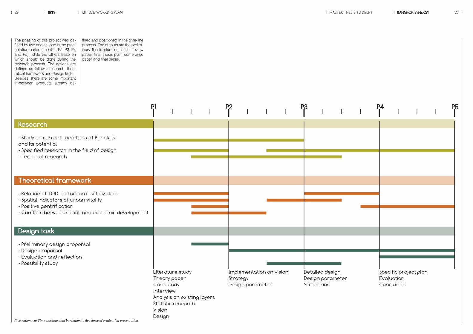
fined and positioned in the time-line process. The outputs are the prelim-inary thesis plan, outline of review paper, final thesis plan, conference paper and final thesis.
1.8 TIME WORKING PLAN
Illustration 1.10 Time working plan in relation to five times of graduation presentation
The phasing of this project was de-fined by two angles; one is the pres-entation-based time (P1, P2, P3, P4 and P5), while the others base on which should be done during the research process. The actions are defined as follows; research, theo-retical framework and design task. Besides, there are some important in-between products already de-
Literature studyTheory paperCase studyInterviewAnalysis on existing layersStatistic researchVisionDesign
Research
- Study on current conditions of Bangkokand its potential- Specified research in the field of design- Technical research
P1 P2 P3 P4 P5
Theoretical framework
- Relation of TOD and urban revitalization- Spatial indicators of urban vitality- Positive gentrification- Conflicts between social and economic development
Design task
- Preliminary design proporsal- Design proporsal- Evaluation and reflection- Possibility study
Implementation on visionStrategyDesign parameter
Detailed designDesign parameterScrenarios
Specific project planEvaluationConclusion

BKKs24
Source : www.skyscrapercity.com
MASTER THESIS TU DELFT BANGKOK SYNERGY 25
Chapter 2THEORETICAL RESEARCH
BKKs26 MASTER THESIS TU DELFT BANGKOK SYNERGY 27
For the heritage field, it links to first-ly, the theory about living heritage. The second one is about how to make use of the heritage conser-vation. In this globalized era, cities call for economic attractiveness and competition. The heritage commer-cialization becomes an approach, which has tourism as a main player to support financially. The last urban related theory is about urban vitality, which will guarantee that heritage will not only be kept, but also func-tion sustainably in the long run.The last past embodies on the com-bination of the two dynamics, the MTS and heritage, towards urban vitality. The spatial indicators will be unfolded and will be applied for the design part later on.
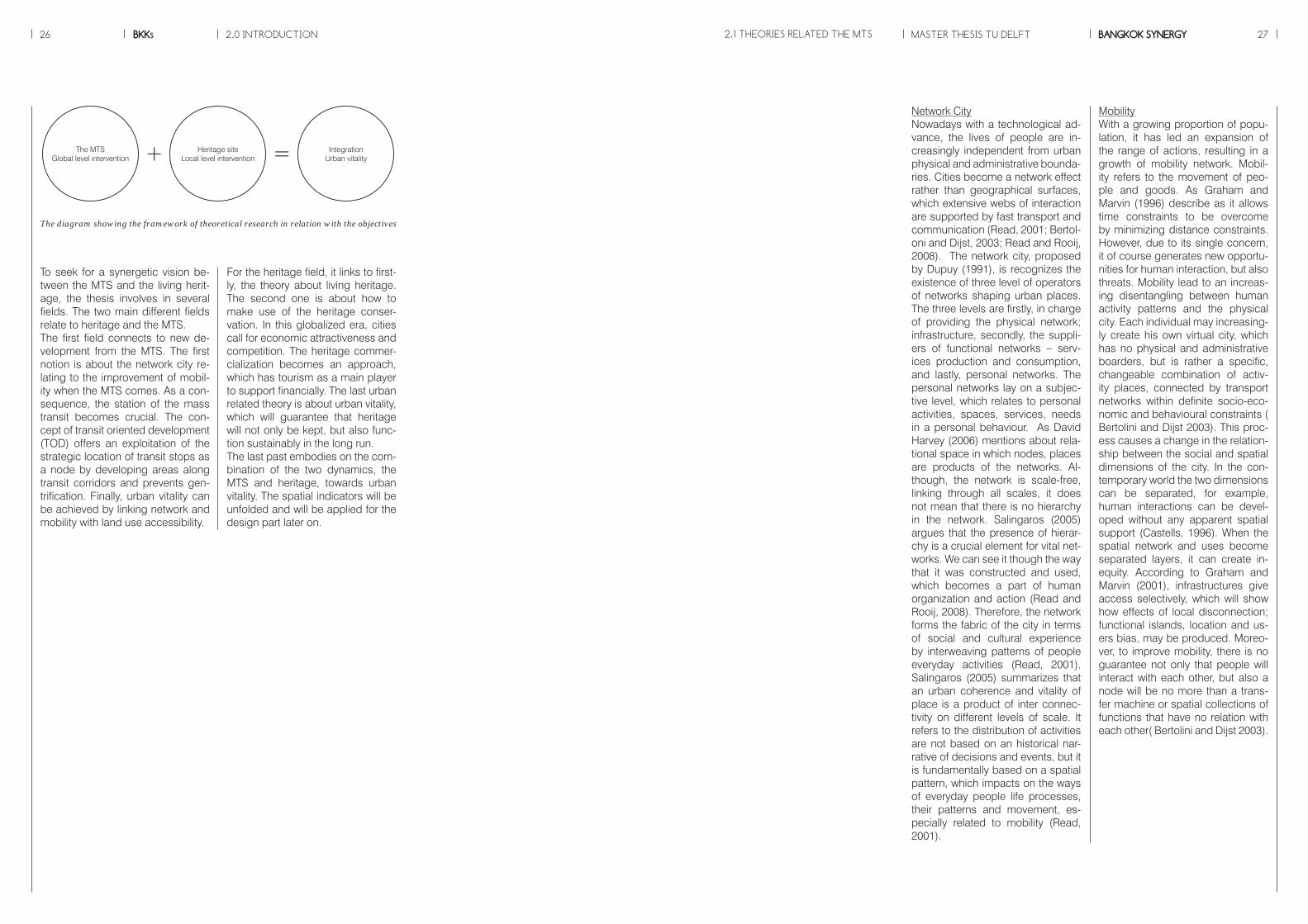
To seek for a synergetic vision be-tween the MTS and the living herit-age, the thesis involves in several fields. The two main different fields relate to heritage and the MTS. The first field connects to new de-velopment from the MTS. The first notion is about the network city re-lating to the improvement of mobil-ity when the MTS comes. As a con-sequence, the station of the mass transit becomes crucial. The con-cept of transit oriented development (TOD) offers an exploitation of the strategic location of transit stops as a node by developing areas along transit corridors and prevents gen-trification. Finally, urban vitality can be achieved by linking network and mobility with land use accessibility.
2.1 THEORIES RELATED THE MTS
MobilityWith a growing proportion of popu-lation, it has led an expansion of the range of actions, resulting in a growth of mobility network. Mobil-ity refers to the movement of peo-ple and goods. As Graham and Marvin (1996) describe as it allows time constraints to be overcome by minimizing distance constraints. However, due to its single concern, it of course generates new opportu-nities for human interaction, but also threats. Mobility lead to an increas-ing disentangling between human activity patterns and the physical city. Each individual may increasing-ly create his own virtual city, which has no physical and administrative boarders, but is rather a specific, changeable combination of activ-ity places, connected by transport networks within definite socio-eco-nomic and behavioural constraints ( Bertolini and Dijst 2003). This proc-ess causes a change in the relation-ship between the social and spatial dimensions of the city. In the con-temporary world the two dimensions can be separated, for example, human interactions can be devel-oped without any apparent spatial support (Castells, 1996). When the spatial network and uses become separated layers, it can create in-equity. According to Graham and Marvin (2001), infrastructures give access selectively, which will show how effects of local disconnection; functional islands, location and us-ers bias, may be produced. Moreo-ver, to improve mobility, there is no guarantee not only that people will interact with each other, but also a node will be no more than a trans-fer machine or spatial collections of functions that have no relation with each other( Bertolini and Dijst 2003).
Network CityNowadays with a technological ad-vance, the lives of people are in-creasingly independent from urban physical and administrative bounda-ries. Cities become a network effect rather than geographical surfaces, which extensive webs of interaction are supported by fast transport and communication (Read, 2001; Bertol-oni and Dijst, 2003; Read and Rooij, 2008). The network city, proposed by Dupuy (1991), is recognizes the existence of three level of operators of networks shaping urban places. The three levels are firstly, in charge of providing the physical network; infrastructure, secondly, the suppli-ers of functional networks – serv-ices production and consumption, and lastly, personal networks. The personal networks lay on a subjec-tive level, which relates to personal activities, spaces, services, needs in a personal behaviour. As David Harvey (2006) mentions about rela-tional space in which nodes, places are products of the networks. Al-though, the network is scale-free, linking through all scales, it does not mean that there is no hierarchy in the network. Salingaros (2005) argues that the presence of hierar-chy is a crucial element for vital net-works. We can see it though the way that it was constructed and used, which becomes a part of human organization and action (Read and Rooij, 2008). Therefore, the network forms the fabric of the city in terms of social and cultural experience by interweaving patterns of people everyday activities (Read, 2001). Salingaros (2005) summarizes that an urban coherence and vitality of place is a product of inter connec-tivity on different levels of scale. It refers to the distribution of activities are not based on an historical nar-rative of decisions and events, but it is fundamentally based on a spatial pattern, which impacts on the ways of everyday people life processes, their patterns and movement, es-pecially related to mobility (Read, 2001).
2.0 INTRODUCTION
IntegrationUrban vitality
The MTSGlobal level intervention
Heritage siteLocal level intervention+ =
The diagram showing the framework of theoretical research in relation with the objectives
BKKs28 MASTER THESIS TU DELFT BANGKOK SYNERGY 29
identity, such as a harbour city or an airport city (Bertolini and Slit, 1998).
2.1 THEORIES RELATED THE MTS
A good nodeAs APA gives a definition that a good node concerns with not only the sta-tion, but also transport-supported network, i.e., park and ride, pedes-trian network and service functions. Simpson (1994) illustrates impact of the development and station ar-eas on the city’s fabric. It can cause both positive and negative results. The positive aspects are firstly, the area of development will be ac-cessed easily, which causes chang-es in density and urban grain. From a good accessibility, it draws at-tention of people to come and use that will be able to improve the eco-nomic status of the existing area. The third reason is that it increases more transport options to residents, which will reduce numbers of pri-vately owned vehicle.On the other hand, a node can gen-erate negative consequences too. For example, existing activities and programmes will decline, due to new development from traffic nodes. It is easy to access, which will make ar-eas denser, mainly being occupied by new economic functions. All of new developments can replace the traditional living pattern so that it loses its role to the city and “place”.Many conflicts will happen if there is no effort to blend within the context. For example, new developments do not meet demands of existing peo-ple in terms of functions and uses.From above mention, a node can cause unwanted effects to the ex-isting fabric. To be a good node, it should maximize positive outcome and minimize the negative one. In other words, as Graham and Marvin (2001) mention that a mix in uses, functions and density are key solu-tions. Diversity can serve different demands from every social status, which leads to centrality of the area with a mix in land use and activities. It provides options to all ranges of social status and finally, enhances an effective transport network.
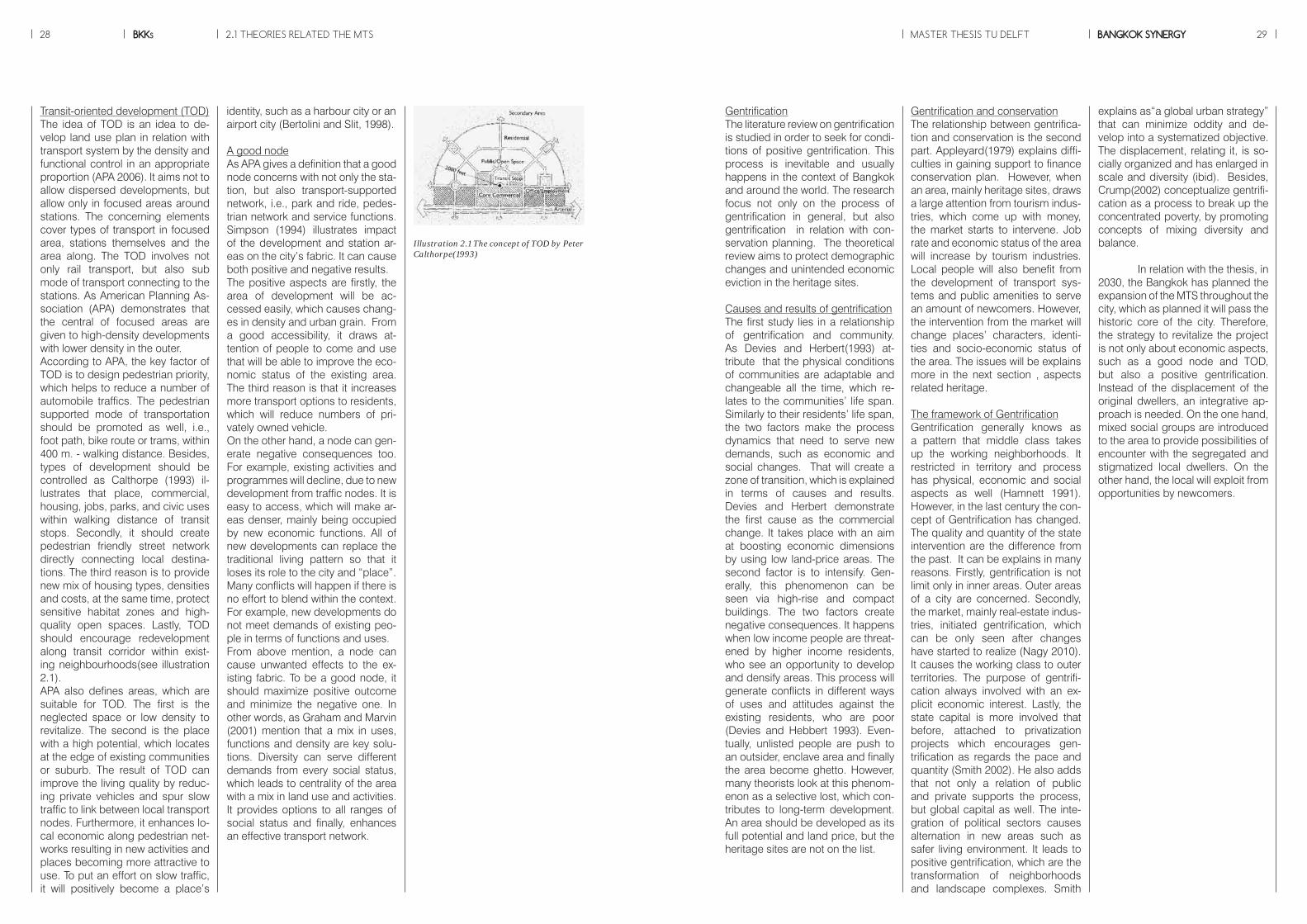
Transit-oriented development (TOD)The idea of TOD is an idea to de-velop land use plan in relation with transport system by the density and functional control in an appropriate proportion (APA 2006). It aims not to allow dispersed developments, but allow only in focused areas around stations. The concerning elements cover types of transport in focused area, stations themselves and the area along. The TOD involves not only rail transport, but also sub mode of transport connecting to the stations. As American Planning As-sociation (APA) demonstrates that the central of focused areas are given to high-density developments with lower density in the outer.According to APA, the key factor of TOD is to design pedestrian priority, which helps to reduce a number of automobile traffics. The pedestrian supported mode of transportation should be promoted as well, i.e., foot path, bike route or trams, within 400 m. - walking distance. Besides, types of development should be controlled as Calthorpe (1993) il-lustrates that place, commercial, housing, jobs, parks, and civic uses within walking distance of transit stops. Secondly, it should create pedestrian friendly street network directly connecting local destina-tions. The third reason is to provide new mix of housing types, densities and costs, at the same time, protect sensitive habitat zones and high-quality open spaces. Lastly, TOD should encourage redevelopment along transit corridor within exist-ing neighbourhoods(see illustration 2.1).APA also defines areas, which are suitable for TOD. The first is the neglected space or low density to revitalize. The second is the place with a high potential, which locates at the edge of existing communities or suburb. The result of TOD can improve the living quality by reduc-ing private vehicles and spur slow traffic to link between local transport nodes. Furthermore, it enhances lo-cal economic along pedestrian net-works resulting in new activities and places becoming more attractive to use. To put an effort on slow traffic, it will positively become a place’s
Illustration 2.1 The concept of TOD by Peter Calthorpe(1993)
Gentrification and conservationThe relationship between gentrifica-tion and conservation is the second part. Appleyard(1979) explains diffi-culties in gaining support to finance conservation plan. However, when an area, mainly heritage sites, draws a large attention from tourism indus-tries, which come up with money, the market starts to intervene. Job rate and economic status of the area will increase by tourism industries. Local people will also benefit from the development of transport sys-tems and public amenities to serve an amount of newcomers. However, the intervention from the market will change places’ characters, identi-ties and socio-economic status of the area. The issues will be explains more in the next section , aspects related heritage.
The framework of GentrificationGentrification generally knows as a pattern that middle class takes up the working neighborhoods. It restricted in territory and process has physical, economic and social aspects as well (Hamnett 1991). However, in the last century the con-cept of Gentrification has changed. The quality and quantity of the state intervention are the difference from the past. It can be explains in many reasons. Firstly, gentrification is not limit only in inner areas. Outer areas of a city are concerned. Secondly, the market, mainly real-estate indus-tries, initiated gentrification, which can be only seen after changes have started to realize (Nagy 2010). It causes the working class to outer territories. The purpose of gentrifi-cation always involved with an ex-plicit economic interest. Lastly, the state capital is more involved that before, attached to privatization projects which encourages gen-trification as regards the pace and quantity (Smith 2002). He also adds that not only a relation of public and private supports the process, but global capital as well. The inte-gration of political sectors causes alternation in new areas such as safer living environment. It leads to positive gentrification, which are the transformation of neighborhoods and landscape complexes. Smith
explains as“a global urban strategy” that can minimize oddity and de-velop into a systematized objective. The displacement, relating it, is so-cially organized and has enlarged in scale and diversity (ibid). Besides, Crump(2002) conceptualize gentrifi-cation as a process to break up the concentrated poverty, by promoting concepts of mixing diversity and balance.
In relation with the thesis, in 2030, the Bangkok has planned the expansion of the MTS throughout the city, which as planned it will pass the historic core of the city. Therefore, the strategy to revitalize the project is not only about economic aspects, such as a good node and TOD, but also a positive gentrification. Instead of the displacement of the original dwellers, an integrative ap-proach is needed. On the one hand, mixed social groups are introduced to the area to provide possibilities of encounter with the segregated and stigmatized local dwellers. On the other hand, the local will exploit from opportunities by newcomers.
GentrificationThe literature review on gentrification is studied in order to seek for condi-tions of positive gentrification. This process is inevitable and usually happens in the context of Bangkok and around the world. The research focus not only on the process of gentrification in general, but also gentrification in relation with con-servation planning. The theoretical review aims to protect demographic changes and unintended economic eviction in the heritage sites.
Causes and results of gentrificationThe first study lies in a relationship of gentrification and community. As Devies and Herbert(1993) at-tribute that the physical conditions of communities are adaptable and changeable all the time, which re-lates to the communities’ life span. Similarly to their residents’ life span, the two factors make the process dynamics that need to serve new demands, such as economic and social changes. That will create a zone of transition, which is explained in terms of causes and results. Devies and Herbert demonstrate the first cause as the commercial change. It takes place with an aim at boosting economic dimensions by using low land-price areas. The second factor is to intensify. Gen-erally, this phenomenon can be seen via high-rise and compact buildings. The two factors create negative consequences. It happens when low income people are threat-ened by higher income residents, who see an opportunity to develop and densify areas. This process will generate conflicts in different ways of uses and attitudes against the existing residents, who are poor (Devies and Hebbert 1993). Even-tually, unlisted people are push to an outsider, enclave area and finally the area become ghetto. However, many theorists look at this phenom-enon as a selective lost, which con-tributes to long-term development. An area should be developed as its full potential and land price, but the heritage sites are not on the list.

BKKs30 MASTER THESIS TU DELFT BANGKOK SYNERGY 31
Accessibility a key towards sustain-ability“The ultimate goal of most transpor-tation is “access,” people’s ability to reach desired goods, services and activities” (Litman, 2008). The definition of accessibility covers beyond mobility, because it includes not only improved mobility, but also improved land use accessibility, which reduces the distance between destinations. The objective refers to the ability to reach desired goods, services, activities and destinations so-called opportunities (Litman, 2008; Walker, 2011). Accessibility tends to optimized with multi-modal transportation and more compact mixed-use, walkable communities, which reduces an amount of travel required to reach destinations. This concept is similar to mobility envi-ronment or sustainable mobility by Bertolini and Dijst. They term mobil-ity environments as an anchoring human interaction in network cit-ies, which mean that in a boarder connotation accessibility is not just a feature of a transportation node (“ how many destinations, within which time and with which ease can be reached from an area”) but also of a place of activities (“how many and how diverse are the activities that can be performed in an are? “). Bertolini (1999) also widens it in that a place where many different people can come, but also where many dif-ferent people can do many different things: it is an accessible node, but also an accessible place. Read and Rooij (2008) emphasize in this issue by adding qualities brought to place by the connections. Houben (2003) in A Room with a View contributes that mobility are not only space for traffic ,but also public space, space to spend time in that being able to positively changed society and daily lives of people.
ITE Smart Growth Task Force (2003) summarizes the effect between land use patterns and accessibility in var-ious ways and these four aspects will be unfolded later on.
1. Density (number of people or jobs per unit of land area) increases the proximity of common destinations, and the number of people who use each mode, increasing demand for walking, cycling and transit.
2. Land use mix (locating different types of activities close together, such as shops and schools within or adjacent to residential neighbor-hoods) reduces the amount of travel required to reach common activi-ties.
3. Non-motorized conditions. The existence and quality of walking and cycling facilities can have a major effect on accessibility, particularly for non-drivers.
4. Network connectivity (more roads or paths that connect one geo-graphic area with another) allows more direct travel.
2.2 THEORIES RELATED HERITAGE
The theory, based on the idea of heritage, is presented in the form of a conference paper. It is used as a final product for the course theory of urbanism. The paper illustrates two aspects related heritage. The first part explains conflicts in conserva-tion in terms of spatial, economic and social factors. To assure that heritage sites will function prop-erly towards the long-term develop-ment, the paper uses the concept regarding urban vitality as indicators which are place making, functional approach and socio-economic se-curity. The aim of the paper is to seek for criteria, which can be used as a checklist in the design stage. The criteria tackles with four aspects related urbanism field; a good city form, life span of heritage places ex-tension, local benefits and the gov-ernance support.
2.1 THEORIES RELATED THE MTS
BKKs32 MASTER THESIS TU DELFT BANGKOK SYNERGY 33
1 The shift in conservation paradigmNowadays, due to the rapid growth in the size and the rapid transfor-mation forcing by globalization, the first priority of city development has shifted towards economic attrac-tiveness. Urban heritage becomes an economic asset. The condition of places of heritage is determined largely by their present function and use. The historic areas, which do not have a good potential for economic exploitation, for example through tourism, tend to decay rap-idly. In contrast, areas with urban heritage, which are still in use, has a better chance to be maintained (Steinberg 1996). Before the period of urban trans-formation for tourist consumption, urban heritage had needed to be given a definition. Generally, urban planners usually remarked on ob-jects, for instance, religious build-ings, castles, monuments and so on. The consensus often excluded the other features that help shape the society. Steinberg mentioned that historic residential areas and city centres equally represented the urban heritage as same as non-tangible elements, such as customs and beliefs, articulating the built environment. According to Nasser (2003), she also argues that historic context must be linked intrinsically to its past, not just in the continu-
ity of the built heritage and urban space, but also in the living culture that characterizes heritage places. However, the tourist consumption could cause a loss in local culture. With a commercial force to attract new comers, Berke and Conroy (2000) reveal that local culture is losing identities as global “cultural industries” asking for a redefinition and reinterpretation of their culture to be attractive and competitive. In the last decade, governments called
for “modernization” that only new modern housing was worthwhile and conversely anything old or in a traditional style was considered of little values and was torn down (Steinberg 1996). Moreover, spatial pattern of land uses and activities change, because of the new con-centration from the government. Although, international funds have been invested in maintaining gov-ernment owned and registered her-itage, in the case of privately owned properties, however, the situation is different. Private owners would con-sider any extra work as a burden due to the unaffordable cost and no necessities to maintain. Steinberg adds that they are unable to estab-lish other forms of use or innova-tive mechanisms, such as heritage “commercialization” for the financ-ing of the required conservation.
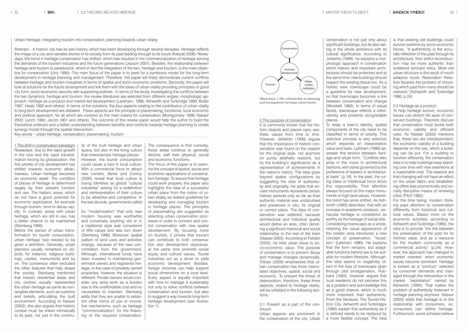
The consequence is that currently, these areas continue to generally decline, with their physical, social and economic functions. The focus of this paper is to exam-ine the concept of spatial, social and economic applications of conserva-tion heritage. To assure that heritage could work properly, the paper also highlights the idea of a successful urban place from the notion of ur-ban vitality as related guidelines for developing and managing tourism in heritage places. The principles of placemaking are suggested as selecting urban conservation proc-esses in order to connect and con-trol conservation with new spatial development. By focusing more on tourists, it proves that tourism can contribute to both conserva-tion and development objectives, at the same time promote social equity and cultural values. Tourist industries act as a driver to yield economic development. Besides, foreign incomes can help support social dimensions on a local level. Every aspect is equally important with how to manage it sustainably not only to solve conflicts between conservation and tourism, but also to suggest a way towards long-term heritage development (see illustra-tion 1).
Urban Heritage: Integrating tourism into conservation, planning towards urban vitality
Abstract – A historic city has its own history, which has been developing through several decades. Heritage reflects the image of a city and narrates stories of its society from its past leading through to its future (Karpati 2008). Nowa-days, the trend in heritage conservation has shifted, which has resulted in the commercialization of heritage serving the demands of the tourism industries and the future generations (Jepson 2001). Besides, the relationship between heritage and tourism is paradoxical, which in fact the integration of the two, heritage and tourism, is the main objec-tive for conservation (Urry 1990). The main focus of the paper is to seek for a symbiosis model for the long-term development in heritage planning and management. Therefore, the paper will firstly demonstrate current conflicts between heritage and tourism industries in terms of spatial and socio-economic problems. Secondly, the paper will look at solutions for the future development and link them with the ideas of urban vitality providing principles of good city form, socio-economic security with supporting policies . In terms of the study, investigating the conflicts between the two dynamics, heritage and tourism, the review literatures are selected from different angles, morphologic ap-proach, heritage as a product and market-led development (Lankham, 1996; Ashworth and Tunbridge 1990; Butler 1997; Healy 1992 and others). In terms of the solutions, the four aspects relating to the contribution of urban vitality to long-term development are debated. These aspects are the principle of placemaking, functional, local economic and political approach, for all which are covered as the main criteria for conservation (Montgomery 1998; Nasser 2003; Lynch 1960; Jacob 1961 and others). The outcome of this review paper would help the author to build the theoretical underpin and a better understanding between benefits and conflicts towards heritage planning to create synergy model through the spatial intervention. Key words – urban heritage; conservation; placemaking; tourism
2 The purpose of conservationIt is commonly known that the his-toric objects and places carry aes-thetic values from time to time. However, Jekilehto (1999) argues that the importance of historic con-servation was found on the respect for the original style, not anymore on purely aesthetic reasons, but by the building’s significance as a representation of achievements in the nation’s history. The idea goes beyond spatial configurations by suggesting the idea of authentic-ity and originality. He adds that an-cient monuments represents certain historic periods only so far as their authentic material was undisturbed and preserved in situ; its original or correct place. The idea of con-servation was widened, because architectural and historical quality would define an area, often denot-ing a significant historical and social relationship to the rest of the town (Nasser 2003). According to Feilden (2003), he links urban issue to so-cio-economic value. The purpose of conservation is to prevent decay and manage changes dynamically. Orbasi (2000) emphasizes that ur-ban conservation has three interre-lated objectives, spatial, social and economic. To prevent the threat of deterioration, therefore, these three aspects, related to heritage vitality, will be unfolded in the following sec-tions.
2.1 Present as a part of the con-tinuumUrban aspects are prominent in the conservation of the city. Urban
conservation is not just only about significant buildings, but its also tak-ing in the whole ambience with its cultural significance. According to Jokilehto (1999), he explains a mor-phologic approach in conservation which historic and important archi-tectures should be protected and at the same time, new buildings should respect the existing tissue too. As a holistic view, townscape could be a guideline for new development, so that townscape becomes a link between conservation and change (Worskett 1969). In terms of visual facets, townscape reflects a cities’ identity and presents recognizable places. To keep a town’s identity, spatial components of the city need to be classified in terms of priority. This selection process is very selective which depends on interpretation value and taste. Larkham (1996) as-sesses this tension between herit-age and urban form. “Conflicts also arise in the move in architectural fashions, with styles governed by the preference of leaders in architectur-al taste” (p.18). In the past, the rul-ing class or intellectual force drove this responsibility. Their attention always focused on the major monu-ments or high land values. However, the trend has since shifted. As Ash-worth (1990) describes, that with an increase in academic pressure, ver-nacular heritage is considered as worthy as the heritage of social elite. Considering townscape as a whole, retaining the visual appearance of the holistic area introduces a new concept of preservation, “facad-ism” (Larkham 1990). He explains that the form remains, but adapt-able functions behind are to be suit-able for modern lifestyles. Although, this idea seems to negatively di-rect in the loss of townscape grain through plot amalgamation, Hub-bard (1993), however, argues that local residents do not perceive this as a problem and acknowledge this as a good chance, which is much more important than authenticity. From the literature, The Tourist-His-toric City, Ashworth and Tunbridges (1990) explain that authenticity as it is defined needs to be replaced by a more flexible concept. The idea
is that existing old buildings could survive overtime by socio-economic forces. “If authenticity is the accu-rate reflection of the past through its architecture, then skilful reconstruc-tion may be more authentic than scattered remnant relics. Most old urban structure is the result of much adaptive reuse. Restoration there-fore facades the problem of choos-ing which past from many should be restored.”(Ashworth and Tunbridge 1990, p.24)
2.2 Heritage as a productTo help heritage survive, economic issues can stretch life span of con-served buildings. Theorists discuss that conservation must tackle both economic viability and efficient uses. As Nasser (2003) mentions that, these two are interdependent; the economic viability of a building depends on the use, which a build-ing can be put. For a building to function efficiently, the conservation idea is to help buildings keep stand-ing over time with new extentions at a reasonable cost. The reasons are that changing will not have an effect on the urban fabric and rehabilitat-ing offers less economically and so-cially disruptive means of renewing cities (Fitch 1982). For the time being, modern think-ing pays attention to conservation differently from historical and cul-tural values. Based more on the economic activities, according to Ashworth and Tunbridge (1990), the idea is to provide “the link between the preservation of the past for its intrinsic value, and as a resource for the modern community as a commercial activity” (p.24). How-ever, the approach has changed to market oriented, when economic issues become dominant. Heritage is looked as a “product” selected by consumer demands and man-aged through the intervention in the market, “exploitation” named by Ashworth (1994). That makes the problem of authenticity irrelevant in heritage planning anymore. Nasser (2003) adds that heritage is in the relationship with consumers, so, consumers can define heritage. Furthermore, some scholars believe
Illustration 1 The relationship in planning and management heritage conservation
2.2 THEORIES RELATED HERITAGE

BKKs34 MASTER THESIS TU DELFT BANGKOK SYNERGY 35
that heritage can be created just to give visitors pleasurable experi-ences (Newby, 1994), for example the idea of a copy, of which no origi-nal ever existed. Similarly, Larkham (1995) reveals “disneyfication” is the creation of an area based on a made up story to look authentic. As previously mentioned the shift in heritage conservation paradigm clearly shows the overall focus on the external dimension that tourism, being attracted by built heritage, could be an economic booster to lo-cal and national economy. Although, local residents can benefit from a wave of new comers, there is the other uncontrollable factor, which is “tourist area life cycle” (Butler 1997). He addresses that the destination is unknown and travelers come in small groups, because of a limita-tion in accessibility, supporting fa-cilities or local knowledge. However, after more tourists head to the area, it results in over capacity so that lo-cals cannot handle it, which causes congestion, social and environmen-tal problems on the way to historic resources degradation. The conse-quence is visitor decline and loss of satisfaction. Therefore, the problem relates to not only numbers of tourist in particular time, but also the con-sequence of tourist-related activities that stimulate negative changes in urban environment
2.3 The social conflicts between lo-cals and touristsTo make heritage as a key compo-nent for long-term development, Jacobs (1991) defines an objective as the capacity to accept demands without unacceptable changes. Norberg-Schulz (1985) discusses that conservation is meaningless without referring to locality. The lo-cal residents are disappeared in the concept described before. To meet local needs, Orbasi (2000) suggests conservation elements could be damaged or replaced by equivalent elements to ensure constant asset. However, it is not as simple when tourists become the main players for conservation. In fact, money from tourism industries can spread to local businesses and industries too. When cultural heritage turns out
to be a product depending on con-sumer markets, the consequence is that the market will choose strategi-cally the one with high commercial values (Ashworth 1994). The selec-tion process generates many prob-lems in conservation.Selectivity in conservation depends on who has a power to choose and where to be preserved. Conse-quently, when land uses changes along with conservation, it calls for transformation process. Jansen-Verbeke (1997) reveals that tourist activities cause an impact on the urban environments. He adds not only do tourist-related problems, such as, over crowdedness, traffic congestion or intrusion in private domains have a negative effect, but also local conservation bias does too. Moreover, with the number of visitors, finally the market starts to intervene. As Nasser (2003) illus-trates that the introduction of fast-food shops, car park facilities and standardized hotel represents a dis-tortion in what is required for local residents. Changing for the worse, “enclave tourism” (Healy 1992) oc-curs when the type and location of facilities are not oriented towards locality. As a result, money will not benefit the local economy. This leads to an increase inflationary pressure on local economy. Price of land, products are neither afford-able nor responsive to local needs creating an “outsider zone” (Nasser 2003) She attributes a loss of sov-ereignty for locals which translates into loss of control in decision-mak-ing and benefits. Every area is differ-ent so that it will experience uneven distribution in conservation efforts. The outsider gains less favors and will see a rise in economic decay and fabric deterioration, while fo-cused areas receive priority aids (Newby 1994). Not only is this considered a prob-lem, but also the different percep-tion in places between tourism and living culture, as well. According to Larkham (1995), locals are in dan-ger of becoming part of the spec-tacle of tourism or as “a market-oriented commodity”. Orbasi (2000) elaborates more practically that the conflict between residents and new-
comers takes place in altered use of space, such as private space, i.e., residential areas, as well as religious spaces, where they are the most sensitive to tourist intrusion. Tour-ism also causes changes in local lifestyles and cultures. An example, being that, tourism industries can destroy inherent meaning in deval-ued cultural items leading to a loss of local crafts (Furze et al. 1996).
3 Heritage conservation contribut-ing to urban vitalityIn the past, urban planners gener-ally located their perspectives on spatial conditions, such as in visual aesthetic or cities’ beatification. This was, until Lynch, in her book named The Image of the City (1960), men-tioned physical reality resulting in the place-making concept. Howev-er, the idea of vitality is not complete yet, because of lot of failure cases show that lacking of aspects related to socio-economics make the city unsustainable. In The Death and Life of Great American Cities by Jacobs (1961), she highlighted a good city idea in relation with uses. To be-come a vital place, densely concen-trated dwelling and economic units should be woven, providing com-ings and goings, which bring a place to life (Sternberg 2000). Particularly, Montgomery (1998), who reviewed on Lynch ideas, illustrated func-tional mixtures, diversity and adapt-ability as crucial ingredients for ur-ban vitality. At the same time, local transactions, fair distribution and controlled density are also socially important at the local level. Moreo-ver, a good city needs good govern-ance. Jacobs also mentioned that although markets are essential in providing financial support, markets can also undermine or even destroy urban vitality. It is necessary to get a support from government level to ensure that urban vitality will not be negatively intervened by the market mechanism. As already discussed in the earlier part, to solve the conflicts in con-servation, the following sections show the four aspects are equally important relating to heritage (see illustration 2). It proves that heritage conservation is rooted in long-term
Illustration 2 Aspects related for the long-term heritage development
development in the sense that it contributes to urban vitality.
3.1 Aspects related to Principles of placemakingThe placemaking has introduced concepts that have influenced the selection of conservation. Physi-cally, what makes every city dif-ferent is its identity and image. In other words, conservation process should care for unique impressions received and collected about the place. As Spencer and Dixon (1983) give a definition of image that it is a combination of this identity with how a place is perceived as a set of feelings about that place. With a support from Lynch (1960), “image-ability” is the extent to which the components of the environments make a strong impression on the in-dividual. He describes the different elements of the city, which are the paths, edges, districts, nodes and landmarks that are organized into a recognizable pattern. However, some theorists do not agree with the knowledge of these five spatial elements. Appleyard (1970) claims whether it is paths and districts which serve as early learning frame-works. In addition, primary nodes
and landmarks are the main build-ing blocks in constructing an image of place (Golledge 1977). Mont-gomery (1998) concludes that paths are dominant for new residents, because visitors use landmarks as anchor-points in constructing route, whilst the mental maps formed from local residents have both the paths and landmarks. Hence, how people gain knowledge of a place, it derives from individual’s perception, memo-ry and society. At the same time, it is clear from buildings themselves in what sort of meaning is being con-veyed. Norberg-schulz (1985) intro-duces symbolic meaning which is to explain the strong feeling aroused when the environment was threat-ened. People always consider an essential element in a city’s identity when asked to draw a mental map of the city, people start with that el-ement (Montgomery 1998). It does not grade by size or proportion of spaces, but it connects to cultural importance in life of cities. From Lynch’s (1981) work, he links a sense of place to the qualities. The word “fit” demonstrates how this might be achieved. A city with a good fit provides the buildings, spaces and networks paving for its
residents to pursue their goals suc-cessfully. However, Montgomery (1998) adds that the city consists of living things and must allow flexibility for the city to grow organically and never be wholly predictable. From the physical form itself, although, it discusses on crucial elements for a place, it would not be able to cover all the aspects related to urban vi-tality, because as mentioned above, the three aspects are interconnect-ed, therefore, socio- economic val-ues can signify the role in defining places as well.
3.2 The functional approach to pro-long the heritage life spanAccording to Furze et al. (1996), conservation and local develop-ment is bridged together with the idea of small-scale and locally owned activities. The profits will give local businesses instead of foreign organizations, so that they can have a higher input in local products, materials and labor (Cater 1994). This is compatible with concepts of the physical conditions for mak-ing a city provided by Montgomery (1998). Mixed use, adaptability in functional diversity and secondary activities support can help heritage
2.2 THEORIES RELATED HERITAGE
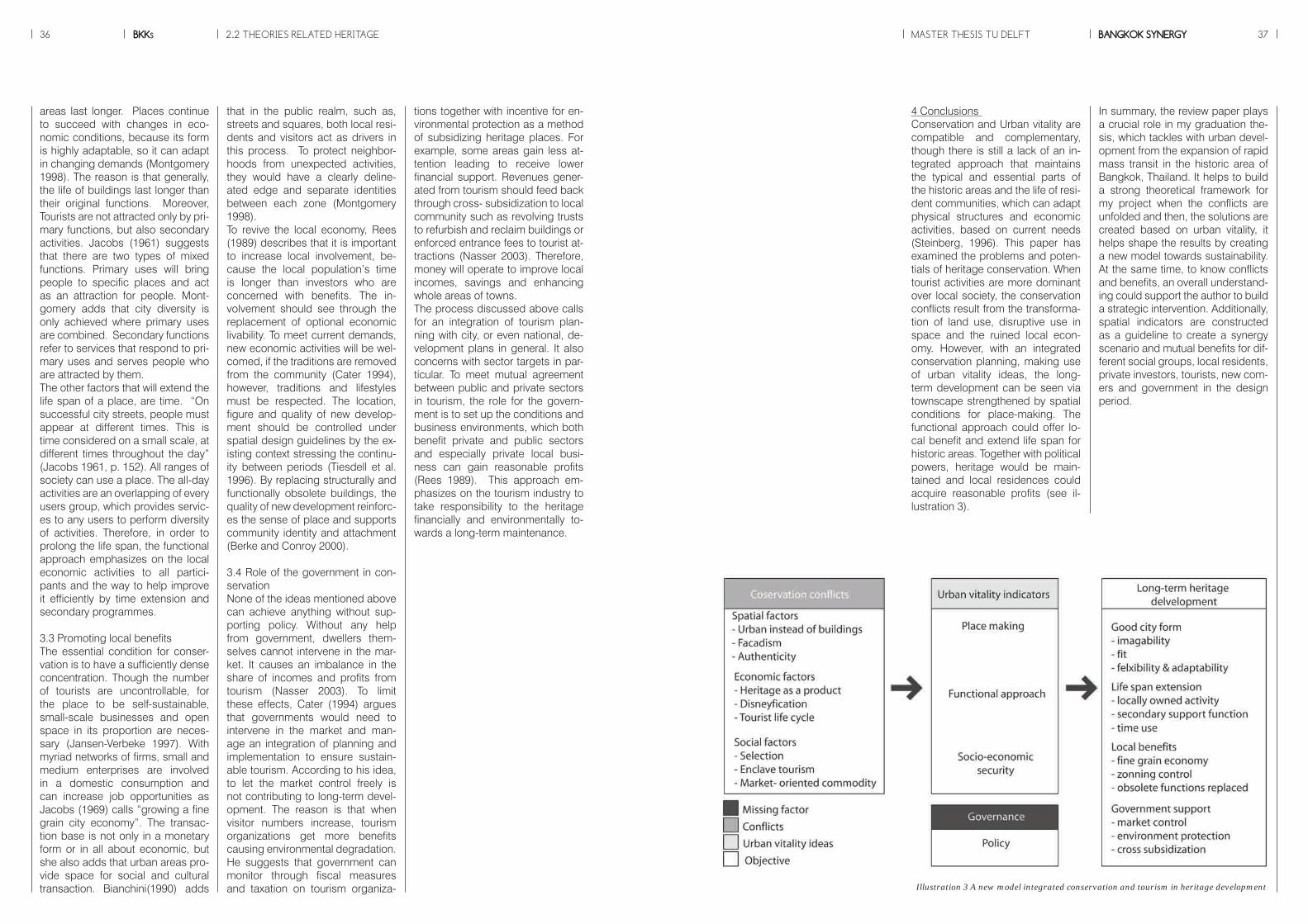
BKKs36 MASTER THESIS TU DELFT BANGKOK SYNERGY 37
In summary, the review paper plays a crucial role in my graduation the-sis, which tackles with urban devel-opment from the expansion of rapid mass transit in the historic area of Bangkok, Thailand. It helps to build a strong theoretical framework for my project when the conflicts are unfolded and then, the solutions are created based on urban vitality, it helps shape the results by creating a new model towards sustainability. At the same time, to know conflicts and benefits, an overall understand-ing could support the author to build a strategic intervention. Additionally, spatial indicators are constructed as a guideline to create a synergy scenario and mutual benefits for dif-ferent social groups, local residents, private investors, tourists, new com-ers and government in the design period.
4 Conclusions Conservation and Urban vitality are compatible and complementary, though there is still a lack of an in-tegrated approach that maintains the typical and essential parts of the historic areas and the life of resi-dent communities, which can adapt physical structures and economic activities, based on current needs (Steinberg, 1996). This paper has examined the problems and poten-tials of heritage conservation. When tourist activities are more dominant over local society, the conservation conflicts result from the transforma-tion of land use, disruptive use in space and the ruined local econ-omy. However, with an integrated conservation planning, making use of urban vitality ideas, the long-term development can be seen via townscape strengthened by spatial conditions for place-making. The functional approach could offer lo-cal benefit and extend life span for historic areas. Together with political powers, heritage would be main-tained and local residences could acquire reasonable profits (see il-lustration 3).
tions together with incentive for en-vironmental protection as a method of subsidizing heritage places. For example, some areas gain less at-tention leading to receive lower financial support. Revenues gener-ated from tourism should feed back through cross- subsidization to local community such as revolving trusts to refurbish and reclaim buildings or enforced entrance fees to tourist at-tractions (Nasser 2003). Therefore, money will operate to improve local incomes, savings and enhancing whole areas of towns. The process discussed above calls for an integration of tourism plan-ning with city, or even national, de-velopment plans in general. It also concerns with sector targets in par-ticular. To meet mutual agreement between public and private sectors in tourism, the role for the govern-ment is to set up the conditions and business environments, which both benefit private and public sectors and especially private local busi-ness can gain reasonable profits (Rees 1989). This approach em-phasizes on the tourism industry to take responsibility to the heritage financially and environmentally to-wards a long-term maintenance.
that in the public realm, such as, streets and squares, both local resi-dents and visitors act as drivers in this process. To protect neighbor-hoods from unexpected activities, they would have a clearly deline-ated edge and separate identities between each zone (Montgomery 1998). To revive the local economy, Rees (1989) describes that it is important to increase local involvement, be-cause the local population’s time is longer than investors who are concerned with benefits. The in-volvement should see through the replacement of optional economic livability. To meet current demands, new economic activities will be wel-comed, if the traditions are removed from the community (Cater 1994), however, traditions and lifestyles must be respected. The location, figure and quality of new develop-ment should be controlled under spatial design guidelines by the ex-isting context stressing the continu-ity between periods (Tiesdell et al. 1996). By replacing structurally and functionally obsolete buildings, the quality of new development reinforc-es the sense of place and supports community identity and attachment (Berke and Conroy 2000).
3.4 Role of the government in con-servationNone of the ideas mentioned above can achieve anything without sup-porting policy. Without any help from government, dwellers them-selves cannot intervene in the mar-ket. It causes an imbalance in the share of incomes and profits from tourism (Nasser 2003). To limit these effects, Cater (1994) argues that governments would need to intervene in the market and man-age an integration of planning and implementation to ensure sustain-able tourism. According to his idea, to let the market control freely is not contributing to long-term devel-opment. The reason is that when visitor numbers increase, tourism organizations get more benefits causing environmental degradation. He suggests that government can monitor through fiscal measures and taxation on tourism organiza-
areas last longer. Places continue to succeed with changes in eco-nomic conditions, because its form is highly adaptable, so it can adapt in changing demands (Montgomery 1998). The reason is that generally, the life of buildings last longer than their original functions. Moreover, Tourists are not attracted only by pri-mary functions, but also secondary activities. Jacobs (1961) suggests that there are two types of mixed functions. Primary uses will bring people to specific places and act as an attraction for people. Mont-gomery adds that city diversity is only achieved where primary uses are combined. Secondary functions refer to services that respond to pri-mary uses and serves people who are attracted by them. The other factors that will extend the life span of a place, are time. “On successful city streets, people must appear at different times. This is time considered on a small scale, at different times throughout the day” (Jacobs 1961, p. 152). All ranges of society can use a place. The all-day activities are an overlapping of every users group, which provides servic-es to any users to perform diversity of activities. Therefore, in order to prolong the life span, the functional approach emphasizes on the local economic activities to all partici-pants and the way to help improve it efficiently by time extension and secondary programmes.
3.3 Promoting local benefitsThe essential condition for conser-vation is to have a sufficiently dense concentration. Though the number of tourists are uncontrollable, for the place to be self-sustainable, small-scale businesses and open space in its proportion are neces-sary (Jansen-Verbeke 1997). With myriad networks of firms, small and medium enterprises are involved in a domestic consumption and can increase job opportunities as Jacobs (1969) calls “growing a fine grain city economy”. The transac-tion base is not only in a monetary form or in all about economic, but she also adds that urban areas pro-vide space for social and cultural transaction. Bianchini(1990) adds Illustration 3 A new model integrated conservation and tourism in heritage development
2.2 THEORIES RELATED HERITAGE
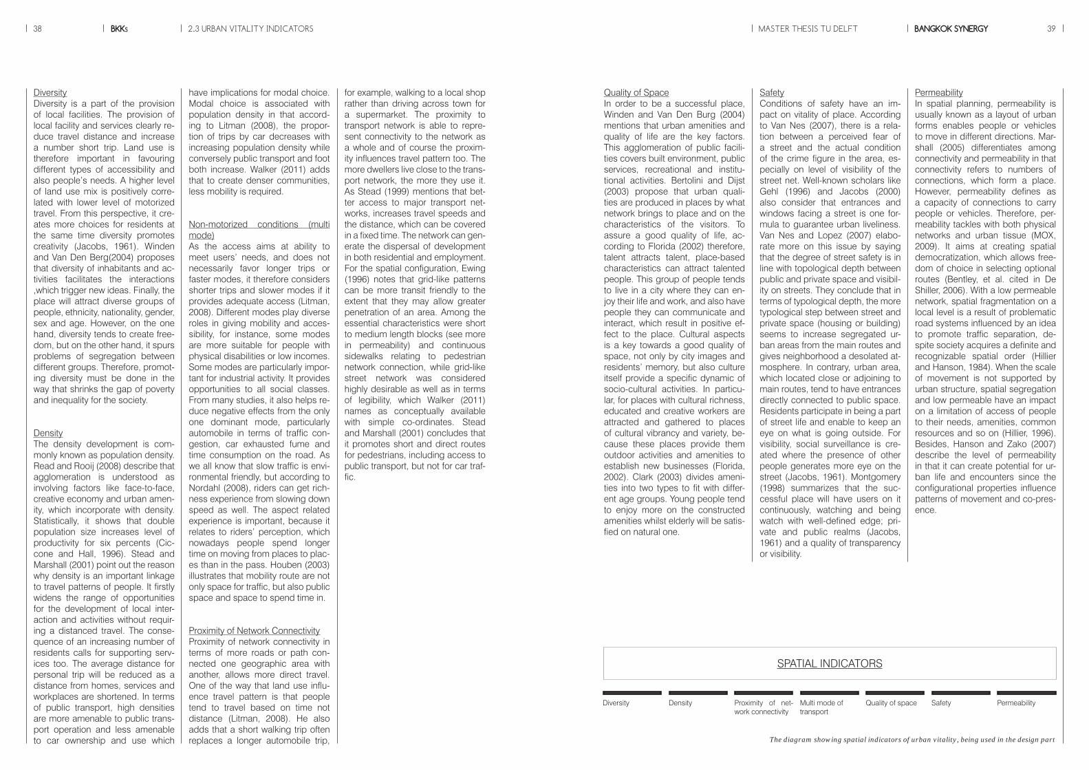
BKKs38 MASTER THESIS TU DELFT BANGKOK SYNERGY 39
PermeabilityIn spatial planning, permeability is usually known as a layout of urban forms enables people or vehicles to move in different directions. Mar-shall (2005) differentiates among connectivity and permeability in that connectivity refers to numbers of connections, which form a place. However, permeability defines as a capacity of connections to carry people or vehicles. Therefore, per-meability tackles with both physical networks and urban tissue (MOX, 2009). It aims at creating spatial democratization, which allows free-dom of choice in selecting optional routes (Bentley, et al. cited in De Shiller, 2006). With a low permeable network, spatial fragmentation on a local level is a result of problematic road systems influenced by an idea to promote traffic separation, de-spite society acquires a definite and recognizable spatial order (Hillier and Hanson, 1984). When the scale of movement is not supported by urban structure, spatial segregation and low permeable have an impact on a limitation of access of people to their needs, amenities, common resources and so on (Hillier, 1996). Besides, Hanson and Zako (2007) describe the level of permeability in that it can create potential for ur-ban life and encounters since the configurational properties influence patterns of movement and co-pres-ence.
SafetyConditions of safety have an im-pact on vitality of place. According to Van Nes (2007), there is a rela-tion between a perceived fear of a street and the actual condition of the crime figure in the area, es-pecially on level of visibility of the street net. Well-known scholars like Gehl (1996) and Jacobs (2000) also consider that entrances and windows facing a street is one for-mula to guarantee urban liveliness. Van Nes and Lopez (2007) elabo-rate more on this issue by saying that the degree of street safety is in line with topological depth between public and private space and visibil-ity on streets. They conclude that in terms of typological depth, the more typological step between street and private space (housing or building) seems to increase segregated ur-ban areas from the main routes and gives neighborhood a desolated at-mosphere. In contrary, urban area, which located close or adjoining to main routes, tend to have entrances directly connected to public space. Residents participate in being a part of street life and enable to keep an eye on what is going outside. For visibility, social surveillance is cre-ated where the presence of other people generates more eye on the street (Jacobs, 1961). Montgomery (1998) summarizes that the suc-cessful place will have users on it continuously, watching and being watch with well-defined edge; pri-vate and public realms (Jacobs, 1961) and a quality of transparency or visibility.
Quality of SpaceIn order to be a successful place, Winden and Van Den Burg (2004) mentions that urban amenities and quality of life are the key factors. This agglomeration of public facili-ties covers built environment, public services, recreational and institu-tional activities. Bertolini and Dijst (2003) propose that urban quali-ties are produced in places by what network brings to place and on the characteristics of the visitors. To assure a good quality of life, ac-cording to Florida (2002) therefore, talent attracts talent, place-based characteristics can attract talented people. This group of people tends to live in a city where they can en-joy their life and work, and also have people they can communicate and interact, which result in positive ef-fect to the place. Cultural aspects is a key towards a good quality of space, not only by city images and residents’ memory, but also culture itself provide a specific dynamic of socio-cultural activities. In particu-lar, for places with cultural richness, educated and creative workers are attracted and gathered to places of cultural vibrancy and variety, be-cause these places provide them outdoor activities and amenities to establish new businesses (Florida, 2002). Clark (2003) divides ameni-ties into two types to fit with differ-ent age groups. Young people tend to enjoy more on the constructed amenities whilst elderly will be satis-fied on natural one.
have implications for modal choice. Modal choice is associated with population density in that accord-ing to Litman (2008), the propor-tion of trips by car decreases with increasing population density while conversely public transport and foot both increase. Walker (2011) adds that to create denser communities, less mobility is required.
Non-motorized conditions (multi mode)As the access aims at ability to meet users’ needs, and does not necessarily favor longer trips or faster modes, it therefore considers shorter trips and slower modes if it provides adequate access (Litman, 2008). Different modes play diverse roles in giving mobility and acces-sibility, for instance, some modes are more suitable for people with physical disabilities or low incomes. Some modes are particularly impor-tant for industrial activity. It provides opportunities to all social classes. From many studies, it also helps re-duce negative effects from the only one dominant mode, particularly automobile in terms of traffic con-gestion, car exhausted fume and time consumption on the road. As we all know that slow traffic is envi-ronmental friendly, but according to Nordahl (2008), riders can get rich-ness experience from slowing down speed as well. The aspect related experience is important, because it relates to riders’ perception, which nowadays people spend longer time on moving from places to plac-es than in the pass. Houben (2003) illustrates that mobility route are not only space for traffic, but also public space and space to spend time in.
Proximity of Network Connectivity Proximity of network connectivity in terms of more roads or path con-nected one geographic area with another, allows more direct travel. One of the way that land use influ-ence travel pattern is that people tend to travel based on time not distance (Litman, 2008). He also adds that a short walking trip often replaces a longer automobile trip,
DiversityDiversity is a part of the provision of local facilities. The provision of local facility and services clearly re-duce travel distance and increase a number short trip. Land use is therefore important in favouring different types of accessibility and also people’s needs. A higher level of land use mix is positively corre-lated with lower level of motorized travel. From this perspective, it cre-ates more choices for residents at the same time diversity promotes creativity (Jacobs, 1961). Winden and Van Den Berg(2004) proposes that diversity of inhabitants and ac-tivities facilitates the interactions ,which trigger new ideas. Finally, the place will attract diverse groups of people, ethnicity, nationality, gender, sex and age. However, on the one hand, diversity tends to create free-dom, but on the other hand, it spurs problems of segregation between different groups. Therefore, promot-ing diversity must be done in the way that shrinks the gap of poverty and inequality for the society.
DensityThe density development is com-monly known as population density. Read and Rooij (2008) describe that agglomeration is understood as involving factors like face-to-face, creative economy and urban amen-ity, which incorporate with density. Statistically, it shows that double population size increases level of productivity for six percents (Cic-cone and Hall, 1996). Stead and Marshall (2001) point out the reason why density is an important linkage to travel patterns of people. It firstly widens the range of opportunities for the development of local inter-action and activities without requir-ing a distanced travel. The conse-quence of an increasing number of residents calls for supporting serv-ices too. The average distance for personal trip will be reduced as a distance from homes, services and workplaces are shortened. In terms of public transport, high densities are more amenable to public trans-port operation and less amenable to car ownership and use which
for example, walking to a local shop rather than driving across town for a supermarket. The proximity to transport network is able to repre-sent connectivity to the network as a whole and of course the proxim-ity influences travel pattern too. The more dwellers live close to the trans-port network, the more they use it. As Stead (1999) mentions that bet-ter access to major transport net-works, increases travel speeds and the distance, which can be covered in a fixed time. The network can gen-erate the dispersal of development in both residential and employment. For the spatial configuration, Ewing (1996) notes that grid-like patterns can be more transit friendly to the extent that they may allow greater penetration of an area. Among the essential characteristics were short to medium length blocks (see more in permeability) and continuous sidewalks relating to pedestrian network connection, while grid-like street network was considered highly desirable as well as in terms of legibility, which Walker (2011) names as conceptually available with simple co-ordinates. Stead and Marshall (2001) concludes that it promotes short and direct routes for pedestrians, including access to public transport, but not for car traf-fic.
2.3 URBAN VITALITY INDICATORS
SPATIAL INDICATORS
Safety PermeabilityQuality of spaceMulti mode of transport
Diversity Density Proximity of net-work connectivity
The diagram showing spatial indicators of urban vitality, being used in the design part
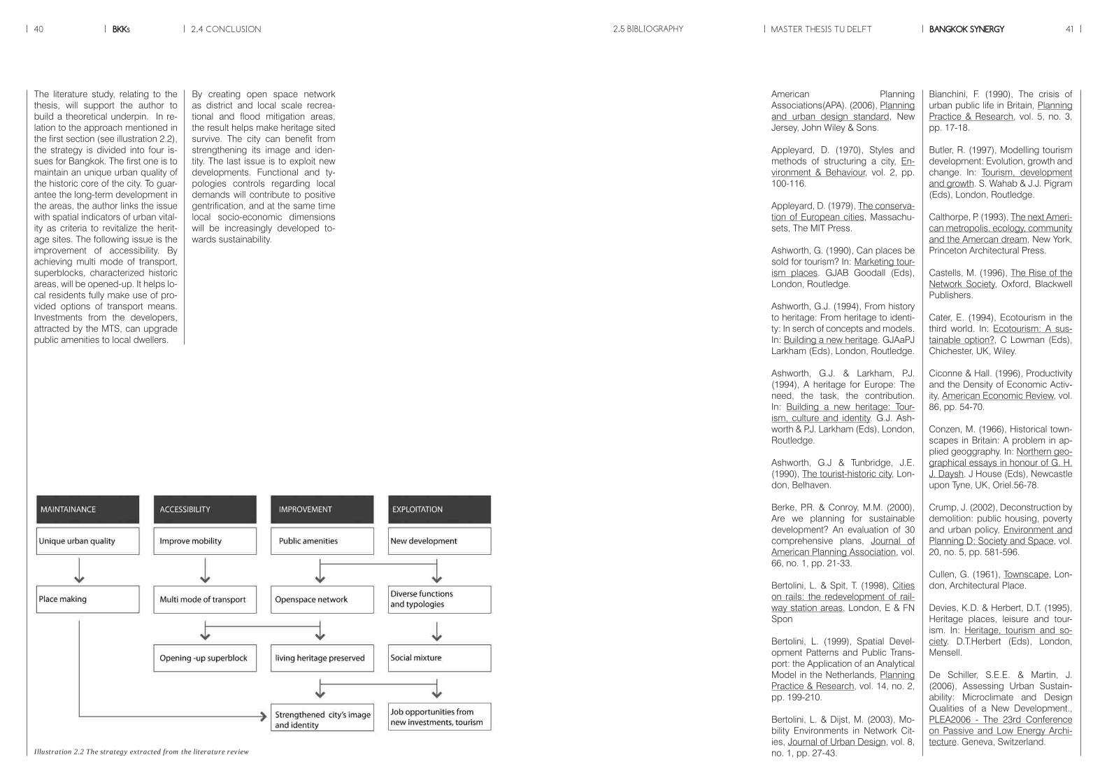
BKKs40 MASTER THESIS TU DELFT BANGKOK SYNERGY 41
Bianchini, F. (1990), The crisis of urban public life in Britain, Planning Practice & Research, vol. 5, no. 3, pp. 17-18.
Butler, R. (1997), Modelling tourism development: Evolution, growth and change. In: Tourism, development and growth. S. Wahab & J.J. Pigram (Eds), London, Routledge.
Calthorpe, P. (1993), The next Ameri-can metropolis. ecology, community and the Amercan dream, New York, Princeton Architectural Press.
Castells, M. (1996), The Rise of the Network Society, Oxford, Blackwell Publishers.
Cater, E. (1994), Ecotourism in the third world. In: Ecotourism: A sus-tainable option?, C Lowman (Eds), Chichester, UK, Wiley.
Ciconne & Hall. (1996), Productivity and the Density of Economic Activ-ity, American Economic Review, vol. 86, pp. 54-70.
Conzen, M. (1966), Historical town-scapes in Britain: A problem in ap-plied geoggraphy. In: Northern geo-graphical essays in honour of G. H. J. Daysh. J House (Eds), Newcastle upon Tyne, UK, Oriel.56-78.
Crump, J. (2002), Deconstruction by demolition: public housing, poverty and urban policy, Environment and Planning D: Society and Space, vol. 20, no. 5, pp. 581-596.
Cullen, G. (1961), Townscape, Lon-don, Architectural Place.
Devies, K.D. & Herbert, D.T. (1995), Heritage places, leisure and tour-ism. In: Heritage, tourism and so-ciety. D.T.Herbert (Eds), London, Mensell.
De Schiller, S.E.E. & Martin, J. (2006), Assessing Urban Sustain-ability: Microclimate and Design Qualities of a New Development., PLEA2006 - The 23rd Conference on Passive and Low Energy Archi-tecture. Geneva, Switzerland.
American Planning Associations(APA). (2006), Planning and urban design standard, New Jersey, John Wiley & Sons.
Appleyard, D. (1970), Styles and methods of structuring a city, En-vironment & Behaviour, vol. 2, pp. 100-116.
Appleyard, D. (1979), The conserva-tion of European cities, Massachu-sets, The MIT Press.
Ashworth, G. (1990), Can places be sold for tourism? In: Marketing tour-ism places. GJAB Goodall (Eds), London, Routledge.
Ashworth, G.J. (1994), From history to heritage: From heritage to identi-ty: In serch of concepts and models. In: Building a new heritage. GJAaPJ Larkham (Eds), London, Routledge.
Ashworth, G.J. & Larkham, P.J. (1994), A heritage for Europe: The need, the task, the contribution. In: Building a new heritage: Tour-ism, culture and identity. G.J. Ash-worth & P.J. Larkham (Eds), London, Routledge.
Ashworth, G.J & Tunbridge, J.E. (1990), The tourist-historic city, Lon-don, Belhaven.
Berke, P.R. & Conroy, M.M. (2000), Are we planning for sustainable development? An evaluation of 30 comprehensive plans, Journal of American Planning Association, vol. 66, no. 1, pp. 21-33.
Bertolini, L. & Spit, T. (1998), Cities on rails: the redevelopment of rail-way station areas, London, E & FN Spon
Bertolini, L. (1999), Spatial Devel-opment Patterns and Public Trans-port: the Application of an Analytical Model in the Netherlands, Planning Practice & Research, vol. 14, no. 2, pp. 199-210.
Bertolini, L. & Dijst, M. (2003), Mo-bility Environments in Network Cit-ies, Journal of Urban Design, vol. 8, no. 1, pp. 27-43.
By creating open space network as district and local scale recrea-tional and flood mitigation areas, the result helps make heritage sited survive. The city can benefit from strengthening its image and iden-tity. The last issue is to exploit new developments. Functional and ty-pologies controls regarding local demands will contribute to positive gentrification, and at the same time local socio-economic dimensions will be increasingly developed to-wards sustainability.
2.4 CONCLUSION
Illustration 2.2 The strategy extracted from the literature review
The literature study, relating to the thesis, will support the author to build a theoretical underpin. In re-lation to the approach mentioned in the first section (see illustration 2.2), the strategy is divided into four is-sues for Bangkok. The first one is to maintain an unique urban quality of the historic core of the city. To guar-antee the long-term development in the areas, the author links the issue with spatial indicators of urban vital-ity as criteria to revitalize the herit-age sites. The following issue is the improvement of accessibility. By achieving multi mode of transport, superblocks, characterized historic areas, will be opened-up. It helps lo-cal residents fully make use of pro-vided options of transport means. Investments from the developers, attracted by the MTS, can upgrade public amenities to local dwellers.
2.5 BIBLIOGRAPHY

BKKs42 MASTER THESIS TU DELFT BANGKOK SYNERGY 43
Read, S & Rooij, R. (2008), Integrat-ing Mobility Environments in the City, REAL CORP 008 Proceedings / Tagungsband. Vienna, May 19-21 2008 www.corp.at.
Rees, W.E., (1989), Defining sus-tainable development. Center for Human Settlements research bul-letin. Vancouver, Canada: Center for Human Settlements, University of British Columbia.
Salingaros, N. (2005), Principles of Urban Structure. Design/Sci-ence/Planning Series, Amsterdam, Techne Press.
Simpson, B.J. (1994), Urban pub-lic transport today, London, E&FN Spon.
Smith, N. (2002), New globalism, new urbanism: Gentrificatin as a global urban strategy. In: Spaces of neoliberalism: Urban restruct-ing in North Amercan and Western Europe. N Brenner & N Theodore (Eds), Oxford, Blackwell Publishers.
Spencer, C. & Dixon, J. (1983), Map-ping the development of feelings about the city, Transactions of the Institute of British Geographers, vol. 8, pp. 373-383.
Stead, D. (1999), Planning for less travel – identifying land use char-acteristics associated with more sustainable travel patterns., Unpub-lished PhD Thesis, Bartlett School of Planning, University College Lon-don, London.
Stead, D. & Marshall, S. (2001), The Relationship between Urban form and Travel Patterns. An International review and Evaluation, EJTIR, vol. 1, no. 2, pp. 113-141.
Steinberg, F. (1996), Conservation and rehabilitation of urban herit-age in developing countries, Habitat INTL., vol. 20, no. 3, pp. 463-475.
Sternberg, E. (2000), An integrative theory of urban design, Journal of American Planning, vol. 6, no. 3, pp. 265-278.
Tiesdell, S. (1996), Revitalizing his-toric urban quarters, London, But-terworth-Heinemann.
Urry, J. (1990), The tourist gaze: Leisure and travel in contemporary societies, London, Sage.
Walker, J. (2011), Human Transit: How Clearer Thinking About Public Transit Can Enrich Our Communi-ties and Our Lives, Island Press.
Winden, W.V. & Berg, L.Van Den. (2004), Cities in the Knowledge Economy: New Governance Chal-lenges, Rotterdam: Discussion Pa-per Euricur.
Worskett, R. (1969), The character of towns- An approach to servation, London, Architectural Press.
Jacobs, M. (2000), Multinodal Ur-ban Structures : A Comparative Analysis and Strategies for Design, Delft, Delft University Press.
Jansen-Verbeke, M. (1997), Sustain-ability and planning: Diverse con-cepts and close associations. In: Tourism, development and growth. S.Wahab J.J.Pigram (Eds), London, Routledge.
Jepson, E.J. (2001), Sustainabil-ity and planning: Diverse concepts and close associations., Journal of Planning Literature, vol. 15, no. 4, pp. 499-510
Jokilehto, J. (1999), A history of ar-chitectural conservation, Oxford,UK, Butterworth-Heinemann.
Karpati, T.H. (2008), Management of World Heritage Sites, VDM Verlag.
Larkham, P.J (1990), Conservation and the management of histori-cal townscapes. In: The built form of Western cities. T.R. Slater (Eds), Leicester, UK, Leicester University Press.
Larkham, P.J (1995), Heritage as planned and consserved. In: Heritage, tourism and society. D.T.Herbert (Eds), London, Mansell.
Larkham, P.J. (1996), Conservation and the city, London, Routledge.
Litman, T. (2011), Measuring Trans-portation, ITE Journal, vol. 73, no. 10, pp. 28-32.
Lynch, K. (1960), The image of the city, Cambridge, MA, MIT press.
Lynch, K. (1981), A theory of good city form, Cambridge,MA, MIT Press.
Marshall, S. (2005), Streets and Pat-terns, London, Spon.
Montgomery, J. (1998), Making a city: Urbanity, Vitality and Urban De-sign, Journal of Urban Design, vol. 3, no. 1, pp. 93-116.
Hamnett, C. (1991), The blind men and the elephant: the explanation of gentrification, Transactions of the Institute of British Geographers, vol. 16, no. 2, pp. 173-189.
Hanson, J. & Zako, R. (2007), Comunities of Copresence and Sur-veillance: How Public Open Space Shapes Awareness and Behaviour in Residential Developments., Pro-ceedings of the Sixth International Space Syntax Symposium, Istanbul.
Harvey, D. (2006), Space as a Key Word. In: Harvey, Spaces of Global Capitalism.(Eds), London Verso.
Healy, R. (1992), ‘The role of tour-ism in sustainable development’, the IVth World Parks Congress on National Parks and Protected Areas.
Hillier, B. (1996), Space is the Ma-chine, Cambridge, Cambridge Uni-versity Press.
Hillier, B. & Hanson, J. (1984), The Social Logic of Space, Cambridge, Cambridge University Press.
Houben, F. (2003), Mobility, A Room with a View, Rotterdam, NAi Publish-ers.
Hubbard, P. (1993), The value of conservation: A critical review of be-havioural research, Town Planning Review, vol. 64, no. 4, pp. 359-373.
ITE Smart Growth Task Force. (2003), Smart Growth Transporta-tion Guidelines., Institute of Trans-portation Engineers.
Jacobs, J. (1961), The death and life of great American cities, London, Vintage Books.
Jacobs, K. (1969), The economy of cities, London, Edware Arnold.
Jacobs, M. (1991), The green econ-omy: Environment, sustainable de-velopment, and the politics of the future, Concord,MA, Pluto.
MOX. (2009), Methematical Models in Urban Design, Milano, Politecnico di Milano.
Nagy, Z. (2010), Glove Actually: Inte-gration and Gentrification in a com-munity center in Budapest, Central European University.
Nasser, N. (2003), Planning for ur-ban heritage places: Reconciling Conservation, Tourism and Sustain-able Development, Journal of Plan-ning Literature, vol. 17, no. 4, pp. 467-479.
Nes, A.Van & Lopez, M.J.J. (2007), Micro Scale spatial Relationships in Urban Studies: The Relationship Between Private and Public Space and Its Impact on Street Life, Pro-ceedings, 6th International Space Syntax Symposium, İstanbul.
Newby, P. (1994), Tourism-Support or threat to heritage. In: Building a new heritage: Tourism, culture and identity. G.J.Ashworth & P.J. Larkham (Eds), London, Routledge.
Norberg-Schulz, C. (1985), The Concept of Dwelling, New York, Riz-zoli.
Nordahl, D. (2008), My Kind of Tran-sit: Rethinking Public Transportation in America., Center for American Places.
Oncu, A. & Weyland, P. (1997), Struggles over Lebenstraum and social identities in globalising cities. In: Space, culture and power: New identities in globalising cities. PW A. Oncu (Eds), London, Zed Books.
Orbasli, A. (2000), Tourists in histor-ic towns: Urban conservation and heritage management, London and New York, E & FN Spon.
Read, S. (2001), Neighbourhood Spatial Processes: Notes on Pub-lic Space, ‘Thick’ Space, Scale and Centrality, Faculty of Architecture, Delft University of Technology.
Dupuy, G. (1991), L’Urbanisme des Reseaux. Theories et Methodes, Paris, Armand Colin.
English Nature (1992), Strategic planning and sustainable develop-ment. Consultation paper. David Tyldesley Associaties on behalf of English Nature, Peterborough, UK.
Ewing, R. (1996), Pedestrian- and Transit-Friendly Design. Report pre-pared for the Public Transit Office, Florida Department of Transporta-tion.
Feilden, B.M. (2003), Conservation of historic buildings, Architectural Press.
Fitch, J.M. (1982), Historic preserva-tion: Curatorial management of the built world, New York, McGraw-Hill.
Florida, R. (2002), The rise of the creative class. And How It’s Trans-forming Work, Leisure, Community and Everyday Life, New York, Basic Books.
Furze, B, Lacy, T.D. & Birckhead, J. (1996), Culture, conservation, and biodiversity: the social dimension of linking local level development and conservation through protected ar-eas, John Wiley.
Gehl, J. (1996), Life between Build-ings: Using Public Space (2nd ed), Copenhagen, The Danish Architec-tureal Press.
Golledge, R (1977), Learning about urban environments. In: Timing Space and Spacing Time. P.T. Carl-stein (Eds), London, Edward Arnold.
Graham, S & Marvin, S. (1996), Telecommunications and the City. Electronic Spaces, Urban Spaces, London, Routledge.
Graham, S & Marvin, S. (2001), Splinter Urbanism, London and New York, Routledge.
2.5 BIBLIOGRAPHY
BKKs44
Source : www.skyscrapercity.com
45BANGKOK SYNERGYMASTER THESIS TU DELFT
Chapter 3CONTEXT RESEARCH AND ANALYSIS
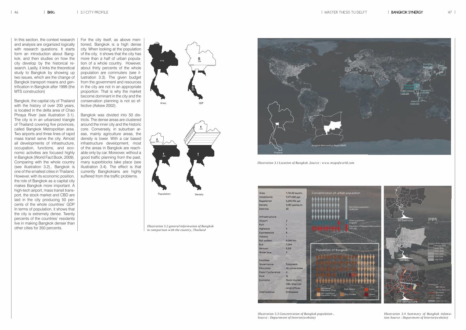
BKKs46 MASTER THESIS TU DELFT BANGKOK SYNERGY 47
20%BMA:72%BMR:28%
80%
50%
50%
BMA:80%BMR:20%
0.3%
99.7%
1%
350%
Area GDP Population Density
20%BMA:72%BMR:28%
80%
50%
50%
BMA:80%BMR:20%
0.3%
99.7%
1%
350%
Area GDP Population Density
3.1 CITY PROFILE
Shanghai13,447,000
Jakarta8,500,000
Singapore5,000,000
Kuala lumpur7,300,000
Tokyo12,790,000
Bangkok Metropolitan Region[BMR]
Thailand
Bangkok10,161,694
Illustration 3.1 Location of Bangkok ,Source : www.mapofworld.com
Population of Bangkok
Registered Population (Thai)
Non-registered Population (Thai) Thai-Chinese
East-Asians Indian
Others
Urban population : 19,361,000
Non-Urban population : 42,802,000
Population of Bangkok Metropolitan : 11,971,000
Concentration of urban population
5,000 - 10,000
10,000 - 15,000
15,000 - 20,000
20,000 - 25,000
25,000 - 30,000
More than 30,000
Population Density (person/sq.m.)
Toll way (Motor way)
Expressway
Ring road
Metro
Airport link rail
Main Highway
Infrastuctures
50 Districts
Density
Infrastructure
0 km. 10 km.
Area 7,761.50 sq.km.
Inhabitants 11,971,000 ppl
Registered 5,695,956 ppl
Density 4,051 ppl/sq.m.
Districts 50
Infrastructure
Airport 2
Port 1
Highways 6
Expressways 8
Subway 1
Rail system 4,346 km.
Bus 7,064
Minivan 5,519
Water bus 9
Facilities
Governance Paliament
Education 45 universities
Expo/ Conference 4
Park 16
Economic Stock market,
CBD, internat-
ional offices
International Embassies
Illustration 3.3 Concentration of Bangkok population ,Source : Department of Interior(website)
Illustration 3.4 Summary of Bangkok infoma-tion Source : Department of Interior(website)
Illustration 3.2 general information of Bangkok in comparison with the country, Thailand
In this section, the context research and analysis are organized logically with research questions. It starts form an introduction about Bang-kok, and then studies on how the city develop by the historical re-search. Lastly, it links the theoretical study to Bangkok by showing up two issues, which are the change of Bangkok transport means and gen-trification in Bangkok after 1999 (the MTS construction)
Bangkok, the capital city of Thailand with the history of over 200 years, is located in the delta area of Chao Phraya River (see illustration 3.1). The city is in an urbanized triangle of Thailand covering five provinces, called Bangkok Metropolitan area. Two airports and three lines of rapid mass transit serve the city. Almost all developments of infrastructure, occupation, functions, and eco-nomic activities are focused highly in Bangkok (World Fact Book, 2009). Comparing with the whole country (see illustration 3.2)., Bangkok is one of the smallest cities in Thailand. However, with its economic position, the role of Bangkok as a capital city makes Bangkok more important. A high-tech airport, mass transit trans-port, the stock market and CBD are laid in the city producing 50 per-cents of the whole countries’ GDP. In terms of population, it shows that the city is extremely dense. Twenty percents of the countries’ residents live in making Bangkok denser than other cities for 350 percents.
For the city itself, as above men-tioned, Bangkok is a high dense city. When looking at the population of the city, it shows that the city has more than a half of urban popula-tion of a whole country. However, about thirty percents of the whole population are commuters (see il-lustration 3.3). The given budget from the government and resources in the city are not in an appropriate proportion. That is why the market become dominant in the city and the conservation planning is not so ef-fective (Askew 2002).
Bangkok was divided into 50 dis-tricts. The dense areas are clustered around the inner city and the historic core. Conversely, in suburban ar-eas, mainly agriculture areas, the density is lower. With a car based infrastructure development, most of the areas in Bangkok are reach-able only by car. Moreover, without a good traffic planning from the past, many superblocks take place (see illustration 3.4). The effect is that currently Bangkokians are highly suffered from the traffic problems.

BKKs48 MASTER THESIS TU DELFT BANGKOK SYNERGY 49
Portraits of the cityThe photos of the current condition of Bangkok are selected not only to give an impression about the city, but also to elaborate the top-ics more practically. Together with the pictures, the current condition of MTS is always built on top of the road. The elevated rail system usu-ally, plug in to the prestigious func-tions, such as high-class hotels and luxurious huge department stores (Mcgrath 2009). He adds that the lower level, in where more dynam-ic functions located with informal economic sectors- street vendors and food stalls, is left to bad condi-tions by the very congested traffic. However, city has many high-valued
heritage items, in a form not only places or temples, but also unique opened-air local market, which draw big attentions from tourism indus-tries generating big money flows to the city. However, the condition of the historic places, when the mass transit comes, it still uncertain.
Bangkok’s government visionBangkok is a monocentric city. From the regional level, it was designated as the first city surrounded by sec-ond and third cities respectively. With its high economic position, every logistic route passes Bang-kok (see illustration 3.5 ). It acts as a stepping stone connecting north to south and east to west. In the city
2030 vision (see illustration 3.6), the government has defined a new eco-nomic ring surrounded the central business district (CBD) of the city, and together with a plan for mass transit expansion, which will finish in 2030(see illustration 3.7). as well. Along with the vision, it gives us a big chance to think about how to balance the long-time spontaneous development with the new mass transit expansion. The connection between each area, which recently connects by private vehicles, needs to be re-established and the spatial development needs to be re-con-sidered as well as the role of the ar-eas need to be re-identified.
1. Siam paragon2. Khaosan road3. Traffic congestion4. The grand palace5. Jatujak outdoor market6. Food vendors and motorcy-cle taxi7. Skyline8. Suvarnabhumi airport9. Bangkok rapid mass transit system
City images , Source : www.flickr.com
1 2
8
65
9
3City icons
S
E
W
N
S
E
W
N
S
E
W
N
S
E
W
N
S
E
W
N
S
E
W
N
S
E
W
N
CBD
Commercial center
Community center
S
E
W
N
S
E
W
N
S
E
W
N
First city
Second city
Third city
Illustration 3.6 The MTS of Bangkok in 2030 in comparison with the current con-dition, Source : Bangkok planning stand-ard(2010)
Illustration 3.5 Bangkok from the national vision, Source : Bangkok planning stand-ard(2010)
3.1 CITY PROFILE
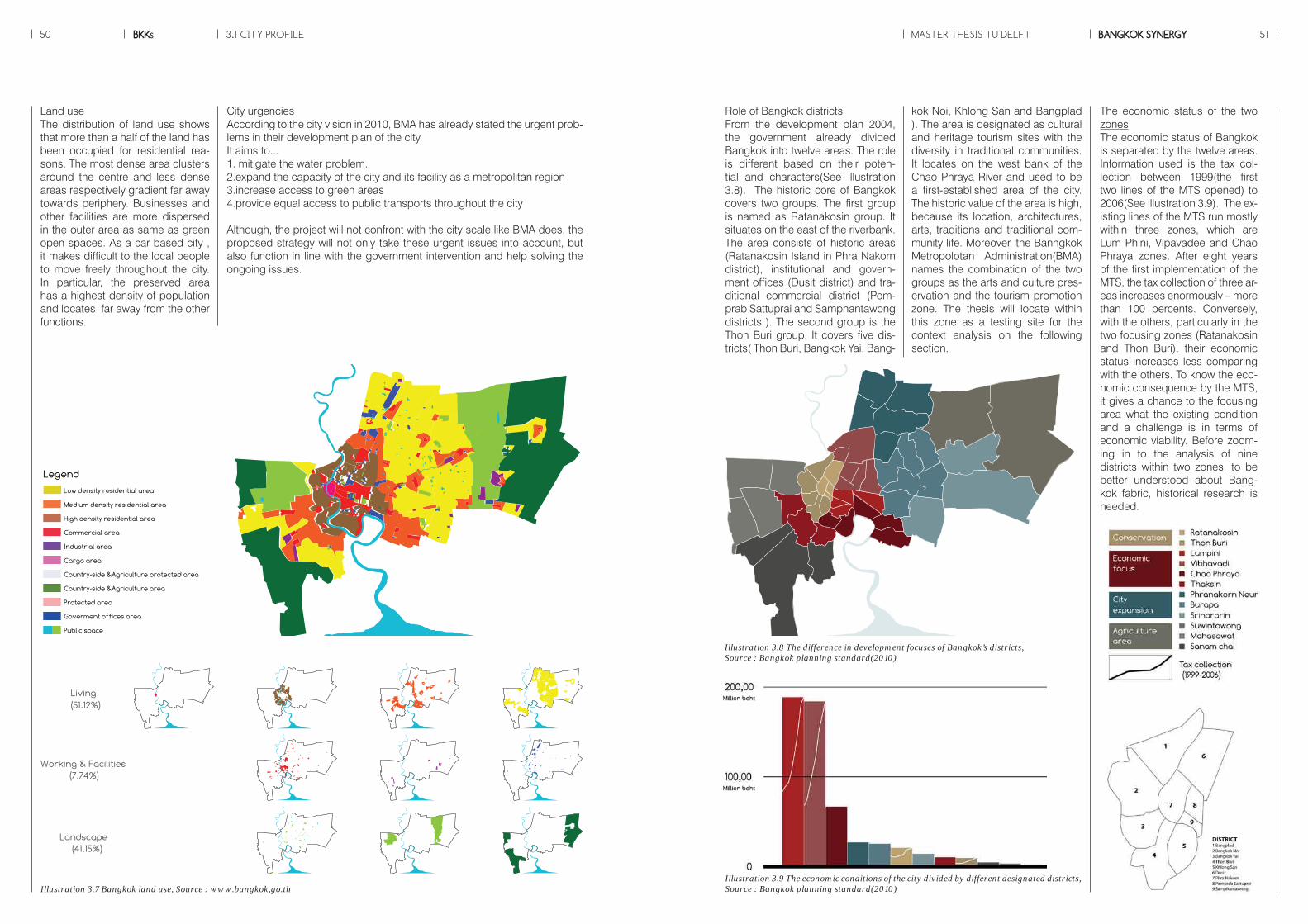
BKKs50 MASTER THESIS TU DELFT BANGKOK SYNERGY 51
City urgenciesAccording to the city vision in 2010, BMA has already stated the urgent prob-lems in their development plan of the city. It aims to...1. mitigate the water problem.2.expand the capacity of the city and its facility as a metropolitan region3.increase access to green areas4.provide equal access to public transports throughout the city
Although, the project will not confront with the city scale like BMA does, the proposed strategy will not only take these urgent issues into account, but also function in line with the government intervention and help solving the ongoing issues.
Land useThe distribution of land use shows that more than a half of the land has been occupied for residential rea-sons. The most dense area clusters around the centre and less dense areas respectively gradient far away towards periphery. Businesses and other facilities are more dispersed in the outer area as same as green open spaces. As a car based city , it makes difficult to the local people to move freely throughout the city. In particular, the preserved area has a highest density of population and locates far away from the other functions.
Illustration 3.7 Bangkok land use, Source : www.bangkok,go.th
Low density residential area
Medium density residential area
High density residential area
Commercial area
Industrial area
Cargo area
Country-side &Agriculture protected area
Country-side &Agriculture area
Protected area
Goverment offices area
Public space
LegendLiving
Landscape
Working & Facilities(7.74%)
(41.15%)
(51.12%)
40x20 km.
The economic status of the two zonesThe economic status of Bangkok is separated by the twelve areas. Information used is the tax col-lection between 1999(the first two lines of the MTS opened) to 2006(See illustration 3.9). The ex-isting lines of the MTS run mostly within three zones, which are Lum Phini, Vipavadee and Chao Phraya zones. After eight years of the first implementation of the MTS, the tax collection of three ar-eas increases enormously – more than 100 percents. Conversely, with the others, particularly in the two focusing zones (Ratanakosin and Thon Buri), their economic status increases less comparing with the others. To know the eco-nomic consequence by the MTS, it gives a chance to the focusing area what the existing condition and a challenge is in terms of economic viability. Before zoom-ing in to the analysis of nine districts within two zones, to be better understood about Bang-kok fabric, historical research is needed.
Role of Bangkok districtsFrom the development plan 2004, the government already divided Bangkok into twelve areas. The role is different based on their poten-tial and characters(See illustration 3.8). The historic core of Bangkok covers two groups. The first group is named as Ratanakosin group. It situates on the east of the riverbank. The area consists of historic areas (Ratanakosin Island in Phra Nakorn district), institutional and govern-ment offices (Dusit district) and tra-ditional commercial district (Pom-prab Sattuprai and Samphantawong districts ). The second group is the Thon Buri group. It covers five dis-tricts( Thon Buri, Bangkok Yai, Bang-
kok Noi, Khlong San and Bangplad ). The area is designated as cultural and heritage tourism sites with the diversity in traditional communities. It locates on the west bank of the Chao Phraya River and used to be a first-established area of the city. The historic value of the area is high, because its location, architectures, arts, traditions and traditional com-munity life. Moreover, the Banngkok Metropolotan Administration(BMA) names the combination of the two groups as the arts and culture pres-ervation and the tourism promotion zone. The thesis will locate within this zone as a testing site for the context analysis on the following section.
Illustration 3.9 The economic conditions of the city divided by different designated districts, Source : Bangkok planning standard(2010)
RatanakosinThon BuriLumpiniVibhavadi Chao PhrayaThaksinPhranakorn NeurBurapa SrinararinSuwintawongMahasawatSanam chai
Agriculturearea
City expansion
Economicfocus
Conservation
Illustration 3.8 The difference in development focuses of Bangkok’s districts,Source : Bangkok planning standard(2010)
3.1 CITY PROFILE

BKKs52 MASTER THESIS TU DELFT BANGKOK SYNERGY 533.2 HISTORIC DEVELOPMENT
Illustration 3.10 Bangkok in the first period, Source: Committee for the Conservation and Development of Krung Rattanakosin and The Old Towns, 2004
1.Establishment of original Bang-kok(1782-1852)Before establishing a new capital, King Rama I determined to plan and rebuild the new capital city as close as possible to the Ayutthaya proto-type, the former capital city (Warren, 2002). Canals were enlarged on the east side to link with the main river, Chao Phraya River, making city sur-rounded by water. It was called Ra-tanakosin Island nowadays. The city was built with hierarchical order. In other words, inner areas were highly important (see illustration 3.10). Within the wall, the Grand Palace represented the highest order sur-rounded by temples. The temples for Thai society were everything, for example, they function as public school, library, hospital, garden and
community centre. The city was for-tified by wall and river, which was as not only a defensive component, but also a main mode of transportation. Canals network indicated the pat-tern of urban development in early Bangkok. Based on its location as a port city, Bangkok continued its role as a successful trading city of the east. In this period, a number of new canals were dug and widened while many existing canals were deepened to facilitate shipping (Yantrasast, 1995). Although most urban development activities were carried out through the King’s vision and aspiration, existing physical condition, politics and socio-culture seemed to play significant roles in defining the urban space (ibid).
In order to understand the mecha-nisms and anticipate effects, the historic analysis aims at seeking for the relationship between infra-structure developments and the city growth from the past. The trans-formation of urban space and pat-terns of development are studied. It unfolds the history of the city from the origins and driving forces trig-gering changes. In this analysis, the history is divided into five significant periods.
Built-up area Water
of civilisation and progress (Askew, 2002). Lot of projects concerning modernization were elected such as road construction and infrastructure improvement (see illustration 3.11). Thailand preserved the formal sov-ereignty of its monarchs together with the realm’s hierarchical struc-ture (Askew, 2002). With these two strategies, many roads were built to facilitate commercial expansion par-alleling with the Chao Phraya River. It routed to commercial districts and foreign consulates whose land was royally granted to establish foreign relations (Office of Natural Resourc-es and Environmental Policy and Planning, 2004). Bangkok became land-based settlement. The build-ing of shop houses and markets along new roads adjusted vastly the
urban scene (see illustration 3.12). However, the indigenous structure remained. Five temples were built and more than twenty were restored. Heritage started to draw attention from the rulers in this period. King Rama IV used modern technolo-gies to renovate heritage from King Rama II.
2. 1st Modernization wave(1852-1885)Western people influenced the ur-ban development in this period. The two main significant events transformed the city in both social and physical terms. First, Thailand signed the Bowring Treaty with UK. It led a dramatic change in the socio-economic process of the country. The contract allowed the westerns to engage in the local socio-economic structure (Yantrasast, 1995). The city expansion served for trading and business demands. Besides, more and more Westerners started settling in the city that created a big impact to Thai society. For the sec-ond reason, the strategy to avoid the threat of colonisation was to present the country with a spectacle
Built-up area Water Road
Illustration 3.12 Picture showing the Western influence in the De-velopment and Modernity of Bangkok, Source: Yantrasart 1995
Illustration 3.11 Bangkok in the second period, mainly focusing on the infrastructure expansion, Source: Yantrasart 1995

BKKs54 MASTER THESIS TU DELFT BANGKOK SYNERGY 55
Illustration 3.13 Lumphini Park; the biggest public park of Bang-kok, Source: www.flickr.com
stead of expanding the urban area, most of the sixth King’s works paid more attention to the addition of amenities in order to modernize city. For instance, hospitals, universities and public Park were created. Es-pecially, the first and biggest public park in Bangkok, Lumpini Park, be-came the most important of his work and still being used nowadays (see illustration 3.13). Not only had he produced spatial configurations, but he also did a change in reformation of land law . Though Bangkok had continued to change, it occurred with slower pace during this period. Because of the reformation of the land law, there was an increase in the involvement of private landown-ers and developers within urban de-velopment.
NOTEBased on the ancient laws, the King was officially the owner of all the lands. With the shift in economy af-ter the Bowring Treaty and the canal excavation, there was a reformation of the land law. In order to encour-age the canal excavation company to engage in land development, the land title was systematically es-tablished to end the disagreement over landholding and profit (Askew, 2002).
3. City expansion by the transporta-tion revolution(1886-1934)As same as King Rama IV’s period, shop houses were a main function to stimulate economic activities. With this development, commercial communities provided places for lo-cal people to live and job opportu-nities too. To relate to a strong will to modernize the city, beautification was set as a main concept to shape Bangkok. It was a big change in this period that visual aesthetic of the city’s physical appearance had ma-terialized in planning issues (Askew 2002). Additionally, the development of Bangkok reflected the urban de-sign concept, which was the city in the park. King Rama VI took the pol-icy from his predecessors. He start-ed to build more roads and bridges. Unlike the two previous Kings, in-
Built-up area Water Road Train
4. Road network development (1935-1959)The Second World War played im-portant role in development of ur-ban structure in this period. Popula-tion grew rapidly, and a number of urban migrations and the political power changed towards democracy in 1932. Unsurprisingly, it triggered a new urban phenomenon. With ending of the absolute monarchy, military government was appointed as a new leader (Yahtrasast, 1995). To response to a large amount of population, this period infrastruc-ture drew a main attention. Bangkok was still building road network and bridges that connected to the other side of the river, one-fifth of city’s population relocated. As a chain re-action, the governance system was divided into two administrative mu-
nicipalities, east and west side. This system let them participate more in local government (Askew,2002). Ac-cording to Askew (1994) while the monuments and architecture of the fort city of Rattanakosin were histori-cized through monument preserva-tion legislation, many royal palaces and royal residences were modified to become government offices. With their new function, these buildings resulted in land use change (see il-lustration 3.14).
Built-up area Water Road Train
Illustration 3.14 The change in built-up areas, Source: Beek 1999
3.2 HISTORIC DEVELOPMENT
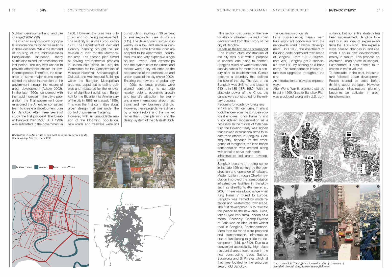
BKKs56 MASTER THESIS TU DELFT BANGKOK SYNERGY 573.3 INFRASTRUCTURE DEVELOPMENT
Illustration 3.15 An origin of compact buildings to serve popula-tion booming, Source: Beek 1999
1960. However, the plan was criti-cized and not being implemented. The next city’s plan was produced in 1971. The Department of Town and Country Planning brought the first revision of Plan for the Metropoli-tan area. The second plan aimed at solving environmental problem in Ratanakosin Island. In 1976, the Committee for the Conservation of Valuable Historical, Archaeological, Cultural, and Architectural Buildings within the Bangkok Metropolitan area was appointed to define poli-cies and measures for the renova-tion of significant buildings in Bang-kok for the Bicentennial Anniversary of the city in 1982(Yahtrasast, 1995). This was the first committee about urban design that was under the control of government agency. However, with an unavoidable rea-son of the blooming population, new roads and freeways were still
constructing resulting in 30 percent of size expanded (see illustration 3.15). The development surged out-wardly as a low and medium den-sity, at the same time the inner are adapted to be apartments, condo-miniums and very expensive single houses. Private land ownerships and the dynamics of the urban land market were a key influence on the appearance of the architecture and urban space of the city (Asker 2002). Entering the new era of global city in 1990s, numerous projects were planed contributing to compete nearby regions, economic growth and tourist’s attraction, for exam-ple, a new international airport, fast trains and new business districts. However, these projects were driven by private sectors and the market rather than urban planning and the design system of the city itself (ibid).
5.Urban development and land use change(1960-1990)The city had a rapid growth of popu-lation from one million to five millions in three decades. While the demand of housing of the middle-classes Bangkokians increased, many slums also raised ten times than the last period. The city was unable to provide affordable shelter for low-income people. Therefore, the clear-ance of some major slums repre-sented the direct intervention of the government through the means of urban development (Askew, 2002). In the late 1950s, concerned with the rapid increase in the city’s pop-ulation, the Thai government com-missioned the American consultant team to create a development plan for Bangkok. After three years of study, the first proposal ‘The Great-er Bangkok Plan 2533’ (A.D. 1990) was submitted to the government in
Built-up area Water Road Train
The declination of canalsIn a consequence, canals went less important conversely with the nationwide road network develop-ment. Until 1936, the enactment of building code controlled townscape of Bangkok. From 1951-1975(Viet-nam War), Bangkok got a financial aid from U.S. by offering as a base camp. The transportation infrastruc-ture was upgraded throughout the city. An introduction of elevated express-waysAfter World War II, planners started to act in 1960. Greater Bangkok Plan was produced along with U.S. con-
sultants, but not entire strategy has been implemented. Bangkok took and built an idea of expressways from the U.S. vision. The express-ways caused changes in land use, when it spurs new developments, mainly in suburb. This process ac-celerated urban sprawl in Bangkok. Furthermore, it also affects to in-crease in traffic volume.To conclude, in the past, infrastruc-ture followed urban development. People started to settle before thinking about transport. However, nowadays infrastructure planning becomes an activator in urban transformation.
This section discusses on the rela-tionship of infrastructure and urban development from the history of the city of Bangkok.Canals as the first mode of transport The infrastructure construction of the city was built with a purpose to connect one place to another. Bangkok relied on water transporta-tion via canals for more than a cen-tury after its establishment. Canals became a boundary that defined the size of the city. The size of old Bangkok was 346 ha and became 640 ha in 1851(IER, 1989). With the absolute power of the Kings, big canals were constructed for the mili-tary purpose. Requests for roads by foreignersIn 17th and 18th centuries, Thailand took the idea from the European co-lonial empires. Kings Rama IV and V considered modernization as a necessity. In the middle of 19th cen-tury, the Bowling treaty was signed that allowed international firms to lo-cate their offices in Bangkok. Con-sequently, because of the emer-gence of foreigners, the land based transportation was created along with canal to serve their needs.Infrastructure led urban develop-mentBangkok became a trading center in the late 19th century by the con-struction and operation of railways. Modernization through Chakkri rev-olution improved the transportation infrastructure facilities in Bangkok such as streetlights (Kishiue et al., 2005). There was a big change when King Rama V toured to Europe. Bangkok was framed by moderni-zation and westernized townscape. The first development is to relocate the palace to the new area, Dusit, taken Hyde Park from London as a model. Secondly, Champ-Elyeese of Paris was an ideal of the widest road in Bangkok, Rachadamnoen. More than 50 roads were prepared and transportation infrastructure started functioning to guide the de-velopment (ibid, p.4312). Due to a convenient accessibility, high class residential areas took place in the new constructing roads, Sathon, Surawong and Si Phraya, which at that time located in the suburban area of old Bangkok.
Illustration 3.16 The different focused modes of transport of Bangkok through time, Source: www.flickr.com
A
B
C
D
E
Establishment of OriginalBangkok(1782-1852)
City Expansion withTransporta-tion Structure(1886-1934)
Road Network Development(1935-1959)
1st Modernization wave(1852-1885)
A B C D E
A B C D E
Suburb Development and Land use Change(1960-1990)
Built-up area Water Road Train
A
B
C
D
E
Establishment of OriginalBangkok(1782-1852)
City Expansion withTransporta-tion Structure(1886-1934)
Road Network Development(1935-1959)
1st Modernization wave(1852-1885)
A B C D E
A B C D E
Suburb Development and Land use Change(1960-1990)
3.2 HISTORIC DEVELOPMENT

BKKs58 MASTER THESIS TU DELFT BANGKOK SYNERGY 593.4 PLANNING SYSTEM
Establishment of OriginalBangkok(1782-1852)
Water-Based Transportand Walking Period(Rama I-IV)
Transport Modernisation Period(Rama V-VIII)
Modernisation Period(Rama IX)
Private vehi.
Public trans.City Expansion withTransporta-tion Structure(1886-1934)
Suburb Development and Land use Change(1960-1990)
Road Network Development(1935-1959)
1st Modernization wave(1852-1885)
Population(200000 ppl)
King RAMA(I-IX)
Year(1700s-1900s)
Built-up area(1000 ha)
Density(25 ppl/ha)
Canal length(150 km)
Road length(400 km)
Rail route length (10 km)
Rail route length (1km/10000 sq.km)
Motorcycle/10000 ppl
Trams/100 ppl
Car/10000 ppl
Bus/100 ppl
LAND USE /TRANSPORT
Phrasing
Physicle info.
kok had no clear vision, but every development paved the way for modernization of the city until 1960. The GBP helped by U.S. planners, suggested new road system. Two ring roads and an expressway re-sulted from the GBP. Not until 1992, the Bangkok comprehensive plan emerged which would be revised in every five years.
4.Scope and coverageThe plan, made before 1960, was limited for specific areas. Project based development was taken part in road, canal construction and streets beautification. The first plan that called for public participa-tions and covered the whole area of Bangkok was the GBP in 1960.
5.Planning toolsPanning tools utilized in Bangkok during the 1800s were designa-tion of date and temple for crema-tion and the regulation of facto-ries with stream engine to control smoke(Kishiue et al., 2005). Height and design control were implement-ed in Bangkok around 1870s. After
five decades, building code was enacted in 1936 including sanitation and environmental concerns. In the period of resolution of Bangkok in 1941, based on building code 1936, minimum open space ratio(OSR), height control and road width, build-ing materials were added. During 1992, zoning control and land use plan became available and used until nowadays.
6.Frequency of Revision of PlanBefore 1990,as above mentioned, none of plans were officially ac-cepted. The National Economic and Social Development Plans (NESDP) was agreed by law and reproduced every five years.
Illustration 3.17 The summary of the relationship between urban and infrastructure development
The tables showing development focus in each period
Transportation
Water transportation
Road transportation
Tram
Train
Private vehicles
Urban development
Population
Urban area
Density
100%
50%
A EB C D
100%
50%
A EB C D
Transportation
Water transportation
Road transportation
Tram
Train
Private vehicles
Urban development
Population
Urban area
Density
100%
50%
A EB C D
100%
50%
A EB C D
Transportation
Water transportation
Road transportation
Tram
Train
Private vehicles
Urban development
Population
Urban area
Density
100%
50%
A EB C D
100%
50%
A EB C D
Transportation
Water transportation
Road transportation
Tram
Train
Private vehicles
Urban development
Population
Urban area
Density
100%
50%
A EB C D
100%
50%
A EB C D
Illustration 3.18 The summary of Bang-kok’s planning system
2.Master planUrban planning emerged in Thai-land under King Rama V in 1892. The avenue plan, the road network and design control were included in the plan for Dusit area (Kishiue et al., 2005). Before the era of King Rama V, there is only a purpose for beautification. The road widen-ing, height control and façade de-sign were carried out during 1870s.The Greater Bangkok Plan (GBP) brought the district plan and single component plan to the city in 1960. Nevertheless, the GBP did not have any enforcement power and implementation (Tasaka, 1998). At the same year, national economic development plans were prepared and transport infrastructure projects were carried out with the multi-component plans. However, law supported no plans. Until 1992, the comprehensive urban plan with le-gal based became available.
3.VisionIn 1782, the establishment of Bang-kok aimed at rebuilding the former capital, Ayuttaya. After that, Bang-
This section will provide an over-all understanding of the planning system of the city of Bangkok. It is divided to six main issues, which are decision-making, master plan, vision, scope, planning tools and revision of plan respectively(see il-lustration 3.18).1.Decision makingAll of the urban planning projects and implementation of infrastruc-ture projects was activated by Thai governments led by Kings. In case of urban planning, it was acceler-ated strongly by King Rama the fifth in the period of Modernization of Bangkok. When urban planners were elected., Bangkok is fully re-sponsible for creating its own city plan. Nevertheless, its general plan-ning process is based on the same principles and regulation—Town and Planning act 1975— as the ur-ban planning system of the country. The plan has been created under the Department of City Planning of the BMA, and public participation has been recognised as an essen-tial procedure in the development of a Comprehensive Bangkok Plan.
Establishment of OriginalBangkok(1782-1852)
Water-Based Transportand Walking Period(Rama I-IV)
Transport Modernisation Period(Rama V-VIII)
Modernisation Period(Rama IX)
Outcome
Areas
Stratigies
Governance
City Expansion withTransporta-tion Structure(1886-1934)
Suburb Development and Land use Change(1960-1990)
Road Network Development(1935-1959)
1st Modernization wave(1852-1885)
P L A N N I N GP A T T E R N
- Chakri ‘s DynastryRevolution
Plan for Dusit Area Road network develop-ment plan
Greater Bangkok’90Social Economic Develop-ment Plan 1960General Plan’92
Rebuilding of Ayutthaya
Modernization of Bangkok
Modernization ofBangkok
- -
Old castle Bangkok Dusit Area Nationwide Bangkok
Kings, Royal Government of Thailand
Kings, Royal Government of Thailand
Kings, Royal Government of Thailand
Kings, Royal Government of Thailand
Kings, Royal Government of Thailand
Smoke control (temples and factories)
Height control(partially) Height control(partially) Building code,Minimun open space ratio,Material control,Height control
Zonning
Built of temples along canals,Military service for the construction of general infrastructure
Foreign residences in BKK,Infrastructure, shophouses,Open route to China,Public facilities, Slave liberation
Interest of EU on SE Asia,King Rama V tour Europe,New political system,Import Dutch and Uk planners
Financial from U.S.A,Public housing, Building code, Commercial buildings for immigrants
Industrailization, Greater Bangkok Plan, Urban plan code, 1st socio-economic development plan, FAR, Condominium, Zonning
Governance
Master Plan/Plans
Scope andCoverage
Vision
Implementation/leader
Planning tool
Developement
Absolute Monarchy Constitutional Monarchy

3.5 RELATION OF TWO DYNAMICS MASTER THESIS TU DELFTBKKs BANGKOK SYNERGY60 61
1782 - 3 Canala and Chao Phraya river as transport means1852 - Pradung Krungkasem canal
1880s - Private sector in Infrastructure1853 - Rama IV road, canal1861 - Silom canal1862 - Charoen Krung rd., request from Westerns
1886 - 1892 Railway1888 - Sathon rd., canal1897 - Surawong rd, canal1894 - 1934 Tramway, Streetlight1889 - Ratchadamnoen rd.1906 - Road network plan1990 - First automobile1903 - Emerge of 4S area1934 - First bridge
- Infrastructure development- Road network built- Canal for irrigation 1951 - Commercialization of Railway
1976- Inner ring road1981 - Expressway
1782 - Define the Palace, walled city(7.23 km length)1785 - 346 ha for BKK,built temples, emerged of commercial district1840s - BKK double size1853 - Wall destruction along canals
1880s - trading firm, embas-sies1851 - Urban area 640 ha1854 - Population 400,0001855 - Foreign firms from Bowring Treaty1882 - Open trade to China, 370000 migrants
1887 - Class A residential area by private investors1890s - Hub of cargo1897 - Palace moved to Dusit1919 - Removal of wall (527,000 ppl)
1936 - urban area 4300 ha, Control of Townscape in BKK1947 - Lost of role of com-mercial district- 1950s - prohibition of trade between China and Thialand- 1957 - pop. 1831000 ppl,Landuse of 4S changed to commercial aspect
1960s - Large shopping center constructed1971 - population double, suburb development1979 - BKK sprawl,1992 - 4S became hish rise bd.
Establishment of OriginalBangkok(1782-1852)
City Expansion withTransporta-tion Structure(1886-1934)
Suburb Development and Land use Change(1960-1990)
Road Network Development(1935-1959)
1st Modernization wave(1852-1885)
Tran
spor
tatio
n an
d In
tras
truc
ture
Dev
elop
men
tU
ban
Dev
elop
met
n
1782
Priority+3
+2
+1
1852 1885 1934 1959 1992
I II III IV V VI VII VIII IX
1782
Priority+3
+2
+1
1852 1885 1934 1959 1992
I II III IV V VI VII VIII IX
The illustration showings a relation between infrastructure and urban development in that during different periods of time either urban or infrastructure got priority over the other one depending on situations and intention of the government sometimes lead sometimes follow.
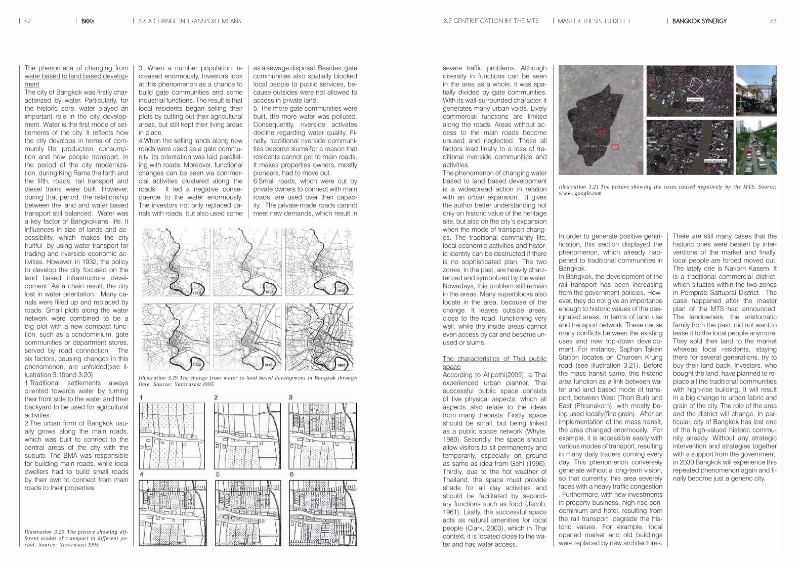
BKKs62 MASTER THESIS TU DELFT BANGKOK SYNERGY 633.6 A CHANGE IN TRANSPORT MEANS
3. When a number population in-creased enormously, Investors look at this phenomenon as a chance to build gate communities and some industrial functions. The result is that local residents began selling their plots by cutting out their agricultural areas, but still kept their living areas in place.4.When the selling lands along new roads were used as a gate commu-nity, its orientation was laid parallel-ing with roads. Moreover, functional changes can be seen via commer-cial activities clustered along the roads. It led a negative conse-quence to the water enormously. The investors not only replaced ca-nals with roads, but also used some
The phenomena of changing from water based to land based develop-mentThe city of Bangkok was firstly char-acterized by water. Particularly, for the historic core, water played an important role in the city develop-ment. Water is the first mode of set-tlements of the city. It reflects how the city develops in terms of com-munity life, production, consump-tion and how people transport. In the period of the city moderniza-tion, during King Rama the forth and the fifth, roads, rail transport and diesel trains were built. However, during that period, the relationship between the land and water based transport still balanced. Water was a key factor of Bangkokians’ life. It influences in size of lands and ac-cessibility, which makes the city fruitful by using water transport for trading and riverside economic ac-tivities. However, in 1932, the policy to develop the city focused on the land based infrastructure devel-opment. As a chain result, the city lost in water orientation. Many ca-nals were filled up and replaced by roads. Small plots along the water network were combined to be a big plot with a new compact func-tion, such as a condominium, gate communities or department stores, served by road connection. The six factors, causing changes in this phenomenon, are unfolded(see il-lustration 3.19and 3.20).1.Traditional settlements always oriented towards water by turning their front side to the water and their backyard to be used for agricultural activities.2.The urban form of Bangkok usu-ally grows along the main roads, which was built to connect to the central areas of the city with the suburb. The BMA was responsible for building main roads, while local dwellers had to build small roads by their own to connect from main roads to their properties.
severe traffic problems. Although diversity in functions can be seen in the area as a whole, it was spa-tially divided by gate communities. With its wall-surrounded character, it generates many urban voids. Lively commercial functions are limited along the roads. Areas without ac-cess to the main roads become unused and neglected. These all factors lead finally to a loss of tra-ditional riverside communities and activities.The phenomenon of changing water based to land based development is a widespread action in relation with an urban expansion. It gives the author better understanding not only on historic value of the heritage site, but also on the city’s expansion when the mode of transport chang-es. The traditional community life, local economic activities and histor-ic identity can be destructed if there is no sophisticated plan. The two zones, in the past, are heavily charz-terized and symbolized by the water. Nowadays, this problem still remain in the areas. Many superblocks also locate in the area, because of the change. It leaves outside areas, close to the road, functioning very well, while the inside areas cannot even access by car and become un-used or slums.
The characteristics of Thai public spaceAccording to Atipothi(2005), a Thai experienced urban planner, Thai successful public space consists of five physical aspects, which all aspects also relate to the ideas from many theorists. Firstly, space should be small, but being linked as a public space network (Whyte, 1980). Secondly, the space should allow visitors to sit permanently and temporarily, especially on ground as same as idea from Gehl (1996). Thirdly, due to the hot weather of Thailand, the space must provide shade for all day activities and should be facilitated by second-ary functions such as food (Jacob, 1961). Lastly, the successful space acts as natural amenities for local people (Clark, 2003), which in Thai context, it is located close to the wa-ter and has water access.
as a sewage disposal. Besides, gate communities also spatially blocked local people to public services, be-cause outsides were not allowed to access in private land.5. The more gate communities were built, the more water was polluted. Consequently, riverside activates decline regarding water quality. Fi-nally, traditional riverside communi-ties become slums for a reason that residents cannot get to main roads. It makes properties owners, mostly pioneers, had to move out.6.Small roads, which were cut by private owners to connect with main roads, are used over their capac-ity. The private-made roads cannot meet new demands, which result in
3.7 GENTRIFICATION BY THE MTS
Illustration 3.19 The change from water to land based development in Bangkok through time, Source: Yantrasast 1995
Illustration 3.20 The picture showing dif-ferent modes of transport in different pe-riod, Source: Yantrasast 1995
Illustration 3.21 The picture showing the cases caused negatively by the MTS, Source: www. google.com
There are still many cases that the historic ones were beaten by inter-ventions of the market and finally, local people are forced moved out. The lately one is Nakorn Kasem. It is a traditional commercial district, which situates within the two zones in Pomprab Sattuprai District. The case happened after the master plan of the MTS had announced. The landowners, the aristocratic family from the past, did not want to lease it to the local people anymore. They sold their land to the market whereas local residents, staying there for several generations, try to buy their land back. Investors, who bought the land, have planned to re-place all the traditional communities with high-rise building. It will result in a big change to urban fabric and grain of the city. The role of the area and the district will change. In par-ticular, city of Bangkok has lost one of the high-valued historic commu-nity already. Without any strategic intervention and strategies together with a support from the government, in 2030 Bangkok will experience this repeated phenomenon again and fi-nally become just a generic city.
In order to generate positive gentri-fication, this section displayed the phenomenon, which already hap-pened to traditional communities in Bangkok. In Bangkok, the development of the rail transport has been increasing from the government policies. How-ever, they do not give an importance enough to historic values of the des-ignated areas, in terms of land use and transport network. These cause many conflicts between the existing uses and new top-down develop-ment. For instance, Saphan Taksin Station locates on Charoen Krung road (see illustration 3.21). Before the mass transit came, this historic area function as a link between wa-ter and land based mode of trans-port, between West (Thon Buri) and East (Phranakorn), with mostly be-ing used locally(fine grain). After an implementation of the mass transit, the area changed enormously. For example, it is accessible easily with various modes of transport, resulting in many daily traders coming every day. This phenomenon conversely generate without a long-term vision, so that currently, this area severely faces with a heavy traffic congestion . Furthermore, with new investments in property business, high-rise con-dominium and hotel, resulting from the rail transport, degrade the his-toric values. For example, local opened market and old buildings were replaced by new architectures.
BKKs64 MASTER THESIS TU DELFT BANGKOK SYNERGY 653.8 CONCLUSION
Illustration 3.22 The diagram showing the framework of the whole project
MTS HeritageIntegration
NetworkCity
Heritage
- Proximity- Fine-grained pattern
Threat
- No right to be protected officially by law
Conflict
Social : - enclave tourism- market-oriented development- selectionSpatial :- building instead ofurban- facidism- authenticityEconomic :- Heritage as a product- Disneyfication- Tourist life cycle
Single concern
- Movement is not necessary- Distance is an end in itselfnot a means to an end- Virtual city- Inequity; mode, social status,location, urban activity - Lack of aspects related land use pattern
Non place
- Not meet local needs,heterotopias- Social segregation
Gentrification
- a loss of value, identity- generic city
- Traditional communities- Contain historic value- Still in use currently
Living HeritagePlace Making
- Face-to-face contact- Local interaction, benefits- Cohesion instead of segregation- Positive gentrification- Functional approachto prolong life span
Acessibility
URBAN VITALITY
- Flow, connectivity, multi-mode- Personal mobility(reduced mobility)- Opportunities- Improved land use accessibility
- Market control- Environment protection- Cross subsidization
MTS
- Link globalfunctions- Disengage atlocal levelphysically and functionally
- Places as a productof network- Impact on everydaypeople life process,movement
TOD
- Redevelopment alongtransit corridor
Mobility
- Diverse visitors broughtby connection- Connecing place to place
HeritageTourism
- Preserve historic valueand identity- Provide long-term development
Widespreadproblem
- Poverty- Urban sprawl- Heritage value lost- Automobiled oriented
Clash
- Clash in scale when impose on local level- Segregation of livingpattern- Spatial fragmentation
GLOBAL SCALE INTERVENTIONMass Transit System (MTS)
LOCAL SCALE INTERVENTIONHeritage
SYNERGYIntegrationNetwork + Urban formA SYNERGETIC VISION FOR A PATCHWORK LINKING GLOBALAND LOCAL SCALETesting location- Potential to integrate- High historic value- In danger by negative e�ects fromthe global scale intervention- Poorly connected within the spatial networkLandscape as community places- invite community engagement - build a sense of community andimprove quality of life- places to connect and interact- bring diverse mix of people
Goverment Support
- Diversity- Density- Non-motorized (Multi mode)- Proximity of network connectivity- Quality of space- Safety- Permeability
Spatial Indicators
- small space network- be able to sit- shaded area- relate to food- water access
Thai succcessful space ConflictPotential
HeritageValue
- Tradition and qualities ofa society- Important parts of its character
MTS HeritageIntegration
NetworkCity
Heritage
Threat
Conflict
Single concern
Non place
Gentrification
Living HeritagePlace MakingAcessibility
URBAN VITALITY
MTS
TOD
Mobility
HeritageTourism
Widespreadproblem
Clash
GLOBAL SCALE INTERVENTIONMass Transit System (MTS)
LOCAL SCALE INTERVENTIONHeritage
SYNERGYIntegrationNetwork + Urban form
Goverment Support
Spatial Indicators
Thai succcessful space ConflictPotential
HeritageValue
The conclusion of this chapter is that the urban and infrastructure de-velopment of Bangkok always rely heavily on each other. Due to the plan of the MTS, It brings positively a big opportunity to the city to solve traffic congestion, which its dwell-ers are struggling with nowadays. However, this development also generates a big threat. Because of a transformation of urban fabric of the city especially in the historic core of the city, a conflict between the two dynamics base on not only spatial conditions, but also social and economic differences. There-fore, this project aims mainly to pro-vide a synergetic vision and mutual benefits between the two in order to complement in harmony.
MTS HeritageIntegration
NetworkCity
Heritage
Threat
Conflict
Single concern
Non place
Gentrification
Living HeritagePlace MakingAcessibility
URBAN VITALITY
MTS
TOD
Mobility
HeritageTourism
Widespreadproblem
Clash
GLOBAL SCALE INTERVENTIONMass Transit System (MTS)
LOCAL SCALE INTERVENTIONHeritage
SYNERGYIntegrationNetwork + Urban form
Goverment Support
Spatial Indicators
Thai succcessful space ConflictPotential
HeritageValue
BKKs66
Source : www.skyscrapercity.com
67BANGKOK SYNERGYMASTER THESIS TU DELFT
Chapter 4EMPIRICAL RESEARCH

BKKs68 MASTER THESIS TU DELFT BANGKOK SYNERGY 69
In the first part of this section, it aims at choosing strategically the testing location, which highly needs to be intervened. The selection criteria have been developed based on four issues, which are spatial conditions, economic status, social dimen-sions and historic value. Therefore, the condition of the testing location is spatially fragmented and poorly connected, but has potentials to integrate within the network. It must contain high heritage value and still be in use nowadays. Lastly, the area is endangered by negative conse-quences from the rapid develop-ment and will get worse causing by segregation after the implementa-tion. The second part will provide in depth research on the current conditions of the strategic location and define the desirable goal, which will contribute to the next section in which the strategy will be proposed.
Illustration 4.01 showing general infor-mation of the nine districts classified into three crucial issues.
4.0 INTRODUCTION

BKKs70 MASTER THESIS TU DELFT BANGKOK SYNERGY 71
Selection criteriaIn order to know where is the strate-gic location that needs an interven-tion, the selection criteria has been developed. According to the previ-ous section, BMA already specifi-cally defined the development area as art, cultural preservation and tourism promotion zone, which are separated into nine districts along two sides of the river. The East and the West of the riverbank have dif-ferent characters, whereas they share similar historic components, which they both used to be capital city of the country of Thailand. The city settled on the West bank before moving to the East for military rea-sons. Therefore, both of them have strong historic values and impor-tant buildings (see illustration 4.3); for example, on the East, the grand palace, the national museum, the throne hall and many old temples are located and on the West, there are more traditional communities and living heritage.
Fortunately, the East bank already registered as city heritage sites, which literally means they have been protected officially by laws. Moreover, Bangkokians have learnt from the first implementation of the MTS in 1999 in that the market ini-tially intervened in the area, in which the land price was lower(see illus-tration 4.4). It represents that the land price on the West is five times lower than in the East. To conclude, the West bank is in danger to get a threat by the MTS and requires more research to prevent and keep it maintaining in 2030. The following part will focus spatial analysis on the west bank in order to know current conditions of the area.
4.1 SELECTION CRITERIA
Illustration 4.2 showing the selection criteria searching for vulnerable areas that highly need interventions
Illustration 4.3 showing significant build-ings on both sides of the river Illustration 4.04 showing land price on the catchment area of the historic core, Source : the Treasury Department
EAST BANKWEST BANK
$
+5
0
Negative conse-quences by the MTS
Threat by the market
Historic value
Connectivity to the MTS
Potential to develop
EAST BANKWEST BANK
East bank : registered heritage
West bank : unregistered heritage
4.1 SELECTION CRITERIA

MASTER THESIS TU DELFTBKKs BANGKOK SYNERGY72 73
Illustration 4.5 showing spatial connection : Global and Local Integration
Illustration 4.7 showing current condition of public transport catchment
Illustration 4.8 showing spatial accessibil-ity to the MTS in 2030
Illustration 4.9 showing transport catch-ment in 2030
Illustration 4.10 showing catchment area of the complementary mode of transport in 2030
The illustration 4.06 reveals the three steps analysis, which shows the in-ner areas from the main road need complicated ways to reach. Moreo-ver, together with the public trans-port catchment, it displays that the far away areas can be reached only by private transport (see illustration 4.7). Besides in 2030 (see illustration 4.8 & 4.9), when the urban network improves enormously, there are still some remaining voids,especially even combined with the privately owned transport like the motor cycle taxi (see illustration 4.10).
Note: The motor cycle taxi is the ba-sic mode of transport of Bangkoki-ans. With the long time car based development, it is widely acceptable and has been considered as pre transport mode for a short commute within two kilometers radius.
Spatial conditionsZooming in to the West, the illustra-tion 4.5 shows an axial analysis on the network of streets and avenues that organize the area. Warm colors indicate areas with more street-level integration; this means streets that intersect a greater number of other streets of the network. We can see the area has a small role in the glo-bal level only on the north south connection from the warm colors ,and it integrates more on the lo-cal level. The map also represents fragmented areas. The fragmented areas can be seen how hard people getting to the area are.
Illustration 4.6 showing current condition of accessibility of the area
High integration
Low integration
Boat 100 m.
Bus, minivan 300 m
MTS 500 m
4.1 SELECTION CRITERIA
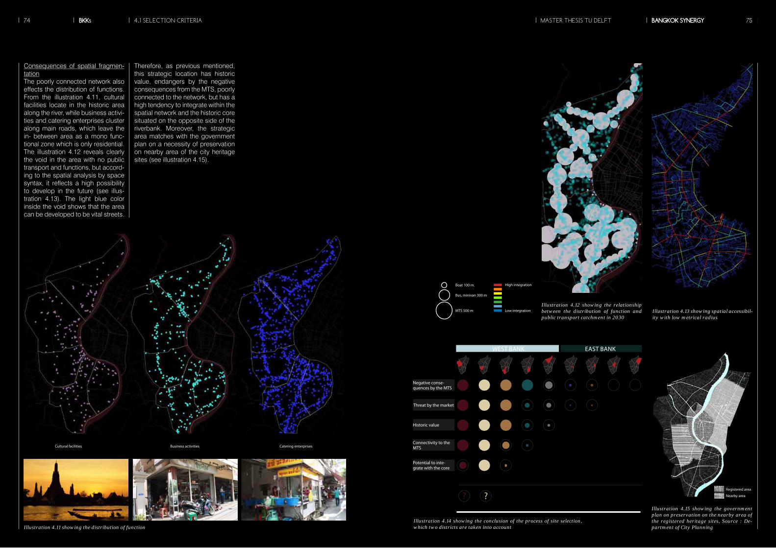
Illustration 4.11 showing the distribution of function
Illustration 4.12 showing the relationship between the distribution of function and public transport catchment in 2030
Illustration 4.13 showing spatial accessibil-ity with low metrical radius
Consequences of spatial fragmen-tationThe poorly connected network also effects the distribution of functions. From the illustration 4.11, cultural facilities locate in the historic area along the river, while business activi-ties and catering enterprises cluster along main roads, which leave the in- between area as a mono func-tional zone which is only residential. The illustration 4.12 reveals clearly the void in the area with no public transport and functions, but accord-ing to the spatial analysis by space syntax, it reflects a high possibility to develop in the future (see illus-tration 4.13). The light blue color inside the void shows that the area can be developed to be vital streets.
Therefore, as previous mentioned, this strategic location has historic value, endangers by the negative consequences from the MTS, poorly connected to the network, but has a high tendency to integrate within the spatial network and the historic core situated on the opposite side of the riverbank. Moreover, the strategic area matches with the government plan on a necessity of preservation on nearby area of the city heritage sites (see illustration 4.15).
High integration
Low integration
Boat 100 m.
Bus, minivan 300 m
MTS 500 m
Cultural facilities Business activities Catering enterprises
Illustration 4.14 showing the conclusion of the process of site selection, which two districts are taken into account
Illustration 4.15 showing the government plan on preservation on the nearby area of the registered heritage sites, Source : De-partment of City Planning
Negative conse-quences by the MTS
Threat by the market
Historic value
Connectivity to the MTS
Potential to inte-grate with the core
? ?
EAST BANKWEST BANK
Registered area
Nearby area
MASTER THESIS TU DELFTBKKs BANGKOK SYNERGY74 754.1 SELECTION CRITERIA
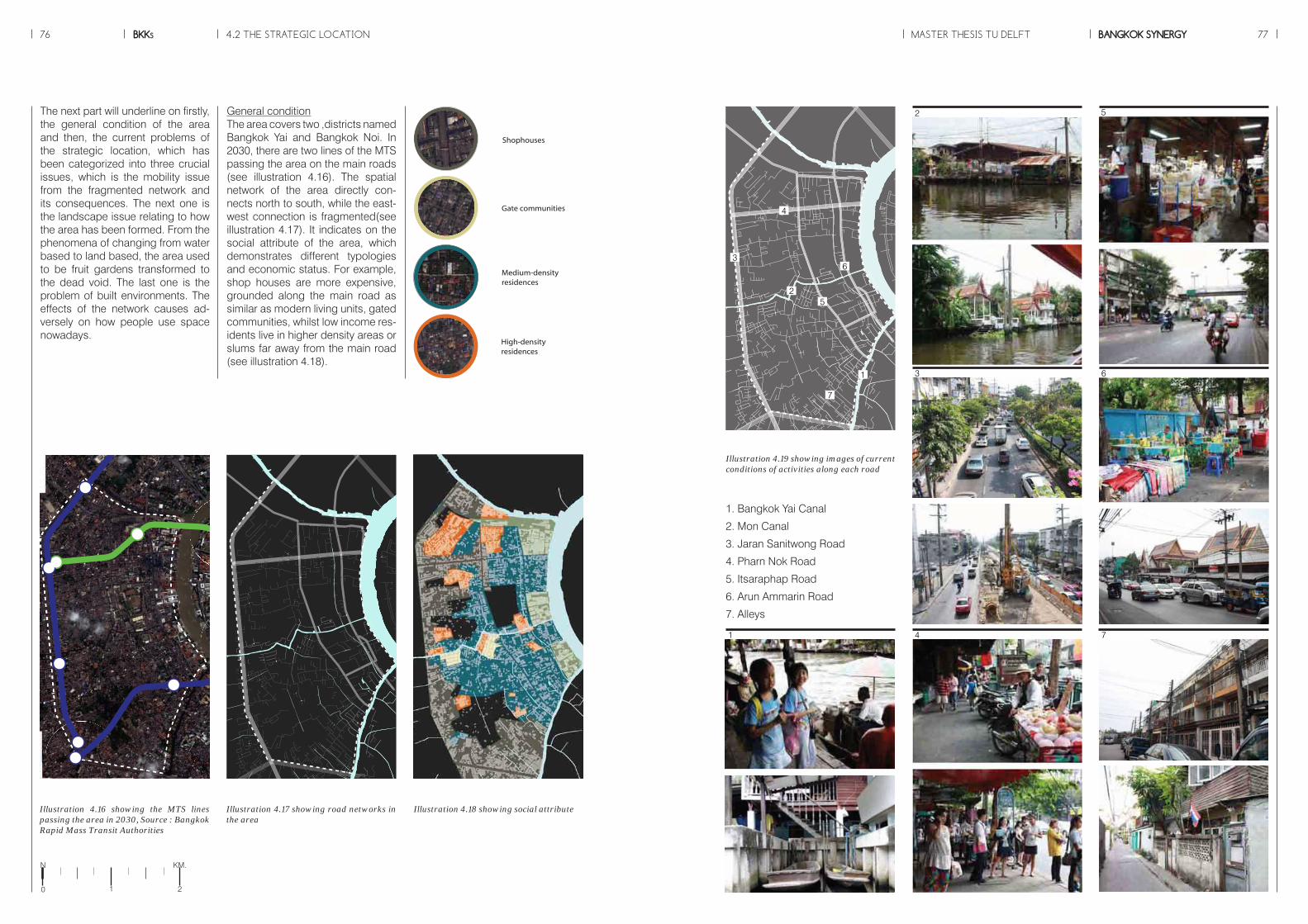
BKKs76 MASTER THESIS TU DELFT BANGKOK SYNERGY 77
General conditionThe area covers two ,districts named Bangkok Yai and Bangkok Noi. In 2030, there are two lines of the MTS passing the area on the main roads (see illustration 4.16). The spatial network of the area directly con-nects north to south, while the east-west connection is fragmented(see illustration 4.17). It indicates on the social attribute of the area, which demonstrates different typologies and economic status. For example, shop houses are more expensive, grounded along the main road as similar as modern living units, gated communities, whilst low income res-idents live in higher density areas or slums far away from the main road (see illustration 4.18).
The next part will underline on firstly, the general condition of the area and then, the current problems of the strategic location, which has been categorized into three crucial issues, which is the mobility issue from the fragmented network and its consequences. The next one is the landscape issue relating to how the area has been formed. From the phenomena of changing from water based to land based, the area used to be fruit gardens transformed to the dead void. The last one is the problem of built environments. The effects of the network causes ad-versely on how people use space nowadays.
4.2 THE STRATEGIC LOCATION
Illustration 4.19 showing images of current conditions of activities along each road
Illustration 4.16 showing the MTS lines passing the area in 2030, Source : Bangkok Rapid Mass Transit Authorities
Illustration 4.17 showing road networks in the area
Illustration 4.18 showing social attribute
Shophouses
Gate communities
Medium-density residences
High-density residences
1. Bangkok Yai Canal
2. Mon Canal
3. Jaran Sanitwong Road
4. Pharn Nok Road
5. Itsaraphap Road
6. Arun Ammarin Road
7. Alleys
1
2
7
6
4
3
5
1
2
7
6
4
3
5
N
0 21
KM.
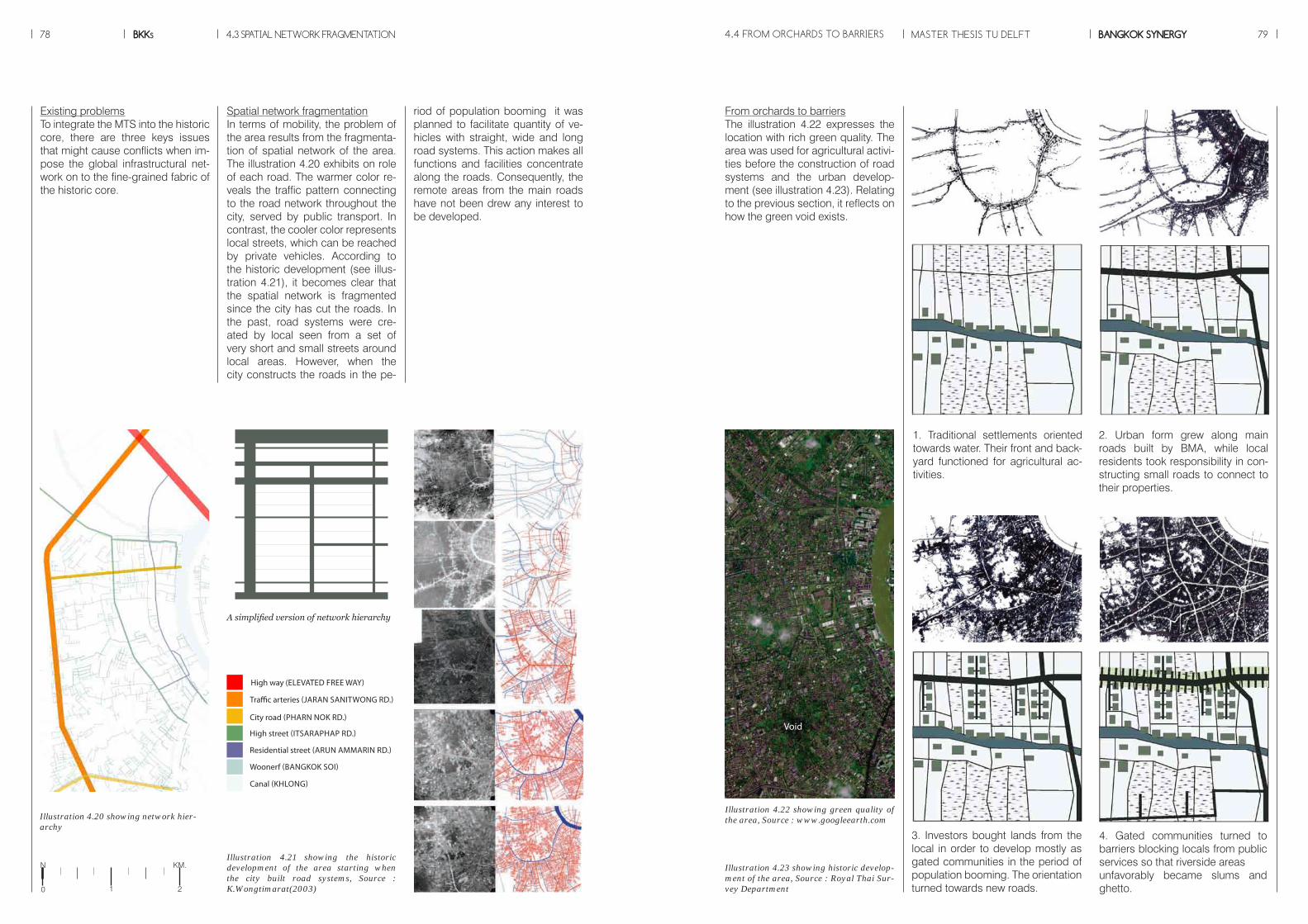
BKKs78 MASTER THESIS TU DELFT BANGKOK SYNERGY 79
From orchards to barriersThe illustration 4.22 expresses the location with rich green quality. The area was used for agricultural activi-ties before the construction of road systems and the urban develop-ment (see illustration 4.23). Relating to the previous section, it reflects on how the green void exists.
4.3 SPATIAL NETWORK FRAGMENTATION
Spatial network fragmentationIn terms of mobility, the problem of the area results from the fragmenta-tion of spatial network of the area. The illustration 4.20 exhibits on role of each road. The warmer color re-veals the traffic pattern connecting to the road network throughout the city, served by public transport. In contrast, the cooler color represents local streets, which can be reached by private vehicles. According to the historic development (see illus-tration 4.21), it becomes clear that the spatial network is fragmented since the city has cut the roads. In the past, road systems were cre-ated by local seen from a set of very short and small streets around local areas. However, when the city constructs the roads in the pe-
riod of population booming it was planned to facilitate quantity of ve-hicles with straight, wide and long road systems. This action makes all functions and facilities concentrate along the roads. Consequently, the remote areas from the main roads have not been drew any interest to be developed.
Existing problemsTo integrate the MTS into the historic core, there are three keys issues that might cause conflicts when im-pose the global infrastructural net-work on to the fine-grained fabric of the historic core.
Illustration 4.21 showing the historic development of the area starting when the city built road systems, Source : K.Wongtimarat(2003)
A simplified version of network hierarchy
Illustration 4.23 showing historic develop-ment of the area, Source : Royal Thai Sur-vey Department
Illustration 4.22 showing green quality of the area, Source : www.googleearth.comIllustration 4.20 showing network hier-
archy
Woonerf (BANGKOK SOI)
Canal (KHLONG)
Residential street (ARUN AMMARIN RD.)
High street (ITSARAPHAP RD.)
Traffic arteries (JARAN SANITWONG RD.)
High way (ELEVATED FREE WAY)
City road (PHARN NOK RD.)
4.4 FROM ORCHARDS TO BARRIERS
1. Traditional settlements oriented towards water. Their front and back-yard functioned for agricultural ac-tivities.
2. Urban form grew along main roads built by BMA, while local residents took responsibility in con-structing small roads to connect to their properties.
3. Investors bought lands from the local in order to develop mostly as gated communities in the period of population booming. The orientation turned towards new roads.
4. Gated communities turned to barriers blocking locals from public services so that riverside areas unfavorably became slums and ghetto.
Void
N
0 21
KM.
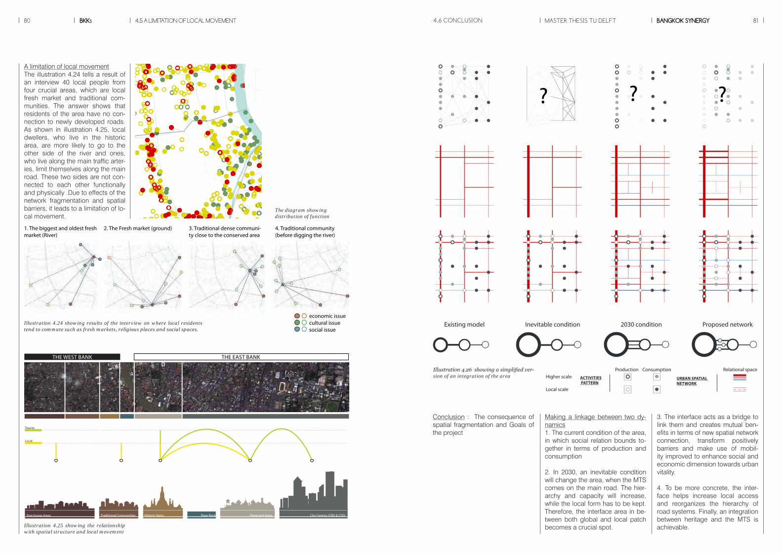
BKKs80 MASTER THESIS TU DELFT BANGKOK SYNERGY 81
A limitation of local movementThe illustration 4.24 tells a result of an interview 40 local people from four crucial areas, which are local fresh market and traditional com-munities. The answer shows that residents of the area have no con-nection to newly developed roads. As shown in illustration 4.25, local dwellers, who live in the historic area, are more likely to go to the other side of the river and ones, who live along the main traffic arter-ies, limit themselves along the main road. These two sides are not con-nected to each other functionally and physically .Due to effects of the network fragmentation and spatial barriers, it leads to a limitation of lo-cal movement.
Conclusion : The consequence of spatial fragmentation and Goals of the project
Making a linkage between two dy-namics1. The current condition of the area, in which social relation bounds to-gether in terms of production and consumption
2. In 2030, an inevitable condition will change the area, when the MTS comes on the main road. The hier-archy and capacity will increase, while the local form has to be kept. Therefore, the interface area in be-tween both global and local patch becomes a crucial spot.
3. The interface acts as a bridge to link them and creates mutual ben-efits in terms of new spatial network connection, transform positively barriers and make use of mobil-ity improved to enhance social and economic dimension towards urban vitality.
4. To be more concrete, the inter-face helps increase local access and reorganizes the hierarchy of road systems. Finally, an integration between heritage and the MTS is achievable.
4.5 A LIMITATION OF LOCAL MOVEMENT
1. The biggest and oldest fresh market (River)
2. The Fresh market (ground) 3. Traditional dense communi-ty close to the conserved area
4. Traditional community (before digging the river)
economic issuecultural issuesocial issue
Illustration 4.24 showing results of the interview on where local residents tend to commute such as fresh markets, religious places and social spaces.
Illustration 4.25 showing the relationship with spatial structure and local movement
Illustration 4.26 showing a simplified ver-sion of an integration of the area
New Development Areas Traditional Communities Historic Items Preserved Areas City Centres (CBD & CSD)River Bank
Row house Areas
Tourist
Local
Newcomer
Traditional Communities Historic Items Preserved Areas City Centres (CBD & CSD)River Bank
Tourist
Local
THE WEST BANK THE EAST BANK
The diagram showingdistribution of function
4.6 CONCLUSION
Existing model
Consumption Relational space
URBAN SPATIAL NETWORK
Production
Local scale
Higher scale
? ?? ? ?? ? ?? ? ??
ACTIVITIES PATTERN
Inevitable condition 2030 condition Proposed network
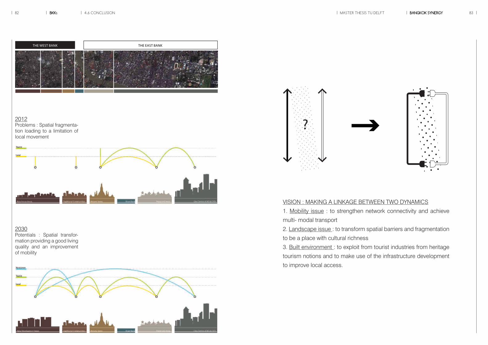
BKKs82 MASTER THESIS TU DELFT BANGKOK SYNERGY 83
THE WEST BANK THE EAST BANK
Problems : Spatial fragmenta-tion loading to a limitation of local movement
Potentials : Spatial transfor-mation providing a good living quality and an improvement of mobility
?
VISION : MAKING A LINKAGE BETWEEN TWO DYNAMICS
1. Mobility issue : to strengthen network connectivity and achieve
multi- modal transport
2. Landscape issue : to transform spatial barriers and fragmentation
to be a place with cultural richness
3. Built environment : to exploit from tourist industries from heritage
tourism notions and to make use of the infrastructure development
to improve local access.
2012
2030
4.6 CONCLUSION
BKKs84
Source : www.skyscrapercity.com
MASTER THESIS TU DELFT BANGKOK SYNERGY 85
STRATEGYChapter 5
Source : www.kabegamilink.com
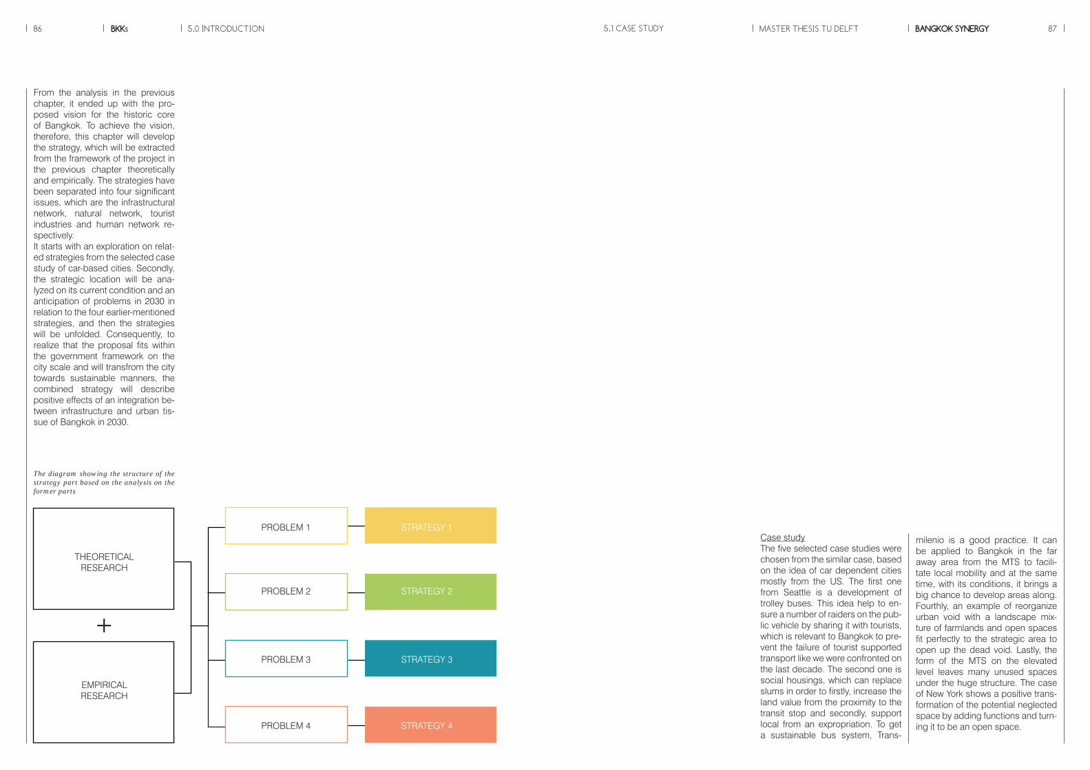
MASTER THESIS TU DELFTBKKs BANGKOK SYNERGY86 87
milenio is a good practice. It can be applied to Bangkok in the far away area from the MTS to facili-tate local mobility and at the same time, with its conditions, it brings a big chance to develop areas along. Fourthly, an example of reorganize urban void with a landscape mix-ture of farmlands and open spaces fit perfectly to the strategic area to open up the dead void. Lastly, the form of the MTS on the elevated level leaves many unused spaces under the huge structure. The case of New York shows a positive trans-formation of the potential neglected space by adding functions and turn-ing it to be an open space.
Case studyThe five selected case studies were chosen from the similar case, based on the idea of car dependent cities mostly from the US. The first one from Seattle is a development of trolley buses. This idea help to en-sure a number of raiders on the pub-lic vehicle by sharing it with tourists, which is relevant to Bangkok to pre-vent the failure of tourist supported transport like we were confronted on the last decade. The second one is social housings, which can replace slums in order to firstly, increase the land value from the proximity to the transit stop and secondly, support local from an expropriation. To get a sustainable bus system, Trans-
From the analysis in the previous chapter, it ended up with the pro-posed vision for the historic core of Bangkok. To achieve the vision, therefore, this chapter will develop the strategy, which will be extracted from the framework of the project in the previous chapter theoretically and empirically. The strategies have been separated into four significant issues, which are the infrastructural network, natural network, tourist industries and human network re-spectively. It starts with an exploration on relat-ed strategies from the selected case study of car-based cities. Secondly, the strategic location will be ana-lyzed on its current condition and an anticipation of problems in 2030 in relation to the four earlier-mentioned strategies, and then the strategies will be unfolded. Consequently, to realize that the proposal fits within the government framework on the city scale and will transfrom the city towards sustainable manners, the combined strategy will describe positive effects of an integration be-tween infrastructure and urban tis-sue of Bangkok in 2030.
5.0 INTRODUCTION 5.1 CASE STUDY
THEORETICAL RESEARCH
EMPIRICALRESEARCH
+
PROBLEM 1 STRATEGY 1
PROBLEM 2 STRATEGY 2
PROBLEM 3 STRATEGY 3
PROBLEM 4 STRATEGY 4
The diagram showing the structure of the strategy part based on the analysis on the former parts
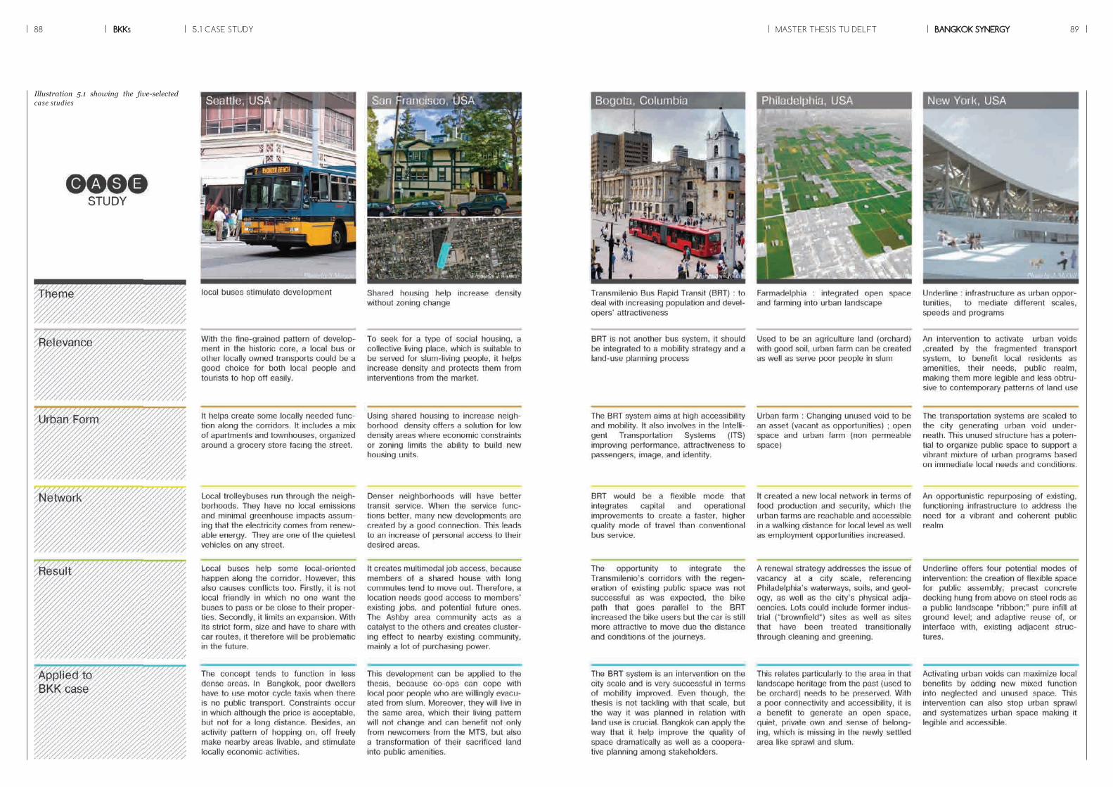
BKKs88 MASTER THESIS TU DELFT BANGKOK SYNERGY 895.1 CASE STUDY
Illustration 5.1 showing the five-selected case studies

BKKs90 MASTER THESIS TU DELFT BANGKOK SYNERGY 91
From the long-term car oriented de-velopment, the city structure can be categorized by urban grid size into four types. Grid size displays not only how hard it is to get to the area, but also an opportunity to catch on public transports. The brown color represents the smallest grid size, which clusters mostly around the historic core on east bank of the riv-er (see illustration 5.2). However, on the west bank is not coherent. It has more mix of colors and, especially in the strategic area has 3x3-grid structure, which leads to a limitation of movement and spatial fragmen-tations.
Zooming in to the area, it illustrates that there is no secondary roads to connect. Besides, when it has been compared to other cities or even the area on the opposite site of the river-bank, the coherence of spatial con-nection is very low and much more fragmented (see illustration 5.3).In terms of public transport, when there is no spatial connection, there is no public transport too. It results in travel distance constraints. Lo-cal residents rely mostly on private vehicles, while public transport has been served only along main roads (see illustration 5.4). Therefore, the mode of transport of Bangkok is special in that it requires a comple-mentary mode. This mode consid-ers privately owned transport as a pre transport within a short distance (R=2km.) before riding on public transport for a long distance (see il-lustration 5.5).
5.2 INFRASTRUCTURAL NETWORK
THE WEST BANK
THE EASTBANK
BANGKOK
COMPLIMENTARY MODE
PUBLIC TRANSPORT PRIVATE TRANSPORT
1x1
2x2
3x3
4x4
KM.
N
0 10 20
KM.
Illustration 5.2 showing the urban grid structure of the city of Bangkok, Source : R.Kanjanapanyakom(2010)
Illustration 5.3 showing a comparison of urban grid structure among other cities, Source : www.doobybrain.com
Illustration 5.5 showing complementary modes of transport in Bangkok.
Illustration 5.4 showing different mode of transport served in 2012
N
0 21
KM.
1X1 KM.

BKKs92 MASTER THESIS TU DELFT BANGKOK SYNERGY 93
Therefore, for Bangkok in 2030, a co-operation between private and pub-lic transport leads to large choices of transport and provide access to all ranges of people (see illustration 5.9). Eventually a five-minute city is achievable, which means within five minutes one can get into the transport system and travel freely throughout the entire city.
The effects of the strategy reveal a new coherent grid system by mak-ing new connections. The illustra-tion 5.8 shows that the existing spa-tial structure has been undersized especially in the historic core of the city characterized by small grid structures.
Proposed strategy on infrastructural networkThe goal of this strategy is to con-nect and reorganize the spatial net-work hierarchy in a systematic way. First of all, according to the space syntax analysis, it shows the poten-tial streets to be developed to vital streets in terms of spatial connec-tion. The strategy will focus on those streets and next reorganize spatial fragmentations of road network hi-erarchy. When the street has already been organized (see illustration
5.6), it reflects a big tendency to ac-complish multi-modal transport by emphasizing on the contemporary modes, which privately owned vehi-cles are used within short distance, while public transports are able to serve long journeys (see illustration 5.7).
5.2 INFRASTRUCTURAL NETWORK
Infrastructural network
Natural network
Human network
Tourist
Business
New connections provide new access to the existing urban systems and work as stimulants for future densi�cation and mixed develop-ment in monofuntional fragments
The borders of built urban fabric adjacent to open space are densi�ed surrounded open protected spaces as a permeable barrier.New living and working environments are created which bene�t from both urban proxim-ity to accss and open spaces
New connections help break through the urban super grids of Bangkok ,caused by mobile dependent development, and reorganize the hierarchy of road systems in the systematic way.
By transforming urban fragmentations, the neglected green between the two patchs, global and local, become a crucial resource for urban quality. A barrier is turned out to be active and livable spaces.
Connect potential existing road
Multi - modal transportachieved
Density gradient
Various experiences
Tranform grid to curvilinearpattern
Maximizing interactionson the border
Linear green connectors and slow tra�c
Di�erent time consuming Shared transport with localto increase riderships
Densifying potential areas byexploiting new connections
Programme clusters aroundthe new open space
Reorganize the hierarchyof the road system
SL
M
M
x
N
0 10 20
KM.
1x1
2x2
3x3
4x4
KM.
PROPOSED TRANSPORT
Illustration 5.6 showing desirable road network hierarchy in 2030
Illustration 5.8 showing a coherent grid structure from new connections
Illustration 5.7 showing proposed public transport modes in order to achieve a com-plementary mode
N
0 10 20
KM.
Illustration 5.9 showing spatial network of public transport of Bangkok in 2030
MTSBRTBus
x
Proposed mode
N
0 21
KM.

BKKs94 MASTER THESIS TU DELFT BANGKOK SYNERGY 955.3 NATURAL NETWORK
Looking at the green network of Bangkok, it is much dispersed. Lit-erally, it shows 0.25 percentages of green areas per person. Unfortu-nately, most of them are not acces-sible that in particular on the west, there is no public open space de-signed for local residents (see illus-tration 5.10). To zoom in to the strategic location, the urban void represents the fact that the rich green quality still lasts seen via existing fruit gardens and historic stream run through, which exhibits great potentials to inter-vene. However, when no one uses it, it turns to be barriers (see illustra-tion 5.11).
FRUIT GARDEN HISTORIC STREAM
NATURAL WALL
SPRAWL
NO USE
GARBAGE
N
0 10 20
KM.
Accessible greens by public transport
Inaccessible greens by public transport
Urban fabric
Illustration 5.10 showing a dispersion of green network in Bangkok, Source : R.Kanjanapanyakom(2010)
Illustration 5.11 showing current condition of the urban void, Source : www.googlee-arth.com
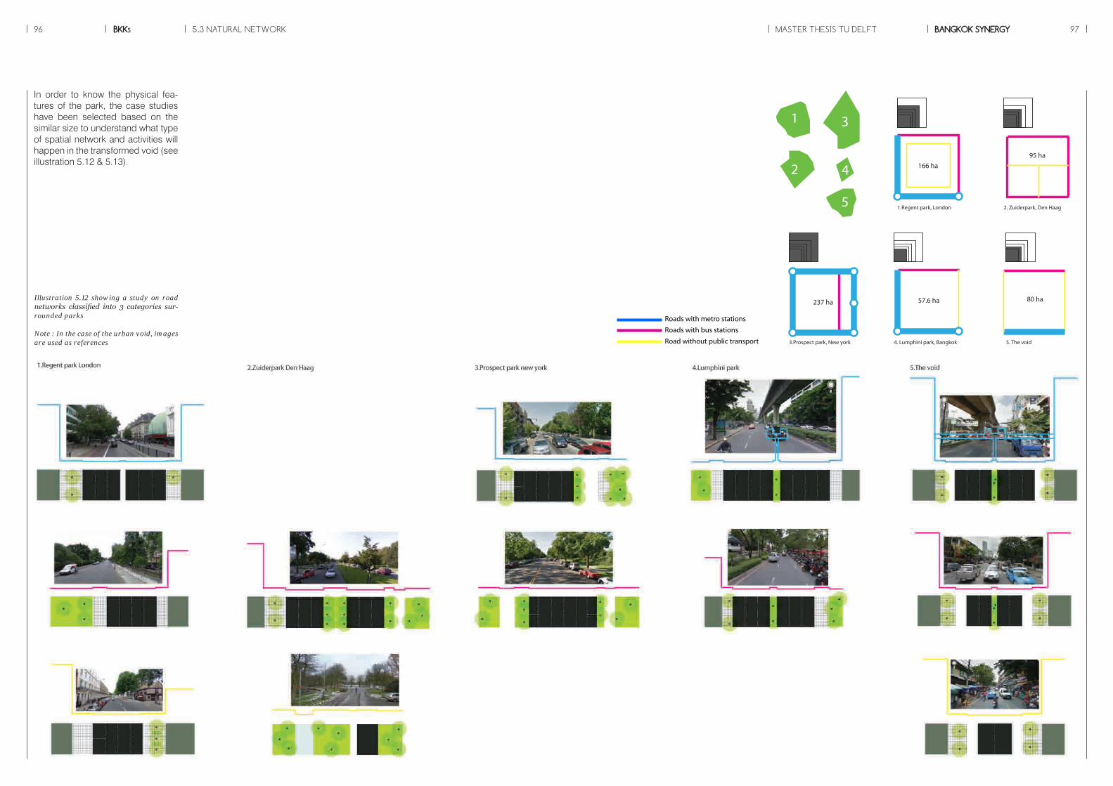
BKKs96 MASTER THESIS TU DELFT BANGKOK SYNERGY 97
80 ha
5. The void
95 ha
2. Zuiderpark, Den Haag
57.6 ha
4. Lumphini park, Bangkok
166 ha
1.Regent park, London
237 ha
3.Prospect park, New york
1
2
3
4
5
80 ha
5. The void
95 ha
2. Zuiderpark, Den Haag
57.6 ha
4. Lumphini park, Bangkok
166 ha
1.Regent park, London
237 ha
3.Prospect park, New york
1
2
3
4
5
80 ha
5. The void
95 ha
2. Zuiderpark, Den Haag
57.6 ha
4. Lumphini park, Bangkok
166 ha
1.Regent park, London
237 ha
3.Prospect park, New york
1
2
3
4
5
In order to know the physical fea-tures of the park, the case studies have been selected based on the similar size to understand what type of spatial network and activities will happen in the transformed void (see illustration 5.12 & 5.13).
Illustration 5.12 showing a study on road networks classified into 3 categories sur-rounded parks
Note : In the case of the urban void, images are used as references
5.3 NATURAL NETWORK
Roads with metro stationsRoads with bus stationsRoad without public transport
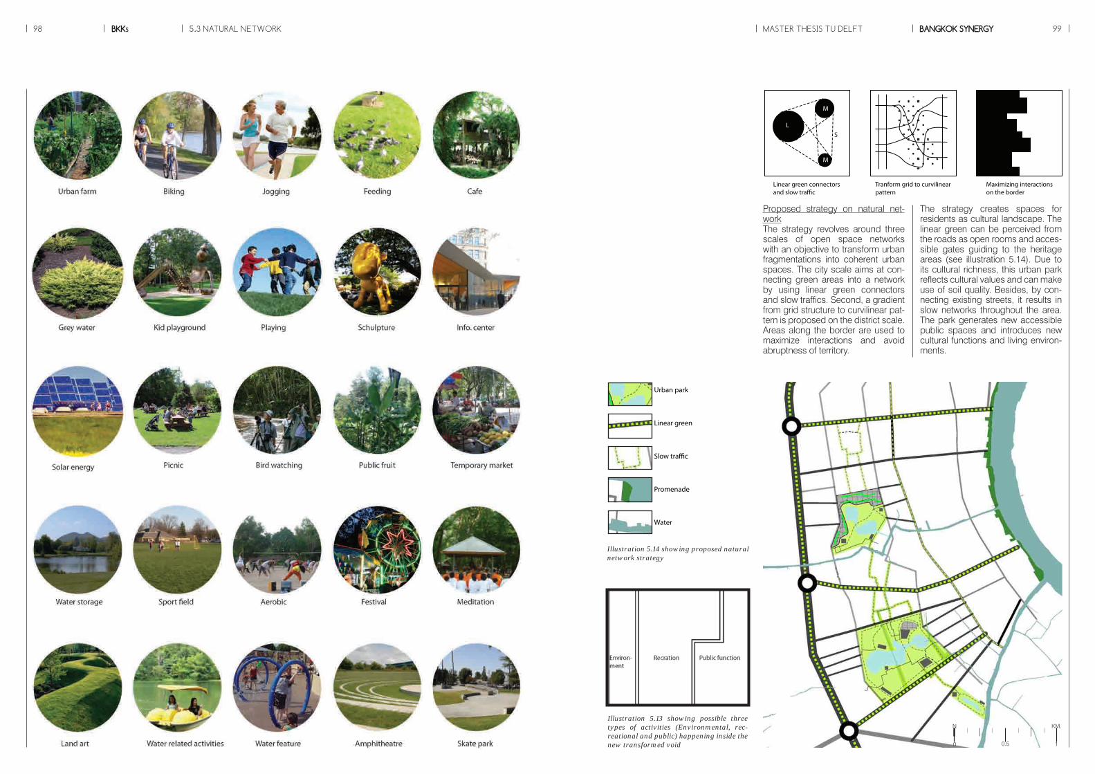
BKKs98 MASTER THESIS TU DELFT BANGKOK SYNERGY 99
Proposed strategy on natural net-workThe strategy revolves around three scales of open space networks with an objective to transform urban fragmentations into coherent urban spaces. The city scale aims at con-necting green areas into a network by using linear green connectors and slow traffics. Second, a gradient from grid structure to curvilinear pat-tern is proposed on the district scale. Areas along the border are used to maximize interactions and avoid abruptness of territory.
The strategy creates spaces for residents as cultural landscape. The linear green can be perceived from the roads as open rooms and acces-sible gates guiding to the heritage areas (see illustration 5.14). Due to its cultural richness, this urban park reflects cultural values and can make use of soil quality. Besides, by con-necting existing streets, it results in slow networks throughout the area. The park generates new accessible public spaces and introduces new cultural functions and living environ-ments.
Infrastructural network
Natural network
Human network
Tourist
Business
New connections provide new access to the existing urban systems and work as stimulants for future densi�cation and mixed develop-ment in monofuntional fragments
The borders of built urban fabric adjacent to open space are densi�ed surrounded open protected spaces as a permeable barrier.New living and working environments are created which bene�t from both urban proxim-ity to accss and open spaces
New connections help break through the urban super grids of Bangkok ,caused by mobile dependent development, and reorganize the hierarchy of road systems in the systematic way.
By transforming urban fragmentations, the neglected green between the two patchs, global and local, become a crucial resource for urban quality. A barrier is turned out to be active and livable spaces.
Connect potential existing road
Multi - modal transportachieved
Density gradient
Various experiences
Tranform grid to curvilinearpattern
Maximizing interactionson the border
Linear green connectors and slow tra�c
Di�erent time consuming Shared transport with localto increase riderships
Densifying potential areas byexploiting new connections
Programme clusters aroundthe new open space
Reorganize the hierarchyof the road system
SL
M
M
x
Urban park
Linear green
Slow traffic
Promenade
Water
N
0 10.5
KM.
Illustration 5.14 showing proposed natural network strategy
5.3 NATURAL NETWORK
Illustration 5.13 showing possible three types of activities (Environmental, rec-reational and public) happening inside the new transformed void
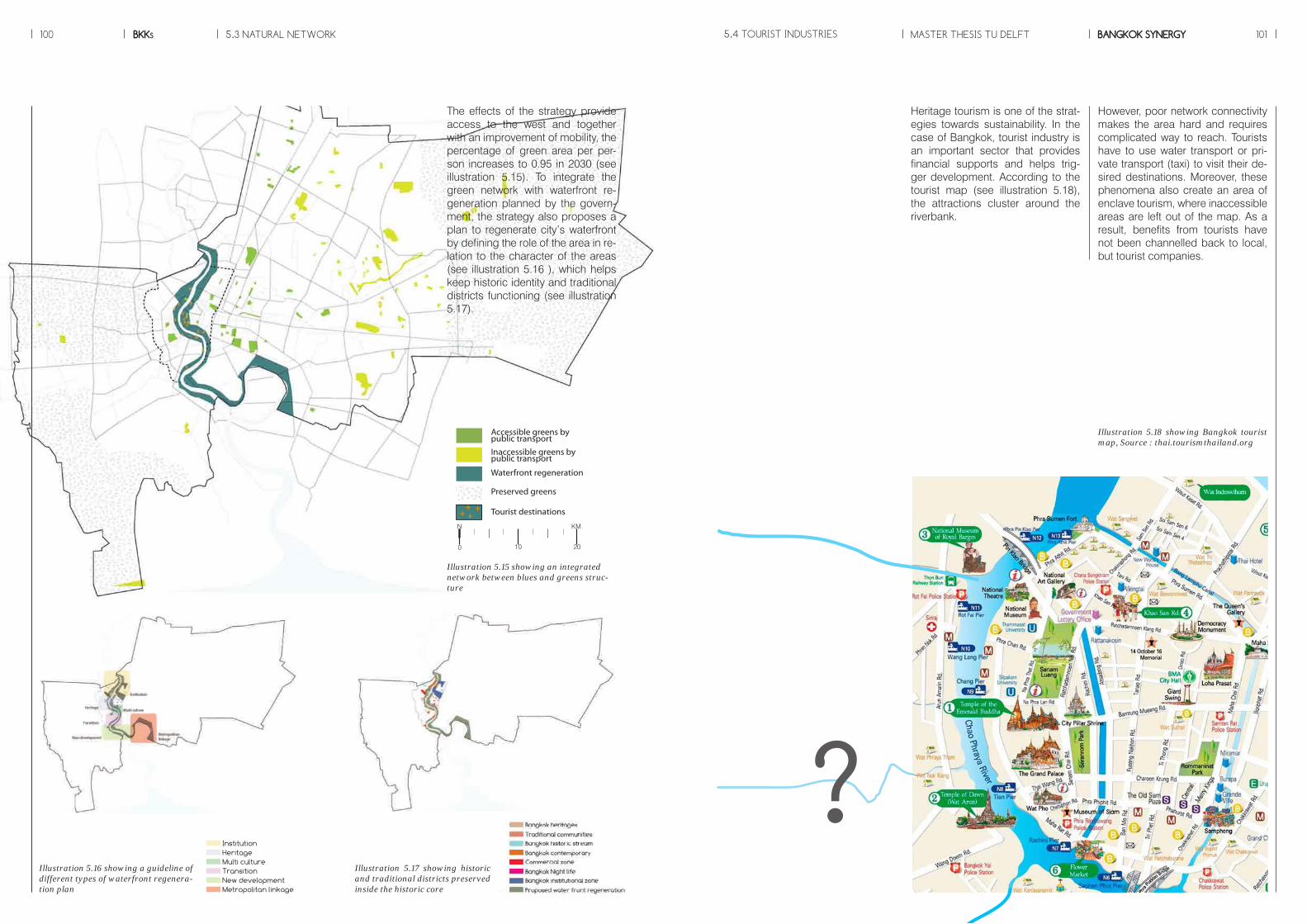
?
Illustration 5.18 showing Bangkok tourist map, Source : thai.tourismthailand.org
However, poor network connectivity makes the area hard and requires complicated way to reach. Tourists have to use water transport or pri-vate transport (taxi) to visit their de-sired destinations. Moreover, these phenomena also create an area of enclave tourism, where inaccessible areas are left out of the map. As a result, benefits from tourists have not been channelled back to local, but tourist companies.
Heritage tourism is one of the strat-egies towards sustainability. In the case of Bangkok, tourist industry is an important sector that provides financial supports and helps trig-ger development. According to the tourist map (see illustration 5.18), the attractions cluster around the riverbank.
Accessible greens by public transport
Inaccessible greens by public transport
Preserved greens
Waterfront regeneration
Tourist destinations+ +++
N
0 10 20
KM.
Illustration 5.15 showing an integrated network between blues and greens struc-ture
InstitutionHeritageMulti cultureTransitionNew developmentMetropolitan linkage
Illustration 5.16 showing a guideline of different types of waterfront regenera-tion plan
Illustration 5.17 showing historic and traditional districts preserved inside the historic core
5.3 NATURAL NETWORK 5.4 TOURIST INDUSTRIES
The effects of the strategy provide access to the west and together with an improvement of mobility, the percentage of green area per per-son increases to 0.95 in 2030 (see illustration 5.15). To integrate the green network with waterfront re-generation planned by the govern-ment, the strategy also proposes a plan to regenerate city’s waterfront by defining the role of the area in re-lation to the character of the areas (see illustration 5.16 ), which helps keep historic identity and traditional districts functioning (see illustration 5.17).
MASTER THESIS TU DELFTBKKs BANGKOK SYNERGY100 101

BKKs102 MASTER THESIS TU DELFT BANGKOK SYNERGY 103
The effects of this strategy bring much potential to connect and re-organize the existing fragmented network. Together with aforemen-tioned strategies on infrastructure and open space network, the vital streets have a tendency to be con-nected, densified, added new pro-gramme and regenerated environ-mental quality (see illustration 5.20).
5.4 TOURIST INDUSTRIES
Infrastructural network
Natural network
Human network
Tourist
Business
New connections provide new access to the existing urban systems and work as stimulants for future densi�cation and mixed develop-ment in monofuntional fragments
The borders of built urban fabric adjacent to open space are densi�ed surrounded open protected spaces as a permeable barrier.New living and working environments are created which bene�t from both urban proxim-ity to accss and open spaces
New connections help break through the urban super grids of Bangkok ,caused by mobile dependent development, and reorganize the hierarchy of road systems in the systematic way.
By transforming urban fragmentations, the neglected green between the two patchs, global and local, become a crucial resource for urban quality. A barrier is turned out to be active and livable spaces.
Connect potential existing road
Multi - modal transportachieved
Density gradient
Various experiences
Tranform grid to curvilinearpattern
Maximizing interactionson the border
Linear green connectors and slow tra�c
Di�erent time consuming Shared transport with localto increase riderships
Densifying potential areas byexploiting new connections
Programme clusters aroundthe new open space
Reorganize the hierarchyof the road system
SL
M
M
x
CURRENT CONDITION PROPOSED CONDITION
Deadend : to be connected Woonerf : to be densified Global road: to be addedprogrammes
Water : to be regenerated Local road : as references
7 8 6
6 25 4
12
11
10
3
1
Illustration 5.20 showing potential areas to be developed
The diagram showing different characters of area along the routes providing various experiences
Due to the earlier mentioned strate-gy, when the way to travel becomes more convenient by a large choice of transport. Tourists will be able to choose how to travel and what kind of experiences to be perceived such as, riverside communities, and tra-ditional commercial district. Eventu-ally, the route for tourists become a completed loop by not only focus-ing on one side of the river (see il-lustration 5.19)
Illustration 5.19 showing a Bangkok tourist map in 2030 (current tourist destinations colored in red)
Proposed strategy on tourist indus-triesThe goal of the strategy is to pro-mote cultural and heritage tourism with local benefits. Visitors can en-joy specific characters of the histor-ic area with various experiences of routes, which they choose. In addi-tion, the strategy offers different op-tions of time consuming with many modes of transport. To keep appro-priate number of raiders, tourist bus will not be separated independently only for travelling purposes, but it will be shared with local resident to increase ridership.
N
0 21
KM.

The result of new connections bring a lot of opportunities to the area, which increase density along new road with mix functions served all social classes. It helps shorten trav-el distance and improve access for residents to create living and work-ing environments. (see illustration 5.21)
Proposed strategy on human net-workThe proposal defines a density gradient, which high density con-centrates along the transit corridor, while faraway areas have lower density. The new opened-up open space attracts new programmes. Lastly, the potential streets can be densified by exploiting chances from new connections.
The strategy on human network is a result of a combination of the three strategies in order to use new con-nections as catalysts.
5.5 HUMAN NETWORK
Infrastructural network
Natural network
Human network
Tourist
Business
New connections provide new access to the existing urban systems and work as stimulants for future densi�cation and mixed develop-ment in monofuntional fragments
The borders of built urban fabric adjacent to open space are densi�ed surrounded open protected spaces as a permeable barrier.New living and working environments are created which bene�t from both urban proxim-ity to accss and open spaces
New connections help break through the urban super grids of Bangkok ,caused by mobile dependent development, and reorganize the hierarchy of road systems in the systematic way.
By transforming urban fragmentations, the neglected green between the two patchs, global and local, become a crucial resource for urban quality. A barrier is turned out to be active and livable spaces.
Connect potential existing road
Multi - modal transportachieved
Density gradient
Various experiences
Tranform grid to curvilinearpattern
Maximizing interactionson the border
Linear green connectors and slow tra�c
Di�erent time consuming Shared transport with localto increase riderships
Densifying potential areas byexploiting new connections
Programme clusters aroundthe new open space
Reorganize the hierarchyof the road system
SL
M
M
x
Linking to complementary mode from infrastructural network, motor cycle taxi, considered as pre trans-port mode with an aim to overcome congested traffic, is not like normal taxi that raiders can get on every-where, but on a station. The station usually attaches to other functions with different scales. With this strat-egy, it helps increase a number of nodes that make people get to pub-lic transport more easily.
+S M L
An attachment of micro mobility
MTS stations
Tourist attraction
Global roads
Global service areas
Local roads
Local service areas
Building orientation
Water network
Green network
N
0 21
KM.
Illustration 5.21 showing strategies related human network
Illustration 5.22 showing development principles of building density.
Images showing general locations where motor cycle taxis work, Source : R.Kanjanapanyakom
MASTER THESIS TU DELFTBKKs BANGKOK SYNERGY104 105
Daily functions Local businesses Global functions

5.5 HUMAN NETWORK
In terms of building typologies, the following table shows types of buildings, which can be used as a reference. To assume what kind of building is suita-ble for the urban fabric, a calculation is made, based on the PERMETA index. It reflects building density of the site. Along the transit corridor is the most dense area with living and office buildings, while the area close to the historic core has lower density.
Illustration 5.23 showing references of typologies (based on the index of urban use)
MASTER THESIS TU DELFTBKKs BANGKOK SYNERGY106 107
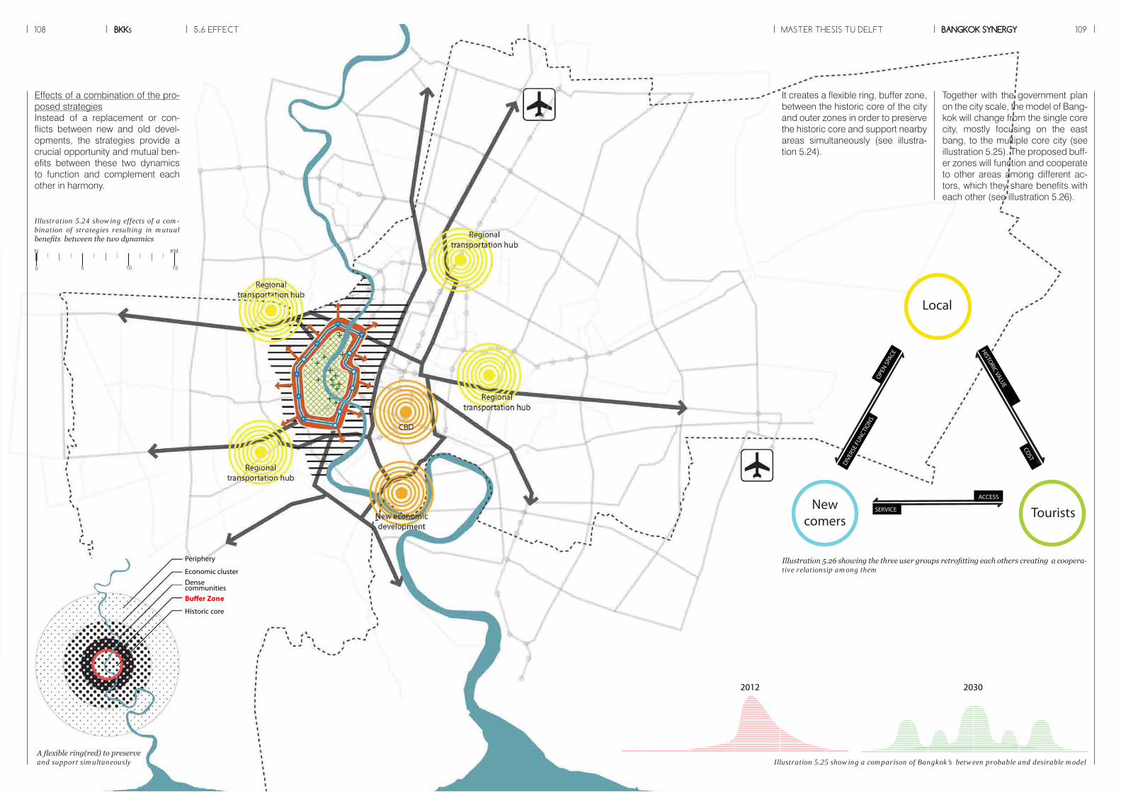
Effects of a combination of the pro-posed strategiesInstead of a replacement or con-flicts between new and old devel-opments, the strategies provide a crucial opportunity and mutual ben-efits between these two dynamics to function and complement each other in harmony.
Together with the government plan on the city scale, the model of Bang-kok will change from the single core city, mostly focusing on the east bang, to the multiple core city (see illustration 5.25). The proposed buff-er zones will function and cooperate to other areas among different ac-tors, which they share benefits with each other (see illustration 5.26).
It creates a flexible ring, buffer zone, between the historic core of the city and outer zones in order to preserve the historic core and support nearby areas simultaneously (see illustra-tion 5.24).
108 BKKs MASTER THESIS TU DELFT BANGKOK SYNERGY 1095.6 EFFECT
Illustration 5.26 showing the three user groups retrofitting each others creating a coopera-tive relationsip among them
Illustration 5.25 showing a comparison of Bangkok’s between probable and desirable model
Periphery
Economic cluster Dense communitiesBuffer Zone
Historic core
A flexible ring(red) to preserve and support simultaneously
Illustration 5.24 showing effects of a com-bination of strategies resulting in mutual benefits between the two dynamics
COST
HISTORIC VALUE
ACCESS
SERVICE
DIVER
SE F
UNCTIO
NSOPE
N SPA
CE
Newcomers
Tourists
Local
20302012
N KM.
0 5 10 15

BKKs110 MASTER THESIS TU DELFT BANGKOK SYNERGY 111
The strategies use different types of existing quality (potential roads, ur-ban void, heritage sites and the area along transit corridor) to revitalize the area. The synergetic vision be-tween the historic core and the MTS has been provided, which integrate these two dynamics by starting with the infrastructure and open space development and then, develop on tourist industries and new mixed functions.
5.7 CONCLUSION
Illustration 5.27 showing an impression of a combination of the strategies
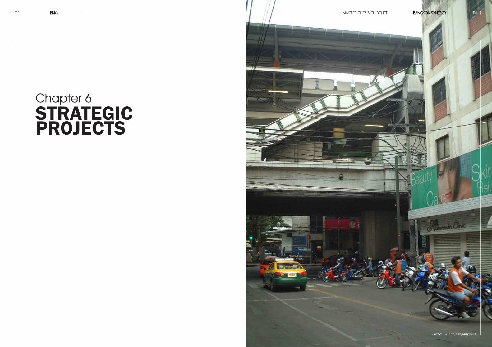
BKKs112
Source : R.Kanjanapanyakom
MASTER THESIS TU DELFT BANGKOK SYNERGY 113
Chapter 6STRATEGICPROJECTS

tion with strategies. Then, four de-sign projects will be selected based on the idea of “from quality to quan-tity” . Finally, the development phas-ing of the project will be unfolded in order to create a better quality of life for people in the process of imple-mentation.
In this part, several samples of strategic design implementation will be mentioned. The solution is not meant to be an end, but rather guidelines of the desirable results of an implementation of the strategic planning on the selected locations. The result may not be the best solu-tion for implementing the strategies integrating the historic core with the MTS, regardless of any conflicts that might rise, such as the claiming of land or the demolition of buildings.The part will start with design inven-tory of possible key projects in rela-
6.1 PROJECTS INVENTORY
Illustration 6.2 showing projects inventory re-garding to the four-mentioned strategies
Illustration 6.1 showing four selections of strategic location as pilot projects.
Illustration 6.3 showing user diagram along ma-jors connections
Tourists
Local residents
New comers
INFRASTRUCTURE OPEN SPACE TOURIST INDUSTRIES URBAN DEVELOPMENT
+ + +
- Cooperate with private developers- Control by policies and bonus systems
- Has an initial role of the process of tranformation in both green and blue networks as same as main-tainance them
- Cooperate with civic sectors in terms of partici-pation and rising aware-ness.- Promote heritage tourism- Subsidize nearby areas
- Cooperate with private sectors to develop areas along transit corridors- Invest in basic needs; a�ordable housing to bring social mix to the area
- bene�t from a chance to invest in service functions which help maintain openspaces
- Bene�t from accessibility to tourist destinations- Channel bene�t back to lacal as �nancial supportand tax to be used as subsidy
- Cooperate with public sectors- Develop towards diversity and density- Provide work and live environment to local
- Cooperate with public sectors- Invest in the infrastructure development and its proximity (transit corridor)
- Bene�t from the improv-ment of mobility and multi modal transport
- Bene�t from accessible openspaces and functions which reduce travel distance- Maintain the cultural landscale
- Work with the state- Strengthen historic values and cultural identity- Bene�t from tourist industries
- Bene�t from diverse typologies and functions- Get a chance to refurbish existing quality- Enhance local economy and social cohesion
Civic sectorsPrivate sectorsPublic sectorsStrategy
Strategies
Slow tra�c
Station area
Global patch
Local patch
Interface
Urban park
Local business
Daily functionsLinear green
Riverside communityBlue network
TOD
Station square
Mobility Landscape Typology Patch
Private transport
Public transport
Mass transit
to MTS
Slow tra�c
Station area
Global patch
Local patch
Interface
Urban park
Local business
Daily functionsLinear green
Riverside communityBlue network
TOD
Station square
Mobility Landscape Typology Patch
Private transport
Public transport
Mass transit
to MTS
Slow tra�c
Station area
Global patch
Local patch
Interface
Urban park
Local business
Daily functionsLinear green
Riverside communityBlue network
TOD
Station square
Mobility Landscape Typology Patch
Private transport
Public transport
Mass transit
to MTS
Slow tra�c
Station area
Global patch
Local patch
Interface
Urban park
Local business
Daily functionsLinear green
Riverside communityBlue network
TOD
Station square
Mobility Landscape Typology Patch
Private transport
Public transport
Mass transit
to MTS
A
D
B
CRIVERSIDE
AREA
PUBLICSPACE
LOCAL STREETS
MTSSTATION LOCAL
SCALE
DISTRICT SCALE
MASTER THESIS TU DELFTBKKs BANGKOK SYNERGY114 115
A : THE STATION AREAB : TRANSFORMED OPEN SPACEC : RIVERSIDE AREASD : LOCAL CONNECTIONS
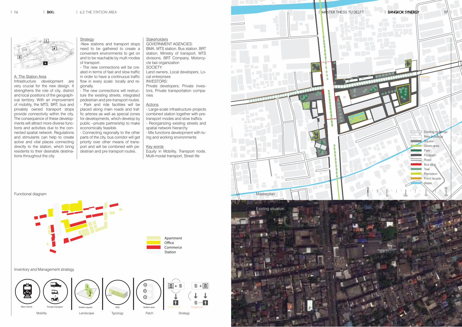
P
P
P
P
Strategy-New stations and transport stops need to be gathered to create a convenient environments to get on and to be reachable by multi modes of transport.- The new connections will be cre-ated in terms of fast and slow traffic in order to have a continuous traffic flow in every scale: locally and re-gionally.- The new connections will restruc-ture the existing streets, integrated pedestrian and pre-transport routes.- Park and ride facilities will be placed along main roads and traf-fic arteries as well as special zones for developments, which develop by public –private partnership to make economically feasible. - Connecting regionally to the other parts of the city, bus corridor will get priority over other means of trans-port and will be combined with pe-destrian and pre transport routes.
StakeholdersGOVERNMENT AGENCIES: BMA, MTS station, Bus station, BRT station, Ministry of transport, MTS divisions, BRT Company, Motorcy-cle taxi organizationSOCIETY: Land owners, Local developers, Lo-cal enterprisesINVESTORS: Private developers, Private inves-tors, Private transportation compa-nies
Actions- Large-scale infrastructure projects combined station together with pre-transport modes and slow traffics- Reorganizing existing streets and spatial network hierarchy- Mix functions development with liv-ing and working environments
Key wordsEquity in Mobility, Transport node, Multi-modal transport, Street life
A: The Station AreaInfrastructure development are very crucial for the new design. It strengthens the role of city, district and local positions of the geograph-ical territory. With an improvement of mobility, the MTS, BRT, bus and privately owned transport stops provide connectivity within the city. The consequence of these develop-ments will attract more diverse func-tions and activities due to the con-nected spatial network. Regulations and stimulants can help to create active and vital places connecting directly to the station, which bring residents to their desirable destina-tions throughout the city.
6.2 THE STATION AREA
INFRASTRUCTURE OPEN SPACE TOURIST INDUSTRIES URBAN DEVELOPMENT
+ + +
- Cooperate with private developers- Control by policies and bonus systems
- Has an initial role of the process of tranformation in both green and blue networks as same as main-tainance them
- Cooperate with civic sectors in terms of partici-pation and rising aware-ness.- Promote heritage tourism- Subsidize nearby areas
- Cooperate with private sectors to develop areas along transit corridors- Invest in basic needs; a�ordable housing to bring social mix to the area
- bene�t from a chance to invest in service functions which help maintain openspaces
- Bene�t from accessibility to tourist destinations- Channel bene�t back to lacal as �nancial supportand tax to be used as subsidy
- Cooperate with public sectors- Develop towards diversity and density- Provide work and live environment to local
- Cooperate with public sectors- Invest in the infrastructure development and its proximity (transit corridor)
- Bene�t from the improv-ment of mobility and multi modal transport
- Bene�t from accessible openspaces and functions which reduce travel distance- Maintain the cultural landscale
- Work with the state- Strengthen historic values and cultural identity- Bene�t from tourist industries
- Bene�t from diverse typologies and functions- Get a chance to refurbish existing quality- Enhance local economy and social cohesion
Civic sectorsPrivate sectorsPublic sectorsStrategy
Slow tra�c
Station area
Global patch
Local patch
Interface
Urban park
Local business
Daily functionsLinear green
Riverside communityBlue network
TOD
Station square
Mobility Landscape Typology Patch
Private transport
Public transport
Mass transit
to MTS
Slow tra�c
Station area
Global patch
Local patch
Interface
Urban park
Local business
Daily functionsLinear green
Riverside communityBlue network
TOD
Station square
Mobility Landscape Typology Patch
Private transport
Public transport
Mass transit
to MTS
Slow tra�c
Station area
Global patch
Local patch
Interface
Urban park
Local business
Daily functionsLinear green
Riverside communityBlue network
TOD
Station square
Mobility Landscape Typology Patch
Private transport
Public transport
Mass transit
to MTS
Slow tra�c
Station area
Global patch
Local patch
Interface
Urban park
Local business
Daily functionsLinear green
Riverside communityBlue network
TOD
Station square
Mobility Landscape Typology Patch
Private transport
Public transport
Mass transit
to MTS
Slow tra�c
Station area
Global patch
Local patch
Interface
Urban park
Local business
Daily functionsLinear green
Riverside communityBlue network
TOD
Station square
Mobility Landscape Typology Patch
Private transport
Public transport
Mass transit
to MTS
Mobility Landscape Typology Patch Strategy
Infrastructure Programme
Existing buildings
New buildings
Square
Green area
Park
Footpath
Road
Bus stop
Tree
Plantation
Front facade
Water
ApartmentCommerceServiceInfo.Tea houseLibraryCommunity centreGated communitySportSocial housing
ResidenceApartmentO�ceCommerceServiceTea houseGovernment o�ceTemplePierSchool
ResidenceApartmentO�ceCommerceGovernment o�ceSchoolBank
ApartmentO�ceCommerceStation
ApartmentCommerceServiceInfo.Tea houseLibraryCommunity centreGated communitySportSocial housing
ResidenceApartmentO�ceCommerceServiceTea houseGovernment o�ceTemplePierSchool
ResidenceApartmentO�ceCommerceGovernment o�ceSchoolBank
ApartmentO�ceCommerceStation
MASTER THESIS TU DELFT BANGKOK SYNERGY 117MASTER THESIS TU DELFTBKKs BANGKOK SYNERGY116 117
Functional diagram Masterplan
Existing situation
Inventory and Management strategy
A
D
B
C
A
M.N
150 2000 50 100
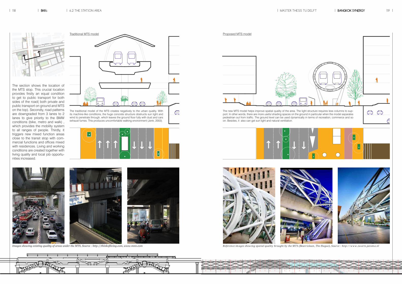
P
P
The section shows the location of the MTS stop. This crucial location provides firstly an equal condition to get to public transport for both sides of the road( both private and public transport on ground and MTS on the top). Secondly, road patterns are downgraded from 3 lanes to 2 lanes to give priority to the BMW conditions (bike, metro and walk) , which provides the mobility system to all ranges of people. Thirdly, it triggers new mixed function areas close to the transit stop with com-mercial functions and offices mixed with residences. Living and working conditions are created together with living quality and local job opportu-nities increased.
The new MTS model helps improve spatial quality of the area. The light structure requires less columns to sup-port. In other words, there are more useful shading spaces on the ground in particular when the model separates pedestrian out from traffic. The ground level can be used dynamically in terms of recreation, commerce and so on. Besides, it also can get sun light and natural ventilation.
The traditional model of the MTS creates negatively to the urban quality. With its machine-like conditions, the huge concrete structure obstructs sun light and wind to penetrate through, which leaves the ground floor fully with dust and cars exhaust fumes. This produces uncomfortable walking environment (Jenk, 2003).
Traditional MTS model Proposed MTS model
6.2 THE STATION AREA MASTER THESIS TU DELFTBKKs BANGKOK SYNERGY118 119
Reference images showing spatial quality brought by the MTS (Beatrixlaan, The Hague), Source : http://www.zwarts.jansma.nlImages showing existing quality of areas under the MTS, Source : http://thinkofliving.com, www.mnn.com
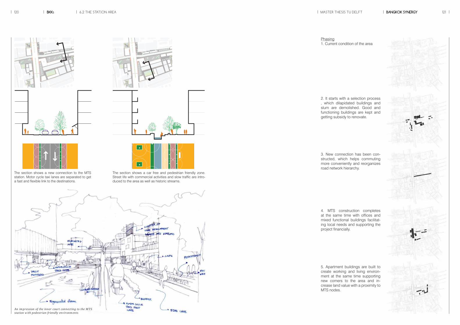
6.2 THE STATION AREA MASTER THESIS TU DELFTBKKs BANGKOK SYNERGY120 121
P
P
The section shows a new connection to the MTS station. Motor cycle taxi lanes are separated to get a fast and flexible link to the destinations.
P
P
The section shows a car free and pedestrian friendly zone. Street life with commercial activities and slow traffic are intro-duced to the area as well as historic streams.
Phasing1. Current condition of the area
2. It starts with a selection process , which dilapidated buildings and slum are demolished. Good and functioning buildings are kept and getting subsidy to renovate.
3. New connection has been con-structed, which helps commuting more conveniently and reorganizes road network hierarchy.
4. MTS construction completes at the same time with offices and mixed functional buildings facilitat-ing local needs and supporting the project financially.
5. Apartment buildings are built to create working and living environ-ment at the same time supporting new comers to the area and in-crease land value with a proximity to MTS nodes.
An impression of the inner court connecting to the MTS station with pedestrian friendly environments

An impression shows the new develop-ments along traffic arteries with mixed functions by using TOD concepts
Isometric showing the new development areas adjacent to the transit stop (new buildings are colored in white)
The captures of the movie showing se-quences of activities in the area.
Full movie is available online at: http://youtu.be/ldDTd0QgUsc
6.2 THE STATION AREA MASTER THESIS TU DELFTBKKs BANGKOK SYNERGY122 123
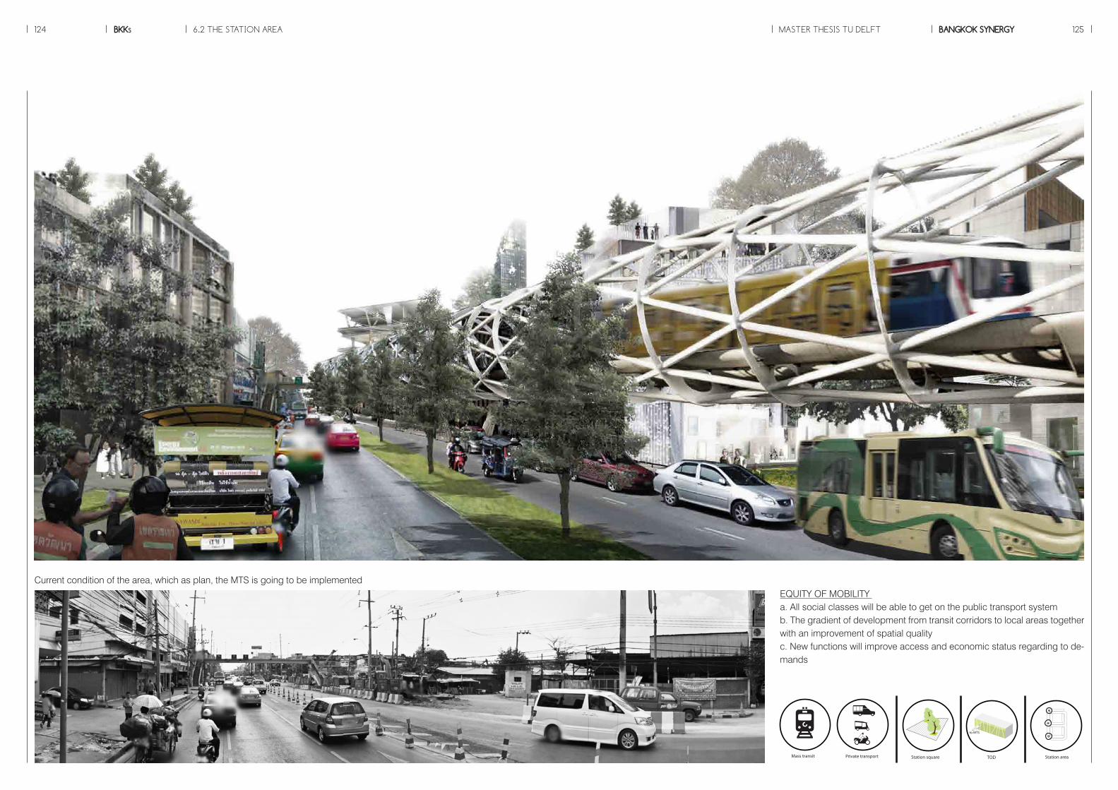
6.2 THE STATION AREA MASTER THESIS TU DELFTBKKs BANGKOK SYNERGY124 125
Current condition of the area, which as plan, the MTS is going to be implementedEQUITY OF MOBILITY a. All social classes will be able to get on the public transport systemb. The gradient of development from transit corridors to local areas together with an improvement of spatial qualityc. New functions will improve access and economic status regarding to de-mands
Slow tra�c
Station area
Global patch
Local patch
Interface
Urban park
Local business
Daily functionsLinear green
Riverside communityBlue network
TOD
Station square
Mobility Landscape Typology Patch
Private transport
Public transport
Mass transit
to MTS
Slow tra�c
Station area
Global patch
Local patch
Interface
Urban park
Local business
Daily functionsLinear green
Riverside communityBlue network
TOD
Station square
Mobility Landscape Typology Patch
Private transport
Public transport
Mass transit
to MTS
Slow tra�c
Station area
Global patch
Local patch
Interface
Urban park
Local business
Daily functionsLinear green
Riverside communityBlue network
TOD
Station square
Mobility Landscape Typology Patch
Private transport
Public transport
Mass transit
to MTS
Slow tra�c
Station area
Global patch
Local patch
Interface
Urban park
Local business
Daily functionsLinear green
Riverside communityBlue network
TOD
Station square
Mobility Landscape Typology Patch
Private transport
Public transport
Mass transit
to MTS
Slow tra�c
Station area
Global patch
Local patch
Interface
Urban park
Local business
Daily functionsLinear green
Riverside communityBlue network
TOD
Station square
Mobility Landscape Typology Patch
Private transport
Public transport
Mass transit
to MTS
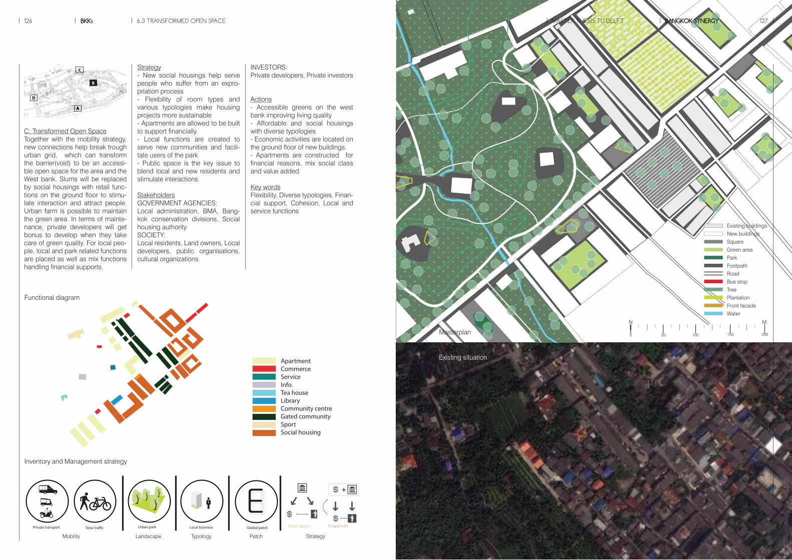
Slow tra�c
Station area
Global patch
Local patch
Interface
Urban park
Local business
Daily functionsLinear green
Riverside communityBlue network
TOD
Station square
Mobility Landscape Typology Patch
Private transport
Public transport
Mass transit
to MTS
Slow tra�c
Station area
Global patch
Local patch
Interface
Urban park
Local business
Daily functionsLinear green
Riverside communityBlue network
TOD
Station square
Mobility Landscape Typology Patch
Private transport
Public transport
Mass transit
to MTS
Slow tra�c
Station area
Global patch
Local patch
Interface
Urban park
Local business
Daily functionsLinear green
Riverside communityBlue network
TOD
Station square
Mobility Landscape Typology Patch
Private transport
Public transport
Mass transit
to MTS
Slow tra�c
Station area
Global patch
Local patch
Interface
Urban park
Local business
Daily functionsLinear green
Riverside communityBlue network
TOD
Station square
Mobility Landscape Typology Patch
Private transport
Public transport
Mass transit
to MTS
Slow tra�c
Station area
Global patch
Local patch
Interface
Urban park
Local business
Daily functionsLinear green
Riverside communityBlue network
TOD
Station square
Mobility Landscape Typology Patch
Private transport
Public transport
Mass transit
to MTS
ApartmentCommerceServiceInfo.Tea houseLibraryCommunity centreGated communitySportSocial housing
ResidenceApartmentO�ceCommerceServiceTea houseGovernment o�ceTemplePierSchool
ResidenceApartmentO�ceCommerceGovernment o�ceSchoolBank
ApartmentO�ceCommerceStation
6.3 TRANSFORMED OPEN SPACE MASTER THESIS TU DELFTBKKs BANGKOK SYNERGY126 127
A
B
C
D
A
Strategy- New social housings help serve people who suffer from an expro-priation process- Flexibility of room types and various typologies make housing projects more sustainable- Apartments are allowed to be built to support financially.- Local functions are created to serve new communities and facili-tate users of the park- Public space is the key issue to blend local and new residents and stimulate interactions
StakeholdersGOVERNMENT AGENCIES: Local administration, BMA, Bang-kok conservation divisions, Social housing authoritySOCIETY: Local residents, Land owners, Local developers, public organisations, cultural organizations
INVESTORS: Private developers, Private investors
Actions- Accessible greens on the west bank improving living quality- Affordable and social housings with diverse typologies - Economic activities are located on the ground floor of new buildings.- Apartments are constructed for financial reasons, mix social class and value added. Key wordsFlexibility, Diverse typologies, Finan-cial support, Cohesion, Local and service functions
C: Transformed Open SpaceTogether with the mobility strategy, new connections help break trough urban grid, which can transform the barrier(void) to be an accessi-ble open space for the area and the West bank. Slums will be replaced by social housings with retail func-tions on the ground floor to stimu-late interaction and attract people. Urban farm is possible to maintain the green area. In terms of mainte-nance, private developers will get bonus to develop when they take care of green quality. For local peo-ple, local and park related functions are placed as well as mix functions handling financial supports.
INFRASTRUCTURE OPEN SPACE TOURIST INDUSTRIES URBAN DEVELOPMENT
+ + +
- Cooperate with private developers- Control by policies and bonus systems
- Has an initial role of the process of tranformation in both green and blue networks as same as main-tainance them
- Cooperate with civic sectors in terms of partici-pation and rising aware-ness.- Promote heritage tourism- Subsidize nearby areas
- Cooperate with private sectors to develop areas along transit corridors- Invest in basic needs; a�ordable housing to bring social mix to the area
- bene�t from a chance to invest in service functions which help maintain openspaces
- Bene�t from accessibility to tourist destinations- Channel bene�t back to lacal as �nancial supportand tax to be used as subsidy
- Cooperate with public sectors- Develop towards diversity and density- Provide work and live environment to local
- Cooperate with public sectors- Invest in the infrastructure development and its proximity (transit corridor)
- Bene�t from the improv-ment of mobility and multi modal transport
- Bene�t from accessible openspaces and functions which reduce travel distance- Maintain the cultural landscale
- Work with the state- Strengthen historic values and cultural identity- Bene�t from tourist industries
- Bene�t from diverse typologies and functions- Get a chance to refurbish existing quality- Enhance local economy and social cohesion
Civic sectorsPrivate sectorsPublic sectorsStrategy
Open space Programme
ApartmentCommerceServiceInfo.Tea houseLibraryCommunity centreGated communitySportSocial housing
ResidenceApartmentO�ceCommerceServiceTea houseGovernment o�ceTemplePierSchool
ResidenceApartmentO�ceCommerceGovernment o�ceSchoolBank
ApartmentO�ceCommerceStation
M.N
150 2000 50 100
Functional diagram
Masterplan
Existing situation
Inventory and Management strategy
Mobility Landscape Typology Patch Strategy
Existing buildings
New buildings
Square
Green area
Park
Footpath
Road
Bus stop
Tree
Plantation
Front facade
Water
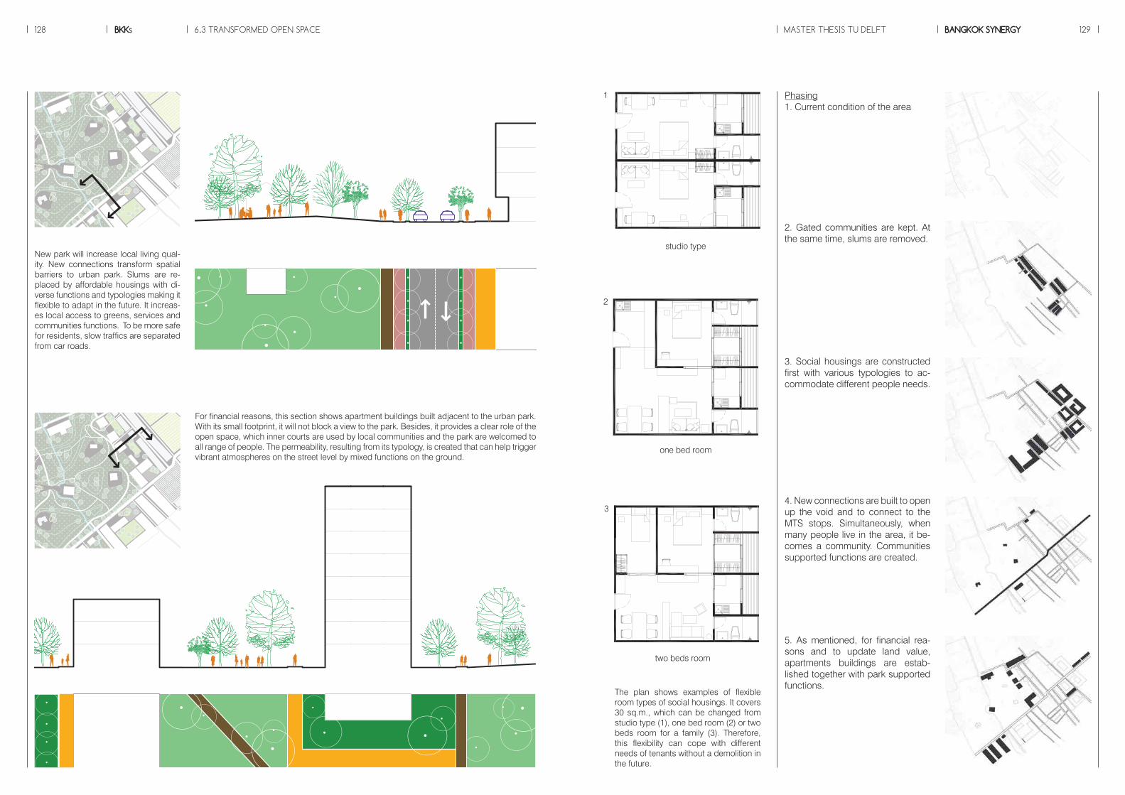
6.3 TRANSFORMED OPEN SPACE MASTER THESIS TU DELFTBKKs BANGKOK SYNERGY128 129
New park will increase local living qual-ity. New connections transform spatial barriers to urban park. Slums are re-placed by affordable housings with di-verse functions and typologies making it flexible to adapt in the future. It increas-es local access to greens, services and communities functions. To be more safe for residents, slow traffics are separated from car roads.
For financial reasons, this section shows apartment buildings built adjacent to the urban park. With its small footprint, it will not block a view to the park. Besides, it provides a clear role of the open space, which inner courts are used by local communities and the park are welcomed to all range of people. The permeability, resulting from its typology, is created that can help trigger vibrant atmospheres on the street level by mixed functions on the ground.
Phasing1. Current condition of the area
2. Gated communities are kept. At the same time, slums are removed.
3. Social housings are constructed first with various typologies to ac-commodate different people needs.
4. New connections are built to open up the void and to connect to the MTS stops. Simultaneously, when many people live in the area, it be-comes a community. Communities supported functions are created.
5. As mentioned, for financial rea-sons and to update land value, apartments buildings are estab-lished together with park supported functions.
The plan shows examples of flexible room types of social housings. It covers 30 sq.m., which can be changed from studio type (1), one bed room (2) or two beds room for a family (3). Therefore, this flexibility can cope with different needs of tenants without a demolition in the future.
1
2
3
studio type
one bed room
two beds room

An impression of the accessible urban parks with diverse activities
6.3 TRANSFORMED OPEN SPACE MASTER THESIS TU DELFTBKKs BANGKOK SYNERGY130 131
The captures of the movie showing se-quences of activities in the area.
Full movie is available online at: http://youtu.be/BjB0V8oHwuo
Isometric showing different sizes and fun-tions of public space shared with local resi-dents and new comers (new buildings are colored in white).

6.3 TRANSFORMED OPEN SPACE MASTER THESIS TU DELFTBKKs BANGKOK SYNERGY132 133
SOCIAL COHESIONa. Accessible green spaces particularly to the Westb. Public spaces stimulate social interactionc. Proposed building typologies are designed aiming to blend new comers and local residents together by sharing the same social position
Slow tra�c
Station area
Global patch
Local patch
Interface
Urban park
Local business
Daily functionsLinear green
Riverside communityBlue network
TOD
Station square
Mobility Landscape Typology Patch
Private transport
Public transport
Mass transit
to MTS
Slow tra�c
Station area
Global patch
Local patch
Interface
Urban park
Local business
Daily functionsLinear green
Riverside communityBlue network
TOD
Station square
Mobility Landscape Typology Patch
Private transport
Public transport
Mass transit
to MTS
Slow tra�c
Station area
Global patch
Local patch
Interface
Urban park
Local business
Daily functionsLinear green
Riverside communityBlue network
TOD
Station square
Mobility Landscape Typology Patch
Private transport
Public transport
Mass transit
to MTS
Slow tra�c
Station area
Global patch
Local patch
Interface
Urban park
Local business
Daily functionsLinear green
Riverside communityBlue network
TOD
Station square
Mobility Landscape Typology Patch
Private transport
Public transport
Mass transit
to MTS
Slow tra�c
Station area
Global patch
Local patch
Interface
Urban park
Local business
Daily functionsLinear green
Riverside communityBlue network
TOD
Station square
Mobility Landscape Typology Patch
Private transport
Public transport
Mass transit
to MTS
Current condition of the spatial barriers
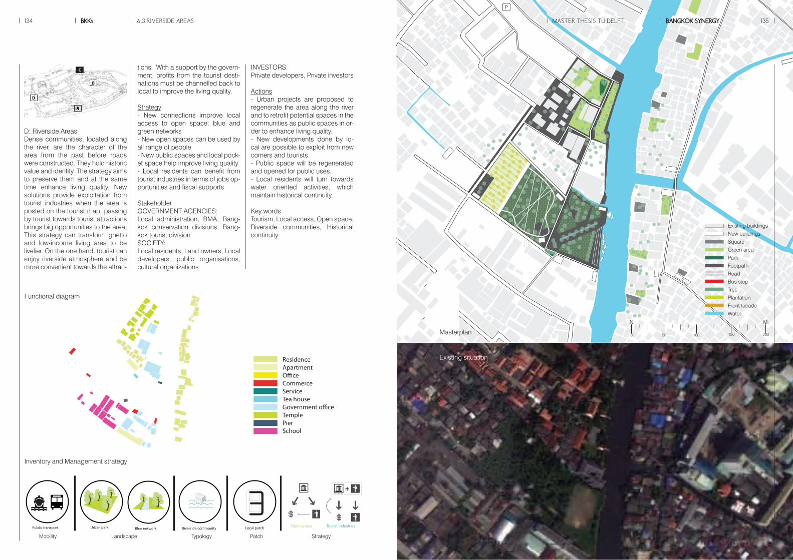
P
P
6.3 RIVERSIDE AREAS MASTER THESIS TU DELFTBKKs BANGKOK SYNERGY134 135
tions. With a support by the govern-ment, profits from the tourist desti-nations must be channelled back to local to improve the living quality.
Strategy- New connections improve local access to open space; blue and green networks- New open spaces can be used by all range of people- New public spaces and local pock-et space help improve living quality- Local residents can benefit from tourist industries in terms of jobs op-portunities and fiscal supports StakeholderGOVERNMENT AGENCIES: Local administration, BMA, Bang-kok conservation divisions, Bang-kok tourist divisionSOCIETY: Local residents, Land owners, Local developers, public organisations, cultural organizations
INVESTORS: Private developers, Private investors
Actions- Urban projects are proposed to regenerate the area along the river and to retrofit potential spaces in the communities as public spaces in or-der to enhance living quality.- New developments done by lo-cal are possible to exploit from new comers and tourists. - Public space will be regenerated and opened for public uses.- Local residents will turn towards water oriented activities, which maintain historical continuity.
Key wordsTourism, Local access, Open space, Riverside communities, Historical continuity
D: Riverside AreasDense communities, located along the river, are the character of the area from the past before roads were constructed. They hold historic value and identity. The strategy aims to preserve them and at the same time enhance living quality. New solutions provide exploitation from tourist industries when the area is posted on the tourist map, passing by tourist towards tourist attractions brings big opportunities to the area. This strategy can transform ghetto and low-income living area to be livelier. On the one hand, tourist can enjoy riverside atmosphere and be more convenient towards the attrac-
INFRASTRUCTURE OPEN SPACE TOURIST INDUSTRIES URBAN DEVELOPMENT
+ + +
- Cooperate with private developers- Control by policies and bonus systems
- Has an initial role of the process of tranformation in both green and blue networks as same as main-tainance them
- Cooperate with civic sectors in terms of partici-pation and rising aware-ness.- Promote heritage tourism- Subsidize nearby areas
- Cooperate with private sectors to develop areas along transit corridors- Invest in basic needs; a�ordable housing to bring social mix to the area
- bene�t from a chance to invest in service functions which help maintain openspaces
- Bene�t from accessibility to tourist destinations- Channel bene�t back to lacal as �nancial supportand tax to be used as subsidy
- Cooperate with public sectors- Develop towards diversity and density- Provide work and live environment to local
- Cooperate with public sectors- Invest in the infrastructure development and its proximity (transit corridor)
- Bene�t from the improv-ment of mobility and multi modal transport
- Bene�t from accessible openspaces and functions which reduce travel distance- Maintain the cultural landscale
- Work with the state- Strengthen historic values and cultural identity- Bene�t from tourist industries
- Bene�t from diverse typologies and functions- Get a chance to refurbish existing quality- Enhance local economy and social cohesion
Civic sectorsPrivate sectorsPublic sectorsStrategy
Mobility Landscape Typology Patch Strategy
Open space Tourist industries
ApartmentCommerceServiceInfo.Tea houseLibraryCommunity centreGated communitySportSocial housing
ResidenceApartmentO�ceCommerceServiceTea houseGovernment o�ceTemplePierSchool
ResidenceApartmentO�ceCommerceGovernment o�ceSchoolBank
ApartmentO�ceCommerceStation
Functional diagram
Masterplan
Existing situation
Inventory and Management strategy
A
D
B
C
A
Slow tra�c
Station area
Global patch
Local patch
Interface
Urban park
Local business
Daily functionsLinear green
Riverside communityBlue network
TOD
Station square
Mobility Landscape Typology Patch
Private transport
Public transport
Mass transit
to MTS
Slow tra�c
Station area
Global patch
Local patch
Interface
Urban park
Local business
Daily functionsLinear green
Riverside communityBlue network
TOD
Station square
Mobility Landscape Typology Patch
Private transport
Public transport
Mass transit
to MTS
Slow tra�c
Station area
Global patch
Local patch
Interface
Urban park
Local business
Daily functionsLinear green
Riverside communityBlue network
TOD
Station square
Mobility Landscape Typology Patch
Private transport
Public transport
Mass transit
to MTS
Slow tra�c
Station area
Global patch
Local patch
Interface
Urban park
Local business
Daily functionsLinear green
Riverside communityBlue network
TOD
Station square
Mobility Landscape Typology Patch
Private transport
Public transport
Mass transit
to MTS
Slow tra�c
Station area
Global patch
Local patch
Interface
Urban park
Local business
Daily functionsLinear green
Riverside communityBlue network
TOD
Station square
Mobility Landscape Typology Patch
Private transport
Public transport
Mass transit
to MTS
ApartmentCommerceServiceInfo.Tea houseLibraryCommunity centreGated communitySportSocial housing
ResidenceApartmentO�ceCommerceServiceTea houseGovernment o�ceTemplePierSchool
ResidenceApartmentO�ceCommerceGovernment o�ceSchoolBank
ApartmentO�ceCommerceStation
Existing buildings
New buildings
Square
Green area
Park
Footpath
Road
Bus stop
Tree
Plantation
Front facade
Water
M.N
150 2000 50 100
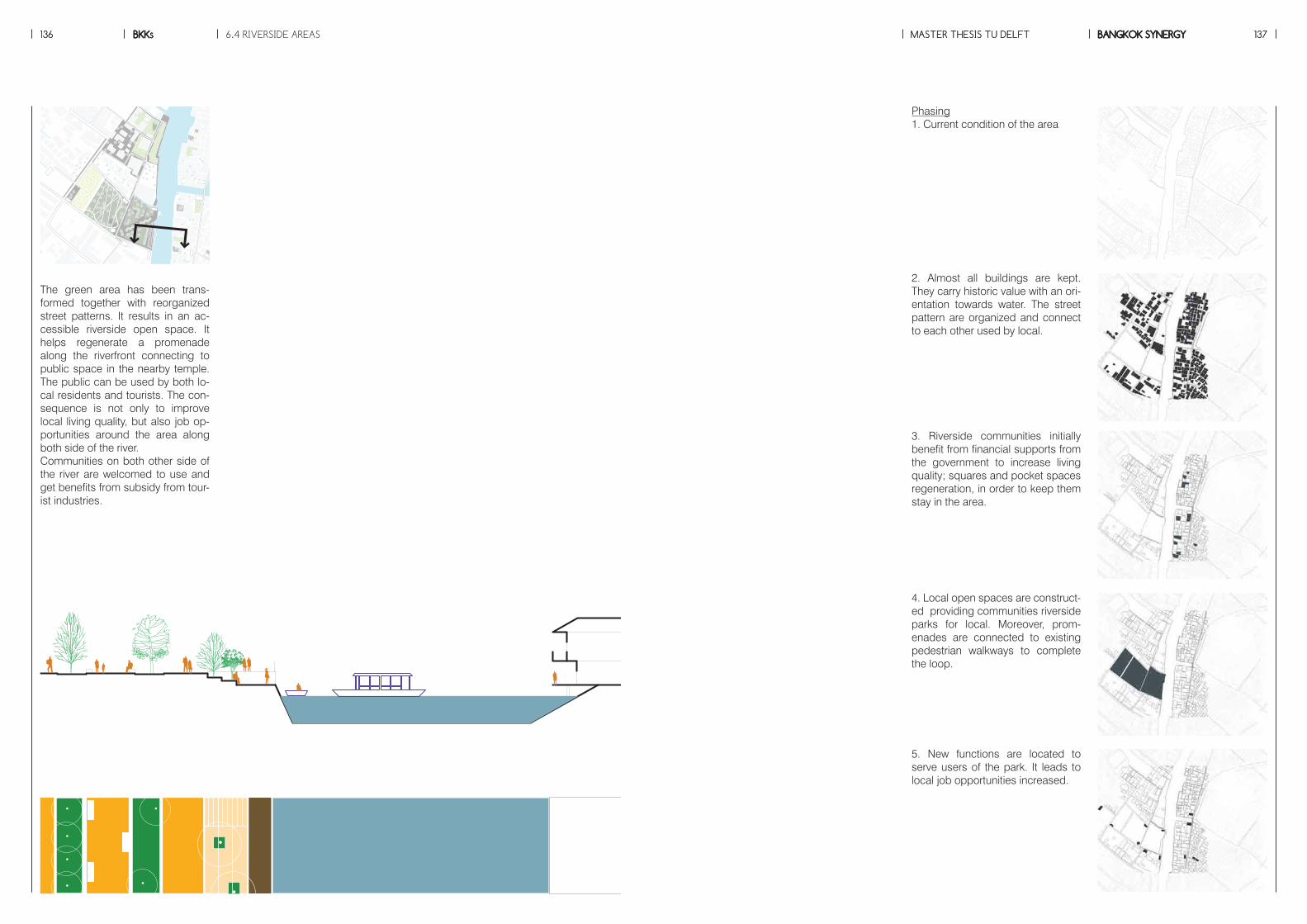
6.4 RIVERSIDE AREAS MASTER THESIS TU DELFTBKKs BANGKOK SYNERGY136 137MASTER THESIS TU DELFTBKKs BANGKOK SYNERGY136 137
The green area has been trans-formed together with reorganized street patterns. It results in an ac-cessible riverside open space. It helps regenerate a promenade along the riverfront connecting to public space in the nearby temple. The public can be used by both lo-cal residents and tourists. The con-sequence is not only to improve local living quality, but also job op-portunities around the area along both side of the river.Communities on both other side of the river are welcomed to use and get benefits from subsidy from tour-ist industries.
Phasing1. Current condition of the area
2. Almost all buildings are kept. They carry historic value with an ori-entation towards water. The street pattern are organized and connect to each other used by local.
3. Riverside communities initially benefit from financial supports from the government to increase living quality; squares and pocket spaces regeneration, in order to keep them stay in the area.
4. Local open spaces are construct-ed providing communities riverside parks for local. Moreover, prom-enades are connected to existing pedestrian walkways to complete the loop.
5. New functions are located to serve users of the park. It leads to local job opportunities increased.
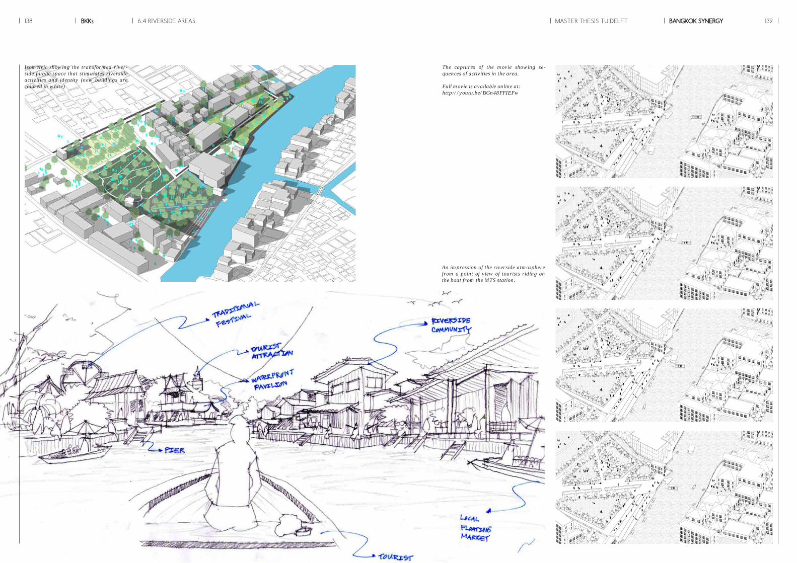
6.4 RIVERSIDE AREAS MASTER THESIS TU DELFTBKKs BANGKOK SYNERGY138 139
Isometric showing the transformed river-side public space that stimulates riverside activities and identity (new buildings are colored in white)
An impression of the riverside atmosphere from a point of view of tourists riding on the boat from the MTS station.
The captures of the movie showing se-quences of activities in the area.
Full movie is available online at: http://youtu.be/BGn48FFIEFw
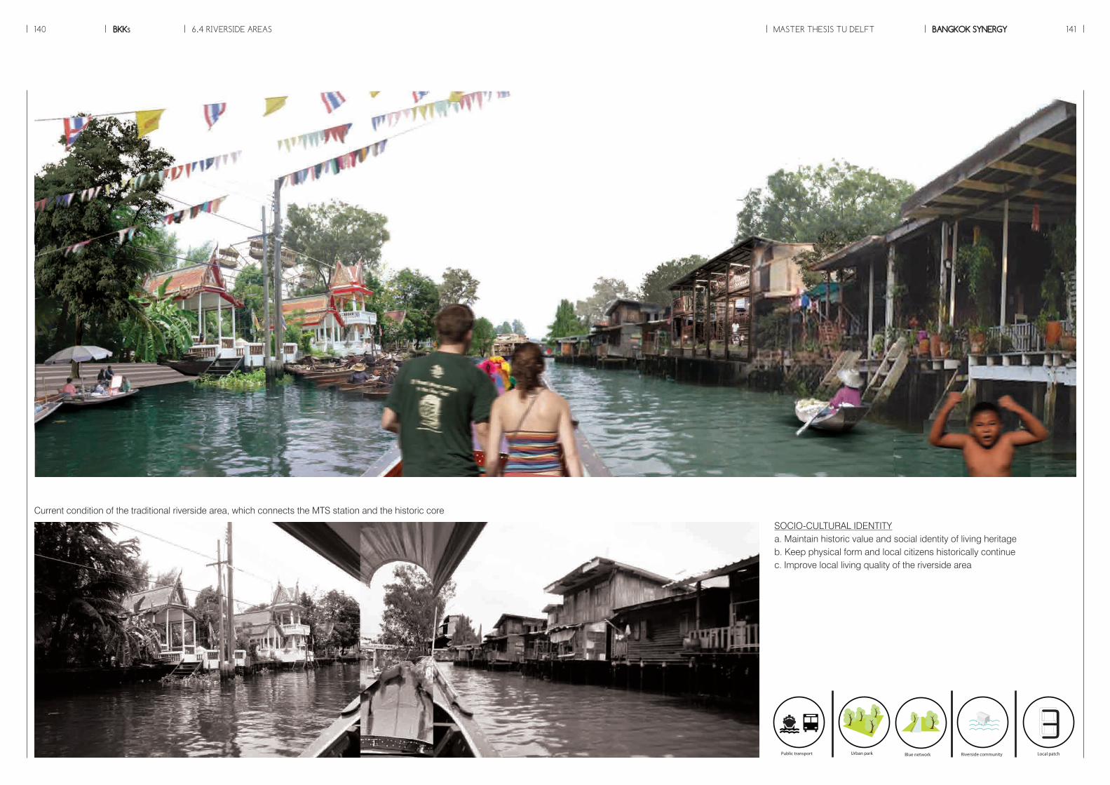
6.4 RIVERSIDE AREAS MASTER THESIS TU DELFTBKKs BANGKOK SYNERGY140 141
SOCIO-CULTURAL IDENTITYa. Maintain historic value and social identity of living heritage b. Keep physical form and local citizens historically continuec. Improve local living quality of the riverside area
Slow tra�c
Station area
Global patch
Local patch
Interface
Urban park
Local business
Daily functionsLinear green
Riverside communityBlue network
TOD
Station square
Mobility Landscape Typology Patch
Private transport
Public transport
Mass transit
to MTS
Slow tra�c
Station area
Global patch
Local patch
Interface
Urban park
Local business
Daily functionsLinear green
Riverside communityBlue network
TOD
Station square
Mobility Landscape Typology Patch
Private transport
Public transport
Mass transit
to MTS
Slow tra�c
Station area
Global patch
Local patch
Interface
Urban park
Local business
Daily functionsLinear green
Riverside communityBlue network
TOD
Station square
Mobility Landscape Typology Patch
Private transport
Public transport
Mass transit
to MTS
Slow tra�c
Station area
Global patch
Local patch
Interface
Urban park
Local business
Daily functionsLinear green
Riverside communityBlue network
TOD
Station square
Mobility Landscape Typology Patch
Private transport
Public transport
Mass transit
to MTS
Slow tra�c
Station area
Global patch
Local patch
Interface
Urban park
Local business
Daily functionsLinear green
Riverside communityBlue network
TOD
Station square
Mobility Landscape Typology Patch
Private transport
Public transport
Mass transit
to MTS
Current condition of the traditional riverside area, which connects the MTS station and the historic core
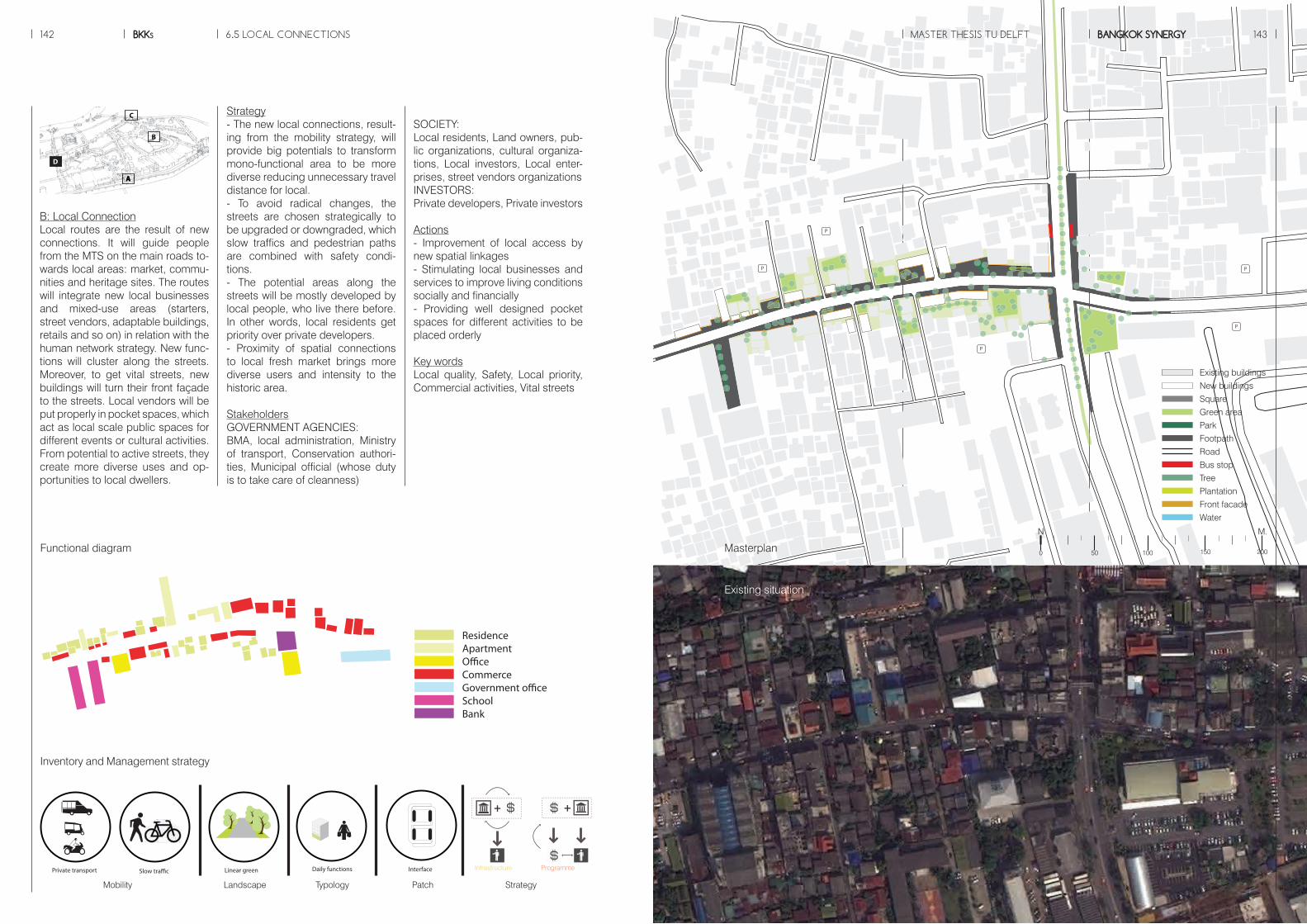
P
P
P
PP
P
P
P
PP
6.5 LOCAL CONNECTIONS MASTER THESIS TU DELFTBKKs BANGKOK SYNERGY142 143
A
B
C
D
A
Strategy- The new local connections, result-ing from the mobility strategy, will provide big potentials to transform mono-functional area to be more diverse reducing unnecessary travel distance for local.- To avoid radical changes, the streets are chosen strategically to be upgraded or downgraded, which slow traffics and pedestrian paths are combined with safety condi-tions.- The potential areas along the streets will be mostly developed by local people, who live there before. In other words, local residents get priority over private developers.- Proximity of spatial connections to local fresh market brings more diverse users and intensity to the historic area.
StakeholdersGOVERNMENT AGENCIES: BMA, local administration, Ministry of transport, Conservation authori-ties, Municipal official (whose duty is to take care of cleanness)
SOCIETY: Local residents, Land owners, pub-lic organizations, cultural organiza-tions, Local investors, Local enter-prises, street vendors organizationsINVESTORS: Private developers, Private investors
Actions- Improvement of local access by new spatial linkages- Stimulating local businesses and services to improve living conditions socially and financially- Providing well designed pocket spaces for different activities to be placed orderly
Key wordsLocal quality, Safety, Local priority, Commercial activities, Vital streets
B: Local ConnectionLocal routes are the result of new connections. It will guide people from the MTS on the main roads to-wards local areas: market, commu-nities and heritage sites. The routes will integrate new local businesses and mixed-use areas (starters, street vendors, adaptable buildings, retails and so on) in relation with the human network strategy. New func-tions will cluster along the streets. Moreover, to get vital streets, new buildings will turn their front façade to the streets. Local vendors will be put properly in pocket spaces, which act as local scale public spaces for different events or cultural activities. From potential to active streets, they create more diverse uses and op-portunities to local dwellers.
INFRASTRUCTURE OPEN SPACE TOURIST INDUSTRIES URBAN DEVELOPMENT
+ + +
- Cooperate with private developers- Control by policies and bonus systems
- Has an initial role of the process of tranformation in both green and blue networks as same as main-tainance them
- Cooperate with civic sectors in terms of partici-pation and rising aware-ness.- Promote heritage tourism- Subsidize nearby areas
- Cooperate with private sectors to develop areas along transit corridors- Invest in basic needs; a�ordable housing to bring social mix to the area
- bene�t from a chance to invest in service functions which help maintain openspaces
- Bene�t from accessibility to tourist destinations- Channel bene�t back to lacal as �nancial supportand tax to be used as subsidy
- Cooperate with public sectors- Develop towards diversity and density- Provide work and live environment to local
- Cooperate with public sectors- Invest in the infrastructure development and its proximity (transit corridor)
- Bene�t from the improv-ment of mobility and multi modal transport
- Bene�t from accessible openspaces and functions which reduce travel distance- Maintain the cultural landscale
- Work with the state- Strengthen historic values and cultural identity- Bene�t from tourist industries
- Bene�t from diverse typologies and functions- Get a chance to refurbish existing quality- Enhance local economy and social cohesion
Civic sectorsPrivate sectorsPublic sectorsStrategy
Mobility Landscape Typology Patch Strategy
Infrastructure Programme
ApartmentCommerceServiceInfo.Tea houseLibraryCommunity centreGated communitySportSocial housing
ResidenceApartmentO�ceCommerceServiceTea houseGovernment o�ceTemplePierSchool
ResidenceApartmentO�ceCommerceGovernment o�ceSchoolBank
ApartmentO�ceCommerceStation
ApartmentCommerceServiceInfo.Tea houseLibraryCommunity centreGated communitySportSocial housing
ResidenceApartmentO�ceCommerceServiceTea houseGovernment o�ceTemplePierSchool
ResidenceApartmentO�ceCommerceGovernment o�ceSchoolBank
ApartmentO�ceCommerceStation
M.N
150 2000 50 100Functional diagram Masterplan
Existing situation
Inventory and Management strategy
Slow tra�c
Station area
Global patch
Local patch
Interface
Urban park
Local business
Daily functionsLinear green
Riverside communityBlue network
TOD
Station square
Mobility Landscape Typology Patch
Private transport
Public transport
Mass transit
to MTS
Slow tra�c
Station area
Global patch
Local patch
Interface
Urban park
Local business
Daily functionsLinear green
Riverside communityBlue network
TOD
Station square
Mobility Landscape Typology Patch
Private transport
Public transport
Mass transit
to MTS
Slow tra�c
Station area
Global patch
Local patch
Interface
Urban park
Local business
Daily functionsLinear green
Riverside communityBlue network
TOD
Station square
Mobility Landscape Typology Patch
Private transport
Public transport
Mass transit
to MTS
Slow tra�c
Station area
Global patch
Local patch
Interface
Urban park
Local business
Daily functionsLinear green
Riverside communityBlue network
TOD
Station square
Mobility Landscape Typology Patch
Private transport
Public transport
Mass transit
to MTS
Slow tra�c
Station area
Global patch
Local patch
Interface
Urban park
Local business
Daily functionsLinear green
Riverside communityBlue network
TOD
Station square
Mobility Landscape Typology Patch
Private transport
Public transport
Mass transit
to MTS
Existing buildings
New buildings
Square
Green area
Park
Footpath
Road
Bus stop
Tree
Plantation
Front facade
Water
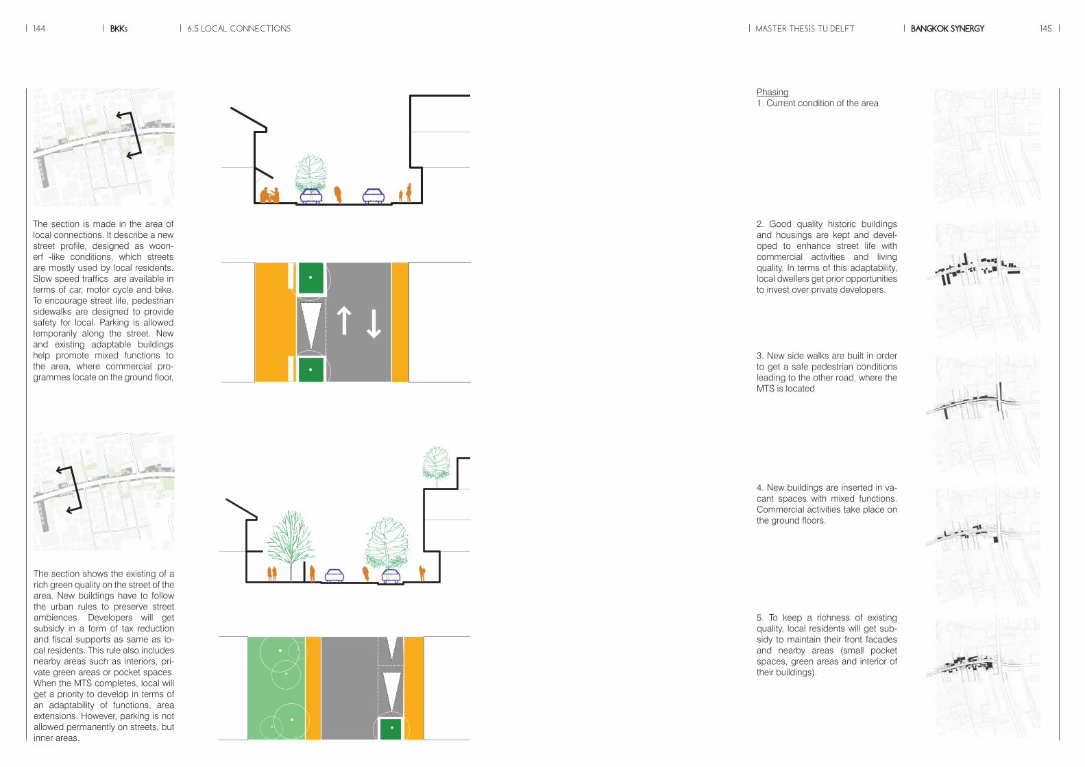
P
P
P
6.5 LOCAL CONNECTIONS MASTER THESIS TU DELFTBKKs BANGKOK SYNERGY144 145
The section is made in the area of local connections. It describe a new street profile, designed as woon-erf -like conditions, which streets are mostly used by local residents. Slow speed traffics are available in terms of car, motor cycle and bike. To encourage street life, pedestrian sidewalks are designed to provide safety for local. Parking is allowed temporarily along the street. New and existing adaptable buildings help promote mixed functions to the area, where commercial pro-grammes locate on the ground floor.
Phasing1. Current condition of the area
2. Good quality historic buildings and housings are kept and devel-oped to enhance street life with commercial activities and living quality. In terms of this adaptability, local dwellers get prior opportunities to invest over private developers.
3. New side walks are built in order to get a safe pedestrian conditions leading to the other road, where the MTS is located
4. New buildings are inserted in va-cant spaces with mixed functions. Commercial activities take place on the ground floors.
5. To keep a richness of existing quality, local residents will get sub-sidy to maintain their front facades and nearby areas (small pocket spaces, green areas and interior of their buildings).
P
P
P
The section shows the existing of a rich green quality on the street of the area. New buildings have to follow the urban rules to preserve street ambiences. Developers will get subsidy in a form of tax reduction and fiscal supports as same as lo-cal residents. This rule also includes nearby areas such as interiors, pri-vate green areas or pocket spaces. When the MTS completes, local will get a priority to develop in terms of an adaptability of functions, area extensions. However, parking is not allowed permanently on streets, but inner areas.
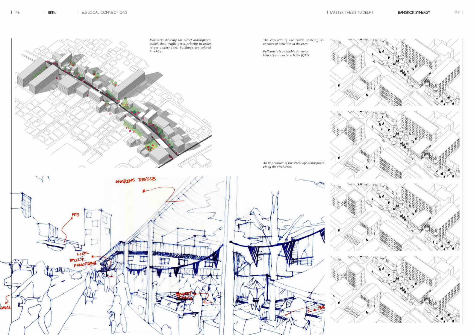
An impression of the street life atmosphere along the vital street
Isometric showing the street atmosphere, which slow traffic get a priority in order to get vitality (new buildings are colored in white)
The captures of the movie showing se-quences of activities in the area.
Full movie is available online at: http://youtu.be/mwJLXmfQTFc
6.5 LOCAL CONNECTIONS MASTER THESIS TU DELFTBKKs BANGKOK SYNERGY146 147
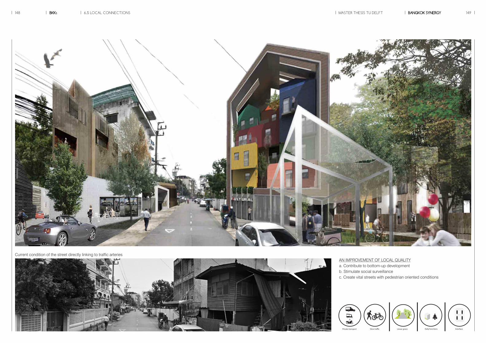
6.5 LOCAL CONNECTIONS MASTER THESIS TU DELFTBKKs BANGKOK SYNERGY148 149
AN IMPROVEMENT OF LOCAL QUALITYa. Contribute to bottom-up developmentb. Stimulate social surveillancec. Create vital streets with pedestrian oriented conditions
Slow tra�c
Station area
Global patch
Local patch
Interface
Urban park
Local business
Daily functionsLinear green
Riverside communityBlue network
TOD
Station square
Mobility Landscape Typology Patch
Private transport
Public transport
Mass transit
to MTS
Slow tra�c
Station area
Global patch
Local patch
Interface
Urban park
Local business
Daily functionsLinear green
Riverside communityBlue network
TOD
Station square
Mobility Landscape Typology Patch
Private transport
Public transport
Mass transit
to MTS
Slow tra�c
Station area
Global patch
Local patch
Interface
Urban park
Local business
Daily functionsLinear green
Riverside communityBlue network
TOD
Station square
Mobility Landscape Typology Patch
Private transport
Public transport
Mass transit
to MTS
Slow tra�c
Station area
Global patch
Local patch
Interface
Urban park
Local business
Daily functionsLinear green
Riverside communityBlue network
TOD
Station square
Mobility Landscape Typology Patch
Private transport
Public transport
Mass transit
to MTS
Slow tra�c
Station area
Global patch
Local patch
Interface
Urban park
Local business
Daily functionsLinear green
Riverside communityBlue network
TOD
Station square
Mobility Landscape Typology Patch
Private transport
Public transport
Mass transit
to MTS
Current condition of the street directly linking to traffic arteries

BKKs150
Source : www.skyscrapercity.com
151BANGKOK SYNERGYMASTER THESIS TU DELFT
Chapter 7MANAGEMENT STRATEGY
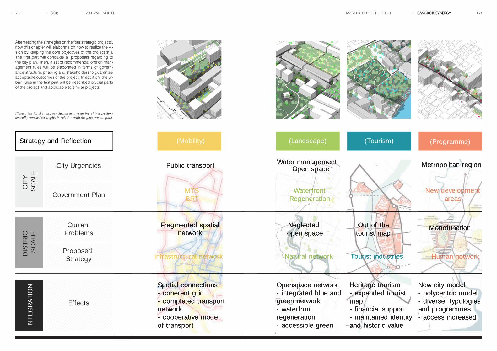
BKKs152 MASTER THESIS TU DELFT BANGKOK SYNERGY 1537.1 EVALUATION
Illustration 7.1 showing conclusion as a meaning of integration: overall proposed strategies in relation with the government plan
After testing the strategies on the four strategic projects, now this chapter will elaborate on how to realize the vi-sion by keeping the core objectives of the project still. The first part will conclude all proposals regarding to the city plan. Then, a set of recommendations on man-agement rules will be elaborated in terms of govern-ance structure, phasing and stakeholders to guarantee acceptable outcomes of the project. In addition, the ur-ban rules in the last part will be described crucial parts of the project and applicable to similar projects.
CIT
YSC
ALE
DIS
TRIC
SCAL
EIN
TEG
RAT
ION
Effects
Public transport
Infrastructural network
Spatial connections- coherent grid- completed transport network- cooperative modeof transport
Fragmented spatialnetwork
MTSBRT
(Mobility)Strategy and Reflection
Water managementOpen space
Openspace network- integrated blue and green network- waterfront regeneration- accessible green
Neglectedopen space
WaterfrontRegeneration
Natural network
(Landscape)
Heritage tourism- expanded tourist map- financial support- maintained identityand historic value
Out of thetourist map
-
-
Tourist industries
(Tourism)
Metropolitan region
New city model- polycentric model- diverse typologiesand programmes - access increased
Monofunction
New developmentareas
Human network
(Programme)
CurrentProblems
ProposedStrategy
Government Plan
City Urgencies
CIT
YSC
ALE
DIS
TRIC
SCAL
EIN
TEG
RAT
ION
Effects
Public transport
Infrastructural network
Spatial connections- coherent grid- completed transport network- cooperative modeof transport
Fragmented spatialnetwork
MTSBRT
(Mobility)Strategy and Reflection
Water managementOpen space
Openspace network- integrated blue and green network- waterfront regeneration- accessible green
Neglectedopen space
WaterfrontRegeneration
Natural network
(Landscape)
Heritage tourism- expanded tourist map- financial support- maintained identityand historic value
Out of thetourist map
-
-
Tourist industries
(Tourism)
Metropolitan region
New city model- polycentric model- diverse typologiesand programmes - access increased
Monofunction
New developmentareas
Human network
(Programme)
CurrentProblems
ProposedStrategy
CurrentCurrentCurrentProblemsCurrent
ProblemsCurrent
ProblemsCurrent
ProblemsCurrent
ProblemsProblemsProblemsProblemsCurrentCurrentCurrentCurrent
ProblemsCurrent
ProblemsProblemsProblemsProblemsProblems
ProposedProposedProposedStrategy
ProposedStrategy
ProposedStrategy
ProposedStrategy
ProposedStrategyStrategyStrategyStrategy
ProposedProposedStrategy
ProposedStrategy
ProposedStrategyStrategyStrategyStrategy
ProposedProposedProposedProposedProposedProposedProposedProposedProposedProposedProposedProposedProposed
Government Plan
City UrgenciesCity UrgenciesCity UrgenciesCity UrgenciesCity UrgenciesCity UrgenciesCity UrgenciesCity UrgenciesCity UrgenciesCity UrgenciesCity UrgenciesCity UrgenciesCity UrgenciesCity UrgenciesCity UrgenciesCity UrgenciesCity UrgenciesCity UrgenciesCity UrgenciesCity Urgencies
Government PlanGovernment PlanGovernment PlanGovernment PlanGovernment PlanGovernment PlanGovernment PlanGovernment PlanGovernment PlanGovernment PlanGovernment PlanGovernment PlanGovernment PlanGovernment PlanGovernment PlanGovernment PlanGovernment PlanGovernment PlanGovernment PlanGovernment PlanGovernment Plan
CIT
YSC
ALE
DIS
TRIC
SCAL
EIN
TEG
RAT
ION
Effects
Public transport
Infrastructural network
Spatial connections- coherent grid- completed transport network- cooperative modeof transport
Fragmented spatialnetwork
MTSBRT
(Mobility)Strategy and Reflection
Water managementOpen space
Openspace network- integrated blue and green network- waterfront regeneration- accessible green
Neglectedopen space
WaterfrontRegeneration
Natural network
(Landscape)
Heritage tourism- expanded tourist map- financial support- maintained identityand historic value
Out of thetourist map
-
-
Tourist industries
(Tourism)
Metropolitan region
New city model- polycentric model- diverse typologiesand programmes - access increased
Monofunction
New developmentareas
Human network
(Programme)
CurrentProblems
ProposedStrategy
Government Plan
City Urgencies
CIT
YSC
ALE
DIS
TRIC
SCAL
EIN
TEG
RAT
ION
Effects
Public transport
Infrastructural network
Spatial connections- coherent grid- completed transport network- cooperative modeof transport
Fragmented spatialnetwork
MTSBRT
(Mobility)Strategy and Reflection
Water managementOpen space
Openspace network- integrated blue and green network- waterfront regeneration- accessible green
Neglectedopen space
WaterfrontRegeneration
Natural network
(Landscape)
Heritage tourism- expanded tourist map- financial support- maintained identityand historic value
Out of thetourist map
-
-
Tourist industries
(Tourism)
Metropolitan region
New city model- polycentric model- diverse typologiesand programmes - access increased
Monofunction
New developmentareas
Human network
(Programme)
CurrentProblems
ProposedStrategy
Government Plan
City Urgencies Metropolitan region
New city model- polycentric model- diverse typologiesand programmes - access increased
Monofunction
New developmentareas
Human network
Heritage tourism- expanded tourist map- financial support- maintained identityand historic value
Out of thetourist map
-
-
Tourist industries
Water managementOpen space
Openspace network- integrated blue and green network- waterfront regeneration- accessible green
Neglectedopen space
WaterfrontRegeneration
Natural network
Public transport
Infrastructural network
Spatial connections- coherent grid- completed transport network- cooperative modeof transport
Fragmented spatialnetwork
MTSBRT

BKKs154 MASTER THESIS TU DELFT BANGKOK SYNERGY 155
Local participationTo deal with potentials of an im-proved spatial quality, which will be done better than the ordinary model, it is very important to reor-ganize the governance structure of the city. The new model welcomes local people to be in the planning process. The reason is that for the historic core, the historical continu-ity is crucial. Localness will be pro-duced by local inhabitants. With this approach, it brings sustainability to the areas. Besides, many conflicts can be solved more easily, when the three parties are put together in a discussion, which leads to common interests and a balance in power re-lation among those groups. These vulnerable groups will be preserved and able to get reasonable benefits from global development. There-fore, as never happened, integra-tion of the MTS and the urban tissue results from cooperation between global and local dimensions.
Inflexibility: Drawbacks of the tradi-tional modelThe current condition of the city management structure is that the municipal parties and other pub-lic sectors regulate city spaces through zoning systems, capital planning and other kind of regula-tory frameworks. The intensity of control makes plans more inflexible and anti organic growth.The thesis focuses on a potential of flexibility in planning, which is able to accumulate and cope with changes and demands of local in-habitants. By enhancing crucial aspects to facilitate local patterns in order to make city life continue and leave other parts still the same, these step-by-step changes can fulfil basic needs of local residents and give a chance for initiatives and individual decision making in reprogramming by civic parties. Therefore, public policies are highly needed, which will provide a regu-latory framework regarding specific context.
Public sectorsThe infrastructure development in Bangkok is usually done by public sectors. Responsible authorities also give a plan to cope with expect-ed consequences, and then private sectors come in and take actions on the investment. Therefore, authori-ties need to be fair democratically in making decision and clear objec-tives. They should provide oppor-tunities to invest for public interest and ensure to be safe that the core objectives will not change. Moreo-ver, they should bring local into the process, because it is important for the area, which has historic value, to have local participation and raise their awareness. This management leads to a consensus and common interests of cooperation between these three sectors, initially done by the government.
Private SectorsPrivate sector is the main investor of the project to keep the project going more dynamically and flexibly. Sev-eral private sectors, who can join the project, are banking companies, transport related organizations, real estate developers and so on. Some private sectors may benefit directly from the project. One example is the MTS station along the main Road, where the adjacent building and real estate are connected directly to the MTS stop or new open spaces. The financial strategy for this condition is to include the adjacent building and real estate as the investor of the adjacent stop. In other word, the ad-jacent building and real estate need to maintain the MTS stop and open space with bonus and subsidy to get acceptable profits by maintain-ing and supporting the strategy.
Citizens The role of citizens is to participate into the project. The main goal of the project is to improve integration be-tween the historic core and the MTS, thus it is important to know the exist-ing quality of life in affected neigh-borhoods. Local residents will get a higher priority to invest in the project and give a decision on the ongo-ing process. This is the reason why a variety of building typologies and scale is very important in mixing bal-ance of functions and the provision ( new housing and affordable hous-ing) . In terms of local businesses, typologies provided are adaptable, which economic activities are possi-ble to take place on the ground floor. Besides, pocket spaces are allowed to use by local temporarily such as open markets. As a result, it will pre-serve local quality of Bangkok
Involving partiesTo realize the goal, the illustration 7.2 and the diagrams below shows involving sectors of the project.
7.2 GOVERNANCE STRUCTURE
Developer’sActions
(private sectors,local initiatives)
PublicSector
ResposibleDivisions
Actions
Strategy
PlanBuild spatialconnections
Support heritageconservation
Environmental controlMonitor Heritage tourism
Facilitate tourism industries
MTS construction
BMAGOVERNMENT ORGANIZATIONS
Maintainance Investment
Department of City Planning
Department of Tra�c and Transport
Natural and Cultural Environmental Conservation Division
Bangkok Tourist Division
Bangkok Mass Transit Authority UNESCO
Infrastructural network(Mobility)
Natural network(Landscape)
Human network(Programme)
Tourist industries( Urban Heritage)
Illustration 7.2 showing responsible par-ties of the project in line with proposed strategies
INTEGRATIONMODEL
Government
BMA
District
Internationalorganization
Non governmetnalorganization
Neighborhoodorganization
Land owners
Real estatedevelopers
Investors
Control
(Legally)Consensus
Evaluation,Direction
Promised bene�ts
Incentive(Bonus,
Subsidy,Tax break,
Gauranteed revenues)
Captial- intensive
(maintain, operate)
Public-Private
Partnership
CITIZ
ENS
PRIVATE
PUBLIC
CITIZ
ENS
PRIVATE
PUBLIC
The diagram shows different involving parties in three working scale.
The diagram shows inputs and outputs from different parties with the idea of public-private partnership.

BKKs156 MASTER THESIS TU DELFT BANGKOK SYNERGY 157
Bus stop
Demolition of buildings
Reorganization of BRT
MTS
New road connections
Slow tra�c network
Upgrade to tram
to the area throughout Bangkok
A�ordable housings
Linear park
Canal regeneration
Public park
Waterfront regeneration
Tourist bus
De�ned tourist areas
Retail in the local areas
Service functions
Development alongtransit corridors
Neighborhood transformation
INFRASTRUCTURE
INFRASTRUCTURE
Government plan
Short term goals Long term goals
Proposed proporsal
OPEN SPACE
TOURIST INDUSTRIES
URBAN DEVELOPMENT
2010 2015 2020 2025 2030
to the area to the area throughout Bangkokthroughout Bangkokthroughout Bangkok
Estimated completion
time of the mts
Civic sectorsPrivate sectorsPublic sectorsStrategy
The illustration 7.3 reveals the rela-tion between project phasing and actors. Public sectors are respon-sible for basic needs of citizens, which in this case, are infrastruc-ture , public spaces and other lo-cal related facilities, considered as short term objectives. For long term goals, after the MTS completes in the area , interventions by the state encourage urban development mostly done by local initiatives and private parties. These actions aim to add value in sustainable ways by making use of potentials of integra-tion of two dynamics.
It starts with an introduction of the integrated and connected network on potential areas to create a flow for the increasing people and trans-formed urban quality. The second phase is a refurbishment of the existing building into a compact mixed-use residential-retail devel-opment and the enhancing urban quality by transforming open space to create a more efficient land use of the area. In terms of quantity, after the completed MTS, the third strat-egy is the establishment of mixed-use functions and housings to cre-ate more space in order to increase value of the area and attract users to stimulate economic activities. Therefore, after the MTS completion in the area, the evaluation is need-ed in order to develop the flexible framework (see illustration 7.4).
The flexibility of planningIn relation with the phasing strategy, this project is based around a set of guidelines to protect threats by the MTS towards local inhabitants. The expansion of MTS brings more people to a place that is once un-connected because of the increas-ing traffic and low mobility as well as the fragmented network will be reor-ganized and connected. Therefore, as mentioned before, the phasing strategy is divided into two parts, before and after the implementation of the MTS.
7.3 PHASING
Illustration 7.3 showing the phasing strategy of the project classified into short term and long term objectives
Illustration 7.4 showing the roles of differ-ent stakeholders in accordance to the four proposed strategies
INFRASTRUCTURE OPEN SPACE TOURIST INDUSTRIES URBAN DEVELOPMENT
+ + +
- Cooperate with private developers- Control by policies and bonus systems
- Has an initial role of the process of tranformation in both green and blue networks as same as main-tainance them
- Cooperate with civic sectors in terms of partici-pation and rising aware-ness.- Promote heritage tourism- Subsidize nearby areas
- Cooperate with private sectors to develop areas along transit corridors- Invest in basic needs; a�ordable housing to bring social mix to the area
- bene�t from a chance to invest in service functions which help maintain openspaces
- Bene�t from accessibility to tourist destinations- Channel bene�t back to lacal as �nancial supportand tax to be used as subsidy
- Cooperate with public sectors- Develop towards diversity and density- Provide work and live environment to local
- Cooperate with public sectors- Invest in the infrastructure development and its proximity (transit corridor)
- Bene�t from the improv-ment of mobility and multi modal transport
- Bene�t from accessible openspaces and functions which reduce travel distance- Maintain the cultural landscale
- Work with the state- Strengthen historic values and cultural identity- Bene�t from tourist industries
- Bene�t from diverse typologies and functions- Get a chance to refurbish existing quality- Enhance local economy and social cohesion
Civic sectorsPrivate sectorsPublic sectorsStrategy
7.4 STAKEHOLDERS
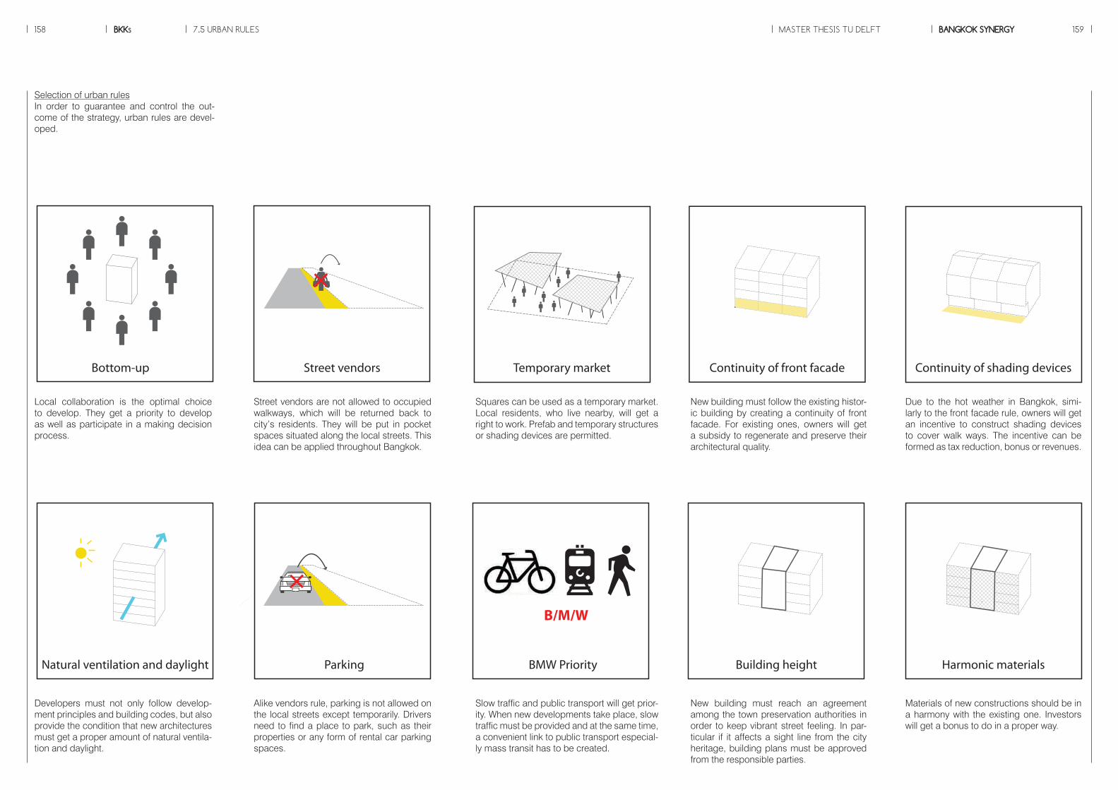
Selection of urban rulesIn order to guarantee and control the out-come of the strategy, urban rules are devel-oped.
Developers must not only follow develop-ment principles and building codes, but alsoprovide the condition that new architectures must get a proper amount of natural ventila-tion and daylight.
Alike vendors rule, parking is not allowed on the local streets except temporarily. Drivers need to find a place to park, such as their properties or any form of rental car parking spaces.
Slow traffic and public transport will get prior-ity. When new developments take place, slow traffic must be provided and at the same time, a convenient link to public transport especial-ly mass transit has to be created.
New building must reach an agreement among the town preservation authorities in order to keep vibrant street feeling. In par-ticular if it affects a sight line from the city heritage, building plans must be approved from the responsible parties.
Materials of new constructions should be in a harmony with the existing one. Investors will get a bonus to do in a proper way.
7.5 URBAN RULES MASTER THESIS TU DELFTBKKs BANGKOK SYNERGY158 159
Local collaboration is the optimal choice to develop. They get a priority to develop as well as participate in a making decision process.
Street vendors are not allowed to occupied walkways, which will be returned back to city’s residents. They will be put in pocket spaces situated along the local streets. This idea can be applied throughout Bangkok.
Squares can be used as a temporary market. Local residents, who live nearby, will get a right to work. Prefab and temporary structures or shading devices are permitted.
New building must follow the existing histor-ic building by creating a continuity of front facade. For existing ones, owners will get a subsidy to regenerate and preserve their architectural quality.
Due to the hot weather in Bangkok, simi-larly to the front facade rule, owners will get an incentive to construct shading devices to cover walk ways. The incentive can be formed as tax reduction, bonus or revenues.
Bottom-up Temporary market
+
Street vendors Continuity of front facade Continuity of shading devices
Natural ventilation and daylight Parking
+
BMW Priority
B/M/W
Building height Harmonic materials
Bottom-up Temporary market
+
Street vendors Continuity of front facade Continuity of shading devices
Natural ventilation and daylight Parking
+
BMW Priority
B/M/W
Building height Harmonic materials

BKKs160
Source : www.skyscrapercity.com
MASTER THESIS TU DELFT BANGKOK SYNERGY 161
Chapter 8REFLECTION

8.1 EVALUATION MASTER THESIS TU DELFTBKKs BANGKOK SYNERGY162 163
built environments (to use organ-ized network connections as cata-lysts for urban development).
The design part is a concrete prod-uct of the strategy of the project. It illustrates spatial impacts of the strategy with optimal solutions. The main components and projects will not define all elements, but identify and visualize the main ideas to re-spond to the objective of the thesis.
The strategy management part is evaluated the outcomes in relation to the top-down plan by the govern-ment. Additionally, the management strategy is defined in a way of both short-term and long-term goals to coordinate with different stakehold-ers, which define a success of an implementation of strategy.
The forth chapter analyzes on the rapid process of city development. The effect of the process unfolds several spatial problems of the stra-tegic location that needs to be in-tervened, classified in three issues (spatial fragmentation, environmen-tal degradation and social segrega-tion respectively).
The strategy part is the most ex-plorative as the exercise of visioning concepts on different layers in order to create the desirable future. The four strategies tackle with different issues; mobility (to reorganize spa-tial network hierarchy and propose multi modal mobility), public space (to transform urban fragmentation into coherent urban spaces), tour-ism (to promote cultural and herit-age tourism with local benefits) and
ity, integration definition becomes concrete and also spatial indicators to be used in the design process. The theoretical framework gives the author opportunities not only to construct concrete evidences and knowledge, but also to identify weaknesses and threats provided by academic research.
The part context research and analy-sis explains the main elements in or-der to have a better understanding of the context from the past shaping the existing urban form. It provides a comprehension of city dynamics showing opportunities and poten-tialities. The applied methodology allows the author to explore each layer that structures the society on the following section from the em-pirical research.
the city of Bangkok and strategies through the exploration of probable future in 2030. Secondly, to develop design instruments for planners, decision makers and related disci-plines enables to translate scientific knowledge into an approach, which planners can cope with developing strategies for a sustainable future. The assessment will reflect the an-swers of the proposed questions on how the thesis responds to the aims. How the thesis relates to the research questions stated at the beginning of the process? What are the recommendations that the con-clusion suggests?
ReflectionsA significant part of the process is the definition of the thesis plan, as described in the thesis, Bangkok is
challenged by the new infrastructure development, which passes the his-toric core, but unfortunately without coordinating with any preservation plan. Therefore, the definition of the approach and the methodology was decisive to formulate the the-sis project to fill this gap by sharing the goal to make use of potentials by this top-down intervention and at the same time protect the city’s heart.
The second part lies on a project framework by starting from theo-ries. It provides a clear concept of both two dynamics (the MTS and heritage), such as spatial network, TOD and mobility for the MTS. Liv-ing heritage and heritage tourism are in line with the heritage related aspects. With a goal as urban vital-
IntroductionIn the evaluation part, the thesis will be summarized with the reflec-tions and recommendations. The assessments have been developed in two levels: first, the reflection of the process of the thesis (research), and second, the assessment of the result of strategy.As mentioned before, the main aim of the thesis is to provide a syner-getic spatial vision for the MTS to integrate with the historic core of
Illustration 8.1 showing the conclusion of the study of Bangkok Synergy; a synergetic spatial vision to preserve the historic core of Bangkok, integrated with the expansion of the rapid mass transit system network, including both research and design process
Framework
Vision
Approach
Site selection
04EMPIRICAL RESEARCH
05STRATEGY
Infrastructure
Landscape
Tourism
Built environment
06STRATEGIC PROJECTS
MTS stations
Spatial barriers
Riverside areas
Local connections
07MANAGEMENT
STRATEGY
Evaluation
Stakeholders
Phasing
08REFLECTION
Recommendations
Planning tools
Design guidelines
The MTS
Heritage
Spatial indicatorsof urban vitality
02THEORETICALRESEARCH
Problem definition
Project aim
Methodology
01INTRODUCTION
Historical research
City urgencies
Top-down plan review
03CONTEXT RESEARCH
AND ANALYSIS
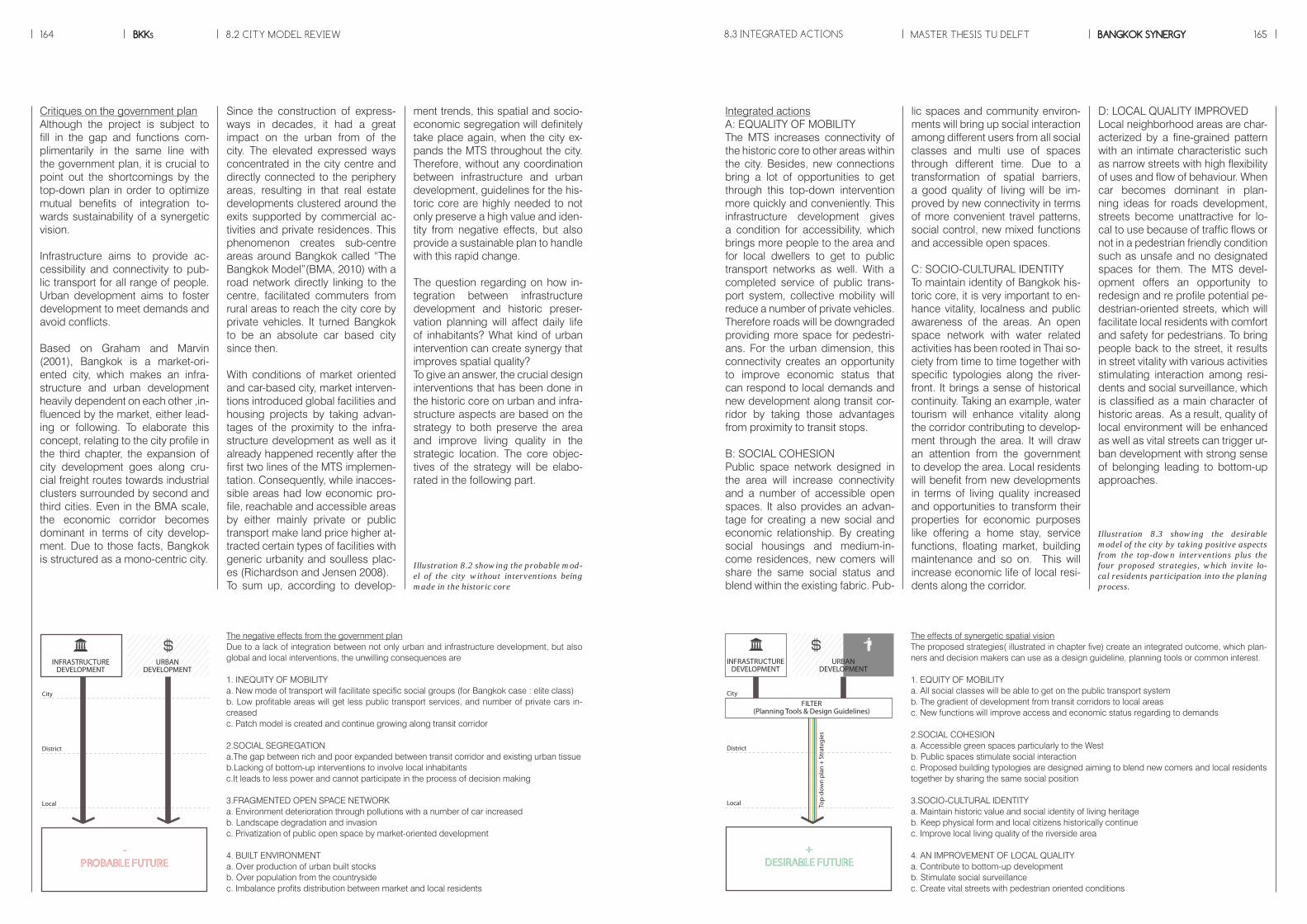
8.2 CITY MODEL REVIEW MASTER THESIS TU DELFTBKKs BANGKOK SYNERGY164 165
lic spaces and community environ-ments will bring up social interaction among different users from all social classes and multi use of spaces through different time. Due to a transformation of spatial barriers, a good quality of living will be im-proved by new connectivity in terms of more convenient travel patterns, social control, new mixed functions and accessible open spaces.
C: SOCIO-CULTURAL IDENTITYTo maintain identity of Bangkok his-toric core, it is very important to en-hance vitality, localness and public awareness of the areas. An open space network with water related activities has been rooted in Thai so-ciety from time to time together with specific typologies along the river-front. It brings a sense of historical continuity. Taking an example, water tourism will enhance vitality along the corridor contributing to develop-ment through the area. It will draw an attention from the government to develop the area. Local residents will benefit from new developments in terms of living quality increased and opportunities to transform their properties for economic purposes like offering a home stay, service functions, floating market, building maintenance and so on. This will increase economic life of local resi-dents along the corridor.
D: LOCAL QUALITY IMPROVEDLocal neighborhood areas are char-acterized by a fine-grained pattern with an intimate characteristic such as narrow streets with high flexibility of uses and flow of behaviour. When car becomes dominant in plan-ning ideas for roads development, streets become unattractive for lo-cal to use because of traffic flows or not in a pedestrian friendly condition such as unsafe and no designated spaces for them. The MTS devel-opment offers an opportunity to redesign and re profile potential pe-destrian-oriented streets, which will facilitate local residents with comfort and safety for pedestrians. To bring people back to the street, it results in street vitality with various activities stimulating interaction among resi-dents and social surveillance, which is classified as a main character of historic areas. As a result, quality of local environment will be enhanced as well as vital streets can trigger ur-ban development with strong sense of belonging leading to bottom-up approaches.
Integrated actionsA: EQUALITY OF MOBILITYThe MTS increases connectivity of the historic core to other areas within the city. Besides, new connections bring a lot of opportunities to get through this top-down intervention more quickly and conveniently. This infrastructure development gives a condition for accessibility, which brings more people to the area and for local dwellers to get to public transport networks as well. With a completed service of public trans-port system, collective mobility will reduce a number of private vehicles. Therefore roads will be downgraded providing more space for pedestri-ans. For the urban dimension, this connectivity creates an opportunity to improve economic status that can respond to local demands and new development along transit cor-ridor by taking those advantages from proximity to transit stops.
B: SOCIAL COHESIONPublic space network designed in the area will increase connectivity and a number of accessible open spaces. It also provides an advan-tage for creating a new social and economic relationship. By creating social housings and medium-in-come residences, new comers will share the same social status and blend within the existing fabric. Pub-
Since the construction of express-ways in decades, it had a great impact on the urban from of the city. The elevated expressed ways concentrated in the city centre and directly connected to the periphery areas, resulting in that real estate developments clustered around the exits supported by commercial ac-tivities and private residences. This phenomenon creates sub-centre areas around Bangkok called “The Bangkok Model”(BMA, 2010) with a road network directly linking to the centre, facilitated commuters from rural areas to reach the city core by private vehicles. It turned Bangkok to be an absolute car based city since then.
With conditions of market oriented and car-based city, market interven-tions introduced global facilities and housing projects by taking advan-tages of the proximity to the infra-structure development as well as it already happened recently after the first two lines of the MTS implemen-tation. Consequently, while inacces-sible areas had low economic pro-file, reachable and accessible areas by either mainly private or public transport make land price higher at-tracted certain types of facilities with generic urbanity and soulless plac-es (Richardson and Jensen 2008). To sum up, according to develop-
ment trends, this spatial and socio-economic segregation will definitely take place again, when the city ex-pands the MTS throughout the city. Therefore, without any coordination between infrastructure and urban development, guidelines for the his-toric core are highly needed to not only preserve a high value and iden-tity from negative effects, but also provide a sustainable plan to handle with this rapid change.
The question regarding on how in-tegration between infrastructure development and historic preser-vation planning will affect daily life of inhabitants? What kind of urban intervention can create synergy that improves spatial quality?To give an answer, the crucial design interventions that has been done in the historic core on urban and infra-structure aspects are based on the strategy to both preserve the area and improve living quality in the strategic location. The core objec-tives of the strategy will be elabo-rated in the following part.
The negative effects from the government planDue to a lack of integration between not only urban and infrastructure development, but also global and local interventions, the unwilling consequences are
1. INEQUITY OF MOBILITY a. New mode of transport will facilitate specific social groups (for Bangkok case : elite class)b. Low profitable areas will get less public transport services, and number of private cars in-creasedc. Patch model is created and continue growing along transit corridor
2.SOCIAL SEGREGATIONa.The gap between rich and poor expanded between transit corridor and existing urban tissueb.Lacking of bottom-up interventions to involve local inhabitantsc.It leads to less power and cannot participate in the process of decision making
3.FRAGMENTED OPEN SPACE NETWORKa. Environment deterioration through pollutions with a number of car increasedb. Landscape degradation and invasionc. Privatization of public open space by market-oriented development
4. BUILT ENVIRONMENTa. Over production of urban built stocksb. Over population from the countrysidec. Imbalance profits distribution between market and local residents
The effects of synergetic spatial visionThe proposed strategies( illustrated in chapter five) create an integrated outcome, which plan-ners and decision makers can use as a design guideline, planning tools or common interest.
1. EQUITY OF MOBILITY a. All social classes will be able to get on the public transport systemb. The gradient of development from transit corridors to local areasc. New functions will improve access and economic status regarding to demands
2.SOCIAL COHESIONa. Accessible green spaces particularly to the Westb. Public spaces stimulate social interactionc. Proposed building typologies are designed aiming to blend new comers and local residents together by sharing the same social position
3.SOCIO-CULTURAL IDENTITYa. Maintain historic value and social identity of living heritage b. Keep physical form and local citizens historically continuec. Improve local living quality of the riverside area 4. AN IMPROVEMENT OF LOCAL QUALITYa. Contribute to bottom-up developmentb. Stimulate social surveillancec. Create vital streets with pedestrian oriented conditions
Critiques on the government planAlthough the project is subject to fill in the gap and functions com-plimentarily in the same line with the government plan, it is crucial to point out the shortcomings by the top-down plan in order to optimize mutual benefits of integration to-wards sustainability of a synergetic vision.
Infrastructure aims to provide ac-cessibility and connectivity to pub-lic transport for all range of people. Urban development aims to foster development to meet demands and avoid conflicts.
Based on Graham and Marvin (2001), Bangkok is a market-ori-ented city, which makes an infra-structure and urban development heavily dependent on each other ,in-fluenced by the market, either lead-ing or following. To elaborate this concept, relating to the city profile in the third chapter, the expansion of city development goes along cru-cial freight routes towards industrial clusters surrounded by second and third cities. Even in the BMA scale, the economic corridor becomes dominant in terms of city develop-ment. Due to those facts, Bangkok is structured as a mono-centric city.
8.3 INTEGRATED ACTIONS
INFRASTRUCTUREDEVELOPMENT
URBANDEVELOPMENT
City
District
Local
INFRASTRUCTUREDEVELOPMENT
FILTER(Planning Tools & Design Guidelines)
URBANDEVELOPMENT
City
District
Top-
dow
n pl
an +
Str
ateg
ies
Local
Illustration 8.2 showing the probable mod-el of the city without interventions being made in the historic core
Illustration 8.3 showing the desirable model of the city by taking positive aspects from the top-down interventions plus the four proposed strategies, which invite lo-cal residents participation into the planing process.

SUSTAINABLE MOBILITY: to provide a large choices of transport modes, affordable and convenient transit: to increase accessibility by new connections and public transport: to reduce car dependency and traffic congestion as consequential outcomes: to reduce environmental impact: to redefine social and spatial fragmentation OPEN SPACE NETWORK: to create accessible greens to increase a quantity of green per person: to improve living quality of local residents: to integrate open space into a network
SUSTAINABLE TOURISM: to provide cultural and heritage tourism with local benefits
URBAN INTEGRATION: to strengthen an economic growth through the integration of urban areas: to shorten commuting pattern and travelling time through land use planning and zoning regulation
EFFICIENT LAND MANAGEMENT: to allocate land stocks reserved and the land value for the future based on the objectives
GOOD GOVERNANCE : to rebalance structure of governance in order to facilitate and support the process of spatial planning : to manage and distribute resources efficiently and allow all stakeholders to get reasonable benefits
POLYCENTRIC CITY : to transform dependent and independent areas into a complementary relation between the core and sub centres with an improvement of infrastructure and urban development: to reinforce sub centres to promote identity and integration of urban areas
8.4 POSSIBLE SIDE EFFECTS MASTER THESIS TU DELFTBKKs BANGKOK SYNERGY166 167
ConclusionsThe urban fabric of the city has a disorganized street network. Differ-ent strategies have to be developed in order to implement large –scale infrastructure projects (MTS). The main problem of Bangkok’s transit and the city has a low integration on the micro scale between the two dy-namics. To realize this, the strategy should provide a balanced strategic framework on both urban and infra-structure aspects together with an in-depth research before interven-ing. On the infrastructure aspect, the opportunity of equity of mobility must be created. On the urban as-pect, spatial organizations need to be reorganized to meet demands for development and avoid conflicts
RecommendationsThe MTS network of Bangkok needs to be observed not only a solution to overcome automobile depend-ency, but also to integrate to spatial configurations of the city. The poten-tial of integration will create a more compact city, which will transform fragmentations and at the same time revitalize existing neighbor-hoods. Due to an uncertain future, the project has been made flexibly in terms of implementation. Be-sides, it is important that all kinds of people can benefit from the project. Collaboration between designers, planner, market and politicians are crucial as well as local participation.The evaluation of the results allows observing a package of recommen-dations that have been considered as being essential to the strategy. All of them lead to a construction of the desirable future for Bangkok, which allows vulnerable groups to benefit from it.
As aforementioned, Bangkok is classified market oriented. In the historic core, cultural value and identity have been maintained by local people from time to time. How-ever, when the market becomes more dominant, the areas may start to be gentrified, which develops to-wards economic issues rather than try to preserve them. Consequently, bottom up process with local par-ticipation is hard to achieve, if the social structure has not been main-tained. In other words, local citizens might not be able or interested to proactively engage in the creation of their cities. The other external factor is negative influences from tourism. These widely threats can be seen via an enclave tourism area and an increase of land price leading to an unaffordable condition for local resi-dents. Finally, it becomes artificial, which results from no longer local dwellers living in the areas.
Possible side effects of the projectThis part aims to describe an uncer-tainty, affected the project. These uncontrollable factors might rise during the process of development. Possible side effects will trigger a discussion or a debate among re-sponsible parties in order to accom-plish the objectives successfully. It can be done by a set of solutions based on a common interest, regu-lation or other forms of control sys-tems. In the project, they are three relevant issues regarding former problems happened to Bangkok.
1. A strong influence by the market leading to gentrification (see illustra-tion 8.4)
2. Without cooperating, bottom up interventions might not succeed as expected (see illustration 8.5)
3. Effects by a boost of tourism(see illustration 8.6)
8.5 RECOMMENDATIONS
Illustration 8.7 showing the transferable disciplines to similar projects dealing with a crash in exploded scale of spatial devel-opment and a conflict between global and local level
TRANSFERABLE DISCIPLINES
Illustration 8.4 showing the Suan-Lum night bazaar, which was replaced by a huge de-partment store and high class condominiums, Source : http://www.chiangmainews.co.th
Illustration 8.5 showing a traditional commercial district (hundreds year old);Nakorn Kasem. It narrates a failure of bottom-up intervention when the state is not willing to preserve. Without a cooperation among stakeholers, the market intervened in this dis-trict leading to a lost of living heritage, Source : http://www.prachachat.net
Illustration 8.5 showing the atmosphere of Khaosan Road, which has turned to be tourist oriented development for decades resulting in an increase in land price and no longer lo-cal residents living in this historic district, Source : http://www.siamvision.com
Spit, L. & Bertolini T. (1998), Cities on rails: the redevelopment of rail-way station areas, London, E & FN Spon
Steinberg, F. (1996), Conservation and Rehabilitation of Urban Herit-age in Developing Countries, Habi-tat INTL, vol. 20, no. 3, pp. 463-475.
Tasaka, T. (1998), Asia no Daitoshi 1, Nihon Hyouronsya, Tokyo.The In-stitute for Economic Research (IER) 1989, Sekai no Daitoshi, University of Tokyo Press, Tokyo.
Urry, J. (2004) Social engineering: responding to Ken Livingstone. Planning Theory and Practice, vol. 5, no. 4, pp. 506–509.
Urry, J. (2007) Mobilities. Cam-bridge: Polity Press.
Warren, W. (2002), Bangkok, Reak-tion Books
Webster, D. (2000), Financing City- Building: The Bangkok Case, Stan-ford, CA: Walter H. Shorenstein Asia-Pacific Research Center, Stan-ford University.
Whyte, W.H. (1980), The Social Life of Small Urban Space, Washington D.C.: Conservation Foundation.
Williams, A, Robles, E & Dourish, P. (2009), Urbane-ing the City: Exam-ing and Refining the Assumptions behind Urban Informatics, New York, Information Science Refer-ence, IGI Global.
Yantrasast, K 1995, Bangkok’s Wa-ter Logic: A study on the phenome-non of water and urban transforma-tion, The university of Tokyo.
WEBSITESBangkok Expressway Co. Ltd.: www.becl.co.thBangkok Mass Transit System Co. Ltd.: www.bts.co.thBangkok Metropolitan Administra-tion: www.bangkok.go.thBangkok Tourism division. :www.bangkoktourist.comDepartment of City Planning, BMA: www.bma-cpd.go.thDepartment of Traffic and Transpor-tation, BMA: www.otp.go.thMass Rapid Transit Authority of Thailand: www.mrta.co.thNatural and Cultural Environmental Conservation: www2.onep.go.thOffice of the National Economic and Social Development Board: www.nesdb.go.th
Department of City Planning Bang-kok Metropolitan Administrator, Bangkok Comprehensive Plan. Available from: <http://cpd.bang-kok.go.th/default.asp>. [10 Octo-ber].
Graham, S & Marvin, S. (2001), Splinter Urbanism, London and New York, Routledge.
Graham, S & Marvin, S. (2008), Splintering Urbanism: Networked Infrastructures, Technological Mo-bilities, and the Urban Condition, Annals of the Association of Ameri-can Geographers, vol. 93, no. 1, pp. 246-247.
Hara, Y, Thaitakoo, D & Takeuchi, K. (2008), Landform Transformation on the Urban Fringe of Bangkok: The need to review land-use planning processes with consideration of the flow of fill materials to developing areas, Journal of Landscape and Urban Planning, vol. 84, pp. 74-91.
Jacobs, M. (2000), Multinodal Ur-ban Structure: A comparative analy-sis and strategies for design, Delft, Delft University Press.
Jenks, M. (2003), Above and below the line: Globalization and urban form in Bangkok, The Annals of Re-gional Science, no. 37, pp. 547-557.
Kanjanapanyakom, R. (2010), MIM: Micro Informal Mobility, Master the-sis, Delft University of Technology.
Karpati, TH. (2008), Management of World Heritage Sites, VDM Verlag.
Kempen, ETv. (1993), The Dual City and the Poor: Social Polarisation, Social Segregation and Life Chanc-es, Journal of Urban Studies, vol. 31, no. 7, pp. 995-1015.
Kishiue, A, Cal, PC, Amano, K & Lidasan, HS. (2005), The Leading Factors for the Urban Development in Asian Context: Case Studies of Makati, Cebu, Taipei and Bangkok, Journal of the Eastern Asia Society for Transportation Studies, vol. 6, pp. 4300-4316.
Marcuse, P. ‘Dual City’: a muddy metaphor for a quartered city, In-ternational Journal of Urban and Regional Research, vol. 13, pp. 697–708.
Mcgrath, B. (2005), Bangkok’s CSD, 306090 Regarding Public Space, vol. 9, pp. 46-53.
Montgomery, J. (1998), Making a city: Urbanity, vitality and urban de-sign, Journal of Urban Design, vol. 3, no. 1, pp. 93-116.
Poboon, C. (1997), Anatomy of a Traffic Disaster: Towards a Sustaina-ble Solution to Bangkok’s Transport Problems, Murdoch.
Pont, M. B. & Haupt, P. (2010), Spacematrix: Space, Density and Urban Form, Rotterdam, Nai Pub-lishers.
Read, S. (2001), Neighbourhood Spatial Processes: Notes on Pub-lic Space, ‘Thick’ Space, Scale and Centrality, Faculty of Architecture, Delft University of Technology.
Richardson, T. & Jensen O. B. (2008), How Mobility Systems Pro-duce Inequality: Making Mobile Subject Types on the Bangkok Sky Train, Built Environment, vol. 34, no.2, pp. 218-231.
Rodwell, D (2008), Conservation and Sustainability in Historic Cities, Wiley-Blackwell.
Rongwiriyaphanich, S. (2011), Shift-ing Paradigms of the Territorial Or-ganization in the Bangkok Metropol-itan Region: Impacts on form and speed of change in land utilization, Urbanism PHD research 2009-2013.
Sintusingha, S. (2006), Sustain-ability and Urban Sprawl: Alternative screnarios for a Bangkok super-block, Urban Design International, vol. 11, pp. 151-172.
Smith, N. (1996), The new urban frontier: Gentrification and revan-chist city, New York, Routledge.
LITERATUREAppleyard, D. (1979), The conserva-tion of European cities, Massachu-sets, The MIT Press.
Askew, M. (1994), Interpreting Bangkok, Bangkok, Chulalongkorn University Press.
Askew, M. (2002), Bangkok Place, Practice and Representation, Lon-don and Newyork. Routledge.
Atipothi, K. (2010), Bangkok China-town World Heritage. Available from: <http://www.arsomsilp.ac.th/>.
Balbo, M. (1993), Urban Planning and the Fragmented City of Devel-oping Countries, Third World Plan-ning Review, vol. 15, no. 1, pp. 23–35.
Browder, JO, Bohland, JR & Scar-paci, JL. (1995), Patterns of Devel-opment on Metropolitan Fringe: Ur-ban Fringe Expansion in Bangkok, Jakarta and Santiago, Journal of the American Planning Association, vol. 61:3, pp. 310-327.
Campbell, S. (1996), Green Cities, Growing Cities, Just Cities? Urban planning and the contradictions of sustainable development, Journal of the American Planning Associa-tion, vol. 62, no. 3, pp. 296-312.
Central Intelligence Agency(CIA), The World Factbook, 2011. Available from: <https://www.cia.gov/library/publications/the-world-factbook/>.
Choiejit, R & Teungfung, R. (2005), Urban Growth and Commuting Pat-terns of the Poor in Bangkok, Srina-kharinwirot University, SWU. Raja-mangala Institute of Techonology, RIT.
Clark, T.N. (2003), The City as an Entertainment Machine, Oxford, El-sevier.
Davies, W.K.D. & Herbert, D. T. (1993), Communities with cities, An urban social geography, London, Belhaven Press.
8.2 BIBLIOGRAPHY MASTER THESIS TU DELFTBKKs BANGKOK SYNERGY168 169

SpatialPlanning&Strategy