thekingsschoolgeography.files.wordpress.com€¦ · web viewname:_____ teacher:_____ physical...
TRANSCRIPT

Name:_____________________________________________
Teacher:___________________________________________
Physical Landscapes in the UKRevision Booklet
Paper 1Question 3 & 5
Tuesday 21st May 2019
Use the revision guide to help you complete the booklet and revise.
Not all the answers will be in the guide. You will have to use your class notes to help you.
Useful Websites
https://www.bbc.com/bitesize/examspecs/zy3ptyc
http://www.coolgeography.co.uk/
https://geographycat.co.uk/revision-section
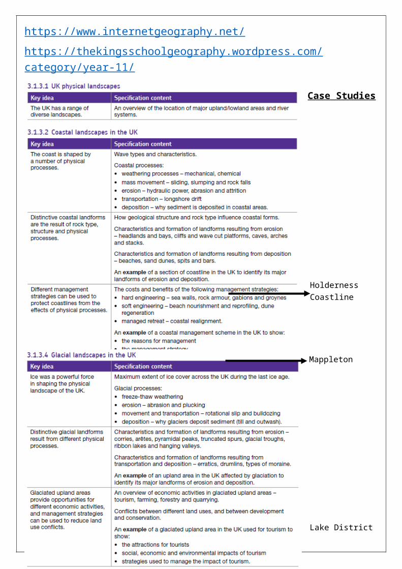
https://www.internetgeography.net/
https://thekingsschoolgeography.wordpress.com/category/year-11/
1
2
Holderness Coastline
Mappleton
Case Studies
Lake District
Lake District
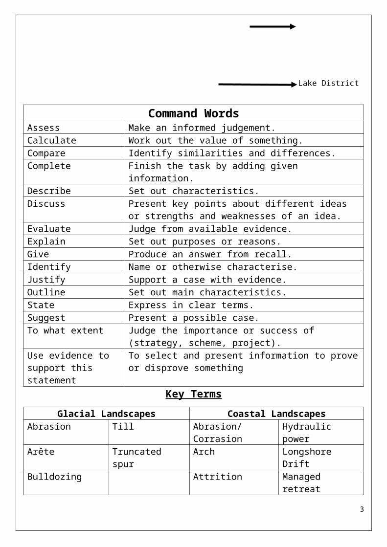
Command WordsAssess Make an informed judgement.Calculate Work out the value of something.Compare Identify similarities and differences.Complete Finish the task by adding given information.Describe Set out characteristics.Discuss Present key points about different ideas or strengths and
weaknesses of an idea.Evaluate Judge from available evidence.Explain Set out purposes or reasons.Give Produce an answer from recall.Identify Name or otherwise characterise.Justify Support a case with evidence.Outline Set out main characteristics.State Express in clear terms.Suggest Present a possible case.To what extent Judge the importance or success of (strategy, scheme,
project).Use evidence to support this statement
To select and present information to prove or disprove something
Key Terms
Glacial Landscapes Coastal LandscapesAbrasion Till Abrasion/Corrasion Hydraulic powerArête Truncated spur Arch Longshore DriftBulldozing Attrition Managed retreatConservation Bar Mass movementCorrie Beach Mechanical
weatheringDrumlin Beach nourishment Rock armourErratics Beach reprofiling Sand duneFreeze thaw weathering
Cave Sea wall
Glacial trough Chemical Weathering SlidingHanging valley Cliff SlumpingLand use conflicts Deposition Soft engineeringMoraine Dune regeneration SpitOutwash Erosion StackPlucking Gabion TransportationPyramidal peak Groyne Wave cut platformRibbon lake Hard engineering WavesRotational slip Headlands and bays
3

Types of waveWave characteristic Constructive wave
Wave heightWave length
Type of wave (plunging or spilling)
Strength of swashStrength of backwash
Beach sediment – gain or loss
Annotate the different features of a wave: height, length, crest, and trough.Draw an annotated diagram to show the 3 types of weatheringMechanical Chemical Biological
Draw annotated diagrams to show the 4 types of wave erosion
Exam Practice1. The following paragraph describes how coastal processes are linked. Complete
the paragraph. Choose the correct words from the list below.
4

deposition transported weathering [2 marks]
Erosion and ……………………………………. break down rocks in coastal areas. Sediment is ……………………………………. by the action of waves and tides. Once the waves and tides have lost energy……………………………………. takes place.
2. The sea erodes the coast in a variety of ways.Draw a line to link each process to the correct definition. (4 marks)
Process Definition
Erosion is sand and pebbles being thrown against the coast.
Hydraulic power is the dissolving of some rocks by sea water.
Abrasion is the wearing away of the land.
Attrition is the force of the water against the coast.
Solution is the colliding of rock fragments into each other.
3. The following statements are about the different types of weathering.
Write the correct type of weathering (mechanical, chemical or biological) in the box next to each statement. Each answer may be used once, more than once or not at all.
(3 marks)
A change in both the appearance and the mineral composition of rock.
The effects of plant roots or burrowing animals on rock.
The breaking of rock into smaller pieces without changing its composition.
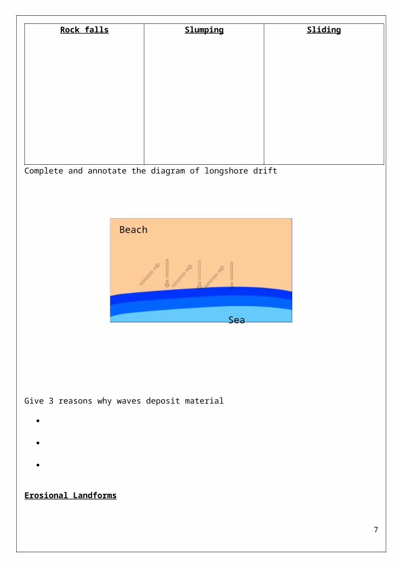
What is mass movement?_______________________________________________________________________________________________________________________
5

Complete 3 simple diagrams and definitions to show the different types of mass movement:
Rock falls Slumping Sliding
Complete and annotate the diagram of longshore drift
Give 3 reasons why waves deposit material
Erosional Landforms
6
Beach
Sea
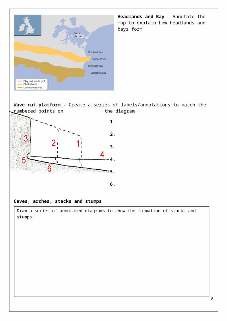
Headlands and Bay – Annotate the map to explain how headlands and bays form
Wave cut platform – Create a series of labels/annotations to match the numbered points on the diagram
1.
2.
3.
4.
5.
6.
Caves, arches, stacks and stumps
Exam Practice
1. Explain how erosional landforms are created during the process of headland retreat. (6 marks)
_________________________________________________________________7
Draw a series of annotated diagrams to show the formation of stacks and stumps.
__________________________________________________________________________________________
__________________________________________________________________________________________
__________________________________________________________________________________________
__________________________________________________________________________________________
__________________________________________________________________________________________
__________________________________________________________________________________________
__________________________________________________________________________________________
__________________________________________________________________________________________
__________________________________________________________________________________________
__________________________________________________________________________________________
__________________________________________________________________________________________
__________________________________________________________________________________________
__________________________________________________________________________________________
__________________________________________________________________________________________
__________________________________________________________________________________________
__________________________________________________________________________________________
__________________________________________________________________________________________
__________________________________________________________________________________________
__________________________________________________________________________________________
__________________________________________________________________________________________
__________________________________________________________________________________________
Depositional landforms
8

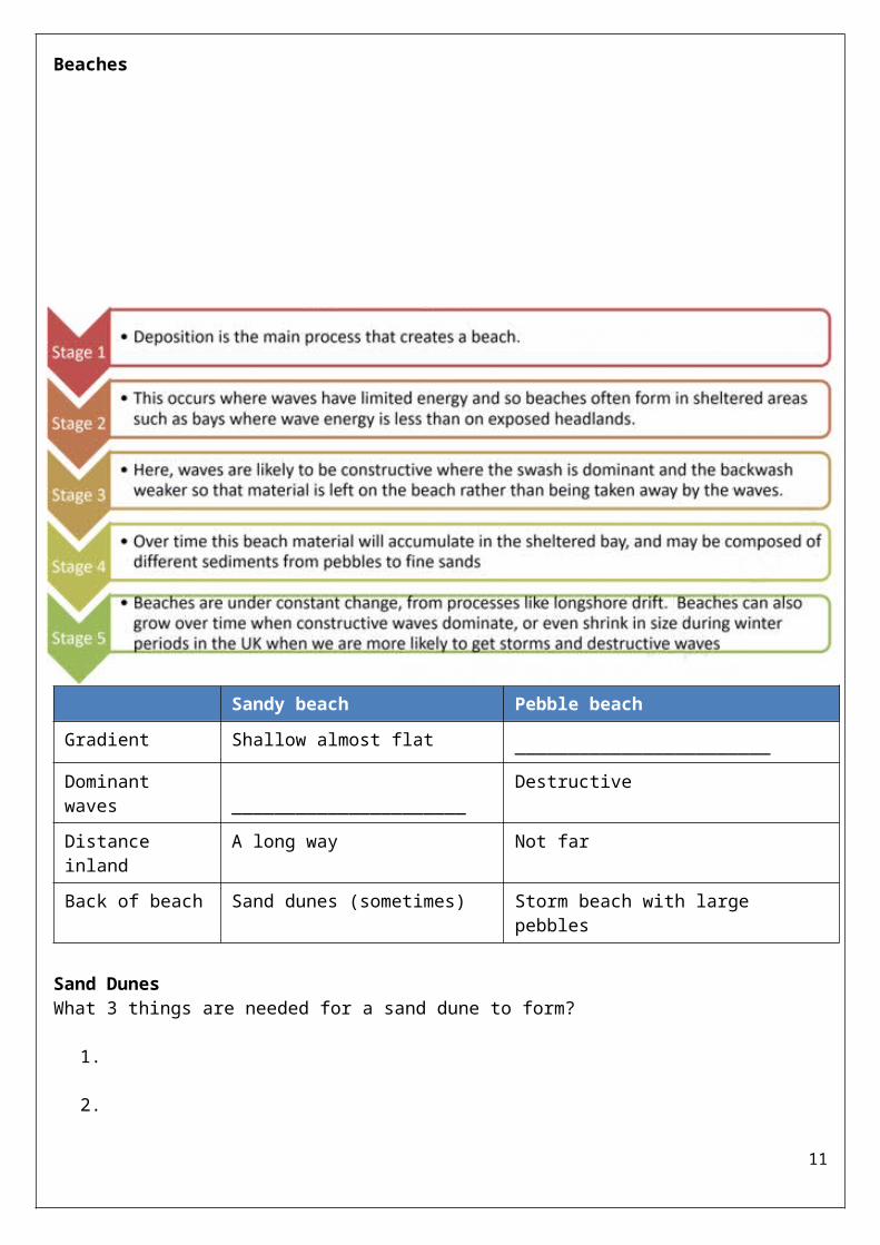
BeachesSandy beach Pebble beach
Gradient Shallow almost flat ________________________Dominant waves ______________________
Destructive
Distance inland A long way Not farBack of beach Sand dunes (sometimes) Storm beach with large pebbles
Sand DunesWhat 3 things are needed for a sand dune to form?
1.
2.
3.
Draw a diagram to show how a sand dune forms.
9
Sand dune succession – On the diagram name the different sand dunes and the types of plants found there.
Spits and Bars Choose one of the photographs opposite and draw a sketch of the landform shown. Annotate your sketch to show the features of a spit/bar and how it formed.
Exam Practice
10
1. Using Figure 12 and your own knowledge, explain how different landforms may be created by the transport and deposition of sediment along the coast. (6 marks)____________________________________________________________________________________________________________________________________________________________________________________________________________________________________________________________________________________________________________________________________________________________________________________________________________________________________________________________________________________________________________________________________________________________________________________________________________________________________________________________________________________________________________________________________________________________________________________________________________________________________________________________________________________________________________________________________________________________________________________________________________________________________________________________________________________________________________________________________________________________________________________________________
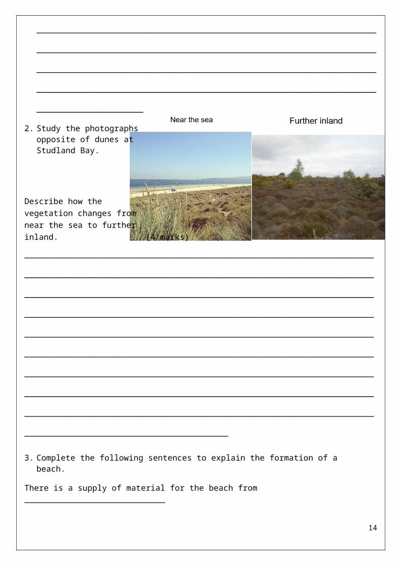
2. Study the photographs opposite of dunes at Studland Bay.
Describe how the vegetation changes from near the sea to further inland. (4 marks)______________________________________________________________________________________________________________________________________________________________________________
11

____________________________________________________________________________________________________________________________________________________________________________________________________________________________________________________________________________________________________________________________________________________________________________________________________________________________________________________________________________________________________________________________________
3. Complete the following sentences to explain the formation of a beach.
There is a supply of material for the beach from _____________________________
_________________________________________________________________
Beaches are formed by the process of deposition. This means ___________________
_________________________________________________________________
Beaches are found in bays because _______________________________________
_________________________________________________________________
Constructive waves lead to the formation of beaches because ___________________ _________________________________________________________________
12

Mappleton: Coastal Management case studyUse the images to explain why this area needs protecting._________________________________________
_________________________________________
_________________________________________
_________________________________________
_________________________________________
_________________________________________
_________________________________________
Categorise thedifferent information about Mappleton into causes of erosion, costs and benefits of sea defences.
13
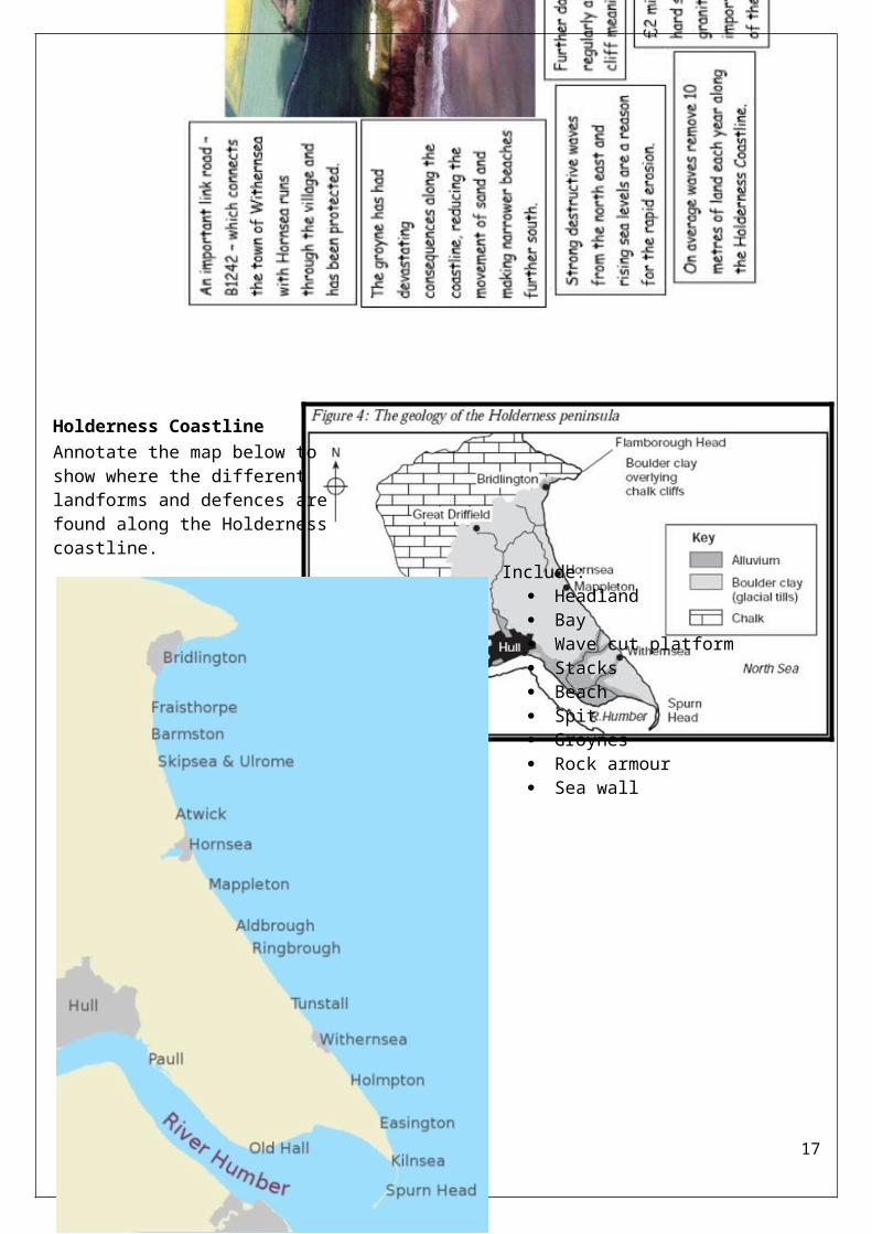
Holderness CoastlineAnnotate the map below to show where the different landforms and defences are found along the Holderness coastline.Include:
Headland Bay Wave cut platform
Stacks Beach Spit Groynes Rock armour Sea wall
14

Exam Practice1. Suggest how the sea defences
shown in help to protect the coastline. [4 marks]
_____________________________________________________________________________________________________________________________________________________________________________________________________________________________________________________________________________________________________________________________________________________________________________________________________________________________________________________________________________________________________________________________________________________________________________________________________________________________________________________
2. Suggest why the coastal area shown in needs to be protected from the effects of physical processes. [4 marks]__________________________________________________________________________________________________________________________________________________________________________________________________________________________________________________________________________________________________________________________________________________________________________________________________________________________________________________________________________________________________________________________________________________________________________________
3. Explain how soft engineering is used to protect coastlines from the effects of physical processes. (4 marks)
15

______________________________________________________________________________________________________________________________________________________________________________________________________________________________________________________________________________________________________________________________________________________________________________________________________________________________________________________________________________________________________________________________________________________________________________________________________________________________________________________________________________________________
4. “Hard engineering strategies are effective in protecting the coastline”Do you agree with this statement? Explain your answer. (6 marks)__________________________________________________________________________________________________________________________________________________________________________________________________________________________________________________________________________________________________________________________________________________________________________________________________________________________________________________________________________________________________________________________________________________________________________________________________________________________________________________________________________________________________________________________________________________________________________________________________________________________________________________________________________________________________________________________________________________________________________
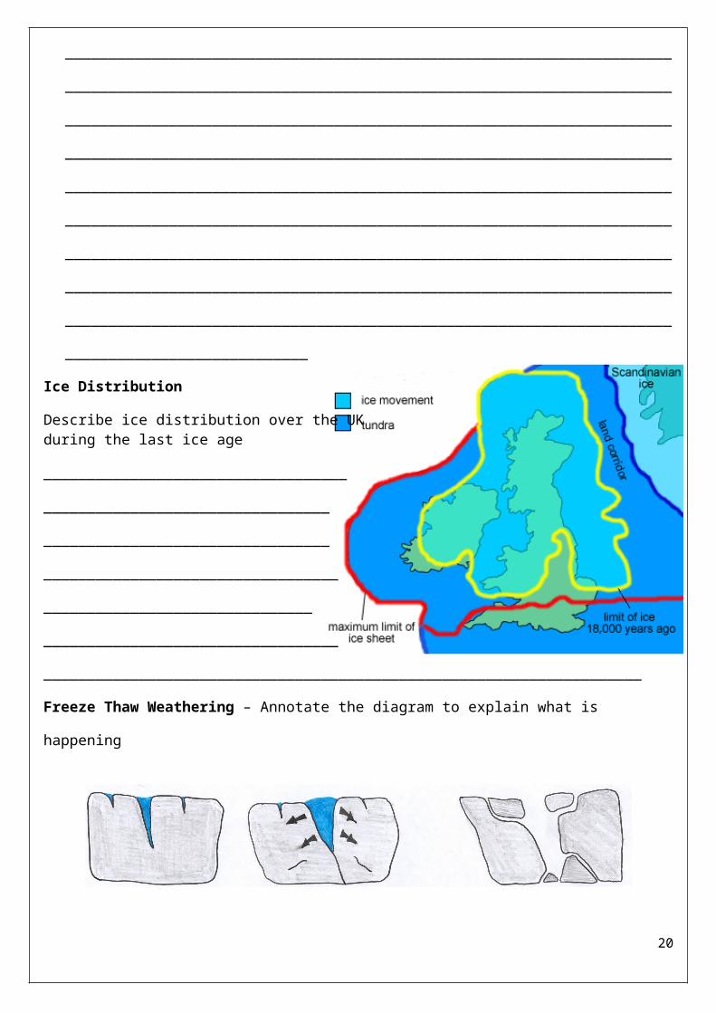
Ice DistributionDescribe ice distribution over the UK during the last ice age________________________________________________________________________________________________________________________________________________________________________________________________________
16
_____________________________________________________________________Freeze Thaw Weathering – Annotate the diagram to explain what is happening
Ice Erosion ProcessesExplain how plucking occurs?_________________________________________________________________________________________________________________________________________________________________________________________Explain the process of abrasion._______________________________________________________________________________________________________________________________________________________________________________________________________________
Outwash PlainAnswer the following questionsWhere is the outwash plain of a glacier located?____________________________
Where has the water come from?____________________________
Where has the deposited material (till) that is here come from?_____________________________________________________________________
17

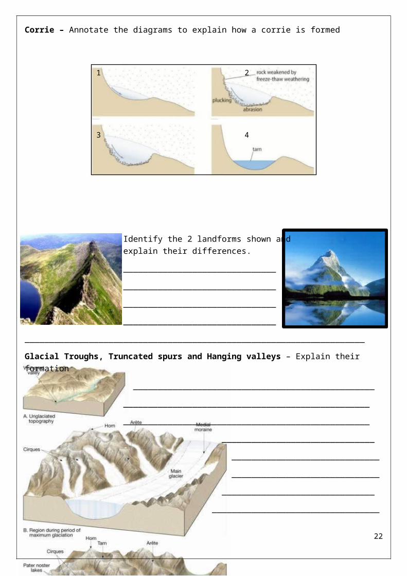
Why is this material rounder and smoother?__________________________________________________________________________________________________________________________________________Erosional LandformsCorrie – Annotate the diagrams to explain how a corrie is formed
Identify the 2 landforms shown and explain their differences.____________________________________________________________________________________________________________________________
_____________________________________________________________________Glacial Troughs, Truncated spurs and Hanging valleys – Explain their formation
_____________________________________________________________________________________________________________________________________________________
_______________________________ ______________________________ _____________________________________________________________
______________________________________________________________________
18
1 2
3 4

________________________________________________________________________
______________________________ ____________________________________________________________________________________________
_____________________________________________________________________________________________________________________________________________________________________________________________________________________________________________________________________________________________________________________________________________________________________________________________Exam Practice1. The following paragraph describes how glacial processes shape the landscape in
upland areas.Complete the paragraph. Choose the correct words from the list below.
abrasion plucking weathering[2 marks]
In upland areas, the effects of freeze-thaw ………………………………. can be significant.
As ice moves over the land it can rip material out of the ground. This type of erosion is
called ………………………..……. . Moving glaciers often carry fragments of rock which
smooth the bedrock by a process of …….…………………..……. .
2. Suggest a reason why there is an area of flat landseparating Lake Buttermere and Crummock Water, shown as Y. [1 mark]__________________________________________________________________________________________
Explain the formation of a glacial trough. (4 marks)____________________________________________________________________________________________________________________________________________________________________________________________________________________________________________________________________________________________________________________________________________________________
19
_________________________________________________________________________________________________________________________________________________________________________________________________________________________________________________________________________________
3. Suggest why the rock in the foreground of the photograph is fractured. (2 marks)__________________________________________________________________________________________________________________________________________________________________________________________________________________Identify 1 landform shown in the photograph. (1 mark) __________________________Explain the formation of this landform. (4 marks)
__________________________________________________________________________________________________________________________________________________________________________________________________________________________________________________________________________________________________________________________________________________________________________________________________________________________________________________________________________________________________________________________________________________________________________________________________________________________________________________________________________________________________________________
4. Which landform is located in grid square 1519? (1 mark)
What is the height difference between Grasmoor (V) and the edge of Crummock Water (W)?
20

Ribbon Lakes – Add annotations to each arrow to explain how a ribbon lake forms
Depositional LandformsDescribe an erratic. ________________________________________________________________________________________________________
Drumlins – Explain their formation______________________________________________________________________________________________________________________________________________________________________________________________________________________________________________________________________________________________________________________________________________________________________________________________________________________________________________________________________________________________________________________________________________________________Moraines – Explain the formation of…Lateral: ____________________________________________________
21
______________________________________________________________________________________________________________________________________________________________________________Medial: ______________________________________________________________________________________________________________________________________________________________________________________________Terminal: ________________________________________________________________________________________________________________________________________________________________________________________________________Economic activates in glaciated areas – Lake DistrictActivity Why is this an economic
opportunity?How might this create conflict with other land users?
Tourism
Sheep farming
Forestry
Quarrying
Exam Practice1. Study the diagram showing the features produced by glaciation.
Complete the diagram by using the following terms: (3 marks)
Corrie Drumlin Hanging valley Pyramidal peak
22

2. Explain the formation of depositional landform(s) shown in Figure 16. (6 marks)__________________________________________________________________________________________________________________________________________________________________________________________________________________________________________________________________________________________________________________________________________________________________________________________________________________________________________________________________________________________________________________________________________________________________________________________________________________________________________________________________________________________________________________________________________________________________________________________________________________________________________________________________________________________________________________________________________________________________________
3. Explain how glaciated landscapes provide opportunities for economic activities. (4 marks)____________________________________________________________________________________________________________________________________________________________________________________________________________________________________________________________________________________________________________________________________________________________________________________________________________________________________
23

__________________________________________________________________________________________________________________________________________________________________________________________________________________________________________________________
4. Suggest why land use conflicts might occur in glaciated upland areas. [4 marks]______________________________________________________________________________________________________________________________________________________________________________________________________________________________________________________________________________________________________________________________________________________________________________________________________________________________________________________________________________________________________________________________________________________________________________________________________________________________________________________________________________________________
Tourism in a glaciated upland area – Lake DistrictWhat attracts people to the Lake District? (Remember to be specific – The geography of somewhere not anywhere)
What the impacts of tourism in the Lake District? – Categorise into positive and negatives and then into social, economic and environmental.
Sustainable management strategies – Complete the tableStrategy What is it? How will this solve a problem created by
24
Tourism provides employment and income for local people and businesses.
Public have access to beautiful scenery of UKEmployment can be seasonal and wages low.
Water sports cause erosion of lake shores and there can be conflicts of interests between different lake users.
Key
Positive Negative
Social Economic Environmental
Tourism brings in vital income to the area. It is estimated that tourists spend £925 million per year.
People choose to stay in the area, which maintains other essential services such as schools and hospitalsServices provided for the use of tourists, e.g. leisure facilities, also benefit local people.
15% of homes in the Lake District are second homes of holiday lets, and new homes are rarely built this means that house prices have risen dramatically.
Congestion Over 89% of visitors come by car, often for the day. Many roads are narrow and winding. Buses and large delivery vehicles have to use these to service both locals and tourists. Queues are a common problem.
Footpath erosion occurs because of the sheer numbers of people using popular routes. According to the Park Authority, 4 million people walk an average of 6km each year.
Towns and villages are overrun by tourists. Many people believe that the Lake District has lost its identity.
Approximately 50% of the workforce in both the Windermere and Keswick areas are employed in hotels, catering and tourism related trades (compared to 6% nationally).

tourism?
Improved parking
Reduced footpath erosion
Reduced traffic
congestion
Protecting the
environment
Exam Practice1. Using the photographs suggest how tourism might put
pressure on glaciated upland areas. (4 marks)________________________________________________________________________________________________________________________________________________________________________________________________________________________________________________________________________________________________________________________________________________________________________________________________________________________________________________________________________________________________________________________________________________________________________________________________________________________________________________________________________________
2. ‘The growing number of visitors to glaciated upland areas in the UK can only bring advantages.’
25

Do you agree? Use an example to explain your answer. [6 marks] _____________________________________________________________________________________________________________________________________________________________________________________________________________________________________________________________________________________________________________________________________________________________________________________________________________________________________________________________________________________________________________________________________________________________________________________________________________________________________________________________________________________________________________________________________________________________________________________________________________________________________________________________________________________________________________________________________________________________________________________________________________________________________________
26