the vascular flora of mason mountain wildlife management area
TRANSCRIPT
2007 SOUTHEASTERN NATURALIST 6(4):683-692
The Vascular Flora of Mason Mountain Wildlife
Management Area, Mason County, Texas
Jason R. Singhurst '
, Laura L. Sanchez2, Donnie Frels, Jr.3,
T.Wayne Schwertner4, Mark Mitchell4, Sara Moren5, and Walter C. Holmes6
Abstract - A survey of the vascular flora of Mason Mountain Wildlife Management
Area, located in the Llano Uplift of Central Texas, was conducted between spring of 2001 and spring of 2006. A total of 693 species and infraspecific taxa in 103 families and 376 genera were documented from 14 plant associations. Poaceae (117 species),
Asteraceae (102 species), Fabaceae (46 species), and Euphorbiaceae (31 species) were the families with the largest number of species. Five taxa, Campanula
reverchonii (basin bellflower), Eriogonum tenellum Torr. var. ramosissimum (tall
buckwheat), Isoetes lithophila (rock quillwort), Packera texensis (Llano groundsel), and Tradescantia pedicellata (Edwards Plateau spiderwort) are endemic to the Llano
Uplift, while 24 others are endemic to Texas. Other noteworthy taxa included Isoetes
piedmontana (Piedmont quillwort), Pilularia americana (American pillwort), and
Senecio ampullaceus (Texas ragwort).
Introduction
The Llano Uplift (Gould 1975, Lyndon B. Johnson School of Affairs
1978) of Texas comprises about 12,950 km2 (5000 mi2) of gently rolling to hilly lands that lie to the west of Austin and encompasses portions of
Blanco, Burnet, Gillespie, Kimble, Llano, Lampasas, Mason, Menard, Mc
Culloch, San Saba, and Travis counties. The study area is located in the eastern portion of the Edwards Plateau vegetation area of the state and is
characterized by granite outcrops. Correll and Johnston (1970) describe
the Edwards Plateau as a region of significant endemism; however, the
granite-outcrop portion of this region has received limited botanical ex
ploration over the past 150 years. Some of the first efforts to describe
these outcrops' flora were by Lindheimer (Geiser 1948), who made two
collecting trips to the Llano Uplift in 1847-48, and Reverchon, who made
the first extensive collections in the region in 1885-86. Others included
Whitehouse (1933), Roemer (1849), Butterwick (1979), and Walters and
Wyatt (1982). These studies were mostly concentrated on an area centered
on present day Enchanted Rock State Park in Llano County. Mason County was not included. The general lack of botanical study in the Llano Uplift
1Wildlife Diversity Program, Texas Parks and Wildlife Department, 3000 South IH-35, Suite 100, Austin, TX 78704.29 Clearwater Drive, Morgans Point, TX 76513. 3Kerr
Wildlife Management Area, Texas Parks and Wildlife Department, 2625 FM 1340, Hunt, TX 78024. 4Mason Mt. Wildlife Management Area, Texas Parks and Wildlife
Department, Mason, TX 76856.5Lopezgarcia Group, 7004 Bee Caves Road, Building
1, Suite 205, Austin, TX 78746. department of Biology, Baylor University, Waco, TX 76798-7388. "Corresponding author [email protected].
This content downloaded from 204.64.0.171 on Thu, 6 Feb 2014 16:42:00 PMAll use subject to JSTOR Terms and Conditions

684 Southeastern Naturalist Vol. 6, No. 4
and specifically Mason County is reflected by the low number of plant col
lections represented in University of Texas Plant Resources Center's Flora
of Texas database (2006). This database cites only 378 collections from
Mason County out of approximately 250,000 records for the state. The low
number of collections is undoubtedly due to the high percentage of land in
private ownership that is mostly unavailable for scientific study. In 1997, Mr. CG. Johnson donated to the State of Texas the area now
known as the Mason Mountain Wildlife Management Area (MMWMA), a gift that consisted of approximately 2147 ha (5304 ac) located about 10
km northwest of Mason in Mason County. Today, MMWMA is the largest
publicly owned property on the Llano Uplift. Prior to acquisition, the area
was a working ranch that primarily raised exotic ungulates for hunting and
for breeding stock. The area is currently divided into seven pastures by 2.4
m high fences. Among the non-native ungulates present are Tragelaphus
strepsiceros Pallas (greater kudu), Oryx gazella Gray (gemsbok) and nine
others. Odocoileus virginianus Zimmermann (white-tailed deer) is the only native ungulate. Presently, the specific mission of MMWMA is to man
age natural resources of the area in a holistic, ecosystem process-oriented
philosophy. To accomplish this goal, Texas Parks and Wildlife Department
(TPWD) has implemented a public hunting program and also offers limited
public access for natural interpretation and restoration events. In an effort
to reduce the population of exotics and generate revenue, a program of
aggressive hunting and selling of exotic ungulates has been implemented (Schwertner 1998).
The present study is part of an effort by TPWD to enumerate the flora of
lands under their authority (see Fleming et al. 2002, Singhurst et al. 2003). The
specific objectives of this research were to compile an annotated checklist of
the flora of MMWMA, determine if plants of special concern are present, and
provide a qualitative description of the plant communities of the area.
Materials and Methods
The checklist (shown in Supplementary Appendix 1. Available only online at http://dx.doi.org/10.1656/S497.sl) has been compiled largely from
specimens collected between summer of 1998 and fall of 2005. Vouchers were made for all species except for a few cacti that were photographed with a digital camera for identification. Nomenclature follows Jones et al.
(1997), Turner et al. (2003), and United States Department of Agriculture
(2005). Plant specimens were deposited at Baylor University Herbarium
(BAYLU) and Mason Mountain Wildlife Management Area Herbarium
(herein referred to as MMWMA). All duplicate specimens were sent to the
University of Texas Herbarium (TEX-LL). The flora of Texas database of
the University of Texas Plant Resources Center (TEX-LL), (2006) and the
Herbarium Specimen Browser of Texas A&M University (both TAES and
TAMU), College Station (2006), was examined for additional records. This,
however, yielded minimal results because the study area was generally not
This content downloaded from 204.64.0.171 on Thu, 6 Feb 2014 16:42:00 PMAll use subject to JSTOR Terms and Conditions
2007 J.R. Singhurst et al. 685
available for botanical study while privately owned, and thus few herbarium
specimens were collected there before 1999.
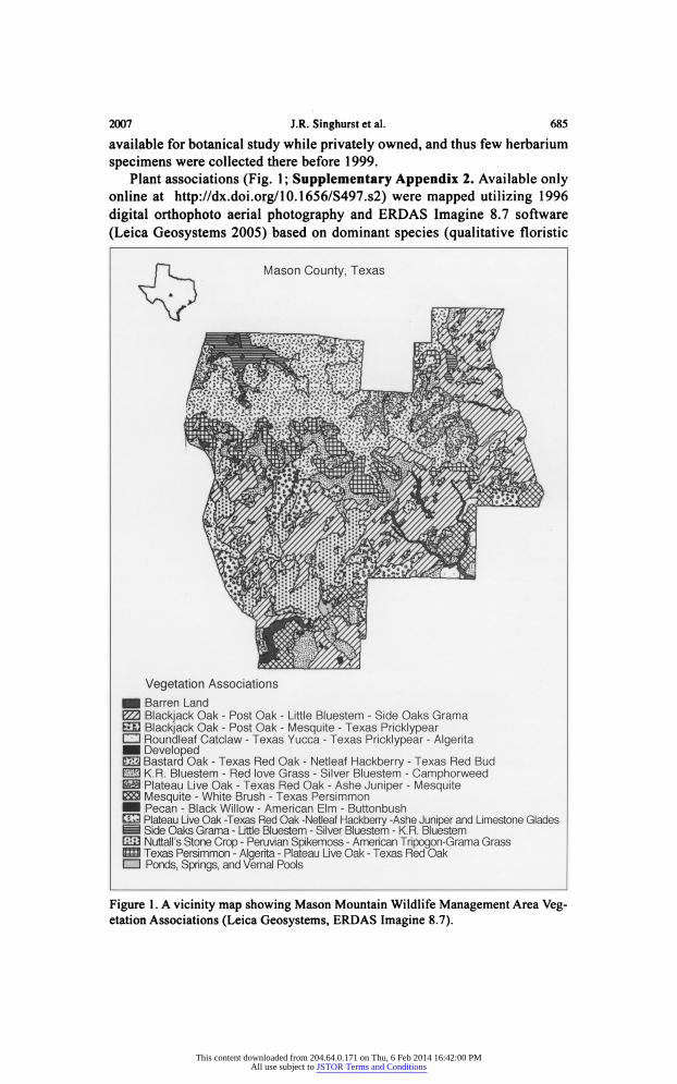
Plant associations (Fig. 1 ; Supplementary Appendix 2. Available only online at http://dx.doi.org/10.1656/S497.s2) were mapped utilizing 1996
digital orthophoto aerial photography and ERDAS Imagine 8.7 software
(Leica Geosystems 2005) based on dominant species (qualitative floristic
Figure 1. A vicinity map showing Mason Mountain Wildlife Management Area Veg etation Associations (Leica Geosystems, ERDAS Imagine 8.7).
This content downloaded from 204.64.0.171 on Thu, 6 Feb 2014 16:42:00 PMAll use subject to JSTOR Terms and Conditions
686 Southeastern Naturalist Vol. 6, No. 4
inventories), landscape position (utilizing digital raster graphic elevation
lines), and digital soils (Natural Resource Conservation Service 2006). So
renson's Index (Jongman et al. 1995, Sorensen 1948) was used to compare floristic similarity between MMWMA and Enchanted Rock State Natural
Area (O'Kennon 1993), a 655-ha. (1643-ac) granite dome complex located
in Llano County, TX, approximately 64 km (40 mi) southeast of the study area. Sorenson's Index is calculated as: 2C / (A + B), where C is the num
ber of shared taxa, A is the number of taxa in sample one, while B is the
number in sample two. The focus of this analysis is to compare the ecology relation or resemblance between the two largest conservation tracts of land
on the Llano Uplift. A plant association is defined as an assemblage of definite floristic
composition, presenting a uniform physiognomy, and growing in uni
form habitat conditions (Flahault and Schr?ter 1910). In this sense, the
association concept applies to existing vegetation regardless of succes
sional status. The plant associations are arranged into terrestrial, aquatic,
disturbed, and barren or developed systems, which are further subdivided
into natural and disturbed types. The natural types of both terrestrial and
aquatic systems are further subdivided into units based upon the underly
ing geology, this being sandstone, igneous, or limestone. Natural types are
characterized predominantly by woody dominants that were presumed to
be remnants of the natural vegetation. Disturbed types that lack woody spe cies would be expected because of past or current land-use practices such
as tillage. Disturbed aquatic systems are referred to as artificial impound ments. Vernal pools within wetland types are defined as precipitation-filled seasonal wetlands inundated during periods when temperature is sufficient
for plant growth, followed by a brief waterlogged-terrestrial stage and
culminating in extreme desiccating soil conditions of extended duration
(Keeley and Zedler 1998).
Study Area
The MMWMA is located within the subtropical humid region of the
modified marine climate, an area of central Texas characterized by long, hot summers and mild winters (Bomar 1995). Based on data from a recent
100-yr. period, average annual precipitation is approximately 66 cm (26 in), with a maximum of 71 cm (28 in) and a minimum of 61 cm (24 in) (Hatch et al. 1990). Average annual temperature is approximately 18.8 ?C (Hatch et
al. 1990). The growing season is about 240 days, with the frost-free period
extending from April through October (Hatch et al. 1990). MMWMA is lo
cated on the northwest portion of the Llano Uplift and is characterized by
rolling terrain with elevation ranging from 518 m (1700 ft) to 621 m (2040
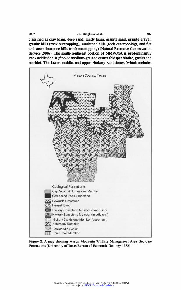
ft) (Hatch et al. 1990). The geology (Fig. 2) of the area is comprised of seven formations: do
lomite, granite, limestone, quartz, sand, sandstone, and shale. Soils are
This content downloaded from 204.64.0.171 on Thu, 6 Feb 2014 16:42:00 PMAll use subject to JSTOR Terms and Conditions
2007 J.R. Singhurst et al. 687
classified as clay loam, deep sand, sandy loam, granite sand, granite gravel,
granite hills (rock outcropping), sandstone hills (rock outcropping), and flat
and steep limestone hills (rock outcropping) (Natural Resource Conservation
Service 2006). The south-southeast portion of MMWMA is predominantly Packsaddle Schist (fine- to medium-grained quartz feldspar biotite, gneiss and
marble). The lower, middle, and upper Hickory Sandstones (which includes
Figure 2. A map showing Mason Mountain Wildlife Management Area Geologic Formations (University of Texas Bureau of Economic Geology 1982).
This content downloaded from 204.64.0.171 on Thu, 6 Feb 2014 16:42:00 PMAll use subject to JSTOR Terms and Conditions
688 Southeastern Naturalist Vol. 6, No. 4
lower, middle, and upper layers composed of quartz, silt, calcite, and massive
sandstone) are included within this formation. The Cap Mountain Limestone
(finely grained, distinctly jointed, and somewhat massive limestone) also oc
curs in the southeast corner of MMWMA as two small bluffs. Just north of
these is an extensive area of granite composed of Katemcy Batholiths (coarse
gravel and massive pink granite) that form the large hilly "domes" and include
a few small inclusions within the Packsaddle Schist. North of the Katemcy
Batholiths, two narrow bands of the Hensell Sand (fine-grained, poorly sorted, dolomitic sandstone) and Comanche Peak Limestone (fine grained, dolimi
tized) are exposed on steep slopes and in small canyons. Just to the north of the
Hensell Sand and Comanche Peak Limestone is an Edwards Limestone (fine
grained, dolimitized, and chert nodules) mesa, which is the highest point in
the property. The preceding summary of the geology, which is discussed from
south-southeast to north-northwest, is extracted from the University of Texas
Bureau of Economic Geology (1982).
Results
The MMWMA flora (Supplementary Appendix 1. Available only online
at http://dx.doi.org/10.1656/S497.sl) consists of 693 species and infraspe cific taxa in 103 families and 376 genera. Ferns and fern allies constituted 20
species, gymnosperms 1, monocots 184, and dicots 488. The largest families
were Poaceae (117), Asteraceae (102), Fabaceae (46), and Euphorbiaceae
(31). Other families with a significant number of species included Cypera ceae (30), Lamiaceae (17), Brassicaceae (17), Scrophulariaceae (14), and
Apiaceae (13). Genera with the largest number of species are Cyperus (12),
Eragrostis (11), Panicum (10), and Crot?n (9). Introduced species (59) rep resent 8.51% of the total flora, of which 23 were in the Poaceae. Five highly restricted Llano Uplift endemics (Carr 2002, 2005) that are ranked as spe cial plants of concern (Nature Serve 2006) occur at MMWMA. These are
Campanula reverchonii Gray (basin bellflower; G2S2), Eriogonum tenellum
Torr. var. ramosissimum Benth. (tall buckwheat; G5T3), Isoetes lithophila N.E. Pfeiffer (rock quillwort; G2S2), Packera texensis R.J. O'Kennon and
D.K. Trock (Llano groundsel ; G2S2), and Tradescantiapedicellata Celarier
(Edwards Plateau spiderwort; G2S2). More widespread Texas endemic taxa
that were abundant at MMWMA include Astragalus pleianthus (Shinners)
Isely (Edwards Plateau milkvetch), Castilleja purpurea (Nutt.) G. Don var.
lindheimeri (Gray) Shinners (Lindheimer's Indian paintbrush), Chaetopappa
bellidifolia (Gray & Engelm.) Shinners (whiteray leastdaisy), Chamaesyce
angusta (Engelm.) Small (blackfoot sandmat), Cheilanthes kaulfussii Kunze
(Kaulfuss' lipfern), Croptilon hookerianum (Torr. & Gray) House var. hooke
rianum (Hooker's scratchdaisy), Euphorbia roemeriana Scheele (Roemers's
spurge), Galactia texana (Scheele) Gray (Texas milkpea), Indigofera min
iata var. texana (Buckl.) B.L. Turner (Texas indigo), Lechea san-sabeana
(Buckl.) Hodgdon (San Saba pinweed), Lesquerella densiflora (Gray) S.
Wats, (denseflower bladderpod), Muhlenbergia lindheimeri A.S. Hitchc.
This content downloaded from 204.64.0.171 on Thu, 6 Feb 2014 16:42:00 PMAll use subject to JSTOR Terms and Conditions
2007 J.R. Singhurst et al. 689
(Lindheimer's muhly), Nolina lindheimeriana (Scheele) S. Wats, (devil's
shoestring), Parthenocissus heptaphylla (Buckl.) Britt. ex Small (sevenleaf
creeper), Phlox pilosa subsp. latisepala Wherry (downy phlox), P. roemeri
ana Scheele (goldeneye phlox), Silphium albiflorum Gray (white rosinweed),
Tephrosia lindheimeri Gray (Lindheimer's hoarypea), Tradescantia ed
wardsiana Tharp (plateau spiderwort), Triodanis texana McVaugh (Texas Venus' looking-glass), Vitis mont?cola Buckl. (sweet mountain grape), and
Yucca rupicola Scheele (Texas yucca). Texas endemics restricted to a single mesic limestone canyon at MMWMA include Arabis petiolaris (Gray) Gray
(Brazos rockcress), Argythamnia aphoroides Muell.-Arg. (Hill Country sil
verbush), and Matelea edwardsensis Correll (plateau milkvine). There are
several other noteworthy species. Isoetes piedmontana Piedmont (quillwart) is known in Texas from this study area and two sites in Llano County (Hol
mes et al. 2005). The species also occurs in Alabama, Georgia, North Caro
lina, South Carolina, and Virginia (Holmes et al. 2005). Pilularia americana
A. Braun (American pillwort) is restricted to a few granite and limestone
vernal pools and shallow ponds in Burnet, Llano, Mason, and Wise counties
in Texas (K. McLemore and R.J. O'Kennon, Botanical Research Institute of
Texas, Fort Worth, pers. comm.; Turner et al. 2003). American pillwort oc
curs in one shallow pond at MMWMA. Also present is Senecio ampullaceus Hook. (Texas groundsel), endemic to the West Gulf Coastal Plains (Sorrie and Weakly 2001), which is at the western limits of its distribution. A few
eastern plants also reach their southern and western-most known distribu
tion at MMWMA and include Fimbristylis puberula (Michx.) Vahl var. inte
rior (Britt.) Krai (hairy fimbry), Juncus diffusissimus Buckl. (slimpod rush),
Lepuropetalon spathulatum Ell. (petiteplant), and Rumex hastatulus Baldw.
(heartwing sorrel). O'Kennon (1993) recorded a total of 555 species at the much smaller En
chanted Rock State Natural Area (ERSNA), with 37 being introduced. The
park consists of two granite domes (Enchanted Rock dome and Little Rock
dome) and a large canyon between the domes. The canyon is largely shaded
and remains moist for most of the year, thus supporting many shade and seep
species that do not occur at MMWMA. The park also has more surface seeps and spring contacts than are present at MMWMA. ERSNA has 555 species recorded and MMWMA has 693 species, with 367 species common to both areas. The similarity index for the two areas is:
IS = 2C/(A + B) = 2(367) / (555 + 693)
= 0.588
Discussion
MMWMA is a floristically diverse landscape that currently cites
the highest number of plant taxa (693 species and infraspecific taxa) documented for a defined area within the Llano Uplift. This number is 27%
of the species recorded within the Edwards Plateau by Stanford (1976).
This content downloaded from 204.64.0.171 on Thu, 6 Feb 2014 16:42:00 PMAll use subject to JSTOR Terms and Conditions
690 Southeastern Naturalist Vol. 6, No. 4
MMWMA also has a low number of non-native plants (59 of 693 species), which is 8.51% of the flora documented. For comparative purposes, ERS
NAhas 37 non-native plants (6.7%) of the 555 species reported (O'Kennon
1993). Thirty species occurring at MMWMA are listed as Texas endemic
plants (Carr 2002, 2005; Nature Serve 2006). Travis and Bexar counties, which lie on the east and southeast edge of the Llano Uplift, have the high est number of Texas endemics, with 89 and 85 respectfully (Flora of Texas
Consortium 1996). This, in part, seems related to their larger size and that
they lie within four of the ten vegetational areas of the state. In compari son, Mason County has 50 Texas endemics, while adjacent Llano County has 39 endemic plants recorded (Flora of Texas Consortium 1996), but both
lie fully within one vegetational region (Edwards Plateau). In further com
parison of MMWMA with ERSNA, MMWMA contains 30 endemic plants
(60.0% of the endemics documented for Mason County), whereas ER
SNA has 21 endemic plants (53.8% of the endemics documented for Llano
County). In addition, the similarity index value (0.588) for these two areas
in the same ecoregion appears low. This low value could, in part, be related
to the size of the areas or more likely to the presence of the limestone plant
community associations at MMWMA.
MMWMA is also a strikingly complex site, with 12 natural or
semi-natural plant community associations (Fig. 1; Supplementary
Appendix 2. Available only online at http://dx.doi.org/10.1656/S497.s2). The study resulted in the discovery of two plant community associations
(Supplementary Appendix 1. Available only online at http://dx.doi.org/
10.1656/S497.sl) not previously documented in Texas, but known in
Oklahoma, which is approximately 400 km to the north. Additionally, two
newly described associations, which are apparently limited to Texas, were
discovered and documented.
While the present work contributes to the botanical knowledge of the
state, it can only serve as an invitation for additional botanical study of this
very interesting geological area of Texas.
Acknowledgments
We are grateful to Texas Parks and Wildlife Department (TPWD), Austin, TX, staff members who facilitated this research. Ron George made funds available for the
Wildlife Diversity Program for the botanical inventories and geographic information science systems development on MMWMA. Paul Robertson (formally with TPWD, now with The Nature Conservancy of Colorado) and John Herron (formerly with
TPWD, now with The Nature Conservancy of Texas) assisted by designating the
project as a Wildlife Diversity Program performance priority.
Tom Wendt and Lindsey Woodruff at TEX-LL Herbarium, University of Texas, as
sisted with specimen identification. Bill Carr of The Nature Conservancy of Texas was
extremely helpful in introducing us to the Llano Uplift and determining several plant collections. Edwin Bridges (Botanical and Ecological Consultants in Bremerton, WA) graciously reviewed and provided suggestions on the manuscript. We would also like
to thank the many others mentioned in the annotated list of vascular plants who assisted
This content downloaded from 204.64.0.171 on Thu, 6 Feb 2014 16:42:00 PMAll use subject to JSTOR Terms and Conditions
2007 J.R. Singhurst et al. 691
with field collections. Dr. Jack Stanford played a crucial role in making early collec tions and identification of specimens at MMWMA Herbarium.
Literature Citation
Bomar, G.W. 1995. Texas Weather. University of Texas Press, Austin, TX. 275 pp.
Butterwick, M. 1979. A survey of the flora of Enchanted Rock and vicinity, Llano and
Gillespie counties, Texas. In D. Kennard (Ed.). Enchanted Rock, a Natural Area
Survey No. 14. LBJ School of Public Affairs, University of Texas, Austin, TX.
Carr, W.R. 2002. Plant taxa endemic to the State of Texas. The Nature Conservancy of
Texas, San Antonio, TX. 11 pp. Unpubl. report.
Carr, W.R. 2005. No place but Texas: An annotated list of plant taxa endemic to the
Lone Star State. The Nature Conservancy of Texas, San Antonio, TX. Unpub
lished report. Correll, D.S., and M.C. Johnston. 1970. Manual of the Vascular Plants of Texas.
Texas Research Foundation, Renner, TX. 1881 pp.
Flahault, C, and C. Schroter. 1910. Rapport sur la nomenclature phytogeographique.
Proceedings of the 3rd International Botanical Congress, Brussels, 1910, 1:
131-164.
Fleming, K., J.R. Singhurst, and W.C. Holmes. 2002. Vascular flora of Big Lake Bot
tom Wildlife Management Area, Anderson County, Texas. Sida 20(1):355?371. Flora of Texas Consortium. 1996. Vascular plants endemic to Texas. Available online
at http://www.csdl.tamu.edu/FLORA/endemics/endemicl .htm. January 2006.
Geiser, S.W. 1948. Naturalists of the Frontier. Second Edition. Southern Methodist
University Press, Dallas, TX. 296 pp.
Gould, F.W. 1975. Texas plants. A Checklist and Ecological Summary. 1975 Revi
sion. Texas Agricultural Experiment Station, College Station, TX. 121 pp.
Hatch, S.L., K.N. Gandhi, and L.E. Brown. 1990. Checklist of the Vascular Plants of
Texas. Texas Agricultural Experiment Station, Texas A&M University, College
Station, TX. 158 pp.
Holmes, W.C, A.E. Rushing, and J.R. Singhurst. 2005. The Genus Isoetes (Isoeta
ceae) in Texas. Lundellia 8:1-6.
Jones, S.D., J.K. Wipff, and P.M. Montgomery. 1997. Vascular Plants of Texas. Uni
versity of Texas Press, Austin, TX. 404 pp.
Jongman, R.G., CF. Ter Braak, and O.R. Van Tongeren. 1995. Data Analysis in Commu
nity and Landscape Ecology. Cambridge University Press, New York, NY. 299 pp.
Keeley, J.E., and P.H. Zedler.1998. Characterization and Global Distribution of
Vernal Pools .Pp. 1-14, In C.W. Witham, E.T. Bauder, D. Belk, W.R. Ferren, Jr.,
and R. Ornduff (Eds.). Ecology, Conservation, and Management of Vernal Pool
Ecosystems?Proceedings from the 1996 Conference. California Native Plant
Society, Sacramento, CA. 1998.
Leica Geosystems. 2005. Imagine Sofware, Version 8.7 Available online at http:
//www.leica-geosystems.com/. Accessed January 2006. Heerbrugg, Switzerland.
Lyndon B. Johnson School of Public Affairs. 1978. Preserving Texas' Natural Heri
tage. Lyndon B. Johnson School of Public Affairs Policy Research Project Report 31, University of Texas Austin, TX. 34 pp.
Nature Serve 2006. Nature Serve explorer database. Available online at http://
www.natureserve.org/. Accessed January 2006. Arlington, VA.
This content downloaded from 204.64.0.171 on Thu, 6 Feb 2014 16:42:00 PMAll use subject to JSTOR Terms and Conditions
692 Southeastern Naturalist Vol. 6, No. 4
Natural Resource Conservation Service. 2006. Digital soil database. Available online
at http://soildatamart.nrcs.usda.gov/. January 2006. National Cartography and
Geospatial Center, Ft. Worth, TX.
O'Kennon, R.J. 1993. Checklist for the flora of Enchanted Rock State Park. Texas
Parks and Wildlife Department, Austin, TX. 6 pp. Unpubl. report.
Roemer, F. 1849. Texas with Particular Reference to German Immigration and the
Physical Appearance of the Country. Translated from the German by O. Mueller,
Standard Printing Company, San Antonio, TX., Reprinted 1983 by the German Texan Heritage Society, Texian Press, Waco, TX.
Schwertner, T.W. 1998. Mason Mountain wildlife management plan: Long-range
management plan. Texas Parks and Wildlife Department, Austin, TX. 118 pp.
Unpubl. report.
Singhurst, J.R., J.C Cathy, D. Prochaska, H. Haucke, G.C Kroh,and WC Holmes.
2003. Vascular flora of Gus Engeling Wildlife Management Area, Anderson
County, Texas. Southeastern Naturalist. 2(3):247-368.
Sorrie, B.A., and A.S. Weakley. 2001. Coastal Plain vascular plant endemics: Phyto
geographic patterns. Castanea 66:50-82.
Sorensen, T. 1948. A method of establishing groups of equal amplitude in plant soci
ology based on similarity of species content. Det. Kong. Danske Videnshabernes
Selskabs Bekientgiorelse, Copenhagen. (4): 1-34.
Stanford, J.W 1976. Keys to the Vascular Plants Edwards Plateau and Adjacent Ar
eas. Howard Payne University, Brownwood, TX. 365 pp.
Texas A&M University. 2006. Herbarium specimen browser. Available online at
http://www.csdl.tamu.edu/FLORA/tracy/mainl.html. Accessed January 2006.
College Station, TX. The Nature Conservancy. 1997. National Vegetation Classification System: Okla
homa-Texas subset. 1997. The Nature Conservancy, Conservation Science De
partment, Southeast Region, Chapel Hill, NC. 217 pp.
Trock, D.K., and R.J. O'Kennon. 2003. A new species of Packera (Asteraceae: Se
necioneae) from the Edwards Plateau of Texas. Sida 20:945-952.
Turner, B.L., H. Nichols, G. Denny, and O. Doron. 2003. Atlas of the Vascular Plants
of Texas. Sida, Bot. Miscellaneous. 24. Botanical Research Institute of Texas,
Ft. Worth.
United States Department of Agriculture, Natural Resource Conservation Ser
vice. 2005. The PLANTS database, Version 3.5. Available online at http: //plants.usda.gov. The Nature Conservancy 1997. National Plant Data Center,
Baton Rouge, LA.
University of Texas Bureau of Economic Geology. 1982. Purdy Hill sheet-map,
1:24,000. The University of Texas, Austin, TX.
University of Texas Plant Resources Center. 2006. Flora of Texas database. Avail
able online at http://129.ll6.69.198:427/Texas.html. Accessed January 2006.
Austin, TX.
Walters, T.W, and R. Wyatt. 1982. The vascular flora of granite outcrops in the
Central Mineral Region of Texas. Bulletin of the Torrey Botanical Club 109: 344-364.
Whitehouse, E. 1933. Plant succession on central Texas granite. Ecology 14:
391-405.
This content downloaded from 204.64.0.171 on Thu, 6 Feb 2014 16:42:00 PMAll use subject to JSTOR Terms and Conditions