the use of uas in teaching research and service at stephen
TRANSCRIPT

1
David Kulhavy, Daniel Unger, I-Kuai Hung and Yanli Zhang
Arthur Temple College of Forestry and Agriculture
Stephen F. Austin State University
The Use of UAS in Teaching Research and Service at Stephen F. Austin State University
“Society-ready Foresters”
Kulhavy, Unger, Hung, and Zhang, College of Forestry and Agriculture, Stephen F. Austin State University

2
Arthur Temple College of Forestry and Agriculture
Kulhavy, Unger, Hung, and Zhang, College of Forestry and Agriculture, Stephen F. Austin State University
“Our overall goal in the Bachelor of Science in Forestry (BSF) degree program at Stephen F. Austin State University (SFASU) is to produce foresters who are ‘society ready,’ i.e., capable of dealing effectively with the complex economic, ecological, and social issues involving forest resources today.”
“Our BSF graduates must be prepared to effectively enhance the integrity, stability and health of the environment through sustainable management, conservation, and protection of forests and natural resources.”
Arthur Temple College of Forestry and Agriculture
Kulhavy, Unger, Hung, and Zhang, College of Forestry and Agriculture, Stephen F. Austin State University
3
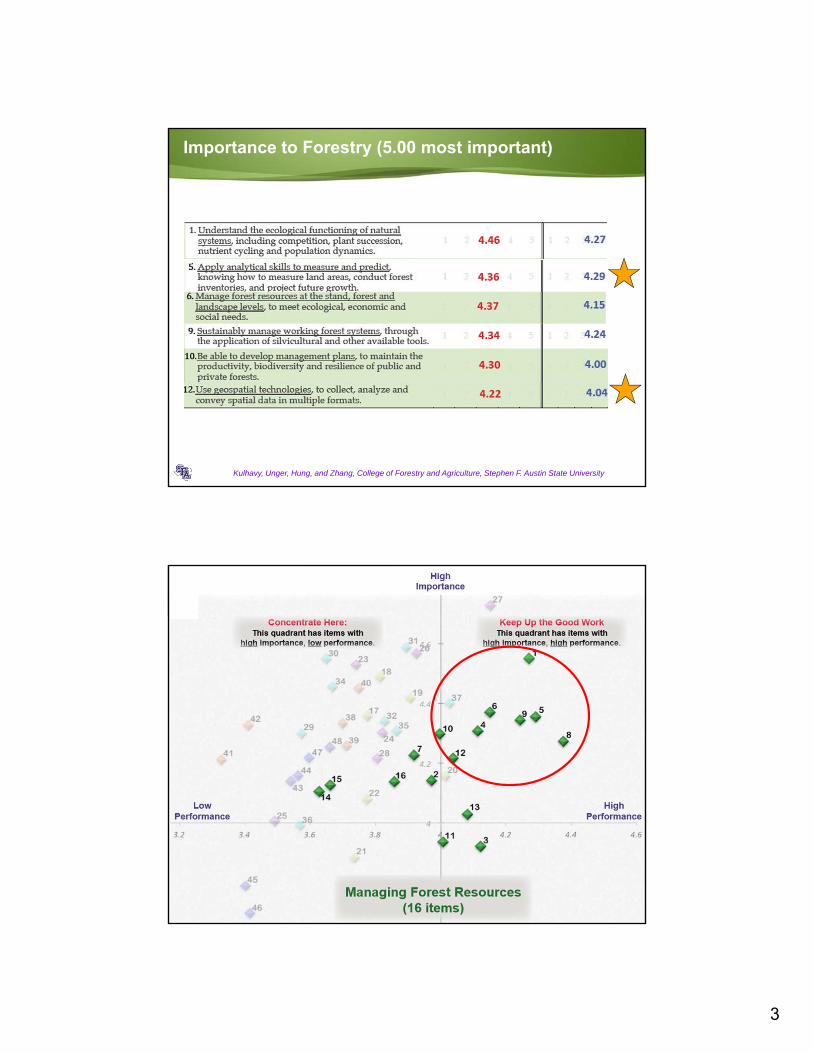
Importance to Forestry (5.00 most important)
Kulhavy, Unger, Hung, and Zhang, College of Forestry and Agriculture, Stephen F. Austin State University
Kulhavy, Unger, Hung, and Zhang, College of Forestry and Agriculture, Stephen F. Austin State University

4
Kulhavy, Unger, Hung, and Zhang, College of Forestry and Agriculture, Stephen F. Austin State University
Kulhavy, Unger, Hung, and Zhang, College of Forestry and Agriculture, Stephen F. Austin State University
Stephen F. Austin State University

5
Kulhavy, Unger, Hung, and Zhang, College of Forestry and Agriculture, Stephen F. Austin State University
Stephen F. Austin State University
Kulhavy, Unger, Hung, and Zhang, College of Forestry and Agriculture, Stephen F. Austin State University
Stephen F. Austin State University

6
Kulhavy, Unger, Hung, and Zhang, College of Forestry and Agriculture, Stephen F. Austin State University
Stephen F. Austin State University
Kulhavy, Unger, Hung, and Zhang, College of Forestry and Agriculture, Stephen F. Austin State University
Stephen F. Austin State University ForestryArthur Temple College of Forestry and Agriculture

7
Unmanned Aerial Systems: Where do we begin?
Training under FAA 336 for teaching/demonstrations
• Fly under 400 feet
• Line of sight
• Pilot in Command and Visual Observer
• Daytime
• Student involvement
Training course for FAA UAS Pilot Exam
• FAA 107 rule for UAS license
• 60 question test at FAA site; vetting by TSA
Kulhavy, Unger, Hung, and Zhang, College of Forestry and Agriculture, Stephen F. Austin State University
Horizontal Perspective
Arthur Temple College of Forestry and Agriculture, Stephen F. Austin State University

8
Vertical Perspective
TM – 30 meters
Arthur Temple College of Forestry and Agriculture, Stephen F. Austin State University
MSS – 79 meters
QB– 2.44 meters
Drone – ≥ 2.25 inches
Why SFA? Why Arthur Temple College of Forestry and Agriculture?
Arthur Temple College of Forestry and Agriculture, Stephen F. Austin State University

9
The Fleet of UAS at SFA Forestry, Environmental Science, Spatial Science
AR.Drone 2.0 (Parrot) (tree hazard rating)
Bebop UAS (Parrot) (tree hazard rating, trail condition, non-nadir)
DJI Phantom 3 (tree hazard rating, height validation, Ips and pine mortality)
DJI Phantom 4 (programmed flight, Drone2Map ArcGIS software)
DJI Spark (hazard ration, urban forestry)
Kulhavy, Unger, Hung, and Zhang, College of Forestry and Agriculture, Stephen F. Austin State University
Drone2Map for ArcGIS
Orthomosaics
Digital surface models
3D points clouds
3D meshes
Kulhavy, Unger, Hung, and Zhang, College of Forestry and Agriculture, Stephen F. Austin State University

10
Make it fly, safety, preflight check, log in flight
Planning and executing a flight plan; A to Z DJIGO Pix4D apps
Kulhavy, Unger, Hung, and Zhang, College of Forestry and Agriculture, Stephen F. Austin State University
Programmed flight, Pix4D, download to Drone2Mapinto ArcGIS 10.5.2 in the GIS Laboratory
80 percent endlap
60 percent sidelap
Set flight speed
Two pass flight
Download to Drone2Map
Can view individual frames
at 2.25 inch resolution from 400 feet
1 inch resolution at 200 feet
Kulhavy, Unger, Hung, and Zhang, College of Forestry and Agriculture, Stephen F. Austin State University

11
Get the hands on and see from above and the side
Demonstrations for Forestry
Spatial Science
Environmental Science
High Schools
Kulhavy, Unger, Hung, and Zhang, College of Forestry and Agriculture, Stephen F. Austin State University
Get the hands on and see from above and the side
Kulhavy, Unger, Hung, and Zhang, College of Forestry and Agriculture, Stephen F. Austin State University
12
Kulhavy, Unger, Hung, and Zhang, College of Forestry and Agriculture, Stephen F. Austin State University
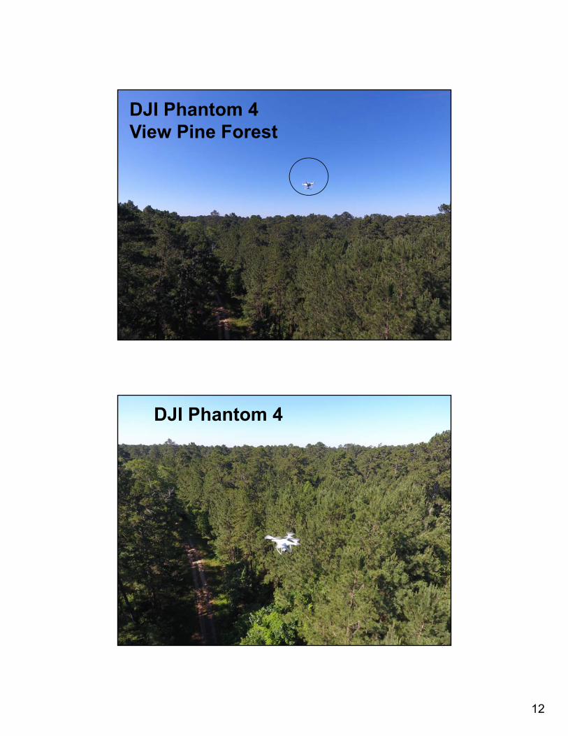
DJI Phantom 4View Pine Forest
Kulhavy, Unger, Hung, and Zhang, College of Forestry and Agriculture, Stephen F. Austin State University
DJI Phantom 4

13
Taking images and video for a visual assessment
Kulhavy, Unger, Hung, and Zhang, College of Forestry and Agriculture, Stephen F. Austin State University
Video
Monitor timber harvest operation, landscape ecology(patch, corridor, matrix, ecotone)
Kulhavy, Unger, Hung, and Zhang, College of Forestry and Agriculture, Stephen F. Austin State University

14
Kulhavy, Unger, Hung, and Zhang, College of Forestry and Agriculture, Stephen F. Austin State University
Visual identification of Ips beetle damage, drought, fire, pines, hardwoods, Forest Management Plans
Kulhavy, Unger, Hung, and Zhang, College of Forestry and Agriculture, Stephen F. Austin State University

15
Kulhavy, Unger, Hung, and Zhang, College of Forestry and Agriculture, Stephen F. Austin State University
UAS Mosaic
Kulhavy, Unger, Hung, and Zhang, College of Forestry and Agriculture, Stephen F. Austin State University
Implications and Questions

16
Measure building height with drone point cloud and Pictometry Spatial Science capstone course
Kulhavy, Unger, Hung, and Zhang, College of Forestry and Agriculture, Stephen F. Austin State University
On-screen height measurement on 30 buildings
Different methods compared
• Pictometry 4 inch resolution
• Drone point cloud as LAS in LP 360
• Drone point cloud in ArcScene
• Ground truthing with height pole
Compare accuracy of building height measurement between different methods
On Screen Building Height, Drone Point Cloud, ArcScene
Kulhavy, Unger, Hung, and Zhang, College of Forestry and Agriculture, Stephen F. Austin State University

17
Mosaic and georeference drone (UAS) aerial images
Kulhavy, Unger, Hung, and Zhang, College of Forestry and Agriculture, Stephen F. Austin State University
Flight line for mosaic
SFA Children’s Garden
Used for mosaic, building height, accuracy study of UAS, and surveying with total station
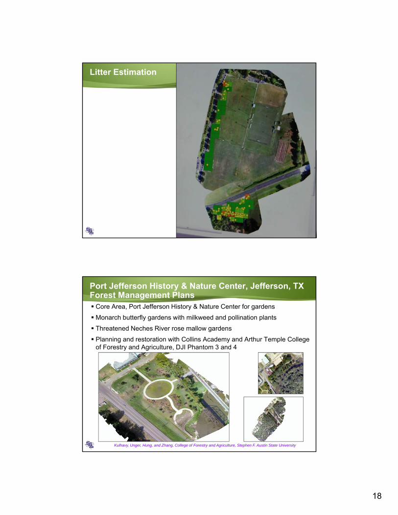
Hazard Rating for Litter Using the DJI Phantom 3Landscape Ecology—Environmental Science
50 square foot grid block
for litter estimation
Red block, high litter
Orange block, moderate litter
Yellow block, light litter
DJI Phantom 3
390 feet in height, 2.19 in resolution
Can assist in planning litter pick up
Flight time 20 minutes
Kulhavy, Unger, Hung, and Zhang, College of Forestry and Agriculture, Stephen F. Austin State University
18
Litter Estimation
Port Jefferson History & Nature Center, Jefferson, TXForest Management Plans Core Area, Port Jefferson History & Nature Center for gardens
Monarch butterfly gardens with milkweed and pollination plants
Threatened Neches River rose mallow gardens
Planning and restoration with Collins Academy and Arthur Temple College of Forestry and Agriculture, DJI Phantom 3 and 4
Kulhavy, Unger, Hung, and Zhang, College of Forestry and Agriculture, Stephen F. Austin State University

19
Measure height with DJI Phantom 3Spatial Science Capstone Course
Heights measured at 2, 5, 10 and 15 meters above ground on a height pole
Drone settings
• Continuous w/ GPS
• Continuous w/o GPS
• Reset w/ GPS
• Reset w/o GPS
Assess accuracy of height measurement by drone
Kulhavy, Unger, Hung, and Zhang, College of Forestry and Agriculture, Stephen F. Austin State University
How do we measure height?
Eye ball
Yardstick (hypsometer)
Height pole
Clinometer
Relaskop
Laser rangefinder
Kulhavy, Hung, Unger, and Zhang, College of Forestry and Agriculture, Stephen F. Austin State University
•Image source: Forestry Suppliers

20
A loblolly pine stands at 114 feet tall. Dying…
Kulhavy, Hung, Unger, and Zhang, College of Forestry and Agriculture, Stephen F. Austin State University
Kulhavy, Unger, Hung, and Zhang, College of Forestry and Agriculture, Stephen F. Austin State University

21
The drone used for this project - DJI Phantom 3 Standard
Aircraft– Weight: 1,216 g– Diagonal size: 350 mm– Max speed: 16 m/s– Max tilt angel: 35º– Max service ceiling 6,000 m MSL– Max flight time: 25 min– GPS and barometer– Hover accuracy: vertical 0.5 m, horizontal
1.5 m
Camera– Sensor: 12 M pixels– Lens: FOV 94º, f/2.8– Still photo: up to 4,000x3,000– Video: up to 1,280x720
Kulhavy, Hung, Unger, and Zhang, College of Forestry and Agriculture, Stephen F. Austin State University
•Image source: DJI
Gimbal– Stabilization: 3-axis (pitch, roll, yaw)– Controllable range: Pitch: -90° to +30°
Remote controller– Max transmission distance: FCC 1,000
m, CE 500 m– Mobile device holder: tablets and smart
phones with built-in WiFi
How does a drone measure height, and how accurate is that?
Sonar: calculate time a sound signal travels
Radar: measure frequency shift dependent on distance traveled by radar wave
GPS: trilateration of satellite signals referenced to geoid
Barometer: measure atmospheric pressure referenced to the ground
Kulhavy, Hung, Unger, and Zhang, College of Forestry and Agriculture, Stephen F. Austin State University
•Image source: http://dronepic.co.in/blog/how-to-measure-the-altitude-of-multicopter-quadcopter-uav-drone.html and http://www.mouser.com/new/maestrowireless/maestro-wireless-a5100/

22
Now we have UAS, unmanned aerial system
“An unmanned aircraft system ( UAS ), sometimes called a drone, is an aircraft without a human pilot onboard – instead, the UAS is controlled from an operator on the ground.” –FAA
An aerial vehicle, a ground-based controller, and a system of communications
Kulhavy, Hung, Unger, and Zhang, College of Forestry and Agriculture, Stephen F. Austin State University
•Image source: Wikipedia
Timber!!!
Kulhavy, Hung, Unger, and Zhang, College of Forestry and Agriculture, Stephen F. Austin State University

23
Drone measured heights by different flight settings
Kulhavy, Hung, Unger, and Zhang, College of Forestry and Agriculture, Stephen F. Austin State University
0.00
5.00
10.00
15.00
20.00
0 1 2 3 4 5
Average of measured height
(m)
Measured at different height points
Continuous‐GPS Continuous‐NonGPS
Reset‐GPS Reset‐NonGPS
2m 5m 10m 15m
Average measured height (m)n=30 2-m 5-m 10-m 15-m
Continuous-GPS 4.05 6.98 11.88 16.81Continuous-NonGPS 3.73 6.71 11.61 16.50
Reset-GPS 2.26 5.20 10.28 15.39Reset-NonGPS 1.91 4.88 9.99 14.96
Precision of height measurement by different flight settings
Kulhavy, Hung, Unger, and Zhang, College of Forestry and Agriculture, Stephen F. Austin State University
2‐meter 5‐meter 10‐meter 15‐meter
Continuous‐GPS 1.42 1.40 1.40 1.36
Continuous‐NonGPS 1.20 1.21 1.19 1.17
Reset‐GPS 0.22 0.28 0.30 0.40
Reset‐NonGPS 0.14 0.21 0.25 0.24
0.00
0.20
0.40
0.60
0.80
1.00
1.20
1.40
1.60
SD of measured height (m
)n=3
0
Measured at different height points

24
Drone measured heights by flight different settings
Kulhavy, Unger, Hung, and Zhang, College of Forestry and Agriculture, Stephen F. Austin State University
0.00
5.00
10.00
15.00
20.00
0 1 2 3 4 5
Ave
rag
e o
f m
easu
red
hei
gh
t (m
)
Measured at different height points
Continuous-GPS Continuous-NonGPS
Reset-GPS Reset-NonGPS
Errors of drone measured heights by different flight settings
Kulhavy, Unger, Hung, and Zhang, College of Forestry and Agriculture, Stephen F. Austin State University
2-meter 5-meter 10-meter 15-meterContinuous-GPS 2.48 2.41 2.33 2.25Continuous-NonGPS 2.09 2.08 1.99 1.89Reset-GPS 0.34 0.34 0.41 0.55Reset-NonGPS 0.17 0.24 0.25 0.24
0.00
0.50
1.00
1.50
2.00
2.50
3.00
RM
SE
of
mea
sure
d h
eig
ht
(m)
Measured at different height points

25
Landing drone before each height measurement is more accurate, while GPS does not play a role
Kulhavy, Unger, Hung, and Zhang, College of Forestry and Agriculture, Stephen F. Austin State University
Mean absolute
error of
measurement (m)
2‐meter 5‐meter 10‐meter 15‐meter
Continuous‐GPS 2.05 1.99 1.90 1.82
Continuous‐NonGPS 1.73 1.71 1.62 1.52
Reset‐GPS 0.26 0.24 0.31 0.45
Reset‐NonGPS 0.15 0.18 0.21 0.19
All 2-way ANOVA analyses found significant on landing setting, but not GPS; while there is no interaction between the two factors
Faculty Led Service Learning to Quantify Height
Kulhavy, Unger, Hung, and Zhang, College of Forestry and Agriculture, Stephen F. Austin State University

26
Kulhavy, Unger, Hung, and Zhang, College of Forestry and Agriculture, Stephen F. Austin State University
Kulhavy, Unger, Hung, and Zhang, College of Forestry and Agriculture, Stephen F. Austin State University

27
Kulhavy, Unger, Hung, and Zhang, College of Forestry and Agriculture, Stephen F. Austin State University
Kulhavy, Unger, Hung, and Zhang, College of Forestry and Agriculture, Stephen F. Austin State University
“Using spatial science technology senior undergraduate students under the direction of spatial science faculty learned how to accurately measure the height of vertical features in a landscape that could be used for observation and decision making purposes. This project allowed students not only to collect real-world data using different methods, but also learn how to analyze the collected data and interpret the outcome properly.”

28
Kulhavy, Unger, Hung, and Zhang, College of Forestry and Agriculture, Stephen F. Austin State University
“The results from the study and the students’ ability to acquire multifaceted spatial science information validate the hands-on instruction methodology employed in the spatial science curriculums within ATCOFA at SFASU. The results also reinforce ATCOFA’s mission by empowering students with the capability of employing sophisticated remote sensing technology to accurately quantify, qualify, map, and monitor natural resources.”
Kulhavy, Unger, Hung, and Zhang, College of Forestry and Agriculture, Stephen F. Austin State University
“Students learned that by integrating research into a hands-on senior level undergraduate spatial science course that knowledge and cognitive retention increases along with improved insights into spatial science applications within a natural resource context.”

29
Kulhavy, Unger, Hung, and Zhang, College of Forestry and Agriculture, Stephen F. Austin State University
“The integrated of the DJI Phantom 3 drone into the education process enhanced the ATCOFA message of work outdoors, make a difference and use high-end technology as active learners. The direction provided by the MUGS program reinforced higher order thinking skills and student achievement by integrating on-screen Pictometry measurements with in situ drone measurements compared to traditional height measurement techniques.”
Assess positional accuracy of drone derived aerial images
Kulhavy, Unger, Hung, and Zhang, College of Forestry and Agriculture, Stephen F. Austin State University
35 ground control points surveyed with total station for each geographic coordinates
Corresponding geographic coordinates attained on-screen based on drone orthomosaics
Assess positional accuracy of drone orthomosaics

30
Kulhavy, Unger, Hung, and Zhang, College of Forestry and Agriculture, Stephen F. Austin State University
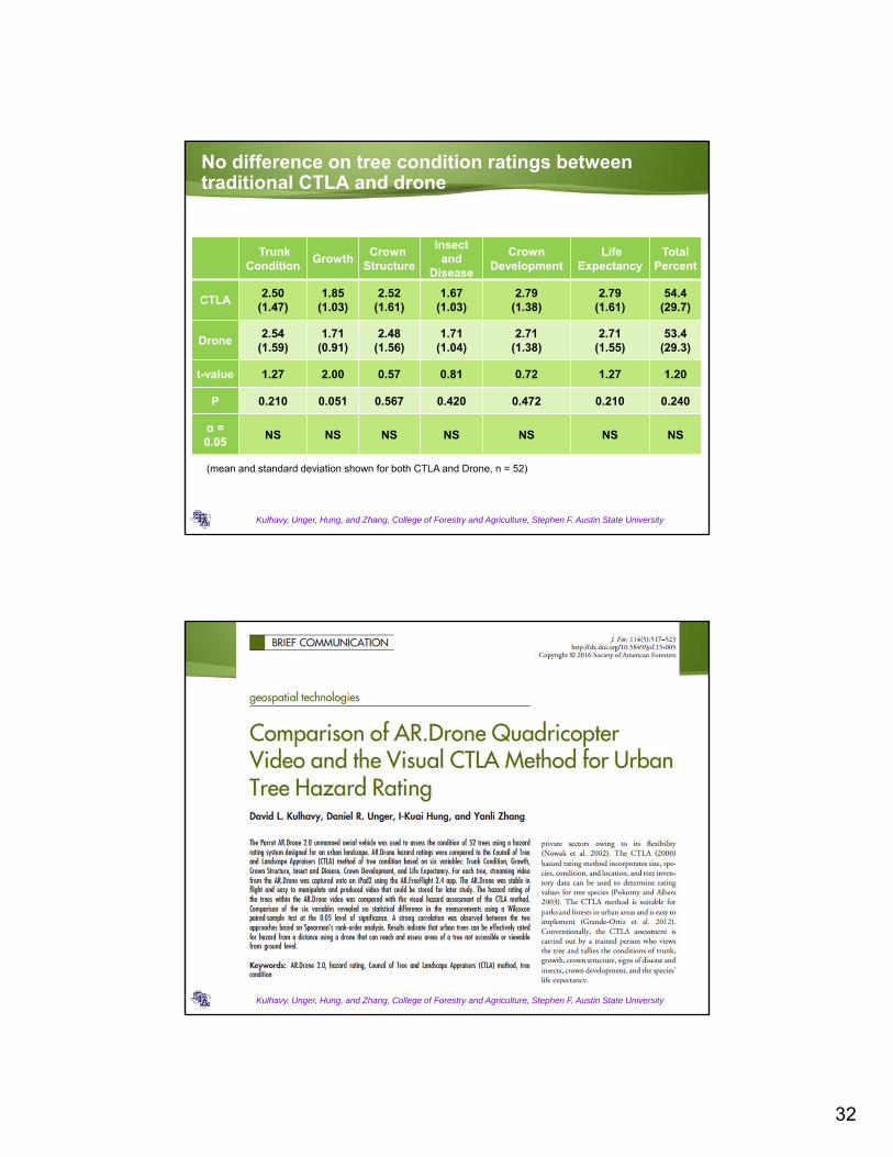
Rate tree condition with AR.Drone2.0
52 urban trees measured on campus and city parks, AR.Drone2.0
• DBH: 10-40 in.
• HT: 40-100 ft.
• Geographic coordinates recorded
Traditional CTLA (Council of Trees and Landscape Appraisers) rating conducted on site
Drone flown and video recorded
CTLA rating based on recorded video
Compare rating results between traditional CTLA and drone video
Kulhavy, Unger, Hung, and Zhang, College of Forestry and Agriculture, Stephen F. Austin State University

31
High correlation on overall tree condition ratings between traditional CTLA and drone
Kulhavy, Unger, Hung, and Zhang, College of Forestry and Agriculture, Stephen F. Austin State University
American Elm Box Elder Green Ash Live Oak Loblolly Pine Magnolia Maple Pear Pecan Red Oak Shortleaf Pine Sugarberry Sweetgum Water Oak Winged Elm
0
20
40
60
80
100
120
0 20 40 60 80 100 120
CT
LA
ove
rall
rati
ng
Drone overall rating
R2 = 0.96
A total of 52 trees measured
A tree with the possible highest overall rating
Kulhavy, Unger, Hung, and Zhang, College of Forestry and Agriculture, Stephen F. Austin State University
Total Condition = 26 (100%)
32
No difference on tree condition ratings between traditional CTLA and drone
Kulhavy, Unger, Hung, and Zhang, College of Forestry and Agriculture, Stephen F. Austin State University
TrunkCondition
GrowthCrown
Structure
Insectand
Disease
CrownDevelopment
LifeExpectancy
Total Percent
CTLA2.50
(1.47)1.85
(1.03)2.52
(1.61)1.67
(1.03)2.79
(1.38)2.79
(1.61)54.4
(29.7)
Drone2.54
(1.59)1.71
(0.91)2.48
(1.56)1.71
(1.04)2.71
(1.38)2.71
(1.55)53.4
(29.3)
t-value 1.27 2.00 0.57 0.81 0.72 1.27 1.20
P 0.210 0.051 0.567 0.420 0.472 0.210 0.240
α = 0.05
NS NS NS NS NS NS NS
(mean and standard deviation shown for both CTLA and Drone, n = 52)
Kulhavy, Unger, Hung, and Zhang, College of Forestry and Agriculture, Stephen F. Austin State University
33
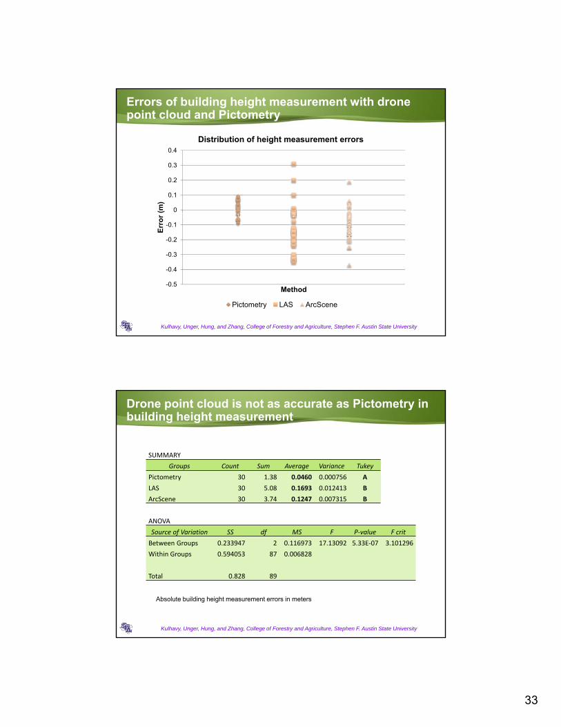
Errors of building height measurement with drone point cloud and Pictometry
Kulhavy, Unger, Hung, and Zhang, College of Forestry and Agriculture, Stephen F. Austin State University
-0.5
-0.4
-0.3
-0.2
-0.1
0
0.1
0.2
0.3
0.4
0 1 2 3 4
Err
or
(m)
Method
Distribution of height measurement errors
Pictometry LAS ArcScene
Drone point cloud is not as accurate as Pictometry in building height measurement
Kulhavy, Unger, Hung, and Zhang, College of Forestry and Agriculture, Stephen F. Austin State University
SUMMARY
Groups Count Sum Average Variance Tukey
Pictometry 30 1.38 0.0460 0.000756 A
LAS 30 5.08 0.1693 0.012413 B
ArcScene 30 3.74 0.1247 0.007315 B
ANOVA
Source of Variation SS df MS F P‐value F crit
Between Groups 0.233947 2 0.116973 17.13092 5.33E‐07 3.101296
Within Groups 0.594053 87 0.006828
Total 0.828 89
Absolute building height measurement errors in meters

34
Kulhavy, Unger, Hung, and Zhang, College of Forestry and Agriculture, Stephen F. Austin State University
Dylan Coleman, GIS 420, GIS 410, Spatial Science
Kulhavy, Unger, Hung, and Zhang, College of Forestry and Agriculture, Stephen F. Austin State University
Dylan Coleman, GIS 420, GIS 410, Spatial ScienceNovember 27, 2017

35
Kulhavy, Unger, Hung, and Zhang, College of Forestry and Agriculture, Stephen F. Austin State University
Comparison of LaNana Creek 1939 to November 2017Dylan Coleman, GIS 420, GIS 410, Spatial Science
FAA UAS Pilot Exam
Kulhavy, Unger, Hung, and Zhang, College of Forestry and Agriculture, Stephen F. Austin State University
60 question exam; 70 percent correct to pass
Background check by FAA and Homeland Security Good for two years
Six students passed the exam after 18 hours of training and up to 5 practice tests plus UAS flyingTake exam at FAA approved test site (e.g. LeTourneau University, Cleveland Airport, Just Fly! Flight Training)
36
Training Assistance/Study Guide
Kulhavy, Unger, Hung, and Zhang, College of Forestry and Agriculture, Stephen F. Austin State University
https://www.faa.gov/regulations_policies/handbooks_manuals/aviation/media/remote_pilot_study_guide.pdf
Training Assistance/Study Guide
Guidebook used for student training
Reviewed topics for 18 hours of meetings
with up to 5 practice tests
Scheduled FAA exam at approved site
Flew UAS (DJI Phantom 3 and DJI Phantom
4) for test flights with review of safety
procedures, flight plan using snapshots,
video and programmed flights (Pix4D),
Drone2Map and ArcGIS 10.5.2
Kulhavy, Unger, Hung, and Zhang, College of Forestry and Agriculture, Stephen F. Austin State University
37
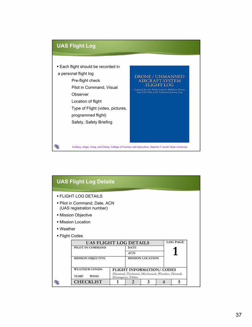
UAS Flight Log
Kulhavy, Unger, Hung, and Zhang, College of Forestry and Agriculture, Stephen F. Austin State University
Each flight should be recorded in
a personal flight log
Pre-flight check
Pilot in Command, Visual
Observer
Location of flight
Type of Flight (video, pictures,
programmed flight)
Safety, Safety Briefing
UAS Flight Log Details
FLIGHT LOG DETAILS
Pilot in Command, Date, ACN (UAS registration number)
Mission Objective
Mission Location
Weather
Flight Codes
Kulhavy, Unger, Hung, and Zhang, College of Forestry and Agriculture, Stephen F. Austin State University

38
UAS Flight Log Details
Kulhavy, Unger, Hung, and Zhang, College of Forestry and Agriculture, Stephen F. Austin State University
Completed before each flightCompleted after flight
(remove battery, turn offcontroller, make sure batteries are turned off, secure UAS, complete log book)
Mike Walker Property flown June 9, 2017
DJI Phantom 4, Programmed Flight, 80 Percent Endlap, 60 Percent Sidelap, Double Flightline
10 acres, 4 minutes, 120 meters (390 feet)
Pilot in Command, Visual Observer
Line of Site
Favorable Weather Conditions
Status of UAS Checked Prior to Flight (Battery Status, Visual Check of UAS, Propellers Properly Installed, Synchronized with Controller and UAS, Clean Take Off and Landing Area)
Synchronized Imagery (15 minutes)
Download Individual Images, Video, Programmed Flight (30 minutes)
Available to Landowner with Orthomosaic
Kulhavy, Unger, Hung, and Zhang, College of Forestry and Agriculture, Stephen F. Austin State University

39
Missions , Mike Walker Property, flown June 8, 2017
Kulhavy, Unger, Hung, and Zhang, College of Forestry and Agriculture, Stephen F. Austin State University
Mike Walker Property flown June 8, 2017Download to Drone2Map software into ArcGIS 10.4
Kulhavy, Unger, Hung, and Zhang, College of Forestry and Agriculture, Stephen F. Austin State University

40
Three Products: Orthomosaic, Hillshade, Elevation Model
Kulhavy, Unger, Hung, and Zhang, College of Forestry and Agriculture, Stephen F. Austin State University
Create New Project, Drone2Map
Kulhavy, Unger, Hung, and Zhang, College of Forestry and Agriculture, Stephen F. Austin State University

41
Mike Walker Property, flown June 9, 2017, Double Flight Line (Blue Dots, Photo, Programmed Flight
Kulhavy, Unger, Hung, and Zhang, College of Forestry and Agriculture, Stephen F. Austin State University
Kulhavy, Unger, Hung, and Zhang, College of Forestry and Agriculture, Stephen F. Austin State University

42
Kulhavy, Unger, Hung, and Zhang, College of Forestry and Agriculture, Stephen F. Austin State University

43
Kulhavy, Unger, Hung, and Zhang, College of Forestry and Agriculture, Stephen F. Austin State University

44
Kulhavy, Unger, Hung, and Zhang, College of Forestry and Agriculture, Stephen F. Austin State University
Kulhavy, Unger, Hung, and Zhang, College of Forestry and Agriculture, Stephen F. Austin State University

45
Kulhavy, Unger, Hung, and Zhang, College of Forestry and Agriculture, Stephen F. Austin State University
David Kulhavy, Daniel Unger, I-Kuai Hung and Yanli Zhang
Arthur Temple College of Forestry and Agriculture
Stephen F. Austin State University
Questions?The Use of UAS in Teaching Research and Service at Stephen F. Austin State
University

46
Acknowledgement
The Spatial Science team at the College of Forestry and Agriculture at Stephen F. Austin State University
McIntire-Stennis funds
Kulhavy, Hung, Unger, and Zhang, College of Forestry and Agriculture, Stephen F. Austin State University
Regional and National Scale Analysis
Arthur Temple College of Forestry and Agriculture, Stephen F. Austin State University
Kamiak Butte, WA
Unita-Wasatch-Cache National Forest, UT
Temple Fork, UT
Scenic Beach State Park, WA

47
Local Scale Analysis
Arthur Temple College of Forestry and Agriculture, Stephen F. Austin State University
Lanana Creek Trail, TX
ATCOFA FFA Demonstration, TX
Ips Beetle Tree Removal, TX
Lanana Creek, TX
Kulhavy, Unger, Hung, and Zhang, College of Forestry and Agriculture, Stephen F. Austin State University
Boy Scout Eagle Project, Labyrinth

48
Kulhavy, Unger, Hung, and Zhang, College of Forestry and Agriculture, Stephen F. Austin State University