the shipwreck of the - sidco.orgsidco.org/files/thurlow.pdfthe shipwreck of the ... the project...
TRANSCRIPT
The Shipwreck of the Olive Thurlow
By Robert K. Smith
Edited by Mark Wilde-Ramsing
Survey and Recovery done by the Surface Interval Diving Company
"Nonprofit Marine Archaeology and Exploration"
Artwork by Brian Parish
Robbie Girard
1

In Loving Dedication to...
My Lord and Savior, Christ Jesus, the Son of the Living God, and... My wife Linda Alleen and my wonderful little baby girl, Katie Allison... both
of whom were the gifts from a loving Savior.
"Thank you Lord, for giving me the desires of my heart..."
2

Introduction "How doh I git to...uh, Cape...Lookout?" This big, burly fellow with a dark complexion asked, from the window of a brand new Cadillac Seville, sporting New York license tags and a car top carrier filled with luggage. I looked down at his car... thought for a moment...and replied, "Buddy, you just can't get there from yere!" In all truth, I was right, for Cape Lookout is an island. Part of the North Carolina Outer Banks, it is located south of the famous Cape Hatteras, but is none the less important, historically. A pristine strip of land covered by patches of marsh grass, sea oats and the odd hammock of pine trees, it resembles a deserted island you might read about in "Robinson Crusoe". But this "hook" shaped oasis in a watery desert is a big part of "The Graveyard of the Atlantic". Here some 4000 shipwrecks lie awaiting discovery, and a chance to "tell" their stories. Cape Lookout Bight, formed by the "hook" shape of the land, has traditionally made a natural safe anchorage for passing ships in peril. During the early 1900's, the cape was a hub of shipping, ships came and went. The Cape Lookout Lifesaving station was located here, with all attempts to secure the lives and cargoes of endangered vessels. Even so many of the ships ended up on the bottom, in some hidden grave. Here, in the shadow of the Cape Lookout lighthouse lies one of those wrecks, which had a chance to tell her story. At 8 o'clock, on the night of December 3rd, 1902, the barkentine Olive Thurlow dropped anchor in Cape Lookout Bight about 1 1/2 nautical miles from the Cape Lookout Life-saving Station. The Olive Thurlow was 149 feet long, 32.7 feet wide and weighed 577 tons. She had been built in 1876 by the O.B. Rideout Company and was owned by the Pendleton Bros. Co. The ship had been fighting a storm off Bodie Island N.C. and had run with the lashing winds to seek shelter in the Bight. During the storm Captain J.O. Hayes had accidentally jammed his ankle into the steering quadrant and broken it just below the knee. With the captain having been taken to Beaufort for medical attention, First Mate C. Florian, at the advice of the Life-saving Station Crew, had readied the Thurlow for more bad weather as best he could. This time the wind came out of the WSW and was as bad as Keeper Gaskill (Life-saving station) had ever seen. On December 5th, 1902, the seas dragged the barkentine over toward the beach and dashed her on a shoal. One man, John Chaulkly, the Steward, was killed when the mast and rigging fell on him. The rest of the crew floated in on the cabin roof, flopping onto the beach "more dead than alive." The crew was cared for at the Life-saving station and eventually went to Beaufort. On May 12, 1995, after hearing of a "wreck" discovered 700 yards WSW of the Cape Lookout Lighthouse, we applied for and were granted a permit with the N.C. Department of Cultural Resources, for "Exploration and Recovery" of site 0004CLS located at 34 37'.32N 76 31'.92W. The project goals were to survey, investigate, map and chart the site and to recover any endangered artifacts. The hope was to suggest the site for a Protected Shipwreck Preserve.
3

This way divers could dive the wreck, non-divers could see the artifacts and everyone would benefit. With the help of Richard Lawrence and the NC Underwater Archaeological Unit, this task was begun and continued into 1996. Through the summer of 1995 the team worked against logistics problems, bad visibility, rogue "Bull sharks", boat troubles, minor equipment problems and as summer wore away; cold water. As 1996 came to be, we built on what we had accomplished and founded the Surface Interval Diving Company, a nonprofit corporation consisting of a consolidated team of divers and surface personnel dedicated to the proper archaeological survey, recovery, documentation, publication and display of historic shipwrecks and submerged sites for the express purpose of public display, education and enjoyment. We have all learned much from this project, artifact curation, mapping, historic research, but mostly...patience. Please enjoy this report which is the outcome of the Olive Thurlow Project. Look for much more to come from Surface Interval Diving Company. Oh, and by the way, please don't try to drive to Cape Lookout. Robert K. Smith President, SIDCO
4

Chapter One
History and Ship Description
Barkentine underway. The barkentine Klikitat seen above is very similar to the Olive
Thurlow. There are no known photos or paintings of the Thurlow. Photo courtesy Victor C. West Collection, Coos Art Museum
5

The Bark Olive Thurlow, was completed in September of 1876, in Calais, Maine. She was built by the O. B. Rideout Company, and at first was owned by Mr. James E. Brett, (the master at that time was captain T.T. Corbett) later to be owned by the Pendleton Bros. Co. The vessel was 149 feet in length, 32.7 feet wide, and 17.6 feet in depth, and weighed 577 tons (660 gross). The ship had a single deck and beams arrangement and was equipped with a small boiler to drive a steam powered hoist and windlass. The vessel was constructed of hardwood (beech, birch or elm) and hackmatack. Her official registry number was # 19468. Her official signal letters were JSCM. The Thurlow's hull was shaped in standard bark or barkentine form, consisting of a bilge or bottom with sealing or false bottom, and a single upper deck. Her bow had no figurehead, but was equipped with two "catheads", used to support the two large main anchors she carried, as well as the one (maybe two) "kedge" anchors, that were stored below. Aft of these catheads was a huge steam driven winch or windlass. This windlass was used to raise the massive, 11 foot long main anchors, as well as move large objects around the deck and to load cargo on and off the vessel. This windlass was either mounted on the foredeck (probably the case on the Thurlow) or mounted below the foredeck with only a "capstan" or spool extending above the decking. The windlass on the Thurlow had two spools, one on either end of the shaft (horizontally), and two inner spools containing the anchor chain. The steam drive motor mounted aft and below the shaft and was supplied steam from below deck. Aft of the "foredeck" was the forward cabin or "forecastle". This cabin contained several key items of ship's equipment. The cabin was illuminated by a single "skylight" in the roof and entrance was by a sliding door in the aft bulkhead. Inside the forecastle one would find the donkey boiler, coal bunker, some kind of cooking stove, and access to the anchor chain locker. Cooking was done here in order to contain fire, the most dangerous hazard on any ship, to one central area or cabin. Continuing aft would be the cargo hold. The forward part of the hold would have contained the two "kedging" anchors and possibly some spare sails and lines. Access to the hold was via two large hatch covers one forward of amidships and one aft. Movement below decks must have been a bit hard, because the huge "keelson" or inner keel stood some 4 feet tall above the bilge ceiling or floor, and ran through the center of the ship, bow to stern . Also, every few feet or so, a large iron "stanchion" or support pillar stood between the keelson and the bottom of the upper deck. Moving aft and back on the deck level, one would come to the "stern castle" or cabin. This is where the crew lived. Their berths were here as well as what little personal belongings they were able to have while on board the vessel. Room was extremely limited. A large skylight illuminated this space and it was this very important fixture that saved many of the Thurlow's crew in those last moments before she went to pieces. The crew held on to the cabin roof by sticking their arms through the skylight and let the roof carry them to
6

shore. Aft of the cabin was the "helm" or ships wheel. Also located in this area, the ships bell would have been in reach of whoever was on watch. The ship’s "binnacle" or compass and cover would keep the helmsman on course. This was possibly mounted on the bulkhead of the cabin, for ease of view. Somewhere on the deck, the pumps would be located, probably near amidships, beside the mainmast. These would be distinguished by the large spoked handwheels, which drove the pumps.
The stern was squared-off and possibly held the ships skiff or lifeboat by two davits. Just below this was the rudder, mounted on the end of the keel and lying
flush with the bottom edge of it. Early in the Thurlow’s 26 year career, in her home port of New York, she was converted to a Barkentine rig by her second owners. It has been suggested that this was done to save money, for the Barkentine rig is cheaper to set up and takes less of a crew to man.1 She was later assigned to Captain J. O. Hayes,(circa 1890),2 and during that time the barkentine put in for repairs several times, the last being in December of 1901. In February of 1896 her deck was caulked, and one year later she was brought in for "small repairs". In July of 1899, her bottom planking was caulked and in January of 1901 she was brought in for more small repairs and her forward and aft deck houses or cabins were caulked. That December she was drydocked a final time.3 Just a year later she would see her sad demise on Cape Lookout Bight. On December 5, 1902 the Olive Thurlow wrecked and became a total loss. She was bound for New York with a load of Pine lumber out of Charleston S.C., carried a crew of seven, and was commanded by Captain Hayes. The following account, taken from the U.S. Lifesaving service's annual report for that year ( 1902 ), explains what happened... "...When as far on her way as Bodie Island she ran into a gale from the north, veering to the eastward, and at about 4 o'clock in the morning of December 1, the master, deeming it no longer advisable to breast the storm, attempted to put his vessel before the wind. In order that no mistake should be made at the helm he himself took the wheel, and while he was trying to adjust the tiller ropes one of his feet was caught between the tiller and the quadrant and jammed with such violence as to break his leg just above the ankle. The vessel was got around without further mishap and headed to the southward, which course she maintained until 8 o'clock on the night of December 3, when she dropped her anchor in 7 1/2 fathoms of water about 2 1/2 miles northeasterly from the Cape Lookout Life-Saving Station. The weather was then thick and rainy with a moderate gale from the southward. On the morning for the 4th the captain, who had now been suffering intensely for three days with a broken leg, naturally desired to get ashore where he could receive surgical attention, and he therefore ordered a distress signal to be set in the rigging. "Two minutes later," as he says in his testimony, he saw the answering pennant of the life-
1 Letter from Nathan R. Lipfert, Library Director, Maine Maritime Museum, Bath, Maine. Letter dated 17 August 1993 2 1902 Record of American and Foreign Shipping, American Bureau of Shipping, Established 1867, a standard American classification of vessels. Obtained from Nathan R. Lipfert, Library Director, Maine Maritime Museum. 3 Ibid
7

savers station, "and twenty minutes later the life-savers were aboard." He was taken ashore, whence he was sent to Beaufort without delay, and in closing his affidavit regarding the disaster he states that he "received all possible attention and was under many obligations to the keeper and crew." Before leaving he vessel, Keeper Gaskill informed Captain Hayes that a very severe gale was imminent from the southwest, that the vessel was in a perilous position, and therefore he wished to be allowed to take her to a good anchorage in comparatively smooth water. This request the captain refused on the ground the she would not "head in and could not be put in stays"-- that is, that the movement suggested could not be made. The keeper, however, had not the slightest doubt of its feasibility, and furthermore, it appears that the tug Atlantic went alongside the Thurlow and proposed to tow her to safe water and convey the master to Beaufort, but the proposition was declined because Captain Hayes would not agree to the terms offered. When the keeper left the vessel she was riding to only 25 or 30 fathoms of chain, and although this was subsequently increased to 60 fathoms of chain on one anchor, the second mate in his testimony asserts the wreck to have been due to the fact that more scope was not given. The life-saving station kept a strict watch on the Thurlow from the time she anchored until her fate was sealed. As soon as the crew were convinced that she was certain to strand they fired two Coston signals, which Surfman Yeomans, on the north patrol, answered instantly. The life-savers got out their beach apparatus cart quickly, and since they knew that the beach was in a very bad condition for traveling, they divided the heavy load by placing a part of it in the driving cart. Then they set out with both vehicles on their toilsome journey of 2 1/2 miles through the soft, wet sand, with the wind blowing at the rate of 70 or 80 miles an hour, and, notwithstanding all the difficulties, reached the necessary position opposite the wreck within an hour from the burning of the distress signal on board. The doomed vessel was then lying broadside to the beach about 450 yards distant, and the sea was making a clean breach over her. All the men had taken to the lee mizzen rigging, and the business of Keeper Gaskill was to cast a shot line as nearly as possible into their hands. The wreck was gradually working to the westward, and therefore the sand anchor had to be moved some 50 yards from the position first selected. Then the Lyle gun was fired with a 6-ounce charge of powder and a No. 7 line. The projectile fell 15 or 20 feet short, however, and a second shot was no more successful, but the third, with a No.9 line and a 6-ounce charge landed fairly in the midst of the sailors in the mizzen shrouds. At that very instant the mast went down, the mizzen breaking off about 20 feet above the deck, crushing the skull of the steward, John Chalkly, and seriously injuring two other men. Chalkly's body fell overboard, while the others landed on the top of the house -- men, mast, topmast, and rigging tangled together. The vessel began to break up within half an hour after she struck, and disintegrated rapidly. First the foretopmast fell, then the forward house and deck load went overboard, then the bow and stern were torn off, the general ruin being finally completed by the falling of all the masts with a crash audible far along shore. The top of the after-house, or cabin, was the only place of refuge, and lying there the five sailors struggled for their lives, with only a precarious handhold on the skylight coamings. Meantime the life-savers quickly fired another line which fell almost into the hands of the shipwrecked men, who quickly as they could pulled off the whip and made fast the tail block to the stump of the mizzenmast, but, while the surfmen were engaged in sending out the hawser, a heavy sea tore off the top of the cabin on which the sailors were gathered and carried them with it into the breakers. The passage or these unfortunate men to the beach was a frightful spectacle, even to the surf-shore people, to whom shipwreck in its most harrowing form is no novelty. Lying flat upon the top of the cabin they thrust their arms through the windows of the skylight and desperately hung on. Two were sorely injured, and the other three assisted them as best they could. 'At times,' says the keeper, 'all must have been 10 feet under the water, when their grasp would almost fail, and even when they rose to the surface the break of the waves would nearly smother them again. At last one lost his hold and seemed sure to drown, but the life-savers went far out into the surf in spite of the wreckage and deadly undertow and saved him-- luckily themselves escaping great injury or death, which was liable to follow a
8

single blow from the heavy timbers thrust to and fro with terrific force. 'The rescued man', says the keeper, 'was more dead than alive when taken from the water.' The other four still held on, and as soon as they were near enough the surfmen again went out into the breakers and dragged the poor fellows to the beach. The second mate, who was badly hurt by the falling mizzenmast, and a sailor who had several flesh wounds and severe bruises, could not stand, and had to be carried to the station in a wagon. The three others were not wounded. None of the five could have held out much longer, nor any have saved themselves had they lost their places on the piece of wreckage which sustained them. All were at once taken to the station, where they were stripped of their wet clothing, wrapped in blankets, furnished with proper stimulants, and placed in bed. After two days they were sent to Beaufort. It must be regretted that Keeper Gaskill was not allowed to shift the Thurlow to a better anchorage, since it appears in the testimony that the schooner "Warren Adams" safely rode out the gale in a berth selected by him. The thanks of the Service are due to the keeper and two assistants of the Cape Lookout Light-house, and to several fishermen, for their voluntary and efficient aid in rescuing the shipwrecked men."4 The remaining crewmembers of the doomed ship penned this letter dated December 7, 1902... "We, the crew of the barkentine Olive Thurlow, which went ashore December 5, 1902 at 4 a.m., and became a total wreck in Lookout Bay, wish to thank Captain Gaskill and his crew, of Cape Lookout life-saving station, for the timely assistance and care received at their hands. We would also state that if the vessel had held together a little longer all would have been saved in the breeches buoy, but the mizzenmast broke, killing the steward and injuring two others, after their line had been made fast to it, for which they are in no wise to blame. C. Florian, Mate A. Curtin, Second Mate F. Finch, Seaman J. Johnson, Seaman G. Burgensen, Seaman"5
4 Michal T. O'Brian/ Noble, "Soldiers of the Surf and Storm" Pp. 110. 5 Ibid 9

Chapter Two
The Site Today...
10

The Klikitat ashore on Honlii Point, Hawaii. The circumstances of the Thurlow disaster are remarkably similar. Note the inverted flag at the top of the mast; a sign of distress.
Photo courtesy Victor C. West Collection, Coos Art Museum.
11

Today the wreck of the "Olive Thurlow" lies in 20 feet of water, with her port side extending to within 5 feet of the surface. Her coordinates are N 34 37’.298, W 076 31’.897 or 700 yards WSW of the Cape Lookout Lighthouse. This location is .83 Nautical miles from the Cape Lookout Life-saving Station (now referred to as the Coast Guard station). It should be noted at this point that after careful examination, the 2 1/2 mile position (from the L.S.Station) given in the wreck accounts was actually the approximate position of the ship's original anchorage and the Thurlow drifted diagonally with the position of the station, as she dragged her anchor during the disaster. This gives the site only a little more than a mile's distance from the station at the time of the sinking. The wreck lies on the edge of the channel leading through "Barden's Inlet", which is the only navigable passage through Cape Lookout Bight into Core Sound. The sand in this area of bottom is constantly shifting and is always covering and uncovering pieces of this and other wrecks in the area. It is theorized that the sand that covered and preserved the Thurlow, until recently, came from the opening of Barden's Inlet, which was washed open during the famous hurricane of 1933. Diving Concerns There are several important topics which need to be addressed before planing a dive on this site. Navigation: The site is marked by two buoys. A red nun has been placed by the U.S. Coast Guard between the wreck and the channel. This buoy is labeled "WR 4" or wreck 4, identifying the State site designation as "0004CLS". (Each wreck site in North Carolina waters is designated by a seven digit code to help keep up with the vast number of sites. The custodian of this system is the NC Underwater Archaeology Unit, Fort Fisher, NC.) The second buoy on the site is a white nun bearing an orange diamond and denoting "wreck" as to warn vessels to the danger from an underwater obstruction. This buoy was placed by Surface Interval Diving Company and will be indefinitely tended by the company. Currents: Currents on this site are devastating. At the height of the tidal cycle the current can be as fast as 5 knots or more. This is due to the close proximity of the inlet and is amplified by the movement of the sound water "draining" into the ocean at this point. A Northeast wind will double this effect. The wreck must be dived at slack tide. No other time is safe. Visibility: This site is subject to much movement of sand and sediment. This can destroy good visibility. There is no distinct pattern to the water clarity, but during the project visibility ranged from 1 foot to an incredible 35 feet. An incoming tide can clean the water up some. Also a good rule of thumb is to look for light winds the week before you dive. Dive Flags: Because of the close proximity of the channel, "Dive Flags" are a must! These flags alert other boats that divers are in the water. It is important to note that because the "Bight" is a difficult course to navigate there will be boat captains who may accidentally stray inside of the dive flag perimeter, and
12

also the ones who don't know what a dive flag is... It is best to have a topside observer to warn unwary captains to stay clear. It is illegal to violate the dive flag perimeter which is a 50 feet radius around the dive boat. Wildlife: Cape Lookout Bight is full of beautiful and benign wildlife, however, an occurrence did happen that is worth a cautionary note. On August 21, 1995, one of my divers was attacked by two small (4 or 5 foot) sharks, thought to be Bull sharks. The diver was not injured, but his tank had some scrapes on it. August is a "mating" time for the Atlantic Blacktip Shark (Carcharhinus Limbatus) inside Lookout Bight, and usually a few Bull sharks (Carcharhinus Leucas) follow the blacktips in. The blacktips are scared of their own shadow, but the Bull... is not! It is a good idea to be aware of this and know that the month of August is a time that Bull sharks may be in the area.
13
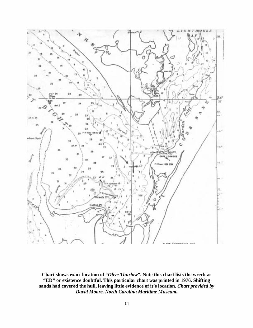
Chart shows exact location of “Olive Thurlow”. Note this chart lists the wreck as “ED” or existence doubtful. This particular chart was printed in 1976. Shifting
sands had covered the hull, leaving little evidence of it’s location. Chart provided by David Moore, North Carolina Maritime Museum.
14

Work Practices Because the Thurlow site had already been found and tentatively identified, we did not have to conduct a search phase during our project. We merely followed the layout of our State permit and went to work. Measurement practices: The measurements on the Thurlow site were done by using reference points and comparing points of interest to those reference points. A "base line" or "cross-wreck line" was installed on the main hull, extending from the very end of the cut-water and bow sprit (designated 00 feet) to the stern-most structure (designated 150 feet , actual measurement was 149 feet). Then this line was incremented every 5 feet ( 00, 05, 10, 15...) giving a numeric "scale" running the length of the hull. This gives us a "y" axis. Any item could be measured by identifying distance from item to base line ( using a tape measure and being sure to keep it perpendicular to the base line...), recording this as the "x" axis and then recording the increments on the base line, giving you the "y" axis. All measurements from the “base line” method, are designated x’(port or starboard), y’ (BL), or 12’S, 110’BL. Special note: Items found beyond the length of the main hull, either fore or aft of the base line, were measured independently or by extending the base line. Measurement: Our first order of business was to set up a reference point. As stated earlier, we chose a "base line" reference datum. This was because the initial site was elongated or oval in basic shape. This also made for a shorter distance to swim to measure artifacts and structures on the bottom. We later used "center-point" datums on other sites when those sites were circular in shape or smaller in size. Our next order of business was exploration of the site. We spent many dives just trying to identify all the separate parts and pieces of this wreck. The storm's destructive power and the wear of time have devastated this site. Divers would take a particular part and take notes on what they found when they got to their search area. We concentrated on the debris fields on the port side and near the bow of the main hull. Soon we located the "2nd" site and the boiler. Electronics: During this process we introduced the electronics. Using a Fisher M-scope CZ-20 discriminating underwater metal detector, we did many systematic searches of the different sites for brass and bronze artifacts. A few very nice pieces were found but nothing that positively identified the wreck as the Thurlow (The wreck was eventually identified using circumstantial evidence). Later while working with the NC Underwater Archaeology Unit and using their proton magnetometer (a device used to detect iron and other ferrous metals on the ocean floor), we were able to search the perimeters of the site and finally found the "bow" site, which contained the broken anchor and other circumstantial evidence. (See "Conclusions"). Several "test" excavations were done in and around the Port debris field. We used a gasoline driven jet/ trash pump and a home-built water induction
15

dredge (an airlift could not be used because the water was too shallow). The pump worked exceptionally well but we had problems with the dredge, which was at first too large in bore and later the exhaust angle was changed which seemed to fix the problems. These test excavations were conducted in a small area (80 feet to100 feet down main hull, on the Port side, 12 feet from the base line) and were once again used in an attempt to locate a single artifact such as the bell or a piece of china which would prove if it was the Thurlow or not. Mapping: Mapping this site took the entire time to finish, as bad visibility played a big role in this. The basic hull was done early but particular artifacts such as the stanchions and both seacocks had to be mapped in as they were found. Photographs and careful notes assisted in this process. Vegetation hindered this also as it would obscure the artifacts. The seaweed ranged from fuzzy "fire weed" in the early spring, "mermaid's hair" in the early summer, "eel kelp" or deadman's fingers in late summer and fireweed again in late fall. Navigation: Navigation on the site was difficult due to lack of visibility and much of the navigation work was done with good quality compasses. Later "down-lines" were established to allow a diver to follow a line to the different sites in the wreck perimeter. This allowed much easier and safer travel from say the bow site to the main hull. Topside navigation was done using white heavy-duty plastic jugs moored fore and aft to the main hull and bow sites using polypropylene rope. A central "wreck" buoy was installed but was "stolen" by Hurricane Fran. It will be replaced and "kept up". This was moored just beside the main hull by chain and cement anchor. An iron anchor will be used in the future. Wood samples: Wood samples were taken from several different sections of the site. These wood samples or wedges cut from the structure of the wreck, were analyzed by a laboratory to identify the type of wood or family from which the ship was built. Since we knew what woods were used in the construction of the Thurlow, this was added to the list of circumstantial evidence (for results and details, see Conclusions). Anchor recovery: The large "kedge" anchor was recovered on June 18, 1996 in a joint effort including Surface Interval Diving Company, the NC Underwater Archaeology Unit and the National Park Service. Divers from Surface Interval connected a large lifting "hauser" or thick rope, supplied by the NC UAU, to the anchor and a crane and "landing craft" type vessel from the National Park Service lifted the anchor from the bottom and transported the artifact back to NPS headquarters at Harkers Island, NC where the anchor was transferred to a trailer and taken to Fort Fisher, NC for proper rust and corrosion treatment. This included very high heat treatment (1000 Degrees for four hours) and sand-blasting and painting. The anchor was then transported back to Harkers Island where it was placed on display, in front of the Cape Lookout National Seashore Headquarters.
16

Clean-up:
As a final service to this site, we cleaned the wreck of all our left-over equipment; anchors and chain for buoys, old down-lines, sunken buoys, trash from other parties, and even lead sinkers which always litter this site, left by sport fishermen. It is our intention to leave this site as historically pristine as is humanly possible. Our hope is that the history is preserved on this site, for all to enjoy, and that other divers will strive to leave it the same way, in order that even more divers may also enjoy it after them. The Site The Thurlow site is spread out into five major parts. These are: Main hull, Boiler, Bow, "shroud" site, and the 2nd site. The Thurlow was in an excellent state of preservation when our project started in May of 1995. For example, there was wood ceiling on the main hull that was stronger and prettier than most people's dining room tables. Some degradation has taken place due to uncovering of the sand and sediment from the wreck. This has taken place naturally. As the channel tends to be moving toward the wreck, the wreck is excavating itself. Eventually the wreck will end up at the bottom of the channel and due to lack of the sand's protective covering, "shipworms" will eat the organic material, leaving nothing but the concreted iron. This process could take as long as 15 or 20 years and by then the wreck could be covered again. These conclusions are theoretical, of course. Main Hull: The main hull is the focal point of the site and reveals some interesting structure to examine. The hull is lying on the Eastern "bank" of the channel, with the bow pointing towards 250 degrees, magnetic, and on a 65 degree list to starboard. The port timbers are pointing towards the surface and make a formidable danger to an unwary deep-draft vessel. They are at 4 to 5 feet below the surface while the starboard side timbers are at 18 to 19 feet below the surface. The hull is intact from the keel to the "turn of the bilges" or the "chines", and from the "cutwater" of the bow, along the length, to within 15 feet of the stern. Nearly everything that would have been in the bilges of the ship are still there, with the exception of cargo and ballast. The remains of the hull measure a maximum of 149 feet x 31 feet. The measurements are the same as the dimensions given in the Ship’s Record for 1902.The Record gives the dimensions for all major ships built during that period (for the most part). Even though the bow and transom broke away from the hull during the wreck, we believe these are good measurements because the Record’s measurements were taken below these structures, and were not included in the length and width. We simply, were measuring from the same points as the builder, which are located below the waterline. The 31 feet beam is more or less in some areas because of lack of timber in some places. The structure above the "turn of the bilges" is missing, and we believe the wreck may have been burned as a "derelict", which was a common practice in times
17
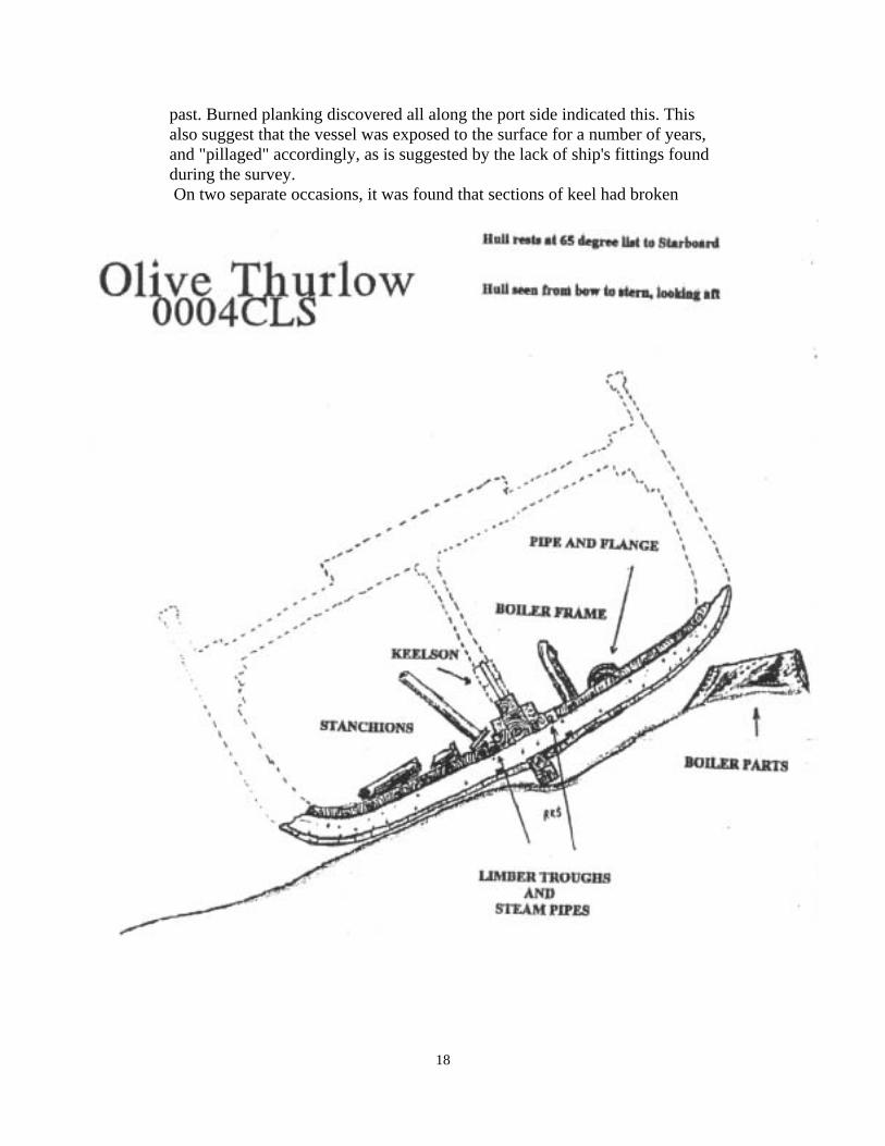
past. Burned planking discovered all along the port side indicated this. This also suggest that the vessel was exposed to the surface for a number of years, and "pillaged" accordingly, as is suggested by the lack of ship's fittings found during the survey. On two separate occasions, it was found that sections of keel had broken
18

away and fallen to the bottom. Fortunately we had made the proper measurements before the structures broke away. The first section was 10 feet in length and broke away from the stern section of keel. This was observed during a survey dive on 7-15-95. The condition that caused this was an undermining by strong tidal currents at the stern of the vessel. The predominately heavy outgoing tide actually washed the sand and debris from underneath the wreck, exposing the keel for approximately 40 feet! In places at the stern, a diver could swim completely under the hull! Later on 8-5-95 it was noted that 5 more feet of stern had broken away and fallen to the sand. The keel, however survived both Hurricane Bertha and Fran in 1996. By examining the main hull, which is shaped very much like a long and very wide canoe, a diver will find the lower ships structure, complete with many of the same timbers and fittings that it sailed with. Her bilge "ceiling" is somewhat complete from just abaft of the bow to somewhat abaft of midships. These boards measure 10 inches across and run parallel to the keel and keelson. They are somewhat haggard in places, with holes that allow one to see the outer planking and frame timbers. The frame timbers measure 12 inches wide and vary from 12 to 16 in depth. Keelson: The keelson on the Thurlow was extremely tall, measuring 44 inches in height and 27 inches in width and was built by stacking timbers on top one another and fitting them together with long iron pins. This allowed the stanchions to be shorter and more stout. The stanchions were mounted on top of the keelson and to the bottom of the upper deck to form a strong support structure. About half of the keelson is missing having been eaten by "shipworms", however the iron keelson pins or drift bolts remain, thus allowing an exact measurement of the original keelson height. Bilge features: There are several distinguishable artifacts still attached by concreation or other means to the bilge area of the main hull. These are shown on the site map and discussed as they were found from the bow moving aft. Anchor: The anchor was recovered on June 18, 1996, by Surface Interval Diving Company, the NC Underwater Archaeology Unit, and the National Park Service. During the dive season of 1995, the anchor was hanging on the hull structure 6 1/2 feet high off of the bottom and was an impressive sight. During the last weeks of Fall '95, the anchor became dislodged and fell to the bottom landing with it's flukes parallel to the sand. The anchor then became an easy target for unauthorized looting. After discussing the matter with Richard Lawrence of the NC UAU and Bill Harris of the National Park Service, it was agreed that it would be recovered and after conservation, would be displayed near the lighthouse at Cape Lookout, along with site maps, photos, survivor's accounts, and information. The prospective display will overlook the Thurlow site.
19

This is a "kedge" anchor, which was a smaller anchor used for special
20

A second set of drawings of the Kedge anchor recovered from the Thurlow site. The anchor is now on display at the National Park Service Headquarters on Harkers
Island, North Carolina.
21

purposes such as pulling the ship off of a shoal or when a large anchor would be less convenient than the smaller kedge. The anchor weighed 1660 lbs including concreation and marine growth and measured 8 feet in length (see illustration for measurements). The stock of this anchor was made of iron and is straight. The ball on one end appears to be removable and there is a wedge in the opening between the stock and the shaft of the anchor. This would have allowed removal of the stock for storage. The stock was in the unstowed or "ready for use" position at the time of the disaster, however there was no chain attached to the anchor, which may have played a role in the ship's demise. The anchor, when first recovered, was located at coordinates (4'S; 12' bl). It fell and landed at coordinates (11'S; 14' bl). After recovery the anchor was transported to the NC Underwater Archaeology Unit at Fort Fisher, NC where it was cleaned, documented, stabilized and preserved. Pipe: Just abaft of the bow structure at coordinates (2'P; 6' bl) is a large diameter pipe jointed to a smaller diameter pipe. The concreation and surrounding structure did not allow an exact measurement to be taken, but the large pipe was about 5 inches inside diameter and the smaller pipe was about 2 inches inside diameter. They are lying with the joint pointed aft and parallel to the keelson. The large pipe is about 4 feet in length and the small pipe is about 6 inches long. It is unknown exactly what function it had; however, because the pipe lies directly below the location of the windlass, it may have been the steam manifold supplying the windlass. Limber troughs and pipe: The limber troughs which run fore and aft next to the keelson and are formed by notches in the ceiling planks, are basically intact on the Thurlow hull. It is very interesting to note that the troughs have steam pipe running inside them. This is small pipe, about 1 1/4 inside diameter. What is puzzling is that limber troughs provide access to the waste ways in the bilge where trash and debris would collect and prevent flow to the bilge pumps. The steam pipes would hinder or block this access. It is theorized that the pipes may have supplied steam from the boiler to a "radiator" inside the main cabin for heat, a convenience added after the original construction of the ship. This makes sense, because there is no other apparent reason for their being there. The cabin could have been heated by a wood stove or some other fuel burning device, but this would have increased the danger of fire on board the ship. It would have been far better to have had only one fire burning on board (the boiler room). No heating device was found in the cabin area so this is only educated conjecture. Forward Seacock: Just across from the large pipe, is the forward seacock. This is a large valve leading from inside the bilge to outside the hull. It was used to drain the ship of residual water and dirt lying inside the lower bilge when she went into dry-dock. Seacocks were also used throughout history to "scuttle", or to intentionally sink a ship by opening them and allowing the ship
22

to fill with outside seawater. This one lies on the Starboard side at coordinates (2’S; 8’ bl), right next to the keelson. Although obscured by structure and concreation, it is discernible by the large (12 inch wide) control wheel attached to the valve. The wheel faces out from the keelson toward the Starboard side of the ship. Stanchions: As earlier mentioned, a "stanchion" is a support post, in the case of the Thurlow made of iron, located between the top of the keelson and the bottom of the upper deck beam. These offered the ship strength and durability throughout the whole structure especially while carrying a full deck load. There are three of them still on the Thurlow, all located near the Starboard bow. One is still standing on it's base, near the keelson, on the Starboard side at coordinates (3S; 11bl). This has often been mistaken for a mast by boaters and fishermen because of it's position. With a diameter of only 8 inches it is much too small to be a mast. The top of this stanchion is twisted off and pounded down to resemble much thicker metal than it really is, 1/2 inch. This is testament of the incredible destructive force that tore apart the Thurlow. The base of another stanchion, is located (5’S; 17’ bl). This one is lying on the hull pointing towards the starboard side. It is the same diameter as the others. The third stanchion at coordinates (6’S; 18’bl) was, at first, a case of mistaken identity. When it was first discovered, it too, had been beaten down on one end to resemble much thicker metal, and stuck out of a pile of debris, resembling a cannon and a large "conch" shell covered the side of it as if hiding a "trunion" (pivot of a cannon). This put doubt the possibility of the wreck being the Thurlow, because it was very unlikely that she would have carried a gun. After many dives and photographs, finally on 8-21-95, The conch shell was broken away using a make-shift slide hammer, and no trunion was present. It was then determined that it was a stanchion by feeling around in the opening at the top that had so resembled a gun barrel. This was "rolled metal" just like the others and what had looked like 2 inches thick had only been 1/2 thick. (See photos.) Boiler Frame: At (2’P; 38’ bl) feet, is an iron bulkhead, standing off of the bilge ceiling, near the keelson. This bulkhead is approximately 3 feet square and is mounted upright. This is suspected to be a support frame for the boiler. It's located in the right place and is around the right height to support a small boiler. It is bent toward the port side of the ship, indicating that a force drove the boiler from it's mount, toward the port side of the vessel where the boiler now rests. Shackle and Turnbuckle: These pieces of huge hardware are located near amidships on the port side of the hull, concreated to the bilge ceiling. They are possibly spare rigging parts, kept or stowed below deck. The shackle measured a massive 15 inches across and is located at (10’P; 65’ bl). The turnbuckle, located only a foot away, is also very large. It is approximately 1
23
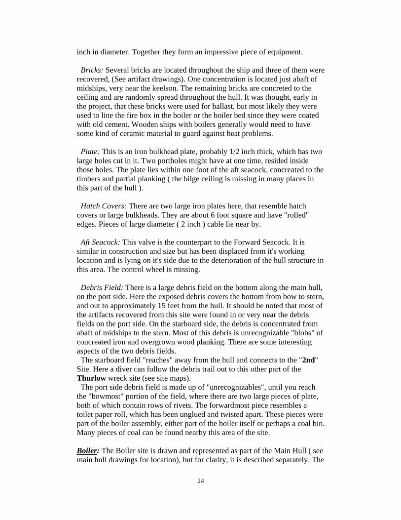
inch in diameter. Together they form an impressive piece of equipment. Bricks: Several bricks are located throughout the ship and three of them were recovered, (See artifact drawings). One concentration is located just abaft of midships, very near the keelson. The remaining bricks are concreted to the ceiling and are randomly spread throughout the hull. It was thought, early in the project, that these bricks were used for ballast, but most likely they were used to line the fire box in the boiler or the boiler bed since they were coated with old cement. Wooden ships with boilers generally would need to have some kind of ceramic material to guard against heat problems. Plate: This is an iron bulkhead plate, probably 1/2 inch thick, which has two large holes cut in it. Two portholes might have at one time, resided inside those holes. The plate lies within one foot of the aft seacock, concreated to the timbers and partial planking ( the bilge ceiling is missing in many places in this part of the hull ). Hatch Covers: There are two large iron plates here, that resemble hatch covers or large bulkheads. They are about 6 foot square and have "rolled" edges. Pieces of large diameter ( 2 inch ) cable lie near by. Aft Seacock: This valve is the counterpart to the Forward Seacock. It is similar in construction and size but has been displaced from it's working location and is lying on it's side due to the deterioration of the hull structure in this area. The control wheel is missing. Debris Field: There is a large debris field on the bottom along the main hull, on the port side. Here the exposed debris covers the bottom from bow to stern, and out to approximately 15 feet from the hull. It should be noted that most of the artifacts recovered from this site were found in or very near the debris fields on the port side. On the starboard side, the debris is concentrated from abaft of midships to the stern. Most of this debris is unrecognizable "blobs" of concreated iron and overgrown wood planking. There are some interesting aspects of the two debris fields. The starboard field "reaches" away from the hull and connects to the "2nd" Site. Here a diver can follow the debris trail out to this other part of the Thurlow wreck site (see site maps). The port side debris field is made up of "unrecognizables", until you reach the "bowmost" portion of the field, where there are two large pieces of plate, both of which contain rows of rivets. The forwardmost piece resembles a toilet paper roll, which has been unglued and twisted apart. These pieces were part of the boiler assembly, either part of the boiler itself or perhaps a coal bin. Many pieces of coal can be found nearby this area of the site. Boiler: The Boiler site is drawn and represented as part of the Main Hull ( see main hull drawings for location), but for clarity, it is described separately. The
24

boiler lies 49 feet away from the main hull, on the port side of the vessel, adjacent to the bow. As consistent with the heavy damage to the rest of the ship, "storm forces" must have "rolled" the boiler away from the hull. The Boiler of the Thurlow is relatively small, but still makes an impressive structure underwater. When it was first located by John Dorgan, then Assistant Director of Surface Interval Diving, it so impressed him that he described it as the "bow" of another wreck. At the time of discovery, it was at least half buried. Compared to the heavy boilers of a steamship though, it is much smaller and is often refered to as a “donkey boiler”. It was meant only to provide steam for the windlass on the bow and heat for the cabins. It did not provide any "drive" power to the ship. The boiler measures 11 feet in length, and 4 feet 6 inches in diameter. It is cylindrical with one end plate missing and severe damage to the surrounding metal of that end. It appears that a large "bite" has been taken out of one corner of the damaged end. The "bite" runs the width of the boiler and 3 feet of the length. (See drawing) It is unclear if this is the result of a boiler explosion due to cold water exposure. ( a hot "operational" boiler will explode if submerged or washed over by cold sea water.) The heavy damage in the area of the main hull that contained the boiler and the "spreading" of boiler parts is suggestive of a boiler explosion. There is nothing inside the boiler except sediment and the odd piece of metal. No piping was found near the boiler. There is a "port" or orifice in the undamaged end of the boiler. This port is oval in shape and measures 1 foot 3 inches tall and 9 inches across. It is unclear what this was for, except perhaps to supply working steam to the windlass. One red brick was found below the undamaged side of the boiler, suggesting that the bricks may have been associated with the boiler. Bronze piping was found on the opposite side of the main hull, (see artifact 028 and 029), from the boiler, and may also be associated with the boiler. One of the pipes bore the words "ATW BOSTON". Research from the Boston Public Library indicated that The American Tube Works was established in 1851 and their offices were still listed in Boston in various building addresses until 1935 when they moved to Somerville MA. By 1961 the company had disappeared. The American Tube Works claimed to be the "original manufacturer of seamless drawn brass tubes, copper tubes, and brass pipe, in America." In 1912, their ad claimed "Green's and Alston's Patent and Adams's Patent for locomotive, marine and stationary boilers and other uses...".6 It is possible that American Tube Works built the Thurlow’s boiler.
6 Letters from Roger L. Snow and Katherine Dibble, Research Library Office, Boston Public Library, dated 10/24/96.
25

Boiler from the Olive Thurlow. Note heavy damage to the one end. Drawing by Robbie Girard.
"2nd Site": The "2nd" site was named because it is still not certain that this is not another wreck lying beside the Thurlow. This site is located on the
26

starboard side of the main hull 75 feet out in the channel of Barden's Inlet. (see map on page 13) There are pieces of debris that resemble keels or parts of keels and heavy bulkheading that vaguely resemble hull timbers. There is also a possibility that this is the "transom" of the Thurlow that broke away in the initial stages of the disaster (see survival accounts in Chapter one; History and Description). Some of the debris on this site resemble inner hull timbers and bulkheading. The site lays perpendicular to the Thurlow’s keel. It can be found by swimming to the stern of the hull and following the debris field on the starboard side to the bulk of the second site debris. The site is very broken up with debris lies everywhere in no particular pattern or "trail". [Note: On this site we used a "center-point" datum, or marker instead of a "base" or "cross-wreck" line. The artifacts were measured by taking distance from center point and compass heading to artifact, instead of "x and y" coordinates.] Net: The first piece of discernible debris is a large "monofiliament" gill net, entangled in the conglomerated shipwreck debris. This gillnet runs for several
27

yards and is sanded up most of the time. It is not really a danger to wildlife because of the sanding effect. Box Frame: Also visible is a 2 feet square iron box frame. It is unclear what this artifact was but it does make an interesting landscape marker and the "center-point" datum was placed nearby (3 feet away from the box heading 130 degrees). West of the datum, there are four large pieces of bulkheading, the largest of which is 16 feet x 7 feet. These pieces of debris resemble "lattice-work" or layers of crossed timbers. There are also at least two large timbers (2 feet thick by 7 feet in length), lying about on this section of the site. This may be the "transom" from the Thurlow which broke away in the midst of the initial impact of "bumping" bottom as the ship came aground (see survival accounts in Chapter One). The Bow broke away at the same time, which allowed the then unsupported rigging to come crashing down. This debris may also be decking or upper works from the main hull portion of the wreck. Bow Site: This is the most interesting portion of the Thurlow site (with the exception of the Main Hull), and probably the least dived ( by non- SIDCo divers) of any part. The Bow site was located on 7-27-95, using a "magnetometer", a device used to detect changes in the earth's magnetic field. A shipwreck, containing iron fasteners or spikes, would make a change in the field on the ocean floor and this device will detect that and thus locate a shipwreck. It is located 146 feet from the southwest tip of the main hull on a heading of 273 degrees. It lies in about 21 feet of water. This is in close proximity to the channel leading to Barden's Inlet and extreme care should be used if this site is explored due to overhead boat traffic. This site came to be when, in the initial inpacting of the hull striking the nearby shoal, the "heavy" bow section (along with a section of the stern) broke away and fell to the bottom. Without the "tether" of the anchor chain and the one anchor set by first-mate Florian, the main hull then slid along the bottom, leaving the bow section off to itself. Bow Structure: The bow structure itself is made up of the upper portions of the bow deck, including the windlass, the upper bulwarks, hause pipes and other assorted bow related deck gear. It is lying in a tilted manner on the starboard bow bulkheads and has spun so as to aim the bow almost directly at the one set anchor and parallel to that anchor’s extended chain. Windlass Wheels: Upon approaching the bow section, the most prominent structures are the huge "flywheels" of the steam windlass. The aft wheels (one set on a common axle), measure 4 feet in diameter and have five spokes. They stand off of the bottom, just aft or behind the other set. This set is "offset" or displaced from the rest of the windlass. The second set, containing the clutches, chain cleats, and brakes lie in position as though ready to use. The wheels on this axle measure 4' 4", or slightly larger in diameter than the aft set, and have seven spokes each.
28

Bow site as drawn by Robbie Girard. Note windless and gears. Also note the extended anchor chain passing through the “hause pipe”.
Two huge "bearing caps" were found in the sand within three feet of the displaced wheels and possibly held the aft set in place. A box-shaped piece is present aft of the aft set of wheels and could be part of the steam motor used to drive the windlass. Framework: Making a circle toward the East (as the site is basically circular in shape), the next structure found is a large framework, four feet high. This may have been some kind of structural framework for the forecastle. It is possible that it could have been the frame, which supported the ship's bell. Broken Anchor: Just beyond this is the broken anchor. This is the remains of the Starboard anchor. It is 11 feet in length, with an 8-inch wide shank or body of the anchor. It has a hole for the stock or crossbar, that measues 10 inches inside and the anchor is missing its stock. The ring or eye at the top of the anchor is 12 inches in diameter and has no chain attached. Both flukes have been broken away, leaving only two feet of arm on one side and three feet on the other. Neither fluke was found on the site suggesting that the anchor was broken before the grounding of the ship. As mentioned earlier in the text, this anchor was considerably larger than the "kedge" anchor, recovered from the main hull (see "Main Hull" section). This broken anchor served as one of the main anchors. Anchor Chain and Hause Pipe: Along the Southern most side of the bow
29

site, a diver will come across the port side anchor chain lying on the sand, stretching out into the channel toward the WSW. This chain, being very large and heavy, has links 7 inches long and 1 1/8 in diameter. It covers and uncovers with the sand's movement around the site. A magnetometer survey along the track of this anchor chain, indicated a large iron object at the end of the chain, suggesting that this is infact the Port anchor that was set on December 4, 1902 with 360 feet of chain. The approximate distance between the bow site and the iron target is 350 to 360 feet. The chain, passes through a completely intact hause pipe, (a pipe built into the side of ships for the heavy chain to slide through, so as not to damage the hull or bulkheading) on the port side. Because of placement of windlass and remaining bow structure, this could only be the Port side of the vessel. The hause pipe is oval shaped and 2 feet tall by 1 foot across at the opening which is somewhat bell shaped. "Shroud site": 40 feet inshore of the bow site (heading of 140 degrees) is a concentration of miscellaneous debris that is thought to be the remains of the bow sprit rigging. There is a large chain lying about in a scattered condition, and two large turnbuckles or harnesses of some kind. These turnbuckles consist of two pieces of cable, mounted parallel by two small crossbars. They were attached to the ends of the chain. The chain is 1 inch in diameter and is smaller than the anchor chain found on the bow site. There are a few scattered timbers here and not much else. At the time of our last dives, this part of the site had almost sanded over and was not expected to remain exposed above the sand much longer.
30

Shroud site as drawn by artist Robbie Girard. Very little remained of this part of the site.
31

Main Hull Site Maps The following site maps were drawn by Brian Parish and Robert Smith. Measurements are in feet/ inches unless otherwise indicated. Butt ends of ceiling Planks are representative and are not exact. Concretion masses are representative as the structures below could not be "cleaned of their protective coverings without risking further degradation. All other details are as exact as possible.
32

Above: Wreck buoys (one red, marked "WR 4"on the left and two white in the foreground), mark the Thurlow site. In the distance, the Cape Lookout Lighthouse can be seen. The wreck lies in 20 feet of water, 700 yards WSW of the lighthouse. Photo by author. Below: A black sea bass swims slowly beneath the aft section of the keel. This section later collapsed and fell to the bottom. Wildlife on the Thurlow site is abundant and contains many tropicals including angelfish and butterflyfish. Photo by David Pope.
33

Above: A semi-permanent “wreck” warning buoy placed by Surface Interval Diving. The main hull is close enough to the surface to present a hazard to navigation. The boat in the distance is the NC Underwater Archaeology Unit’s vessel “Snap Dragon”. The vessel in the far distance is the National Park Service’s landing craft “Shell Point”. This photo was taken just before the anchor was recovered from the main hull. Photo by Todd Cook. Below: A section of boiler or boiler parts near the port bow of the main hull. Many pieces of coal can be found nearby. Photo by David Pope.
34

Above: The anchor being lifted by a National Park Service "landing craft" and crane. Also assisting in the recovery, were Surface Interval Diving Company divers and divers from the NC Underwater Archaeology Unit. Photo by Todd Cook. Below: The author stands beside the anchor for scale as it awaits preservation treatment at the NC Underwater Archaeology Unit, Fort Fisher, NC. Photo by Richard Lawrence.
35

Above: One of the iron stanchions used as support beams between the keelson and the
underside of the upper deck. Seen here from above, it closely resembles a small cannon. Photo by the author. Below: Another view, this time from in front of the stanchion. Note
the thickness of the metal. Actually the sides are only ½ inch thick, but the metal had been rolled down by the beating action of the upper deck as the ship broke apart. This
made it resemble the thick iron found on a cannon. Photo by the author.
36

Above: An american eel pokes his head out from under a piece of debris on the Thurlow site. Shipwrecks are condominiums for marine life of all kinds. Photo by author. Below: A juvenile queen angelfish swims along the main hull of the Thurlow. Just one example of the stark beauty the tropical fish provide to this wreck. Photo by author.
37

Above: A brass spike at moment of recovery. Here an artifact is photographed as it is found. All artifacts are measured and recorded prior to recovery. Note the orange tape measure in lower left corner. This is artifact # 0004CLS045. Photo by author. Below: The same artifact after the preservation process. All artifacts are preserved to current archaeological standards. Photo by Connie Mason.
38

Chapter Three
Artifacts, Conclusions and Suggestions
39

Artifacts As a special note, it should be pointed out that the artifacts recovered during this project were preserved in accordance with current archaeological standards and methods and that the artifacts are drawn to those same standards and are scaled in inches. Artifacts are listed in numerical order according to their assigned state tracking number or project number. A description for every artifact is included.
40

Artifact 0004CLS001 Date Recovered: 6-4-95 Location: (01’ P; 00’ bl.)
Notes: This artifact was found almost directly under bow structure, lying exposed on the sand, and partially buried in sediment. It is a small drinking glass, 3 3/8 inches tall and 2 ½ inches across at rim. The sides appear to be “frosted” from
tumbling in the sand. The number “05” appears on the bottom.
41

Artifact 0004CLS002 Date Recovered: 6-10-95 Location: (1’S; 112’ bl)
Notes: This red building brick was found near several others, some of which were concreted to the wreck structure by marine organisms. It is a non-standard size and
somewhat larger than brick of today. This concentration of brick is strewn from about 75 feet on the base line to about 120 feet and within a foot of the hull.
42

Artifact 0004CLS003 Date Recovered: 6-16-95 Location: (25’S; 35’ bl)
Notes: Brass or bronze building spike, broken and bent on top end. Head is missing. May have come from deck housings as the Record for 1902 states that the Thurlow’s
deck housing were fitted with “copper” or brass fasteners.
43

Artifact 0004CLS004
Date Recovered: 6-16-95 Location: (05’S; 12’ bl)
Notes: This is treenail, a wooden dowel used as a spike or nail in shipbuilding. This artifact is in great shape and was discovered near the bow section of the main hull.
44

Artifact 0004CLS005 Date Recovered: 6-16-95 Location: (08’P; 65’ bl)
Notes: This bottle is in excellent shape with only mild scaring and abrasion from exposure to the sand. Standing 7.5 inches tall it is blown glass with a cork stopper lip and a spiral assembly design. The bottle is crudely assymetrical in shape. The
inlaid label reads “James Redmond, Newberne, NC”. The inscription on the bottom reads “NO. 1”.
45

Artifact 0004CLS006 Date Recovered: 6-16-95 Location: (08’P; 70’ bl)
Notes: This sharp, pointed iron or steel object has a “stainless steel” sheen and may have been a tool such as a “marlin spike”, used to work rope and cables on board
ship.
(1) Front, (2) Left side (3) Back (4) Right side
46

Artifact 0004CLS007
Date Recovered: 6/ 24/ 95 Location: (18’P; 35’ bl)
Three pieces of coal located near remains of boiler support structure. (1) 0004CLS007A (2) 0004CLS007B (3) 0004CLS007C
47
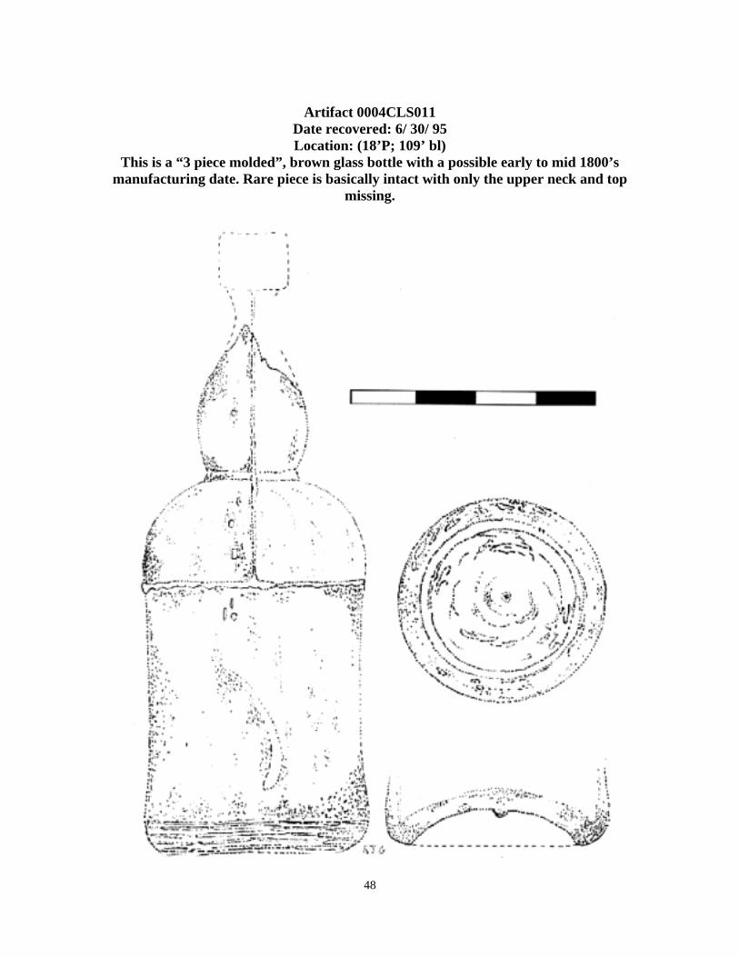
Artifact 0004CLS011
Date recovered: 6/ 30/ 95 Location: (18’P; 109’ bl)
This is a “3 piece molded”, brown glass bottle with a possible early to mid 1800’s manufacturing date. Rare piece is basically intact with only the upper neck and top
missing.
48

Artifact 0004CLS012 Date recovered: 6/ 30/ 95 Location: (12’S; 23’ bl)
This cork net float was found lying in debris on the starboard bow section of the main hull. It appears to be compressed flat by water pressure and may have been
snagged along with a fisherman’s net or may have been part of the cargo.
49

Artifact 0004CLS014 Date Recovered: 7-8-95 Location: (16’P; 131’ bl)
Notes: An iron building spike, possibly used in the lower hull area. Head is missing and appears broken by great stress. Measures 6 inches long and 5/8 inches thick.
(1) Front, (2) Left Side, (3) Back, (4) Right Side, (6) Squared shank end, (6) Tip
50

Artifact 0004CLS016 Date Recovered: 7/ 14/ 95 Location: (12’S; 30’ bl)
Appears to be a small brass hinge, perhaps associated with a box of some kind.
51

Artifact 0004CLS017 Date Recovered: 7-14-95 Location: (18’S; 30’ bl)
Notes: A “softball” sized piece of Quartz rock, about 4 inches square. Possibly left over from an earlier cargo or ballast load.
52

Artifact 0004CLS018 Date Recovered: 7-15-95
Location: (70’S; 110’ bl) Notes: This bottle may date to circa 1800’s due to two-piece molding. It stands 12 inches tall and is colored blue-green. It has the inscription “HOULDING’S BREWERY Co. Ltd, LIVERPOOL”
53

Artifact 0004CLS019
Date recovered: 7/ 16/ 95 Location: (30'S; 51' bl)
Bronze pipe fitting, union or a drain perhaps, threaded for 1 inch pipe. Probably associated with the ship’s boiler system.
54

Artifact 0004CLS021
Date recovered: 7/ 16/ 95 Location: (50'P; -39' bl)
Bottle recovered near the boiler on the Port side. It is 9 inches tall and deep green in color. The inscription reads: CLICQUOT CLUB, TRADE MARK, and at the bottom, REGISTERED. The picture on the bottom is a man in colonial dress
holding a large bottle.
55

Artifact 0004CLS022
Date recovered: 7/ 27/ 95 Location: (0 degrees X 12', bow site datum)
Iron ship-building spike from the bow section, very similar to artifact 014, recovered from the main hull. Matching artifacts will most likely tying the two sites
together.
56

Artifact 0004CLS023 Date recovered: 7/ 27/ 95
Location: (221 degrees X 3', bow site datum) This is a simple brass door hook, which was found still screwed into a timber, on the bow site. As an example of every-day hardware from the ship, it is one of the nicest
pieces recovered during this project.
57

Artifact 0004CLS024 Date recovered: 8/ 11/ 95 Location: (15'P; 27' bl)
Brown glass bottle, 6 inches tall at highest break. Inscription at bottom reads: PROPIEDAD DE LA COMPANIA RON BACARDI. S. A. Possible rum bottle
dating circa 1900.
58

Artifact 0004CLS025 Date recovered: 8/ 26/ 95 Location: (18'S; 02' bl)
This is what appears to be a “chainplate” or a device used to fasten the mast shrouds to the side of the ship’s hull.
59

Artifact 0004CLS026 Date recovered: 8/ 26/ 95 Location: (19'P; 100' bl)
This standard size building nail found in a very small piece of planking. This common nail may not have come from the wreck.
60

Artifact 0004CLS027 Date recovered: 9/ 4/ 95 Location: (18'P; 85' bl)
Small brass nail possibly used to attach metal sheathing to the hull.
61
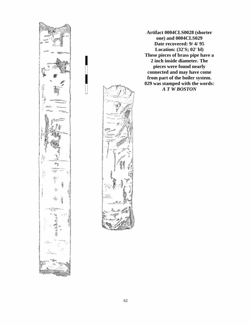
Artifact 0004CLS0028 (shorter one) and 0004CLS029
Date recovered: 9/ 4/ 95 Location: (32'S; 02' bl)
These pieces of brass pipe have a 2 inch inside diameter. The
pieces were found nearly connected and may have come from part of the boiler system.
029 was stamped with the words: A T W BOSTON
62

Artifact 0004CLS030 Date Recovered: 10-20-95
Location: (15'P; 00' bl) Notes: Brass building spike broken off leaving the top third. Head is complete.
63
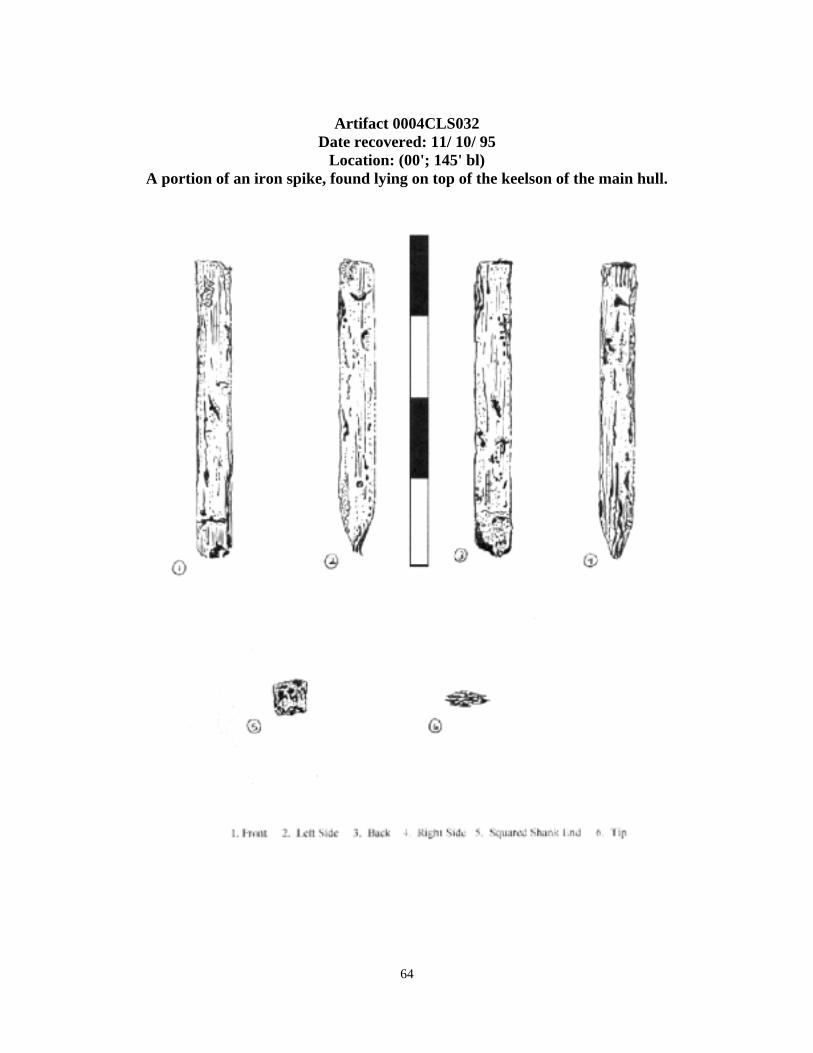
Artifact 0004CLS032
Date recovered: 11/ 10/ 95 Location: (00'; 145' bl)
A portion of an iron spike, found lying on top of the keelson of the main hull.
64

Artifact 0004CLS033 Date recovered: 11/ 17/ 95
Location: (19'S; 30' bl) This is a complete iron spike, approximately 12 inches long and ½ inch wide.
65

Artifact 0004CLS034 Date recovered: 5/ 3/ 96 Location: (9'P; 110' bl)
A piece of white china pottery. Both a lip and a base of the vessel are represented on the artifact. There are no markings or patterns.
66

Artifact 0004CLS035 Date recovered: 5/ 3/ 96 Location: (20'P; 100' bl)
This light-green glass bottle has an uneven seem, an hour-glass shaped neck, a “blob” top, and is tapered from midsection to bottom. Note markings on the bottom.
67
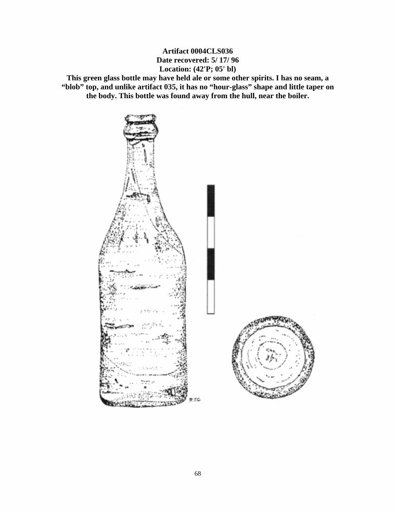
Artifact 0004CLS036 Date recovered: 5/ 17/ 96 Location: (42'P; 05' bl)
This green glass bottle may have held ale or some other spirits. I has no seam, a “blob” top, and unlike artifact 035, it has no “hour-glass” shape and little taper on
the body. This bottle was found away from the hull, near the boiler.
68

Artifact 0004CLS037 Date recovered: 5/ 17/ 96
Location: (5'S; 5' bl) A second brick, possibly from the boiler bedding (see artifact 002), with red color
and no cement attached. The brick is somewhat larger than modern brick of today.
69

Artifact 0004CLS038 Date recovered: 5/ 17/ 96 Location: (1'P; 150' bl)
A broken bottle of light green glass, measuring about 5 inches tall. Bears the words Botella Registrada.
70

Artifact 0004CLS041 Date recovered: 6/ 14/ 96 Location: (10'P; 12' bl)
This is a large brass (or “copper”) fastening pin, approximately ¾ inch thick stock. One end shows a “mushrooming” effect from the blows of a hammer. The pin is
probably broken.
71

Artifact 0004CLS042 Date recovered: 6/ 15/ 96 Location: (16'P; 100' bl)
Small piece of glazed china pottery, about 2 inches by 2 inches, no marks are visible and no lip or base are seen on this artifact.
72

Artifact 0004CLS044 Date recovered: 6/ 18/ 96 Location: (10'P; 60' bl)
Small glazed pottery representative of chinaware, 1 inch by 1 inch, no markings or features.
73
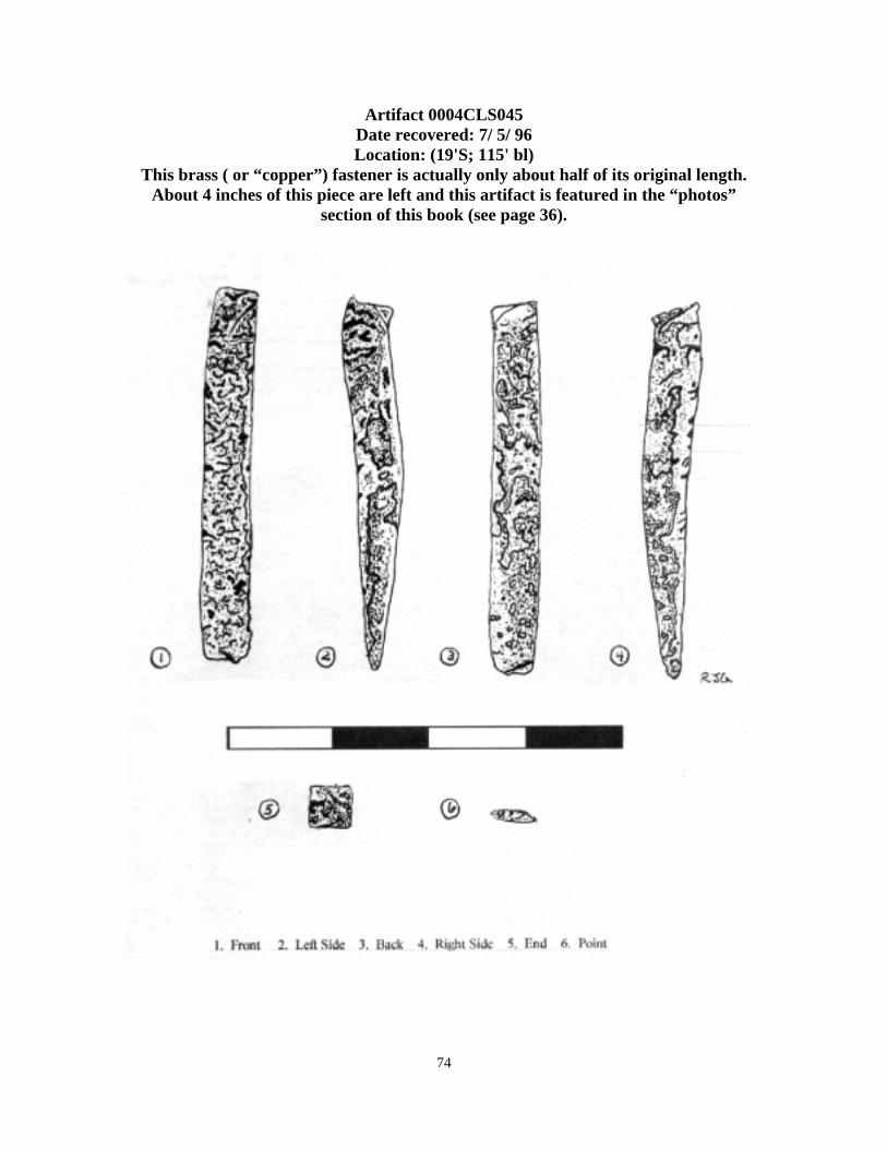
Artifact 0004CLS045 Date recovered: 7/ 5/ 96 Location: (19'S; 115' bl)
This brass ( or “copper”) fastener is actually only about half of its original length. About 4 inches of this piece are left and this artifact is featured in the “photos”
section of this book (see page 36).
74

Artifact 0004CLS046 Date recovered: 7/ 27/ 96 Location: (2'P; 150' bl)
The top is all that remains of this clear glass milk bottle. The top opening is 2 inches wide and the words NC APPROVED appear at the top. The words ONE P--- appear
near the break.
75

Artifact 0004CLS047 Date recovered: 8/ 10/ 96 Location: (11'P; 65' bl)
Very small pottery chip of chinaware, 1 inch by ½ inch, piece has no markings or features. Color and texture consistent with other pottery recovered from the site.
76

Artifact 0004CLS049 Date Recovered: 10-18-96
Location: (05'S; 10' bl) Notes: This brick, dark tan in color, is inscribed with the words: BALTIMOR_
W.P.B. CO. Brick measures 4 inches by 7 inches by 4 inches.
77

A second set of drawings of the Kedge anchor recovered from the main hull of the Thurlow site. The anchor (artifact number 0004CLS050) is now on display at the National Park Service Headquarters on Harkers
Island, North Carolina.
78

Conclusions Many of the particular details of the destruction of the Thurlow are not listed or described in the "Wreck Reports" or the survivor's accounts. A few questions remain but many were answered by the archaeological investigation. December 3, 1902 8:00 PM The Thurlow dropped her anchor in 7.5 fathoms of water, approximately 2.5 miles NE from the Cape Lookout Life-saving Station. The station being located at 34 36' 30"N 76 32' 20"W7. This immediately indicates that the ship dragged her anchor for a good distance before going ashore on the shoal. The weather being rainy, they waited until the morning of the 4th to signal the L.S.S. for assistance concerning Captain Hayes' broken leg. This could have been the captains demands, but it stands to reason that a good First Officer would have acted sooner. This may suggest as to why he did not do more to protect the ship later in the disaster. Perhaps Captain Hayes was a strict disciplinarian and held a tight reign over his crew. This destroys all but the very best first officer's ability to function on his own. Later that morning, the L.S.S. crew boarded the vessel and was later accompanied by the tug "Atlantic". Even after being warned about the danger of the anchorage and being offered both a free move by the L.S.S. crew and a tow for a fee, the captain would not move his vessel. Having had a broken leg may have impaired his judgment, but his First Officer, Florian, had no broken leg. The captain was taken to Beaufort for medical care and even after he had left, Florian, still would not move his vessel. Instead, he increased the length (or scope ) of chain on the one deployed anchor from 25 or 30 fathoms to 60 fathoms or 360 feet.8 Anchors The greatest probable cause of this disaster is the lack of proper anchors/ anchorage. This is not mentioned in the reports (probably to protect the career of First Mate Florian) except the lack of more "scope" not being given9. Until we found the "Bow site" of the wreck we did not realize just how negligent Florian had been (part of the circumstances were not his fault). We know that the Thurlow carried at least three anchors. We will label these (for this text) A, B, and C. "A" is the one anchor that was set, with 360 feet of chain or scope attached. Though we have never seen this anchor, we feel that it does exist. When examining the bow site (as mentioned in the site description), you will see a large (1 1/2 inches) anchor chain leading away from the site towards the WSW. Using a magnetometer, we detected a large anomaly or target, suggestive in size, to a large main anchor. We were unable to visually verify this anchor because it was buried right in the middle of the channel. This target lies very close to the aforementioned 360 feet away from the bow site.
7 Sonny Williamson, Unsung Heroes of the Surf, The Lifesaving Service of Carteret County, (Marshallberg, NC: Grandma Publications, 1992) Pp 9. 8 Michal T. O'Brian/ Noble, Soldiers of the Surf and Storm Pp. 102 9 Ibid 79

We have distance and bearing matching the scope of the anchor chain and the wind direction mentioned in the wreck reports and survivor's accounts on the morning of the mishap. We also know that it was the Port side anchor that was set. On the bow site (see site map) the hause pipe is present with the chain for this anchor leading through it. This hause pipe is still mounted on the port side of the bow, which can be determined by the shape of the remaining timbers. "B" anchor is the broken anchor found on the bow site, within six feet from the starboard side of the bow. This anchor is missing both of it's flukes, one side is also missing most of it's arm. It is also missing it's stock which we believe to have been wooden and was probably devoured by shipworms. It is possible that this damage occurred during the disaster, however, it should be noticed that there is no chain attached to this anchor's ring. This suggest that the anchor was already broken, (this explains why only one anchor was set when the vessel arrived in the Cape bight) possibly in Charleston harbor while the vessel was loading or just before getting underway, perhaps on some underwater obstruction. This also suggest that at the last minute the crew was attempting to replace the broken anchor with the smaller "kedge" anchor ("C"), which was either on deck and they just ran out of time or was below deck, under the deck load, which would have been unwise to attempt to get at. (To attempt this, they would have had to move the deck load, shifting the weight and unbalancing the ship...making a bad situation even worse). Why didn't the crew simply change the broken anchor on the voyage home or while still at Charleston? This remains a mystery. Perhaps they were planning on going straight home and not anchoring anywhere else. If the "kedge" was stored on deck, then this was a great oversight on captain Hayes' part. If the kedge was stowed below deck then this is very understandable. It should also be noted that the kedge's stock, which is "stowable", or moveable into a position that allows the anchor to be layed down, therefore take up less space, was in the "unstowed" position. This suggest that the kedge was on deck and accessible. "C"...the kedge. The Kedge is a smaller anchor than the two main anchors, though the designs were basically the same. The kedge measures 8 feet tall, while the main anchors measured 11 feet in length. Also the kedge has an iron stock, while the mains had wooden stocks. The kedge was a tool rather than a mooring device, used to pull the ship from off of a sand bar or other obstruction. It's small size made it more manageable, and easier to move about. Anchor "D"? On a pre-survey investigative dive, members of the NC Underwater Archaeology Unit made a "quick" sketch of the site and during this dive, observed what could have been a forth anchor on the forward-most Port side of the main hull. The anchor was never seen by our survey and it was thought that the anchor may have been stolen. No evidence of this anchor was ever found. The UAU sketch does not show the Starboard position of the kedge "C" anchor. There are three possibilities for this turn of events. (1) The sketch was drawn in error. This is extremely unlikely given the UAU's great
80

amount of experience and high standard of quality. Even low visibility would not have caused such a mistake. (2) There was a forth anchor and the looters made a clean getaway. With the heavy patrols of the National Park Service and other law enforcement entities nearby, this is hard to swallow. Several large anchors were investigated in the local area but with no real results. This remains a remote possibility. (3) The most interesting scenario is the possibility that "C" was located on the Port side during the sketch, then some action caused the anchor to "roll",(such as an attempted illegal removal) end over end, to the Starboard side and lodge there in such a way as to end up in the same position as it was lying in on the Port side. Crazy as it sounds, this would explain a great many things. A dark night...a quick attempt to steal the anchor...suddenly a vessel approaches from the distance, so the line is cut and the dislodged anchor falls back on the wreck, this time landing on the Starboard side...the "lift" line rots away... We probably will never know for sure. December 5th, 1902 4:00 AM With the knowledge that the Thurlow would not survive a storm that had brewed up from the South, especially in her chosen anchorage position, the Life-saving crew had kept a close eye on the ship during the night. When Florian burned the two blue "coston" flares, the station was alerted that the ship was sliding to her doom. As the seas beat against her and the water beneath her keel raised and lowered, she struck the shoal slightly WSW of her present position. Almost upon impact, her "very heavy" bow containing the windlass and many tons of anchor chain sheared off like a layer cake, and fell immediately to the bottom, substantiated by the length of anchor chain and position of "bow site" structure. Without the support of the bowsprit and bow structure, the masts and rigging were incredibly weakened. Also during this brief moment, the stern transom broke away and fell apart. (We believe this is the debris trail that makes up the "2nd site", see site maps). The vessel continues on toward the NE, bumping along the shoal as it sinks. It will stop approximately 150 feet to the NE, at it's present location.(See site description) December 5, 1902 4:30 AM Soon after the initial damage, the foretopmast falls. The vessel must be quivering with each wave now and soon after the deck load breaks loose and goes over the side.10 Very soon after, the forward house, containing the boiler room, goes over the side. Evidence of an elaborate "plumbing" system suggest that a radiator was located in the main cabin (located aft) to provide heat. Pipes laid in the limber troughs would have supplied steam to the radiator which would have been actively working that night. The damage to the boiler and parts suggest that the hot boiler, now exposed to the cold December waters, explodes and spreads debris across the bottom. The boiler itself, rolls across the bottom on the port side of the vessel and comes to rest there on the port side of the main hull slightly forward of it's mount as the hull slides past it for a couple of yards. December 5, 1902 5:00 AM
10 Ibid
81

The crew has taken to the mizzen rigging on the leeward side, (closest to the beach, as the wind was out of the WSW) and the mast are now dangerously unstable with only the shrouds to hold them up. After several shots from the Life-saving services lyle gun, the rigging gives way dumping the crew on the deck, injuring two badly and killing John Chalkley. In the midst of total chaos, it should be noted that all of the debris is going to Port and aft of the hull and building the debris field that we found on the site. Lumber, pieces of ship, rigging, torn sails, debris and the like are all collecting on the beach. The remaining crew of the doomed barkentine have nowhere to go but on the deck. They cling to life on the roof of the aft cabin with their arms stuck through the broken skylight. Suddenly that roof gives way and is washed toward the beach. What would seem to be their death is their salvation. The roof finally ends up in the breakers after being under as much as 10 feet of water at certain times as each wave broke over it. The poor men are dragged from the water like bags of flower. As for the dying ship... she becomes a bit of history. Artifacts Judging from the artifacts recovered during this project (see artifacts, this chapter...) the crew of the Thurlow must have enjoyed a great array of alcoholic beverages. Some of these were not just whiskey, but an early civil-war era bottle possibly contained something as exotic as perhaps aged brandy or some other collectable. Other bottles were "bottled" in such places as South America, England and Spain or Portugal. Nearly all of the glass artifacts ( save two) could be attributed to some form of alcohol. It would suggest that either the men went to great lengths for strong drink or that the Thurlow did a bit of traveling in her day. One bottle (non-alcoholic), suggest that the ship had visited Beaufort before. The bottle marked "James Redmond, New Berne, NC" (artifact 005) was most probably bottled in Newbern and might have held some medicine of some kind. Research is continuing on this artifact. Another interesting artifact was a large brick recovered near the bow of the main hull (see artifact 049). The brick is reddish-brown, 4x4x6 inches in size (one end was chipped off ), and labeled with the words "BALTIMOR- W.P.B. CO. BLOCK". An architectural historian told me that the "P.B." stands for "pressed brick".11 Another friend suggested that in all probability, W.P.B. CO. stands for the Westport Paving Brick Company, located in Westport, MD. This company was located in Baltimore City and was still in business in 1930. He suggest that this artifact is most likely a brick paving block.12 Wood Samples A series of wood samples was removed and analyzed, but the results were somewhat inconclusive. Four samples were taken; A- floor timber, B- outer planking, C- keelson, D- ceiling planking. These were examined by the Center for Archaeological Investigations, Southern Illinois University. Originally, these samples were indicative of "hackmatack" wood, which would indicate the building material of the Thurlow. Sample B (outer planking) was found to
11Letter from John Snyder, Architectural Historian, 1-28-97, e-mail media 12 Letter from Paul Schopp, dated 1-28-97.
82

be "tamarack or eastern larch"13 An article by Edward Ackerman identifies tamarack and "european larch" as hackmatack14 (european larch was also mentioned in the original analysis of sample B). This information alone would effectively identify the vessel as the Thurlow, however, a later report with a more detailed analysis, also from Southern Illinois University, suggested that the sample in question (sample B) was actually Douglas Fur. Sample A was thought to be live oak or black oak, sample C was thought to be hard or yellow pine, as was sample D. This does not seem to add up and would suggest that this wreck was not the Thurlow, however, because of the poor condition of some of the structure of the wreck, more wood samples will be taken at a later date in hopes of re-examining the building materials. There is still enough circumstantial evidence to suggest that this ship is in fact the Olive Thurlow. The bow site alone (see site description) will indicate that, not to mention position, dating of the artifacts, and positioning of artifact material.
13 Report from Lee Newsom, Center for Archaeological Investigations, Southern Illinois University at Carbondale. 14 Edward Ackerman, “Rediscovering Hackmatack”, The Woodenboat, March- April, 1976, Pp. 44-46 83

Recommendations: Site 0004CLS Originally, a survey of the Thurlow site was conducted to investigate the site, but also in preparation for a possible recomendation to the "List of Historic Places". However, because of the high rate of degradation and destruction of the site due to exposure to "ship" worms, storms, boat traffic and other damaging effects, it was suggested to use, enjoy, study and observe the site, but to leave it off the historic list. This does not "belittle" the historic value of the site, but does leave it open to use by all parties and the general public. We believe that the site should be strongly used by scientific entities such as the Cape Lookout Studies Program, sponsored by the NC Maritime Museum. The rich ecosystem living on and around this site is ideal for observation and study purposes. The Thurlow is also perfect for use by the Marine Archaeology Summer School, sponsored and taught by the Underwater Archaeology Unit, Fort Fisher, NC. We do suggest also that the site be properly marked with a standard "wreck" buoy, consisting of a white nun, displaying an orange diamond and the site designation. The red "WR 4" buoy presently marking the site is completely
inadequate for protecting the site as well as boat traffic in the area. The Thurlow site presents a substantial hazard to navigation and should be marked as such. Inexperienced mariners often mistake the red "WR 4" nun as simply marking the channel and will cut short their approach to the lighthouse area. This action takes
The Thurlows kedge anchor on display at the Cape Lookout National Seashore Headquarters on Harkers Island, NC.
them directly over the Thurlow's main hull. Our team has seen this many, many times over the course of our two-year project on the site. We also feel that the Thurlow site should be highly advertised as a secondary destination for divers owning their own boats. When the weather off-shore prevents visits to the other sites, the Thurlow site presents an excellent dive to spearfishermen, fish collectors, and historically minded divers. This, unfortunately, may bring "looters", so we also suggest that the Thurlow be routinely patrolled by law enforcement personnel. They would probably need to make routine inquiries of divers on the site. This is a bit disruptive to an otherwise enjoyable dive, but as long as the patrolman is courteous and knowledgeable about the site, this can prove to be a positive experience. We feel that volunteers at the near-by Cape Lookout Lighthouse, should be enlightened to the information available concerning the Thurlow site as well as other historically important shipwrecks in the near-by area. A very interest-
84

sparking narrative could be presented by the volunteers which may boost the use of the site. Remember this site is not going to be there forever.
The anchor as it appears today… 85

Appendix A: Official Wreck Report This is the official wreck report as written by Keeper Gaskill of the Cape Lookout Life-saving Station, filed several days after the disaster. Courtesy of Connie Mason, North Carolina Maritime Museum, Beaufort NC. Also Sonny Williamson, Carteret county author and Laurie Heupel and Greg Purdy of the National Park Service.
Cover page.
86

Page 1
87

Page 2
88
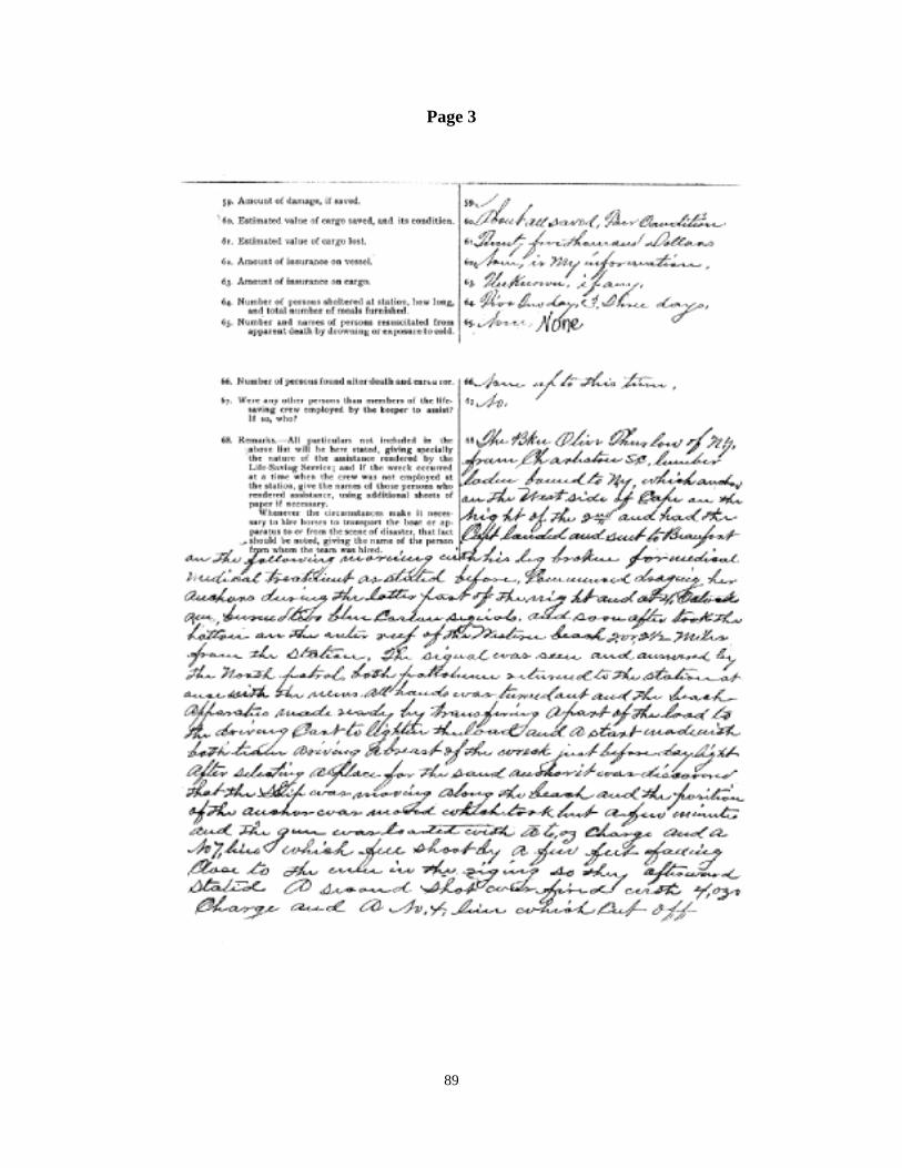
Page 3
89

Page 4
90

Page 5
91

Page 6
92

93

Apendix B: 1902 Record of American and Foreign Shipping
This is an official record of shipping for the year 1902, listing the Olive Thurlow and giving much information concerning dimintions, tonnage, repairs, dates and more.
Courtesy Nathan R. Lipfert, Library Director, Maine Maritime Museum and Richard Lawrence, Head, NC Underwater Archaeology Unit.
94

Appendix C: List of Indigenous Wildlife on the Thurlow site. Common Name Latin Name Spadefish Cheetodipterus faber Sheepshead Archosargus probatocephalus Black Sea Bass Centropristus strata Pinfish Lagodon rhomboides Blacktip Shark Carcharhinus limbatus Nurse Shark Ginglymostoma cirratum Bull Shark Carcharhinus leucas Foureye Butterflyfish Chaetodon capistratus Gray Triggerfish Balistes Capriscus Orange Filefish Aluterus schoepfi French Angelfish Pomacanthus paru Queen Angelfish Holacanthus ciliaris Seargent Major Abudefduf saxatillis Conger Eel Anguillidae congridae Arrow Crab Stenorhynchus setrcornis Stone Crab Cancer irraratus Atlantic Stingray Dasyatis sabina Green Turtle Chelonia mydas White Grunt Haemuion plumieri Blue Crab Callinectes sapidus Spiney Dogfish Squalus acanthias Smooth Dogfish Mustelus canis Yellowfin Tang Acanthurus nigraicans Common Sea Urchin Echinometra mathaei Atlantic Croaker Micropogon undulatus Summer Flounder Paralichthys dentatus Cobia Rachycentron canadum Please Note: This list is not exhaustive and does not constitute a complete list of the Thurlow's vast ecosystem. These are only organisms noticed during the course of our survey. A complete biological identification is a project I leave for someone else to conduct.
95

Appendix D: Description of the Surface Interval Diving Company
At the beginning of the "Olive Thurlow" project, our work was thought of as a one time deal, in which we would investigate a site for the benefit of the State of North Carolina and the general public. I and then Assistant Director John Dorgan, soon realized we would need help to accomplish our goals. Soon several more divers joined the team, including now Vice President David Pope and Lab Technician Mike Milton. Things went better, but financial constraints and more needed personnel problems bogged us down a bit, so we opted to add even more people to the team. At the same time, most of us began to change our frame of mind concerning marine archaeology. Our work awakened us to the importance of archaeology verses sport diving. (Many sport divers love to loot or remove artifacts from a site for a variety of reasons. Most feel that the state and federal archaeologists are not really interested in recovering the artifacts for public display, but rather enjoy denying the public access to these sites in order to feel some kind of "power trip". Nothing could be farther from the truth!) As our mindset changed, we began to shed the persona of sport divers and became "amateur archaeologists". Suddenly we were part of a bigger picture that emphasizes benefit to the public, not just ourselves. Suddenly it really was important why that timber fell the way it did or why we take wood samples. It was important to measure and map and draw and record. Suddenly the Thurlow had a soul or spirit...and a story to tell. As we became more dedicated to archaeology, we found out about the benefits of "going nonprofit". Our team was growing to12 divers and several boats and we needed to take a further step. On January 6, 1996, we founded the Surface Interval Diving Company and incorporated with the State of North Carolina. Eight months later, we received our federal 501(c)3 nonprofit status for tax exemption. The SURFACE INTERVAL DIVING COMPANY is a nonprofit 501(c)3 corporation dedicated to the proper archaeological survey, recovery, preservation, documentation, interpretation and publication of historic shipwrecks and submerged sites for the purpose of public display, education and enjoyment. SIDCo works in close cooperation with the State of North Carolina Department of Cultural Resources, the NC Underwater Archaeology Unit, the NC Maritime Museum and the National Park Service. As with any company, people come and go, and some have left SIDCo to pursue other interests. SIDCo maintains a team of 15 divers and surface personnel. SIDCo is open to the public for persons who are certified for the particular position. SIDCo personnel must be dedicated to proper archaeology, strict safety standards and some hard work. SIDCo is publicly funded and at times those funds are short, however, equipment and moneys are regularly donated to the company and we are always able to pay the bills (by the grace of the Lord). SIDCo will continue to work into the future to survey, recover and document our maritime past.
96

97