the role of the international maritime organization in...
TRANSCRIPT

Marine Policy 36 (2012) 1221–1233
Contents lists available at SciVerse ScienceDirect
Marine Policy
0308-59
http://d
Abbre
Mutual-
pact Dis
of the M
Regulat
INMARS
prehens
tion of
Safety C
on Safet
Oceano
for the
American Corr
E-m
journal homepage: www.elsevier.com/locate/marpol
The role of the International Maritime Organization in reducing vessel threatto whales: Process, options, action and effectiveness
Gregory K. Silber a,n, Angelia S.M. Vanderlaan b,c, Ana Tejedor Arceredillo d, Lindy Johnson e, ChristopherT. Taggart b, Moira W. Brown f,g, Shannon Bettridge a, Ricardo Sagarminaga d,h
a Office of Protected Resources, NOAA National Marine Fisheries Service, 1315 East West Highway Silver Spring, MD 20910, USAb Department of Oceanography, Dalhousie University, Halifax, NS, Canada B3H 4R2c Fisheries and Oceans Canada, St. Andrews Biological Station, 531 Brandy Cove Road, St. Andrews, NB, Canada E5B 2L9d KAI Marine Services, Nalon, 16, La Berzosa, 28240 Hoyode Manzanares, Madrid, Spaine General Counsel for Office of International Law, National Oceanic and Atmospheric, Administration, 14th & Constitution, N.W., Washington, DC, 20230, USAf New England Aquarium, Boston, MA, 02110, USAg Canadian Whale Institute, Box 410, Wilson’s Beach, NB, Canada E5E 1Y2h ALNITAK Marine Environment Research Center, Nalon, 16, La Berzosa, 28240 Hoyode Manzanares, Madrid, Spain
a r t i c l e i n f o
Article history:
Received 24 June 2011
Received in revised form
6 February 2012
Accepted 11 March 2012Available online 15 May 2012
Keywords:
International Maritime Organization
Whale
Vessel
Ship
Strike
Risk
7X/$ - see front matter Published by Elsevier
x.doi.org/10.1016/j.marpol.2012.03.008
viations: AIS, Automatic Identification Sy
Assistance Vessel Rescue System; ATBA, Area
c; DGMM, Direccion General de la Marina M
erchant Marine); ECAREG, Eastern Canada V
ions; GT, Gross tonnage; IMO, International M
AT, International Marine/Maritime Satellite;
ive Ocean-Atmosphere Data Set; IUCN, Intern
Nature; MEPC, Marine Environment Protectio
ommittee; MSR, Mandatory Ship Reporting sy
y of Navigation; NMFS, National Marine Fishe
graphic and Atmospheric Administration; SOL
Safety of Life at Sea; TSS, Traffic Separation Sc
; USCG, United States Coast Guard; VOS, Vol
esponding author. Tel.: þ1 301 427 8485.
ail address: [email protected] (G.K. Silber)
a b s t r a c t
Ocean-going vessels present a measurable threat of lethal collision with many marine species
worldwide, notably large whale species of which many are endangered. Various modifications to
conventional vessel operations have been recently used to reduce the threat. Some of the modifications
have been instituted by coastal states as a result of their adoption by the International Maritime
Organization (IMO) — a specialized agency of the United Nations that is the recognized authority for
international maritime shipping interests and their safety of navigation at sea. We describe the
processes through which coastal states can approach the IMO to seek review and adoption of
environmental conservation proposals involving international shipping. We also provide a description
of vessel navigation modifications in specific geographic areas where IMO-adopted measures to protect
large whales have been implemented — there are only 10 such cases and we describe each. We then
address the methods that can and have been used to assess the effectiveness of such measures. As
weighed against the goals of the modifications by estimating the ensuing reduced risk to whales,
actions taken are generally regarded as being successful in reducing the risk, but to varying degrees. We
conclude that the IMO can be a powerful entity in providing solutions to a range of marine
environmental and conservation problems. When used in concert with related efforts such as mariner
education, the IMO, and the range of navigational measures available to it, is an effective forum through
which coastal states can pursue large whale conservation objectives without unduly compromising the
activities of shipping interests.
Published by Elsevier Ltd.
Ltd.
stem; AMVER, Automated
To Be Avoided; CD, Com-
ercante (Directorate General
essel Traffic Services Zone
aritime Organization;
ICOADS, International Com-
ational Union for Conserva-
n Committee; MSC, Marine
stems; NAV, Sub-Committee
ries Service; NOAA, National
AS, International Convention
heme; USA, United States of
untary Observing Ships
.
1. Introduction
Worldwide, a number of marine species including sea turtles[1,2], manatees [3,4], small whales [5], and all large whales [6,7] arekilled or injured by vessel strikes. As of 2007, there were �750records of vessels striking large whales worldwide [8]. This repre-sents a minimum count as an unknown number of vessel strikes goundetected or unreported. When whale carcasses are recovered andexamined, the cause of death is often indeterminate [9,10], due, forexample, to advanced decomposition or no external evidence of avessel strike. For some endangered species, such as the NorthAtlantic right whale (Eubaelana glacialis), vessel strikes are a mea-surable impediment to the recovery of the species [11,12]. A highproportion of dead right whales show signs attributable to vesselstrike including severe lacerations, broken bones, internal hemor-rhaging and other lethal forms of blunt trauma [9,13].
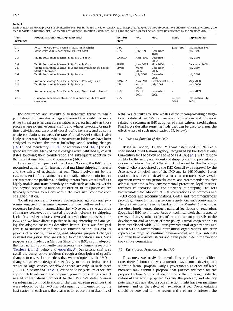
Table 1Table of text-referenced proposals submitted by Member States and the dates considered and approved/adopted by the Sub-Committee on Safety of Navigation (NAV), the
Marine Safety Committee (MSC), or Marine Environment Protection Committee (MEPC) and the date proposed actions were implemented by the Member State.
Textreference
Proposals submitted/adopted by IMO MemberState
NAV MSC MEPC Implemented
2.1 Report to MSC-IMO: vessels striking right whales USA – – June 1997 Information 1997
2.2 Mandatory Ship Reporting (MSR): east coast USA July 1998 December
1998
– July 1999
2.3 Traffic Separation Scheme (TSS): Bay of Fundy CANADA April 2002 December
2002
– July 2003
2.4 Traffic Separation Scheme (TSS): Cabo de Gata SPAIN June 2005 May 2006 – December 2006
2.5 Traffic Separation Scheme (TSS) and Recommendatory Speed:
Strait of Gibraltar
SPAIN March
2006
December
2006
– July 2007
2.6 Traffic Separation Scheme (TSS): Boston USA July 2006 December
2006
– July 2007
2.7 Recommendatory Area To Be Avoided: Roseway Basin CANADA April 2007 October 2007 – May 2008
2.8 Traffic Separation Scheme (TSS): Boston USA March
2008
July 2008 – June 2009
2.9 Recommendatory Area To Be Avoided: Great South Channel USA March
2008
December
2008
– June 2009
2.10 Guidance document: Measures to reduce ship strikes with
cetaceans
USA August
2008
Information July
2009
G.K. Silber et al. / Marine Policy 36 (2012) 1221–12331222
The occurrence and severity of vessel-strike threat to whalepopulations in a number of regions around the world has madestrike threat an emerging conservation issue, particularly in thoseplaces where extensive vessel traffic and whales co-occur. As mari-time activities and associated vessel traffic increase, and as somewhale populations increase, the rate of lethal vessel-strikes is alsolikely to increase. Various whale-conservation initiatives have beendesigned to reduce the threat including vessel routing changes[14–17] and mandatory [18–20] or recommended [14,15] vessel-speed restrictions. Many of these changes were instituted by coastalstates following their consideration and subsequent adoption bythe International Maritime Organization (IMO).
As a specialized agency of the United Nations, the IMO is therecognized authority for international maritime shipping interestsand the safety of navigation at sea. Thus, involvement by theIMO is essential for ensuring internationally coherent solutions tovarious maritime problems, including threats from vessel traffic tohighly mobile and trans-boundary animals such as whales, withinand beyond regions of national jurisdiction. In this paper we aretypically referring to regions within the Exclusive Economic Zoneof a given nation.
Not all research and resource management agencies and per-sonnel engaged in marine conservation are well-versed in theprocesses involved in approaching the IMO to secure the adoptionof marine conservation-oriented proposals relevant to shipping.Each of us has been closely involved in developing proposals to theIMO, and we have direct experience in implementing and analyz-ing the adopted measures described herein. Thus, our first goalhere is to summarize the role and function of the IMO and itsprocess of receiving, reviewing, and adopting proposed changesin vessel navigation that are related to conservation issues. Suchproposals are made by a Member State of the IMO, and if adopted,the host nation subsequently implements the change domestically(Sections 1.1, 1.2, below and Appendix A). Our second goal is todetail the vessel strike problem through a description of specificchanges to navigation practices that were adopted by the IMO —
changes that were designed specifically to reduce lethal vesselstrikes to large whales. Worldwide there are only 10 such cases(1.3, 1.4, 2, below and Table 1). We do so to help ensure others areappropriately informed and prepared prior to presenting a vesselrelated conservational proposal to the IMO. We detail variousvessel-navigation modifications of the then existing practices thatwere adopted by the IMO and subsequently implemented by thehost nation. In each case, the goal was to reduce the probability of
lethal vessel strikes to large whales without compromising naviga-tional safety at sea. We also review the timelines and processesrelated to securing an IMO adoption of a navigational modification.Finally, we describe some methods that can be used to assess theeffectiveness of such modifications (3, below).
1.1. Role and function of the IMO
Based in London, UK, the IMO was established in 1948 as aspecialized United Nations agency, recognized by the InternationalConvention for the Safety of Life at Sea (SOLAS) [21], with respon-sibility for the safety and security of shipping and the prevention ofmarine pollution. The IMO Secretariat is headed by the Secretary-General who is appointed by the IMO Council with approval by theAssembly. A principal task of the IMO and its 169 Member States(nations) has been to develop a suite of comprehensive vessel-operation conventions, protocols, codes, and recommendations thataddress maritime safety, environmental protection, legal matters,technical co-operation, and the efficiency of shipping. The IMOhas promoted the adoption of �40 conventions and protocols and�800 codes and recommendations. Codes and recommendationsprovide guidance for framing national regulations and requirements.Though they are not usually binding on the Member States, codesare often implemented through national legislation or regulation.Specialized IMO committees focus on technical work that is used toreview and advise other, or ‘parent’, committees on proposals, or thedevelopment and adoption of new policy. Formal cooperation hasbeen established with �30 inter-governmental organizations andalmost 50 non-governmental international organizations. The latterrepresent a range of maritime, environmental, and legal interestsand often have observer status and often participate in the work ofthe various committees.
1.2. The process: Proposals to the IMO
To secure vessel-navigation regulations or policies, or modifica-tions thereof, from the IMO, a Member State must develop andsubmit a formal proposal. Only a government, or other affiliatedmember, may submit a proposal that justifies the need for theproposed action. A proposal must describe the problem, justify thenature of the action proposed to solve the problem, and identifypotentially adverse effects such an action might have on maritimeinterests and on the safety of navigation at sea. Documentationshould be provided for the region and problem of interest, the
G.K. Silber et al. / Marine Policy 36 (2012) 1221–1233 1223
associated nature of the vessel traffic (density, routes used, etc.),the status of neighboring states regarding the region of interest andthe proposed action, and existing navigational rules, regulationsand (or) policies associated with the region. Proposals related toenvironmental issues are typically reviewed and endorsed (or not)by IMO committees that may include the Marine EnvironmentProtection Committee (MEPC), the Sub-Committee on Safety ofNavigation (NAV), and the Marine Safety Committee (MSC). Thelatter two are engaged when proposals involve navigation andmarine safety.
In all cases, the solicitation of an IMO endorsement for aproposed action must be founded on the soliciting Member Statehaving already endorsed the proposal. As most proposed actionsrelating to navigation lie partly or wholly within territorial watersor Exclusive Economic Zones [22], IMO endorsement is generallypreceded or followed by action involving rule making authoritiesand regulatory instruments or policies such as declarations orlegislation. As in the actions taken and measures discussed below,proposals emanating from the United States of America (USA)require interagency clearance and are submitted to the IMO bythe US Coast Guard (USCG) on behalf of the USA government. InCanada, responsibility lies with Transport Canada, and in Spainwith the Direccion General de la Marina Mercante (DGMM).
1.3. The problem: Vessels striking large whales
To our knowledge, 10 specific actions have been endorsed bythe IMO to reduce the likelihood of vessels striking and killing orinjuring large whales, and with one exception, they are limitedto four whale species and three geographic regions: the NorthAtlantic right whale (hereafter, right whale) along the easternseaboard of the USA and the Scotia-Fundy region of Canada, andthe fin (Balaenoptera physalus), sperm (Physeter macrocephalus),and long-finned pilot (Globicephala melas) whales in the westernMediterranean Sea. In each case, we provide a brief summaryof whale occurrence and distribution in these regions and themagnitude of the threat they face from vessel strikes. The excep-tion is a general, but relevant, international guidance documentthat addresses vessel strikes to whales.
1.4. Northwest Atlantic
The right whale is a large baleen whale and is among the mostendangered of the large whales. It was severely exploited duringcommercial whaling and is listed as ‘endangered’ by the Interna-tional Union for the Conservation of Nature, (IUCN) [23], the USAEndangered Species Act, and the Canadian Species at Risk Act.Although estimates of abundance vary, most authors agree thewestern North Atlantic population consists of �300–450 individuals.
Right whales inhabit the coastal shelf-waters of eastern NorthAmerica, although a few oceanic movements are documented.Most individuals migrate annually between wintering, calving,and nursery areas off the southeastern USA and summer feedinghabitats off New England in the USA and in the Bay of Fundy andon the southwest Scotian Shelf in Canada. Five primary habitatsinclude the southern calving and nursery grounds off Florida andGeorgia, Cape Cod Bay, the Great South Channel east of Cape Cod,the Bay of Fundy, and Roseway Basin [24]. Each of these habitatsis intersected by highly concentrated vessel traffic.
Vessel strikes account for 53% of all right whale deaths diag-nosed from necropsies [13]. Probability estimates of deaths fromvessel strikes, based largely on Moore et al. [9] and Kraus et al.[11], could be as high as 10 individuals in any given year [25].Of the 50 documented right whale deaths occurring between1986 and 2005, 19 were attributed to vessel strikes [11]. Anaverage of two or more known North Atlantic right whale deaths
and serious injuries from vessel strikes occurred annually for thelast decade [10,26]. Based on existing records [7,27], and on a per-capita basis, the right whale is two orders of magnitude morelikely to suffer a vessel strike than any other large whale species[28]. Right whale vulnerability to vessel strikes is likely related totheir coastal distribution that exposes them to high-density vesseltraffic [29] and their apparent lack of avoidance of oncomingvessels [30,31]. The endangered status of the right whale andthe magnitude of lethal vessel-strike risk led the governments ofthe USA and Canada, in concert with various non-governmentalorganizations, to seek ways to minimize the risk of vessel-strikesto whales.
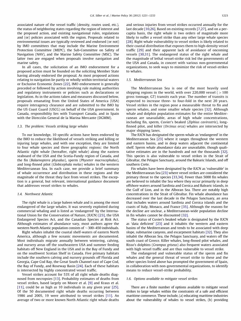
1.5. Mediterranean Sea
The Mediterranean Sea is one of the most heavily usedshipping regions in the world, with over 220,000 vessel (4100gross tonnage, GT) transits each year. The number of transits isexpected to increase three- to four-fold in the next 20 years.Vessel strikes in the region pose a measurable threat to fin andsperm whales, and some smaller whale species [32]. Althoughwhale and dolphin population estimates for the entire Mediter-ranean are unavailable, areas of high whale concentrations,including fin, sperm, Cuvier’s beaked (Ziphius cavirostris), long-finned pilot, and killer (Orcinus orca) whales are intersected bymajor shipping lanes.
The IUCN has designated the sperm whale as ‘endangered’ in theMediterranean Sea [23] where it ranges throughout the westernand eastern basins, and in deep waters adjacent the continentalshelf. Sperm whale abundance data are unavailable, though quali-tative estimates are in the hundreds and not the thousands [32].This species is also vulnerable to vessel strikes in the Strait ofGibraltar, the Pelagos Sanctuary, around the Balearic Islands, and offsouthern Crete.
Fin whales have been designated by the IUCN as ‘vulnerable’ inthe Mediterranean Sea [23] where vessel strikes are considered theprimary threat to the species [33,34]. Fewer than 5000 fin whalesare believed to inhabit the Sea where they occur primarily in deepoffshore waters around Sardinia and Corsica and Balearic islands, inthe Gulf of Lion, and in the Alboran Sea. There are notably highconcentrations in the Strait of Gibraltar. Fin whale abundance hasdecreased over the last decade in the Pelagos Sanctuary, an areathat includes waters around Sardinia and Corsica islands and thecoasts of Italy, Monaco, and France [35]. Although the reasons forthe decline are unclear, a Mediterranean-wide population declinein fin whales cannot be discounted [32].
The status of Cuvier’s beaked whale is designated by the IUCNas ‘data deficient’ [23] and it inhabits the western and easternbasins of the Mediterranean and tends to be associated with deepslope, submarine canyons, and escarpment habitats [32]. They alsoinhabit the Alboran Sea, the Pelagos Sanctuary, and waters off thesouth coast of Greece. Killer whales, long-finned pilot whales, andRisso’s dolphins (Grampus griseus) also frequent waters associatedwith high vessel traffic and are thus vulnerable to vessel strike.
The endangered and vulnerable status of the sperm and finwhales and the general threat of vessel strike to these and theother species listed above has prompted the government of Spain,in collaboration with non-governmental organizations, to identifymeans to reduce vessel-strike probability.
1.6. Options available to mitigate vessel strikes
There are a finite number of options available to mitigate vesselstrikes to large whales within the constraints of a safe and efficientmaritime commerce. These include, (a) educating maritime industriesabout the vulnerability of whales to vessel strikes, (b) providing

G.K. Silber et al. / Marine Policy 36 (2012) 1221–12331224
whale location information to mariners to increase their awarenessand preparedness to avoid whales, (c) establishing time and (or) area-specific vessel-speed restrictions to minimize the likelihood oflethality of a strike should it occur, and (d) establishing time and(or) area-specific modifications to vessel-traffic routing to minimizethe probability of a strike occurring.
There is little evidence that extensive mariner education, (a),or the provision of whale locations, (b), results in modified marinerbehavior with regard to reducing vessel strikes. Both types of infor-mation require that mariners receive and heed the advisoriesprovided, choose to take voluntary actions (that may be inconsistentamongst vessel operators), and perhaps engage in avoidancemaneuvers (that may not be feasible in all situations) [28,36].Nonetheless, we suggest it is essential to foster and maintain
Fig. 1. Right whale Mandatory Ship Reporting systems (MSR) in waters off New Engla
Separation Scheme (TSS) in the approach to Boston (a). The TSS was modified follow
narrowing of both the north-south and east-west legs.
a constructive flow of information among the various conser-vation agencies and vessel operators. Building mutual respectand trust between vessel operators and those agencies andorganizations engaged in providing such information is crucialto the execution of successful conservation initiatives while alsomaintaining the safety of navigation at sea. Such relationshipsmay also help foster development of innovative approaches tochallenging conservation problems.
There is reliable evidence that vessel speed restrictions, (c), canreduce the forces involved in [29] and the probability of deathresulting from [28] a vessel strike. Speed restrictions may limitstrike severity, but they may have concurrent negative time-related economic consequences. There is also reliable evidencethat modified traffic routing, (d), reduces vessel strike probabilities
nd (a) and the southeast USA (b). Also shown is the original and modified Traffic
ing adoption by the IMO, including a 12 degree shift of the northern leg and a

G.K. Silber et al. / Marine Policy 36 (2012) 1221–1233 1225
[17,25], though modifications may not be feasible in some regionsdue to safe-navigation constraints. Nonetheless, eliminating orreducing the extent of vessel and whale coincidence in time andspace is assured to reduce the likelihood of a vessel strike and thusit is preferable, where possible, to vessel-speed restrictions. Giventhe evidence that modified vessel operations can reduce vesselstrikes and (or) their severity, it is incumbent upon conservationagencies to draw upon the IMO and its numerous navigationinstruments. The global reach of the IMO makes it an optimumforum for considering proposals to minimize vessel strikes towhales.
Fig. 2. Standardized (comparable scale) residual risk of lethal collision between a
vessel and a right whale associated with the original and amended (solid black
line) Bay of Fundy Traffic Separation Scheme (TSS). The original (solid black line)
TSS is also shown (b) with a hypothetical 10 knot speed restriction imposed over
the entire study area. Negative residuals indicate reduced risk. 100 m isobaths are
indicated. Modified from Vanderlaan et al. [16].
2. Proposals adopted by the IMO to mitigate vessel strikes
The IMO has been approached 10 times (Table 1) withindependent submissions by three nations seeking a reductionof vessel strikes to whales in three geographic regions. Here wesummarize these submissions in chronological order of theirsubmission, the actions taken by the IMO, and the actions takenby relevant Member states. To orient the reader – particularlyresource management personnel and policymakers – about thesuite of navigational instruments available to the IMO, we providea listing and a brief definition of each in Appendix A.
2.1. Information paper: Vessels striking right whales, USA (1997–1998)
The IMO was first approached about the problem of vesselstrikes to right whales in 1997. Recognizing the significance ofvessel strikes to the whales, the USA developed and submitted aninformation paper [37] to the IMO-MEPC in June 1997 [38].Developed collaboratively by the US Marine Mammal Commis-sion, the National Oceanic and Atmospheric Administration(NOAA) and the USCG, the paper identified and detailed thethreat of vessel strikes to right whales. The paper asked that theIMO distribute the paper and called upon IMO member states toinform their respective shipping interests about the issue andprovide relevant information on vessel strikes to NOAA’s NationalMarine Fisheries Service (NMFS), the agency responsible for theconservation right whales in the USA. The IMO acted accordinglyand this laid the groundwork for the possible and subsequentreduction of vessel strikes under the auspices of the IMO.
2.2. Mandatory ship reporting (MSR): East coast, USA (1998–1999)
In June 1998 the USA followed the 1997 information paperwith a proposal to the IMO [39], prepared jointly by the USCG andNOAA, seeking the establishment of two Mandatory Ship Report-ing systems (MSR) (Appendix A) in regions of right whaleaggregations in USA waters. The systems were to provide infor-mation (about whales and their vulnerability to vessel strike)directly to individual vessels in near real-time when they enteredthe defined regions [40–42]. The proposal had been endorsed byPresident Clinton in April 1998 [40].
Under the proposed measure, all commercial vessels Z300 GTwould be required to report to shore-based stations when theyentered either of two regions off the east coast of the USA [39,40]where and when right whales were known to occur: one off thestate of Massachusetts (Fig. 1(a)) operating year-round, and one offthe states of Georgia and Florida (Fig. 1(b)) operating annually from15 November through 15 April. Each vessel-crew would be requiredto report the vessel name, call sign, course, speed, location, destina-tion, and route (waypoints). In return, the vessel would immediatelyreceive updated information concerning right whale locations, aswell as procedural guidance to help prevent a vessel strike. Marinerswould be advised to consult navigational publications such as the
US Coast Pilot, Sailing Directions (an international shipping guide),and nautical charts for information on regulations and boundaries ofright whale critical habitat. Mariners would be further advised thatinformation placards, CDs, and other educational materials areavailable from shipping agents, port authorities, relevant stateagencies, the USCG, and NMFS. Mariners would also be advised thatupdated information on right whales locations would be availablethrough the broadcast media, including the USCG Broadcast toMariners, satellite-linked marine safety broadcasts, and NOAAWeather Radio. The reporting system would affect no other aspectof vessel operation and all two-way communication costs were to be

G.K. Silber et al. / Marine Policy 36 (2012) 1221–12331226
borne by the USCG and NMFS. The primary communication systemis via INMARSAT-C (satellite) for the majority of vessels, and thusthe information would be received in near real-time. In return, theMSR systems would provide NMFS with data concerning numberand operations (e.g., courses, speeds etc.) of vessels transiting theregion [43]. The data would be used to assess and consideradditional or modified mitigation options (e.g., [44,45]).
The two MSR systems, reviewed by the NAV for recommenda-tions to the MSC [41], were approved in July 1998, and adopted bythe MSC in December 1998 [46]. Following adoption by the IMO,the systems became effective on 1 July 1999 and have remainedin effect as designed to the present. This was the first time anIMO-endorsed measure was used to protect a particular marinespecies [41]. Subsequently, the USCG issued a Final Rule in theUSA Federal Register codifying the systems by modifying the USACode of Federal Regulations [47] and the MSR areas wereincorporated into USA nautical charts by NOAA.
2.3. Traffic Separation Scheme (TSS): Bay of Fundy, Canada
(2002–2003)
A TSS (Appendix A) was established in the Bay of Fundy, toorganize traffic through fishing grounds and to enhance the safetyof vessels traveling to and from the entrance to the Bay and thePort of Saint John, New Brunswick. The TSS was originally adoptedby the IMO in 1982 [48] and established in June 1983 (Fig. 2(a)).However, the outbound lane of the TSS intersected a Right WhaleConservation Area in the Grand Manan Basin that had beencreated to identify an area in which summer/fall right whaleaggregations occur (2.7 below). Therefore, non-governmentalmembers of the North Atlantic Right Whale Recovery Implemen-tation Team successfully petitioned Transport Canada to submit aproposal to the IMO to amend the TSS with the goal of reducingthe probability of vessel strikes in the Basin [49,50]. The proposalwas considered by the IMO-NAV in July 2002 [51], approved andforwarded by NAV to the IMO-MSC in July 2002, and adopted bythe MSC in December 2002 [52]. The TSS was modified on 1 July2003. The amendment included a relocation of the northernextent of the TSS by 3.9 nm to the east with a re-alignmenttoward the Port of Saint John, and the establishment of an entry/
Fig. 3. The original and the modified Alboran Sea Traffic Separation Scheme (TSS
exit TSS junction north of the Basin for traffic navigating to andfrom the Canada and USA ports to the west (Fig. 2(a)). The changewas published in Notices to Mariners and incorporated intoCanadian Hydrographic Services nautical charts.
2.4. Traffic Separation Scheme (TSS): Cabo de Gata, Spain
(2005–2006)
The Cabo de Gata (Cape Gata) region of the western Mediterra-nean is situated in the Alboran Sea bordered by Spain, Algeria, andMorocco. The coastal area is protected under Spanish law as a marinereserve, a nature reserve, and site of European interest (Natural Parkof Cabo de Gata–Nijar). It is also a Special Area of Conservation forCetaceans in the Mediterranean Sea [32,53,54]. However, the areawas intersected by the Cabo de Gata TSS, established in 1998 [46],that annually directed �35,000 vessel transits to and from the Straitof Gibraltar and ports along the northern coast of the Mediterranean(Fig. 3). The TSS also intersected rarely-used fishing grounds untilaround 2001 when increased bottom trawling activities increased therisk of vessel collisions. At the same time, maritime traffic authoritiesbecame increasingly concerned with high traffic volume in relationto the sensitive coastal and marine habitats designated as Sites ofCommunitary Importance (European Union Habitat Directive) and inrelation to the numbers of cetacean species and loggerhead seaturtles (Caretta caretta) that occur in the region.
In May 2005 the Spanish DGMM submitted a proposal to theIMO that was designed to first reduce the risk of collision betweenvessels using the TSS and the increased numbers of fishing vessels,and second to enhance environmental protection. The proposalsought a modification of the Cabo de Gata TSS such that it wouldlie 20 nm seaward of the Cape (Fig. 3). The proposal was adopted bythe NAV [55], then by the MSC in the same year [56], and came intoeffect on 1 December 2006 [57] along with a publication in Noticesto Mariners and incorporation into nautical charts [58].
2.5. Traffic Separation Scheme (TSS) & recommended speeds:
Strait of Gibraltar, Spain (2006–2008).
The 7-nm (13 km) wide Strait of Gibraltar provides the only directconnection between the Mediterranean Sea and the Atlantic Ocean.
). Vessel locations (derived from AIS studies) are shown in the revised TSS.
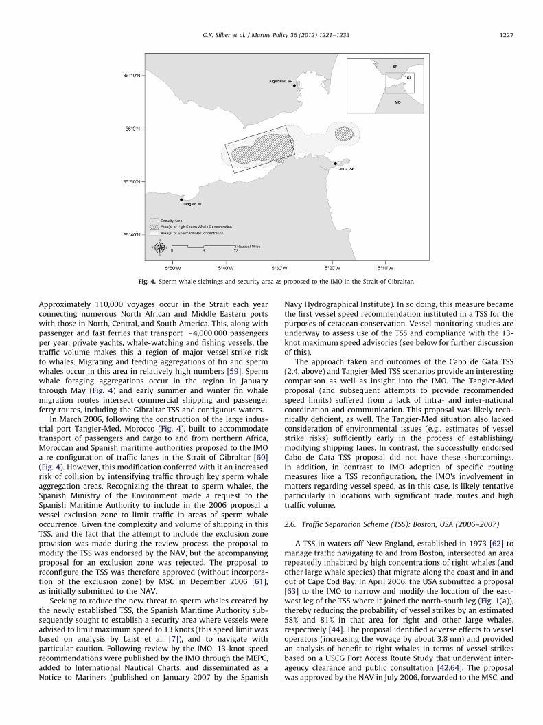
Fig. 4. Sperm whale sightings and security area as proposed to the IMO in the Strait of Gibraltar.
G.K. Silber et al. / Marine Policy 36 (2012) 1221–1233 1227
Approximately 110,000 voyages occur in the Strait each yearconnecting numerous North African and Middle Eastern portswith those in North, Central, and South America. This, along withpassenger and fast ferries that transport �4,000,000 passengersper year, private yachts, whale-watching and fishing vessels, thetraffic volume makes this a region of major vessel-strike riskto whales. Migrating and feeding aggregations of fin and spermwhales occur in this area in relatively high numbers [59]. Spermwhale foraging aggregations occur in the region in Januarythrough May (Fig. 4) and early summer and winter fin whalemigration routes intersect commercial shipping and passengerferry routes, including the Gibraltar TSS and contiguous waters.
In March 2006, following the construction of the large indus-trial port Tangier-Med, Morocco (Fig. 4), built to accommodatetransport of passengers and cargo to and from northern Africa,Moroccan and Spanish maritime authorities proposed to the IMOa re-configuration of traffic lanes in the Strait of Gibraltar [60](Fig. 4). However, this modification conferred with it an increasedrisk of collision by intensifying traffic through key sperm whaleaggregation areas. Recognizing the threat to sperm whales, theSpanish Ministry of the Environment made a request to theSpanish Maritime Authority to include in the 2006 proposal avessel exclusion zone to limit traffic in areas of sperm whaleoccurrence. Given the complexity and volume of shipping in thisTSS, and the fact that the attempt to include the exclusion zoneprovision was made during the review process, the proposal tomodify the TSS was endorsed by the NAV, but the accompanyingproposal for an exclusion zone was rejected. The proposal toreconfigure the TSS was therefore approved (without incorpora-tion of the exclusion zone) by MSC in December 2006 [61],as initially submitted to the NAV.
Seeking to reduce the new threat to sperm whales created bythe newly established TSS, the Spanish Maritime Authority sub-sequently sought to establish a security area where vessels wereadvised to limit maximum speed to 13 knots (this speed limit wasbased on analysis by Laist et al. [7]), and to navigate withparticular caution. Following review by the IMO, 13-knot speedrecommendations were published by the IMO through the MEPC,added to International Nautical Charts, and disseminated as aNotice to Mariners (published on January 2007 by the Spanish
Navy Hydrographical Institute). In so doing, this measure becamethe first vessel speed recommendation instituted in a TSS for thepurposes of cetacean conservation. Vessel monitoring studies areunderway to assess use of the TSS and compliance with the 13-knot maximum speed advisories (see below for further discussionof this).
The approach taken and outcomes of the Cabo de Gata TSS(2.4, above) and Tangier-Med TSS scenarios provide an interestingcomparison as well as insight into the IMO. The Tangier-Medproposal (and subsequent attempts to provide recommendedspeed limits) suffered from a lack of intra- and inter-nationalcoordination and communication. This proposal was likely tech-nically deficient, as well. The Tangier-Med situation also lackedconsideration of environmental issues (e.g., estimates of vesselstrike risks) sufficiently early in the process of establishing/modifying shipping lanes. In contrast, the successfully endorsedCabo de Gata TSS proposal did not have these shortcomings.In addition, in contrast to IMO adoption of specific routingmeasures like a TSS reconfiguration, the IMO’s involvement inmatters regarding vessel speed, as in this case, is likely tentativeparticularly in locations with significant trade routes and hightraffic volume.
2.6. Traffic Separation Scheme (TSS): Boston, USA (2006–2007)
A TSS in waters off New England, established in 1973 [62] tomanage traffic navigating to and from Boston, intersected an arearepeatedly inhabited by high concentrations of right whales (andother large whale species) that migrate along the coast and in andout of Cape Cod Bay. In April 2006, the USA submitted a proposal[63] to the IMO to narrow and modify the location of the east-west leg of the TSS where it joined the north-south leg (Fig. 1(a)),thereby reducing the probability of vessel strikes by an estimated58% and 81% in that area for right and other large whales,respectively [44]. The proposal identified adverse effects to vesseloperators (increasing the voyage by about 3.8 nm) and providedan analysis of benefit to right whales in terms of vessel strikesbased on a USCG Port Access Route Study that underwent inter-agency clearance and public consultation [42,64]. The proposalwas approved by the NAV in July 2006, forwarded to the MSC, and

Fig. 5. The Roseway Basin Area To Be Avoided (ATBA) (black polygon) in (a) and
(b) and vessel tracks through the region from 15 June to 31 October 2007 (a) and
from 1 June to 31 October 2008 (b) prior to and following implementation of the
ATBA, respectively. Modified from Vanderlaan and Taggart [17].
G.K. Silber et al. / Marine Policy 36 (2012) 1221–12331228
adopted by the IMO in December 2006. The amended TSS wentinto effect on 1 July 2007 [57]. The amendment was addedto NOAA navigational charts and the USCG updated its list ofoffshore traffic separation schemes and precautionary areas in theUSA Code of Federal Regulations.
2.7. Area to Be Avoided: Roseway Basin, Canada (2007–2008)
In addition to the Grand Manan Basin in the Bay of Fundy, rightwhales also aggregate annually in the Scotian Shelf’s Roseway Basinthat is intersected by vessels transiting through Shelf waters and toand from the approaches to New York City and other ports in theUSA (Fig. 5). The traffic posed a measurable risk of lethal vesselstrike to right whales [16,64]. In 2006, non-governmental membersof the North Atlantic Right Whale Recovery Implementation Teamonce again successfully petitioned the regional and national Cana-dian Marine Advisory councils (Transport Canada) to support aproposal [65] to establish an Area To Be Avoided (ATBA) in theRoseway Basin region. Transport Canada subsequently proposedcreation of the ATBA to the IMO in July 2007 [66] when it wasapproved by the NAV, forwarded to the MSC, and adopted by theIMO in October 2007; the ATBA was implemented in May 2008. TheATBA is recommendatory for all vessels Z300 GT and is in effectannually from 1 June to 31 December. The Canadian HydrographicService incorporated the ATBA into nautical charts, the standardnotifications to mariners were issued, and Caution-to-Marinersplacards were distributed to a variety of shipping interests by thenon-governmental organization Canadian Whale Institute.
2.8. Traffic Separation Scheme (TSS): Boston, USA (2008–2009)
In March 2008 the USA submitted a proposal to the IMO for anarrowing of the north-south leg of the previously modifiedBoston TSS (2.6 above) to further separate vessels and right whaleaggregations near the TSS [45], and to make the leg consistent inwidth with the previous narrowing of the east-west leg. Theproposed amendment was approved by the NAV in March 2008[67] when it was forwarded to the MSC, adopted by the IMO inJuly 2008 [68], and it went into effect in June 2009. As above,Member States and shipping interests were notified and changeswere incorporated into navigational charts.
2.9. Area To Be Avoided: Great South Channel, USA (2008–2009)
In summer and autumn, right whale feeding aggregations arepersistent in the Gulf of Maine’s Great South Channel, an area thatincludes the existing MSR area (2.2. above), the Boston TSS (2.6 and2.8), and two heavily used but unspecified routes [43,45] withgenerally NW-SE and NE-SW orientations (Fig. 6). Given the elevatedrisk of lethal vessel strike in the region [69], the USA submitted aproposal to the IMO in March 2008 seeking the establishment of anATBA in the Great South Channel [70]. The proposal would alsoencourage increased use of the amended Boston TSS. The proposalwas approved by the NAV in March 2008, forwarded to the MSC,adopted by the IMO in December 2008, and implemented in June2009 [17]. The ATBA is recommendatory for all vessels Z300 GT andis in effect annually from 1 April through 31 July. As in all casesabove, the ATBA was incorporated into nautical charts and standardnotifications to mariners were issued.
2.10. Guidance document: Measures to reduce ship strikes with
cetaceans, USA, Spain, France, Italy, and Monaco (2008–2009)
In August 2008 the USA provided the IMO with a draft guidancedocument [68] that identified ways to minimize the risk of vesselstrikes of cetaceans globally. In October 2008, the MEPC agreed to
invite delegations to provide comments on the draft for eventualapproval by the MEPC [71]. In May 2009, Spain, in cooperation withFrance, Italy, and Monaco, presented a supporting paper [72] witha focus on the Mediterranean Sea. The Guidance Document wasapproved in July 2009 and it was issued as an MEPC circular with aninvitation for member states to bring the circular to the attention ofall interested parties, including administrations, recognized organiza-tions and shipping interests. The Document identifies general prin-ciples for member states to monitor, assess, and mitigate vessel-strikerisk in their waters. These principles, while stressing that maritimesafety is paramount, include the scientific assessment of shipping andthe affected cetacean populations, science-based risk mitigation,monitoring the effectiveness of any vessel strike reduction initiative,and mariner education and outreach programs. Cooperation at an
G.K. Silber et al. / Marine Policy 36 (2012) 1221–1233 1229
international level is also identified including coordination withrelevant international fora such as the International Whaling Com-mission that is now addressing vessel strike reduction.
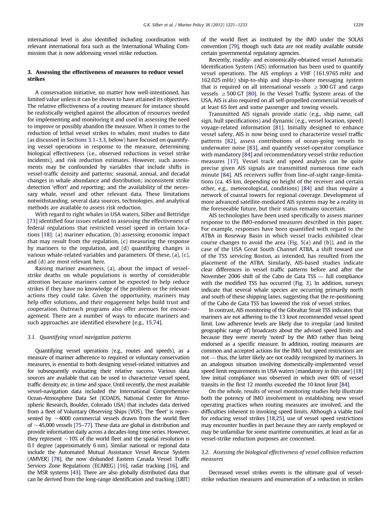
3. Assessing the effectiveness of measures to reduce vesselstrikes
A conservation initiative, no matter how well-intentioned, haslimited value unless it can be shown to have attained its objectives.The relative effectiveness of a routing measure for instance shouldbe realistically weighed against the allocation of resources neededfor implementing and monitoring it and used in assessing the needto improve or possibly abandon the measure. When it comes to thereduction of lethal vessel strikes to whales, most studies to date(as discussed in Sections 3.1–3.3, below) have focused on quantify-ing vessel operations in response to the measure, determiningbiological effectiveness (i.e., observed reductions in vessel strikeincidents), and risk reduction estimates. However, such assess-ments may be confounded by variables that include shifts invessel-traffic density and patterns; seasonal, annual, and decadalchanges in whale abundance and distribution; inconsistent strikedetection ‘effort’ and reporting; and the availability of the neces-sary whale, vessel and other relevant data. These limitationsnotwithstanding, several data sources, technologies, and analyticalmethods are available to assess risk reduction.
With regard to right whales in USA waters, Silber and Bettridge[73] identified four issues related to assessing the effectiveness offederal regulations that restricted vessel speed in certain loca-tions [18]: (a) mariner education, (b) assessing economic impactthat may result from the regulation, (c) measuring the responseby mariners to the regulation, and (d) quantifying changes isvarious whale-related variables and parameters. Of these, (a), (c),and (d) are most relevant here.
Raising mariner awareness, (a), about the impact of vessel-strike deaths on whale populations is worthy of considerableattention because mariners cannot be expected to help reducestrikes if they have no knowledge of the problem or the relevantactions they could take. Given the opportunity, mariners mayhelp offer solutions, and their engagement helps build trust andcooperation. Outreach programs also offer avenues for encour-agement. There are a number of ways to educate mariners andsuch approaches are identified elsewhere [e.g., 15,74].
3.1. Quantifying vessel navigation patterns
Quantifying vessel operations (e.g., routes and speeds), as ameasure of mariner adherence to required or voluntary conservationmeasures, is essential to both designing vessel-related initiatives andfor subsequently evaluating their relative success. Various datasources are available that can be used to characterize vessel speed,traffic density etc. in time and space. Until recently, the most availablevessel-navigation data included the International ComprehensiveOcean-Atmosphere Data Set (ICOADS, National Center for Atmo-spheric Research, Boulder, Colorado USA) that includes data derivedfrom a fleet of Voluntary Observing Ships (VOS). The ‘fleet’ is repre-sented by �4000 commercial vessels drawn from the world fleetof �45,000 vessels [75–77]. These data are global in distribution andprovide information daily across a decades-long time series. However,they represent �10% of the world fleet and the spatial resolution is0.1 degree (approximately 6 nm). Similar national or regional datainclude the Automated Mutual Assistance Vessel Rescue System(AMVER) [78], the now disbanded Eastern Canada Vessel TrafficServices Zone Regulations (ECAREG) [16], radar tracking [16], andthe MSR systems [43]. There are also globally distributed data thatcan be derived from the long-range identification and tracking (LRIT)
of the world fleet as instituted by the IMO under the SOLASconvention [79], though such data are not readily available outsidecertain governmental regulatory agencies.
Recently, readily- and economically-obtained vessel AutomaticIdentification System (AIS) information has been used to quantifyvessel operations. The AIS employs a VHF (161.9765 mHz and162.025 mHz) ship-to-ship and ship-to-shore messaging systemthat is required on all international vessels Z300 GT and cargovessels Z500 GT [80]. In the Vessel Traffic System areas of theUSA, AIS is also required on all self-propelled commercial vessels ofat least 65 feet and some passenger and towing vessels.
Transmitted AIS signals provide static (e.g., ship name, callsign, hull specifications) and dynamic (e.g., vessel location, speed)voyage-related information [81]. Initially designed to enhancevessel safety, AIS is now being used to characterize vessel trafficpatterns [82], assess contributions of ocean-going vessels tounderwater noise [83], and quantify vessel-operator compliancewith mandatory [84] and recommendatory vessel strike reductionmeasures [17]. Vessel track and speed analysis can be quiteprecise given AIS signals are transmitted numerous time eachminute [84]. AIS receivers suffer from line-of-sight range-limita-tions (ca. 45 km, depending on height of the receiver and certainother, e.g., meteorological, conditions) [84] and thus require anetwork of coastal towers for regional coverage. Development ofmore advanced satellite-mediated AIS systems may be a reality inthe foreseeable future, but their status remains uncertain.
AIS technologies have been used specifically to assess marinerresponse to the IMO-endorsed measures described in this paper.For example, responses have been quantified with regard to theATBA in Roseway Basin in which vessel tracks exhibited clearcourse changes to avoid the area (Fig. 5(a) and (b)), and in thecase of the USA Great South Channel ATBA, a shift toward useof the TSS servicing Boston, as intended, has resulted from theplacement of the ATBA. Similarly, AIS-based studies indicateclear differences in vessel traffic patterns before and after theNovember 2006 shift of the Cabo de Gata TSS — full compliancewith the modified TSS has occurred (Fig. 3). In addition, surveysindicate that several whale species are occurring primarily northand south of these shipping lanes, suggesting that the re-positioningof the Cabo de Gata TSS has lowered the risk of vessel strikes.
In contrast, AIS monitoring of the Gibraltar Strait TSS indicates thatmariners are not adhering to the 13 knot recommended vessel speedlimit. Low adherence levels are likely due to irregular (and limitedgeographic range of) broadcasts about the advised speed limits andbecause they were merely ‘noted’ by the IMO rather than beingendorsed as a specific measure. In addition, routing measures arecommon and accepted actions for the IMO, but speed restrictions arenot — thus, the latter likely are not readily recognized by mariners. Inan analogous situation involving domestically-implemented vesselspeed limit requirements in USA waters (mandatory in this case) [18]low initial compliance was observed in which over 60% of vesseltransits in the first 12 months exceeded the 10 knot limit [84].
On the whole, results of vessel monitoring studies help illustrateboth the potency of IMO involvement in establishing new vesseloperating practices when routing measures are involved, and thedifficulties inherent to invoking speed limits. Although a viable toolfor reducing vessel strikes [18,25], use of vessel speed restrictionsmay encounter hurdles in part because they are rarely employed ormay be unfamiliar for some maritime communities, at least as far asvessel-strike reduction purposes are concerned.
3.2. Assessing the biological effectiveness of vessel collision reduction
measures
Decreased vessel strikes events is the ultimate goal of vessel-strike reduction measures and enumeration of a reduction in strikes

Fig. 6. North Atlantic right whale sighting locations January 1999–July 2005 and vessel traffic patterns June 2005–May 2009 in the area that later became the Great South
Channel Area To Be Avoided. Vessel data were derived from the Mandatory Ship Reporting system data. Right whale sighting information provided courtesy of NOAA’s
Northeast Fisheries Science Center’s aerial survey program.
G.K. Silber et al. / Marine Policy 36 (2012) 1221–12331230
(e.g., documenting fewer whale deaths, or quantifying populationgrowth, the later being at least partly attributable to fewer mortal-ities; item d in Section 3, above) is one direct measure of relativesuccess. However, quantifying such reductions may not be easilyaccomplished because not all strikes are observed or reported. Pace[85] used one biological metric in assessing the effectiveness of vesselspeed limits: time elapsed between subsequent known vessel strikedeaths or serious injuries, both before and after the enactment of aspecific measure (but, this has not been applied to the IMO-endorsedmeasures discussed here). This approach helps avoid the pitfalls oftrying to assess trends in absolute numbers of whale-strike eventsgiven they are rarely and incompletely observed or reported, but it isalso constrained by requiring a sufficiently long time series andassumes the effort to detect whale deaths remains constant.
3.3. Risk reduction estimates
Risk reduction probability calculations have been used toestimate strike rates and to assess the effectiveness of variousstrike reduction measures. For example, based on strike-rateanalysis for large baleen whales, including right whales, on globaland regional bases, Vanderlaan et al. [25] reported a 3- to 4-foldincrease in the number of reported strikes worldwide from theearly 1970s to the early 2000s and estimated a 50% chance of 14or more annual vessel-strike reports worldwide between 1999and 2002. Noting that obtaining risk reduction probabilities relyon the validity of several assumptions – including a vessel strikecan occur at any time or place along a vessel route, the probabilityof a strike is small, and vessel strikes are independent events –Vanderlaan et al. [25] concluded that where sufficient data areavailable, a modeling tool they developed can be used to predictthe expected change in vessel strikes stemming from a givenconservation action in various geographic locations. Here, again,long time series (i.e., years or decades) before and after theimplementation of a conservation initiative are needed to ade-quately evaluate the action [25,73].
Estimates of risk reduction have also been applied to measuresadopted by the IMO. For example, the efficacy of the Roseway Basin
ATBA was initially uncertain because it was based on recommenda-tory actions. Indeed, adherence with its provisions was lowest in thefirst two weeks and ranged from 57% to 87%, but some learningabout the ABTA may have been involved because in the course of thefirst year compliance had stabilized at �71% [17]. The correspondingrisk reduction was estimated at 82% and, thus, Vanderlaan andTaggart [17] concluded that an IMO-adopted ATBA, although recom-mendatory, was an effective means to protect endangered whales.
In a comparison of the merits of vessel re-routing versus speedrestrictions in the Bay of Fundy, Vanderlaan et al. [16] reported a62% risk reduction versus 52% risk reduction when using vesselre-routing and speed restrictions, respectively (Fig. 2). Thus,although there is still considerable risk of lethal vessel strikeswithin the Bay, reductions in risk have been achieved withminimal effects on maritime operations.
With regard to modification of the Boston TSS, Merrick [44]provided estimates of vessel strike reduction of 58% for right whalesand an 81% reduction for other large whale species in the area (i.e.,fin, humpback (Megaptera novaeanglia), and minke (B. acutorostrata)whales) if the TSS was amended as proposed. However, post-implementation analysis of this measure has not been conducted.Canada’s proposal to the IMO to amend the Bay of Fundy TSSprovided an estimated 80% reduction in the relative probability ofa vessel encountering a right whale [16]. Further analyses (whichincluded a vessel speed term and an algorithm that ‘moved’ thosevessels transiting the original lanes into the amended lanes) indicatedan estimated average reduction in relative risk of a lethal vessel strikeof 90% relative to the TSS’s original configuration (Fig. 2(b)). Inconsidering the entire Bay of Fundy, amending the TSS reduced therisk of a lethal vessel strike by approximately 62% [16], and resultedin estimated decreases in risk of lethal strikes by 28% to minke, 27% tofin, 17% to sei (B. borealis), and 9% to humpback whales.
4. Conclusions
Actions are being taken worldwide to reduce the threat of vesselstrikes of large whales, some via endorsement by the IMO. To date,

G.K. Silber et al. / Marine Policy 36 (2012) 1221–1233 1231
the IMO has deliberated on a total of 10 actions to reduce the threatof ship strikes to large whales in three regions. Although theprocesses used by the IMO may be confusing to some, we foundthat proposals that provided strong needs statements, were accom-panied by relevant documentation, contained an assessment ofimpact to maritime industries, and included robust risk reductionanalysis were likely to be successful. Only IMO members cansubmit proposals. Consideration should be given prior to submis-sion to monitoring of the measures, and to the necessary domesticcoastal state regulations, legislation, or other mechanisms thatmight be instrumental in implementing the measures.
Specific actions described here for waters off Canada and theUSA and those in the Mediterranean share these features: sub-stantial information existed on whale occurrence and distribu-tion, thereby facilitating the establishment of specific routingmeasures relative to whale occurrence; and vessel transit pat-terns and volume were relatively easily obtained (and therefore,compliance rates and impacts to industry could be assessed).Analogous efforts in other locations (e.g., the open ocean) mayface difficulties if biological information and technological cap-abilities for tracking vessels are limited.
The technology, data, and analytical tools exist for assessingthe relative effectiveness of IMO-endorsed measures. Vessel com-pliance with IMO-endorsed measures, even for those that arerecommendatory, is generally high. The success of these measuresis likely enhanced by the existence of constructive links betweenauthorities implementing the measures and the affected maritimeshipping entities, bearing in mind that main concerns for theseentities, and that of the IMO, are safety and security at sea. Therelative success of IMO-adopted navigational measures speak tothe influence and international reach of the IMO, and make it apowerful forum for coastal states to implement whale conserva-tion measures and for addressing a range of marine environmen-tal issues, especially where shipping has been identified as athreat to the ocean environment.
Acknowledgements
We are deeply indebted to our coauthor, the late LindyJohnson, whose life and career were the definition of an unwaver-ing commitment to marine conservation. Much of what is pre-sented above would not have been possible without her guidinghand. For their support in finding vessel-strike solutions we thankG. Detweiler, E. LaRue, and M. Solosi at the USCG in the USA;I. Martın, S. Rodriguez, M. Nogueira, J. Pantoja and F. Ramos inSpain; R. Tuner at Transport Canada; and M. Palomares at theIMO. Research conducted in the Mediterranean was funded byLIFE Nature Projects numbers LIFE02NAT/E8610 and LIFE07NAT/E00732. Critical reviews by P. Openheimer, E. LaRue and anon-ymous referees helped improve this manuscript.
Appendix A
A listing of vessel navigation definitions and instruments avai-lable to International Maritime Organization (IMO) as reflected inthe annual IMO publication entitled: Ships’ Routeing.
Area To Be Avoided (ATBA): a routing measure comprising anarea where navigation is particularly hazardous or exceptionallyimportant to avoid casualties and should be avoided by all, orcertain classes, of vessels.
Deep-water route: a route which has been accurately surveyedfor clearance of sea bottom and submerged obstacles as indicatedon nautical charts.
Fairway: a lane or corridor in which no artificial island orstructure, temporary or permanent, will be permitted so thatvessels using ports will have unobstructed approaches.
Inshore traffic zone: a routing measure comprising a desig-nated area between the landward boundary of a traffic separationscheme and the adjacent coast.
Mandatory Ship Reporting System: systems used to provide,gather, or exchange information through radio reports or othermeans of communication. The information is used to provide datafor many purposes including, but not limited to, navigation safety,environmental protection, vessel traffic services, search and res-cue, weather forecasting, and prevention of marine pollution.
No anchoring area: a routing measure identifying an area whereanchoring is hazardous or could result in unacceptable damage tothe marine environment. Anchoring in a no anchoring area shouldbe avoided by all vessels or certain classes of vessels, except in caseof immediate danger to the vessel or persons on board.
Particularly Sensitive Sea Area (PSSA): an area that needsspecial protection because of its significance for recognizedecological, socio-economic, or scientific reasons and which maybe vulnerable to damage by international maritime activities. Thecriteria for the identification of a PSSA and the criteria for thedesignation of Special Areas are not mutually exclusive. In manycases a Particularly Sensitive Sea Area may be identified within aSpecial Area and vice versa.
Precautionary area: a routing measure comprising an areawithin defined limits where vessels must navigate with particularcaution and within which the direction of traffic flow may berecommended.
Recommended route: a route of undefined width, for the con-venience of vessels in transit, which is often marked by centerlinebuoys.
Recommended track: a route which has been specially exam-ined to ensure so far as possible that it is free of dangers and alongwhich vessels are advised to navigate.
Regulated Navigation Area: an area for which specific regula-tions for vessels navigating within the area have been established.
Roundabout: a routing measure comprising a separation pointor circular separation zone and a circular traffic lane. Trafficwithin the roundabout is separated by moving in a counter-clockwise direction around the separation point or zone.
Separation Zone or separation line: a zone or line separatingthe traffic lanes in which vessels are proceeding in opposite ornearly opposite directions; or from the adjacent sea area; orseparating traffic lanes designated for particular classes of vesselsproceeding in the same direction.
Traffic lane: an area in which one-way traffic is established.Natural obstacles, including those forming separation zones, mayconstitute a boundary.
Traffic Separation Scheme (TSS): a routing measure aimed atthe separation of opposing streams of traffic by appropriatemeans and by the establishment of traffic lanes. The traffic-lanes(or clearways) indicate the direction of the ships in that zone;ships navigating within a TSS all sail in the same direction or theycross the lane in an angle as close to 90 degrees as possible. TSS’sare used to regulate the traffic at busy, confined waterwaysor around capes, and usually consist of at least one traffic-lanein each main-direction, turning-points, deep-water lanes andseparation zones between the main traffic lanes.
Two-way route: a route in which two-way traffic is estab-lished, aimed at providing safe passage of ships through waterswhere navigation is difficult or dangerous.
Vessel routing system: any system of one or more routes orrouting measures aimed at reducing the risk of casualties;it includes traffic separation schemes, two-way routes, recom-mended tracks, areas to be avoided, no anchoring areas, inshore
G.K. Silber et al. / Marine Policy 36 (2012) 1221–12331232
traffic zones, roundabouts, precautionary areas, and deep-waterroutes.
References
[1] Hazel J, Gyuris E. Vessel-related mortality of sea turtles in Queensland,Australia. Wildlife Res 2006;33(2):149–54.
[2] Hazel J, Lawler IR, Marsh H, Robson S. Vessel speed increases collisionrisk for the green turtle Chelonia mydas. Endangered Species Res 2007;3:105–113.
[3] Greenland JA, Limpus CJ Marine wildlife stranding and mortality database:cetaceans and pinnipeds. In Conservation technical and data report, Environ-mental Protection Agency: Freshwater and Marine Sciences Unit, State ofQueensland, 2005.
[4] Lightsey JD, Rommel SA, Costidis AM, Pitchford TD. Methods used duringgross necropsy to determine watercraft-related mortality in the Floridamanatee (Trichechus manatus latirostris). J Zoo Wildlife Med 2006;37(3):262–275.
[5] Van Waerebeek K, Baker AN, Felix F, Gedamke J, Inigeuz M, Sanino GP,et al. Vessel collisions with small cetaceans worldwide and with large whalesin the Southern Hemisphere; building a standardized database. Paper to theIWC Scientific Committee. St Kitts and Nevis, West Indies, SC/58/BC6, 2006.
[6] Clapham PJ, Young SB, Brownell Jr. RL. Baleen whales: conservation issues andthe status of the most endangered populations. Mammal Rev 1999;29(1):35–60.
[7] Laist DW, Knowlton AR, Mead JG, Collet AS, Podesta M. Collisions betweenships and whales. Mar Mammal Sci 2001;17(1):35–75.
[8] Van Waerebeek K, Leaper R. Second Report of the IWC Vessel Strike DataStandardisation Working Group. Paper to the IWC Scientific Committee.Santiago, Chile, SC/60/BC5, 2008.
[9] Moore MJ, Knowlton AR, Kraus SD, Mclellan WA, Morphometry Bonde RK.gross morphology and available histopathology in North Atlantic rightwhale (Eubalaena glacialis) mortalities (1970–2002). J Cetac Res Manage2004;6(3):199–214.
[10] Glass AH, Cole TVN, Garron M. Mortality and serious injury determinationsfor baleen whale stocks along the United States and Canadian EasternSeaboards, 2004–2008., 27, NMFS, 2010.
[11] Kraus SD, Brown MW, Caswell H, Clark CW, Fujiwara M, Hamilton PK, et al.North Atlantic right whales in crisis. Science 2005;309:561–2.
[12] Fujiwara M, Caswell H. Demography of the endangered North Atlantic rightwhale. Nature 2001;414:537–41.
[13] Campbell-Malone R, Barco SG, Daoust P-Y, Knowlton AR, McLellan WA,Rotstein DS, et al. Gross and histologic evidence of sharp and blunt traumain North Atlantic right whales (Eubalaena glacialis) killed by vessels. J ZooWildlife Med 2008;39(1):37–55.
[14] Tejedor A, Sagarminaga R, Canadas A, de Stephanis R, Pantoja J. Modificationsof maritime traffic off Southern Spain. Document presented to the ScientificCommittee of the International Whaling Commission. SC/59/BC3, 12007.
[15] Bettridge S, Silber GK. Update on the United States’ actions to reduce thethreat of ship collisions with large whales. Paper to the International WhalingCommission’s Conservation Committee’s Working Group on Ship Strikes,Santiago, Chile, 2008.
[16] Vanderlaan ASM, Taggart CT, Serdynska AR, Kenney RD, Brown MW. Redu-cing the risk of lethal encounters: vessels and right whales in the Bay ofFundy and on the Scotian Shelf. Endangered Species Res 2008;4(3) 283-283.
[17] Vanderlaan ASM, Taggart CT. Efficacy of a voluntary area to be avoided toreduce risk of lethal vessel strikes to endangered whales. Conserv Biol2009;23(6):1467–74.
[18] National Marine Fisheries Service. Final Rule: speed restrictions to reduce thethreat of ship collisions with North Atlantic right whales. U.S. Department ofCommerce. 73 FR 60173, 2008.
[19] National Park Service. Glacier Bay National Park: vessel management planregulations. U.S. Department of the Interior. 71 FR 230, 2006.
[20] Gende S, Hendrix N, Harris K, Eichenlaub B, Nielsen J, Pyare S. A bayesianapproach for understanding the role of ship speed in whale-ship encounters.Ecological Applications 2011;21:2233–40.
[21] SOLAS. International Convention on Safety of Life at Sea. Chapter V: Safety ofNavigation, Merchant Shipping Regulations. 1473, 2002.
[22] UNCLOS. United Nations Convention on the Law of the Sea. 1982.[23] International Union of Conservation for Nature. Red List of Threatened Species,
Version 2010.4. 2010; Available from: www.iucnredlist.org.[24] Brown MW, Fenton D, Smedbol K, Merriman C, Robichaud-LeBlanc K, Conway
J. Recovery strategy for the North Atlantic right whale (Eubalaena glacialis) inAtlantic Canadian waters. In Species at Risk Act Recovery Strategy Series,Department of Fisheries and Oceans, Canada, 2009.
[25] Vanderlaan ASM, Corbett JJ, Green SL, Callahan JA, Wang C, Kenney RD, et al.Probability and mitigation of vessel encounters with North Atlantic rightwhales. Endangered Species Res 2009;6:273–85.
[26] Nelson M, Garron M, Merrick RL, Pace III RM, Cole TVN. Mortality and seriousinjury determinations for baleen whale stocks along the United Stateseastern seaboard and adjacent Canadian Maritimes, 2001–2005. NortheastFisheries Science Center Reference Document 07–05, U.S. Department ofCommerce, NOAA, 2007.
[27] Jensen AS, Silber GK. Large whale ship strike database. Technical Memor-andum NMFS-OPR-25, U.S. Department of Commerce, NOAA, 2003.
[28] Vanderlaan ASM, Taggart CT. Vessel collisions with whales: the probability oflethal injury based on vessel speed. Mar Mammal Sci 2007;23(1):144–56.
[29] Silber GK, Slutsky J, Bettridge S. Hydrodynamics of a ship/whale collision.J Exp Mar Biol Ecol 2010;391(1–2):1–9.
[30] Terhune JM, Verboom WC. Right whales and ship noises. Mar Mammal Sci1999;15(1):256–8.
[31] Nowacek DP, Johnson MP, Tyack PL. North Atlantic right whales (Eubalaenaglacialis) ignore ships but respond to alerting stimuli. Proc R Soc London2004;271:227–31.
[32] Notarbartolo Di Sciara G, Birkun A. Conserving whales, dolphins andporpoises in the Mediterranean and Black Seas. In ACCOBAMS Status Report2010, Monaco, 2010.
[33] Cagnolaro L, Notarbartolo Di Sciara G. Attivita di ricerca sui cetacei e lorostatus di conservazione in Italia. (Research Activities and Conservation Statusof Cetaceans in Italy). Bollettino Del Musei E Degli Istituti Biologici Dell’Universita Di Genova; 1992 56–57: 53-85.
[34] Panigada S, Pesante G, Zanardelli M, Capoulade F, Gannier A, Weinrich MT.Mediterranean fin whales at risk from fatal ship strikes. Mar Pollut Bull2006;52:1287–98.
[35] Azzellino A, Gaspari S, Airoldi S, Nani B. Habitat use and preferences ofcetaceans along the continental slope and the adjacent pelagic waters in thewestern Ligurian Sea. Deep Sea Res Part I 2008;55(3):296–323.
[36] Silber GK, Bettridge S, Cottingham D. Report of a Workshop to Identify andAssess Technologies to Reduce Ship Strikes of Large Whales. TechnicalMemorandum NMFS-OPR-42, U.S. Department of Commerce, NOAA, 2009.
[37] United States Government. Ship strikes of endangered northern right whales.Report to the Maritime Safety Committee of the International MaritimeOrganization. 1997.
[38] Johnson LS. Coastal State Regulation of International Shipping. Dobbs Ferry,NY: Oceana: Publications, Inc; 2004.
[39] United States Government. Ship Reporting Systems for Eastern Coast of theUnited States. Proposal submitted to the IMO’s Sub-Committee on Safety ofNavigation. 1998.
[40] Anonymous. President’s statement on protecting the northern right whale,April 23. 34, Weekly Compilation of Presidential Documents, 1998.
[41] Luster JP. The international maritime organization’s new mandatory shipreporting system for the northern right whale’s critical habitat: a legiti-mate approach to strengthening the Endangered Species Act? Nav L Rev1999;46:153–69.
[42] Detweiler GH, Silber GK, Bettridge S. Protecting the North Atlantic rightwhale. Proc Mar Saf Secur Counc 2007;64(2):48–51.
[43] Ward-Geiger LI, Silber GK, Baumstark RD, Pulfer TL. Characterization of shiptraffic in right whale critical habitat. Coast Manage 2005;33:263–78.
[44] Merrick RL. Seasonal management areas to reduce ship strikes of northernright whales in the Gulf of Maine. Northeast Fisheries Science CenterReference Document 05–19, 26, U.S. Department of Commerce, NOAA,2005.
[45] Merrick RL, Cole TVN. Evaluation of northern right whale ship strikereduction measures in the Great South Channel of Massachusetts. TechnicalMemorandum NMFS-NE-202, U.S. Department of Commerce, NOAA, 2007.
[46] International Maritime Organization. Report of the Maritime Safety Commit-tee on its Sixty-ninth Session. MSC 69/22, 1998.
[47] U.S. Coast Guard. Mandatory Ship Reporting Systems. U.S. Department ofHomeland Security. 66 FR 58066, 2001.
[48] International Maritime Organization. Report of the Maritime Safety Commit-tee on its Forty-sixth Session. 46, 1982.
[49] Brown MW, Kenney RD, Taggart CT, Vanderlaan ASM, Owen J, Beaudin Ring J,et al. Measures to Reduce the Potential for Interactions between theEndangered North Atlantic Right Whale and Large Vessels in the Waters ofAtlantic Canada. Halifax, Nova Scotia: Regional Canadian Marine AdvisoryCouncil; 2001.
[50] Brown MW, Kenney RD, Taggart CT, Vanderlaan ASM, Owen J, Beaudin Ring J,et al. Measures to Reduce the Potential for Interactions between theEndangered North Atlantic Right Whale and Large Vessels in the Watersof Atlantic Canada. Ottawa, Canada: National Canadian Marine AdvisoryCouncil; 2001.
[51] International Maritime Organization. Report of the Sub-Committee on Safetyof Navigation on its Forty-eighth Session. NAV 48/19, 2002.
[52] International Maritime Organization. Report of the Maritime Safety Commit-tee on its Seventy-sixth Session. MSC 76/23, 2002.
[53] Canadas A, Sagarminaga R, De Stephanis R, Urquiola E, Hammond PS. Habitatselection modeling as a conservation tool: proposals for marine protectedareas for cetaceans in southern Spanish waters. Aquat Conserv 2005;15:495–521.
[54] Reeves R, Notarbartolo Di Sciara G. The Status and Distribution of Cetaceansin the Black Sea and Mediterranean Sea. Malaga, Spain: International Unionfor Conservation of Nature Centre for Mediterranean Cooperation; 2006.
[55] International Maritime Organization. Amendment to the Traffic SeparationScheme off Cabo de Gata. NAV 51/3/7, 2005.
[56] International Maritime Organization. Report of the Maritime Safety Commit-tee on its Eighty-first Session. MSC 81/10, 2005.
[57] International Maritime Organization. New and Amended Existing TrafficSeparation Schemes. COLREG 2/Circ. 58, 2006.
[58] Tejedor Arceredillo A, Sagarminaga R, Stephanis RD, Canadas A, Lago A.Management of MPAs: Options and challenges for the maritime transportsector. Spanish case studies. In Workshop at the 21st Annual Meeting of the

G.K. Silber et al. / Marine Policy 36 (2012) 1221–1233 1233
ECS: Selection Criteria for Marine Protected Areas for Cetaceans, 48, 93–98ECS Special Publication Series, San Sebastian, Spain, 2008.
[59] De Stephanis R, Cornulier T, Verborgh P, Sierra JS, Gimeno NP, Guinet C.Summer spatial distribution of cetaceans in the Strait of Gibraltar in relationto the oceanographic context. Mar Ecol Prog Ser 2008;353:275–88.
[60] International Maritime Organization. Routing of ships; precautionary areason the eastern side of and off the Moroccan port of Tangiers-Med, anddivision of the southern inshore traffic zone in the Strait of Gibraltar trafficseparation scheme. NAV 52/3/2, 2006.
[61] International Maritime Organization. Report of the Maritime Safety Commit-tee on its Eighty-second Session. MSC 82/11, 2006.
[62] International Maritime Organization. Report of the Sub-Committee on Safetyof Navigation on its Fifty-fourth Session. NAV 54/25, 2008.
[63] United States Government. Amendment of the Traffic Separation Scheme inthe Approach to Boston, Massachusetts. Proposal submitted to the Interna-tional Maritime Organization’s Sub-Committee on Safety of Navigation. 2006.
[64] Brown MR, Corkeron PJ, Hale PT, Schultz KW, Bryden MM. Evidence for a sex-segregated migration in the humpback whale (Megaptera novaeangliae). ProcR Soc London B 1995;259:229–34.
[65] Brown MW, Taggart CT, Vanderlaan ASM, Serdynska AR. Proposal for an areato be avoided on Roseway Basin, south of Nova Scotia. In National Con-ference: Standing Committee on Navigation and Operations, CanadianMarine Advisory Council, Ottawa, Canada, 2006.
[66] International Maritime Organization. Routing measures other than trafficseparation schemes. SN/Circ 2007;263.
[67] International Maritime Organization. Amendment to the Traffic SeparationScheme in the Approach to Boston, Massachusetts. NAV 54/3, 2008.
[68] International Maritime Organization. Report of the Maritime Safety Commit-tee on its Eighty-fifth Session. MSC 85/11, 2008.
[69] U.S. Coast Guard. Port access route study of potential vessel routing measuresto reduce vessel strikes of North Atlantic right whales. U.S. Department ofHomeland Security. 72 FR 64968, 2007.
[70] United States Government. Area to be Avoided in the Great South Channel.Proposal submitted to the IMO’s Sub-Committee on Safety of Navigation.2008.
[71] International Maritime Organization. Report of the Marine EnvironmentProtection Committee on its Fifty-eighth Session. MEPC 58/23/18, 2008.
[72] International Maritime Organization. Measures for minimizing the risks ofcollisions with cetaceans. MEPC 59/18, 2009.
[73] Silber GK, Bettridge S. Report of a Workshop on Assessing the Effectivness ofthe Right Whale Ship Strike Reducton Rule. U.S. Department of Commerce,Silver Spring, MD, 2009.
[74] Knowlton AR, Brown MW. Running the Gauntlet: right whales and vesselstrikes. In: Kraus SD, Rolland RM, editors. The Urban Whale: North AtlanticRight Whales at the Crossroads. Cambridge, Mass.: Harvard University Press;2007. p. 409–35.
[75] Corbett JJ, Koehler HW. Updated emissions from ocean shipping. J GeophysRes 2003;108(D20):4650–66.
[76] Corbett J. Marine transportation and energy use. In: Cleveland CJ, editor.Encyclopedia of Energy, 3. San Diego, CA: Elsevier Science; 2004. p. 745–8.
[77] Wang C, Corbett JJ, Firestone J. Improving spatial representation of globalship emissions inventories. Environ Sci Technol 2008;42:193–9.
[78] Corbett JJ, Winebrake JJ, Green EH, Kasibhatla P, Eyring V, Lauer A. Mortalityfrom ship emissions: a global assessment. Environm Sci Technol 2007;41:8512–8518.
[79] International Maritime Organization. Report of the Marine Safety Committeeon its Eighty-fourth Session. MSC 263/84, 2008.
[80] International Maritime Organization. Guidelines for the installation of ashipborne Automative Identification System (AIS). NAV/Circ 2003;227.
[81] Harati-Mokhtarie A, Wall A, Brooks P, Wang J. Automatic identificantionsystem (AIS): reliability and human error implications. J Navig 2007;60(3):373–389.
[82] Aarsæther KG, Moan T. Estimating navigation patterns from AIS. J Navig2009;62(4):587–607.
[83] Hatch L, Clark C, Merrick R, Van Parijs S, Ponirakis D, Schwehr K, et al.Characterizing the relative contributions of large vessels to total ocean noisefields: a case study using the Gerry E. Studds Stellwagen Bank NationalMarine Sanctuary. Environ Manage 2008;42(5):735–52.
[84] Silber GK, Bettridge S. Vessel operations in right whale protection areas in2009. Technical Memorandum NMFS-OPR-44, U.S. Department of Commerce,NOAA 2010.
[85] Pace III RM. Frequency of Whale and Vessel Collisions on the U.S. EasternSeaboard: Ten Years Prior and Two Years Post Ship Strike Rule. NortheastFisheries Science Center; 2011.