the potential of the implementation of dengue …
TRANSCRIPT

7(1), June 2020 e-ISSN: 2549-8673, p-ISSN : 2302 – 884X www.erudio.ub.ac.id
1
THE POTENTIAL OF THE IMPLEMENTATION OF DENGUE HEMORRHAGIC FEVER (DHF) PARTICIPATORY MAPPING TRAINING FOR LARVAE OBSERVER CADRES
Lilik Zuhriyah*
Public Health Department, Faculty of Medicine, Universitas Brawijaya, Indonesia
Yulia Dwi Setia Parasitology Department, Faculty of Medicine, Universitas Brawijaya, Indonesia
*Email: [email protected]
ABSTRACT Mosquitos Larvae Monitoring Cadres (Jumantiks) plays a pivotal role in the control of Dengue Hemorrhagic Fever (DHF). Participatory mapping training can enhance its risk of transmission recognition. This research aims to identify the potential use of DHF risk factors participatory mapping training for Jumantik. This experimental research carried out from October 2013-January 2014 in four DHF highest prevalence regions in Malang, Indonesia. Mapping is based on data from Google Earth, DHF risk factors like homes, ovitrap sites, and larva-positive buildings, and the DHF prevalence over the past 6 months. The results indicate a variety of participant’s capacity to generate maps while the ability to analyze and plan was conspicuously absent. Qualitative data reveals there's an intention to map DHF individually by a few numbers of jumantiks and primary healthcare staff. The conclusion is that this training prototype can be further adapted by accounting participant’s features, approaches, and capabilities as well as primary healthcare commitment for its continuity. KEYWORDS Training, DHF Participatory Mapping, Jumantiks
INTRODUCTION The Aedes aegypti mosquito vector transmission of the dengue virus emerges very rapidly in vast areas. Over the nearly five decades, the frequency has escalated 30 fold, expanding through states, cities, and countries (WHO, 2009). In Indonesia, DHF cases in the 2010-2016 period tend to be erratic with peaks in 2013 and 2015 with mortality rates in 2009-2016 which further seem to be fluctuating. The incident throughout the Province of East Java was the maximum in 2012 as well as the case fatality rate (CFR) was greater than the national target (Provinsi Jawa Timur, 2017). A limited number of vaccines and the absence of dengue antivirals have contributed in a serious need for prevention (WHO, 2009). DHF prevention by mosquito control allows the engagement of all members of a community as mobility of mosquitoes is as great as the mobility of persons. Numerous research globally proves that community outreach in DHF prevention is crucial, whereas its sustainability remains a concern (Sanchez et al., 2009; Spiegel et al., 2005; Vanlerberghe et al., 2009). Family Welfare Empowerment (PKK), dasawisma and jumantiks can not be dismissed in DHF prevention in Indonesia (Spiegel et al., 2005).

7(1), June 2020 e-ISSN: 2549-8673, p-ISSN : 2302 – 884X www.erudio.ub.ac.id
2
In 2008, in 57 areas, 646 jumantiks were educated to combat dengue fever in Malang. Although, the number of jumantiks reduced to 624 in the following year, along with the decrease in larval free rate (Angka Bebas Jentik or ABJ) from 88.3% in 2008 to 85.9% in 2010. This number is well below 95% (maximum House Index 5%), which is a transmission standard provided by WHO. There was a rising trend in DHF patients in 2011-2013 as opposed to 2008-2010. Patients rose almost twice (32 patients per 100,000 population) relative to 2012 (17 patients per 100,000 population) in April 2013 (P2PL Dinkes Kota Malang, 2008, 2009, 2011, 2013). Actions to combat Aedes aegypti, its key vector in managing the spread of viruses, should be conducted out in larval and adult habitats as well as in houses and other facilities such as schools, hospitals, and workplaces (WHO, 2009). Setting specific targets for surveillance and intervention is projected to have a greater impact on disease control than setting universal monitoring and intervention on all impacted populations (Lloyd-Smith, Schreiber, Kopp, & Getz, 2005). Another report published by Zuhriyah (2011) revealed that either the number of larvae in public institutions such as schools public facilities, markets/stores, and workplaces stayed high at 71.4% (Zuhriyah, 2011). It was based on results of prior research performed in 2010 with the subjects of public figures, predominantly males, and jumantiks. The participants throughout the survey believe that DHF's determinants and prevention include environmental factors, personal aspects, and effort or behavioral influences. Environmental factors found to be DHF's problem are the total number of empty land, the number of empty housing, watery gardens, covered drains, drainage renovation. Individual factors include malnourishment and impaired immunity. Whereas, fogging failure non-synchronized methods of eradication, the behavior of individuals, lack of transparency and public awareness, and lack of productive jumantiks are causes of dedication or behavior. In such a particular instance, the jumantiks and PKK officer put more focus on 3 M (Menutup, Menguras, Mengubur or Draining, Opening, Burying) as a consideration of unmaximized efforts (Zuhriyah, 2010). Community-based environmental management is one approach that can be used as a preventive measure. Study at Guantanamo-Cuba will eliminate Aedes around 50-70 percent compared with routine programs alone in the standard Dengue control and prevention system combined with environmental management (Vanlerberghe et al., 2009). The use of GIS (Geographic Information Systems) is another tool that could be used. In Yogyakarta, GIS implementations were carried out by involving the Dengue vector entomology community. Its method is useful for managing to model and analyzing data. Nonetheless, there are still some limitations that need to be resolved, including costs in terms, lack of sufficient training bad data generated by misinformation and misinterpretation (Wiweko, 2013). Additionally, in 2011, GIS was used in East Nusa Tenggara Province to display the accessibility of health services for expectant mothers. Local officers are participating in this study. The GIS model used in East Nusa Tenggara is easy and free in regions with minimal resources as it just demonstrates beneficial in mapping activities (Fisher & Myers, 2011). The above concerns and prospects are leading researchers to develop strategies to map environmental risk factors of DHF at a reasonable cost. This research, therefore, intends to

7(1), June 2020 e-ISSN: 2549-8673, p-ISSN : 2302 – 884X www.erudio.ub.ac.id
3
identify the potential application of DHF environmental risk factor mapping based on DHF's initial awareness of community involvement.
LITERATURE REVIEW
Diffusion Innovation The diffusion of the innovation model is based on both the adopter and the intervention's innovative features. In this principle, marketing tactics are used to target specific population segments. People are divided into groups of adopters based on buying into an innovation (such as a new product, system, or service): innovators, early adopters, early majority, late majority, and laggards (Rogers, 1995) To order to maximize the acceptance of a product, marketing strategies are then customized to each category. In order to maximize the acceptance of a product, marketing strategies are then customized to each category. The innovators are the first party to implement an invention; they are the first to embrace this idea because they want to be on the cutting edge. Usually, early adopters, the next community, embrace an invention after seeing how it performs for innovators. The early majority and late majority are the next two classes to adopt; they usually wait before embracing it to see the longer-term advantages and disadvantages of an invention. The laggards are the last party to embrace an idea if they do. Table 1 displays key concepts and questions that demonstrate their application in the diffusion of the innovation model (Glanz, Rimer, & Viswanath, 2008). The principles of innovation model distribution help identify and organize intervention-related communications. The principles instruct program workers in pitching a program to a potential participant group. Using the principle of complexity, for example, employees for a walking program to enable workers at a particular work site to engage in physical activity may frame the idea of incorporating walking into a busy schedule as something relatively simple to do. A staff member may encourage workers to hold meetings while walking, or during the day they may facilitate quick ten-minute walking breaks. The message will change depending on the group's targeted characteristics (e.g., innovators, early adopters). The innovation in diffusion has two key concepts (Glanz et al., 2008), 1) the basic principle and diffusion phases, 2) the feature of creativity that defines diffusion (Table 1). Table 2 displays the basic principles and diffusion phases.
Table 1. Basic principle and diffusion phase
Principle Definition
Diffusion Dissemination of knowledge on innovation as a whole, the mechanism through which innovation is continuously transmitted to members of the social / community structure through certain networks
Dissemination Planned and organized initiatives to increase the availability of services or technologies. Such activities benefit directly or indirectly from diffusion.
Innovation Ideas, activities, and artifacts that individuals or other units of adoption embrace as something new
Communication Network
How messages are transmitted, through mass media, informal networks, and electronic communication

7(1), June 2020 e-ISSN: 2549-8673, p-ISSN : 2302 – 884X www.erudio.ub.ac.id
4
Social system To accomplish common goals, a group of interconnected units used to coordinate problem-solving. There is a framework in the social system, including norms and leadership.
Innovation growth
All decisions and actions (and their impact) that emerge for its development and production from the initial stages of an idea.
Adoption Taking the target audience program or innovation
Implementation Active organized attempts to incorporate innovation under predetermined conditions
Maintenance The constant implementation of innovation all the time
Sustainability The degree to which innovation or project changes after the initial resources have been allocated
Constitution System integration into operational processes or wider policies and laws
While the innovation characteristics that influence diffusion can be seen in Table 2 below (Glanz et al., 2008).
Table 2. Characteristics of innovation affecting diffusion
Characteristic Key Questions
Relative benefit Is innovation better than it used to be?
Compatibility Is the innovation in harmony with the demands of the audience?
Complexity Was innovation user-friendly?
Manageability Would innovation be tested before decisions are made?
Observation capacity Could innovation outcomes be seen and easily measured?
In this concept, people are divided into groups of applicants based on obtaining an innovation (new program, program or service): innovators, early adopters, early majority, late majority, and laggards (Glanz et al., 2008). Community Organizing Community empowerment starts at a location with the belief that people have the potential to succeed in their situation. In order to feel embodelnend, Friedman (1992) defined three levels of power an individual must possess: social, political, and psychological. Once a person has information access, knowledge and skills, social power is achieved. Social power also involves funds and social organizational participation. Political power is inevitable before social power is achieved (Friedman, 1992). The strength of speech and collective action is political power. Within a group, this collectiv voice helps create progress. When an individual feels a sense of individual power or the ability to create change, psychological power is generated (Friedman 1992). When all three empowerment stages are exceeded, there could be community mobilization. Sustainability In its systematic review, Stirman et al (2012) proposed multiple reasons for direct research questions on the efficacy of initiatives or services, namely: (1) whether and to what degree key elements (elements most closely related to desired health benefits) are retained; (2) how effectively the desired health benefits can be preserved or improved over time after initial funding or assistance;(3) how broad, what is the essence and effect of the change on the core elements and the su

7(1), June 2020 e-ISSN: 2549-8673, p-ISSN : 2302 – 884X www.erudio.ub.ac.id
5
pport / adaptation elements of the system or innovation; and (4) how far (at the desired level) the desired benefits can be sustained. If health benefits are experienced or increase the amount reached during implementation, the effect of initiatives or services will continue and this improvement is due to the continuation of the program. Sustainability is also possible if key elements are retained after the initial implementation support has been removed and there is sufficient capacity to retain such elements (Stirman et al., 2012). .
RESEARCH METHOD This research was an experimental field study that involved jumantiks from four villages in Malang city, namely Bandulan Village, Purwantoro Village, Sumbersari Village, and Sawojajar Village. This research was a part of studies on the 2013-2014 about Dengue Hemorrhagic Fever Vector Management Ecosystem Strategy in Malang, East Java Province, Indonesia.
The study started with community socialization and discussion, larvae status survey, dengue risk
factor mapping, larvae end-line survey. interaction with community, and concludes with questionnaires fulfillment. The mapping method is based on data from the findings of previous larvae surveys as well as the location of ovitrap in this series of studies as an intervention. The training was held once which is attended by one of medium neighborhood (RW) from each urban village. Every RW was represented by 1-2 residents from each small neighbourhood (RT). The steps of the training First, mapping RT maps by: 1) mapping the position chart of each RT printed Google Earth A3 paper size using oil paper. However, if participants have difficulty using Google Earth, they are allowed to create their own maps according to the geographic interpretation of the participants. 2) decide the RT border by using markers 3) estimate the point of the compass and write it on the map. 4) by identifying the landmarks (shops, parks, markets, classrooms, mosques, security departments, etc.). Second, classify and map mark markers for empty / rarely occupied buildings, vacant land, larva-positive house (baseline survey data), dengue houses in September-October 2013, and ovitrap houses. Third, the map should be analysed. Participants were asked to see if the house with DHF patients is near together and to examine the conditions surrounding the positive larvae home, whether it is adjacent to other positive larvae homes, vacant land, empty house or public places. Fourth, draw up a follow-up plan by writing down health issues, activities objectives, goals, methods date, location and the person in charge. Fifth, discuss the best approach and period to send DHF's mapping findings to the RT Management / PKK Management RT / otherjumantikswith the team in the same RT.
7(1), June 2020 e-ISSN: 2549-8673, p-ISSN : 2302 – 884X www.erudio.ub.ac.id
6
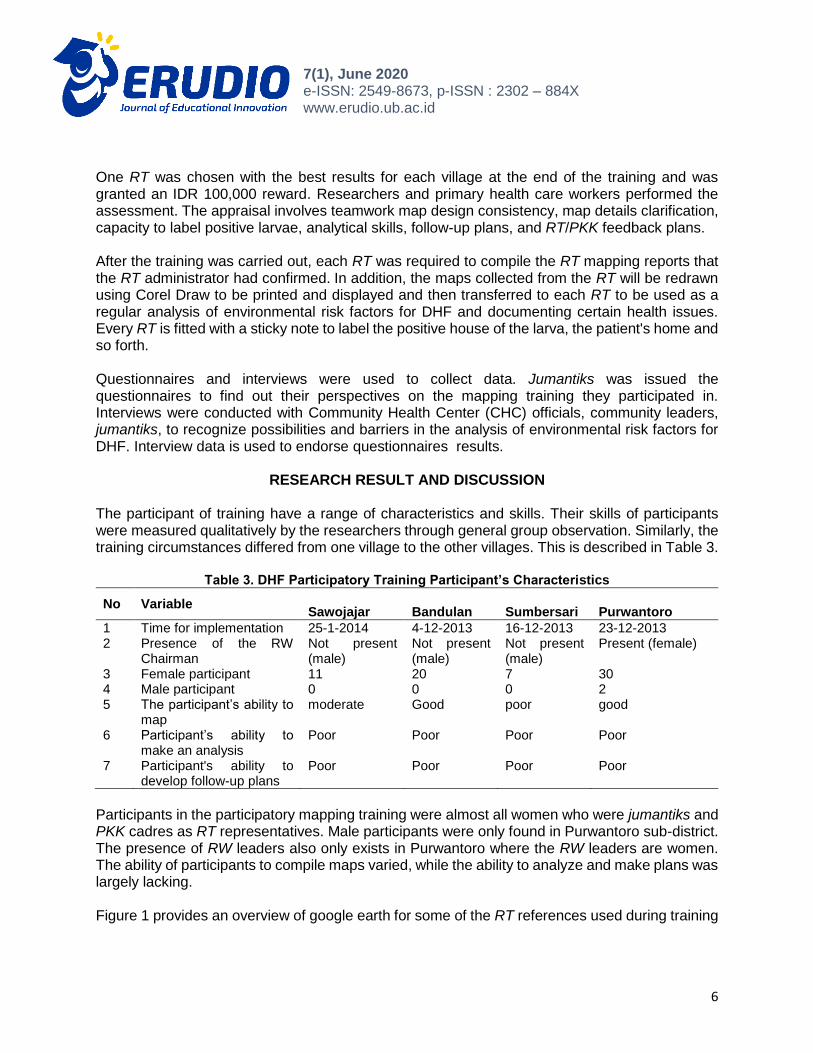
One RT was chosen with the best results for each village at the end of the training and was granted an IDR 100,000 reward. Researchers and primary health care workers performed the assessment. The appraisal involves teamwork map design consistency, map details clarification, capacity to label positive larvae, analytical skills, follow-up plans, and RT/PKK feedback plans. After the training was carried out, each RT was required to compile the RT mapping reports that the RT administrator had confirmed. In addition, the maps collected from the RT will be redrawn using Corel Draw to be printed and displayed and then transferred to each RT to be used as a regular analysis of environmental risk factors for DHF and documenting certain health issues. Every RT is fitted with a sticky note to label the positive house of the larva, the patient's home and so forth. Questionnaires and interviews were used to collect data. Jumantiks was issued the questionnaires to find out their perspectives on the mapping training they participated in. Interviews were conducted with Community Health Center (CHC) officials, community leaders, jumantiks, to recognize possibilities and barriers in the analysis of environmental risk factors for DHF. Interview data is used to endorse questionnaires results.
RESEARCH RESULT AND DISCUSSION The participant of training have a range of characteristics and skills. Their skills of participants were measured qualitatively by the researchers through general group observation. Similarly, the training circumstances differed from one village to the other villages. This is described in Table 3.
Table 3. DHF Participatory Training Participant’s Characteristics
No Variable
Sawojajar Bandulan Sumbersari Purwantoro
1 Time for implementation 25-1-2014 4-12-2013 16-12-2013 23-12-2013 2 Presence of the RW
Chairman Not present (male)
Not present (male)
Not present (male)
Present (female)
3 Female participant 11 20 7 30 4 Male participant 0 0 0 2 5 The participant’s ability to
map moderate Good poor good
6 Participant’s ability to make an analysis
Poor Poor Poor Poor
7 Participant's ability to develop follow-up plans
Poor Poor Poor Poor
Participants in the participatory mapping training were almost all women who were jumantiks and PKK cadres as RT representatives. Male participants were only found in Purwantoro sub-district. The presence of RW leaders also only exists in Purwantoro where the RW leaders are women. The ability of participants to compile maps varied, while the ability to analyze and make plans was largely lacking. Figure 1 provides an overview of google earth for some of the RT references used during training

7(1), June 2020 e-ISSN: 2549-8673, p-ISSN : 2302 – 884X www.erudio.ub.ac.id
7
Figure 1. Google Earth Print Results at RW level. a. Bandulan Village, b. Sawojajar Village, c.
Sumbersari Village, d. Purwantoro Village
In addition participants were asked to map their respective Google Earth RTs on oil paper. The results can be seen in the Figure 2.

7(1), June 2020 e-ISSN: 2549-8673, p-ISSN : 2302 – 884X www.erudio.ub.ac.id
8
Figure 2. Mapping by jumantiks of DHF and its risk factors at the RT level. (From RT's best) a.
Bandulan, RT 7, b. Sawojajar RT 6, c. Sumbersari, d. RT 1 Purwantoro RT 4
The results of the participant's analysis of the conditions surrounding the larva positive house, for example whether adjacent to other larva positive house, vacant land, vacant house, or public facilities based on the map that has been made can be seen in Table 4. The participant's answers are summarized as follows.

7(1), June 2020 e-ISSN: 2549-8673, p-ISSN : 2302 – 884X www.erudio.ub.ac.id
9
Table 4. Participant's interpretations of DHF's causes
Participant's Interpretations
Near vacant lot / yard
Larvae positive housing in close proximity
Not close to other larval positive houses / vacant land / public facilities
The larva positive house is usually damp, hard to dry as crowded communities lack sunlight
The participants were then asked to draw up an intervention program for DHF prevention in their respective RT from the research undertaken by the participants. The details can be viewed in the Table 5 below.
Table 5. Plan Of Activities According To The Ideas Of The Participant
Proposed Participant Activity Program
Public waterway / gutter washing facility / own households
Provide information
Using ovitrap
Waste sorting
Tree planting on vacant land
Larvae survey
DHF patient’s survey
Community service (river washing, sanitation, buildings, rooms)/Mosquito Nest eradication (Pemberantasan Sarang Nyamuk / PSN) every Friday.
Giving Information (PKK meeting, From one house to another)
Ovitrap
Fogging
Using abate
This demonstrates in the table above that the participants taken different suggestions varying from behavioral changes to chemical methods. It is expected that participants will be able to share it with RT / PKK RT administrators or other executives after engaging in the training Forums that can be used to discuss activity strategies are mostly group gatherings, leaders, PKK, RT PKK, yasinan, male gathering. Some participants expect all residents to conduct PSN every Friday, give information about each RT gathering, and provide an abate.

7(1), June 2020 e-ISSN: 2549-8673, p-ISSN : 2302 – 884X www.erudio.ub.ac.id
10
Figure 3. Redrawing (with Corel Draw) DHF mapping by jumantiks at the RT level and its risk factors. (Out of the best RT) a. Bandulan of RT 7, b. RT 6 of Sawojajar, c. RT 1 Sumbersari, d.
Purwantoro of RT 4
In the mapping training, jumantiks were also asked to analyze problems related to DHF and plan for prevention activities. However, these activities have not been followed up on by their respective PKK RTs although some of the participants are the PKK RT Heads. Planning is still restricted to fulfilling the tasks in the training.

7(1), June 2020 e-ISSN: 2549-8673, p-ISSN : 2302 – 884X www.erudio.ub.ac.id
11
Manual mapping requires the skills to visualize maps and cadres' understanding of the situation in their area. Generally the Kampung area is the collection of unstructured buildings. In addition, the high displacement of residents' housing status often makes it difficult for cadres to create a map of the homes of people. This is different from residential areas where the arrangement of houses is more structured and tidy. The more structured and tidy the arrangement of the houses, the easier for cadres to draw them. This mapping training is still using manual methods in drawing maps and different incident points. The reason is that there were no cadres at that time (2013) who used smartphones for contact or other uses. Use Geographic Information System (GIS) technologies or internet technology, given the increasing number of people using the internet, it is necessary to develop a mapping from this mapping training experience. Geographic Information System (GIS) is a method for developing understanding of data through visualization and analysis, currently the system using GIS is widely developed and used by public health officials in planning, monitoring and for surveillance purposes. Displaying data with maps in the same data can provide more detail than tables so that patterns and associations between them can be evaluated more easily. Nevertheless, when it takes place in developing countries, GIS has its own problems. One of the challenges faced include expensive and complicated GIS tools, frequently low quality data available, and low capacity data analysis to allow misinterpretation (Fisher & Myers, 2011). The map approach used in this training is very simplistic as opposed to GIS, where the jumantiks are asked to draw themselves and provide details where the good field is flicked to inquire for analysis of the data. In this training, only Google Earth-based text, markers and maps are needed and do not include gadget or special software that are not typically used by jumantiks. Questionnaires given to all participants showed that some participants approved during the training to use the tool, including google earth charts, colour markers and transparent paper. It is meant to be achieved in a sustainable way using basic tools. After the training finished, however, the implementation of mapping yielded unsatisfactory results. Several drawbacks based on the expectations of the participants include high mobility of the population so that participants find mapping difficult to do. Another alternative that is relatively inexpensive, in line with the industrial revolution 4.0, is the use of internet technology for website and android based applications. With this application program, the location and time in real time and real place will be able to be obtained. It will also be easier to obtain data visualization. Nevertheless, training may still be required first to be used by jumantiks. After the training ended, participants were asked for their opinions on the implementation of the DHF mapping training (Table 6).

7(1), June 2020 e-ISSN: 2549-8673, p-ISSN : 2302 – 884X www.erudio.ub.ac.id
12
Table 6. Percentage Of Jumantiks Who Said ' Agreed ' And ' Strongly Agreed ' On The Statement
regarding DHF Mapping Training
No Statement (n=46) %
1 Google maps make RT maps simple to draw 89,6
2 Color markers help to show RT maps 93,2
3 Transparent paper allows to construct the detailed map of RT 89,6
Note : The percentages define "accepted-strongly agreed"
Most of the participants felt that the methods and equipment provided to compile maps were felt to be helpful in mapping activities. The ease of technology to be used is relevant to one component in the theory of innovation diffusion, namely complexity. Other components that support this training are the testing and observation (Oldenburg and Glanz, 2008). This training model can be tried independently by cadres. The results of the mapping can be seen visually by the cadres. But the benefits will only be obtained when the mapping is done routinely and there are follow-up efforts to prevent mosquito breeding. This is a challenge for the development of the DHF risk factor mapping training model. In general, jumantiks activities related to the use of DHF mapping results after the training ended apparently still lacking even though there is a CHC that is very supportive. Even having commissioned cadres to do the mapping before, but this also did not work well. The presence of our team seems to foster more enthusiasm of CHC officers to carry out the mapping again. The enthusiasm of health workers can simultaneously be a support for the sustainability of this training. The commitment of CHC to maintain mapping sustainability cannot be ignored in mapping DHF risk factors. The activities carried out more by the jumantiks are looking for information about the conditions that cause DHF in their area and looking for homes that have the potential as breeding grounds for mosquitoes. This is shown in Table 7.
Table 7. Percentage of respondents who conducted DHF mapping training activities
No Activity After The Completion Of The Research (n=41) %
1 Search for homes / buildings at high risk of positive larvae 40.3 2 Looking for information on other factors in my region that could trigger DHF 42.1 3 Create a dengue preventive program based on the results of the training 26.1 4 Use of a training outcome map for other RT uses 20.8 5 Teach other cadres to map 37.4
Participant’s perceptions which are the result of mapping practice show the trainees' lack of awareness regarding the need to recognize mosquito breeding sites and the habit of mosquito biting and resting. This lack of perception can be corrected by providing additional training to jumantiks and raising awareness of the importance of surveillance as a control of dengue cases.

7(1), June 2020 e-ISSN: 2549-8673, p-ISSN : 2302 – 884X www.erudio.ub.ac.id
13
Through regular and intensive meetings it is hoped that this awareness will increase (Fertman & Allensworth, 2010). To achieve the stages of political power and psychological power will depend on external factors, namely the condition of the community around the residence of the cadre, and the internal factors of the cadre itself. In rural communities, perhaps cadres are a group of people who are more knowledgeable and more skilled than the general population. This might be different from the situation in urban areas. When mapping is a need for CHC to implement it, potential for the implementation of DHF risk factor analysis may improve. Mapping activities need to involve jumantiks in preparing maps of their respective regions because it is cadres who understand the situation of their respective regions. The results of the mapping can be used as material for periodic discussion and can be a reference in determining the focus of the target activity. Regarding the intervention given by the researchers, the answers from the CHC officers varied from not knowing to having tried to follow up on the DHF mapping training, as follows:
"Do not know. Mrs. E didn't tell me. I should have held it at the time, but I was not told. "(CHC 2 officer, interview).
"As for our follow-up, we will continue to train cadres to remain active in reporting every case and the implementation of PJB, cadres who conduct larvae checks" (CHC Officer 2, interview).
One of the CHC wanted their work location to become a model for later mapping of health problems.
"From the first I always wanted mothers to make maps. But the map never appears. I am also confused ... For RW 6 we will make a pilot roject "(CHC 1 Officer, interview)
Sustainability was seen when one of the CHC had tried to assign cadres in their area to compile a map of certain health problems after the research ended. However, because cadres did not memorize the houses of each citizen, although cadres had participated in similar training, cadres experienced difficulties.
"Yesterday, the mapping model directly reported to all cadres of the five CHC areas. At that time I also asked to make a map for each region, but it also turned out to have difficulty mapping itself. Some gather together some don't ”(CHC 1 officer, interview)
It seems that one CHC had tried to reach the stage of function (at the desired level) in order to maintain the desired benefits as stated by Stirman et al (2012). However, this effort has not been successful. On the other hand, the results show contrasting sustainability outcomes after the end of the training, based at qualitative data from CHC officers. This indicates that there are still minimal resources to continue monitoring, there is still insufficient access to data by health community centers officers, and there is a need to strengthen the interrelationship between cadres and health community centers personnel. The presence of an officer who said he wanted to make a RW as a pilot project in his Village showed that this training method still had the potential to be applied even though it was still necessary to consider the duration of the training, the trainee's

7(1), June 2020 e-ISSN: 2549-8673, p-ISSN : 2302 – 884X www.erudio.ub.ac.id
14
characteristics, and the development of sufficient capability so that the jumantiks could work independently. There are still limitations in this experimental field research, including lack of duration and lack of intense cadres-researchers meetings. This is because jumantiks have a high level of activity both as jumantiks and as housewives or workers, making it difficult to share time for analysts. Ideally this research is carried out with participatory design. The research was conducted in one day of training covering all activities ranging from building trust, providing material, making maps, analyzing data and making follow-up plans whose hopes were conveyed to influential community leaders in the area. The short training period time results in the lack of fulfillment of the ability of the trainees. The ability of participants assessed from this study included the ability to compile maps, make analyzes, and make follow-up plans. The capability of participants to compile maps is not similar, 2 villages have good capabilities, and the rest have moderate and poor capabilities. Their skill variance requires a different approach in order to satisfy the final results obtained. In villages with less capability, it need an easy instructors' guidance and direction to apply and need to repeat lectures with the same subject matter (Driedger et al., 2007) . On the other hand, the villages with the capability to make good maps but other skills are still lacking, can be given more training or practice for problem analysis and follow-up planning. Participatory design research involves taking information and data from each participant, including the level of experience, ability, access to data, data requirements and steps that affect the final outcome of the training. Ideally, the participatory training model will be held in more than one meeting, where the first meeting will be held to build trust between the stakeholders expected to run the program, the second and third meetings will have the same material with shorter time, and subsequent meetings can discuss input or action plans further based on participant perceptions or analysis of data that has been presented at the previous meeting, and to complete this participatory method, a meeting is needed between jumantiks and health community officers as data analyzer (Driedger et al., 2007). Environmental risk factor mapping may be part of the mosquito vector surveillance activities to control environmental risk factors for DHF. The effectiveness of Aedes aegypti mosquito vector surveillance can be accomplished through the delivery of information regarding often unrealized mosquito breeding containers in wells or water storage areas, for example. It is a rather difficult to introduce mosquito breeding sites due to the ability of female mosquitoes to adapt to the environment. Female mosquitoes can suck blood and rest, and if they find an appropriate breeding spot, they can lay eggs. The controls of early detection of outbreak, control through surveillance, and control in endemic areas are an effective way to prevent dengue transmission so that challenges in technical problems can be resolved (Eisen & Lozano-fuentes, 2009).
CONCLUSION
There was still a variation of participant's abilities to assemble maps in addition to the ability of cadres to analyze and plan for the most part. Jumantiks cadres and a small number of CHC, though there are still many challenges, have attempted to do the mapping individually. The

7(1), June 2020 e-ISSN: 2549-8673, p-ISSN : 2302 – 884X www.erudio.ub.ac.id
15
mapping and training model has the potential to be further improved by taking into account the participant's attributes, strategies and skills as well as the CHC's interest in their sustainability. Suggestion In line with the current system technologies, the use of internet technology for website and android-based applications needs to be considered.
REFERENCES Driedger, S. M., Kothari, A., Morrison, J., Sawada, M., Crighton, E. J., & Graham, I. D. (2007).
Correction : Using participatory design to develop ( public ) health decision support systems through GIS. BioMed Central, 53(6), 1–12. https://doi.org/10.1186/1476-072X-6-53
Eisen, L., & Lozano-fuentes, S. (2009). Use of Mapping and Spatial and Space-Time Modeling Approaches in Operational Control of Aedes aegypti and Dengue. PLoS NEGLECTED TROPICAL DISEASES, 3(4), 1–7. https://doi.org/10.1371/journal.pntd.0000411
Fertman, C. I., & Allensworth, D. D. (2010). HEALTH PROMOTION PROGRAMS FROM THEORY TO PRACTICE. (T. S. F. P. H. Education, Ed.). San Fransisco: Jossey - Bass A Wiley Imprint.
Fisher, R. P., & Myers, B. A. (2011). Free and simple GIS as appropriate for health mapping in a low resource setting : a case study in eastern Indonesia. International Journal of Health Geographics, 10(1), 15. https://doi.org/10.1186/1476-072X-10-15
Friedman, J. (1992). Empowerment: The politics of alternative development . Cambridge, MA: Blackwell.Glanz, K., Rimer, B. K., & Viswanath, K. (2008). HEALTH BEHAVIOR AND HEALTH EDUCATION. (C. T. Orleans, Ed.) (4th ed.). San Fransisco: Jossey - Bass A Wiley Imprint.
Lloyd-Smith, J. O., Schreiber, S. J., Kopp, P. E., & Getz, W. M. (2005). Superspreading and the effect of individual variation on disease emergence. Nature, 438(November), 355–359. https://doi.org/10.1038/nature04153
Provinsi Jawa Timur, D. K. (2017). PROVINSI JAWA TIMUR. Surabaya. Retrieved from https://dinkes.jatimprov.go.id/userfile/dokumen/PROFIL KESEHATAN JATIM 2016.pdf
P2PL Dinkes Kota Malang. 2008. Laporan DBD P2PL Dinkes Kota Malang. 2009. Laporan DBD P2PL Dinkes Kota Malang. 2011. Laporan DBD P2PL Dinkes Kota Malang. 2013. Laporan DBD Rogers E.M. (1995) Diffusion of Innovations: Modifications of a Model for
Telecommunications. In: Stoetzer MW., Mahler A. (eds) Die Diffusion von Innovationen in der Telekommunikation. Schriftenreihe des Wissenschaftlichen Instituts für Kommunikationsdienste, vol 17. Springer, Berlin, Heidelberg
Sanchez, L., Perez, D., Cruz, G., Castro, M., Kouri, G., Shkedy, Z., … Stuyft, P. Van Der. (2009). Intersectoral coordination , community empowerment and dengue prevention : six years of controlled interventions in Playa. Tropical Medicine and International Health, 14(11), 1356–1364. https://doi.org/10.1111/j.1365-3156.2009.02379.x
Spiegel, J., Bennett, S., Hattersley, L., Hayden, M. H., Kittayapong, P., Gubler, D., … Zielinski-gutie, E. (2005). Barriers and Bridges to Prevention and Control of Dengue : The Need for a Social – Ecological Approach. EcoHealth, 2, 273–290. https://doi.org/10.1007/s10393-
7(1), June 2020 e-ISSN: 2549-8673, p-ISSN : 2302 – 884X www.erudio.ub.ac.id
16
005-8388-x Stirman, S. W., Kimberly, J., Cook, N., Calloway, A., Castro, F., & Charns, M. (2012). The
sustainability of new programs and innovations : a review of the empirical literature and recommendations for future research. Implementation Science, 7(17), 1–19.
Vanlerberghe, V., Toledo, M., Rodrı´guez, M., Gomez, D., Baly, A., Benitez, J. R., & Van der Stuyft, P. (2009). Community involvement in dengue vector control : cluster randomised trial. BMJ, 338, 1–7. https://doi.org/10.1136/bmj.b1959
WHO. (2009). Dengue Guidelines For Diagnosis, Treatment, Prevention and Control - New Edition. Geneva: WHO Press.
Wiweko, A. (2013). Geographic Information System(GIS) for Dengue Research in Indonesia: A Review. Tropical Medicine Journal, 3(2), 121–127.