the parking lot onto the lake. tracksetting ends at the
TRANSCRIPT
© B
anff
Lake
Lou
ise T
ouris
m /
Paul
Zizk
a
© B
anff
Lak
e Lo
uise
Tou
rism
/Pau
l Ziz
ka
Winter Trails in theLake Louise area
Deer Lynx WolfHare
Deer LynxElkHareLynxElk WolfHare
Deer LynxElk Wolf
Deer Elk WolfHare
© Banff Lake Louise Tourism
© C. Douce
Bow Summit
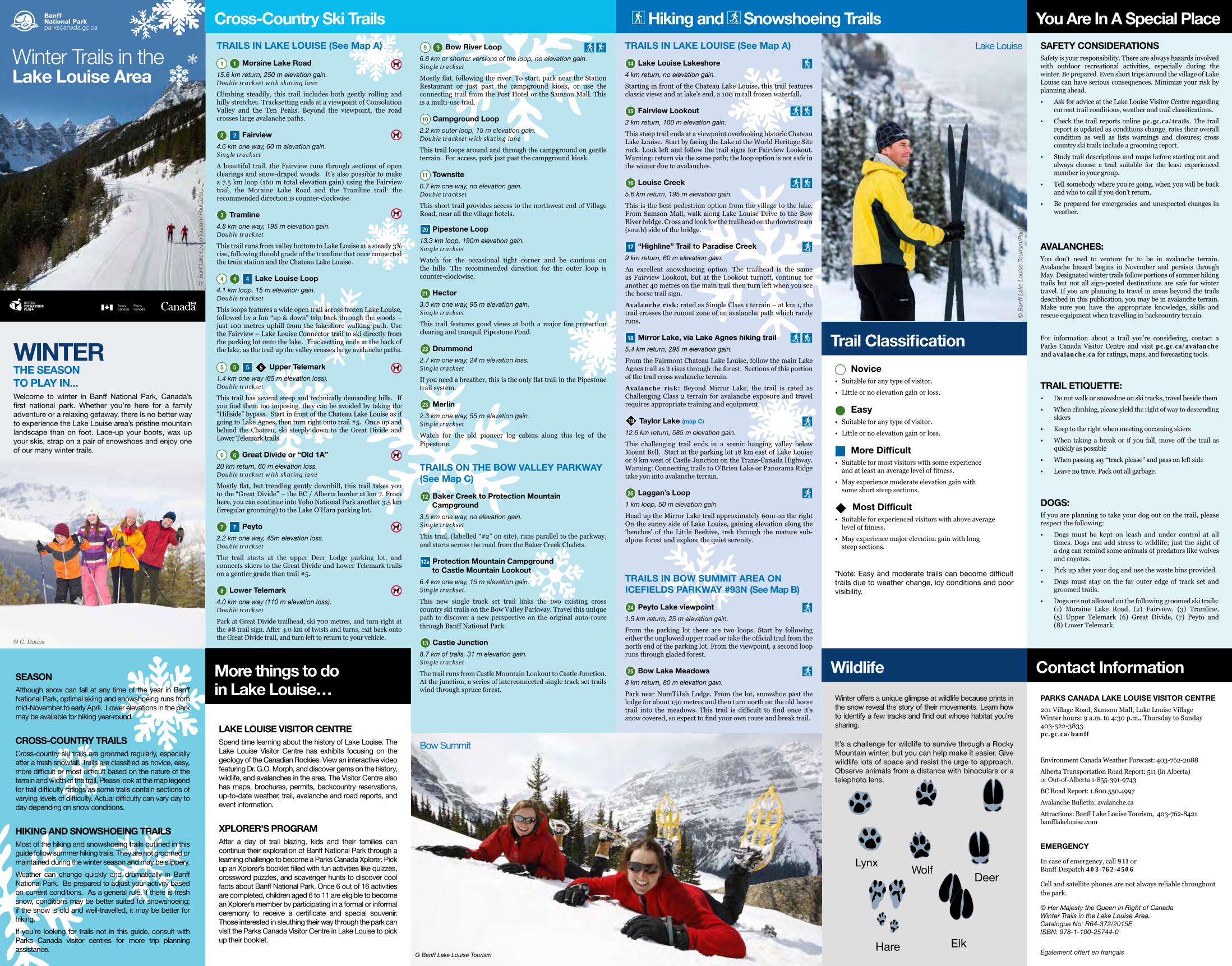
Lake Louise
winTeR THe season To PLay in...Welcome to winter in Banff National Park, Canada’sfirst national park. Whether you’re here for a familyadventure or a relaxing getaway, there is no better wayto experience the Lake Louise area’s pristine mountainlandscape than on foot. Lace-up your boots, wax upyour skis, strap on a pair of snowshoes and enjoy oneof our many winter trails.
seasonAlthough snow can fall at any time of the year in Banff National Park, optimal skiing and snowshoeing runs from mid-November to early April. Lower elevations in the park may be available for hiking year-round.
CRoss-CounTRy TRaiLsCross-country ski trails are groomed regularly, especially after a fresh snowfall. Trails are classified as novice, easy, more difficult or most difficult based on the nature of the terrain and width of the trail. Please look at the map legend for trail difficulty ratings as some trails contain sections of varying levels of difficulty. Actual difficulty can vary day to day depending on snow conditions.
HikinG anD snowsHoeinG TRaiLsMost of the hiking and snowshoeing trails outlined in this guide follow summer hiking trails. They are not groomed or maintained during the winter season and may be slippery.
Weather can change quickly and dramatically in Banff National Park. Be prepared to adjust your activity based on current conditions. As a general rule, if there is fresh snow, conditions may be better suited for snowshoeing; if the snow is old and well-travelled, it may be better for hiking.
If you’re looking for trails not in this guide, consult with Parks Canada visitor centres for more trip planning assistance.
More things to do in Lake Louise…More things to do in Lake Louise…
Lake Louise VisiToR CenTRe Spend time learning about the history of Lake Louise. The Lake Louise Visitor Centre has exhibits focusing on the geology of the Canadian Rockies. View an interactive video featuring Dr. G.O. Morph, and discover gems on the history, wildlife, and avalanches in the area. The Visitor Centre also has maps, brochures, permits, backcountry reservations, up-to-date weather, trail, avalanche and road reports, and event information.
XPLoReR’s PRoGRaM After a day of trail blazing, kids and their families can continue their exploration of Banff National Park through a learning challenge to become a Parks Canada Xplorer. Pick up an Xplorer’s booklet filled with fun activities like quizzes, crossword puzzles, and scavenger hunts to discover cool facts about Banff National Park. Once 6 out of 16 activities are completed, children aged 6 to 11 are eligible to become an Xplorer’s member by participating in a formal or informal ceremony to receive a certificate and special souvenir. Those interested in sleuthing their way through the park can visit the Parks Canada Visitor Centre in Lake Louise to pick up their booklet.
Cross-Country ski Trails
TRaiLs in Lake Louise (see Map a)
1 1 Moraine Lake Road
15.6 km return, 250 m elevation gain.Double trackset with skating lane
Climbing steadily, this trail includes both gently rolling and hilly stretches. Tracksetting ends at a viewpoint of Consolation Valley and the Ten Peaks. Beyond the viewpoint, the road crosses large avalanche paths.
2 2 Fairview
4.6 km one way, 60 m elevation gain.Single trackset
A beautiful trail, the Fairview runs through sections of open clearings and snow-draped woods. It’s also possible to make a 7.5 km loop (160 m total elevation gain) using the Fairview trail, the Moraine Lake Road and the Tramline trail: the recommended direction is counter-clockwise.
3 Tramline
4.8 km one way, 195 m elevation gain. Double trackset
This trail runs from valley bottom to Lake Louise at a steady 3% rise, following the old grade of the tramline that once connected the train station and the Chateau Lake Louise.
4 4 4 Lake Louise Loop
4.1 km loop, 15 m elevation gain. Double trackset
This loops features a wide open trail across frozen Lake Louise, followed by a fun “up & down” trip back through the woods – just 100 metres uphill from the lakeshore walking path. Use the Fairview – Lake Louise Connector trail to ski directly from the parking lot onto the lake. Tracksetting ends at the back of the lake, as the trail up the valley crosses large avalanche paths.
5 5 5 5 upper Telemark
1.4 km one way (65 m elevation loss). Double trackset
This trail has several steep and technically demanding hills. If you find them too imposing, they can be avoided by taking the “Hillside” bypass. Start in front of the Chateau Lake Louise as if going to Lake Agnes, then turn right onto trail #5. Once up and behind the Chateau, ski steeply down to the Great Divide and Lower Telemark trails.
6 6 Great Divide or “old 1a”
20 km return, 60 m elevation loss. Double trackset with skating lane
Mostly flat, but trending gently downhill, this trail takes you to the “Great Divide” – the BC / Alberta border at km 7. From here, you can continue into Yoho National Park another 3.5 km (irregular grooming) to the Lake O’Hara parking lot.
7 7 Peyto
2.2 km one way, 45m elevation loss.Double trackset
The trail starts at the upper Deer Lodge parking lot, and connects skiers to the Great Divide and Lower Telemark trails on a gentler grade than trail #5.
8 Lower Telemark
4.0 km one way (110 m elevation loss).Double trackset
Park at Great Divide trailhead, ski 700 metres, and turn right at the #8 trail sign. After 4.0 km of twists and turns, exit back onto the Great Divide trail, and turn left to return to your vehicle.
9 9 Bow River Loop
6.6 km or shorter versions of the loop, no elevation gain. Single trackset
Mostly flat, following the river. To start, park near the Station Restaurant or just past the campground kiosk, or use the connecting trail from the Post Hotel or the Samson Mall. This is a multi-use trail.
10 Campground Loop
2.2 km outer loop, 15 m elevation gain. Double trackset with skating lane
This trail loops around and through the campground on gentle terrain. For access, park just past the campground kiosk.
11 Townsite
0.7 km one way, no elevation gain.Double trackset
This short trail provides access to the northwest end of Village Road, near all the village hotels.
20 Pipestone Loop
13.3 km loop, 190m elevation gain.Single trackset
Watch for the occasional tight corner and be cautious on the hills. The recommended direction for the outer loop is counter-clockwise.
21 Hector
3.0 km one way, 95 m elevation gain.Single trackset
This trail features good views at both a major fire protection clearing and tranquil Pipestone Pond.
22 Drummond
2.7 km one way, 24 m elevation loss.Single trackset
If you need a breather, this is the only flat trail in the Pipestone trail system.
23 Merlin
2.3 km one way, 55 m elevation gain.Single trackset
Watch for the old pioneer log cabins along this leg of the Pipestone.
TRaiLs on THe Bow VaLLey PaRkway (see Map C)
12 Baker Creek to Protection Mountain Campground
3.5 km one way, no elevation gain.Single trackset
This trail, (labelled “#2” on site), runs parallel to the parkway, and starts across the road from the Baker Creek Chalets.
12a Protection Mountain Campground to Castle Mountain Lookout
6.4 km one way, 15 m elevation gain.Single trackset.
This new single track set trail links the two existing cross country ski trails on the Bow Valley Parkway. Travel this unique path to discover a new perspective on the original auto-route through Banff National Park.
13 Castle Junction
8.7 km of trails, 31 m elevation gain. Single trackset
The trail runs from Castle Mountain Lookout to Castle Junction. At the junction, a series of interconnected single track set trails wind through spruce forest.
Hiking and snowshoeing Trails
TRaiLs in Lake Louise (see Map a)
14 Lake Louise Lakeshore
4 km return, no elevation gain.
Starting in front of the Chateau Lake Louise, this trail features classic views and at lake’s end, a 100 m tall frozen waterfall.
15 Fairview Lookout
2 km return, 100 m elevation gain.
This steep trail ends at a viewpoint overlooking historic Chateau Lake Louise. Start by facing the Lake at the World Heritage Site rock. Look left and follow the trail signs for Fairview Lookout. Warning: return via the same path; the loop option is not safe in the winter due to avalanches.
16 Louise Creek
5.6 km return, 195 m elevation gain.
This is the best pedestrian option from the village to the lake. From Samson Mall, walk along Lake Louise Drive to the Bow River bridge. Cross and look for the trailhead on the downstream (south) side of the bridge.
17 “Highline” Trail to Paradise Creek
9 km return, 60 m elevation gain.
An excellent snowshoeing option. The trailhead is the same as Fairview Lookout, but at the Lookout turnoff, continue for another 40 metres on the main trail then turn left when you see the horse trail sign.
Avalanche risk: rated as Simple Class 1 terrain – at km 1, the trail crosses the runout zone of an avalanche path which rarely runs.
18 Mirror Lake, via Lake agnes hiking trail
5.4 km return, 295 m elevation gain.
From the Fairmont Chateau Lake Louise, follow the main Lake Agnes trail as it rises through the forest. Sections of this portion of the trail cross avalanche terrain.
Avalanche risk: Beyond Mirror Lake, the trail is rated as Challenging Class 2 terrain for avalanche exposure and travel requires appropriate training and equipment.
19 Taylor Lake (map C)
12.6 km return, 585 m elevation gain.
This challenging trail ends in a scenic hanging valley below Mount Bell. Start at the parking lot 18 km east of Lake Louise or 8 km west of Castle Junction on the Trans-Canada Highway. Warning: Connecting trails to O’Brien Lake or Panorama Ridge take you into avalanche terrain.
26 Laggan’s Loop
1 km loop, 50 m elevation gain
Head up the Mirror Lake trail approximately 60m on the right On the sunny side of Lake Louise, gaining elevation along the ‘benches’ of the Little Beehive, trek through the mature sub-alpine forest and explore the quiet serenity.
TRaiLs in Bow suMMiT aRea on iCeFieLDs PaRkway #93n (see Map B)
24 Peyto Lake viewpoint
1.5 km return, 25 m elevation gain.
From the parking lot there are two loops. Start by following either the unplowed upper road or take the official trail from the north end of the parking lot. From the viewpoint, a second loop runs through gladed forest.
25 Bow Lake Meadows
8 km return, 80 m elevation gain.
Park near NumTiJah Lodge. From the lot, snowshoe past the lodge for about 150 metres and then turn north on the old horse trail into the meadows. This trail is difficult to find once it’s snow covered, so expect to find your own route and break trail.
Trail Classification
novice• Suitable for any type of visitor.
• Little or no elevation gain or loss.
easy• Suitable for any type of visitor.
• Little or no elevation gain or loss.
More Difficult• Suitable for most visitors with some experience
and at least an average level of fitness.
• May experience moderate elevation gain with some short steep sections.
Most Difficult• Suitable for experienced visitors with above average
level of fitness.
• May experience major elevation gain with long steep sections.
*Note: Easy and moderate trails can become difficult trails due to weather change, icy conditions and poor visibility.
wildlife
Winter offers a unique glimpse at wildlife because prints in the snow reveal the story of their movements. Learn how to identify a few tracks and find out whose habitat you’re sharing.
It’s a challenge for wildlife to survive through a Rocky Mountain winter, but you can help make it easier. Give wildlife lots of space and resist the urge to approach. Observe animals from a distance with binoculars or a telephoto lens.
LynxWolf
eer
Hare Elk
D
you are in a special Place
saFeTy ConsiDeRaTionsSafety is your responsibility. There are always hazards involved with outdoor recreational activities, especially during the winter. Be prepared. Even short trips around the village of Lake Louise can have serious consequences. Minimize your risk by planning ahead.
• Ask for advice at the Lake Louise Visitor Centre regarding current trail conditions, weather and trail classifications.
• Check the trail reports online pc.gc.ca/trails. The trail report is updated as conditions change, rates their overall condition as well as lists warnings and closures; cross country ski trails include a grooming report.
• Study trail descriptions and maps before starting out and always choose a trail suitable for the least experienced member in your group.
• Tell somebody where you’re going, when you will be back and who to call if you don’t return.
• Be prepared for emergencies and unexpected changes in weather.
aVaLanCHes:You don’t need to venture far to be in avalanche terrain. Avalanche hazard begins in November and persists through May. Designated winter trails follow portions of summer hiking trails but not all sign-posted destinations are safe for winter travel. If you are planning to travel in areas beyond the trails described in this publication, you may be in avalanche terrain. Make sure you have the appropriate knowledge, skills and rescue equipment when travelling in backcountry terrain.
For information about a trail you’re considering, contact a Parks Canada Visitor Centre and visit pc.gc.ca/avalanche and avalanche.ca for ratings, maps, and forecasting tools.
TRaiL eTiqueTTe: • Do not walk or snowshoe on ski tracks, travel beside them
• When climbing, please yield the right of way to descending skiers
• Keep to the right when meeting oncoming skiers
• When taking a break or if you fall, move off the trail as quickly as possible
• When passing say “track please” and pass on left side
• Leave no trace. Pack out all garbage.
DoGs:If you are planning to take your dog out on the trail, please respect the following:
• Dogs must be kept on leash and under control at all times. Dogs can add stress to wildlife; just the sight of a dog can remind some animals of predators like wolves and coyotes.
• Pick up after your dog and use the waste bins provided.
• Dogs must stay on the far outer edge of track set and groomed trails.
• Dogs are not allowed on the following groomed ski trails: (1) Moraine Lake Road, (2) Fairview, (3) Tramline, (5) Upper Telemark (6) Great Divide, (7) Peyto and (8) Lower Telemark.
Contact information
PaRks CanaDa Lake Louise VisiToR CenTRe
201 Village Road, Samson Mall, Lake Louise Village Winter hours: 9 a.m. to 4:30 p.m., Thursday to Sunday 403-522-3833 pc.gc.ca/banff
Environment Canada Weather Forecast: 403-762-2088
Alberta Transportation Road Report: 511 (in Alberta) or Out-of-Alberta 1-855-391-9743
BC Road Report: 1.800.550.4997
Avalanche Bulletin: avalanche.ca
Attractions: Banff Lake Louise Tourism, 403-762-8421 banfflakelouise.com
eMeRGenCy
In case of emergency, call 911 or Banff Dispatch 403-762-4506
Cell and satellite phones are not always reliable throughout the park.
© Her Majesty the Queen in Right of Canada Winter Trails in the Lake Louise Area. Catalogue No: R64-372/2015E ISBN: 978-1-100-25744-0
Également offert en français

Mount Niblock2976 m9764‘
Mount Whyte2983 m9787´
Devil’s Thumb2458 m8065´
Little Beehive2225 m7300´
Sheol Mountain2776 m9108´
Haddo Peak3070 m10073´
Mount Aberdeen3152 m10342´
Saddle Mountain2433 m7983´
Fairview Mountain2744 m9003´
Mount St. Piran2649 m8691‘
Big Beehive2270 m7448´
LAKE LOUISESKI AREA
Fish Creek to Skoki Backcountry
VILLAGEOF LAKELOUISE
VILLAGEOF LAKELOUISE
ChateauLake Louise
ChateauLake Louise
5
Banff
Banff
Jasper
Field
GR
EA
T
D
IV
ID
E
ALB
ERTA
BR
ITISH
CO
LUM
BIA
0
0 1
2Kilometres
Miles
Lake O'Hara Parking Lot
LAKE LOUISE
BOW
RIVERRiver
LouiseCreek
Pipes
tone
ParadiseCreek
Lake Agnes
MirrorLake
MudLake
Herbert Lake
Pipestone Pond
Bath
Creek
1A
1A
93
93
Add hiking trail dots from the Warden Station symbol near the end of Sheol Road to connect with the pedestrian overpass over the Trans-Canada Highway (shows that you can walk or ski from village over the highway using the pedestrian overpass and connects to Pipestone Trail.
20
20
20
20
207
4
2
17
18
5
6
6
5
7
8
8
8
6
2
44
15
14
23
22
22
21
21
3
16
16
3
3
1
1
10
10 9
9
9
11
9
9
Save paper and share this guide with others.
BOW LAKE
PEYTO
LAK
E
Observation Peak3174 m10414´
Jasper
Lake Louise
MountJimmy Simpson
2966 m9730´
Mount Thompson3084 m10119´
24
25
93
93
0
10
2KilometresMiles
5
7
7
4 14
4
152
3
16
6
8
5
4
7
LAKELOUISE
ChateauLake
Louise
DeerLodge
26
26
Baker Creek Chalets
Lake Louise
Radium Hot Springs
0 5Kilometres
Miles0 3
RockboundLake
TowerLake
Castle Mountain2766 m9076’
CastleJunction
Castle MountainLookout
BOW
RIVER1A
13
SmithLake
TaylorLake
1A
93
19 Banff
12
12a
Cross-Country ski Trails
TRaiLs in Lake Louise
1 1 Moraine Lake Road (map a)
15.6 km return, 250 m elevation gain. Double trackset withskating lane.
2 2 Fairview (map a)
4.6 km one way, 60 m elevation gain. Single trackset.
3 Tramline (map a)
4.8 km one way, 195 m elevation gain. Double trackset.
4 4 4 Lake Louise Loop (map a)
4.1 km loop, 15 m elevation gain. Double trackset.
5 5 5 5 upper Telemark (map a)
1.4 km one way, 65 m elevation loss. Double trackset.
6 6 Great Divide or “old 1a” (map a)
20 km return, 60 m elevation loss. Double trackset with skating lane.
7 7 Peyto (map a)
2.2 km one way, 45 m elevation loss. Double trackset.
8 Lower Telemark (map a)
4.0 km one way, 110 m elevation loss. Double trackset.
9 9 Bow River Loop (map a)
6.6 km or shorter versions of the loop, no elevation gain. Single trackset.
10 Campground Loop (map a)
2.2 km outer loop, 15 m elevation gain. Double trackset with skating lane.
11 Townsite (map a)
0.7 km one way, no elevation gain. Double trackset.
20 Pipestone Loop (map a)
13.3 km loop, 190 m elevation gain. Single trackset.
21 Hector (map a)
3.0 km one way, 95 m elevation gain. Single trackset.
22 Drummond (map a)
2.7 km one way, 24 m elevation loss. Single trackset.
23 Merlin (map a)
2.3 km one way, 55 m elevation gain. Single trackset.
TRaiLs on THe Bow VaLLey PaRkway
12 Baker Creek to Protection Mountain Campground (map C)
3.5 km one way, no elevation gain. Single trackset.
12a Protection Mountain Campground to Castle Mountain Lookout (map C)
6.4 km one way, 15 m elevation gain. Single trackset.
13 Castle Junction (map C)
8.7 km of trails, 31 m elevation gain. Single trackset.
Hiking and snowshoeing Trails
TRaiLs neaR Lake Louise
14 Lake Louise Lakeshore (map a)
4 km return, no elevation gain.
15 Fairview Lookout (map a)
2 km return, 100 m elevation gain.
16 Louise Creek (map a)
5.6 km return, 195 m elevation gain.
17 “Highline” Trail to Paradise Creek (map a)
9 km return, 60 m elevation gain.
18 Mirror Lake, via Lake agnes hiking trail
(map a) 5.4 km return, 295 m elevation gain.
19 Taylor Lake (map C)
12.6 km return, 585 m elevation gain.
26 Laggan’s Loop (small inset)
1 km loop, 50 m elevation gain.
TRaiLs in Bow suMMiT aRea on iCeFieLDs PaRkway #93n
24 Peyto Lake viewpoint (map B)
1.5 km return, 25 m elevation gain.
25 Bow Lake Meadows (map B)
8 km return, 80 m elevation gain.
Legend
ski Trails
novice
novice Track & skating
easy
easy Track & skating
More Difficult
Most Difficult
Hiking/snowshoe Trails
Parks Canada Visitor Centre
warden office
Viewpoint
Pedestrian overpass
Downhill ski area
RV Campground
Parking
washroom/Privy
no Dogs
MAP AVILLAGE OF
LAKE LOUISE
MAP BBOW LAKE
AREA
CHATEAUAREA 5
MAP CBOW VALLEY AREA
Share the trails
Partageons les sentiers