the northern pacific railway bridge at...
TRANSCRIPT
The Northern Pacific Railway Bridge at Bismarck by Edward C. Murphy
In 1864 President Abraham Lincoln signed into law a bill granting forty alternate sections of public land per mile in the Dakota, Montana, Idaho, and Washington Territories and twenty alternate sections per mile in Minnesota and Oregon along the northern route of the transcontinental railway as a means of supporting its construction. A few years later, the Northern Pacific Railway Company purchased the charter, and provisions were made that allowed the land holdings along the route of the railroad to be extended up to fifty miles in the territories and thirty miles in the states. 1 The Northern Pacific Railway Company began laying track eastward from Kalama, Washington, in March 1871 and westward from near Duluth, Minnesota, in July 1871. The eastern segment of track reached Bismarck (then a small village named Edwinton) in June 1873.2
The financial panic of 1873 caused economic depression across the country. The panic was brought about by many factors, the chief one being the large investment that business houses in both the United States and Europe had made in railroads which showed no promise of immediate returns. Many businesses declared bankruptcy, including the Northern Pacific, which halted construction of the eastern segment at Bismarck with 1,500 miles remaining to be completed. It would be six years before construction would begin again in earnest west of Bismarck.3 During that hiatus, the Northern Pacific reorganized and began a renewed campaign to advertise the West as a means of increasing passenger and freight travel and stimulating sales of their land holdings to raise capital to pay for the resumed construction of the transcontinental railway.4
From its beginning, the Northern Pacific suffered a shortage of capital to finance the $85 to $120 million estimated cost to complete construction of the northern route. 5 Congress had mandated both a starting and a completion date for construction on the line, neither of which would be met by the Northern Pacific. After the Northern Pacific missed the July 4, 1879, completion date, they operated under the constant threat that their charter might be revoked by Congress. Proponents of the Northern Pacific and proponents of the Union
2
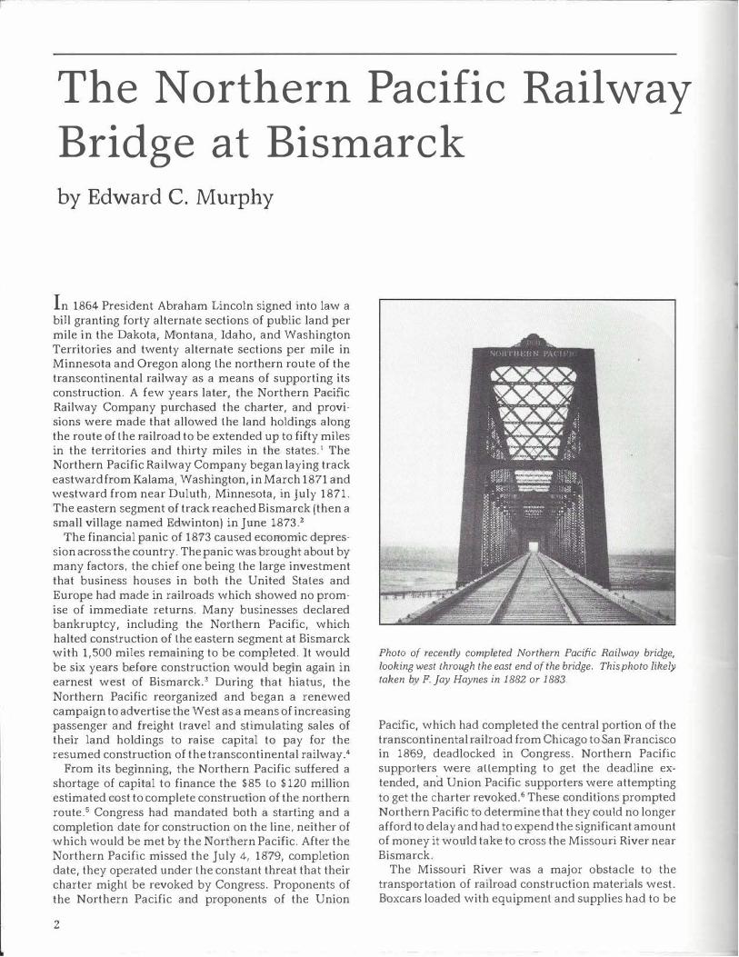
Photo of recently completed Northern Pacific Railway bridge, looking west through the east end of the bridge. This photo likely taken by F. Jay Haynes in 1882 or 1883.
Pacific, which had completed the central portion of the transcontinental railroad from Chicago to San Francisco in 1869, deadlocked in Congress. Northern Pacific supporters were attempting to get the deadline extended, and Union Pacific supporters were attempting to get the charter revoked.6 These conditions prompted Northern Pacific to determine that they could no longer afford to delay and had to expend the significant amount of money it would take to cross the Missouri River near Bismarck.
The Missouri River was a major obstacle to the transportation of railroad construction materials west. Boxcars loaded with equipment and supplies had to be
0
Union Pacific Railroad
.,,,.--....-� .......
¼ -
North Platte ,........._
------= :-: ---, t.::.;....-..l-----
.,, -... ---�---_-.;.._;;__ _ ____ ---l.._
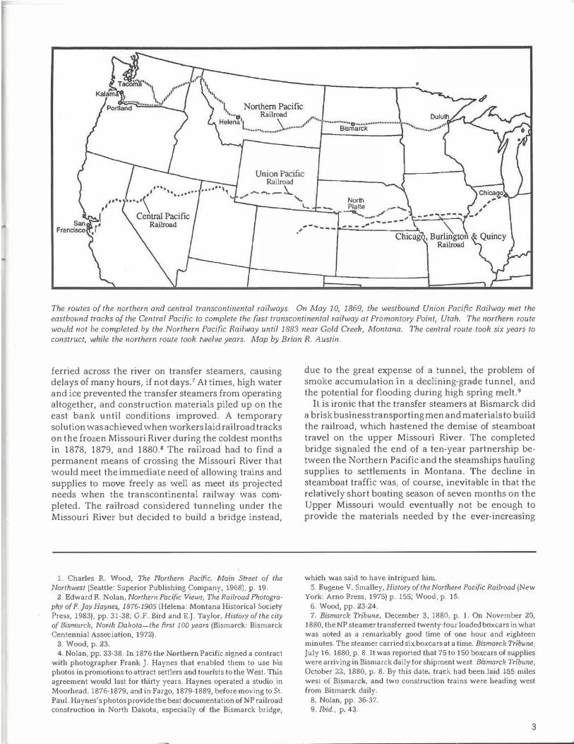
The routes of the northern and central transcontinental railways. On May 10, 1869, the westbound Union Pacific Railway met the eastbound tracks of the Central Pacific to complete the first transcontinental railway at Promontory Point, Utah. The northern route would not be completed by the Northern Pacific Railway until 1883 near Gold Creek, Montana. The central route took six years to construct, while the northern route took twelve years. Map by Brian R. Austin.
ferried across the river on transfer steamers, causing delays of many hours, if not days. 7 At times, high water and ice prevented the transfer steamers from operating altogether, and construction materials piled up on the east bank until conditions improved. A temporary solution was achieved when workers laid railroad tracks on the frozen Missouri River during the coldest months in 1878, 1879, and 1880.8 The railroad had to find a permanent means of crossing the Missouri River that would meet the immediate need of allowing trains and supplies to move freely as well as meet its projected needs when the transcontinental railway was completed. The railroad considered tunneling under the Missouri River but decided to build a bridge instead,
1. Charles R. Wood, The Northern Pacific, Main Street of the Northwest (Seattle: Superior Publishing Company, 1968), p. 19.
2. Edward R. Nolan, Northern Pacific Views, The Railroad Photography of F. Jay Haynes, 1876-1905 (Helena: Montana Historical Society Press, 1983), pp. 31-38; G.F. Bird and E.J. Taylor, History of the city of Bismarck, North Dakota-the first 100 years (Bismarck: Bismarck Centennial Association, 1972).
3. Wood, p. 23. 4. Nolan, pp. 33-38. In 1876 the Northern Pacific signed a contract
with photographer Frank J. Haynes that enabled them to use !us photos in promotions to attract settlers and tourists to the West. This agreement would last for thirty years. Haynes operated a studio in Moorhead, 1876-1879, and in Fargo, 1879-1889, before moving to St. Paul. Haynes's photos provide the best documentation of NP railroad construction in North Dakota, especially of the Bismarck bridge,
due to the great expense of a tunnel, the problem of smoke accumulation in a declining-grade tunnel, and the potential for flooding during high spring melt.9
Il is ironic that the transfer steamers at Bismarck did a brisk business transporting men and materials to build the railroad, which hastened the demise of steamboat travel on the upper Missouri River. The completed bridge signaled the end of a ten-year partnership between the Northern Pacific and the steamships hauling supplies to settlements in Montana. The decline in steamboat traffic was, of course, inevitable in that the relatively short boating season of seven months on the Upper Missouri would eventually not be enough to provide the materials needed by the ever-increasing
which was said to have intrigued hin1. 5. Eugene V. Smalley, History of the Northern Pacific Railroad {New
York: Arno Press, 1975) p. 155; Wood, p. 15. 6. Wood, pp. 23-24. 7. Bismarck Tribune, December 3, 1880, p. 1. On November 20,
1880, the NP steamer transferred twenty-four loaded boxcars in what was noted as a remarkably good time of one hour and eighteen minutes. The steamer carried six boxcars at a time. Bismarck Tribune, July 16, 1880, p. 8. It was reported that 75 to 150 boxcars of supplies were arriving in Bismarck daily for shipment west. Bismarck Tribune, October 22, 1880, p. 8. By this date, track had been laid 155 miles west of Bismarck, and two construction trains were heading west from Bismarck daily.
8. Nolan, pp. 36-37. 9. Ibid., p. 43.
3
,J.: \
. .. �-
,.
,.,
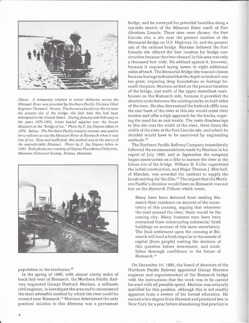
Above: A temporary solution to winter deliveries across the Missouri River was provided by Northern Pacific Division Chief Engineer Thomas L. Rosser. Tracks were placed over the ice near the present site of the bridge-the first time this had been attempted in the United States. During January and February in the years 1879-1881, trains hauled supplies over the frozen Missouri on the "bridge of ice.• Photo by F . Jay Haynes taken in 1879. Below: The Northern Pacific transfer steamer was used to ferry railcars across the Missouri River at Bismarck when it was free of ice. Slow and inefficient, this method was at the mercy of the unpredictable Missouri. Photo by F. Jay Haynes tahen in 1880. Both photos are courtesy of Haynes Foundation Collection, Montana Historical Society, Helena, Montana.
population in the territories. 10
In the spring of 1880, with almost ninety miles of track laid west of Bismarck, the Northern Pacific Railway requested George Shattuck Morison, a selfmade civil engineer, to investigate the area and to recommend the most advisable method by which the river could be crossed near Bismarck. 11 Morison determined the only practical solution to this dilemma was a permanent
4
bridge, and he surveyed for potential localities along a ten-mile stretch of the Missouri River north of Fort Abraham Lincoln. Three sites were chosen: the Fort Lincoln site, a site near the present location of the Memorial Bridge on U.S. Highway 10, and the present site of the railroad bridge. Morison believed the Fort Lincoln site offered the best location for bridge construction because the river channel in this area was only a thousand feet wide. He advised against it, however, because it required laying seven to eight additional miles of track. The Memorial B_ridge site was not chosen because borings indicated that the depth to bedrock was too great, requiring deep foundations or footings beneath the piers. Morison settled on the present location of the bridge, just north of the upper steamboat warehouses on the Bismarck side, because it provided the shortest route between the existing tracks on both sides of the river. He also determined the bedrock cliffs near the east bank of the river at this site would resist river erosion and offer a high approach for the tracks, negating the need for an east trestle. The main disadvantage to this site was the width of the river, three times the width of the river at the Fort Lincoln site, and which he decided would have to be narrowed by engineering methods. 12
The Northern Pacific Railway Company immediately followed the recommendations made by Morison in his report of July 1880, and in September the company began construction on a dike to narrow the river at the future site of the bridge. William H. Fuller supervised the initial construction, and Major Thomas J. Mitchell, of Mandan, was awarded the contract to supply the brush matting for the dike. 13 The impact that the Northern Pacific's decision would have on Bismarck was not lost on the Bismarck Tribune which wrote,
Many have been deterred from making Bismarck their residence on account of the uncertainty of this crossing, arguing that wherever the road crossed the river, there would be the coming city. Many business men have been restrained from constructing substantial brick buildings on account of this same uncertainty. The final settlement upon the crossing at Bismarck will lend a fresh impulse to thousands of capital [from people] waiting the decision of this question before investment, and estab· lishes thorough confidence in the future of Bismarck. 14
On December 16, 1880, the board of directors of the Northern Pacific Railway appointed George Morison engineer and superintendent of the Bismarck bridge with the instructions that the work was to be carried forward with all possible speed. Morison was uniquely qualified for this position, although this is not readily apparent from a review of his formal education. He earned a law degree from Harvard and practiced law in New York for a year before abandoning that practice in
1867 and entering the field of civil engineering, a profession for which he had no formal education. His initial training came during construction of a large bridge over the Missouri River at Kansas City. He so impressed the chief engineer of that project, Octave Chanute, that Chanute appointed Morison his principal assistant when he became chief engineer for the Erie Railroad. Both of these endeavors provided him with valuable experience in railroad bridge design that he put to use in later projects. In 1875 Morison organized the bridge contracting firm of Morison, Field, and Company of New York. In 1880 he withdrew from the firm and devoted his time to consulting. Morison lived in New York, except for the period 1887-1898 when he lived in Chicago.
The Missouri River was regarded by many as the most treacherous river in the country to bridge and the Northern Pacific showed great confidence in Morison when they chose him to design and supervise the building of the first bridge to span the upper Missouri River. Following completion of the Bismarck bridge, Morison designed and supervised the building of a number of great railroad bridges in rapid succession over the Missouri River at Sioux City, Blair, Omaha, Rulo, Nebraska City, Atchison, and Leavenworth, and over the Mississippi River at Winona, Burlington, Alton, St. Louis, and Memphis, as well as numerous other bridges across the country. Morison sat on a number of boards and commissions, including the Isthmian Canal Commission from 1899 to 1901, and his powerful argument for the Panama route, backed by a detailed study, was a determining factor in the decision on the location of the Panama Canal. Morison was held in high regard by his peers as demonstrated by his selection to give the presidential address at the annual meeting of the American Society of Civil Engineers in 1895. At the time of his death on July 1 , 19031 at the age of sixty-one, Morison was regarded by many to be the leading bridge engineer in America, if not the entire world. 15
The Northern Pacific awarded contracts for the construction of the bridge during the early months of 1881. There were few firms in Dakota Territory or the surrounding area that had workers trained in the required skills of major construction, so most of the contracts went to eastern firms. The proposals for both the piers and the bridge spans were opened in New York. Nor them Pacific officials awarded the contract for the pier
10. Wood, pp. 37-38. Bismarck 1i-ibune, November 19, 1880, p. 1. The boating season on the upper Missouri River in 1880 began on April 15 and ended on November 16, during which time 35 million pounds of freight was transported. Lewis F. Crawford, Histo1y of North Dakota (Chicago: The American Historical Society, 1931), pp. 208-209. By 1887 the extension of the railroad into Helena, Montana, had practically put an end to steamboating on the upper Missouri River. By 1931 only one boat was running between Bismarck and Fort Benton.
11. George S. Morison, Bismarck Bridge, a report to A. Anderson
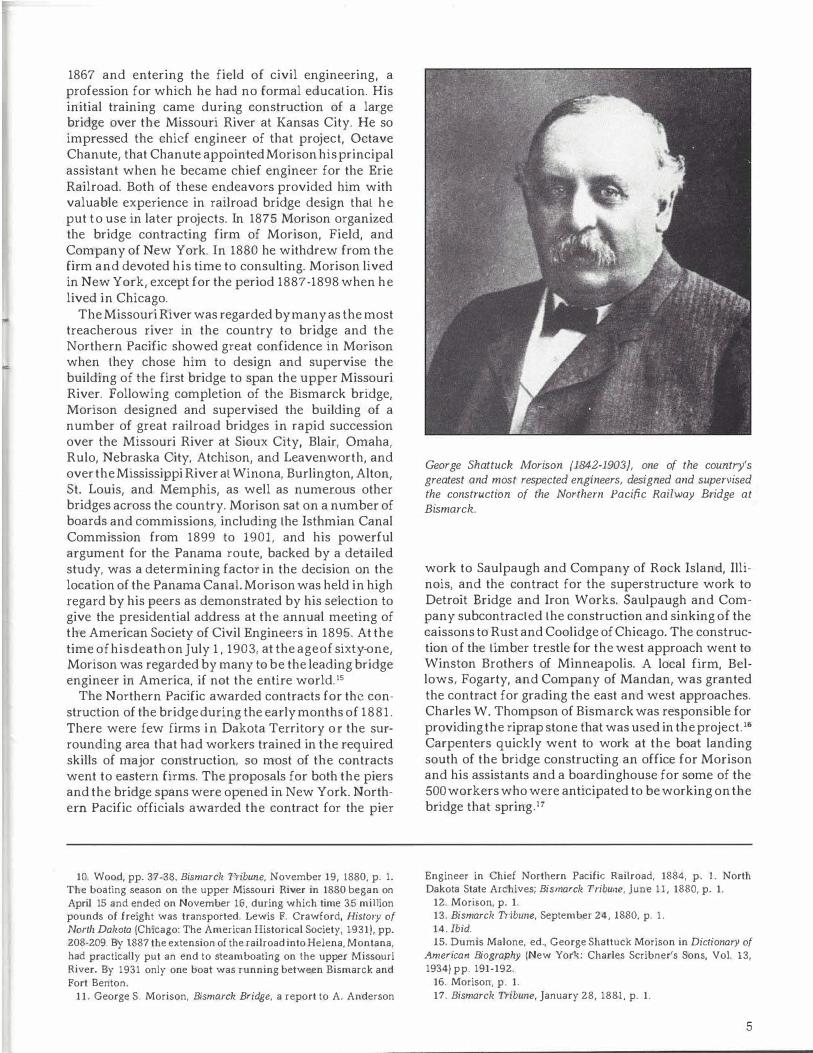
George Shattuck Morison (1842-1903), one of the country's greatest and most respected engineers, designed and supervised the construction of the Northern Pacific Railway Bridge at Bismarck.
work to Saulpaugh and Company of Rock Island, Illinois, and the contract for the superstructure work to Detroit Bridge and Iron Works. Saulpaugh and Company subcontracted the construction and sinking of the caissons to Rust and Coolidge of Chicago. The construction of the timber trestle for the west approach went to Winston Brothers of Minneapolis. A local firm, Bellows, Fogarty, and Company of Mandan, was granted the contract for grading the east and west approaches. Charles W. Thompson of Bismarck was responsible for providing the riprap stone that was used in the project. 16
Carpenters quickly went to work at the boat landing south of the bridge constructing an office for Morison and his assistants and a boardinghouse for some of the 500 workers who were anticipated to be working on the bridge that spring_li
Engineer in Chief Northern Pacific Railroad, 1884, p. l. North Dakota State Archives; Bismarck Tribune, June 11, 1880, p. 1.
12. Morison, p. 1. 13. Bismarck Tribune, September 24, 1880, p. 1. 14. Ibid. 15. Dumis Malone, ed., George Shattuck Morison in Dictionary of
American Biography (New York: Charles Scribner's Sons, Vol. 13, 1934) pp. 191-192.
16. Morison, p. 1. 17. Bismarck Tribune, January 28, 1881, p. 1.
5
The Dike
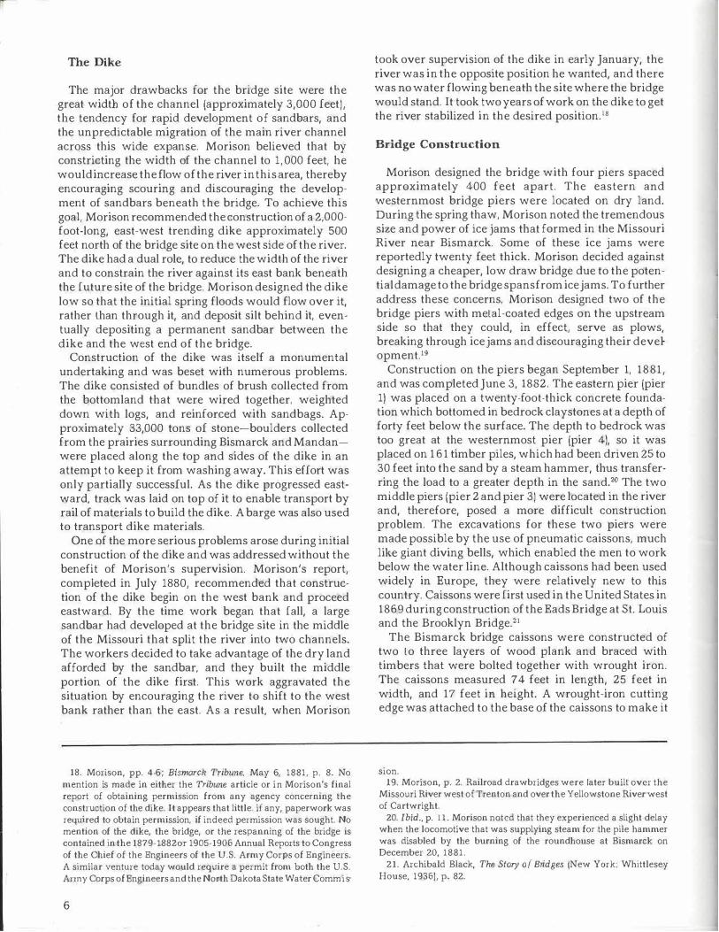
The major drawbacks for the bridge site were the great width of the channel (approximately 3,000 feet), the tendency for rapid development of sandbars, and the unpredictable migration of the main river channel across this wide expanse. Morison believed that by constricting the width of the channel to 1,000 feet, he would increase the flow of the river in this area, thereby encouraging scouring and discouraging the development of sandbars beneath the bridge. To achieve this goal, Morison recommended the construction of a 2,000-foot-long, east-west trending dike approximately 500 feet north of the bridge site on the west side of the river. The dike had a dual role, to reduce the width of the river and to constrain the river against its east bank beneath the future site of the bridge. Morison designed the dike low so that the initial spring floods would flow over it, rather than through it, and deposit silt behind it, eventually depositing a permanent sandbar between the dike and the west end of the bridge.
Construction of the dike was itself a monumental undertaking and was beset with numerous problems. The dike consisted of bundles of brush collected from the bottomland that were wired together, weighted down with logs, and reinforced with sandbags. Approximately 33,000 tons of stone-boulders collected from the prairies surrounding Bismarck and Mandanwere placed along the top and sides of the dike in an attempt to keep it from washing away. This effort was only partially successful. As the dike progressed eastward, track was laid on top of it to enable transport by rail of materials to build the dike. A barge was also used to transport dike materials.
One of the more serious problems arose during initial construction of the dike and was addressed without the benefit of Morison's supervision. Morison's report, completed in July 1880, recommended that construction of the dike begin on the west bank and proceed eastward. By the time work began that fall, a large sandbar had developed at the bridge site in the middle of the Missouri that split the river into two channels. The workers decided to take advantage of the dry land afforded by the sandbar, and they built the middle portion of the dike first. This work aggravated the situation by encouraging the river to shift to the west bank rather than the east. As a result, when Morison
18. Morison, pp. 4-6; Bismarck Tribune, May 6, 1881, p. 8. No mention is made in either the Tribune article or in Morison's final report of obtaining permission from any agency concerning the construction of the dike. It appears that little, if any, paperwork was requfred to obtain permission, if indeed permission was sought. No mention of the dike, the bridge, or the respanning of the bridge is contained in the 1879-1882or 1905-1906 Annual Reports to Congress of the Chief of the Engineers of the U.S. Army Corps of Engineers. A similar venture today would require a permit from both the U.S. Anny Corps of Engineers and the North Dakota State Water Com mis-
6
took over supervision of the dike in early January, the river was in the opposite position he wanted, and there was no water flowing beneath the site where the bridge would stand. It took two years of work on the dike to get the river stabilized in the desired position. 18
Bridge Construction
Morison designed the bridge with four piers spaced approximately 400 feet apart. The eastern and westernmost bridge piers were located on dry land. During the spring thaw, Morison noted the tremendous size and power of ice jams that formed in the Missouri River near Bismarck. Some of these ice jams were reportedly twenty feet thick. Morison decided against designing a cheaper, low draw bridge due to the potential damage to the bridge spans from ice jams. To further address these concerns, Morison designed two of the bridge piers with metal-coated edges on the upstream side so that they could, in effect, serve as plows, breaking through ice jams and discouraging their development.19
Construction on the piers began September 1, 1881, and was completed June 3, 1882. The eastern pier (pier 1) was placed on a twenty-foot-thick concrete foundation which bottomed in bedrock claystones at a depth of forty feet below the surface. The depth to bedrock was too great at the westernmost pier (pier 4), so it was placed on 161 timber piles, which had been driven 25 to 30 feet into the sand by a steam hammer, thus transferring the load to a greater depth in the sand.20 The two middle piers (pier 2 and pier 3) were located in the river and, therefore, posed a more difficult construction problem. The excavations for these two piers were made possible by the use of pneumatic caissons, much like giant diving bells, which enabled the men to work below the water line. Although caissons had been used widely in Europe, they were relatively new to this country. Caissons were first used in the United States in 1869 during construction of the Eads Bridge at St. Louis and the Brooklyn Bridge.z1
The Bismarck bridge caissons were constructed of two to three layers of wood plank and braced with timbers that were bolted together with wrought iron. The caissons measured 74 feet in length, 25 feet in width, and 17 feet in height. A wrought-iron cutting edge was attached to the base of the caissons to make it
sion. 19. Morison, p. 2. Railroad drawbridges were later built over the
Missouri River west of Trenton and over the Yellowstone River west of Cartwright.
20. Ibid., p. 11. Morison noted that they experienced a slight delay when the locomotive that was supplying steam for the pile hammer was disabled by the burning of the roundhouse at Bismarck on December 20, 1881.
21. Archibald Black, The Story of Bridges jNew York: Whittlesey House, 1936), p. 82.
!ID -ALLUVIUM 11111 -BEDROCK
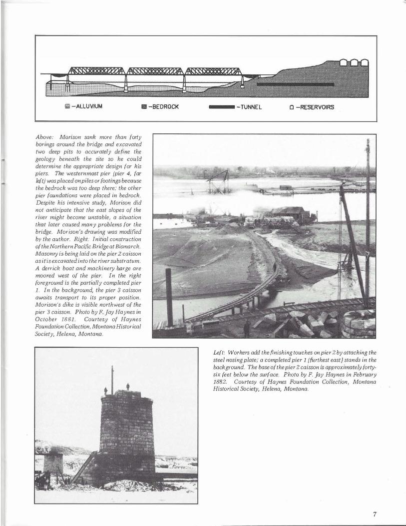
Above: Morison sank more than forty borings around the bridge and excavated two deep pits to accurately define the geology beneath the site so he could determine the appropriate design for his piers. The westernmost pier {pier 4, far left) was placed on piles or footings because the bedrock was too deep there; the other pier foundations were placed in bedrock. Despite his intensive study, Morison did not anticipate that the east slopes of the river might become unstable, a situation that later caused many problems for the bridge. Morison's drawing was modified by the author. Right: Initial construction of the Northern Pacific Bridge at Bismarck. Masonry is being laid on the pier 2 caisson as it is excavated into the river substratum. A derrick boat and machinery barge are moored west of the pier. In the right foreground is the partially completed pier 1. In the background, the pier 3 caisson awaits transport to its proper position. Morison's dike is visible northwest of the pier 3 caisson. Photo by F . Jay Haynes in October 1881. Courtesy of Haynes Foundation Collection, Montana Historical Society, Helena, Montana.
-TUNNEL 0 -RESERVOIRS
Left: Workers add the finishing touches on pier 2 by attaching the steel nosing plate; a completed pier 1 {furthest east) stands in the background. The base of the pier 2 caisson is approximately fortysix feet below the surface. Photo by F. Jay Haynes in February 1882. Courtesy of Haynes Foundation Collection, Montana Historical Society, Helena, Montana.
7
I •• • / ... ,,7,tullina( >:t,r,nlu,,.
JJ<J,..,,,,.,,,,, ., Su·he� .fh*l.f!J p,-.,,-,,q 'f <1W,l°67 lfM NHN • .,,
� .:O,.lf(llt.:ft;\' P1ll'll'lr- R;-1//:N .... - .,...,. . '"' .. " . . • . ... rv .. ,,,IJ
IJISMARCI< Bl?ID£:t:.
c- .-.�H,r.,_ . s,-.-, ,_,..,,.t ,. ';{ ,,',.J., .• •Acn1,l..,. .. .-•
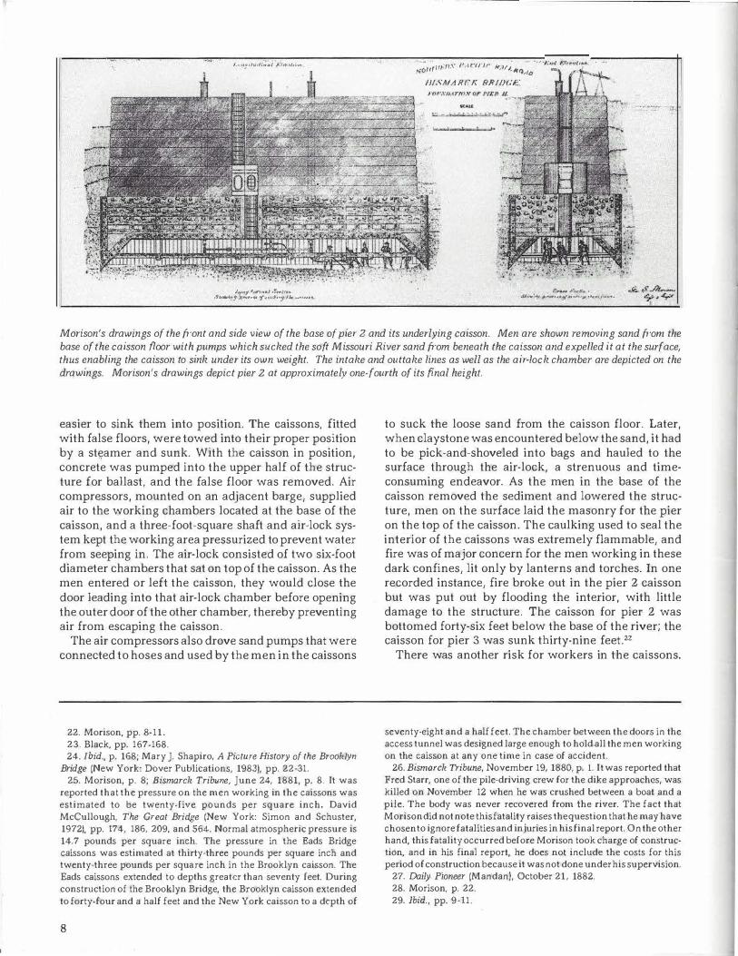
Morison's drawings of the front and side view of the base of pier 2 and its underlying caisson. Men are shown removing sand from the base of the caisson floor with pumps which sucked the soft Missouri River sand from beneath the caisson and expelled it at the surface, thus enabling the caisson to sink under its own weight. The intake and outtake lines as well as the air-lock chamber are depicted on the drawings. Morison's drawings depict pier 2 at approximately one-fourth of its fi_nal height.
easier to sink them into position. The caissons, fitted with false floors, were towed into their proper position by a steamer and sunk. With the caisson in position, concrete was pumped into the upper half of the structure for ballast, and the false floor was removed. Air compressors, mounted on an adjacent barge, supplied air to the working chambers located at the base of the caisson, and a three-foot-square shaft and air-lock system kept the working area pressurized to prevent water from seeping in. The air-lock consisted of two six-foot diameter chambers that sat on top of the caisson. As the men entered or left the caisson, they would close the door leading into that air-lock chamber before opening the outer door of the other chamber, thereby preventing air from escaping the caisson.
The air compressors also drove sand pumps that were connected to hoses and used by the men in the caissons
22. Morison, pp. 8· 11.
23. Black, pp. 167-168.
24. Ibid., p. 168; Mary J. Shapiro, A Picture History of the Brooklyn Bridge (New York: Dover Publications, 1983), pp. 22-31.
25. Morison, p. 8; Bismarck Tribune, June 24, 1881, p. 8. It was reported that the pressure on the men working in the caissons was estimated to be twenty-five pounds per square inch. David McCullough, The Great Bridge (New York: Simon and Schuster, 19721, pp. 174, 186, 209, and 564. Normal atmospheric pressure is 14.7 pounds per square inch. The pressure in the Eads Bridge caissons was estimated at thirty-three pounds per square inch and twenty-three pounds per squa.re inch in the Brooklyn caisson. The Eads caissons extended to depths greater than seventy feet. During construction of the Brooklyn Bridge, the Brooklyn caisson extended to forty-four and a half feet and the New York caisson to a depth of
8
to suck the loose sand from the caisson floor. Later, when claystone was encountered below the sand, it had to be pick-and-shoveled into bags and hauled to the surface through the air-lock, a strenuous and timeconsuming endeavor. As the men in the base of the caisson removed the sediment and lowered the structure, men on the surface laid the masonry for the pier on the top of the caisson. The caulking used to seal the interior of the caissons was extremely flammable, and fire was of major concern for the men working in these dark confines, lit only by lanterns and torches. In one recorded instance, fire broke out in the pier 2 caisson but was put out by flooding the interior, with little damage to the structure. The caisson for pier 2 was bottomed forty-six feet below the base of the river; the caisson for pier 3 was sunk thirty-nine feet.22
There was another risk for workers in the caissons.
seventy-eight and a half feet. The chamber between the doors in the access tunnel was designed large enough to hold all the men working on the caisson at any one time in case of accident.
26. Bismarck Tribune, November 19, 1880, p. 1. It was reported that Fred Starr, one of the pile-driving crew for the dike approaches, was killed on November 12 when he was crushed between a boat and a pile. The body was never recovered from the river. The fact that Morison did not note this fatality raises the question that he may have chosen to ignore fatalities and injuries in his final report. On the other hand, this fatality occurred before Morison took charge of construction, and in his final report, he does not include the costs for this period of construction because it was not done under his supervision.
27. Daily Pioneer (Mandan}, October 21, 1882.
28. Morison, p. 22.
29. Ibid., pp. 9-11.
Sudden movement from an area of compressed air into an area under atmospheric conditions results in the formation of nitrogen gas bubbles in the bloodstream which adversely affects muscles or joints and can be fatal. This decompression sickness was alternately called "caisson disease" or "the bends" because of its effects on the worker's limbs. Doctors often did not immediately diagnose this disease because the symptoms did not generally occur until sometime after the worker left the pressurized environment.23 As a result, a number of workers died or suffered permanent injuries from caisson disease while constructing both the Eads and Brooklyn Bridges.24
Despite the fact that workers in the Bismarck caissons toiled fifty to sixty feet below the surface of the Missouri River, Morison makes no mention of illness due to caisson disease. This does not necessarily mean there was none. He does note in his report that the weight of the caissons and masonry were often not enough to sink the caisson into the underlying substratum without relieving the air pressure inside the working chamber. To remedy this situation, the air pressure was decreased until the caisson settled approximately two feet and then was increased again. This process reportedly lasted about five minutes and, to save time, was performed while the men remained inside the working chamber.25
If any fatalities or injuries occurred during the construction of the Bismarck bridge, they were not noted in Morison's final report.26
The laying of masonry on a sinking caisson provided a special problem to the masons who could not follow their normal routine of leveling the stones to keep the pier straight. As a result, the workers had to devise special methods to insure the stones were level.27 The granite slabs or stones are approximately twenty-eight inches thick. The specifications for the piers required every third face-stone-that is, a stone which has an
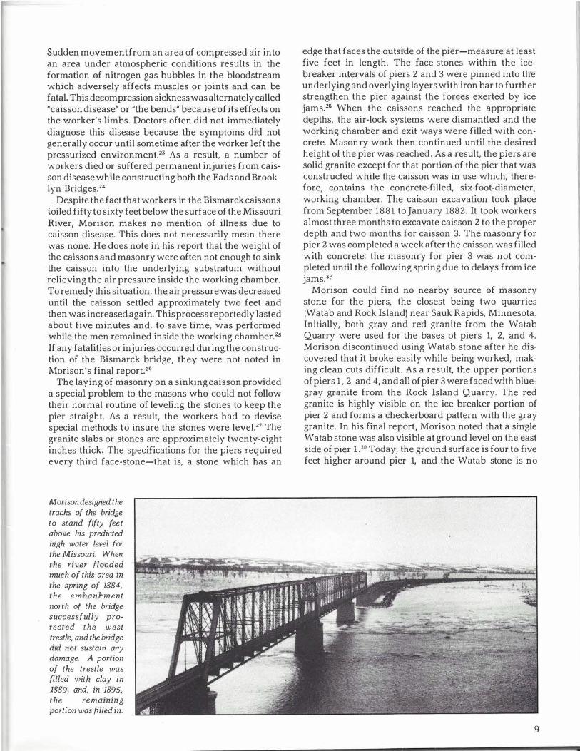
Morison designed the tracks of the bridge to stand fifty feet above his predicted high water level for the Missouri. When the river flooded much of this area in the spring of 1884, the embankment north of the bridge successfully protected the west trestle, and the bridge did not sustain any damage. A portion of the trestle was filled with clay in 1889, and, in 1895, the remaining portion was filled in.
edge that faces the outside of the pier-measure at least five feet in length. The face-stones within the icebreaker intervals of piers 2 and 3 were pinned into the underlying and overlying layers with iron bar to further strengthen the pier against the forces exerted by ice jams. 28 When the caissons reached the appropriate depths, the air-lock systems were dismantled and the working chamber and exit ways were filled with concrete. Masonry work then continued until the desired height of the pier was reached. As a result, the piers are solid granite except for that portion of the pier that was constructed while the caisson was in use which, therefore, contains the concrete-filled, six-foot-diameter, working chamber. The caisson excavation took place from September 1881 to January 1882. It took workers almost three months to excavate caisson 2 to the proper depth and two months for caisson 3. The masonry for pier 2 was completed a week after the caisson was filled with concrete; the masonry for pier 3 was not completed until the following spring due to delays from ice jams.zg
Morison could find no nearby source of masonry stone for the piers, the closest being two quarries (Watab and Rock Island) near Sauk Rapids, Minnesota. Initially, both gray and red granite from the Watab Quarry were used for the bases of piers 1, 2, and 4. Morison discontinued using Watab stone after he discovered that it broke easily while being worked, making clean cuts difficult. As a result, the upper portions of piers 1 , 2, and 4, and all of pier 3 were faced with bluegray granite from the Rock Island Quarry. The red granite is highly visible on the ice breaker portion of pier 2 and forms a checkerboard pattern with the gray granite. In his final report, Morison noted that a single Watab stone was also visible at ground level on the east side of pier 1 . 30 Today, the ground surface is four to five feet higher around pier 1, and the Watab stone is no
9
longer visible. Slabs and pieces of both Watab and Rock Island granite litter the area below pier 1 . A number of slabs are also present on the hillside above the water treatment plant and mark the area used by Morison to unload the construction material as it arrived by rail.
The superstructure of the bridge was constructed primarily of steel and wrought iron. At this point in history, most railroad bridges were being built solely with wrought iron; Morison was a pioneer in the use of steel. Morison designed the bridge spans after carefully calculating the stresses that would occur due to the weight of the rolling trains. He attempted to predict the future weights of locomotives and rail cars and designed the bridge to handle these increases. The original spans were trapezoidal and remained in existence until 1905.
The difficulty in finding good workers was another problem for Morison. He noted that ordinary laborers were paid, on average, $2.00 a day, and that
the labor in this country was of an inferior character, and very difficult to control, the men generally being indifferent as to whether they worked or not, and entirely ready to be discharged. It frequently happened that gangs of men sent out from St. Paul to work on the bridge disappeared almost as soon as they arrived.31
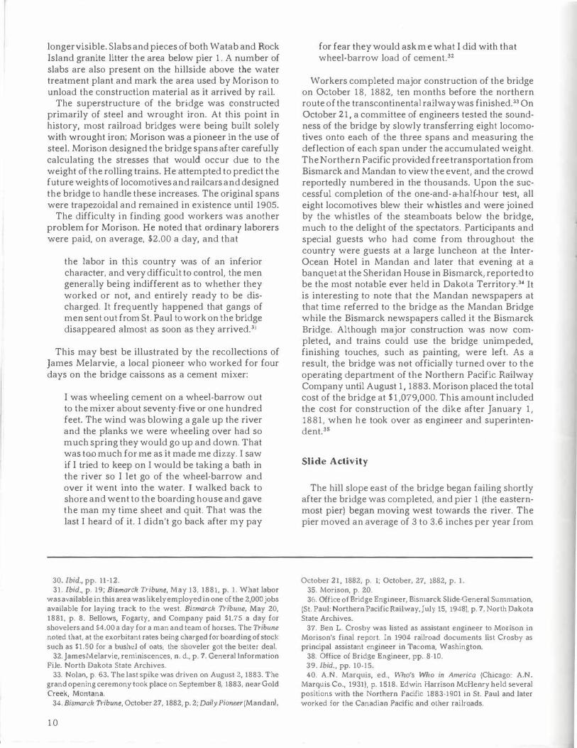
This may best be illustrated by the recollections of James Melarvie, a local pioneer who worked for four days on the bridge caissons as a cement mixer:
I was wheeling cement on a wheel-barrow out to the mixer about seventy-five or one hundred feet. The wind was blowing a gale up the river and the planks we were wheeling over had so much spring they would go up and down. That was too much for me as it made me dizzy. I saw if I tried to keep on I would be taking a bath in the river so I let go of the wheel-barrow and over it went into the water. I walked back to shore and went to the boarding house and gave the man my time sheet and quit. That was the last I heard of it. I didn't go back after my pay
30. Ibid., pp. 11-12. 31. Ibid., p. 19; Bismarck Tribune, May 13, 1881, p. 1. What labor
was available in this area was likely employed in one of the 2,000 jobs available for laying track to the west. Bismarck Tribune, May 20, 1881, p. 8. Bellows, Fogarty, and Company paid $1.75 a day for shovelers and S4.00 a day for a man and team of horses. The Tribune noted that, at the exorbitant rates being charged for boarding of stock such as $1.50 for a bushel of oats, the shoveler got the beller deal.
32. James.Melarvie, reminiscences, n. d., p. 7, General Information File. North Dakota State Archives.
33. Nolan, p. 63. The last spike was driven on August 2, 1883. The grand opening ceremony took place on September 8, 1883, near Gold Creek, Montana.
34. Bismarck Tribune, October 27, 1882, p. 2; Daily Pioneer (Mandan I,
10
for fear they would ask me what I did with that wheel-barrow load of cement.32
Workers completed major construction of the bridge on October 18, 1882, ten months before the northern route of the transcontinental railway was finished.33 On October 21, a committee of engineers tested the soundness of the bridge by slowly transferring eight locomotives onto each of the three spans and measuring the deflection of each span under the accumulated weight. The Northern Pacific provided free transportation from Bismarck and Mandan to view the event, and the crowd reportedly numbered in the thousands. Upon the successful completion of the one-and-a-half-hour test, all eight locomotives blew their whistles and were joined by the whistles of the steamboats below the bridge, much to the delight of the spectators. Participants and special guests who had come from throughout the country were guests at a large luncheon at the InterOcean Hotel in Mandan and later that evening at a banquet at the Sheridan House in Bismarck, reported to be the most notable ever held in Dakota Territory.34 It is interesting to note that the Mandan newspapers al that time referred to the bridge as the Mandan Bridge while the Bismarck newspapers called it the Bismarck Bridge. Although major construction was now completed, and trains could use the bridge unimpeded, finishing touches, such as painting, were left. As a result, the bridge was not officially turned over to the operating department of the Northern Pacific Railway Company until August 1 , 1883. Morison placed the total cost of the bridge at $ 1 ,079,000. This amount included the cost for construction of the dike after January 1 , 1881, when he took over as engineer and superintendent.35
Slide Activity
The hill slope east of the bridge began failing shortly after the bridge was completed, and pier 1 (the easternmost pier) began moving west towards the river. The pier moved an average of 3 to 3.6 inches per year from
October 21, 1882, p. l; October, 27, 1882, p. 1. 35. Morison, p. 20. 36. Office of Bridge Engineer, Bismarck Slide-General Summation,
(St. Paul: Northern Pacific Railway, July 15, 1948), p. 7, North Dakota State Archives.
37. Ben L. Crosby was listed as assistant engineer to Morison in Morison's final report. In 1904 railroad documents list Crosby as principal assistant engineer in Tacoma, Washington.
38. Office of Bridge Engineer, pp. 8-10. 39. Ibid., pp. 10-15. 40. A.N. Marquis, ed., Who's Who in America (Chicago: A.N.
Marquis Co., 1931}, p. 1518. Edwin Harrison McHenry held several positions with the Northern Pacific 1883-1901 in St. Paul and later worked for the Canadian Pacific and olher railroads.
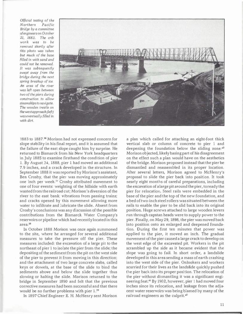
Official testing of the Northern Pacific Bridge by a committee of engineers on October 21, 1882. The crib work was to be removed shortly after this photo was taken but much of the base filled in with sand and could not be removed. It was subsequently swept away from the bridge during the next spring breakup of ice. An area of the river was left open between two of the piers during construction to allow steamships to navigate. The wooden trestle on the west approach {left) was eventually filled in with dirt.
1883 to 1887.36 Morison had not expressed concern for slope stability in his final report, and it is assumed that the failure of the east slope caught him by surprise. He returned to Bismarck from his New York headquarters in July 1885 to examine firsthand the condition of pier 1 . By August 24, 1888, pier 1 had moved an additional 7.9 inches, and a crack developed in the structure. In September 1888 it was reported by Morison's assistant, Ben Crosby, that the pier was moving approximately one inch per week. 37 Crosby attributed movement to one of four events: weighting of the hillside with earth wasted from the railroad cut; Morison's diversion of the river to the east bank; vibrations from passing trains; and cracks opened by this movement allowing more water to infiltrate and lubricate the slide. Absent from Crosby's conclusions was any discussion of the possible contributions from the Bismarck Waler Company's reservoirs or pipeline which had recently located in this area.38
In October 1888 Morison was once again summoned to the site, where he arranged for several additional measures lo take the pressure off the pier. These measures included: lhe excavation of a large pit to the northeast of pier 1 to isolate the pier from the slide; the depositing of the sediment from the pit on the west side of the pier to prevent it from moving in this direction; and the attachment of two large concrete slabs, called keys or dowels, at the base of the slide to bind the sediments above and below lhe slide logether thus slowing or halting the slide. Morison returned to the bridge in September 1890 and felt that the previous corrective measures bad been successful and that there would be no further problems with pier 1 .39
In 1897 Chief Engineer E. H. McHenry sent Morison
a plan which called for attaching an eight-foot thick vertical slab or column of concrete to pier 1 and deepening the foundation below the sliding zone.40
Morison objected, likely basing part of his disagreement on the effect such a plan would have on the aesthetics of the bridge. Morison proposed instead that the pier be dismantled and reassembled in its proper location. After several letters, Morison agreed to McHenry's proposal to slide the pier back into position. It took nearly eight months of careful preparations, including the excavation of a large pit around the pier, to ready the pier for relocation. Steel rails were embedded in the base of the pier and the lop of the new foundation, and a bed of two-inch steel rollers was situated between the rails to enable the pier to be slid back into its original position. Huge screws attached to large wooden levers run through capstan heads were to supply power to the pier. Finally, on May 29, 1898, the pier was moved back into position onto an enlarged and deepened foundation. During the first ten minutes that power was applied to the pier, it moved an inch. The gradual movement of the pier caused a large crack to develop on the west edge of the excavated pit. Workers in the pit scrambled up the side as it became evident that lhe slope was going to fail. In short order, a landslide developed in this area sending a mass of earth crashing into the west side of the pier. Onlookers and workers scurried for their Jives as the landslide quickly pushed the pier back into its proper position. The relocation of the pier without dismantling it was a significant engineering feat.41 By 1902, however, pier 1 had moved four inches since its relocation, and leakage from the adja cent water reservoirs was being blamed by many of the railroad engineers as the culprit.42
11
•
City Reservoirs
The pipe and pump house for the Bismarck Water Company were located just south of the bridge and went into service just as the bridge was being completed. The ten-inch main crossed under the tracks near pier 1 and ran up the hill 300 feet north. The pipe was reported to be leaking immediately after it was installed, but it was not known whether slope failure had caused the pipe to leak or if the leaking pipe had contributed to the initial movement of the slope.43
Whatever the case, the pipeline crossed the area of slope failure, and leakage from the pipeline undoubtedly added instability to an already unstable area.
In 1886 the Bismarck Water Company constructed three one-million-gallon reservoirs on the top of a hill approximately 750 feet northeast of pier 1 . In May 1894 Chief Engineer E. H. McHenry warned that the Bismarck Water Company's pumping station, leaking pipeline, and reservoir were greatly endangering the bridge. 44
Speculation was that the reservoirs were leaking 50,000 to 60,000 gallons of water daily. Since the water company had not completed purchase of the land from the railroad, it was directed to remove its intake and pipe to a new location and to repair the reservoir. By November of that year, McHenry noted that the reservoirs had
been repaired. 45
Ben Crosby's 1888 report on possible causes for the movement of pier 1 did not mention the reservoirs as a possible contributor to slope instability in this area. This was a curious omission because many of the engineers and geologists employed by the railroad were pointing their fingers at the water company. As Morison's assistant, Crosby no doubt consulted with Morison before he sent out his report. In 1898 Morison admitted to having a financial interest in the Bismarck Water Company, noting he had recently sold it. It was later reported that Morison and Mr. Corthel (or Corthill) oversaw construction of the waterworks.46 Morison's financial stake in the Bismarck Water Company certainly would explain his reluctance to blame the reservoirs and pipeline for the slope stability problems. This is unfortunate, because early action by the water company might have increased slope stability in this area and saved the Northern Pacific a considerable amount of money.
In 1899 a frustrated Chief Engineer McHenry urged legal action against the water company. A railroad report states that efforts to take care of the leakage from the reservoirs met with the usual promises, evasions, and postponements from the Bismarck Water Company. Therefore, in the fall of 1902, the engineering department of the Northern Pacific took it upon them-
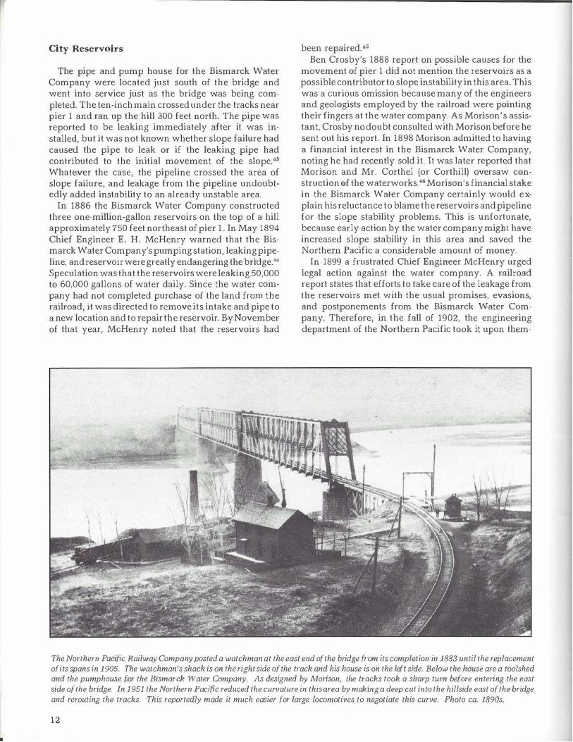
The Northern Pacific Railway Company posted a watchman at the east end of the bridge from its completion in 1883 until the replacement of its spans in 1905. The watchman's shack is on the right side of the track and his house is on the left side. Below the house are a too/shed and the pumphouse for the Bismarck Water Company. As designed by Morison, the tracks took a sharp turn before entering the east side of the bridge. In 1951 the Northern Pacific reduced the curvature in this area by making a deep cut into the hillside east of the bridge and rerouting the tracks. This reportedly made it much easier for large locomotives to negotiate this curve. Photo ca. 1890s.
12
selves to look for possible relocation sites for the reservoirs. The railroad found what theythoughtwould be an acceptable location northeast of the existing site and estimated the cost of relocation at $46,500.47
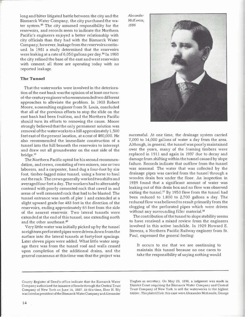
By this time, Alexander McKenzie, also known as the Boss of North Dakota, Alexander the Great, and the Bismarck Boomer, had become the principal owner in the water company. The story of how McKenzie and a few close friends acquired title to the Bismarck Water Company is surrounded by mystery and intrigue. It reportedly involved the mysterious disappearance of an official record book from the office of the Burleigh County Register of Deeds and the return of the title with names other than the originals.48 It is generally believed that the Bismarck Water Company had little or no available capital, despite the fact that McKenzie was regarded as one of the wealthiest men in the Dakotas. In 1903 a test was made at McKenzie's request that demonstrated the reservoirs were leaking approximately 18,000 gallons a day. Six months later, McKenzie discounted or ignored these findings and was once again insisting that the reservoirs were not leaking.49 The following year, Chief Engineer E. J. Pearson noted that the walls of the reservoirs were severely cracked down to a depth of eight and perhaps ten feet as a result of ice damage.50
The reluctance of the railroad to take the Bismarck Water Company to court may have resulted from the close ties between McKenzie and the heads of the Northern Pacific Railway Company and the railroad's possible dependence upon him to supply water for its steam locomotives. It was reported that McKenzie did provide free water to "his old cronies at the Northern Pacific Railway."51 But even more importantly, McKenzie had been an agent for the Northern Pacific and was an important political ally for the railroad, often serving as their "special" representative in matters involving federal, state, and local governments.52
McKenzie died in 1922. One year later, following a
41. Bismarck Tribune, May 30, 1898, p. 3. The Tribune reported that a landslide was responsible for moving the pier out of its proper location, and a landslide was responsible for moving it back.
42. Office of Bridge Engineer, pp. 18-20. 43. George E. Burgess, N.P.R.R. Topographical Map of East Bank
of Missouri River at Bismarck Bridge (St. Paul: Office of Chief Engineer, May 31, 1894), plate 1, North Dakota State Archives.
44. Office of Bridge Engineer, p. 15. 45. Ibid., p. 15. 46. Ibid., p. 11; J.M. Edgerley, Letter to Alexander McKenzie, May
10, 1888. 47. Office of Bridge Engineer, pp. 15-21. 48. David B. Baglien, The McKenzie Era, A Political History of North
Dakota From 1880 to 1920 {Fargo, North Dakota: unpublished master's thesis, North Dakota Agricultural College, 19551, p. 13. Joseph A. Jackson, Bismarck Boomer: The Amazing Career of Alexander McKenzie (unpublished mam1script, North Dakota State Archives, 1954), pp. 105and 280. Jackson states that on May 27, 1886, the Bismarck Water
-·-�
O Y
0 Moniterir,9 'A'e!I
� Mot,"01 Nr.\OVed to lltObi!lze tl i<Se � 1,&ct..-lol ''"'°"•� for !/0<:k. ,,ofiQ,!Vl'"l...,I
1-- --'--0 --ii
' loo IL
so "'
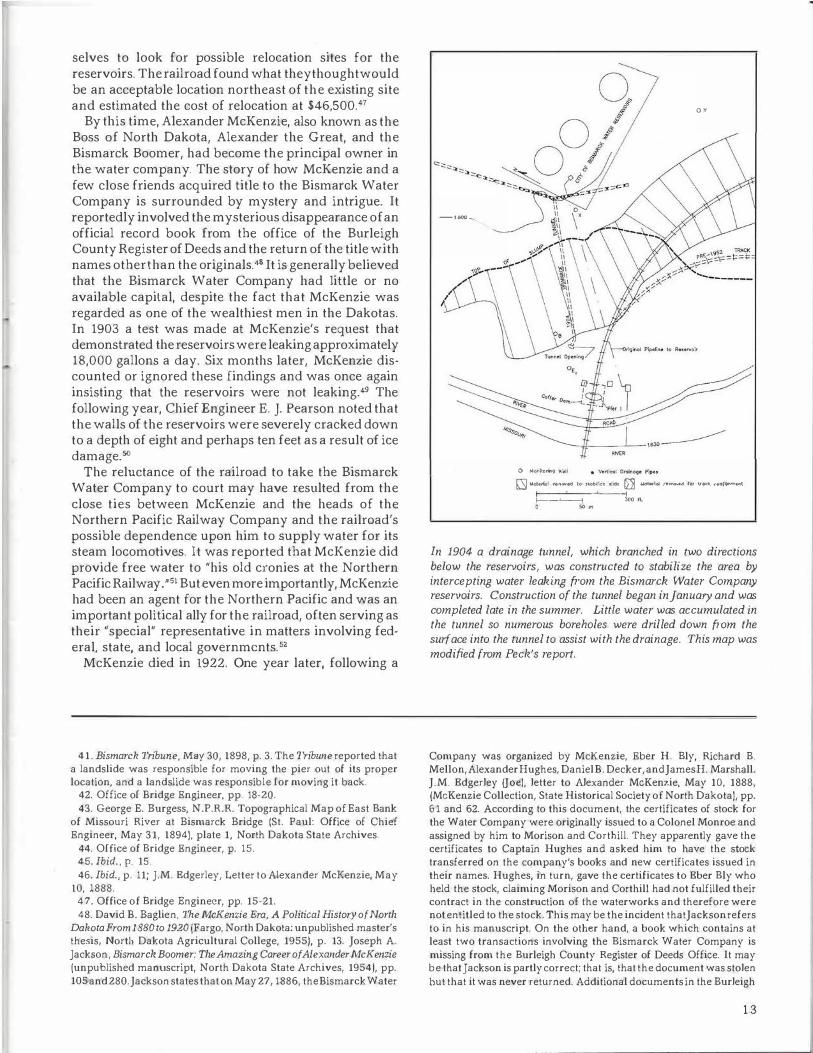
In 1904 a drainage tunnel, which branched in two directions below the reservoirs, was constructed to stabilize the area by intercepting water leaking from the Bismarck Water Company reservoirs. Construction of the tunnel began in January and was completed late in the summer. Little water was accumulated in the tunnel so numerous boreholes were drilled down from the surface into the tunnel to assist with the drainage. This map was modified from Peck's report.
Company was organized by McKenzie, Eber H. Bly, Richard B. Mellon, Alexander Hughes, Daniel B. Decker, and James H. Marshall. J.M. Edgerley Uoe), letter to Alexander McKenzie, May 10, 1888, {McKenzie Collection, State Historical Society of North Dakota), pp. 61 and 62. According to this document, the certificates of stock for the Water Company were originally issued to a Colonel Monroe and assigned by him to Morison and Cortbill. They apparently gave the certificates to Captain Hughes and asked him to have the stock transferred on the company's books and new certificates issued in their names. Hughes, in turn, gave the certificates to Eber Bly who held the stock, claiming Morison and Corthill had not fulfilled their contract in the construction of the waterworks and therefore were not entitled to the stock. This may be the incident that Jackson refers to in his manuscript. On the other hand, a book which contains at least two transactions involving the Bismarck Water Company is missing from the Burleigh County Register of Deeds Office. It may be that Jackson is partly correct; that is, that the document was stolen but that it was never returned. Additional documents in the Burleigh
1 3
long and bitter litigated battle between the city and the Bismarck Water Company, the city purchased the water system.53 The city assumed responsibility for the reservoirs, and records seem to indicate the Northern Pacific's engineers enjoyed a better relationship with city officials than they had with the Bismarck Water Company; however, leakage from the reservoirs continued. In 1951 a study determined that the reservoirs were leaking at a rate of 6,050 gallons per day.54 In 1960 the city relined the base of the east and west reservoirs with cement; all three are operating today with no reported leakage.
The Tunnel
That the waterworks were involved in the deterioration of the east bank was the opinion of at least one turnof-the-century engineer who recommended two different approaches to alleviate the problem. In 1903 Robert Moore, a consulting engineer from St. Louis, concluded that all of the previous efforts to stop the slide on the east bank had been fruitless, and the Northern Pacific should turn its efforts to removing the cause. Moore strongly believed that the only permanent solution was removal of the waterworks to a hill approximately 1 ,500 feet east of the present location, at a cost of $60,000. He also recommended the immediate construction of a tunnel into the hill beneath the reservoirs to intercept and draw out all groundwater on the east side of the bridge.55
The Northern Pacific opted for his second recommendation, and crews, consisting of two miners, one or two laborers, and a carpenter, hand dug a four-foot by sixfoot, timber-lagged mine tunnel, using a horse to haul out the rock. The crews generally worked two shifts and averaged four feet a day. The workers had to alternate! y contend with poorly cemented rock that caved in and areas of well cemented rock that had to be blasted. The tunnel entrance was north of pier 1 and extended at a slight upward grade for 483 feet in the direction of the reservoirs, ending approximately 65 feet from the side of the nearest reservoir. Two lateral tunnels were extended at the end of this tunnel, one extending north and the other southeast.56
Very little water was initially picked up by the tunnel so eighteen perforated pipes were driven down from the surface into the lateral tunnels at forty-foot spacings. Later eleven pipes were added. What little water seepage there was from the tunnel roof and walls ceased upon completion of the additional drains, and the general consensus at this time was that the project was
County Register of Deed's office indicate that the Bismarck Water Company authorized the issuance of bonds through the Central Trust Company of New York on June 14, 1887. At this time, Eber H. Bly was listed as president of the Bismarck Water Company and Alexander
14
Alexander
McKenzie,
1886
successful. At one time, the drainage system carried 7,000 to 14,000 gallons of water a day from the area. Although, in general, the tunnel was poorly maintained over the years, many of the framing timbers were replaced in 1911 and again in 1937 due to decay and damage from shifting within the tunnel caused by slope failure. Records indicate that outflow from the tunnel was seasonal. The water that was collected by the drainage pipes was carried from the tunnel through a wooden drain box under the floor. An inspection in 1929 found that a significant amount of water was leaking out of this drain box and no flow was observed exiting the tunnel.57 By 1950 flow from the tunnel had 'been reduced to 1,800 to 2,700 gallons a day. The reduced flow was believed to result primarily from the clogging of the perforated pipes which were driven without any surrounding filler material.58
The contribution of the tunnel to slope stability seems to have received a mixed review from the engineers involved in this active landslide. In 1929 Howard E. Stevens, a Northern Pacific Railway engineer from St. Paul, expressed the general feeling:
It occurs to me that we are continuing to maintain this tunnel because no one cares to take the responsibility of saying nothing would
Hughes as secretary. On May 23, 1896, a judgment was made in District Court requiring the Bismarck Water Company and Central Trust Company of New York to sell the waterworks to the highest bidder. The plaintiffs in this case were Alexander McKenzie, George
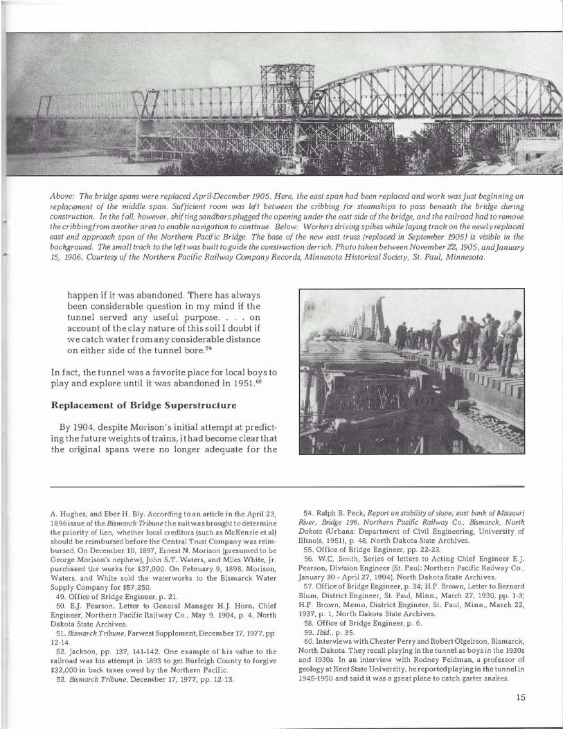
Above: The bridge spans were replaced April-December 1905. Here, the east span had been replaced and work was just beginning on replacement of the middle span. Sufficient room was left between the cribbing for steamships to pass beneath the bridge during construction. In the fall, however, shifting sandbars plugged the opening under the east side of the bridge, and the railroad had to remove the cribbing from another area to enable navigation to continue. Below: Workers driving spikes while laying track on the newly replaced east end approach span of the Northern Pacific Bridge. The base of the new east truss (replaced in September 1905} is visible in the background. The small track to the left was built to guide the construction derrick. Photo taken between November 22, 1905, and January 15, 1906. Courtesy of the Nor thern Pacific Railway Company Records, Minnesota Historical Society, St. Paul, Minnesota.
happen if it was abandoned. There has always been considerable question in my mind if the tunnel served any useful purpose. . . . on account of the clay nature of this soil I doubt if we catch water from any considerable distance on either side of the tunnel bore. 59
In fact, the tunnel was a favorite place for local boys to play and explore until it was abandoned in 1951.60
Replacement of Bridge Superstructure
By 1904, despite Morison's initial attempt at predicting the future weights of trains, i t had become clear that the original spans were no longer adequate for the
A. Hughes, and Eber H. Bly. According to an article in the April 23, 1896 issue of the Bismarck Tribune the suit was brought to determine the priority of lien, whether local creditors (such as McKenzie et al) should be reimbursed before the Central Trust Company was reimbursed. On December 10, 1897, Ernest N. Morison (presumed to be George Morison's nephew), John S.T. Waters, and Miles White, Jr. purchased the works for $37,000. On February 9, 1898, Morison, Waters, and White sold the waterworks to the Bismarck Water Supply Company for $57,250.
49. Office of Bridge Engineer, p. 21. 50. E.J. Pearson, Letter to General Manager H.J. Horn, Chief
Engineer, Northern Pacific Railway Co., May 9, 1904, p. 4, North Dakota State Archives.
51. Bismarck Tribune, Farwest Supplement, December 17, 1977, pp. 12-14.
52. Jackson, pp. 137, 141-142. One example of his value to the railroad was his attempt in 1893 to get Burleigh County to forgive $32,000 in back taxes owed by the Northern Pacific.
53. Bismarck Tribune, December 17, 1977, pp. 12-13.
54. Ralph B. Peck, Report on stability of slope; east bank of Missouri River, Bridge 196, Northern Pacific Railway Co., Bismarck, North Dakota (Urbana: Department of Civil Engineering, University of Illinois, 1951), p. 48, North Dakota State Archives.
55. Office of Bridge Engineer, pp. 22-23. 56. W.C. Smith, Series of letters to Acting Chief Engineer E.J.
Pearson, Division Engineer (St. Paul: Northern Pacific Railway Co., January 20 - April 27, 1904), North Dakota State Archives.
57. Office of Bridge Engineer, p. 34; H.F. Brown, Letter to Bernard Blum, District Engineer, St. Paul, Minn., March 27, 1930, pp. 1-3; H.F. Brown, Memo, District Engineer, St. Paul, Minn., March 22, 1937, p. 1, North Dakota State Archives.
58. Office of Bridge Engineer, p. 6. 59. ibid., p. 35. 60. Interviews with Chester Perry and Robert Olgeirson, Bismarck,
North Dakota. They recall playing in the tunnel as boys in the 1920s and 1930s. In an interview with Rodney Feldman, a professor of geology at Kent State University, he reported playing in the tunnel in 1945-1950 and said it was a great place to catch garter snakes.
15
•
heavier locomotives, and a decision had to be made regarding the Bismarck bridge. The railroad engineers reviewed the whole question of slope and bank stabilization and bridge relocation. They explored several options, including the construction of a new, heavier bridge in another location, increasing the width of the river beneath the bridge and adding an additional bridge span, and replacing or reinforcing the existing bridge spans. The railroad dismissed expansion of both the river and the bridge because their engineers felt it would increase the danger of ice jams forming beneath the bridge. Instead, the railroad decided to replace the spans on the existing bridge, and Ralph Modjeski, a consulting engineer from Chicago, was hired to design the new spans.
The Northern Pacific could not afford to have the bridge closed to traffic during the eight months it would take to replace the spans. Therefore, railroad engineers designed wooden cribbing or falseworks which not only supported each span as it was replaced but was also able to support the weight of passing trains. This resulted in the unprecedented feat of allowing trains to continue running with little or no delay while the bridge was
61. Bismarck Weekly Tribune, March 9, 1906, p. l; Resident Engineer Nickerson, final report to Consulting Engineer Ralph Modjeski, (Bismarck: Northern Pacific Railway Co.). January 24, 1906, p. 17.
62. Bisrnarclz Weekly Tribune, March 9, 1906, p. 1. The Tribune estimated cost of respan at $500,000; Nickerson, pp. 14-18. Most of the old bridge was salvaged for repair parts in other bridges throughout the country. The timber from the cribbings was also salvaged. Timber piles were cut off at the water line and the remnants can be
16
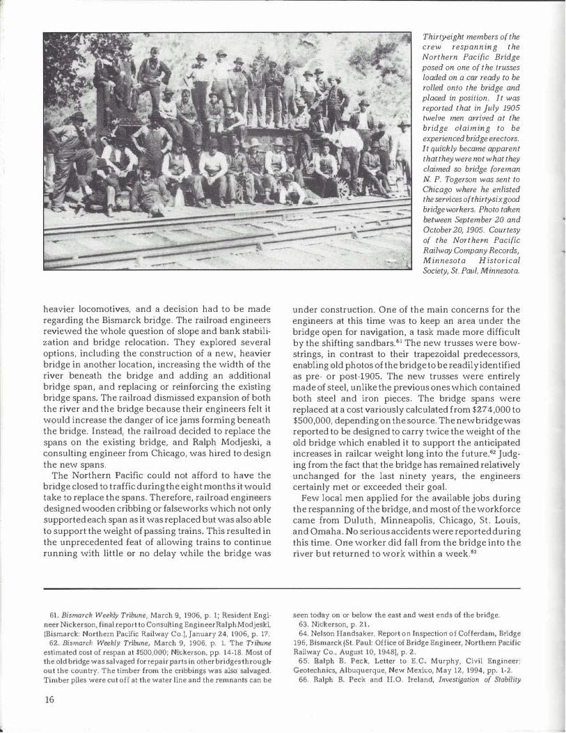
Thirty-eight members of the crew respanning the Northern Pacific Bridge posed on one of the trusses loaded on a car ready to be rolled onto the bridge and placed in position. It was reported that in July 1905 twelve men arrived at the bridge claiming to be experienced bridge erectors. It quickly became apparent that they were not what they claimed so bridge foreman N. P. Togerson was sent to Chicago where he enlisted the services of thirty-six good bridge workers. Photo taken between September 20 and October 20, 1905. Courtesy of the Northern Pacific Railway Company Records, Minnesota Historical Society, St. Paul, Minnesota.
under construction. One of the main concerns for the engineers at this time was to keep an area under the bridge open for navigation, a task made more difficult by the shifting sandbars.61 The new trusses were bowstrings, in contrast to their trapezoidal predecessors, enabling old photos of the bridge to be readily identified as pre- or post-1905. The new trusses were entirely made of steel, unlike the previous ones which contained both steel and iron pieces. The bridge spans were replaced at a cost variously calculated from $274,000 to $500,000, depending on the source. The new bridge was reported to be designed to carry twice the weight of the old bridge which enabled it to support the anticipated increases in railcar weight long into the future.62 Judging from the fact that the bridge has remained relatively unchanged for the last ninety years, the engineers certainly met or exceeded their goal.
Few local men applied for the available jobs during the respanning of the bridge, and most of the workforce came from Duluth, Minneapolis, Chicago, St. Louis, and Omaha. No serious accidents were reported during this time. One worker did fall from the bridge into the river but returned to work within a week.63
seen today on or below the east and west ends of the bridge. 63. Nickerson, p. 21. 64. Nelson Handsaker, Report on Inspection of Cofferdam, Bridge
196, Bismarck {St. Paul: Office of Bridge Engineer, Northern Pacific Railway Co., August 10, 1948), p. 2.
65. Ralph B. Peck, Letter to E.C. Murphy, Civil Engineer: Geotechnics, Albuquerque, New Mexico, May 12, 1994, pp. 1-2.
66. Ralph B. Peck and H.O. Ireland, Investigation of Stability
The Final Solution
During the years, the east slope continued to move, undergoing an accelerated period of movement from 1947 to 1950. For some time, the Northern Pacific had contemplated realigning the tracks on the east side of the bridge. In 1951 they decided it would be a good time to reassess the slide, especially in light of the advances that had been made in understanding slope movement. 64 During this same time, the Association of American Railroads had a contract with the University of Illinois to investigate stability problems at the request of the various railroads in the United States and Canada. As a result of this contract, Dr. Ralph B. Peck, a widely respected engineering professor at the University of Illinois, investigated the slide to determine a solution to eliminate or greatly reduce the slope failure in this area, thus retarding the movement on pier l . Coincidentally, Dr. Peck's parents homesteaded in the Dakota Territory near Mitchell, South Dakota, and one of his father's first assignments as a railroad bridge engineer was to design the steel tail-span on the east end of the Bismarck bridge in 1907.65 In 1991 the east tail-span was replaced with three sets of steel piles.
Dr. Peck evaluated the seventy years of information and hypotheses from the site and concluded that Morison's alteration of the river channel and trimming of the hillside were the main causes for failure of this slope. From his study of the area, Peck surmised that the slopes along the east side of the bridge were likely unstable prior to bridge construction. Therefore, the slope would not require much disturbance during bridge construction to start it moving. Peck determined that the only way to obtain stability at this site was to remove a substantial amount of the hillside above the bridge and to recontour the base of the slope. The Northern Pacific concurred with Peck's recommendations, and dirt work began in the fall of 1951 and was completed the following year.66 Even after these efforts, the slide continued to move, albeit at a much reduced rate. In 1963, the year the railroad discontinued keeping records on the site, the slide was moving at a rate of approximately one-third of an inch a year.
The Bismarck bridge was originally built for a cost of $1.1 million. In 1905 the original spans were replaced at a cost of $274,000-$500,000. No estimates are available of the cost to the Northern Pacific to repair and maintain pier 1 and the slopes adjacent to the east end of the
Problems, (Proceedings of the American Railway Engineering Association, 1953), Vol. 54, pp. 1125-1127; and Elmer W. Brooker and Ralph B. Peck, Rational Design Treatment of Slides in Over Consolidated Clays and Clay Shales (Canadian Geolechnical JO\tmal, September, 19931, Vol. 30, pp. 533-534.
67. Bismarck Tribune, January 28, 1881, p. l, and February 4, 1881, p. l. The need for a Bismarck waterworks was front page news when Morison arrived in Bismarck lo supervise construction of the bridge.
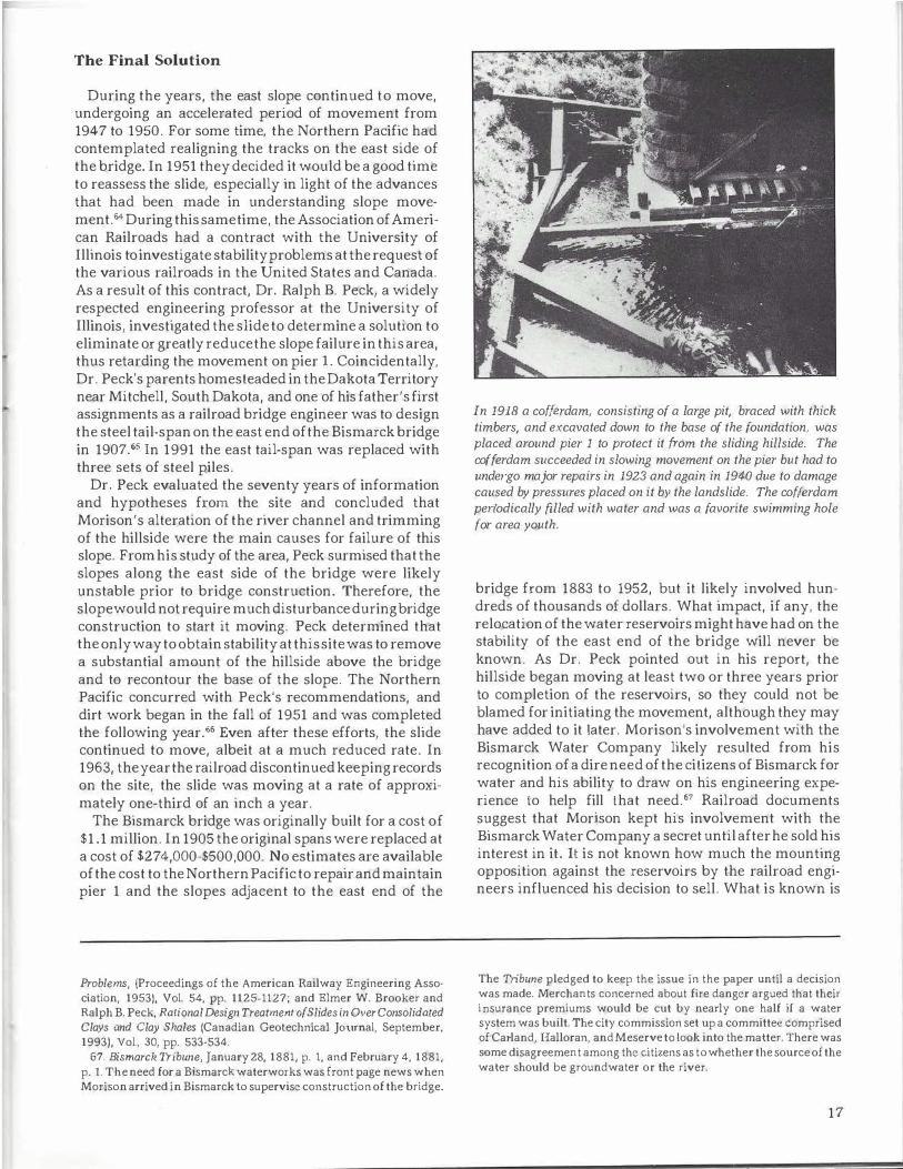
In 1918 a cofferdam, consisting of a large pit, braced with thick timbers, and excavated down to the base of the foundation, was placed around pier 1 to protect it from the sliding hillside. The cofferdam succeeded in slowing movement on the pier but had to unde,go major repairs in 1923 and again in 1940 due to damage caused by pressures placed on it by the landslide. The cofferdam periodically filled with water and was a favorite swimming hole for area youth.
bridge from 1883 to 1952, but it likely involved hundreds of thousands of dollars. What impact, if any, the relocation of the water reservoirs might have had on the stability of the east end of the bridge will never be known. As Dr. Peck pointed out in his report, the hillside began moving at least two or three years prior to completion of the reservoirs, so they could not be blamed for initiating the movement, although they may have added to it later. Morison's involvement with the Bismarck Water Company likely resulted from his recognition of a dire need of the citizens of Bismarck for water and his ability to draw on his engineering experience to help fill that oeed.67 Railroad documents suggest that Mortson kept his involvement with the Bismarck Water Company a secret until after he sold his interest in it. It is not known how much the mounting opposition against the reservoirs by the railroad engineers influenced his decision to sell. What is known is
The Tribune pledged to keep the issue in the paper until a decision was made. Merchants concerned about fire danger argued that their insurance premiums would be cut by nearly one half if a water system was built. The city commission set up a committee comprised of Ca1·land, Halloran, and Meserve to look into the matter. There was some disagreement among the citizens as tow hether the source of the water should be groundwater or the river.
17
•
68. J.M. Edgerley, letter to Alexander McKenzie, Alexander McKenzie Papers, May 18, 1888, p. 69, North Dakota State Archives. An interesting and perhaps insightful example of how McKenzie and the Bismarck Water Company operated is provided by Edgerley's letter which describes an incident in which the Bismarck Water Company almost turned off the water to the territorial governor. The governor had previously complained that bis water bill was too high and was delinquent in his payments. One of McKenzie's associates with the Water Company, Eber H. Bly {of the Sheridan Housel, gave orders for the water to be shut off at the governor's residence but Edgerley intervened and resolved the matter before the water was turned off. It was reported that Bly was trying to get even with the
18
the frustration of some of these same engineers, who were convinced that the reservoirs were harming the bridge but were unable to get Alexander McKenzie to act or to prompt Northern Pacific officers into forcing McKenzie into action.68
For nearly forty years, the Northern Pacific Bridge stood as the only crossing over the Missouri River in this area. With its dark spans, tall masonry piers, and sleek ice breakers, the Bismarck railroad bridge is arguably the most majestic of the four bridges that now span the Missouri River at Bismarck. The bridge stands today as a testament to George Morison and the men who built it, especially those brave souls who toiled in the dimly lit caissons. Perhaps Morison himself summoned up their accomplishment best when he said, "Peace hath her victories, no less renowned than war."69 !NDI
Acknowledgments The author would like to thank Dr. Ralph Peck, Professor Emeritus, University of Illinois; Todd Strand and Jim Davis, State Historical Society of North Dakota; Mel Bullinger and Brad Wright, Engineering Department, City of Bismarck; Steve Nielsen, Minnesota Historical Society; Laurie Morrow, Montana Historical Society; Trent Heinemeyer, Bismarck, and Gerald Knudson, Mandan, for providing material for this article.
About the Author Edward C. Murphy is a geologist with the North Dakota Geological Survey. A native of Bismarck, he earned an associate of arts degree from Bismarck State College, and bachelor's and master's degrees in geology from the University of North Dakota. This article resulted from an ongoing investigation of slope stability in the Bismarck-Mandan area.
governor for a bill concerning committee room rent that •went into the wastebasket• during the last legislative session. Following the incident Bly reportedly went around Bismarck sarcastically remarking the Governor •is a hell of a nice man, too mean to pay his water bill..
69. Bismarck Tribune, October 27, 1882, p. 2; Nolan, p. 36. Morison concluded his remarks at the banquet given the evening of the successful testing of the bridge with those words. The phrase was apparently borrowed from a Northern Pacific advertisement brochure written in 1871 by Jay Cooke of the NP Land Grant and Immigration Department.
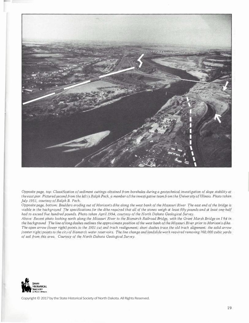
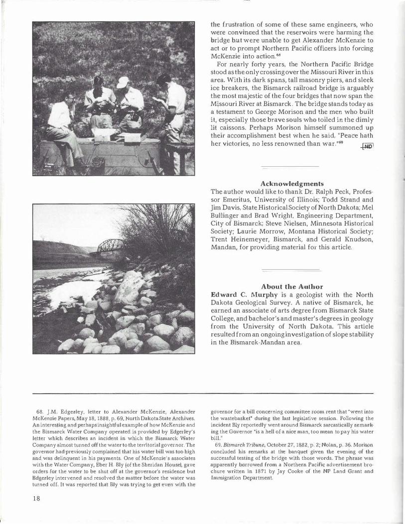
Opposite page, top: Classification of sediment cuttings obtained from boreholes during a geotechnical investigation of slope stability at the east pier. Pictured second from the left is Ralph Peck, a member of the investigative team from the University of Illinois. Photo taken July 1951, courtesy of Ralph B. Peck. Opposite page, bottom: Boulders eroding out of Morison's dike along the west bank of the Missouri River. The east end of the bridge is visible in the background. The specifications for the dike required that all of the stones weigh at least fifty pounds and at least one-half had to exceed five hundred pounds. Photo taken April 1994, courtesy of the North Dakota Geological Survey. Above: Recent photo looking north along the Missouri River to the Bismarck Railroad Bridge, with the Grant Marsh Bridge on I-94 in the background. The line of long dashes outlines the approximate position of the west bank of the Missouri River prior to Morison's dike. The open arrow flower right) points to the 1951 cut and track realignment; short dashes trace the old track alignment; the solid arrow {center right} points to the city of Bismarck water reservoirs. The line change and landslide work required removing 760,000 cubic yards of soil from this area. Courtesy of the North Dakota Geological Survey.
19
Copyright © 2017 by the State Historical Society of North Dakota. All Rights Reserved.