the north spur quick clay instability & landslide problem ... · pdf fileas can be seen on...
TRANSCRIPT

The North Spur Quick Clay Instability & Landslide Problem: The weak link in Nalcor’s Muskrat Falls Project
Cabot Martin St. John’s, Newfoundland March 9, 2013

Table of Contents
Note on Sources 3 Executive Summary 4 The North Spur & its role in Muskrat Falls Project 7 The North Spur Landslide of 1978 15 Glacio-marine clay and its dangers 29 JRP & NrCan in the debate on the North Spur 45 The Edwards Island Landslide of 2010 54 NRCan presentation to JRP Public Hearing 62 Nalcor North Spur Technical Note 73 SNC 2013 North Spur Stabilization Project 82
Current Situation 87 2

NOTE ON SOURCES
3
The following presentation is based on public sources all of which are available on line. Where possible an active link is provided to the document referenced. The vast majority of these documents were generated by hearings and reviews before the Federal Provincial Joint Review Panel (JRP) and the NL PUB, both of whom reviewed the Muskrat Falls Project and found the information provided by Nalcor to be incomplete and so did not approve it. Free access to these documents proves the value of these beleaguered democratic processes. An active link to an important Norwegian video of the Rissa landslide of 1978 is on slide 41. A chronology of key events and Further References will be added.
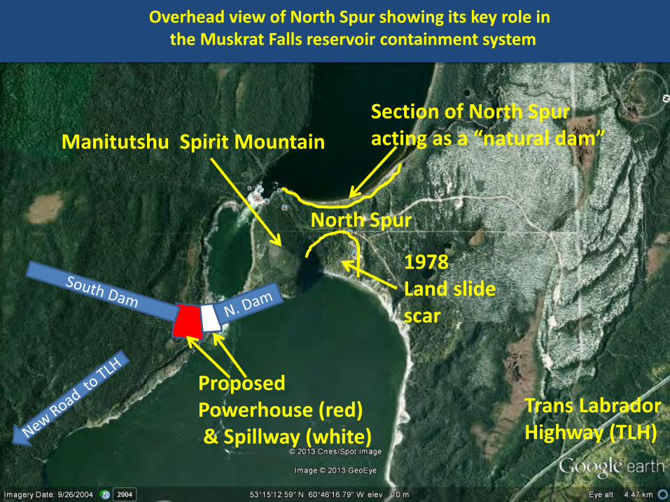
The proposed 825 MW Muskrat Falls hydro project is located in the Lower Churchill River Valley in central Labrador. The project consists of an existing natural feature (the North Spur) and two new concrete dams . The North Spur would provide a major part of the river impoundment system (next slide). The current project ,and all alternatives, must use the North Spur. The ground conditions at the North Spur are very unstable as they include significant amounts of glacio-marine clay (Quick Clay) that is highly prone to liquefaction and failure. A significant landslide took place at the North Spur in 1978 with lesser slides in 1980 and 1981. A series of other major slides have taken place both upriver and downriver from Muskrat Falls, the latest in 2010. As of March 1, 2013, Nalcor had not conducted the geotechnical field work and collected the data necessary to fully assess the North Spur instability problem and design a suitable, cost effective solution.
1 of 2
EXECUTIVE SUMMARY
4
North Spur
Trans Labrador Highway (TLH)
Proposed Powerhouse (red) & Spillway (white)
Manitutshu Spirit Mountain
Overhead view of North Spur showing its key role in the Muskrat Falls reservoir containment system
Section of North Spur acting as a “natural dam”
1978 Land slide scar
5

Thus Nalcor is not yet in a position to know what the cost of an acceptable solution to the North Spur instability problem will be. Yet the Muskrat Falls project was sanctioned in December 2012 without an answer to the North Spur issue. Nalcor’s EPCM contractor SNC Lavalin must first carry out field work and design activities in 2013 to address the North Spur issue. This also leaves Nalcor in a position where it does not know whether a technically feasible solution can be devised for the North Spur instability problem. Without an acceptable, safe solution to the North Spur instability problem, the whole Muskrat Falls project will have to be cancelled. 2 of 2
6
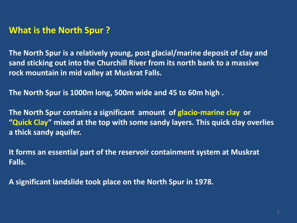
What is the North Spur ? The North Spur is a relatively young, post glacial/marine deposit of clay and sand sticking out into the Churchill River from its north bank to a massive rock mountain in mid valley at Muskrat Falls. The North Spur is 1000m long, 500m wide and 45 to 60m high . The North Spur contains a significant amount of glacio-marine clay or “Quick Clay” mixed at the top with some sandy layers. This quick clay overlies a thick sandy aquifer. It forms an essential part of the reservoir containment system at Muskrat Falls. A significant landslide took place on the North Spur in 1978.
7

NORTH SPUR
Upper Muskrat Falls
Lower Muskrat Falls Site of Proposed Power House & Dams
Trans Labrador Highway
Lower Churchill River
Manitutshu Spirit Mountain
Google Earth Image of Muskrat Falls Site looking North

• The previous slide shows on the left, the upstream section of the fresh water Lower Churchill River at an elevation of 18m above sea level.
• After dam completion, the Muskrat Reservoir will rise to 35m above sea level.
• On the right, below the Upper and Lower Muskrat Falls, is the downstream section of the Lower Churchill River at an elevation approaching 0 m above sea level.
• The impact of tidal/sea water influences immediately downstream from the North Spur seem to deserve more attention.
• Consideration of hydraulic forces on the downstream side of the North Spur are greatly complicated by ice damming .
• For a view of ice damming downstream from the North Spur see the first photo icon downstream from Muskrat Falls on Google Earth at 53 degrees 14 min 19.48 sec North; 60 degrees 46 min 38.56 sec West.
9

The next slide shows the Muskrat Falls project layout superimposed on an existing view of Muskrat Falls on Google Earth. As you can see, the North Spur is just as important to damming off the Lower Churchill River as are Nalcor’s two proposed concrete dams . Note that Manitutshu – the 120m high solid rock Innu sacred Spirit Mountain – is located between the North Spur and the area of Nalcor’s two proposed concrete dams at Muskrat Falls.
10

North Spur
Trans Labrador Highway (TLH)
Proposed Powerhouse (red) & Spillway (white)
Manitutshu Spirit Mountain
Overhead view of North Spur showing key role in Muskrat Falls reservoir containment system
Section of North Spur acting as a “natural dam”
11
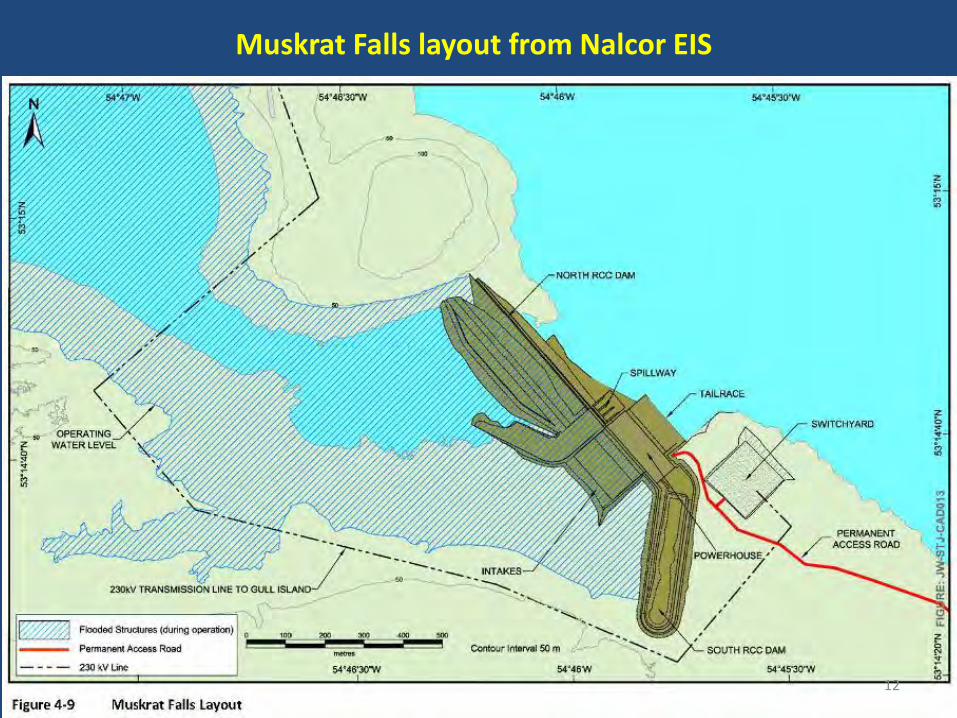
Muskrat Falls layout from Nalcor EIS
12

Nalcor Depiction of the Muskrat Falls Project from downstream (from a January 23, 2013 presentation)
North Dam (concrete) terminating on south side of Manitutshu Spirit Mountain
13
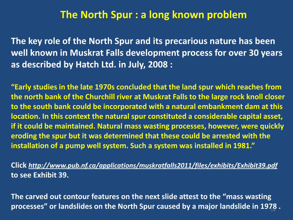
The North Spur : a long known problem The key role of the North Spur and its precarious nature has been well known in Muskrat Falls development process for over 30 years as described by Hatch Ltd. in July, 2008 : “Early studies in the late 1970s concluded that the land spur which reaches from the north bank of the Churchill river at Muskrat Falls to the large rock knoll closer to the south bank could be incorporated with a natural embankment dam at this location. In this context the natural spur constituted a considerable capital asset, if it could be maintained. Natural mass wasting processes, however, were quickly eroding the spur but it was determined that these could be arrested with the installation of a pump well system. Such a system was installed in 1981.” Click http://www.pub.nf.ca/applications/muskratfalls2011/files/exhibits/Exhibit39.pdf
to see Exhibit 39.
The carved out contour features on the next slide attest to the “mass wasting processes” or landslides on the North Spur caused by a major landslide in 1978 .
14

In February 1978, a large landslide took place on the North Spur.
15

THE MAJOR NORTH SPUR LANDSLIDE of 1978 Note the steep scalloped contour lines; Major slide of 1978 in red – lesser ones date from 1980 and 1981
Edge of slides as mapped by Hydro
16
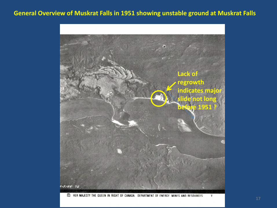
General Overview of Muskrat Falls in 1951 showing unstable ground at Muskrat Falls
Lack of regrowth indicates major slide not long before 1951 ?
17
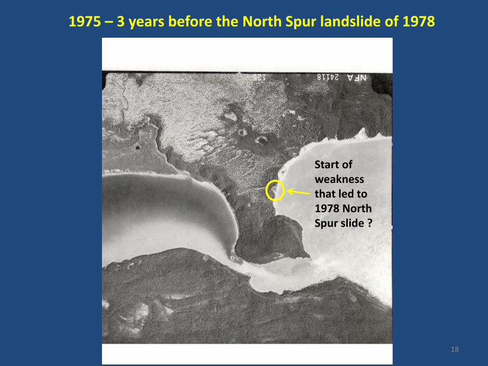
1975 – 3 years before the North Spur landslide of 1978
Start of weakness that led to 1978 North Spur slide ?
18

1988 – 10 years after the 1978 North Spur landslide
North Spur Slide area without regrowth. Trees at foot of slide indicate mass flow?
19

View in 1998 showing 20 years of growth on 1978 slide
1978 North Spur slide area partially overgrown
20

View in 2007 showing line of pumping wells
Line of 17 pumping wells installed by NL Hydro in 1981 after 1978 North Spur Landslide
21

View in 2007 showing line of slides downriver from North Spur
TLH
Series of slides downstream from Muskrat Falls

“ 7.0 RECOMMENDED SCHEME OF DEVELOPMENT 7.1 GENERAL Development of the Muskrat Falls site will include stabilization of the natural dam, called the north spur, which connects the rock knoll to the north bank of the original river valley, and power development facilities in the river channel, including diversion, reservoir control and power facilities. The stabilization of the spur is a common element to any alternative power development schemes, of which several were considered.” Click http://www.pub.nf.ca/applications/muskratfalls2011/files/exhibits/Exhibit19-MuskratFallsFeasibilityStudy1999.pdf to see Exhibit 19.
The SNC – AGRA Final Muskrat Falls Feasibility Study of 1999 also emphasised how important the North Spur was and the need for stabilization.
23

Click http://www.pub.nf.ca/applications/muskratfalls2011/files/exhibits/Exhibit19-MuskratFallsFeasibilityStudy1999.pdf to see Section 10.0 of Volume 1 at pages 178 to 192
Volume 1 of the SNC-AGRA 1999 Final Feasibility Study discussed the North Spur problem at length and proposed a set of remedial actions to prevent North Spur collapse.
24
Unfortunately the critical Jacques Whitford Geotechnical study of 1998 conducted for NL Hydro, though often referred to in various Nalcor documents, does not seem to be publically available. It is presumably contained as an appendix labeled “Volume 2: 1998 Geotechnical Investigations”. The Foreword of Volume 1 states that: “Volume 2 contains the results of the geotechnical investigations carried out in the summer of 1998 together with the relevant plates and appendices incorporated after the text of the report. This volume is presented in limited copies to be distributed per request only.” This is most unfortunate as it presumably contains the most detailed field and analytical analysis of the North Spur issue to date.
25

1978 slide
Approx level of reservoir after flooding
North Spur looking South: the filled Muskrat Falls Reservoir will flood part of the North Spur
26
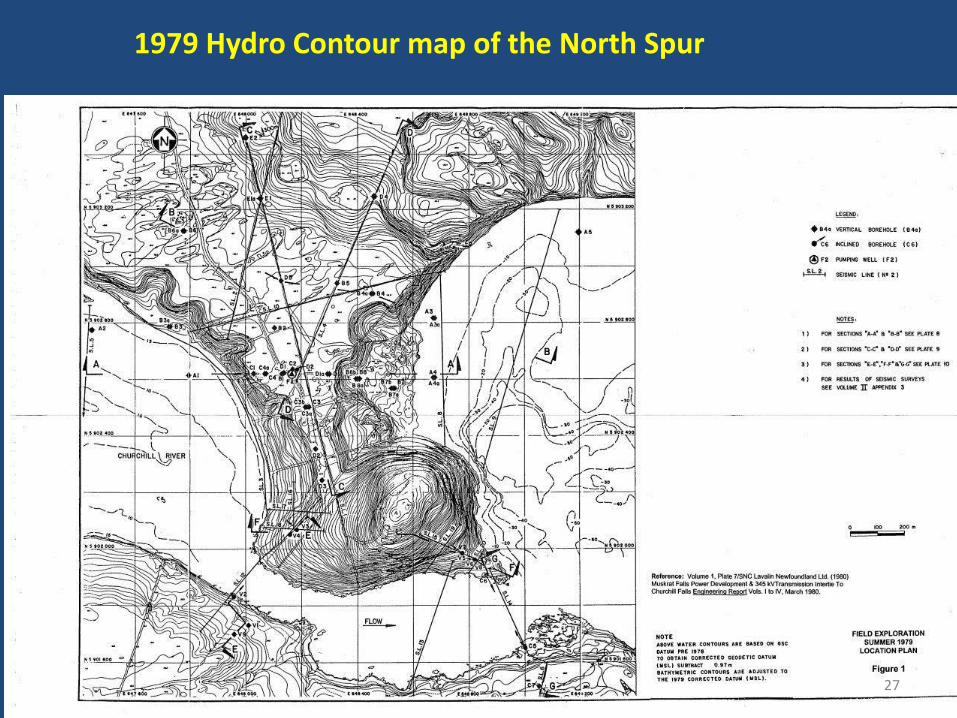
1979 Hydro Contour map of the North Spur
27

The wasting topography of the North Spur and surrounding area is well demonstrated by this low resolution topographical Map. Source : Topographic Maps Canada
28
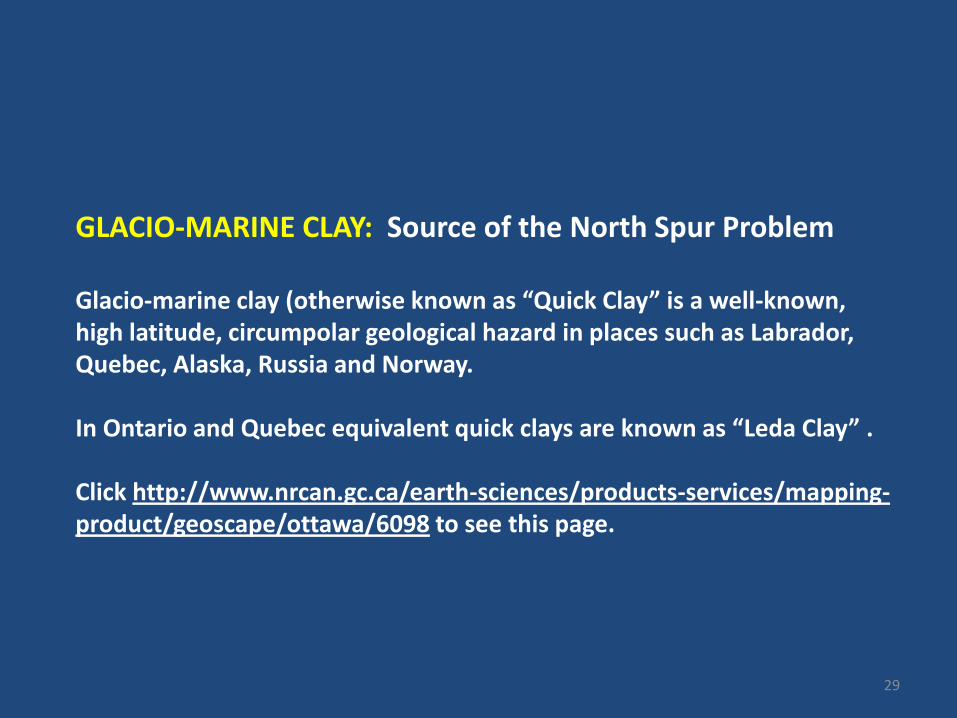
GLACIO-MARINE CLAY: Source of the North Spur Problem Glacio-marine clay (otherwise known as “Quick Clay” is a well-known, high latitude, circumpolar geological hazard in places such as Labrador, Quebec, Alaska, Russia and Norway. In Ontario and Quebec equivalent quick clays are known as “Leda Clay” . Click http://www.nrcan.gc.ca/earth-sciences/products-services/mapping-product/geoscape/ottawa/6098 to see this page.
29

After the last ice age, the whole Lower Churchill Valley was inundated by the sea up as far as Gull Island and a bit beyond. Consequently, marine clays were laid down in these areas, after which these clays were covered by more sediments as the land uplifted. The general limit of glacio-marine clays in the North Spur/ Muskrat Falls area is at 130m above sea-level (Liverman (1997)). Click http://www.nr.gov.nl.ca/nr/mines/geoscience/publications/currentresearch/1997/liverman.pdf to see this document. These “glacio-marine” clays have very peculiar properties that make them infamous as a cause of massive rapid landslides (see red triangles on next slide). As the next slide shows, landslides (“failed slope”) are common along the Lower Churchill Valley.
30

31

North Spur Soil Conditions As can be seen on the next slide, the North Spur consists largely of unstable glacio-marine clay. True bedrock is at about 230m below the current water level in the Churchill River on the upstream side of the North Spur. The sediments in the North Spur consist of four units. Measuring from the top of the Spur at elevation 50m there is: 1) An Upper Sand approximately 10 to 15m thick; 2) Followed by a Stratified Drift approx 60m thick consisting of an Upper Glacio-Marine clay deposit generally underlain with a varying thickness of sand. 3) Followed by a Lower Glacio-Marine Clay approx 50m thick . 4) Followed by a Lower Sandy “Aquifer” approx 150m thick occupying the lower part of a buried valley.
32

Dangerous Glacio-marine clays
10-15m of sand
60 m of Glacio-marine clay and sand
50m of Glacio-marine clay
150m of Sand & Gravel Aquifer
BEDROCK At 270m below top of Spur ( - 220m below sea level)
Ground elevation at Top of Spur 50 m above sea level
Present upstream river level Elev 1 m above sea level
Reservoir level after river dammed ~17m below top of Spur
Present downstream river Level ~ 1m above sea level
33

Borehole Results on the North Spur : Section C-C’ runs NS ; Section D-D’ runs E-W ( See slide 27)
34
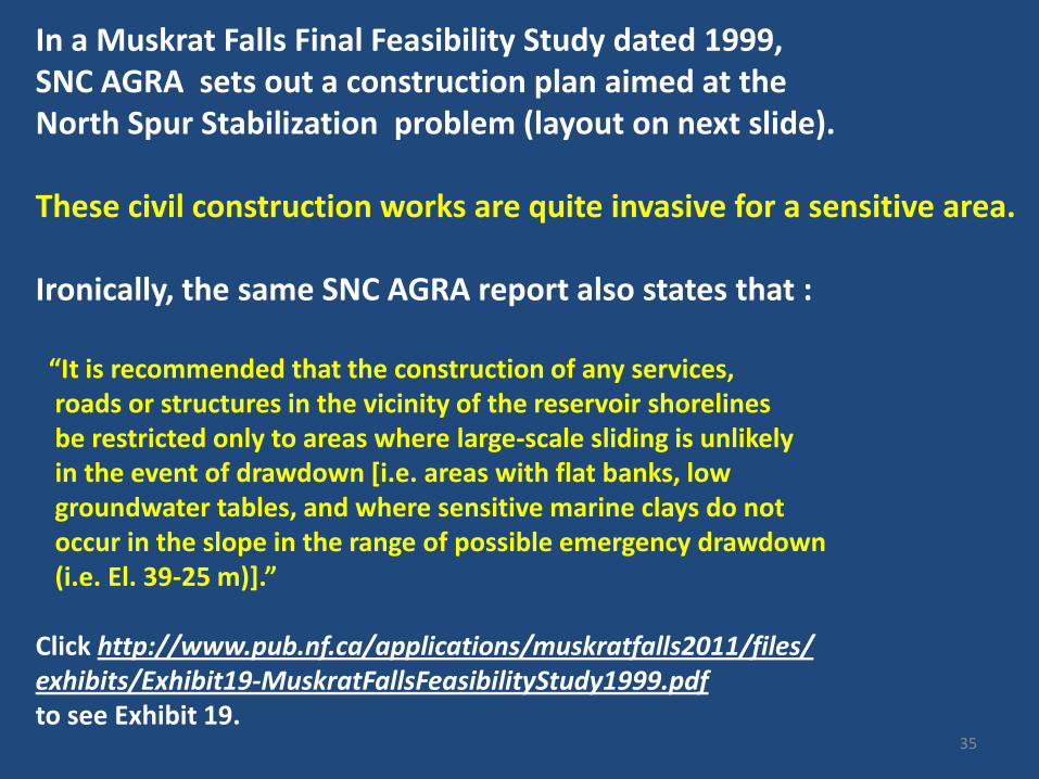
In a Muskrat Falls Final Feasibility Study dated 1999, SNC AGRA sets out a construction plan aimed at the North Spur Stabilization problem (layout on next slide). These civil construction works are quite invasive for a sensitive area. Ironically, the same SNC AGRA report also states that : “It is recommended that the construction of any services, roads or structures in the vicinity of the reservoir shorelines be restricted only to areas where large-scale sliding is unlikely in the event of drawdown [i.e. areas with flat banks, low groundwater tables, and where sensitive marine clays do not occur in the slope in the range of possible emergency drawdown (i.e. El. 39-25 m)].” Click http://www.pub.nf.ca/applications/muskratfalls2011/files/ exhibits/Exhibit19-MuskratFallsFeasibilityStudy1999.pdf to see Exhibit 19.
35

SNC- AGRA’s 1999 North Spur Plan: heavy civil works in a sensitive area
36

“b) Geotechnical • The north spur, which is an important feature of the site, provides a natural dam for development of a reservoir on the River. • Stabilization of the north spur will be required to prevent further slope failures along its upstream and downstream sides and prevent the potential loss of this important structure. The information gained from installation and operation of the interim pumpwell system since 1982 shows that control of the groundwater in the spur is the most cost-effective and reliable approach to spur stabilization. However, a combination of stabilization measures is necessary for the most effective and economical approach. Stabilization measures will require: - lowering the groundwater table in the downstream part of the spur; - provision of downstream erosion protection and downstream stabilizing fill in selected areas to improve local toe stability, and eliminate the potential for retrogressive failures due to presence of sensitive marine clays in the Upper Clay unit; - local top cutting of the spur and unloading of portions of the high steep side slopes to improve local stability; - provision of erosion protection and of a stabilizing upstream berm to prevent raveling of the upstream slopes from reservoir wave action and eliminate the potential for sliding in the unlikely (but possible) event of rapid drawdown during future project operation.”
The North Spur Stabilization Plan in 1999 SNC Final Feasibility Study was quite detailed
37

e) North Spur Stabilization It is recommended that the north spur be stabilized by: - lowering the groundwater table in the downstream part of the spur by the installation of additional pumpwells in the line of pumpwells installed in 1982, with the final pumpwell spacing selected based on the existing subsurface conditions and the performance of the existing pumpwell system; - provision of toe relief drains and a major drainage trench for further lowering of the water table; - provision of downstream erosion protection and downstream stabilizing fill in selected areas to improve local toe stability and eliminate potential for retrogressive failures due to presence of sensitive marine clays in the Upper Clay unit; - local top cutting of the spur and unloading of portions of the high, steep downstream side slopes to improve local stability; and - provision of erosion protection and a stabilizing upstream berm to prevent raveling of the upstream slopes from reservoir wave action and eliminate the potential for sliding in the unlikely (but possible) event of rapid drawdown during future project operation.
The North Spur Stabilization Plan in 1999 SNC Final Feasibility Study : 2
38

WHY ARE GLACIO–MARINE CLAYS SO DANGEROUS ? Glacio-marine clays (also called “Quick Clays”) have very peculiar properties. Most importantly, it only takes a small disturbance to turn them suddenly from a solid to a liquid.
39

Clay on the downstream side of the North Spur
40

The Rissa Video Co-incidental to the 1978 slide at the North Spur, in 1978, a quick clay landslide took place at Rissa, Norway and led to an immediate investigation and action. In 1981, an instructional video was issued by the prestigious Norwegian Geotechnical Institute which very graphically illustrates the problem – to better understand the “quick clay” problem you should view it. Click http://www.youtube.com/watch?v=3q-qfNlEP4A to see this video.
41

“Quick Clay” conditions caused the 1978 Rissa slide in Norway and in the opinion of the Geological Survey of Canada (GSC) , “quick clay“ landslide conditions are present throughout the Lower Churchill Valley.
Nalcor consultant Jacques Whitford stated that: “Although preliminary investigations suggests that the fine-grained sediments [at Muskrat Falls] are somewhat more stable than brackish-water clays in eastern Canada and elsewhere, particularly as regards their susceptibility to liquefaction, further research is required to more definitely establish the susceptibility of these materials to failure, the frequency of failure events, and the effects of water saturation and changes in fluvial activity or base resulting from reservoir formation.” Jacques Whitford Environment Limited “Sea Level History and Geomorphology of the Churchill River and Strait of Strait of Belle Isle “ (LHP98-23) December 1, 2000 “ The North Spur data base was (and remains) very poor and the problem consequently poorly defined even after all this time. And even if there are differences between the Rissa and North Spur clays, there are many key similarities.
42

Ontario and Quebec have considerable experience with “quick clay” landslides as seen in a 2008 article in the Ottawa Citizen at the link below. Click http://www.canada.com/ottawacitizen/news/story.html?id=311775e1-da21-4291-a4a2-bc0fe7ef963a to see this article.
43

Nalcor’s Bank Stability Study of June 2008 conducted by Amec discusses the issues of slope stability at the North Spur Click http://www.ceaa.gc.ca/050/documents_staticpost/26178/31993/ae2-hy-01.pdf to see this document.
44

On May 22, 2009, NRCan set out its concerns in writing regarding the deficiencies in Nalcor’s analysis of the faulting and seismic risk at Muskrat Falls. NRCan requested that Nalcor install a seismic monitoring system at Muskrat Falls. NRCan took the position that the Lower Churchill Valley has a seismic character linked in some way to the relatively seismically unstable St Lawrence Lowlands area by the regional fault system. Click http://www.ceaa-acee.gc.ca/050/documents/35087/35087E.pdf to see this document.
45

NRCan ‘s concerns came under four main headings: Natural seismic risk Reservoir Induced Seismicity (RIS) Reactivation of Regional Faults Landslide soil conditions at the North Spur
46

The Federal Provincial Joint Review Panel (JRP) in 2009 had a number of questions concerning the North Spur. For instance, it observed that : “Without an accurate understanding of the groundwater system and groundwater‐surface water interactions, the proposed dams at Gull Island and Muskrat Falls could be at risk of failure. Modelling of seepage from the reservoir to groundwater and through the dam is required together with a determination of the critical amount of seepage that would cause dam collapse. It is unclear whether groundwater will discharge into the reservoir or whether the reservoir will feed the groundwater system. It is important to document how this relationship may change.” Click http://www.ceaa-acee.gc.ca/050/documents_staticpost/26178/39444/v2-03.pdf to see page 3 of this document.
47

The Joint Review Panel (JRP) also asked NRCan to provide answers to certain question regarding faulting and seismicity at Muskrat Falls as NRCan had indicated that Nalcor had not adequately considered the potential reactivation of normal faults of the Melville Rift System which is a major fault system in the area linking back to the seismically sensitive St Lawrence Lowlands Nalcor had stated that “There is currently no evidence of seismic activity having occurred at the Lower Churchill sites in recent (geological) times.” NRCan had indicated that this comment is not warranted by the evidence presented in the EIS.
48

On October 5, 2009, Nalcor issued a study entitled: “Report on Earthquake Hazard Analysis: Gull Island and Muskrat Falls Dam sites” IR#JRP.59 October 5, 2009 This report is restricted to the application of a set of “Hard Rock” standards.
Click http://www.ceaa.gc.ca/050/documents_staticpost/26178/39444/v2-02.pdf to see this document.
49

The 2008 SNC report filed by Nalcor on October 5, 2009 sets out the restrictions on their work clearly when it said: “The seismic hazard results have been obtained for NEHRPA (Hard Rock) site conditions, as given in Table 3-1. These results apply to the Muskrat Dam site as it is founded on hard rock” However, this is true only as to the concrete, man-made part of the reservoir containment system at Muskrat Falls as they are on rock. They do not seem appropriate for North Spur soil conditions . A separate study does not seem to have been done for the North Spur using less robust numbers than for the “Hard Rock” standards. Click http://www.ceaa.gc.ca/050/documents_staticpost/26178/39444/v2-02.pdf to see this document.
50
The SNC Report further states that :
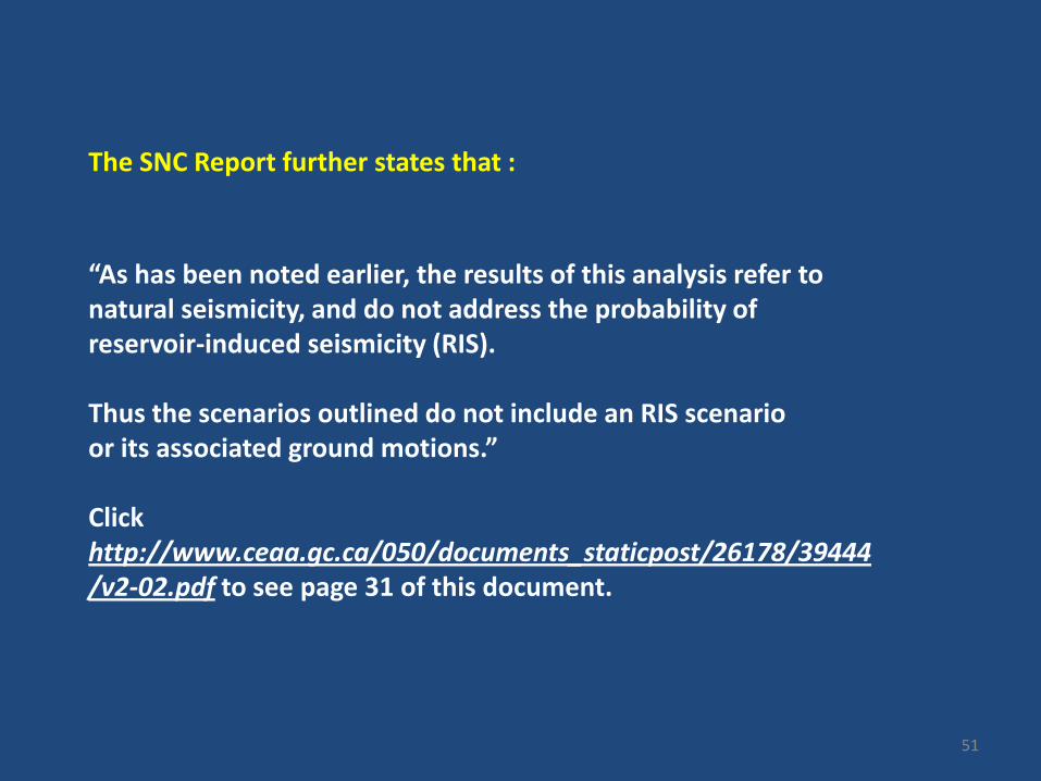
“As has been noted earlier, the results of this analysis refer to natural seismicity, and do not address the probability of reservoir-induced seismicity (RIS). Thus the scenarios outlined do not include an RIS scenario or its associated ground motions.” Click http://www.ceaa.gc.ca/050/documents_staticpost/26178/39444/v2-02.pdf to see page 31 of this document.
51
The filling of the Muskrat Reservoir may cause seismic tremors . These seismic tremors are called “reservoir induced seismicity” or “RIS” and would be in addition to normal seismic risk. RIS refers to tremors caused by the extra weight of the water in the reservoir after it is filled, for instance acting on a fault system pre-disposed to fail . In the case of quick clay, the impact of adding either groundwater pressure or RIS could disturb the delicate internal balance between the quick clay particles causing the quick clay to rapidly change from a solid to a liquid and consequently to suddenly fail.
52

On December 18th, 2009, NRCan again wrote the Lower Churchill Joint Review Panel (JRP) concerning large scale mass earth movements in relation to the Muskrat Falls Project .
Click http://www.ceaa.gc.ca/050/documents/45351/45351F.pdf to see this document.
53
In February 2010, a major landslide took place at Edwards Island, 40km upstream from Muskrat Falls
54
THE MAJOR QUICK CLAY SLIDE OF 2010 In February 2010, a major landslide took place at Edwards Island 4Okm miles upstream from Muskrat Falls. The extent of the landslide is evident in the next slide taken from a study conducted for Nalcor by AMEC in the fall of 2010. The size of the Edwards Island slide was estimated by the Geological Survey of Canada as 3.5 million cubic meters . Note that the slide has floated whole slabs of ground, with trees still upright, out into the river – a mass earth flow reminiscent of Norway’s 1978 Rissa slide.
55

View of February 2010 landslide area on south side of Churchill River upstream from Muskrat Falls caused by “Quick Clay”
56

In October and November of 2010, Amec, acting for Nalcor, conducted a drilling program on two landslide areas upriver from the North Spur – including the Edwards Island slide of February 2010. The results of this 2010 drilling program fully supported NRCan’s concerns as to the presence and character of glacio-marine clays in the Lower Churchill Valley and their direct connection to the Valley’s many landslide scars. This directed field work included the physical measurement of the glacio-marine clay characteristics that make them susceptible to liquefaction and landslide activity. Click http://www.ceaa.gc.ca/050/documents_staticpost/26178/47685/G.pdf to see this document.
57

In August, 2010, Nalcor Energy, responding to a Request for Information from the Joint Review Panel, indicated that a number of sites which show evidence of large earth flow activity would be investigated during the 2010 field season. Unfortunately, the North Spur was apparently not included in the 2010 geotechnical Program.
.
58
SNC’s 2010 Geotechnical Program was confined to the south side of the river and did not include Muskrat Falls. Click http://www.pub.nf.ca/applications/muskratfalls2011/files/exhibits/abridged/CE-19-Public.pdf to see this document.
The work by Hatch Ltd. on the North Spur in 2010 was confined to work on the pumpwell system and not to gather basic geological and engineering facts. Click http://www.pub.nf.ca/applications/MuskratFalls2011/files/exhibits/Exhibit40.pdf to see this document Click http://www.pub.nf.ca/applications/MuskratFalls2011/files/exhibits/Exhibit41.pdf to see this document.
59

On August 30, 2010, the JRP asked NRCan if it was satisfied with Nalcor’s response to NRCan concerns on seismic and landslide issues. On September 23,2010, NRCan again indicated that certain of their questions remained unanswered and that Nalcor “had not, by and large, addressed” certain faulting, seismic and landslide issues.
Click http://www.ceaa.gc.ca/050/documents/45351/45351F.pdf to see this document.
60

NRCan’s Participation in the JRP Public Meeting On March 9, 2011, NRCan gave a detailed presentation to a public hearing conducted by the Joint Review Panel in Goose Bay. As noted on the next Slide, as of March 2011, NRCan felt that Nalcor had not adequately addressed landslide issues in it’s EIS and listed a number of outstanding issues.
61

The Norwegian Geotechnical Institute stresses that glacio-marine “quick clays” are very sensitive – like a “house of cards”- and can rapidly change from a solid to a liquid. As seen in the next 4 slides, the Federal Department of Natural Resources (NRCan) emphasised these same points in their presentation to the Muskrat Falls Joint Review Panel. And NRCan also concluded that the Quick Clay problem existed at the North Spur but that Nalcor had not adequately addressed the problem in its EIS. Click http://www.ceaa.gc.ca/050/documents/48555/48555F.pdf to see the full NRCan presentation.
62

63

64

65

66
The next two slides from NRCan show many Quick Clay related landslides scattered along the Lower Churchill Valley.
67

68

69
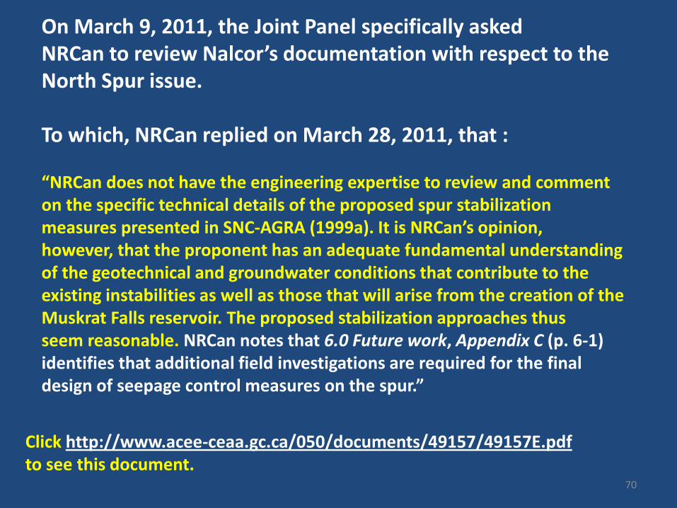
Click http://www.acee-ceaa.gc.ca/050/documents/49157/49157E.pdf to see this document.
On March 9, 2011, the Joint Panel specifically asked NRCan to review Nalcor’s documentation with respect to the North Spur issue. To which, NRCan replied on March 28, 2011, that : “NRCan does not have the engineering expertise to review and comment on the specific technical details of the proposed spur stabilization measures presented in SNC-AGRA (1999a). It is NRCan’s opinion, however, that the proponent has an adequate fundamental understanding of the geotechnical and groundwater conditions that contribute to the existing instabilities as well as those that will arise from the creation of the Muskrat Falls reservoir. The proposed stabilization approaches thus seem reasonable. NRCan notes that 6.0 Future work, Appendix C (p. 6-1) identifies that additional field investigations are required for the final design of seepage control measures on the spur.”
70

Note that NRCan was particularly interested in whether Nalcor had addressed the recommendations regarding the North Spur set out in the 1998 North Spur study conducted by Jacques Whitford Consultants for NL Hydro. See slide 5 in NRCan presentation at http://www.ceaa.gc.ca/050/documents/48555/48555F.pdf
71
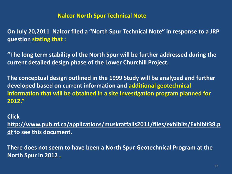
Nalcor North Spur Technical Note
On July 20,2011 Nalcor filed a “North Spur Technical Note” in response to a JRP question stating that : “The long term stability of the North Spur will be further addressed during the current detailed design phase of the Lower Churchill Project. The conceptual design outlined in the 1999 Study will be analyzed and further developed based on current information and additional geotechnical information that will be obtained in a site investigation program planned for 2012.” Click http://www.pub.nf.ca/applications/muskratfalls2011/files/exhibits/Exhibit38.pdf to see this document. There does not seem to have been a North Spur Geotechnical Program at the North Spur in 2012 .
72

The North Spur Technical Note states that: “A site investigation is also planned for 2012 to gather additional geotechnical information relating to the North Spur which will be required to complete the detailed design. The capital cost estimate for Muskrat Falls includes the work identified in the 1999 study relating to the North Spur stabilization .”
73

The Nalcor North Spur Technical Note and 3 related documents were filed with the NL PUB as Exhibit 38. Several other exhibits are also of interest : Exhibit 39 - a 122 page report dated July 2008 by Hatch Ltd. detailing groundwater monitoring activities. Exhibit 40 - a report on the pumpwell system by Hatch Ltd dated March 2010 (see in particular “2.2 Geology and Sediments”) Exhibit 41 – a report on the installation of new piezometer s in the pumpwell system by Hatch Ltd dated April 2010. Attachment B contains the geology encountered in 17 boreholes to a maximum depth of 45m. Attachment C contains a stratigraphic Xsection based on 5 boreholes to a depth of 45m over a distance of 250m showing variable geology (sand and “silty clay”).
Click http://www.pub.nf.ca/applications/muskratfalls2011/files/exhibits/ Exhibit38.pdf to see this document.
74

“The long term stability of the North Spur will be further addressed during the current detailed design phase of the Lower Churchill Project. The conceptual design outlined in the 1999 Study will be analyzed and further developed based on current information and additional geotechnical information that will be obtained in a site investigation program planned for 2012.”
The “Technical Note” stated that:
75

Nalcor’s “Technical Note” states: “Conclusions and Recommendations The dewatering system has operated continuously since November 1981 and there has been no further major landslide activity on the spur. The purpose of the installation has, therefore, been fulfilled. Rehabilitation work recommended in previous reports has been completed.”
76

In a January 2012 report to the PUB, MHI stated that “ The Final Feasibility Study [by Nalcor] included an analysis [of the North Spur] to substantiate the design concept but the detailed design studies must demonstrate the long term viability of this concept. The long term viability of this scheme is subject to further analysis and detailed design of the necessary stabilization works.” MHI went on to state that : “The consultants involved have undertaken a comprehensive review of the stability of the north spur including the response of the structure to changes in water levels. There is no reason to believe that the north spur would not be stable during the life of the project.” Click http://www.pub.nf.ca/applications/muskratfalls2011/files/mhi/MHI-Report-VolumeII-Muskrat.pdf to see page 88 of this document.
77

On December 17, 2012 Nalcor sanctioned the Muskrat Falls Project.
78
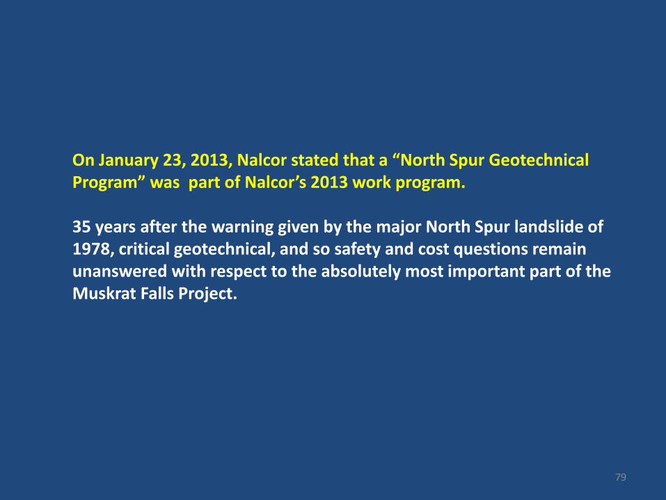
On January 23, 2013, Nalcor stated that a “North Spur Geotechnical Program” was part of Nalcor’s 2013 work program. 35 years after the warning given by the major North Spur landslide of 1978, critical geotechnical, and so safety and cost questions remain unanswered with respect to the absolutely most important part of the Muskrat Falls Project.
79

SNC Lavalin seeks Package Leader - North Spur Stabilization Team On February 6, 2013, SNC Lavalin as EPCM contractor to Nalcor posted a public notice seeking a senior engineer with far reaching responsibilities to head up a “North Spur Stabilization Project” (see next slide). The initiation of a major 2013 “North Spur Stabilization Project “ confirms that there is still a major unresolved North Spur “instability” problem . The SNC North Spur job description of February 6, 2013 clearly shows that there is still a tremendous amount of work to be done. SNC’s first task in 2013 is to collect critical North Spur field data needed to do North Spur Stabilization engineering design activities. The bottom line is that an engineering solution to the North Spur instability problem has not yet been found.
80

SNC LAVALIN JOB OPENING - posted February 6,2013
81

What is Nalcor/SNC Lavalin’s North Spur “Package Leader” going to do ?
SNC Lavalin considers a knowledge of and experience with “deep cut off walls” to be an asset for any candidate wishing to become “Package Leader - North Spur Stabilization ”. In dam building parlance, a “deep cut off wall” is a barrier impervious to water keyed into bedrock in such a way that it prevents the passage of water and forms the essential core of a man made dam of earth or concrete. It is to be hoped that Nalcor will not consider attempting to design and build essentially a massive, and extremely expensive, additional dam at the North Spur leading to enormous cost overruns. If not, we would be in unchartered waters indeed, as it would seem to indicate that the stabilization plan set out in the SNC – AGRA Final Feasibility Study of 1999 is deficient in some way and that additional , as yet unknown, tactics must be employed.
82
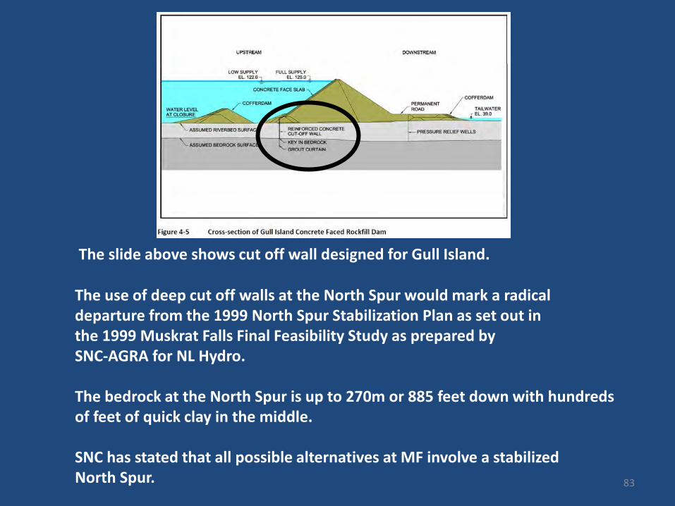
The slide above shows cut off wall designed for Gull Island. The use of deep cut off walls at the North Spur would mark a radical departure from the 1999 North Spur Stabilization Plan as set out in the 1999 Muskrat Falls Final Feasibility Study as prepared by SNC-AGRA for NL Hydro. The bedrock at the North Spur is up to 270m or 885 feet down with hundreds of feet of quick clay in the middle. SNC has stated that all possible alternatives at MF involve a stabilized North Spur. 83
How the 2013 North Spur Geotechnical Program fits in
Before the design of the new North Spur reservoir containment system can begin, Nalcor / SNC must conduct a Geotechnical Program in 2013 to acquire some very key geotechnical information. Such a program will presumably include a number of boreholes some drilled 270m to bedrock ; many of the North Spur boreholes drilled to date go to 45 to 50m which marks the top of a 50m thick “quick clay” deposit. Presumably the collection of such subsurface geological data will be followed by complex computer modelling to estimate the tendency of the North Spur to fail and the projected reasons for such failure. It is only following such modelling that the design of engineering “tactics” and physical structures to “stabilise” or effectively “replace” the North Spur can begin. It is not known if the “North Spur” geotechnical program will also include an investigation of the potentially unstable “quick clay” deposits upslope to the north towards the Trans Labrador Highway. 84

Current Situation It is accepted by all parties (including Nalcor and NRCan)
that there is a “quick clay” related instability problem at the North Spur. If the North Spur cannot be stabilized in a safe and cost effective manner, the whole Muskrat falls project will have to be cancelled. It certainly does not seem practical to excavate and remove all the glacio-marine clay at the North Spur because the clay/sand extends at least 200m below the surface of the Churchill River on the upstream side. And if it were technically possible, it would also be enormously expensive and require the construction of an additional massive 1000m long concrete or earth filled dam.
85

And there may be an additional, and possibly much larger problem, in that much larger glacio-marine quick clay slides may develop from a point upslope to the north of the Spur itself. Based on the very large scale slides that have occurred up and down the Lower Churchill Valley, this latter problem is far from theoretical.
86

General 1951 overview of Muskrat Falls looking north showing unstable ?? ground
Additional Area of Unstable Ground ?
87

North Spur
Upslope Area of Potential Instability ?
Trans Labrador Highway (TLH)
Proposed Powerhouse (red) & Spillway (white)
Manitutshu Spirit Mountain
Google Earth image of area upslope from the North Spur
88
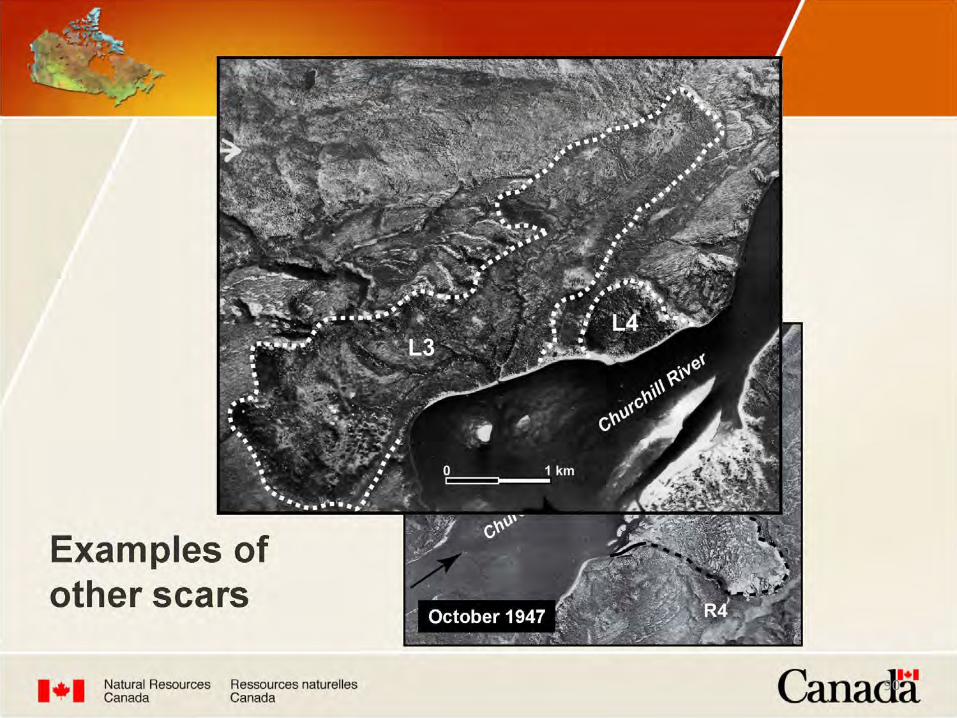
A slide involving quick clay deposits upslope from the North Spur could have an area of up to several sq km -- compared to the 0.5 sq km area of the North Spur. Norway’s Rissa slide area was approximately 0.5 sq km. The L3 slide area identified by NRCan from slide scars (next slide) is located some 40 km upstream from Muskrat Falls and had an area of 5 sq km. Discussion of the L3 slide was part of the NRCan presentation to the Muskrat Falls Joint Review Panel in March 2011 (see next slide).
89
NRCan slide on liquefaction
90

The response of the Government of Newfoundland and Labrador to the JRP Report 2011 is silent on the North Spur issue. Click http://www.cbc.ca/news/pdf/NL-response-to-enviro-panel.pdf to see this article.
And the response of the Government of Canada to the JRP Report 2011 is also silent on the North Spur issue. Click http://www.ceaa-acee.gc.ca/052/details-eng.cfm?pid=26178 to see this document.
91