the newsletter of the antinoupolis foundation fi eld projects at antinoupolis ... ical...
TRANSCRIPT
The Ne wsletter of the Antinoupolis Foundation
N u m b e r 1 - P r i v a t e l y C i r c u l a t e d - S u m m e r 2 0 1 2
President’s Note
Welcome to the fi rst newsletter of the An-tinoupolis Foundation, Inc. TAF is a 501(c)(3)not-for-profi t organization dedicated to revealing and preserving the ancient City of Antinous through archaeology, conservation and education. Th e Foun-dation fulfi ls this goal by funding specifi c targeted archaeological fi eld projects at Antinoupolis under the umbrella of the Istituto Papirologico “G. Vitelli” of the University of Florence, Italy. All TAF and Istituto projects are conducted under the direction of Dr. Rosario Pintaudi of the Istituto Papirologico and with the cooperation of the Egyptian govern-ment’s Ministry of State for Antiquities Aff airs. TAF has two periods of fi eldwork annually, and the aim of this twice-yearly newsletter is to keep friends and contributors abreast of our projects, of our goals, and of the results of our work. If you wish, you may receive ‘Th e Oracle’ automatically in electronic or paper form. Simply send us your email or address; our coordinates are at the end of this newsletter. Th ank you for your interest!
James B. Heidel, PresidentTh e Antinoupolis Foundation, Inc.
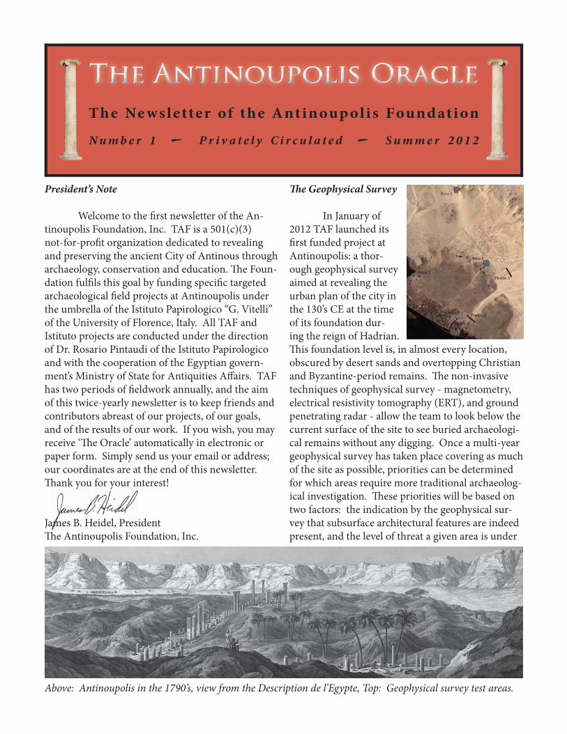
Th e Geophysical Survey
In January of 2012 TAF launched its fi rst funded project at Antinoupolis: a thor-ough geophysical survey aimed at revealing the urban plan of the city in the 130’s CE at the time of its foundation dur-ing the reign of Hadrian. Th is foundation level is, in almost every location, obscured by desert sands and overtopping Christian and Byzantine-period remains. Th e non-invasive techniques of geophysical survey - magnetometry, electrical resistivity tomography (ERT), and ground penetrating radar - allow the team to look below the current surface of the site to see buried archaeologi-cal remains without any digging. Once a multi-year geophysical survey has taken place covering as much of the site as possible, priorities can be determined for which areas require more traditional archaeolog-ical investigation. Th ese priorities will be based on two factors: the indication by the geophysical sur-vey that subsurface architectural features are indeed present, and the level of threat a given area is under
Above: Antinoupolis in the 1790’s, view from the Description de l’Egypte, Top: Geophysical survey test areas.

from encroachment by modern houses, tombs, and ag-riculture. In all such subsequent work the fi rst priority is to protect and preserve the site, and the second is to understand and publish its architectural features. Th anks to a gift from Lewis and Misty Gruber our fi rst season of geophysical survey was a one-week test season carried out in January of 2012, and it pro-duced impressive results. We laid three lines of ERT in areas of the city where we hoped to reveal underly-ing foundations of Roman urban infrastructure, and in the fi rst area we discov-ered that the apparent Nile quayside revealed in a pit next to the dig house in the 1990’s (and approximately
T h e A n t i n o u p o l i s O r a c l e - N u m b e r 0 0 1 - P a g e 2
140 meters from the current Nile edge) was indeed the ancient stone-lined Nile quay since ERT revealed no further architectural features to the west of it. Th e second ERT line was laid along the city’s cardo - its main north south street - at the point where it crosses the wadi to determine whether there are subsurface foundations for a bridge emplacement. In addition to
Th e Hippodrome. From top: View from east, ERT results, satellite image with modern cemetery at north (top) and city wall at west. Inset: our Geophys. Team, L to R, Kris Strutt, Angus Graham & Omar Farouk.
T h e A n t i n o u p o l i s O r a c l e - N u m b e r 0 0 1 - P a g e 3
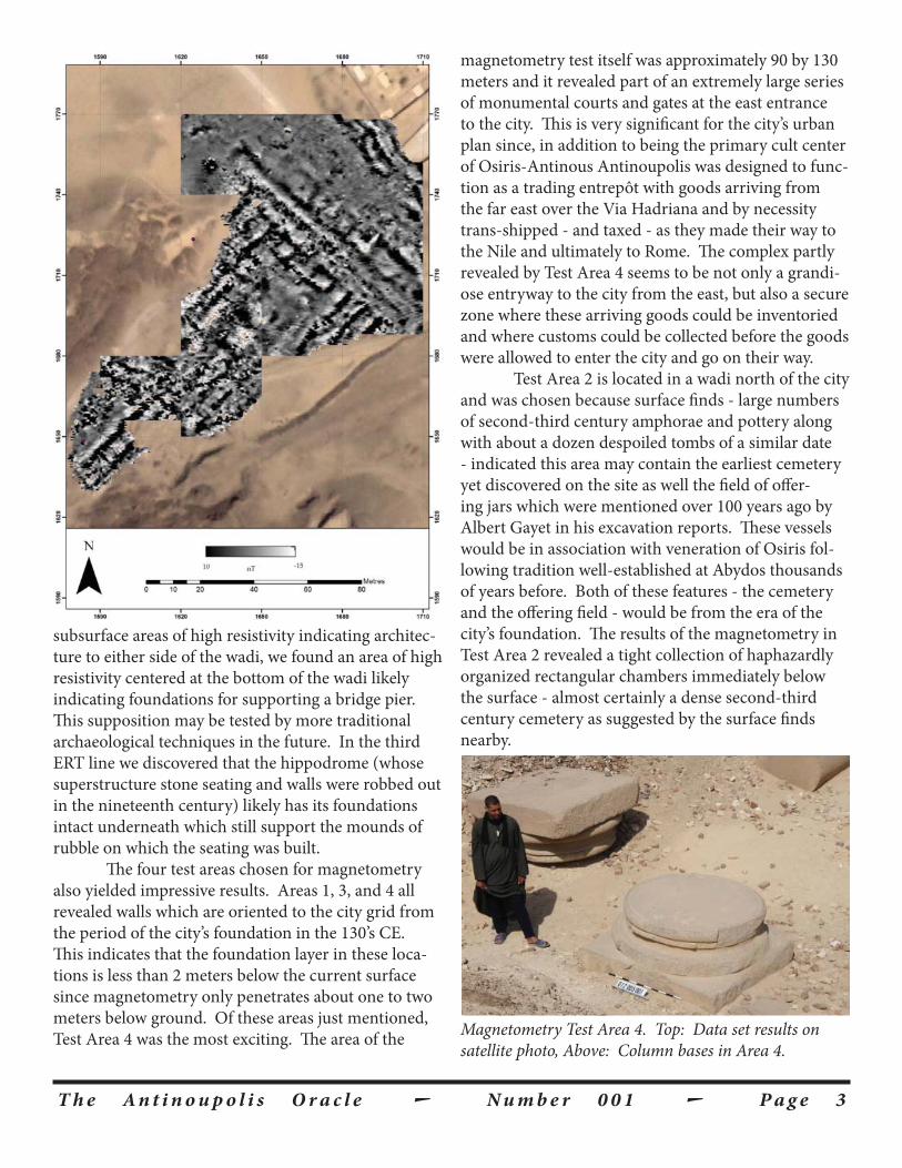
subsurface areas of high resistivity indicating architec-ture to either side of the wadi, we found an area of high resistivity centered at the bottom of the wadi likely indicating foundations for supporting a bridge pier. Th is supposition may be tested by more traditional archaeological techniques in the future. In the third ERT line we discovered that the hippodrome (whose superstructure stone seating and walls were robbed out in the nineteenth century) likely has its foundations intact underneath which still support the mounds of rubble on which the seating was built. Th e four test areas chosen for magnetometry also yielded impressive results. Areas 1, 3, and 4 all revealed walls which are oriented to the city grid from the period of the city’s foundation in the 130’s CE. Th is indicates that the foundation layer in these loca-tions is less than 2 meters below the current surface since magnetometry only penetrates about one to two meters below ground. Of these areas just mentioned, Test Area 4 was the most exciting. Th e area of the
magnetometry test itself was approximately 90 by 130 meters and it revealed part of an extremely large series of monumental courts and gates at the east entrance to the city. Th is is very signifi cant for the city’s urban plan since, in addition to being the primary cult center of Osiris-Antinous Antinoupolis was designed to func-tion as a trading entrepôt with goods arriving from the far east over the Via Hadriana and by necessity trans-shipped - and taxed - as they made their way to the Nile and ultimately to Rome. Th e complex partly revealed by Test Area 4 seems to be not only a grandi-ose entryway to the city from the east, but also a secure zone where these arriving goods could be inventoried and where customs could be collected before the goods were allowed to enter the city and go on their way. Test Area 2 is located in a wadi north of the city and was chosen because surface fi nds - large numbers of second-third century amphorae and pottery along with about a dozen despoiled tombs of a similar date - indicated this area may contain the earliest cemetery yet discovered on the site as well the fi eld of off er-ing jars which were mentioned over 100 years ago by Albert Gayet in his excavation reports. Th ese vessels would be in association with veneration of Osiris fol-lowing tradition well-established at Abydos thousands of years before. Both of these features - the cemetery and the off ering fi eld - would be from the era of the city’s foundation. Th e results of the magnetometry in Test Area 2 revealed a tight collection of haphazardly organized rectangular chambers immediately below the surface - almost certainly a dense second-third century cemetery as suggested by the surface fi nds nearby.
Magnetometry Test Area 4. Top: Data set results on satellite photo, Above: Column bases in Area 4.

T h e A n t i n o u p o l i s O r a c l e - N u m b e r 0 0 1 - P a g e 4
Aft er our successful one-week test season, TAF is currently raising funds to conduct a full-month of geophysical survey at the site during January-February 2013, and we hope to continue one-month seasons of geophysical survey for three to fi ve winters to develop a much fuller picture of the features of the city’s urban ensemble. All features disclosed by the geophysical survey will also be shared with Prof. Marcello Spanu of the University of Viterbo, Italy who is the site’s topog-rapher and who is creating a master plan of the site in AutoCAD combining and refl ecting each new dis-covery on the site made by the various teams working there, thus creating a continuously altering image of
our understanding of the city’s urban form. Th e results of the geophysical survey will also allow us to plan protection measures for the site around its edges which are currently under threat from all sides by encroach-ing agriculture, modern cemeteries, gravel and sand mining, and new - illegal - houses.
Th e Architectural Fragment Survey
An ongoing, open-ended project of TAF is an attempt to survey and collect information about the literally thousands of architectural fragments scattered across the site. Many are damaged, moved, or stolen every year, and most have never been photographed or measured. Th e aim is to create a comprehensive da-tabase with information about each fragment includ-ing material, dimensions, photographs, and drawings of any moldings or features. Each fragments is also given a positive location on the map with the use of a hand-held gps, so that even if the fragment is moved or stolen, a permanent record of what was where is avail-able for the use of scholars. Th e ultimate aim of the project is not merely a database, but also to reconstruct fragments which join - in many cases joins are appar-ent by size, material, and / or proximity - into building assemblies of colonnades and entablatures to begin to
Top: L to R, Omar, Khaled, Waleed & Kris laying out 30-meter grid squares for magnetometry. Bottom: Kris taking measurements with magnetometer in Test Area 4.

T h e A n t i n o u p o l i s O r a c l e - N u m b e r 0 0 1 - P a g e 5
make strides toward understanding the architectural vocabulary of the city even in its fragmentary state. As progress is made with the archaeology of the city, these assemblages may fi nd permanent homes for re-erec-tion on stylobates or podia revealed by future excava-tion. In addition, the locations of the fragments are supplied to the master electronic map - being prepared by Prof. Spanu - and the statistical distribution of frag-ments, their size, etc. will allow the team to begin to posit the locations of monumental building precincts versus residential quarters around the city.
A Brief History of the Site
Unlike many ancient cities, the city of Antinou-polis has a fi rm foundation date: it was founded by the Roman Emperor Hadrian on his imperial tour of Egypt in October of 130 CE. Th ere are very few earlier remains on the site, but they include a temple of about 1250 BCE from the reign of Ramses II. Th e city which Hadrian built incorporated this already ancient temple and celebrates the apotheosis of a young Greek man in Hadrian’s entourage named Antinous who drowned in the Nile nearby. Following established Egyptian custom, by drowning in the Nile Antinous became joined with Osiris, the Egyptian god of the dead, who still had an active cult in Egypt at that time. Th e city
of Antinoupolis was created to be the new god’s (the compound deity Osir-Antinous’s) cult center, and the city was lavishly endowed with elaborate monuments in both Egyptian and classical architectural styles to celebrate the new god, some of which were still extant at the turn of the eighteenth century, were documented by the French at that time, and were published by them in the Description de l’Egypte. As it turned out, Osir-Antinous may well have been the last god to be added to the ancient Egyptian pantheon, and indeed to the Greco-Roman pantheon, before Egypt and the rest of the Roman Empire was Christianized, largely in the fourth century. Antinoupolis continued to be the cult center of Osir-Antinous into at least the middle of the third century CE since the Megala Antinoeia, the Olympic-style games in honor of the god are attested until that date. Subsequently the city did not vanish, but became an active Christian center continuing well into the medieval period comprising dozens of churches and monasteries, many still visitable on the site. Early trav-ellers’ accounts from this time detail the features of the city including scores of monasteries and churches and
Top to bottom: Architectural fragment 011-020-001 reused in Church D3, the same fragment’s database page & the same fragment’s architectural drawing.

T h e A n t i n o u p o l i s O r a c l e - N u m b e r 0 0 1 - P a g e 6
many impressive Roman monuments from the era of the city’s foundation, some remaining in use. Th e city’s population fi nally suff ered a severe decline at some time in the late medieval period, and dwindled to the small Moslem village on the riverbank which exists today. Most of the ancient city has no current occupa-tion on top of it, and travel-lers’ accounts continue to tell of the impressive ruins visible above ground until the early nineteenth cen-tury, just aft er the moment of the French documenta-tion, when all of the major limestone monuments above ground were burned in lime kilns to produce quicklime (calcium oxide) for mortar to build sugar factories as Egypt joined the industrial revolution. Today the circuit of the city walls (visible as linear hills) enclose about 279 acres or about 113 hectares (Th ey form a rough trapezoid about 1.5 km by 0.75 km.), and this area is largely covered with tumbled architectural fragments and enormous mounds of pot-tery and debris. In addition to the central city within these walls, the outlying associated features are exten-sive and include cemeteries, monasteries, quarries, and other ancient remains. Th roughout the fi rst decades of the twentieth century the city’s surface was well turned and pitted both by locals looking for treasure and fertilizer from the silt-rich mud brick and by early excavators, such as Albert Gayet and J. de M. Johnson, looking for inscribed papyrus fragments and mum-mies. Th ese early eff orts were neither scientifi c, nor archaeology in the modern sense, and though some interesting bits of papyrus were recovered, the work recorded little information about the city’s inhabitants or urban form.
Top: Ramses II temple incorporated into the Hadrianic buildings of Antinoupolis. Bottom: Hypothetical recon-stuction of Hadrianic fragments reused in D3 Church.

T h e A n t i n o u p o l i s O r a c l e - N u m b e r 0 0 1 - P a g e 7
Additional Upcoming Work
In addition to the upcoming Geophysical Survey and the ongoing Fragment Survey, TAF will be conducting archaeological investigation in October / November 2012 in magnetometry Area 2 of the geo-physical test season outlined above. Th is project will be jointly funded by TAF and the Istituto Papirologico and will focus in the geophysical test area where the second - third century cemetery seems to be. Th is “ground-truthing” will allow us not only to verify the existence and extent of the cemetery, but will also al-low us to determine if the “Field of Off erings” men-tioned above is present at a deeper level than magne-tometry was able to capture.
Th e site’s longtime archaeological expedition from the Istituto Papirologico “G. Vitelli” from the University of Florence, with support from the Anti-noupolis Foundation for certain specifi c projects, seeks to redress this imbalance and to create a complete ar-chaeological picture of the ancient city and its inhabit-ants from its Hadrianic foundation to its abandonment in the medieval period.
Top to bottom: Magnetometry Test Area 2 with pro-posed work indicated, Second-third century amphora from surface of Area 2 & the Description de l’Egypte’s engraving of Antinoupolis Th eater Gate, approx. 18.5m tall.

T h e A n t i n o u p o l i s O r a c l e - N u m b e r 0 0 1 - P a g e 8
Contacting the Antinoupolis Foundation
We would love to hear from you. Our projects are conducted in coordination with the Istituto Papirologico of the University of Florence, Italy and with the kind permission of the Egyptian Ministry of State for Antiquities Aff airs for one month each January / February with a shorter follow-up season in October / November of each year. But you can always reach us by email or regular mail as shown below. And please let us know if you would like to receive future newsletters by email or regu-lar mail.
Find us on the internet –http://antinoupolis.org/
Or by email –[email protected]
Or by mail –Th e Antinoupolis Foundation, Inc.
4522 S. McDowell Ave.Chicago, IL 60609
Th e Antinoupolis Foundation, Inc. is a 501(c)(3) public charity; alldonations are tax deductable on your US federal tax return.
Th e Antinoupolis Foundation: seeking to create a complete archaeological picture of the ancient city from its founding by Hadrian as the cult center for
Osir-Antinous to its abandonment in the medieval period.
Above: the 18.75m tall triumphal arch from the Description de l’Egypte. Inset: Buried Hadrianic capital reused in D3 Church. Below: the Description de l’Egypte’s engraving of one of the city’s tetrapylon columns.