the morphology and sedimentological analyses of … · the morphology and sedimentological analyses...
TRANSCRIPT

Current Research (2005) Newfoundland and Labrador Department of Natural ResourcesGeological Survey, Report 05-1, pages 1-14
THE MORPHOLOGY AND SEDIMENTOLOGICAL ANALYSES OF ROGENMORAINES, CENTRAL AVALON PENINSULA, NEWFOUNDLAND
A. Marich, M. Batterson1 and T. BellDepartment of Geography, Memorial University of Newfoundland
ABSTRACT
This study examines the morphology and sedimentology of Rogen moraines that occupy an area of approximately 160 km2
in the central Avalon Peninsula, Newfoundland. Moraine morphology is described using a digital-elevation model created forabout 40 km2 of the study area. A preliminary review of this model indicates that there are at least three landform types pres-ent within the study area. These are, Rogen moraine, hummocky terrain, and large-scale streamlined bedforms. A distinctnortheast–southwest trend to the landscape morphology is likely a result of the underlying bedrock structure. Moraine sedi-mentology including clast fabrics, lithology, angularity and sedimentary structures are described using the available expo-sures.
It appears likely that the central Avalon Rogen moraines were formed by northeastward-flowing, warm-based ice. Thelocal sediment provenance and sedimentary structures suggest that the moraines were formed subglacially. Clast-fabric datasuggest that the sediment was re-deposited by sediment gravity flows. Further analysis and study of the digital elevationmodel, field data and air photos will be required before formative processes for the central Avalon Rogen moraine can be pro-posed.
INTRODUCTION
Rogen moraines are subglacial landforms composed ofdiscontinuous, subparallel to parallel ridges oriented trans-verse to the glacial flow (Lundqvist, 1969). Commonly, theridges are steep-sided, regularly spaced, and variably com-posed of diamicton, gravel, sand and minor amounts of siltand clay. On the Avalon Peninsula, Rogen moraines havebeen previously described by Rogerson and Tucker (1972),Sugden and John (1976) and Fisher and Shaw (1992) asoccupying about 160 km 2 of the lowland between Concep-tion Bay and St. Mary’s Bay (Figure 1). Across theProvince, Rogen and similar moraines make up about 5 per-cent of glacial landforms, occurring in patches ranging inarea from tens to hundreds of square kilometres (Figure 1).
In spite of their relatively common occurrence, the for-mation of Rogen moraines is poorly understood. Proposeddepositional mechanisms include melt-out of stacked andfolded debris layers in heavily compressed glacial ice(Shaw, 1979; Bouchard, 1989) and infilling of ripple-shapedcavities formed at the glacier bed by large meltwater dis-
charges (Shaw, 1983, 2002). Although the various mecha-nisms for the formation of Rogen moraines are discussedlater, the depositional history of the moraine has importantimplications for i) ice-flow history of the study area and gla-cial dynamics, ii) aggregate potential, and iii) sedimentprovenance and drift prospecting.
The main objective of this study is to determine the gla-cial depositional process(es) that formed the Rogenmoraines of the central Avalon Peninsula by sedimentologi-cal examination and through a morphological descriptionusing a Digital Elevation Model (DEM) and air photos.
REVIEWDescription
Lundqvist (1969) applied the name “Rogen” moraine tothe moraine he examined near Lake Rogen, Sweden. Theyare found in groups that occupy a few dozen to several hun-dred square kilometres within regional basins or troughs,generally away from predicted ice-dispersal centres. Indi-vidual moraines vary in morphology but most are 5 to 25 m
1
1 Geological Survey, Newfoundland and Labrador Department of Natural Resources

CURRENT RESEARCH, REPORT 05-1
2
Figure 1. Study area, indicating location of places mentioned in the text, the location of study sites, Rogen moraine ridge ori-entations, clast-fabric girdle mean directions and relevant striation data. Also note the location of the two digital elevationmodels (A and B) shown as lettered boxes. Inset shows location of places mentioned in the text outside of the Island of New-foundland, and also locations of other Rogen moraines in Newfoundland and Labrador.

A. MARICH, M. BATTERSON AND T. BELL
high, 100 to 450 m wide and 0.5 km to 5 km long and aresinuous and sometimes anastomosing, evenly spaced, usual-ly at distances similar to their widths; the intervening areastend to be occupied by ponds or bogs, concealing the baseof the ridges (Plates 1, 2 and 3). This regular pattern ofmoraines, ponds and bogs is easily recognizable on aerialphotographs (Plate 1). Similar features have been describedby Hughes (1964) as “ribbed moraine” due to a shape simi-lar to fish scales or ribs. The ridges are commonly composedof poorly sorted diamicton and show various sedimentarystructures (including sorted sands and gravels, convolutedbedding, small faults and lenses) (Lundqvist, 1969, 1989;Shaw, 1979; Bouchard, 1989; Fisher and Shaw, 1992;Hättestrand, 1997).
Rogen moraines are part of a sediment-landform asso-ciation that is characterized by a continuum of intraglaciallandforms (Figure 2; Lundqvist, 1969). The Rogen morainecomponent forms in areas of slow, compressive flow over aconcave glacial bed, whereas drumlins form in areas offaster moving ice undergoing extension, above a convexglacier bed (Burgess and Shaw, 2003).
Rogen (ribbed) moraines are common to many regionsof Newfoundland and Labrador (Figure 1) and they occupybroad topographic depressions or troughs (Ives, 1956; Hen-derson, 1959; Hughes, 1964). Individual tracts of thesemoraines commonly consist of arcuate, sinuous ridges thatrange in height from 10 to 30 m and are spaced 20 to 200 mapart (Ives, 1956; Henderson, 1959, 1972; Rogerson andTucker, 1972; Bouchard, 1989; Fisher and Shaw, 1992; Bat-terson and Taylor, 2004). Studies in Labrador, near Schef-ferville (Ives, 1956; Henderson, 1959) report a scattering ofboulders on Rogen moraine surfaces, and steeper proximalslopes on ridges.
Rogen Moraine Formation
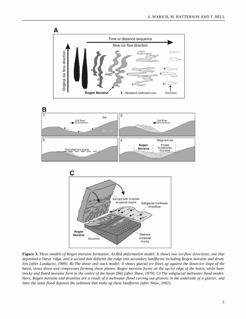
There are three common depositional models for Rogenmoraine formation (Figure 3). These are; the bed-deforma-tion model that requires a change in ice-flow direction andsubglacial deformation; the shear and stack model that relieson compressive flow and ice stagnation; and the subglacialmeltwater model that requires a massive subglacial flood ofmeltwater and subsequent glaciofluvial infilling.
The bed-deformation model suggests that Rogenmoraines are a precursor to the drumlinization of transverseridges (Boulton, 1982; Figure 3A). There are two require-ments for this model; landforms produced by a previous gla-cial event must possess alternating sections of weak andresistant sediment, and there must be a change in glacial-flow direction. The change in ice-flow direction leads to the
reworking of the previously deposited sediment, moving theweak sediment down ice, and leaving the more resistantones behind (Boulton, 1982). Lundqvist (1989) used thismodel to explain the formation of Rogen moraine near LakeRogen, Sweden.
In contrast, the shear and stack model, which Bouchard(1989) proposed for Rogen moraines in western Labrador,suggests that they formed as ice is compressed up againstthe down-ice margin of a basin, forming shear planes andstacked slices of debris-rich ice (Figure 3B). Following gla-cier stagnation, the englacial sediment is lowered to the bedto form linear debris ridges.
3
Plate 1. Air photos of Rogen moraines on the central Aval-on Peninsula. Note that the Rogen moraine ridges are lin-ear, parallel to one another, evenly spaced, and ponds orbogs commonly occupy troughs between ridges.
Plate 2. Oblique aerial view of Rogen moraines near OceanPond, looking south across the Trans-Canada Highway.Note the presence of ponds between the Rogen moraine.
TCH
N

CURRENT RESEARCH, REPORT 05-1
In a third model, the formation is attributed to cata-
strophic subglacial floodwaters moving through a basin(Shaw, 1983, 2002; Figure 3C). The flood erodes grooves onthe underside of the thickest ice in the centre of the basin.Rogen moraines are deposited in these grooves as the flood-waters wane and deposition occurs. The overlying ice even-tually stagnates. Fisher and Shaw (1992) invoked this thirdhypothesis for the formation of Rogen moraines on the Aval-on Peninsula. They cited two observations as evidence forthis mode of formation, including sedimentary evidence ofdebris flows and fluvial deposits within ridges.
STUDY AREA
The central Avalon Rogen moraine field occupies abroad lowland between Conception Bay, St. Mary's Bay, theHawke Hills (highest elevation at 244 m) and rolling hills(highest elevation at Spread Eagle Peak, 275 m) west ofWhitbourne. The basin floor lies about 180 m asl (Figure 1).The lowland occupies the Trinity Bay Synclinorium, a broadsyncline that lies between the Conception Bay Anticlinori-um that forms the Hawke Hills to the east, and the SpreadEagle Thrust that forms hills to the west (King, 1988).
The study area is located in the Avalon technostrati-
4
Plate 3. Photograph looking southeast showing Rogen moraine ridges extending into Middle Gull Pond.
Figure 2. Diagrammatic representation of the landformcontinuum of subglacial landforms. Rogen moraine forms inareas of slow, compressive flow over a concave glacial bed.Drumlins form in areas of faster moving ice undergoingextension, above a convex glacial bed (after Burgess andShaw, 2003).
A. MARICH, M. BATTERSON AND T. BELL
5
Figure 3. Three models of Rogen moraine formation. A) Bed deformation model: It shows two ice-flow directions; one thatdeposited a linear ridge, and a second that deforms the ridge into secondary landforms including Rogen moraine and drum-lins (after Lundqvist, 1989). B) The shear and stack model: It shows glacial ice flows up against the down-ice slope of thebasin, slows down and compresses forming shear planes. Rogen moraine forms on the up-ice edge of the basin, while hum-mocky and fluted moraine form in the centre of the basin (B4) (after Shaw, 1979). C) The subglacial meltwater flood model:Here, Rogen moraine and drumlins are a result of a meltwater flood carving out grooves in the underside of a glacier, andlater the same flood deposits the sediment that make up these landforms (after Shaw, 2002).

CURRENT RESEARCH, REPORT 05-1
graphic zone (Colman-Sadd et al., 1990). Bedrock consistsof late Precambrian and Palaeozoic sedimentary andigneous rocks (King, 1988). The oldest rocks are theHadrynian Harbour Main Group that consist of felsic vol-canic, rhyolite, balsaltic flows, and pyroclastic rocks. TheHarbour Main Group extends along the eastern edge of theRogen moraine field and is fault bounded at the Peak PondFault, south of the Avalon Wilderness Reserve. This group isoverlain by the Drook and Mistaken Point formations thatconsist of tuffaceous siltstone and sandstones of the Con-ception Group. The youngest rocks are from the St. John’sGroup and include thinly bedded, graded sandstones andminor tuffaceous rocks of the Trepassey Formation (King,1988).
There is a distinct northeast–southwest lineation to thetopography of the central Avalon Peninsula, reflecting thestructure and differential resistance of the underlyingbedrock. Multiple ridges and troughs are oriented in thisdirection. The Rogen moraines tend to occupy the troughs,and are oriented perpendicular to the trough long axis (Fig-ure 4). River valleys, such as that occupied by the SalmonierRiver, also follow this structural control.
GLACIAL HISTORY
Evidence of glaciation on the Avalon Peninsula duringthe late Wisconsinan is widespread. Catto (1998) has identi-fied three phases; initial glaciation, glacial maximum anddeglaciation. Initial glaciation was marked by the develop-ment of several ice-dispersal centres. Ice flowed radially outof these centres and in several places two or more centrescoalesced with one another. The lack of erratics from thecentre of the island has been used to suggest that the AvalonPeninsula supported its own independent ice cap (Catto,1998). During the glacial maximum, ice covered the entireAvalon Peninsula. A lowering of global sea level allowedthe development of the extensive ice-dispersal centre overSt. Mary’s Bay (Henderson, 1972; Rogerson and Tucker,1972; Catto, 1998). This ice-dispersal centre dominated theAvalon Peninsula with the predominant ice-flow directionbeing generally northward into Conception and Trinity bays.This flow direction has been recorded in the orientation ofthe Rogen moraine of the central Avalon Peninsula.Deglaciation was accompanied by a rise in sea level, lead-ing to instability of the St. Mary’s Bay ice cap, and its even-tual break up. Small ice caps likely persisted along uplandridges of the major peninsulas for some time after collapseof the St. Mary’s Bay ice cap. The final deglaciation of theAvalon Peninsula occurred by 10 ka BP, based on the oldestbasal radiocarbon date from Golden Eye Pond in the HawkeHills (Macpherson, 1996).
METHODS
FIELD WORK
Field data were collected during an eight-week periodbetween June and August 2004. The internal composition ofthe Rogen moraine ridges has been recorded at 26 expo-sures, and surface pits were dug to depths of 1 m. Naturalexposures were rare and mainly occurred along logging andcabin roads. They ranged in height from 3 to 16 m but mostwere between 5 and 8 m high. Typically, they cut throughridge crests in gravel pits or road exposures. As logging isactive in the area and cabin development ongoing, all roads,whether paved or gravel, were driven or walked in a searchfor sediment exposures. Standard stratigraphic and sedimen-tological observations were made following the proceduresand standards of Krumbein (1939), Hart (1994), Benn andEvans (1998), Allen (1999) and Larsen and Piotrowski(2003). Sediment observations included sediment texture,compactness, stoniness, colour, clast lithology, and clastfabric. The presence or absence of striated clasts was alsonoted. Exposed bedrock was extremely rare in the studyarea, but where observed, it was examined for the presenceof striations.
DATA ANALYSIS
Digital Elevation Model Production
Digital elevation models (DEMs) were created for thisstudy from digital topographic maps at scales of 1:5000 and1:2500. A total of 59 map sheets were converted to DEMscovering an area of approximately 40 km2 in the northeastcorner of the study area. The DEM was created usingArcMap’s 3-D Analyst extension. A triangulated irregularnetwork (TIN) of elevation points (Kumler, 1994) was usedto model the continuous landscape surface of the map area.A large amount of virtual memory is required to draw thesemodels within ArcMap; therefore the TINs were convertedto a raster dataset and viewed within ArcGIS 8.3. Some ele-vation errors are assumed because the shapefiles obtainedwere digitized versions of contour maps created using pho-togrammetry. Errors may have been produced in the transferof data from analogue to digital format. Slight alterations inthe locations of the contour lines and spot heights areexpected. Also, errors occur in the production of the TIN,when the computer calculates the area and location of theelevation triangles. Artificial flat areas, where patches of theland surface are assigned the same elevation value, are com-mon. The resolution of this digital elevation model is there-fore compromised to some degree both horizontally and ver-
6

7
A. MARICH, M. BATTERSON AND T. BELL
7
Figure 4. A) This digital elevation model (DEM) shows well-developed Rogen moraines near Hodgewater Pond. Note theseries of parallel ridges within the localized troughs. B) Digital elevation model of Rogen moraines near Mahers. Note thetransition from easily recognizable Rogen moraines in a trough up into hummocky terrain at the top of the slope. Note thatthe scale of these models is not uniform, and vertical exaggeration is approximately 10 times.

CURRENT RESEARCH, REPORT 05-1
tically. The cell size resolution of these models is between 5and 10 m.
PRELIMINARY OBSERVATIONS
Geomorphology
Preliminary visual interpretation of the DEM (Figure 4)and air photographs has led to the classification of three dis-tinct landform types: Rogen moraine, hummocky terrain andstreamlined bedforms. Further analysis of the DEM will benecessary to generate morphometric descriptions of theseindividual landform types.
Rogen Moraine
Rogen moraine commonly occurs in northeast–south-west-trending linear troughs (Figure 4). Generally themoraines are oriented perpendicular to the troughs, and are0.5 to 5 km long, 35 to 250 m wide and 5 to 30 m high. Indi-vidual ridges are spaced between 200 and 320 m apart, andponds or bogs commonly occupy the depressions betweenthem (Plate 1). At least two forms of Rogen moraines areobserved in the DEM, which occupy approximately 20 per-cent of the area covered by the DEM. An example of the firstis located in the area surrounding Ocean Pond and is com-posed of well-developed moraine ridges that are continuous,evenly spaced, and oriented parallel to one another. Theyform relatively small patches, no larger than 5 km2, betweenareas of streamlined bedforms and hummocky moraine. Incontrast, the second form of Rogen moraine are highly dis-sected, discontinuous, and unevenly spaced ridges thatmostly occur in the southeast part of the DEM where theycover an area greater than 10 km2.
Hummocky Terrain
Hummocky terrain covers about 20 percent of theDEM, and consists of a series of randomly oriented ridgesand knobs. Based on visual interpretation of the DEM, thesefeatures range from 50 to 90 m wide, 100 to 300 m long, andare commonly located on ridges between tracts of Rogenmoraine.
Large-scale Streamlined Bedforms
Streamlined bedforms are prominent features in thenortheast corner of the DEM. These bedrock structures arelinear features trending northeast–southwest, and they aregenerally wider at the northeast end. These landforms rangefrom 600 to 3000 m wide, range between 25 and 100 m highabove the surrounding landscape, and are generally between2 and 7 km long.
Landform Transitions
There are two types of transitions from Rogen morainesto other landforms. First, there is a gradual lateral transition
from the Rogen moraine in the troughs to hummocky terrainsituated on top of the bedrock ridges, where the hummockyterrain is an extension of the Rogen moraine. At the margins,individual hummocks are spaced farther apart than theRogen moraine ridges, their heights are more subdued, andthey are shorter in length, more sinuous and randomlyarranged (Figure 4). The second transition is abrupt, occursat the ends rather than the sides of the Rogen moraine-occu-pied troughs. The moraines are confined to troughs, becom-ing less common as elevation increases out of the troughs,normally at the base of a streamlined bedform.
INTERNAL COMPOSITION
Sediment Characteristics
Twenty-six exposures were logged, 13 through Rogenmoraine and 10 through hummocky terrain. There is noapparent difference in sediment exposed in the two terraintypes and therefore separate descriptions are not necessary.Excavations along the sides and near the crests of ridges typ-ically revealed a relatively consistent exposure of olive grey(5Y6/1) poorly structured, relatively compact diamictonwith a silty sand matrix (Plate 4). Stone content varies fromabout 25 to 80 percent, and clast diameter ranges betweenseveral centimetres and a few metres, but averages around10 cm. Faceted clasts are found at 70 percent of the sites.Clasts were exclusively local sedimentary rocks. Some sort-ed sediments form normally graded to massive openworklenses of gravel and coarse sand that are preferentially locat-ed underneath large clasts. The lens shape tends to mirrorthe underside of the clast, whereas lens thickness shows aproportional relationship with clast diameter, varyingbetween a few millimetres and >10 cm thick.
Boulder lines or rows were observed at 10 percent ofthe exposures, commonly comprising similar-sized clasts
8
Plate 4. A typical exposure within Rogen moraine, showingnon-sorted, massive diamicton, with a silty sand matrix. Theheight of this exposure is approximately 80 cm.

A. MARICH, M. BATTERSON AND T. BELL
and one clast thick, and underlain by openwork gravel lens-es that extend the length of the line. Boulder lines and clastsare capped by silt, the thickness of which increases propor-tionally with the size of the underlying clast, varying from afew mm to 5 cm thick. In places, thin layers of sand overlythe silt. Diamicton exposures also contain inclusions of clayand silty clay, between 5 and 15 cm in diameter, and theinclusions may contain coarse gravel.
At 6 of the 26 exposures, two different diamicton unitswere defined, distinguished mostly on the basis of matrixtexture, stoniness, and the occurrence of gravel lenses, e.g.,Site 4, northeast of Hawcos Pond (Figure 5). Four of the 6exposures were located in Rogen moraines, and two in hum-
mocky terrain. The upper of the two diamictons resembledthe single diamicton observed at the other 20 sites(described previously). The lower diamicton was supportedby a sandy silt matrix, clasts were predominantly subangu-lar and of local provenance, and the percent stoniness wasless than the upper diamicton, but was still greater than 50percent. There appeared to be less openwork gravel lensesassociated with the lower diamicton; however, silt caps werecommon.
Clast Fabrics
Clast fabric data from stony diamictons may be difficultto interpret. Clast interaction during deposition of stony
9
Figure 5. Sedimentary log for the exposure at Site 4. The profile shows the upper and lower diamictons, and a weak girdlefabric typical of the Avalon Rogen moraines. The photograph shows an openwork lens between two clasts, and a silt cap wherea clast was removed, directly above the scale bar (in centimetres).

CURRENT RESEARCH, REPORT 05-1
diamicton is common, and therefore the orientation of indi-vidual clasts represent those interactions rather than thedirection of ice flow in tills or slope aspect in gravity flowdeposits (e.g., Benn and Evans, 1998). This may explain thewithin-site variability of clast fabric data (Figure 6). Also,clast lithology influences fabric measurements. Localbedrock of the central Avalon Peninsula produce clasts thateasily break along fractures and bedding planes, thus elon-gated clast shards tend to develop. Measurement of theseclasts may be problematic in that the clast orientation maynot necessarily represent ice flow, but the fracture plane ofthe clast.
A total of 57 clast fabrics (25 clasts each with alength–breadth ratio of at least 3:2) were measured ondiamicton exposures. A minimum of two fabrics were meas-ured at each site, in different faces where possible, and inboth diamictons where observed. Statistics expressing theshape and strength of the clast fabrics were calculated usingGeorient 32 v 9 following the methods of Woodcock (1977).Eigen vectors (V1, V2, V3) show the direction where maxi-mum clustering of clast orientations occurs, as well as theplanes perpendicular to the preferred fabric orientation,whereas Eigen values (S1, S2, S3) describe the degree of clus-tering around Eigen vectors. The fabric strength parameteris C, (C = Ln(S1/S2)) and is considered weak when <1 andstrong when >3 (Woodcock, 1977). The shape parameter isK, (K = Ln(S1/S2)/Ln (S2/S3) and clusters occur when K>1and girdles when K<1. Clusters have a narrow range of dipand direction values, whereas girdles show a broad range indirection values, and a narrow range of dip values (Wood-cock, 1977).
Based on their S1 and K values, 12 fabrics from 11 siteshave moderately strong clusters (S1 values 0.61- 0.92, K val-ues 1.18 to 3.72) indicative of ice-flow direction in primarytills (Dowdeswell and Sharp, 1986; Hart, 1994; Hart andRoberts, 1994). An S1 value of 0.6 was used to filter the clastfabric results in order to easily distinguish between thosefabrics that fall within the range of values considered to bemoderately strong clusters. Half of these fabrics display amean direction in the northeast quadrant, the other half aredistributed throughout the other three quadrants. When com-pared to nearby striation data, 3 sites show close correspon-dence between fabric and striation direction, while theremaining 9 fabrics deviated from striations by 20° to 70°.Most of the fabrics show ice flow oblique to ridge orienta-tion. The 12 fabrics generally have steeply dipping clasts,with a mean dip angle of 53°.
The remaining 45 fabrics have weak to strong clustersand girdle shapes (Figure 7) (S1 values 0.40-0.80, K values
0.15 - 6.06). The mean azimuth for these fabrics rangesbetween 16° and 307°, whereas the mean plunge is consis-tently steep at 41° to 79°. About 40 percent of these fabricshave mean directions roughly parallel to the ridge crestsfrom which they were measured; the remainder wereoblique.
10
Figure 6. A scattergram showing S1 values for paired clastfabrics measured at a single site, and S1 values from fabricpairs measured from two diamictons at the same site. Notethe inconsistency of results, which is likely a result of thevariance in stoniness within the diamictons and/or the depo-sitional processes.
Figure 7. Shapes of clast fabrics from diamictons withinlandforms of the central Avalon Peninsula. Note that thefabrics measured within the Avalon Rogen moraine areweak clusters or girdles.

A. MARICH, M. BATTERSON AND T. BELL
A plot of S1 against S3 values for each of the 57 fabricssuggests that most are similar to fabrics measured from sed-iment gravity flow or deformation till deposits (Figure 8).There was no distinct difference between fabric data meas-ured in sites from Rogen moraine (n= 27) or hummocky ter-rain (n=23), with less than 30 percent in each having S1 val-ues >0.6. Similarly, a comparison of fabrics from sites withmultiple diamictons showed no marked difference betweenS1 value strength (0.52 vs. 0.58 for lower vs. upper) androughly 70 percent of fabrics in both diamictons plot in thesediment gravity-flow envelope of Figure 8.
DISCUSSION
The Rogen moraines of the Avalon Peninsula show sim-ilar morphometric and sedimentological characteristics toexamples of Rogen moraines described elsewhere(Lundqvist, 1969, 1989; Shaw, 1979; Bouchard, 1989, 1992;Hättestrand, 1997). The Avalon Peninsula Rogen morainefield also occupies a similar topographic setting to theseother examples. Also, a similar landform transition has beenobserved on the Avalon Peninsula, although a transition todrumlins does not occur.
The local origin of the sediment within the Avalonmoraines implies a short transport distance, a characteristicof sediment transported subglacially by warm-based ice(e.g., Bennett and Glasser, 1996). Other evidence of sub-glacial transport are faceted clasts, and bimodal or multi-modal grain-size distributions (Boulton, 1978; Benn andBalantyne, 1994). Faceting has been observed in 70 percentof the sediments within the Avalon moraines, but the grain-size analysis has yet to be completed, therefore it is tenta-tively suggested that these sediments were deposited sub-glacially by warm-based ice.
There were few sedimentary structures found within themoraines and they are not diagnostic of a particular deposi-tional environment. The openwork gravel lenses that wereobserved in the Avalon Peninsula moraines are similar tothose described by Shaw (1982a), who linked these struc-tures to the melting out of till from stagnating ice. However,Fisher (1989) described similar features, which he interpret-ed as the result of winnowing of fines during turbulence pro-duced by subglacial fluvial erosion. Boulder lines or rowsoccur in 10 percent of the sites. These structures are com-monly assigned a lodgement origin (c.f., Dreimanis, 1989)although Hiscock (1991) suggests a range of potential form-ative processes, including deformation, melt out and sedi-ment-gravity flows. Differentiation of these processes willrequire further work on pavement clast fabric and morphol-ogy. Silt caps or clasts may be interpreted in one of twoways; as draped beds comparable to those observed withinthe Sveg tills of central Sweden (Shaw, 1979, 1982b) pro-
duced by the direct meltout of debris-rich ice onto underly-ing clasts, or the result of downward percolation of meltwa-ter during the Holocene. No clear evidence was found tosupport one interpretation over the other.
Clast-fabric measurements as discussed previously arenot diagnostic of depositional process, although they may beused along with sedimentological evidence to suggest adepositional environment. The large number of clast fabricsfalling within the sediment gravity-flow envelope suggeststhat this may be a process involved in the deposition of theAvalon Peninsula Rogen moraine. Common structures asso-ciated with sediment gravity flows include elevated “float-ing” clasts, reverse grading, crude laminations, patches ofmud matrix, and washed lenses of silt, sand, or gravel. Sed-iment gravity flows are generally clast- to matrix-supported,contacts between sediment types are commonly sharp andslightly erosive, and clast fabrics are disorganized (Nemec,1990; Benn and Evans, 1998). The sediments of the AvalonPeninsula Rogen moraines commonly exhibit washed lens-es of gravel and coarse sand, and the blocky silt and/or clayinclusions are similar to the patches of mud matrix describedby Nemec (1990).
Three models for Rogen moraine formation aredescribed. Currently, based upon the studies undertaken sofar, there is insufficient evidence to accept or reject any ofthese models for the formation of the Avalon Rogenmoraine. The bed deformation model requires that previous-ly deposited landforms be remoulded by a subsequent iceflow perpendicular to the flow that deposited them, there-fore evidence of subglacial deformation would be expected
11
Figure 8. Plot of S1 versus S3 Eigen values from diamictonswithin the central Avalon Peninsula. Envelopes for differ-ent depositional environments have been drawn (afterDowdeswell et al., 1985 and Batterson, 2003). Most of thefabrics measured in this study fit within the sediment gravi-ty-flow envelope.

CURRENT RESEARCH, REPORT 05-1
(Boulton, 1982); evidence of subglacial deformation struc-tures were not observed in this study. The shear and stackmodel of Rogen moraine formation, largely throughmeltout, is suggested by the presence of silt caps and open-work gravel lenses found within exposures. Similarly, mostof the clast fabrics measured within these sediments fallwithin the sediment gravity flow and melt-out till envelopes.These characteristics might come through shearing andstacking of glacial ice, followed by in situ melting. The sub-glacial meltwater model cannot be rejected. The presence ofsorted lenses suggests the presence of water during forma-tion, although the lack of glaciofluvial sediments to supporta depositional mechanism or a surface lag of boulders ortruncation of beds to support an erosional mechanism mayargue against this model, but further analysis of the sedi-mentological and morphological data is required to eitheraccept or reject this model.
CONCLUSIONS
The orientation of the Rogen moraine ridges asobserved within the DEM, coupled with limited clast fabricand striation data, indicate the moraines were formed bynortheastward-flowing ice. This preliminary work concern-ing the genesis of the Avalon Peninsula Rogen moraine hasconcluded that several mechanisms may be involved in theirgenesis. It is apparent, based on the observation of open-work gravel lenses and silt caps that water was involved atsome stage in the formation of the Rogen moraine. The localorigin of the sediments within the Rogen moraine ridges andinferred short transport distances suggest that the sedimentwas transported and deposited subglacially. It is also impor-tant to note the similarity between Rogen moraine and hum-mocky terrain internal composition. Based on their internalcomposition it is not possible to distinguish between Rogenmoraine and hummocky terrain, therefore it is likely thatthese landforms were developed under the same conditionsand within the same glacial event.
FUTURE WORK
Further work for this project will include an in-depthanalysis of the digital elevation models, aerial photography,and internal composition of the Avalon Rogen moraines, asa means of understanding the external morphology, forma-tive processes, and timing of the Avalon Rogen morainegenesis. It is anticipated that further analysis of the digitalelevation models will enable a clear differentiation betweenRogen moraine, hummocky terrain, the streamlined bed-forms and the unclassified terrain, as well as any other typeof landform that may be present in the central Avalon Penin-sula.
ACKNOWLEDGMENTS
Project funding was provided by a Natural Sciences andEngineering Research Council (NSERC) grant to TrevorBell. Field assistance was funded through the HumanResources and Skills Development Canada Summer CareerPlacement Program. Andrea Marich acknowledges a Memo-rial University of Newfoundland fellowship. Christa Quilty,Heather Hickman, Stacy Campbell, Mariana Trindade, Jen-nifer Bose, and Tim Hollis, all with the Department ofGeography, Memorial University of Newfoundland, assistedwith field work. Jeff Wood, Surveys and Mapping Division,Department of Environment and Conservation, provided thedigital data for the DEM, while Larry Nolan and Dave Tay-lor, Geochemistry, Geophysics, and Terrain Sciences Sec-tion, Department of Natural Resources, provided additionaldigital data. We would like to acknowledge the privatelandowners who allowed us access to their properties. Final-ly, thanks to David Liverman and Shirley McCuaig for theirhelpful reviews of the manuscript.
REFERENCES
Allen, T.1999: Particle Size Measurement. 4th edition, Chapmanand Hall, London, 806 pages.
Batterson, M.J.2003: Quaternary geography and sedimentology of theHumber River Basin and adjacent areas. NewfoundlandDepartment of Mines and Energy, Geological Survey,Report 03-02, 194 pages.
Batterson, M.J. and Taylor, D.M.2004: Regional till geochemistry and surficial geologyof the central Avalon and Bay de Verde peninsulas. InCurrent Research. Newfoundland Department of Minesand Energy, Geological Survey, Report 04-1, pages 93-106.
Benn, D.I. and Balantyne, C.K.1994: Reconstructing the transport history of glacigenicsediments: a new approach based on co-variance ofclast rorm indices. Sedimentary Geology, Volume 91,pages 215-227.
Benn, D.I. and Evans, D.J.A.1998: Glaciers and Glaciation. Oxford University Press,London, 734 pages.
12

A. MARICH, M. BATTERSON AND T. BELL
Bennett, M.R. and Glasser, N.F.1996: Glacial geology: ice sheets and landforms. JohnWiley & Sons, Chichester, 364 pages.
Bouchard, G.S.1989: Subglacial landforms and deposits in central andnorthern Quebec, Canada, with emphasis on Rogenmoraines. Sedimentary Geology, Volume 62, pages293-308.
Boulton, G.S.1978: Boulder shapes and grain-size distributions ofdebris as indicators of transport paths through a glacierand till genesis. Sedimentology, Volume 25, pages 773-779.
1982: Subglacial processes and the development of gla-cial bedforms. In Research in Glacial, Glaciofluvial andGlaciolacustrine Systems. Edited by R. Davidson-Arnot, W. Nickling and B.D Fahey. Geobooks, Nor-wich, pages 1-31.
Burgess, D.O. and Shaw, J.2003: Morphometric comparisons between Rogen ter-rain and hummocky terrain. Physical Geography, Vol-ume 24, pages 319-336.
Catto, N.R.1998: The pattern of glaciation on the Avalon Peninsu-la of Newfoundland. Geographie Physique et Quater-naire, Volume 52, pages 23-45.
Colman-Sadd, S.P., Hayes, J.P. and Knight, I.1990: Geology of the Island of Newfoundland. New-foundland Department of Mines and Energy, Geologi-cal Survey, Map 90-01, scale 1:1 000 000.
Dowdeswell, J.A. and Sharp, M.S.1986: Characterization of pebble fabrics in modernglacigenic sediments. Sedimentology, Volume 33,pages 699-710.
Dreimanis, A.1989: Tills: their genetic terminology and classification.In Genetic Classification of Glacigenetic Deposits.Edited by R.P. Goldthwait and C.C Matsch. A.A. Balke-ma, Rotterdam, pages 17-83.
Fisher, T.G.1989: Rogen moraine formation: Examples from threedistinct areas within Canada. Unpublished M.Sc. thesis,Department of Geography, Queen’s University, 196pages.
Fisher, T.G. and Shaw, J.1992: A depositional model for Rogen moraine, withexamples from Avalon Peninsula, Newfoundland.Canadian Journal of Earth Science, Volume 29, pages669-686.
Hart, J.K.1994: Till fabric associated with deformable beds. EarthSurface Processes and Landforms, Volume 19, pages15-32.
Hart, J.K. and Roberts, D.H.1994: Criteria to distinguish between subglacial glacio-tectonic and glaciomarine sedimentation: deformationstyles and sedimentology. Sedimentary Geology, Vol-ume 91, pages 191-213.
Hättestrand, C.1997: Ribbed moraine in Sweden - distribution patternand palaeoglaciological implications. SedimentaryGeology, Volume 62, pages 41-56.
Henderson, E.P.1959: A glacial study of central Quebec-Labrador. Geo-logical Survey of Canada, Department of Mines andTechnical Surveys, Report 50, pages 1-94.
1972: Surficial geology of Avalon Peninsula, New-foundland. Geological Survey of Canada, Departmentof Mines and Technical Surveys, Memoir 365, pages 1-121.
Hicock, S.R.1991: On subglacial stone pavements in till. Journal ofGeology, Volume 99, pages 607-629.
Hughes, O.L.1964:Surficial geology, Nichicun-Kaniapiskau map-areas, Quebec. Geological Survey of Canada, Depart-ment of Mines and Technical Surveys, Report 106,pages 1-20.
Ives, J.D.1956: Till patterns in central Labrador. The CanadianGeographer, Number 8, pages 25-33.
King, A.F.1988: Geology of the Avalon Peninsula, Newfoundland.Newfoundland Department of Mines, Mineral Develop-ment Division, Map 88-01.
Krumbein, W.C.1939: Preferred orientation of pebbles in sedimentarydeposits. Journal of Glaciology, Volume 48, pages 673-706.
13

CURRENT RESEARCH, REPORT 05-1
Kumler, M.P.1994: An intensive comparison of triangulated irregularnetworks (TINs) and digital elevation models (DEMs).Cartographica, Volume 31, pages 1-99.
Larsen, N.K. and Piotrowski, J.A.2003: Fabric pattern in a basal till succession and itssignificance for reconstructing subglacial processes.Journal of Sedimentary Research, Volume 73, pages725-734.
Lundqvist, J.1969: Problems of the so-called Rogen moraine.Sveriges Geologiska Undersokning, Volume Series CNR 648, pages 3-32.
1989: Rogen (ribbed) moraine - identification and pos-sible origin. Sedimentary Geology, Volume 62, pages281-292.
Macpherson, J.B.1996: Delayed deglaciation by downwasting of thenortheast Avalon Peninsula, Newfoundland; an applica-tion of the early postglacial pollen record. GeographiePhysique et Quaternaire, Volume 50, pages 210-220.
Nemec, W.1990: Aspects of sediment movements on steep deltaslopes. In Coarse Grained Deltas. Edited by A. Colellaand D. Prior. International Association of Sedimentolo-gists, Special Publication, Volume 10, pages 215-227.
Rogerson, R.J. and Tucker, C.M.1972: Observations on the glacial history of the AvalonPeninsula. Maritime Sediments, Volume 8, pages 25-31.
Shaw, J.1979: Genesis of the Sveg tills and Rogen moraines ofcentral Sweden: a model of basal melt out. Boreas, Vol-ume 8, pages 409-426.
1982a: Melt-out till in the Edmonton area, Alberta,Canada. Canadian Journal of Earth Sciences, Volume19, pages 1548-1569.
1982b: Forms associated with boulders in melt-out till.In Tills and Related Deposits. Edited by E.B. Evenson,Ch. Schlüchter and J. Rabassa. A.A. Balkema, Rotter-dam, pages 3-13.
1983: Drumlin formation by subglacial meltwater ero-sion. Journal of Glaciology, Volume 29, pages 461-479.
2002: The meltwater hypothesis for subglacial bed-forms. Quaternary International, Volume 90, pages 5-22.
Sugden, D.E. and John, B.S.1976: Glaciers and landscape: A geomorphologicalapproach. Edward Arnold, London, 376 pages.
Woodcock, N.H.1977: Specification of fabric shapes using an eigenval-ue method. Geological Society of America Bulletin,Volume 88, pages 1231-1236.
14