the interagency transition office - · next generation polar-orbiting satellites ... • argos...
TRANSCRIPT

is dedicated to serving society by providing timely access to global environmental data from satellites and other sources to promote, protect, and enhance the Nation’s economy, security, environment, and quality of life.
NOAA …

NOAA Organizational Change, Priorities and Challenges

National Space Policy• On June 28th the White House released a new National Space Policy for the
United States of America:http://www.whitehouse.gov/sites/default/files/national_space_policy_6-28-10.pdf
• Emphasize on expanding international cooperation, data sharing, and improving space-based Earth and Solar observation capabilities– Transition mature research and development to operations
– Use international partnerships to help sustain and enhance observations from space
– Be responsible for the requirements, funding, acquisition, and operation of civil operational environmental satellites for:
• weather forecasting
• climate monitoring
• ocean and coastal observations
• space weather forecasting
• Reinforces Joint Polar Satellite System (JPSS) decision
3


Goal Objective Accountable for Results
Climate Adaptation & Mitigation
Improved scientific understanding Climate ServiceAssessments indentify impacts, inform decisions Climate Service
Services support mitigation, adaptation choices Climate Service
A more climate-literate public Climate Service
Weather-Ready Nation
Reduced loss of life, property, disruption Weather Service
Improved freshwater management Weather ServiceTransportation efficiency, safety Weather ServiceHealthy people, communities Weather ServiceProductive, efficient economy Weather Service
Healthy Oceans
Improved understanding ecosystems Marine Fisheries
Recovered, sustained species Marine Fisheries
Healthy habitats sustain resources, communities Marine Fisheries Sustainable fisheries, safe seafood Marine Fisheries
Resilient Coastal Communities &
Economies
Resilient coastal communities Ocean ServiceOcean and coastal planning, management Ocean ServiceSafe, sound, efficient marine transportation Ocean ServiceImproved coastal water quality Ocean ServiceSafe, sound, Arctic access, management Ocean Service
5
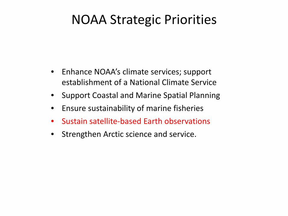
NOAA Strategic Priorities
• Enhance NOAA’s climate services; support establishment of a National Climate Service
• Support Coastal and Marine Spatial Planning
• Ensure sustainability of marine fisheries
• Sustain satellite-based Earth observations
• Strengthen Arctic science and service.
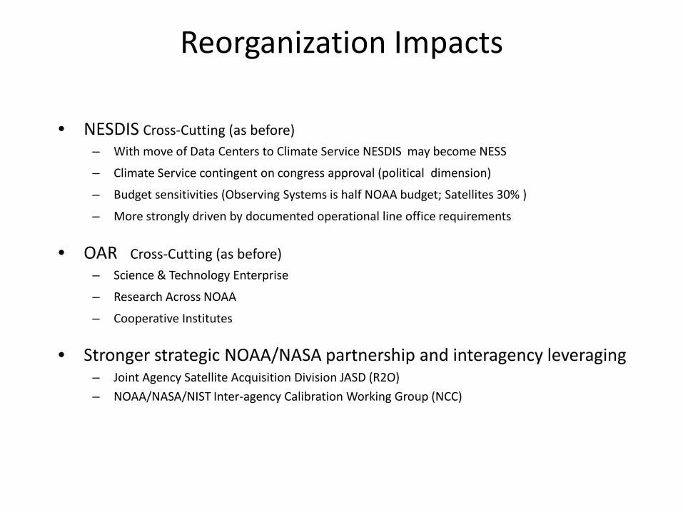
Reorganization Impacts
• NESDIS Cross-Cutting (as before)– With move of Data Centers to Climate Service NESDIS may become NESS
– Climate Service contingent on congress approval (political dimension)
– Budget sensitivities (Observing Systems is half NOAA budget; Satellites 30% )
– More strongly driven by documented operational line office requirements
• OAR Cross-Cutting (as before)– Science & Technology Enterprise
– Research Across NOAA
– Cooperative Institutes
• Stronger strategic NOAA/NASA partnership and interagency leveraging– Joint Agency Satellite Acquisition Division JASD (R2O)
– NOAA/NASA/NIST Inter-agency Calibration Working Group (NCC)
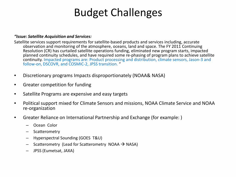
Budget Challenges
“Issue: Satellite Acquisition and Services: Satellite services support requirements for satellite-based products and services including, accurate
observation and monitoring of the atmosphere, oceans, land and space. The FY 2011 Continuing Resolution (CR) has curtailed satellite operations funding, eliminated new program starts, impacted planned continuity schedules, and have required some re-phasing of program plans to achieve satellite continuity. Impacted programs are: Product processing and distribution, climate sensors, Jason-3 and follow-on, DSCOVR, and COSMIC-2, JPSS transition. “
• Discretionary programs Impacts disproportionately (NOAA& NASA)
• Greater competition for funding
• Satellite Programs are expensive and easy targets
• Political support mixed for Climate Sensors and missions, NOAA Climate Service and NOAA re-organization
• Greater Reliance on International Partnership and Exchange (for example: )
– Ocean Color– Scatterometry– Hyperspectral Sounding (GOES T&U) – Scatterometry (Lead for Scatterometry NOAA NASA)– JPSS (Eumetsat, JAXA)
Status of Current Systems
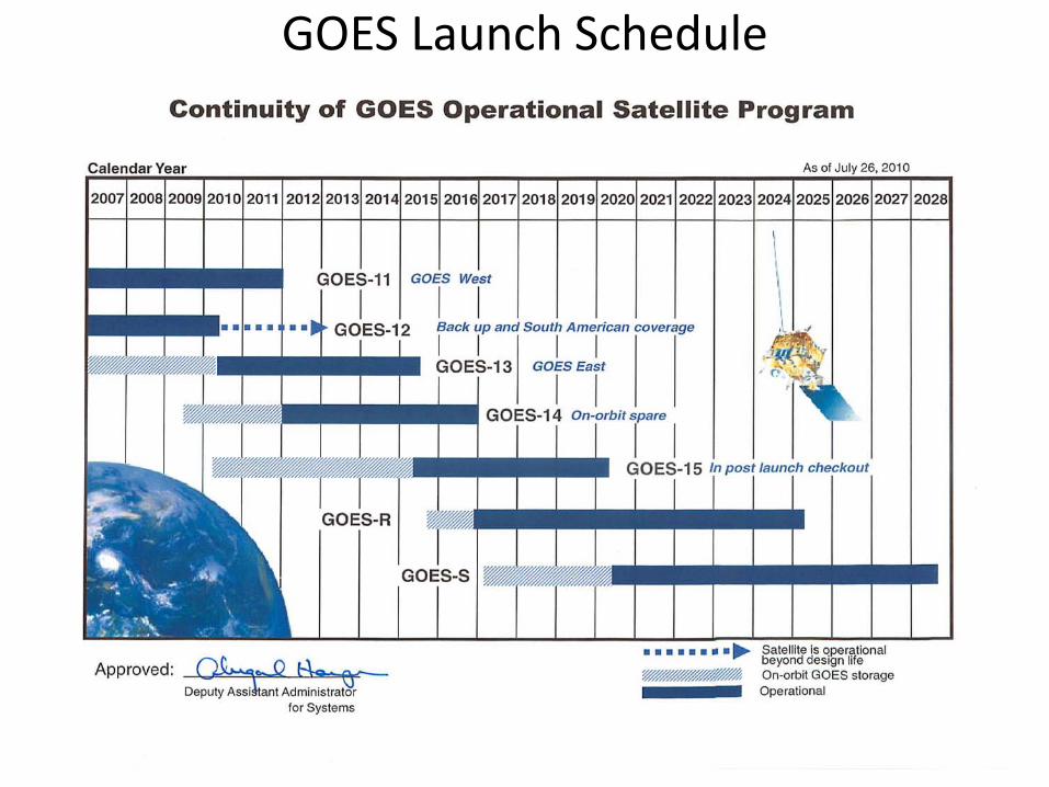
GOES Launch Schedule
10

11
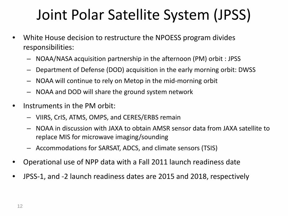
Joint Polar Satellite System (JPSS)• White House decision to restructure the NPOESS program divides
responsibilities:– NOAA/NASA acquisition partnership in the afternoon (PM) orbit : JPSS
– Department of Defense (DOD) acquisition in the early morning orbit: DWSS
– NOAA will continue to rely on Metop in the mid-morning orbit
– NOAA and DOD will share the ground system network
• Instruments in the PM orbit:– VIIRS, CrIS, ATMS, OMPS, and CERES/ERBS remain
– NOAA in discussion with JAXA to obtain AMSR sensor data from JAXA satellite to replace MIS for microwave imaging/sounding
– Accommodations for SARSAT, ADCS, and climate sensors (TSIS)
• Operational use of NPP data with a Fall 2011 launch readiness date
• JPSS-1, and -2 launch readiness dates are 2015 and 2018, respectively
12
International Collaborations
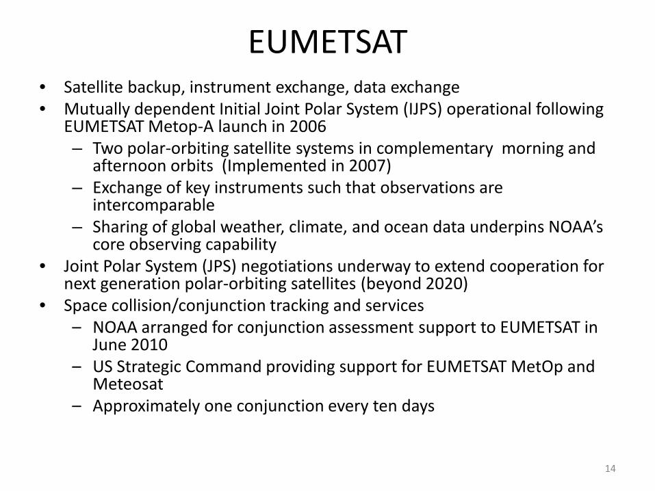
EUMETSAT• Satellite backup, instrument exchange, data exchange• Mutually dependent Initial Joint Polar System (IJPS) operational following
EUMETSAT Metop-A launch in 2006– Two polar-orbiting satellite systems in complementary morning and
afternoon orbits (Implemented in 2007)– Exchange of key instruments such that observations are
intercomparable – Sharing of global weather, climate, and ocean data underpins NOAA’s
core observing capability• Joint Polar System (JPS) negotiations underway to extend cooperation for
next generation polar-orbiting satellites (beyond 2020)• Space collision/conjunction tracking and services
– NOAA arranged for conjunction assessment support to EUMETSAT in June 2010
– US Strategic Command providing support for EUMETSAT MetOp and Meteosat
– Approximately one conjunction every ten days
14

France
15
• France has Europe’s premiere national space program
• French Space Agency (CNES) fruitful cooperative relationship with NOAA, both bilaterally and in multilateral fora since 1970s
• Argos Data Collection System: initiated between NOAA and CNES in 1974; collects data on atmospheric pressure, sea temperature, ocean current velocity, animal migration patterns, and river water levels
• Cospas-Sarsat Search and Rescue: an international satellite-aided search and rescue system; the governing parties of the system are the U.S./NOAA, France/CNES, Russia, and Canada. NOAA provides space on its polar-orbiting satellites for the French processor and Canadian receiver
Other European Cooperation• Successful cooperation (with EUMETSAT, France/CNES and NASA) on
Jason-2 mission providing for sea surface height measurements (Implemented 2008), with Jason-3 launch planned in 2013
– Sea level rise and climate change
– Ocean circulation and modeling
– Forecasting El Niño/La Niña
– Hurricane intensity prediction
• European Space Agency – potential partnership with ESA regarding the Sentinel series of operational Earth observation satellites
• Norway – high latitude ground station support for polar missions, i.e. POES, JPSS, COSMIC, GCOM
• European Union emerging role in space – letter of intent signed with EU Joint Research Center regarding research collaboration in many areas within NOAA purview
• Exploring possible cooperation with UK and Italian space agencies16

JapanJapan Aerospace Exploration Agency (JAXA)• Advanced Land Observing Satellite (ALOS) 2005: continued access to synthetic
aperture radar data for operational ice forecasts and research
• Global Change Observation Mission – Water (GCOM-W1): JAXA to provide data from the Advanced Microwave Scanning Radiometer -2 which fulfills unmet Joint Polar Satellite System (JPSS) requirement; NOAA to provide ground segment support; Ground Processing for SGLI
• GCOM-C1: NOAA seeking access to ocean color data
• JPSS: Plans for a Ground Receptor at Hatoyama, Japan
• GCOM-W2: potential partnership with JAXA and JPL to fly a NOAA Dual Frequency Scatterometer (DFS); possible CEOS Constellation effort
• Dual Frequency Precipitation Radar (GPM, NASA)
Japan Meteorological Agency (JMA) • Backup agreement for geostationary weather satellite coverage
• Scientific exchanges on future geostationary weather satellite series GOES-R and Himiwari; ABI and AHI imagers; Science Algorithms and Cal/Val
17

India: Oceansat-2• In November 2009, NOAA, NASA, and ISRO signed a Letter of Intent to explore
collaboration on Oceansat-2 activities• Currently drafting separate, but parallel, NOAA-ISRO and NASA-ISRO
Implementing Arrangements • There is an immediacy in acquiring Oceansat-2 scatterometer data because of
QuikSCAT’s operational end of life in November 2009– QuikSCAT was the primary source of wind observations providing warning
criteria of waves and life-threatening marine conditions • Oceansat-2 Ocean Color• NOAA & MoES/IMD INSAT-3D data and science applications; data exchange
18
Taiwan: COSMIC
• COSMIC-1 (NSF, UCAR, NOAA, JPL effort) provides real-time global atmospheric temperature and moisture data through a GPS radio-occultation measurement technique
• GPSRO data is valuable in improving the NWS forecast accuracy
• NOAA will collaborate with the Taiwan National Space Organization (NSPO) for the launch of 12 COSMIC-2 satellites to provide replenishment and operational upgrade of the current COSMIC-1 constellation
– NOAA to provide sensors through JPL, launch services, ground station support and sensor processing support
– Taiwan to provide spacecraft and integrate sensors
19
China Meteorological Administration
• Current cooperative activities include joint work on:– Satellite instrument intercalibration and validation
– Algorithm development
– Satellite data assimilation into Numerical Weather Prediction (NWP) models
– Operational data exchange • China FY-series satellite data valuable for improving US NWP models
• CMA access to POES global data sets to augment current POES overflight data
– Hyperspectral Sounder Future FY-3E (am)
– Scatterometer (SWMR) Future FY-3E
20
Russia
• 2005 MOU between NOAA and ROSHYDROMET establishes cooperation in Meteorology, Hydrology and Oceanography
• Joint Work in Satellite Hydrology includes:
– Use of Russian Meteor satellite data in operational weather forecasting in Alaska region
– Calibration and validation of satellite instruments beginning with Meteor-2 mission
– Develop new volcanic ash products
21

Canada CooperationRADARSAT- 1, 2 and Constellation
– USG access to RADARSAT-1 data in exchange for U.S. -provided launch under Canadian Space Agency, NASA, and NOAA agreement.
– U.S. National Ice Center was the largest single user of RADARSAT-1 data.
– RADARSAT-2 commercial data access only.
– RADARSAT Constellation (2014) most likely full and open data access for NOAA and National Ice Center. NOAA participating in joint algorithm and product development; calibration and validation; and possible data acquisition, processing, distribution, and archive.
Polar Communication and Weather (PCW) Mission
• Two satellite HEO mission; first launch date 2017.
• Will follow a “Full and Open” data policy.
• The primary met instrument will most likely be a GOES-R ABI-like instrument procured by Canada from U.S. industry. Canadian Government waiver required to procure outside Canada
– If so, significant opportunities for co-development of algorithms, products, cal/val,
• Important Arctic focus. Will Provide unique data sets, products, and research opportunities for region above 50° north.
• Exploring possible NOAA contributions such as data acquisition, processing, distribution and archive.

Brazil• Strong Partnership with GOES- South America
– GOES-10 &12 data and products are no longer distributed or archived by NOAA
– INPE is acquiring, processing, distributing and archiving data and products
– INPE providing training in Latin America on use of the data and products
• Strong part in GEONETCast America’s near real time satellite-based data dissemination system
– Brazil providing ground station technical assistance, training, products and support for the system
• Brazil approached NOAA to explore collaboration to fly NOAA instrument(s) on a Brazilian satellite
– Brazil seeking to establish a geostationary satellite capability
– Possibility of providing INPE with spare GOES-Q instruments
23

Other Partners
• Australia – collaborative projects on marine and climate change science and ocean color remote sensing
• Argentina – strong partnership on GOES South America and possible collaboration to fly NOAA instrument(s) on an Argentine satellite
• Korea – interest in potential cooperation and access to data from geostationary met/ocean satellite and future radio occultation satellite instrument; COMS Ocean Color; KOMSAT?
• JPSS – potential ground receptors in: Australia*, India*, Brazil, Japan, South Africa, New Zealand, Norway, Spain (*MOU is in place)
24

Summary
• Agencies cannot go it alone
– Observational requirements require global efforts
– Observational requirements can overwhelm individual agency budgets and infrastructure
• International Partnerships
– Meet critical needs of the global climate community
– Reduce duplication of effort as well as risks
– Bring diversity of ideas and capabilities to research and development
• NOAA is committed to working with interagency and international partners to provide continuous, high-quality, and timely observations in support of societal and economic decision-making;